
Check out these articles
-
 Video article 1:39
Baikamo – Flowers That Bloom Only in the Clearest Water. Beautiful Underwater Images of the Summertime Flower
NatureTravel- 240 plays
- YouTube
-
Video article 6:28
Super beautiful 4K video of the spectacular spring scenery of "Oirase Keiryu" in Towada City, Aomori Prefecture! Super soothing and spectacular video of nature surrounded by fresh greenery with background music!
TravelNature- 559 plays
- YouTube
-
Video article 2:48
The Beautiful Ogawa Falls in Kagoshima Prefecture's Kimotsuki District. The Emerald Green, Crystal Clear Waters Are Truly Captivating! So Beautiful It Was Even Used for One of NHK's Long Running Dramas!
TravelNature- 432 plays
- YouTube
-
Video article 4:24
Breathe in the Fantastic Atmosphere at Kameiwa Cave in Kimitsu, Chiba! It's Like Being Lost in a Mystical World!
Nature- 397 plays
- YouTube
-
Video article 3:43
Nabegataki Falls - A Beautiful Travel Destination Surrounded by Nature in Kumamoto Prefecture
NatureTravel- 580 plays
- YouTube
-
Video article 5:38
Taste the great outdoors at Kamikochi in the Japanese Alps, a spectacular sightseeing spot in Matsumoto City, Nagano Prefecture, Shinshu! Surrounded by greenery full of negative ions, spend a healing time.
Nature- 221 plays
- YouTube
-
Video article 2:07
Why is Kakita River Spring Water, a Mysterious Clear Stream in Sunto-gun, Shizuoka Prefecture, Blue! Watch a video of the Kakita River, fed by melted snow from Mt! Also, the highlights of Kakita River Park with its power spots!
NatureTravel- 409 plays
- YouTube
-
Video article 11:19
Enjoy a Cup of Pure Bliss in the Great Outdoors! Enjoy an Out-of-the-Ordinary Experience With Coffee Brewed From the Spring Water of Oike Spring in Oita Prefecture
Nature- 35 plays
- YouTube
-
Video article 3:03
The Niyodo River in Shikoku Is Famous for Having the Clearest Waters of All Rivers in Japan! Enjoy the Mystical World of the Crystal Clear Waters Coined "Niyodo Blue"!
Nature- 289 plays
- YouTube
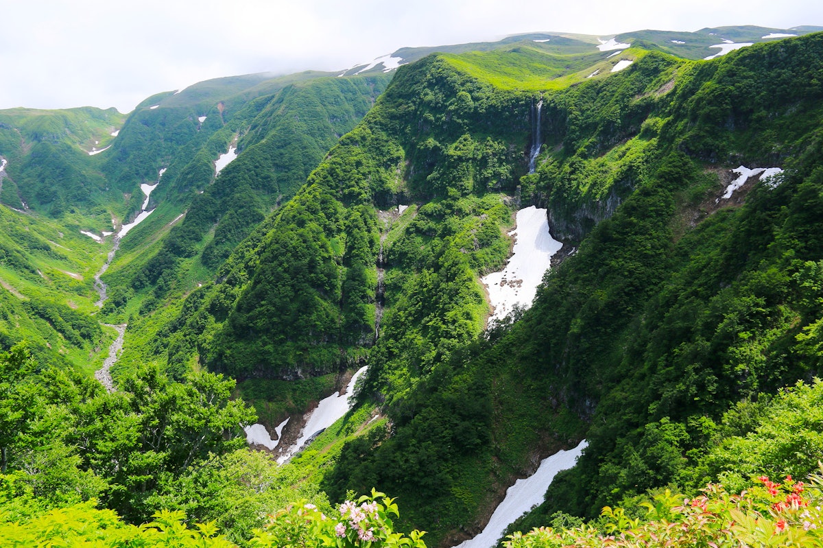
Enjoy the magnificent nature at the Chokaisan-Tobishima Geopark in Nikaho City, Akita Prefecture! Don't miss this video if you want to enjoy the beauty of Shirataki Falls in Mototaki subterranean water!
Chokaisan-Tobishima Geopark, Nikaho City, Akita Prefecture, Japan Video Introduction
This video, titled “[4K UHD ] Mt. Chokai/Tobishima Geopark: Fresh Greenery and Mototaki Falls (Shot on GH5 With Gimbal)” ([ 4K UHD ]鳥海山・飛島ジオパーク: 新緑の元滝伏流水 Moto-taki Waterfall ( shot on GH5 with Gimbal)), was released by “AQUA Geo Graphic.”
Mt. Chokai & Tobishima Geopark is the name of Akita Fuji (秋田富士), Dewa Fuji (出羽富士), and Shonai Fuji (庄内富士), which have been selected as some of the 100 Famous Mountains and 100 Famous Geographical Features of Japan.
Furthermore, it is also the name of the "Mysterious Island Tobishima" and "Chokai National Park," which is located about 30 km west of Mt. Chokai, and was recognized as a Japan Geopark in 2016.
Nowadays it's called Mt. Chokai, but in ancient times it was known as "Torimiyama" and you could see a 360-degree view of the horizon from the top.
Due to volcanic eruptions and other volcanic activities, this view is no longer visible and it is now called Mt. Chokai.
The overall theme is "The cycle of water and life created by the Japan Sea and the plateau," and the sub-theme is "Nature and life created by warm currents, active volcanoes, and spring water."
In this article, we'll introduce the "Mototaki Underflow," an ethereal waterfall flowing down a rock face at the foot of Mt. Chokai in the Mt. Chokai & Tobishima Geopark area.
What Exactly is a “Geopark”?
The word "geopark" (“ジオパーク” jiopaaku in Japanese) is a combination of the words “geo” and “park.”
It was selected for the purpose of learning about the natural environment and ecosystems that spread across the land, as well as the culture and industries that people have created.
At present, there are 43 areas selected as Japan Geoparks, and 9 of them are also recognized as UNESCO Global Geoparks.
As they are sometimes called "大地の公園" (Daichi no Kouen, lit. "Earth Parks") in Japanese, they are famous for the various scenery they offer throughout the year, and are especially popular during the fall with the autumn leaves change to beautiful shades of red and yellow.
There is also a sake brewery in the area that uses clean spring water, so if you like sake, be sure to take a tour of the brewery.
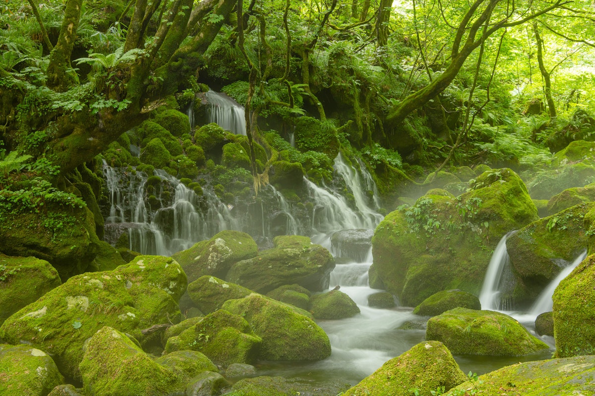
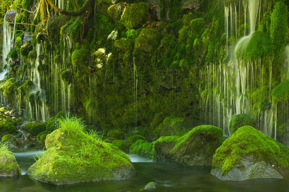
The Mototaki Underflow Located at the Foot of Mt. Chokai
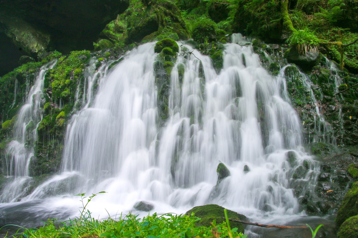
The Mototaki Underflow is located at Mt. Chokai in Nikaho City, Akita Prefecture.
Although it is called "Mototaki" (元滝, lit. "source waterfall"), the original source of the subterranean waterfall is currently closed to traffic, and the Mototaki Underflow is located about 200 meters downstream.
As you can see from 0:42 in the video, the waterfall is relatively small, only 5 meters tall and about 30 meters wide, yet 50,000 tons of water flow from it each day.
The fantastic scenery created by the moss and the subterranean stream flowing out of the gaps in the green rocks is fascinating, and surely allows for some beautiful photos to share on Instagram.
Recommended Sightseeing Destinations Around the Mt. Chokai & Tobishima Geopark Area
1. Mt. Chokai Omonoimi Shrine/Fukura Kuchinomiya (Chokaisan Omonoimi Jinja Fukura Kuchinomiya)
An old shrine, said to be the oldest shrine in the Shonai region, with origins dating back to 1963.
It sits on the summit of Mt. Chokai, and there are two satomiya (shrines built in a village for the convenience of worshippers) called "Kuchinomiya" (口ノ宮, lit. "entrance shrines") at the foot of the mountain, one at Fukuura and the other at Warabioka.
2. The Shirai Rice Fields and Weirs
This farmland was developed in 1800 based on the concept of rice fields for the Han-School of Shonai Chido-kan by Yadayu Shirai, the county representative of the Shonai domain.
There are many innovative ways to heat and utilize the cool spring water of Mt. Chokai, and you can see the fruits of the wisdom of the area's ancestors here.
It's a 10-minute drive east from Yuza Station.
3. Hokotate Observatory
Mt. Chokai & Tobishima Geopark is also famous for its mountain climbing, and the Hokotate Observatory is a popular tourist spot where you can enjoy the magnificent view of Mt. Chokai.
The observatory is located at the fifth station of the mountain, which can be reached by car, so it's possible to stop by during your drive, and there are a number of mountain lodges on the way to the summit, so you can take breaks as you go.
When climbing the mountain, we recommend asking for a mountain guide or participate in a geotour so that you can learn more about Mt. Chokai.
4. Chokai Blue Line
Chokai Blue Line is a mountainous road that rises from zero to 1,100 meters above sea level, and during the fall, amongst the autumn foliage, it offers a spectacular view worthy of any bucket list.
Summary of Mt. Chokai & Tobishima Geopark
Mt. Chokai and Tobishima Geopark has become a nature-rich spot called "緑のダム" (The Green Dam) due to the planting of beech trees by the townspeople to preserve water quality and purify the water source.
In addition to sightseeing, be sure to try some gourmet foods like delicious Akita Iwagaki Oysters, which contain many minerals from the spring water!
【Tripadvisor】Mt. Chokai
https://www.tripadvisor.com/Attraction_Review-g298237-d1397297-Reviews-Mt_Chokai-Tohoku.html
AccessMap (Google Maps)
-
Video article 3:43
Saiho-ji Temple (Koke-ji Temple) in Kyoto in autumn is beautiful with moss and autumn leaves! Visiting this famous temple with its wonderful buildings is by appointment only!
Nature Travel Traditional Culture- 561 plays
- YouTube
-
Video article 3:12
Mt. Daisen and Kitanizawa Stream - Two Places Used to Make Commercials With Famous Artists! Be Amazed by the Natural Scenery of Tottori Prefecture in This 4K Video!
Nature- 477 plays
- YouTube
-
Video article 2:09
Spectacular view of lush tea fields and Mt! Fuji, Shizuoka Prefecture, a popular photo spot for foreign tourists!
Nature Travel- 739 plays
- YouTube
-
Video article 3:43
Nabegataki Falls - A Beautiful Travel Destination Surrounded by Nature in Kumamoto Prefecture
Nature Travel- 580 plays
- YouTube
-
Video article 1:05
Amanohashidate, Miyazu City, Kyoto, Japan, winter spectacular sightseeing video!Aerial video that makes you feel as if you are flying in the sky! Go on a trip to enjoy the dignified and clear winter air!
Nature Travel- 1.36K plays
- YouTube
-
Video article 1:56
Shojohama Beach in Mikata-gun, Fukui Prefecture, is called the best paradise beach in Japan.The Sea of Japan has such clear and transparent cobalt blue waters!
Nature- 483 plays
- YouTube
-
Video article 2:44
Yuni Garden in Yuni Town, Hokkaido is famous for its kochia! Aerial video of the best time to visit and seasonal flower attractions.
Nature Travel- 334 plays
- YouTube
-
Video article 4:00
Superb 4K video of beautiful rice fields in Aizuwakamastu City, Fukushima Prefecture! The scenery of golden rice ears dyed by the setting sun is soothing.
Nature- 512 plays
- YouTube
-
Video article 9:58
One of the Largest in Japan! The Tulip Fields at Sera Kogen Farm in Hiroshima Are Beautiful Beyond Belief! This Brightly Colored Scene Is Something You Won't Want to Miss!
Nature- 327 plays
- YouTube
-
Video article 1:53
An Aerial View of the Powerful Whirlpools of the Seto Inland Sea! What Causes These Whirlpools, and Where Is the Best Place to View Them? Let’s Find Out!
Nature Travel- 491 plays
- YouTube
-
Video article 3:25
Nara Prefecture's Beautiful Ryuogabuchi Pond Is a Great Place for Taking Instagram Photos! Check Out the Video To See Its Beauty for Yourself!
Nature Travel- 457 plays
- YouTube
-
Video article 3:54
Autumn Foliage & Ginkgo Trees at Hikarigaoka Park 2025 | Best Viewing Times, Access & Illumination Complete Guide
Nature Travel Local PR- 275 plays
- YouTube


Comment