-
Article
-
Channel
-
Region
-
Season
-
Tag
Articles
-
 Video article 3:00
San'in Kaigan Geopark - An Amazing Geopark in Japan! Discover the Beauty of This Diverse UNESCO Global Geopark!
Travel Things to Do Nature- 322 plays
- YouTube
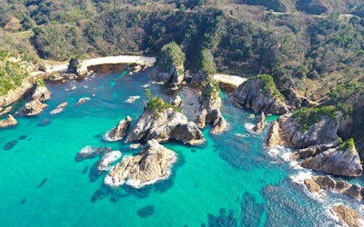
Video Introduction: San'in Kaigan Geopark - A Bird's Eye View of Kami This video, titled "Kami, Hyogo - Drone PR Video (Sea Edit)" (香美町ドローンPR映像(海編)), was uploaded by "Kami, Hyogo - Tourism, Commerce, and Industry Bureau [Official]" (兵庫県香美町 観光商工課). More About the San'in Kaigan Geopark The San'in Kaigan Geopark is recognized as a UNESCO Global Geopark. It refers to a large area of more than 100 km east to west, consisting of San'in Kaigan National Park and the surrounding area, which spans six cities and towns, including Kami, Hyogo in Japan's Kansai Region, Kyotango, Kyoto; Toyooko and Shinonsen in Hyogo, and Tottori City and Iwami in Tottori Prefecture. San'in Kaigan Geopark Trail - Spectacular Views of Precipitous Cliffs Photo:San'in Kaigan Geopark The main feature of the San'in Kaigan Geopark Trail is the sheer cliffs and various landforms along the coastline, as well as the scenery of the Sea of Japan, all of which can be enjoyed via the 27 courses available. ・Yoshioka Onsen - Tottori Station Course: Walk along the banks of lagoons enclosed by sand dunes ・Aotani Station - Tottori City Shikano Socializing and Exchange Hall 'Dream' Course: Walk and feel the eruption of volcanoes and the erosive power of the sea ・Roadside Station Amarube - Yoroi Station Course: Walk in Satoyama with a view of the 41.5-meter-tall Amarube Viaduct Kami, a Small Town in Hyogo, Japan Photo:San'in Kaigan Geopark, Kami, Hyogo In addition to the San'in Kaigan Geopark, Kami, Hyogo, which is located in the San'in Kaigan Geopark, features a variety of other places to visit. For example, Sazu Beach, Imagoura, Okami Park, and the Obikinohana Observatory are all worth seeing. The sunset from Imagoura and the Obikinohana Observatory is truly spectacular! It is also a popular Instagram spot, attracting the attention of a wide range of people, young and old alike. The video shows the beautiful sunset from the Obikinohana Observatory. [Video] 2:22 - The Obikinohana Observatory at sunset Summary of the San'in Kaigan Geopark Photo:San'in Kaigan Geopark The San'in Kaigan Geopark, consisting of six municipalities (Kami, Shinonsen, and Toyooko in Hyogo; Kyotango, Kyoto; Tottori City and Iwami, Tottori), offers a variety of sites and attracts many tourists. Visitors can also observe creatures living on the San'in Coast at the San'in Kaigan Geopark Museum of the Earth and Sea in Tottori Prefecture and the Kami Town Geopark & Marine Cultural Center in Hyogo Prefecture. There's also a sightseeing boat tour in Iwami, Tottori, where visitors can tour the islands of the Uradome Coast and admire the rich natural scenery from a boat. There are many Instagrammable spots where you can take great photos. The San'in Kaigan Geopark is one of the largest geoparks in Japan, spanning Kyoto, Hyogo and Tottori prefectures. There are a total of 27 courses! They are unique coastal trails with both mountain paths and coastlines. There are varying degrees of difficulty as well, so you can choose and plan the course that best suits your individual preferences. 【Official Website】San'in Kaigan Geopark https://sanin-geo.jp/know/en/ 【TripAdvisor】San'in Kaigan Geopark https://www.tripadvisor.com/Attraction_Review-g1022822-d10813685-Reviews-San_in_Kaigan_UNESCO_Global_Geopark-Toyooka_Hyogo_Prefecture_Kinki.html -
 Video article 3:47
The Caldera of Mt. Aso: A Magnificent Landscape Created by Nature. The Natural Wonderland, Full of Mysterious Scenery, Is Said to Have Been Created by the Gods!
Nature- 528 plays
- YouTube
The Caldera of Mt. Aso This PR video, titled "The Heritage of Tomorrow- God, Nature, and Man," is produced by “N.a” to promote Mt. Aso in Kumamoto Prefecture. The beautiful landscape of Kyushu, including Mt. Aso, can be seen throughout this video. Mt. Aso has a caldera produced by an ancient volcanic eruption, and the people have lived their lives here believing in the power of the gods and nature. A Caldera is a large circular depression in a volcano created from the body of the volcano collapsing. You can see a view of the caldera, billowing with volcanic smoke, in the video at 1:54. The Beautiful Scenery of Mt. Aso Photo:Aso Panorama Line Aso Shrine, known as the Ichinomiya of Higo province (肥後国 : Higono Kuni), and located at the foot of Mt. Aso, is a historic location, considered to be the number one shrine in Higo province. Its origins trace back to mountain and volcano worship in the Jomon period. Legend has it that the god of the shrine, Takeiwatatsumi no Mikoto, once kicked out water from the mountain in order to build a rice field around Mt. Aso. The area around Aso Caldera is designated as a Aso UNESCO Global Geopark. It's a beautiful location where you can learn about the natural landscape. At Aso UNESCO Global Geopark, focused on active caldera, you can see large clouds of smoke climbing high up into the sky. You can also enjoy a view of Aso Geopark in this video. Tourist Spots in the Mt. Aso Area! ©阿蘇市 Modifying Daikanbo (大観峰: Daikanbo) is the highest peak at Aso Kitagairin Zan (阿蘇北外輪山:Aso Kitagairin Zan) in Aso city阿蘇市 : Aso-shi). From the Daikanbo observantory, you can enjoy a spectacular view of the "Five Mountains of Aso" (阿蘇五岳: Aso Gogaku). The Aso Milk Road leading to Daikanbo is great for sightseeing. There's a parking lot and it can be easily accessed, so we definitely recommend checking it out if you have the chance. Some other hidden gems where you can explore the natural scenery of Mt. Aso include Shirakawa Suigen and Kusasenrigahama. Relax in the Hot Springs and Feel the Blessings of Nature! Photo:Kurokawa Hot Springs There are a lot of hot spring facilities around Mt. Aso due to the many volcanoes in the area. One that we recommend visiting is Kurokawa Hot Springs. We especially recommend Aso Farm Land, created with the idea of promoting health. You can enjoy delicious local cuisine and natural hot springs to heal your body after exploring Mt. Aso. Summary of Mt. Aso There are many sightseeing spots where you can experience the beautiful landscape of Mt. Aso. In the video, you can enjoy beautiful views of Mt. Aso with calm music playing in the background. Enjoy the mysterious scenery of Mt. Aso, famous as a land created by the gods. There are many volcanoes in Japan besides Mt. Aso. People have lived in reverence for them since ancient times. We hope to see you at Mt. Aso to enjoy the relaxing hot springs, beautiful scenery, and the spiritual shrines! 【Tripadvisor】Asosan (Takadake) https://www.tripadvisor.com/Attraction_Review-g298212-d320703-Reviews-Mt_Aso-Kumamoto_Prefecture_Kyushu.html -
Video article 1:36
Viewer Discretion Advised! Mass Amounts of Pollen! Learn About the Causes, Symptoms and Treatments of Hay Fever, Which Affects Many People in Japan!
Nature- 1.23K plays
- YouTube
What Is Hay Fever? If you’re allergic to cedar pollen, just watching this video might cause you hay fever symptoms. The video, titled "スギ花粉の飛散 Cedar Pollen Dispersal ( Shot on RED EPIC High-speed )," is a super high-speed video that shows detailed footage of cedar pollen dispersing. It was created by "AQUA Geo Graphic." People with cedar pollen allergies show start to flare up just after watching some yellow cedar pollen be dispersed on TV commercials for anti-allergy medicine. It’s said that there are currently 25 million people with hay fever in Japan. The most common form of hay fever is cedar hay fever, but the number of people who suffer from other types of pollens, such as cypress, ragweed, and birch pollens, has been increasing rapidly, and countermeasures for hay fever are needed throughout the year. Treatment of Hay Fever Photo:A woman blowing her nose Is there any treatment for hay fever, which causes painful attacks every year when the pollen season arrives? In short, the only way to treat hay fever at its root is sublingual immunotherapy for cedar pollen allergies. In this treatment, a weakened cedar pollen pill is placed under the tongue and gradually taken into the body, in an attempt to get the patient’s body used to cedar pollen. The therapy takes more than 2 years and those who have severe hay fever attacks can have them during the treatment, so it’s not an effective cure for all, but it’s more than 60% likely to abate symptoms of cedar hay fever. For other types of pollen allergies, symptomatic treatment with medication or evacuation to pollen-free areas (Hokkaido and Okinawa) is necessary. Regarding anti-allergy drugs, the most effective ones are prescribed drugs, but over-the-counter drugs can be sufficiently effective as well if you act preemptively by using them before the pollen in the air is at its peak. The Causes of Hay Fever Photo:Cedar pollen Cedar pollen is called wind-borne pollen because it's dispersed by the wind. At the start of the video, you can see a large amount of pollen being dispersed by the wind on the branches of a cedar tree. According to the Ministry of Agriculture, Forestry and Fisheries, evergreen coniferous trees (cedar and cypress) are native to Japan, and their straight wood, which is not distorted, is suitable for use as lumber for wooden buildings, so large scale cedar plantations were established to revitalize the forestry industry after World War II, which led to major outbreaks of hay fever. The name "花粉症, kafunsho" ('hay fever' in Japanese), was first coined in October 1963, when the existence of allergic symptoms caused by cedar pollen was identified and presented at the annual meeting of the Japanese Society of Allergology in the fall of that year. The size of cedar pollen is just smaller than a heliozoan and can be seen with the naked eye using an optical microscope. Each cedar flower contains about 400,000 pieces of pollen, so during strong winds, large amounts are dispersed. When Do Hay Fever Symptoms Appear? Photo:Hay fever symptoms The Tokyo Metropolitan Government's Bureau of Public Health has been providing pollen information since 1985, and nowadays, the Japan Meteorological Agency and private meteorological forecasting services provide forecasts for the start of pollen dispersal and pollen distribution throughout the year. You can also check pollen forecasts for plants other than cedar, cypress, and ragweed on the Internet, so if you have hay fever, be sure to stay up to date. Even after December, when peak pollen dispersion has passed, early spring hay fever may come straight after the cold and flus of the year, so be sure to take countermeasures, such as keeping your room humid, ventilate and clean frequently, wash your hands, and gargle. Summary of Cedar Pollen and Hay Fever Cedar pollen allergies, which were once thought to be endemic in Japan, have spread, and are now common worldwide. Tomatoes can also worsen hay fever, so we recommend avoiding them during hay fever season! -
Video article 6:28
Super beautiful 4K video of the spectacular spring scenery of "Oirase Keiryu" in Towada City, Aomori Prefecture! Super soothing and spectacular video of nature surrounded by fresh greenery with background music!
Travel Nature- 422 plays
- YouTube
Video introduction of "Oirase Keiryuu in fresh green" in Towada City, Aomori Prefecture Located in Northern Japan in Towada city, Aomori, Oirase Gorge is a main attraction among Japanese tourist spots. Oirase stream, which has a total length of about 14 km, is blessed with beautiful weather throughout the year, and in the spring, the spray of the clear stream is reflected in the lush greenery. The riversides forest and streams are a paradise for plants and animals, such as wild birds, serows, chars, Tohoku salamanders and other precious flora and fauna. From the moment you step inside, you'll be overwhelmed by the mystique of these woods. This video introduces the beauty of Oirase Gorge’s fresh greenery with a wonderful BGM. It's in 4K, so be sure to enjoy the beautiful footage in full screen. So Many Places to See! Recommended Tourist Spots at Oirase Gorge! Photo:The Fresh Greenery of Oirase Mountain Stream The recommended route of the Oirase River is a trail from the mouth of the Oirase River, which leads from Nenokuchi to the Shimei Gorge and then to Yakeyama. There are mossy benches throughout the trail and you can take some beautiful pictures, perfect for Instagram, especially during spring. On the way from Ishikedo (石ヶ戸の瀬, Ishikedo no se) to Kumoi Falls (雲井の滝, Kumoi no taki), you'll come across a huge rock called Makado (馬門岩, Makadoiwa Rock). The highlight of Oirase stream is the Flow of Ashura(阿修羅の流れ, Ashura no nagare). According to local legends, Ishigedo resthouse, the only rest house along Oirase stream, operated as a base for female bandits long ago. This popular route is perfect for walking as it includes Choshi Falls (銚子大滝, Choshi Oodaki), Nenokuchi water gate (子ノ口の水門, Nenokuchi no suimon), Samidare stream (三乱の流れ, Samidare no nagare), and other amazing views. Oirase Gorge was designated as a place of scenic beauty and a natural monument in 1928, and in 1936, it was designated as Towada National Park. You can see the majestic greenery, waterfalls, and powerful river in the video as well. Food & Access Information for Oirase Gorge Photo:Grilled salted fish At hotels and ryokan around Oirase Gorge, you can enjoy natural hot springs and local dishes using locally grown vegetables and freshly caught trout. One of the most famous hotels is "Hoshino Resort Oirase Keikyu Hotel." At Oirase Gorge's neighborhood facility "Oirase Stream Museum," there's a diorama of Towada Hachimantai, and "Community Land," where you can learn about history and nature. To get to Oirase Gorge, you can take local bus from Aomori airport, Misawa airport, JR Aomori station, JR Misawa station or JR Towada station. You can get more details on the official page for Towada Lake National Park Association. There are different kinds of tours so pick your preference and enjoy your time at Oirase Gorge. Summary of Oirase Gorge Oirase Gorge's source is lake Towada. There are a number of waterfalls and rapids, and you can enjoy the abundant greenery of the surrounding area. The video shows a lot of scenic spots at Oirase Gorge. Feel the beauty of nature even more with the sound of the flowing river which doubles as a BGM. The video shows us the seasonal beauty of Oirase Gorge, so we can enjoy the beauty of spring. If you've watched the video already, I bet you're already packing your bags! 【Official website】Lake Towada National Park Association http://towadako.or.jp/en/ -
Video article 3:56
Experience the 1200-Year Old Pilgrimage "Shikoku Henro." Journey to the 88 Sacred Sites and Connect With Japanese History and Nature
Traditional Culture Art & Architecture History- 171 plays
- YouTube
About Shikoku Henro The video "Japan the Beautiful, Shikoku Henro" ([美しき日本] 四国 四国遍路), is about the Shikoku Pilgrimage, also known as Shikoku Henro. Shikoku Henro is a walking route that takes you to the 88 temples of Shikoku Island, in the four prefectures of Tokushima, Kagawa, Ehime, and Kochi. This article takes a look at the charms of this ancient route. The video navigates us through the beautiful landscapes of Shikoku Henro, and the distant view of the mountains, clad in green amongst the blue skies, make viewers feel as if their on the pilgrimage themselves. What is Shikoku Henro? Photo:Kobo Daishi statue Shikoku Henro is a multi-site pilgrimage of 88 temples associated with the Buddhism monk Kukai (Kobo Daishi) on Shikoku Island. Pilgrims are called "ohenro-san." The pilgrimage was practiced exclusively by ascetic monks until the Edo Period when the teaching of Kukai became widely spread across the country due to infrastructure developments, and commoners subsequently traveled to Shikoku Island to trace the path of Kukai and pray for good health. The culture of "osettai" by the Shikoku locals to support the safe journeys of ohenro-san by offering meals and shelter, has been maintained for roughly 300 years. In 2015, Shikoku Henro was added to the Japan Heritage list. The pilgrimage is quite exhausting due to the mountains and valleys, but it gives you a profound spiritual experience. Making the Shikoku Henro Pilgrimage Photo:Shikoku Henro You can visit any temple you want, but many people start at Temple 1 and visit them in order. After offering prayers at a temple, pilgrims receive a red seal stamp (known as Goshuin) in their stamp book. The motto to symbolize Shikoku Henro is expressed by the word "dogyo ninin" (Traveling together), which means that a pilgrim traveling alone is accompanied in spirit by the monk Kukai at all times. There exists a custom to visit the mausoleum of Kukai, Koyasan (Mt.Koya) Okunoin Temple in Wakayama Prefecture, after completing the pilgrimage route as well. Tips for Making the Pilgrimage Source :YouTube screenshot Shikoku Henro takes around 50 days on foot. You can take breaks to go sightseeing or enjoy local dishes. Staying at local inns, referred to as "henro-yado," also offers a refreshing experience, allowing you to relax and continue the pilgrimage at your own pace. The video portrays a traveling pilgrim taking steps forward on the route winding through the mountains and valleys. The natural beauty of Shikoku Henro is breathtaking. There is no designated clothing that pilgrims must wear, but they are often clad in white robes and a ceremonial stole, a cone-shaped hat to protect them from the sun and rain, and holding a wooden staff which is said to represent the body of Kukai and support the pilgrim along the way. Wearing the classic pilgrim clothing will help you feel ready for the journey. Summary of Shikoku Henro Experiencing the pilgrimage will lead you to discoveries that lay deep within the depths of Japanese culture and history. Tracing the ancient path of the pilgrimage, you may encounter yet undiscovered gems. Furthermore, the beautiful natural environment and the local custom of selflessly helping and supporting another may also lead to self-discovery and personal growth. -
Video article 3:55
Daisekirinzan - A Place Where You Can Enjoy the Magnificent Nature of Okinawa, Unchanging Since Ancient Times! Leave Behind the Hustle and Bustle of the City on the Famous Trekking Courses!
Nature- 80 plays
- YouTube
Daisekirinzan in Kunigami District, Okinawa Prefecture This video, "Oishi Forest Mountain|A walk in the sky" (大石林山 空中散歩), was created by "Okinawaworld." Daisekirinzan is a mountain in Okinawa's Kunigami District, about a 3-minute drive from Cape Hedo (辺戸岬, hedo-misaki), the northernmost point of the main island of Okinawa. As seen from 0:15 in the video, the island has a karst landscape created by limestone from 250 million years ago. The many strange rock formations and beautiful scenery is reminiscent of Guilin in China, known for its depictions in ink paintings. Nearby is Ashimui (安須杜), which has been a sacred place since ancient times. From Cape Hedo, the mountains seem steep and forbidding, but once you actually enter the mountains, you'll find a peaceful paradise of subtropical flora and fauna. Most of Daisekirinzan is designated as a specially protected area of Yanbaru National Park. You can enjoy the magnificent nature of Yanbaru while making your way through the two main trekking courses. The History of Daisekirinzan Photo:Daisekirinzan, Okinawa Daisekirinzan is a "quasi-national park" in Okinawa, in accordance with the Natural Parks Act. The park is managed with the aim of protecting the beauty of nature and contributing to the health, recuperation, and knowledge of Japanese citizens. On September 15, 2016, along with the official designation of Yanbaru National Park, a part of the area previously designated as Okinawa Kaigan Quasi-National Park was transferred to Yanbaru National Park. Daisekirinzan is a must-visit sightseeing area in Okinawa, even winning the "Tripadvisor Excellence Award 2018" on TripAdvisor for the fifth consecutive year. The Two Main Trekking Courses of Daisekirinzan Photo:Banyan Tree in Oishi Forest Mountain, Okinawa ① Strange Rock / Churaumi Panorama Course As seen from 0:36 in the video, this is a course where you can experience the tropical karst landscape at the northernmost tip of Okinawa. It takes about 60 minutes to complete the 1,200m course. You can see the strange rocks and massive boulders from 0:45 in the video. In addition to strange rocks and boulders, there are also many places of worship, such as the "Stone Forest Wall," which is said to be full of spiritual power. There is also an observation deck where you can enjoy a panoramic view, and during good weather conditions, you can even see Yoron Island (与論島, yoron-to) and Okinoerabu Island (沖永良部島, okinoerabu-jima) in Kagoshima Prefecture (鹿児島県, kagoshima-ken). There is also a barrier-free course, which is 600 meters long and takes about 20 minutes to complete It's designed for the elderly and people in wheelchairs to enjoy. As seen from 2:00 in the video, there's also Eboshi-iwa Rock (鳥帽子岩) towering into the sky, as well as the mysterious Nabe-ike Pond (鍋池). ② Yanbaru Forest Course The Yanbaru Forest Course can be seen from 2:09 in the video. Even in the midst of Daisekirinzan, this is an area where the subtropical trees grow especially densely. It takes about 30 minutes to traverse the 1,000m-long course, and you can enjoy the magnificent natural scenery, including the huge banyan tree seen from 2:32 in the video. Summary of Daisekirinzan Photo:The Phantom Flower Mucuna Macrocarpa, Okinawa In addition to the two famous trekking courses, there are many other sightseeing spots in Daisekirinzan. The Okinawa Stone Culture Museum (沖縄石の文化博物館, okinawa-ishi no bunka hakubutsukan) is a geological and ethnic museum centered around Okinawan stones. Gajumaru Road (ガジュマルロード), also known as the "Path of the Wind" (風の道, kaze no michi) is a road winding along gorgeous scenery. If you're lucky, you might even get the chance to see the rare "Mucuna Macrocarpa," which grows naturally in the mountains of Yanbaru. Even Okinawans rarely come across this "phantom flower." In recent years, Daisekirinzan has been attracting attention as the largest spiritual area in Okinawa. Consider adding Daisekirinzan to your itinerary when you visit Okinawa! 【Official Homepage】Yanbaru National Park Daisekirinzan https://www.sekirinzan.com/en/ 【Tripadvisor】Daisekirinzan https://www.tripadvisor.com/Attraction_Review-g1025649-d1373544-Reviews-Daisekirinzan-Kunigami_son_Kunigami_gun_Okinawa_Prefecture.html -
Video article 4:40
Animation of the spectacular view of Cape Erimo sung "Nothing Spring" in Horosen-gun, Hokkaido! Introducing everything from nearby sightseeing spots to gourmet food!
Travel Nature- 179 plays
- YouTube
Cape Erimo" in Erimo-cho, Horosen-gun, Hokkaido, Japan This video, titled "Cape Erimo, a Spectacular View of Hokkaido|Short Version|DRONE×HOKKAIDO" (北海道の絶景・襟裳岬ショートバージョン DRONE×HOKKAIDO), was uploaded by "Shinji kawamura." The video features drone footage of Cape Erimo in Hokkaido, Japan. Be sure to check it out to see some of the amazing views that Cape Erimo has to offer! Amazing Views on Cape Erimo Photo:Hatsuhinode on Cape Erimo Many Japanese people have this idea that there's nothing to do on Cape Erimo. But, let's start with some basic information about Cape Erimo. Cape Erimo is located at the southernmost tip of the Hidaka Mountains, known as the backbone of Hokkaido, jutting out into the Pacific Ocean. A scenic tourist destination, Cape Erimo is located in Erimo, in Hokkaido's Horoizumi District. It is also known for its strong winds and the large amount of sea fog that occurs from May to August. The cape is approximately 60 meters tall, and from the tip of the cape, a reef continues for approximately 2 km, offering a magnificent view of nature's beauty. The spectacular view was designated as a national cultural asset, in August 2010, with the name "Meisho Pirikanoka" (meaning "beautiful shape" in the language of the Ainu)." Furthermore, Cape Erimo is also known as a spot for the Japanese tradition "Hatsuhinode" (the first sunrise of the year), and many tourists come to see the majestic sight. Cape Erimo is not a place with nothing, but rather, a popular spot where you can take Instagrammable photos. Cape Erimo - Now a Popular Tourist Spot! Photo:Cape Erimo, Hokkaido In Japan, there's a song called "Cape Erimo" that was sung by Chiyoko Shimakura. Later, in 1974, "Cape Erimo" composed by Takuro Yoshida and sung by Shinichi Mori became a big hit. The phrase in the lyrics, "Erimo no Haru wa nani mo nai Haru desu" (Spring in Erimo is a spring of nothing), left a lasting impression on people. This single phrase of the hit song made it famous as a place offering nothing. However, Cape Erimo is actually a place with loads of natural beauty, as mentioned above. It is now one of the most popular sightseeing spots in Hokkaido, and has become such a famous tourist attraction that people no longer say that Cape Erimo has nothing to offer. Popular Tourist Attractions on Cape Erimo! Photo:Cape Erimo, Hokkaido Let's take a look at the sightseeing spots in Cape Erimo, which has now become famous as one of Hokkaido's most scenic and beautiful sightseeing spots. Cape Erimo is famous for its strong winds, and "Kaze no Yakata," a facility where visitors can experience those winds, opened in 1997. Visitors can experience wind speeds as high as 25 meters per second. As we mentioned previously, Cape Erimo is known for its beautiful sunrises, and the panoramic view of the sunrise from the cape is truly something to marvel at! On New Year's Day, the observatory and observation decks are filled with tourists who come to see the first sunrise of the year. Furthermore, Cape Erimo is also a habitat for wild seals, so you can even try seal watching with binoculars. If you want to see them up close, we recommend joining a seal-watching tour by kayak. Seals give birth in the spring, and if you're lucky, you might be able to spot a mother and her pups. There is also a theater showing videos taken by nature photographer Eiichi Kurasawa, where visitors can learn about the ecology of the harbor seals seen at Cape Erimo. A monument of "Cape Erimo," the song that made Cape Erimo famous, stands side by side with the other monument to the song with same name. This sight of two monuments, for the song of the same name, side by side, is not often seen in other places. Dining Recommendations on Cape Erimo Photo:Whelk sashimi When it comes to dining on Cape Erimo, the fresh seafood is a must. You can enjoy seasonal seafood, such as whelks grown in the rough seas of Cape Erimo. The sushi is also highly recommended. Ginzushi (銀寿し) and Isami Sushi (いさみ寿し) are famous sushi restaurants in the area. Cape Erimo also has a hotel called Erimo Kankokan (えりも観光館) not far from the observatory. It's recommended for those looking to watch the sunrise from the sea in the morning. Summary of Cape Erimo, Hokkaido Did you enjoy this video showing aerial footage of Cape Erimo, a place of natural beauty? The image of Cape Erimo as a place with nothing to offer was generated by the lyrics of a hit song, and it turns out that it is actually a scenic sightseeing spot created by a harsh natural environment. Consider visiting Cape Erimo, a place where you can feel nature on a grand scale! 【Official Website】Cape Erimo https://www.town.erimo.lg.jp/kankou/pages/k9mfea0000000bnv.html 【TripAdvisor】Cape Erimo https://www.tripadvisor.com/Attraction_Review-g1065243-d1372677-Reviews-Cape_Erimo-Erimo_cho_Horoizumi_gun_Hokkaido.html -
Video article 3:43
Ome City, TokyoOme City, TokyoOme City, Tokyo, one hour from the center of Tokyo, surrounded by great nature, experience Ome's sightseeing spots in this video! Full of activities, gourmet food and attractions! Experience the sightseeing spots in Ome, surrounded by great nature, in this video! Full of activities, gourmet food, and attractions!
Travel Nature Food & Drink- 116 plays
- YouTube
Ome City, Tokyo "Ome Sightseeing" Video Introduction This video, titled "Ome, Tokyo|Tourism PR "Another World Just an Hour the Heart of Tokyo|Long ver." (東京青梅 観光PR「都心から約1時間の別世界」長編 Ome City Tokyo Long ver.), was uploaded by "Ome Blue|Ome, Tokyo Sightseeing Video Channel" (Ome Blue 東京青梅 観光動画チャンネル). The city of Ome, located just an hour from Tokyo, is an otherworldly place surrounded by nature. Check out the video to learn about the joy of sightseeing in Ome, including traditional indigo dyeing experiences, delicious gourmet food, and activities that you can enjoy in the surrounding nature of Ome. Ome – Just 1 Hour From the Heart of Tokyo Photo:Mt. Mitake, Ome, Tokyo Ome, Tokyo, located in Japan's Kanto region, is located in the northwestern part of the Tama area, just one train ride from Shinjuku. Despite being within day-trip distance from central Tokyo, the city boasts spectacular natural beauty. There are many sightseeing spots in Ome, including Mt. Mitake, where visitors can enjoy hiking, Okutama, a place with breathtaking seasonal scenery, and Mitake Gorge, where visitors can enjoy a variety of aquatic activities. Ome is also home to many culinary delights, featuring dishes made using local vegetables and sake made from the famous water of Okutama, which will satisfy both your stomach and your spirit. With the Aizome Experience (indigo dyeing experience), visitors can try their hand at making Omejima, a traditional textile of Ome that has been produced since Edo-period Japan. You can also see the indigo-dyeing experience in the video via the below timestamp. [Video] 2:33 - Indigo-Dyeing Experience Ome is a great place for sightseeing, as visitors can enjoy nature, recreational activities, gourmet food, culture, and more. Highlights and Sightseeing Spots in Okutama, a Place Surrounded by Mountains Photo:Autumn leaves at Lake Okutama, Tokyo Okutama is a must-visit place if you're sightseeing in Ome, Tokyo. In the Okutama area, visitors can enjoy exciting activities in a scenic natural setting. Lake Okutama, with its beautiful rural scenery, is popular for hiking, as it offers different scenery in each of Japan's four seasons. SUP (stand-up paddleboarding) is another activity that can be enjoyed at Lake Okutama, and allows visitors to ride a board on the quiet surface of the lake. You can also rent a bicycle and enjoy trekking through the mountains of Okutama. Hybrid electric bikes are also available for rent, so even those who are not confident in their stamina can enjoy trekking in Okutama comfortably. [Video] 2:20 - Activities in Okutama Leaving Lake Okutama and moving to the Nippara area, you'll find the Nippara Limestone Caves, a sightseeing spot created by Mother Nature. The Nippara Limestone Caves are the largest limestone caves in Japan's Kanto region, and there are many attractions to see within the caves, including Buddhist statues and giant frog-shaped rocks. The temperature inside the cave is around 11°C year-round, making it cool in summer and comparatively warm in winter, making it a pleasant place to walk around. The Tama River, Mt. Mitake, and Other Highlights – Explore the Beautiful Views of the Mitake Gorge Photo:Gyokudo Art Museum The Mitake Gorge hiking course, which starts at JR Ikusabata Station and takes you along the Mitake Gorge Trail to visit tourist spots, can be completed in about an hour and a half on foot. You can also take a break from hiking and stop by the Ozawa Sake Brewery for a sake tasting. [Video] 0:48 - Ozawa Sake Brewery Sake Tasting Mitake Gorge is also known for its beautiful autumn foliage, and in the fall, visitors can stroll along the clear streams enjoying while admiring the changing of the leaves. Mitake Gorge also offers a variety of water-based activities, such as canoeing and rafting. Whether canoeing down the river in the great outdoors or enjoying a thrilling rafting session, you're sure to experience the beauty of the Mitake Gorge. [Video] 2:12 - Canoeing and SUP in Mitake Gorge Musashi Mitake Shrine, a Power Spot at the Top of Mt. Mitake Photo:Musashi Mitake Shrine at the summit of Mt. Mitake Mt. Mitake has long been worshipped as a sacred mountain, and Musashi Mitake Shrine, said to be a power spot, is located at the summit of Mt. Mitake. The guardian deity of the shrine is the Japanese wolf Oguchimagami, also known as O-Inu-sama. The eyes of O-Inu-sama, which are depicted on a talisman with the power to ward off fire and protect against theft, are in the shape of a crescent moon. [Video] 1:36 - Musashi Mitake Shrine Along the mountain path leading to Musashi Mitake Shrine, there is also an ancient zelkova tree, which legend has it was planted by Yamato Takeru during his expeditions to the east. Check out the video for a close-up of the zelkova tree. [Video] 1:18 - The Jindai Keyaki Zelkova To get to Mt. Mitake, first take the Nishi-Tokyo Bus from Mitake Station on the JR Ome Line to Takimoto Station on the Mitake Tozan Railway. Walking from Takimoto Station to Mt. Mitake takes about 60 minutes, so we recommended taking the cable car to Mt. Mitake. Be sure to check out the scenery from the cable car as well. [Video] 1:09 - The Takimoto Station Cable Car Mt. Mitake also offers easy hiking courses that can be enjoyed by both children and the elderly. Please check the Mitake Tozan Railway website for information on various courses. Summary of Ome, Tokyo Sightseeing If you still haven't watched the video yet, be sure to check it out, as it's filled with all the charms of Ome. Ome is a place rich in natural beauty, but it is also a place where you can enjoy old-fashioned Showa-retro atmospheres. The Showa Retro Goods Museum exhibits candy shop packages and posters from Japan's Showa period, and is sure to be a memorable experience. It's a great place for Instagrammers and photographers as well. The museum also serves delicious food, which is a must when sightseeing in Ome. Mayugura, which has a gallery attached to it, serves nutritious and well-balanced meals centering on seasonal vegetables. The plum manju (steamed buns) at Kobaien, a plum confectionery, are perfect as souvenirs. You can also enjoy them inside the restaurant, which also has a tatami room. [Video] 2:48 - Plum Manju and the Showa Retro Goods Museum A trip to Ome, Tokyo, will leave you feeling like you're in a different world. We hope you enjoy a satisfying sightseeing trip to Ome that will stimulate all 5 senses! 【Official Website】Ome City Website https://www.city.ome.tokyo.jp/ 【TripAdvisor】Ome, Tokyo https://www.tripadvisor.com/Tourism-g1060902-Ome_Tokyo_Prefecture_Kanto-Vacations.html -
Video article 2:38
Kujukushima in Nagasaki Has a Total of 208 Islands, and It Contains the Highest Density of Islands in Japan! Check Out the Superb View at the Tenkaiho Observatory!
Nature- 217 plays
- YouTube
Introducing Nagasaki Kujukushima Tenkaiho The video “Kujukushima Tenkaiho 8KHDR(Kujukushima Tenkaiho 九十九島 展海峰 8KHDR),” created by “Japan Explorers,” is a promotional video introducing the popular tourist spot “Kujukushima Tenkaiho,” part of the Saikai National Park in Sasebo, Nagasaki. Kujukushima is easily accessed from Sasebo station, (home to the popular tourist spot “Nagasaki Huis Ten Bosch”) taking only about 30 minutes to reach by car. It's an area of ocean 25 km north of Sasebo Port, dotted with islands. Many people visiting Kujukushima visit Nagasaki's Huis Ten Bosch and vice versa. The scenic view from the Tenkaiho observatory in Kujukushima, is introduced in the video with a famous Japanese song called “Jupiter.” Enjoy the contrast of the green islands and blue ocean as far as the eye can see. The Top 100 Landscapes of Japan - Kujukushima Photo:Tenkaiho rapeseed field Kujukushima is an archipelago located in the north of Nagasaki, 25 km from the west coast of the Kita-Matsuura Peninsula. It contains the highest density of islands in Japan. The word “Kujuku” means 99, but there are actually a total of 208 islands. There are only 4 inhibited islands, and they are: Kuroshima, Takashima, Maejima, and Toudomari. The rest are uninhabited. There are 4 observatories as well. Tenkaiho, Yumiharidake Observatory, Ishidake Observatory, and Kujukushima Hakkei. Tenkaiho is the one introduced in the video. From Tenkaiho, you can enjoy a panoramic view of Kujukushima which is included in the "100 Landscapes of Japan." The most popular view among photographers is of the cruise ship weaving through Kujukushima. It's also great for taking Instagram pictures, and many young adults come here to take photos. You can see the full view of Kujukushima from Tenkaiho in the video. Tenkaiho is also a popular spot for tourists who come to see the flowers. In the spring, rape blossoms are in full bloom and more than 150,000 cosmos bloom in the fall. There are also cherry blossoms and a night view as well. Sightseeing Around Kujukushima's Tenkaiho Photo:Scenery from Ishidake Observatory Among the observation decks, the most popular one for viewing the sunset is the Ishidake Observatory, where the silhouettes of islands floating in the sunset are as beautiful as an ink painting. You can also experience the view from the ocean by cruise ship or on a sailboat. The Kujukushima Pleasure Boat "Pearl Queen" is popular among tourists as you can see the southern islands of Kujukushima up close on a 50 minute cruise. While listening to the explanations of the legends and lore that remain on the island of Kujukushima, you begin to imagine its rocks turning into lions and turtles. On top of that, you can also experience the sunset cruise, where you can see the beautiful sun setting between the islands. There's also Kujukushima Aquarium Umikirara, and the Kujukushima Zoological and Botanical Garden Morikirara at Pearl Sea Resort. At 0:24 in the video, you can see the 2 ships floating in the distance. Sea kayaking, yachting, swimming and other marine sports that take advantage of Kujukushima Island's topography are also popular. From Sasebo Port, where Kujukushima is located, you can also take a ferry to enjoy sightseeing at the Goto Islands. Dining in Kujukushima Photo:Grilled oysters If you're going to Sasebo, you've got to try the Sasebo Burgers and fresh seafood. Kujukushima oysters are a famous winter food as well. In November and February, they hold the Kujukushima Oyster Festival. It's a fun event with 400 grills and endless oysters! Visitors can experience grilling their very own oysters too. Kujukushima rice crackers (from Kujukushima Group CO.,LTD.), Kujukushima Iriko Somen (a type of thin noodles), and Kujukushima puffer-fish, are some of the other popular foods in Kujukushima. A little-known souvenir spot on Kujuku Islands is "Kujukushima Namino Michi," a direct sales outlet on the westernmost tip of the Japanese mainland. It is a very small roadside station, but there are variety of fresh vegetables and sea food. It is a very small roadside station, but you can buy local vegetables and seafood here, as well as enjoy the local gourmet food of Kujukushima. Summary of Kujukushima With it's vast blue seas and incredible islands, it has to be one of the best natural landscapes in the world. The video shows some amazing views, so be sure to check it out if you still haven't yet. If you're looking for a vacation why not stop by Kujukushima? You definitely won't regret it. Sightseeing is also very convenient as there are several hotels around Kujukushima. There's also the Sasebo Convention & Visitors Association which is very useful for travelers. Gather your information beforehand and enjoy your trip to Kujukushima! 【Tripadvisor】Tenkaiho https://www.tripadvisor.com/Attraction_Review-g298217-d1820255-Reviews-Tenkaiho-Sasebo_Nagasaki_Prefecture_Kyushu.html -
Video article 3:18
Watch a video of the mysterious sight of "Fujindo," the largest limestone cave in the Kanto region with a total length of 2.2 km in Tano County, Gunma Prefecture. The spectacular view of stalactites, which take 100 years to grow 1 cm, is also a famous power spot!
Nature- 187 plays
- YouTube
Sightseeing Video Introduction of "Fujindo" Cave, a limestone cave in Tano County, Gunma Prefecture, Japan This video, titled "The Largest Limestone Cave in Kanto!" (関東最大級の鍾乳洞 『不二洞』), shows a fabulous view of the Limestone cave located in Gunma. There are many mysterious limestone caves found throughout Japan. Of all the limestone caves, Fujido Cave, located in Kawawa Nature Park in Ueno-village, Tano District is the largest in the Kanto region, with an astonishing length of 2.2 km. Fujido is designated as a natural monument of Gunma Prefecture. If you explore inside of the Fujido, you're sure to have an extraordinary experience! You can see a number of breathtaking views in the video. Be sure to check it out to see the mysterious Fujido Cave! Fujido Cave Photo:Fujido Cave A limestone cave is a natural cave that is formed over a long period of time by the gradual erosion of limestone rock due to the inflow of underground water. It's said that the Ueno-village area, where Fujido Cave is located, was once covered with a deep virgin forest. Villagers in the area discovered the cave about 1,200 years ago, and since then, the cave has been used as a place for Buddhist training. In the Fujido Cave, the Fujido Yayoi Matsuri (festival) is held every March. Through the festival, people pray for the safety of the Fuji cave, the largest cave in the Kanto region. Highlights of Fujido Cave! Source :YouTube screenshot You can see the exploration of Fujido Cave at 0:38 in the video. At the end of a 120-meter underground tunnel, visitors climb up a 40-meter pit staircase to find a spacious limestone cave. The cave is kept cool throughout the year at a temperature of about 11 degrees Celsius(51.8°F). In the limestone cave, there are a lot of Instagram worthy spots made by nature such as the "Five Colored Clouds" (0:54), "Yama's Staff of Pilgrimage" (1:25), "Dragon King Falls" (1:44), and "Nyoraido" (2:02) and many more. There’s a legend about "Yama’s Staff of Pilgrimage" that says if you make a wish and touch it seven times, your wish will come true. Source :YouTube screenshot Inside of the cave, there are 45 spots named after Buddhist beliefs. At 2:17 in the video, you'll see a sparkling tower made of limestone. This tower, called "Renge-no-To" (Lotus Tower) is the largest stone in the cave. Next, at 2:34 you can see "Hi-no-Hashira" (The Pillar of Flame), and at 2:49 the sacred spot known as "Gohyaku-Rakan." It is said that it takes about 100 years for the limestone to grow 1 cm. Next time you visit Fujido, pay attention to the artistic shape of the cave and try to comprehend the amount of time it took to form. Summary of Fujido Cave, the Largest Cave in the Kanto Region Photo:Fujido Cave A limestone cave is a mysterious phenomenon created by nature. In recent years, the area around the Fujido Cave has become a popular power spot. Inside the cave you can also see the lit-up limestone, as shown in the video. Since the footing in the cave is not very good, we recommend that you wear comfortable clothes and shoes that are easy to get around in. If you're looking to travel to some of Japan's best-kept secrets, come to the mysterious Fujido Cave and experience the beauty of mother nature. Check out the video and feel for yourself the deep history and wonder concealed within the Fujido's limestone walls! ◆Fujido Cave◆ 【Address】665 Kawawa, Ueno-village, Tano Gun, Gunma Prefecture 【Access】35 minutes by car from Shimonita Interchange on the Joshinetsu Expressway 【Hours】9:00 AM - 4:30 PM ※ 9:00 AM 〜 4:00 PM in November, 10:00 AM〜 3:00 PM from December to mid March 【Closures】Open year round 【Average time spent here】About 40 minutes 【Parking】Available 【Telephone】 0274-59-3117 【Entrance fee】Adults 800 yen/Elementary and middle school students 500 yen (※ as of November 2019) -
Video article 2:07
Drone video of a "herring shoal" in Rumoi County, Hokkaido, Japan! The phenomenon created by spawning and releasing sperm is a mysterious sight, just like spilling milk on the bright blue sea!
Living Things Nature Travel- 157 plays
- YouTube
Video introduction of herring spawning "Gunrai" in Rumoi County, Hokkaido This video, titled "The Sea Turned White?! Drone Footage of a Pacific Herring Swarm!" (海が白くなる!? ニシン群来のドローン撮影に成功!), was uploaded by "Hidemi Imai" (今井秀美). In Obira, Hokkaido, the blue sea is dyed white as if milk has been spilled in it. This phenomenon is caused by herring swarms, which occurs when herring (in this case pacific herring), a fish heralding the arrival of spring in Hokkaido, spawn and fertilize eggs. A video shot from the sky captures the phenomenon that looks like a white sash on the blue sea. Large schools of pacific herring come to Obira to spawn, and you can see the beauty of life as they flop about the surface of the water. Check out the video to see the pacific herring swarm up close! What Kind of Place is Obira? Obira is a small town in western Hokkaido with a population of just a few thousand. It's located a few hours north of Sapporo via train, making it a bit of an out-of-the-way destination, but it's home to many tourist attractions. There are golf courses and surf spots, as well as facilities for learning about the local culture. In addition, there are ski resorts that can be enjoyed during the winter months, and campsites that can be visited during the summer. Obira is a nice destination to check out if you're looking for things to do in Hokkaido that are a bit more off the beaten path. Information about the Pacific Herring and the Causes and Conditions for Swarms in Hokkaido, Japan Photo:Pacific herring spawning The pacific herring (scientific name: clupea pallasii) is a silvery-white fish found mostly in the Pacific Ocean. Pacific herring are generally 30-35 cm (12-13 inches) long but can grow as large as 45 cm (~17.5 inches). Pacific herring feed on phytoplankton and zooplankton, and their natural predators are salmon, whales, seabirds, etc. Every year from February to March, the coast of the Sea of Japan in Hokkaido turns a milky white color. The pacific herring come to the coast in large numbers during spring, so much so, that they are said to herald the arrival of spring in Hokkaido. In the world of haiku, a type of Japanese poetry, the word "Nishin Kuki" (鰊群来, herring coming in large schools) is a seasonal word to symbolize spring. Herring swarms occur when herring come to the coast to spawn and fertilize eggs. The white colors are a phenomenon that occurs when males simultaneously fertilize eggs that have been laid on seaweed. In 1954, after being observed along the coast from Yoichi to Oshoro, a 20km stretch on the peninsula northwest of Sapporo, the pacific herring swarms were not observed again for many years. It wasn't until 1999 that the pacific herring swarms were observed in the area, for the first time in 45 years. In order for the herring swarms to occur, two conditions must be met: the sea must be calm during the herring spawning season, and the water temperature must be relatively high, around 5 degrees Celsius. In addition, the herring swarms seem more likely to occur on cloudy days from February to April. When and Where to See the Pacific Herring Swarms Source :YouTube screenshot The herring swarms are a phenomenon seen during the spawning season, which, for the pacific herring in Japan, is from late January to early May, and February to March is said to be the most active season. In addition, since spawning often takes place at night, the ocean can be seen turning milky white around dawn, disappearing around noon. This means that you have a higher chance of seeing the phenomenon during the morning. The places where herring swarms can be seen are the coasts of Hokkaido along the Sea of Japan and within Ishikari Bay. In Otaru, herring is synonymous with spring. If you want to see the herring swarms, we recommend visiting the Otaru coast from February to March! However, because it's a natural phenomenon, it's not always possible to see the pacific herring swarms, even if you visit at the right time and place. That being said, it's still worth a try to see the incredible sight. Delicious, Seasonal Pacific Herring Recipes! Photo:Nishin soba In Hokkaido, which is famous for herring production, there are various ways to eat delicious seasonal herring. Pacific herring are considered to be in season only in spring, but it's said that they are also in season in autumn. In Japan, pacific herring are processed in many different ways. Some of these are herring roe, kombu-maki (kelp rolls), nuka nishin (herring in rice-bran paste), and migaki nishin (dried and sliced herring). One of the rarest products is frozen herring stuffed with mentaiko (spicy cod roe). Migaki nishin is famous for its use in nishin soba (a bowl of soba topped with a dried herring), a specialty of Kyoto. In addition, we also recommend carpaccio, which is made by cutting the fish into three pieces and pouring a seasoning mixture of lemon juice, olive oil, salt, and pepper over the meat. The herring and pumpkin pie from Ghibli's "Kiki's Delivery Service" is another dish that tastes even better when made with pacific herring caught during season in Hokkaido. If you like cooking, we recommend trying a simple recipe, which requires just some cooked herring, vegetable paste, white sauce, and cheese inside a pie topping, and then baking. Seaweed With Roe From the Pacific Herring Photo:Komochi kombu When herring come to the shallows to spawn in large schools, they lay their eggs on seaweed. Because the eggs are sticky, they tend to adhere to seaweed, such as kombu (edible kelp) and wakame seaweed. Originally, natural seaweeds on which the eggs were laid naturally were harvested, but due to a decrease in catches, there are fewer and fewer of them. Therefore, seaweed is now hung where the pacific herring will pass by to encourage spawning. The result of pickling these seaweeds in salt creates 2 delicious types of seaweed called komochi kombu and komochi wakame. They are often used in festive New Year's dishes in Japan to bring good luck. Summary of Herring Swarms and Spawning in Hokkaido The pacific herring swarms resemble a milky white sash fluttering in the blue sea. The contrast between the blue and white colors allows for some vivid photography as well. It's fascinating to think that this phenomenon occurs when large schools of herring gather to spawn and release their sperm in order to procreate. If you're traveling to Hokkaido in February and March during spring, consider visiting the coast of Otaru. If you're lucky, you may be able to see the herring swarms, a mysterious phenomenon of life. -
Video article 11:19
Enjoy a Cup of Pure Bliss in the Great Outdoors! Enjoy an Out-of-the-Ordinary Experience With Coffee Brewed From the Spring Water of Oike Spring in Oita Prefecture
Nature- 33 plays
- YouTube
This video, titled "[Hiking] Coffee From a Spring - A Walk in the Woods and a Quiet Time" (【ハイキング】湧き水でコーヒー - 森林散策と静かな時間), was released by "Morinone Channel" (モリノネチャンネル). Wouldn't it be wonderful to make coffee from a clean spring in the mountains and take in the magnificent scenery? The Oike Spring Group in Yufu City, Oita Prefecture, introduced in the video, is an area at the source of the Aso River. The rainfall on Mt. Kurodake is filtered underground over a long period of time to produce clean spring water. It's very comfortable and cool even in summer as it is located 850 meters above sea level. Sitting under a tree, boiling water from the spring with a portable stove, and drinking coffee will refresh your body and mind. -
Video article 1:49
The Dynamic Eruption of Shinmoedake on Mt. Kirishima. The Invaluable Footage of this Volcanic Eruption in Kagoshima Prefecture Shows the Fury of Nature That Stretches Far Beyond the Human Imagination
Nature- 462 plays
- YouTube
The Eruption of Shinmoedake, Mt. Kirishima Before we begin, please watch the video "The moment of a volcanic eruption! Shinmoedake “Spouting Volcanic Bombs” Kirishima Mountain Range(火山噴火の瞬間!新燃岳「噴出す火山弾」霧島連山)". This is a video of the powerful eruption of Shinmoedake, Mt. Kirishima in Kagoshima Prefecture(鹿児島県,Kagoshimaken). You can feel the fury of nature that stretches far beyond the human imagination by watching the video of the dynamic eruption. We will introduce Shinmoedake, Mt. Kirishima through the video with this article, so be sure to follow along. What Kind of Place Is Shinmoedake? Photo:Kirishima Geopark Kirishima Mountain Range is a group of volcanoes that stretches from Miyazaki Prefecture (宮崎県,Miyazakiken) to Kagoshima Prefecture in Southern Kyushu (南九州,Minami-kyushu). Shinmoedake, which is introduced in the video, is 1,421 meters above sea and is located almost halfway between Karakunidake (韓国岳,Karakunidake), the highest mountain in Mt. Kirishima, and the sacred Mount Takachiho (高千穂峰,Takachihonomine) in the east. The area surrounding the peak of Shinmoedake consists of craters and calderas, which are hollows in the ground created by volcanic activity, and it stretches over Kirishima City, Kagoshima Prefecture, while the area surrounding the ridge line stretches over Kobayashi City (小林市,Kobayashishi), Miyazaki Prefecture. As you can see in the video, volcanic activity still continues actively in Shinmoedake. The History of Volcanic Activity in Shinmoedake Photo:Shinmoedake The history of Shinmoedake’s volcanic activity is thought to stretch back about 150,000 years. Shinmoedake is a volcano that has violent eruptions called "Plinian eruptions," which produce enormous amounts of volcanic products and energy, and it has been responsible for massive disasters such as the Kyoho Eruption and the Bunsei Eruption in the Edo period (1603-1868), as well as the Showa Eruption of 1959. From existing research, we know that the volcanic eruption during the Showa period was caused by an explosion of water vapor, not magma. The Current State of Shinmoedake Source :YouTube screenshot Shinmoedake’s volcanic alert level is currently level 3 out of 5, and the damage from the falling ash is also immense. Mountaineering on the volcano is also restricted, so the effect on tourism is quite large as well. There are also volcanoes other than Shinmoedake in Kyushu such as Sakurajima (桜島,Sakurajima) and volcanic eruption alerts come frequently, so it is important to check the newest information as often as possible. This video is of Shinmoedake, Mt. Kirishima in January 2011. You can see bright red lava bursting out and rocks flying through the sky from 0:15. You can also see lightning called “volcanic thunder” flash across the rising pitch-black ashes from 1:03. Summary of the Video on Shinmoedake's Volcanic Eruption This video of the volcanic eruption that we introduced is barely 2 minutes long, yet it is a powerful piece of footage that conveys the fury of nature. The volcanic alert level of Shinmoedake, Mt. Kirishima is still extremely high and its activities are being observed carefully. If you are ever to travel close to Mt. Kirishima in Kagoshima, be careful and be prepared! 【Tripadvisor】Shinmoedake https://www.tripadvisor.com/Attraction_Review-g1022935-d1384894-Reviews-Mt_Shinmoe-Kirishima_Kagoshima_Prefecture_Kyushu.html -
Video article 2:24
The Cute Ezo Momonga - Discover the Flying Squirrels of Japan!
Living Things- 4.49K plays
- YouTube
Japan's Flying Squirrels This introductory video, titled "3 Flying Squirrels" (匹のモモンガ), was created by Shinji Kawamura. It captures footage of three flying squirrels. The Ezo momonga (Ezo flying squirrel), native to Hokkaido, Japan (known in Japanese as "Ezo Momonga," scientific name: Pteromys volans orii) are small mammals who are members of the order Rodentia, family Sciuridae, and subfamily Sciurinae and belong to the tribe Pteromyini. The characteristic feature of the flying squirrel is its gliding membrane which allows it to glide distances of 20 to 50 meters. They are nocturnal animals who are very active at night. They tend to live in small groups, and as you can see in this video, these three flying squirrels live in the same tree burrow. They reach about 15cm in length, small enough to fit in the palm of your hand. They are omnivorous animals, feeding on mainly tree leaf buds, flowers, leaves, bark and seeds. At 0:49 in the video, you can see how they grasp the twigs carefully in their tiny hands and nibble away at the buds. The sight of them grasping the branches with their nimble fingers is adorable! See for yourself! Differences Between the Wild Ezo Momonga and Popular Pet Sugar Glider Photo:Ezo flying squirrel Flying squirrels and Sugar Gliders are similar in appearance but they differ in their scientific classification. Flying Squirrels are members of the Rodentia order, and Sciuridae family, whereas Sugar Gliders are members of the Marsupialia order, and Petauridae family. In other words, flying squirrels are rodents similar to squirrels whereas sugar gliders are marsupials, similar to kangaroos and other animals with a pouch used to carry their young. The sugar gliders you find in most pet stores are friendly and used to being around humans, making them easier to care for than flying squirrels. The cost of buying a sugar glider varies depending on the color of its coat, although a typical brown sugar glider usually costs around 20,000 yen. The average life expectancy of a sugar glider is 5 to 7 years and they feed mostly on fruits, nuts and berries. They communicate through various calls; however, they are relatively quiet animals and easy to look after making them popular as pets in recent years. Differences Between Wild Flying Squirrels and the Japanese Giant Flying Squirrel Photo:Japanese giant flying squirrel Flying squirrels and the Japanese Giant flying squirrel are both members of the Rodentia order, and Sciurinae subfamily and belong to the Pteromyini tribe; however, the Japanese Giant flying squirrel also belongs to the Petaurista genus. In the past they were thought to be of the same species. The Japanese Giant flying squirrel has a larger body than a flying squirrel, roughly double the size. Thanks to its size, the Japanese Giant flying squirrel can also glide significantly further, up to a distance of 100 meters. The Flying Squirrels Native to Japan and the Southern Flying Squirrel The wild flying squirrels of Japan are under threat from the Southern flying squirrel. There is concern over the cross-breeding of Southern flying squirrels and wild Japanese flying squirrels. Southern flying squirrels are an invasive species and the importation of such species is prohibited in order to prevent any damage to the ecosystem of the Japanese flying squirrels. Summary of Japan's Flying Squirrels Source :YouTube screenshot How did you find the video? We hope it helps you understand the difference between the Ezo Momonga and other small, similar-looking mammals. This video gives you a great view of the white, fluffy-coated Ezo Momonga as it plays in the tree tops. I think the footage at 1:06 of them slipping into their tiny tree burrow will bring a smile to your face! Enjoy taking a close look at the wonderful Ezo Momonga, an animal that, because of its small size, is hard to catch a glimpse of in nature! -
Video article 7:32
The Graceful Sight of the World-Famous Mount Fuji Can Be Enjoyed From All Over Japan. This Article Will Help You Find a Spot to View Mt. Fuji That’s Just Right for You!
Nature Travel- 245 plays
- YouTube
Introducing the Places to View Mt. Fuji This video, titled "JG☆☆☆☆☆4K Mt.Fuji View Spots You can’t afford to miss" (JG☆☆☆☆☆4K 一度は訪れたい 富士山の絶景ポイント Mt.Fuji View Spots You can't miss) introduces many view spots and tourism spots where you can enjoy the magical scenery of Mount Fuji. Mount Fuji is the tallest mountain in Japan with a height of 3,776 meters above sea level and has been recognized as a World Cultural Heritage site, one of Japan’s Three Great Mountains, and one of Japan’s 100 Finest Soils. As is introduced in the video, you can also observe its grandeur from faraway in the Tokai Region (東海地方,Tokai-chiho) and Kanto Region (関東地方,Kanto Chiho), so why not go out and enjoy the scenery? If you can't go out though, don't worry. We've got you covered with this article. Enjoy the sight of Mount Fuji from various places in Japan through this video. Check out the Best Places to View Mt. Fuji! ©Koichi_Hayakawa Modifying The view of Mount Fuji from Osatsu (相差), Toba City, Mie Prefecture is one location introduced at the beginning of the video. The contrast between the five-storied pagoda of Arakura Fujisengen Shrine and Mount Fuji, which can be seen at 0:22 in the video, is exquisite. This magnificent view is currently the most famous Japanese scenery among foreigners. Many foreign tourists come to Japan to enjoy this view. It truly is the apex of nature. As you can see in the video, there are many popular viewing locations around Mount Fuji such as Lake Kawaguchi (Video 0:49〜), Lake Shoji (Video 1:15〜), Lake Yamanaka (Video 1:23〜), and Oshino Hakkai (Video 1:55〜). The views of Mount Fuji from the Kariyado-Geba Cherry Blossom Tree and Lake Tanuki in Fujinomiya City, Shizuoka Prefecture, are also breathtaking. You can see Mount Fuji up close from Satta Pass (薩埵峠,Satta-toge) in Shimizu Ward, Shizuoka Prefecture and from Miho no Matsubara (三保の松原,Mihonomatsubara), one of Japan’s Three Great Sceneries, as you can see from 3:05 in the video. Fujieda Takizawa: Mount Fuji Over Shizuoka’s Famous Tea Fields! Photo:Night view from Otome Pass Gotenba (Video 3:40〜), Numazu Area (Video 3:54〜), Yamanaka Castle(Video 4:45〜) and Nagahama Castle (Video 4:58〜) are historic places where you can enjoy the beautiful view of Mount Fuji. As you can see in the video, the night view around the foot of Mount Fuji and the view of Mount Fuji from across the sea are nothing less than breathtaking. Ose (Video 5:12〜), Heda Sea (Video 6:04〜), the canola flower fields of Ida (Video 5:58〜), Mount Daruma in Izu City, and Mount Takichi which you can observe from 6:23 in the video are also places where you can view Mount Fuji. At 6:34 in the video, you can see the sight of Mount Fuji from Kyonan Town, Chiba Prefecture, a faraway place. Mount Fuji, which stands in the endless sea with a hat of snow, is said to be the winter scenery that represents Japan. It’s exciting when you can see Mount Fuji from the window of your car or when riding a bus. From 7:08, you can see Mount Fuji from the window of a car on the express lane, a bullet train, and an airplane. At the end of the video at 7:28, you can see a gorgeous view of the contrast between the bright yellow canola flowers and Mount Fuji. The snow around the peak of Mount Fuji is beginning to melt, signaling the arrival of spring. Climbing and Tourist Information About Mount Fuji! Photo:Mount Fuji Many people visit Yamanashi prefecture and Shizuoka prefecture once mountaineering season has started in order to enjoy mountain climbing/hiking or walking around the crater. Please thoroughly check the route and distance to the mountain hut and the camping area, the weather forecast, the time it will take, and information about eruptions before mountaineering. It is also crucial that you check the live camera at the fifth station of Mount Fuji, carry a map, and wear clothes that you can move easily in. You can arrive at the fifth station of Mount Fuji by car, using the Fuji Subaru Line or the Mount Fuji Sky Line. A parking lot is also provided. The mountain paths are Yoshida, Gotenba, Fujinomiya, and the Subashiri Route, but be careful because some of them are closed depending on the season. If you’re going to visit Mount Fuji, be sure to visit the Mount Fuji World Cultural Heritage Center and Kodomo no Kuni! Summary Photo:Mount Fuji and cherry blossoms As is introduced in the video, there are countless spots around Mount Fuji where you can enjoy the graceful scenery of the mountain that it has been revered for. When you visit Mount Fuji, it is important to follow rules, behave respectfully, and avoid trouble. Set out on an adventure to these viewing locations in Shizuoka and Yamanashi prefecture after careful and deliberate preparation. Please enjoy the sight of Mount Fuji, the mountain that shows us different faces depending on the location and season. It is the pride of Japan. 【Official Website】Mount Fuji NET | Information about Mount Fuji https://www.fujisan-net.jp/ 【Tripadvisor】Mount Fuji https://www.tripadvisor.com/Attraction_Review-g298102-d321024-Reviews-Mount_Fuji-Chubu.html -
Video article 1:51
Danger Level Maximum; Wild Boars Coming Right at You! The Powerful Charge of These Beasts Is Not to Be Underestimated!
Living Things- 1.3K plays
- YouTube
Wild Japanese Boars The video "MI0231 Japanese Boar Adult Beast" (MI0231 ニホンイノシシ 成獣), was created by "Asia Nature Library." It captures footages of a dangerous wild Japanese boar. The large, sturdy body of the Japanese wild boar was filmed from up close, showing off just how strong it is. Feel the power of the wild Japanese boar in the video! Be sure to follow along as you read this article! The Japanese Boar Photo:Japanese boar The Japanese wild boar is a member of the Suidae family and Artiodactyla order. Its scientific name is "sus scrofa," and it's often just called a boar. Its characterized by its ability to lunge and be aggressive. On the other hand, it's timid and acts with caution. Moreover, the boar is known as the "Pig," which is one of the twelve Chinese zodiacs, and young boars are called "piglets." Japanese boars have hard, thick, and coarse fur, the color of which is generally brown or dark brown, but every once in a while white boars are found. The lifespan of the Japanese boar is about 10 years. They also have the ability to jump and they can leap 1 meter high without a run-up. The size of the Japanese boar is 100-170 cm in length, 60-90 cm in shoulder height, with tails 30-40 cm long. They weigh 80-190 kg. At the highest end, a boar that weighed around 220 kg was caught as well. Their lower jaw is equipped with tusks. Normally they are active in the day, but their behavioral pattern changes to that of nocturnal animals when they are in an area with humans. They have a wide range of activity and have been reported to travel up to several kilometers a day, and their keen sense of smell allows them to sniff out crops, and they can even destroy farmland. They also occasionally swim to nearby islands. Historically in Japan, wild boars had been hunted for meat. People used to eat meat from boars, deer, etc., but eaten meat was mostly avoided after the introduction of Buddhism to Japan. Even in the present day, they are caught by the likes of the matagi (traditional winter hunters), and eaten in game meat cuisine, wild boar stew (ぼたん鍋, botan nabe), and more. Types of Boars Photo:Boar Wild boars originally lived mainly in Asia and Europe, but were introduced to the Americas and Australia by human intervention. While boars now inhabit many places around the world, with a wide range of sizes and varying habitats. In northeast China and Alabama in the US, boars that weigh more than 300 kg have been reported. In Japan, there are 2 subspecies, the Japanese boar that inhabits Honshu, Shikoku, and Kyushu, and the Ryukyu boar in Okinawa. The Danger of the Wild Japanese Boar Photo:Boar Wild Japanese boars are timid by nature and rarely attack humans by themselves, but they may be provoked when encountered at close range or if agitated. The Japanese wild boar can run at speeds of up to 45 km/h and, they have incredibly powerful lunges, making them very dangerous if they decide to attack. If you are passing through an area where there have been reports of boars, you can use bells or other sounds to alert people. Wild Japanese wild boars are omnivorous, eating mostly plants, fruits, bamboo shoots, and mushrooms that grow in the forests. You can see a close-up of a wild boar eating at 0:25 in the video. They have been reported to destroy crops and plants, so those who live near a forest are advised to be careful. Summary of the Wild Japanese Boar The video featured in this article gives an up close look at Japan's wild boars. It's an animal you won't find in zoos, so be sure to check it out! If you're a fan of animals, be sure to give it a watch! -
Video article 2:09
Spectacular view of lush tea fields and Mt! Fuji, Shizuoka Prefecture, a popular photo spot for foreign tourists!
Nature Travel- 573 plays
- YouTube
Fuji, Fuji City, Shizuoka Prefecture, Japan: Tea Fields at the Foot of Mount Fuji, "Obuchi Sasaba" Video Introduction This video, titled “Drone Shot Tea Plantation and Mt. Fuji Obuchi Sasaba(空撮 茶畑と富士山 静岡 大淵笹場 | Tea Plantation and Mt. Fuji),” is a video using drone footage of a tea plantation around Mt. Fuji in Shizuoka in the Tokai region of Japan. It was produced by "crescendo L DESIGN." The Mt.Fuji area in Shizuoka has two famous tea growing locations called Obuchi Sasaba and Imamiya. Early summer, when the lush tea plantation spreads across the slope on the outskirts of Mt. Fuji and shows natural scenic beauty unique to the famous tea growing locations, is the best time to visit. You can watch drone footage of the tea plantation at Obuchi Sasaba in the video. With Mt. Fuji faintly covered in snow in the background, the vast, solid green tea plantation creates a beautiful landscape unique to Japan. Please watch the video and enjoy the scenic beauty that can only be seen in Japan. How Japanese Tea Is Grown Photo:A Tea Plantation Tea plants grow well in warm weather. In Japan, the largest producers of tea are the Mt. Fuji area in Shizuoka, Uji in Kyoto, and Sayama in Saitama, and teas from these area are called the "Three Famous Teas of Japan." An evergreen tree called camellia sinensis is grown in tea farms nationwide and tea picking is held during May when fresh tea leaves are harvested. The tea is harvested and sold as new tea, so be sure to taste the freshly harvested, elegant flavors. In Shizuoka tea plantations, windmill-like structures are installed to protect the new tea from frost damage in the early spring. Obuchi Sasaba in this video is in Shizuoka Prefecture, which boasts the largest tea cultivation and production area in Japan. Experience Tea Picking on the Outskirts of Mt. Fuji! Photo:Tea picking A popular attraction in tea producing areas, including Obuchi Sasaba in the Shizuoka area, is tea picking. There are also spots where you can borrow a tea-girl costume to pick tea and enjoy a memorable experience. Picking tea in the sprawling tea fields of Obuchi Sasaba, is a great way to remember your trip. We recommend that you buy some delicious tea as a souvenir after a leisurely tour of the tea plantations around Mt. Fuji. When is the best time to visit "Oobuchi Sasaba", a tea plantation and Mt. Don't miss the Oobuchi Tea Festival! Photo:The tea plantation of Obuchi Sasaba Shizuoka Prefecture is known as one of Japan's leading tea-producing regions and there are many tea plantations in the prefecture. In spring, you can see the verdant landscape of tea fields at the foot of Mt. Fuji. The scenery has become so popular among foreign tourists in recent years that you can take a tour of the tea plantations by minibus. The best time to photograph the lush tea fields and Mt. Fuji at Oobuchi Sasaba is from late April to May. We recommend the "Oobuchi Tea Festival," which is held during the best time to view the tea fields. The festival is usually held on May 3, and visitors can enjoy a variety of gourmet foods and events, including a photo session where they can take pictures of tea girls picking tea along with Mt. You're sure to get some great Instagram pics! Summary of Obuchi Sasaba In this video, you can see a spectacular view of the greenery of young tea leaves against the backdrop of Mt. Fuji. After viewing the scenic beauty of Obuchi Sasaba, your everyday tea may be more flavorful. We hope you enjoy your early summer sightseeing trip in the scenic beauty of Shizuoka, where you can experience tea picking, buy delicious tea, and enjoy Japanese tea culture! ◆Obuchi Sasaba◆ 【Address】Near 1516, Obuchi, Fuji City, Shizuoka 【Access】About 35 minutes from JR Fuji Station by bus or about 20 minutes from Tomei Fuji IC/New Tomei New Fuji IC by car 【Parking】Toll parking is available near the tea plantation 【Tripadvisor】Obuchi Sasaba https://www.tripadvisor.en/ShowUserReviews-g303147-d10282623-r377490474-Obuchi_Sasaba-Fuji_Shizuoka_Prefecture_Tokai_Chubu.html -
Video article 2:48
The Beautiful Ogawa Falls in Kagoshima Prefecture's Kimotsuki District. The Emerald Green, Crystal Clear Waters Are Truly Captivating! So Beautiful It Was Even Used for One of NHK's Long Running Dramas!
Travel Nature- 342 plays
- YouTube
More About the Dynamic Ogawa Falls of Kagoshima Prefecture This video, titled "(4K) Drone Aerial Photography "Ogawa Falls" Minami Osumi (南大隅町, minamioosumimachi), Kimotsuki district (肝属郡, kimotsukigun), Kagoshima prefecture" filmed by drone, was created by Studio Kama. Ogawa Falls is a beautiful waterfall located in south-eastern Kagoshima prefecture in an area called Nejime on the Osumi peninsula. It's approximately 60 meters wide with a drop of 46 meters. If you're looking to enjoy sightseeing in Japan, we highly recommend the beautiful, dynamic scenery of Ogawa Falls. In this video you can take a look at the picturesque scenery of the crystal clear river and the flowing waterfall. You're sure to be captivated by its beauty. Ogawa Falls Was the Filming Location for a Famous Japanese Drama! Photo:Ogawa Falls Ogawa Falls is a beautiful waterfall in Minami Osumi, Kimotsuki district in Kagoshima prefecture. The opening scenes for the Japanese drama "Segodon," released in 2018, were shot at Ogawa Falls, leading to a huge increase in popularity. Ogawa Falls was also used as a filming location for the 2019 movie "Kingdom." Many fans have been known known to visit Kagoshima to see these film locations as well as many visitors on pilgrimages. Enjoy Hiking to Ogawa Falls The walk from the tourist parking area to Ogawa Falls is approximately 1200 meters. You can access the parking area by bus or car and then enjoy walking the invigorating trekking route to Ogawa Falls that takes past mountain streams and is surrounded by nature. If you plan to go to Ogawa Falls for sightseeing, we recommend stopping by Aqua Base Café, which can be found just before arriving at the trekking route parking area. Why not buy a drink and enjoy the much talked about scenery from the café, overlooking the basin of the waterfall. It's the perfect spot to take photos to share on Instagram! You can take a look at the area surrounding the waterfall at 0:59 in the video. More of the Amazing Features of Ogawa Falls Source :YouTube screenshot There are many tourists who visit the dynamic Ogawa Falls to experience the healing effects of the negative ions. Here you can enjoy your time relaxing whilst looking out onto the emerald green waters of the waterfall basin and sparkling waters of the waterfall. The highlight of this video has to be in the second half of the video at 02:11, where you can catch a beautiful panoramic view of Ogawa Falls. We highly recommend stopping by the observation deck found upstream of Ogawa Falls. There generally tends to be less people here making it a relaxing spot to enjoy the scenery of the waterfall and towering gorge. Summary of Kagoshima Prefecture's Ogawa Falls The beautiful and fascinating Ogawa Falls is gaining popularity as a tourist destination in Kagoshima prefecture. The scenery of the emerald green waters of the waterfall basin seen in this video, is a sight you're sure not to forget. Be sure to take a look at the wonderful scenery in the video! We highly recommend a trip to Ogawa Falls in Kagoshima prefecture to anyone who wants to make the most of their trip to Japan! ◆Ogawa waterfall◆ 【Address】Nejime Kawakita 12222, Minami Osumi, Kagoshima prefecture 【Access】Around a 1 hour 45 minute drive from Kagoshima airport (鹿児島空港, kagoshimakuukou) 【Admission Fee】Free of charge 【Hours】No entry during evening hours 【Closures】None 【Parking】Available 【Phone number】0994-24-3115 (Minami Osumi Town Hall Tourist Section) 【Tripadvisor】Ogawa Falls https://www.tripadvisor.com/Attraction_Review-g1121596-d4564546-Reviews-Ogawano_Taki_Falls-Minamiosumi_cho_Kimotsuki_gun_Kagoshima_Prefecture_Kyushu.html 【Tripadvisor】Minami Osumi https://www.tripadvisor.com/Tourism-g1121596-Minamiosumi_cho_Kimotsuki_gun_Kagoshima_Prefecture_Kyushu-Vacations.html -
Video article 1:28
Sasaguri Kyudai Forest – Like Something You'd See in a Ghibli Movie! Discover One of the Most Scenic Spots in Fukuoka Prefecture, Plus Access Information and More!
Nature Travel- 302 plays
- YouTube
The Bald Cypresses of Sasaguri Kyudai Forest: Video Introduction This video, titled "Giant Conical Trees in a Pond "Bald Cypresses" in Sasaguri, Fukuoka" (view 池に浮かぶ円錐の巨木 福岡県篠栗町の「ラクウショウ」), was uploaded by "SankeiNews." Sasaguri Kyudai Forest is located at the western edge of the Kyushu University Forest in Sasaguri, Fukuoka, in Japan's Kyushu Region. Approximately 50 species of evergreen broad-leaved trees and 40 species of deciduous broad-leaved trees grow in this lush 42-acre forest. The mysterious beauty of the bald cypresses floating on the surface of the water in Sasaguri Kyudai Forest has become a hot topic in Japan, attracting a constant stream of visitors from all across the country. Please take a look at the video below to see the mystical view of Sasaguri Kyudai Forest created by the bald cypresses. [Video] 0:37 - Sasaguri Kyudai Forest An Introduction to Kyushu University Kyushu University, often abbreviated to "Kyudai," is a Japanese university in Fukuoka Prefecture. It is one of the top universities in Japan according to various sources, including the Times Higher Education Japan University Rankings, where it currently ranks 6th. While most courses at Kyushu University are taught in Japanese and will require a JLPT N1 certificate to qualify for, the university also teaches a number of courses in English, and accepts students with an IELTS score of 6.0 or greater. In order to study abroad at Kyushu University, you must be enrolled as a degree student at one of Kyushu University's partner institutions, and be nominated by your home university as a candidate. Kyushu University's graduate school programs have differing requirements in each department, but enrolling in graduate school at Kyushu University requires students pass an entrance exam that is regarded as one of the most difficult in Japan. What is Sasaguri Kyudai Forest? Photo:Sasaguri Kyudai Forest, Sasaguri, Fukuoka Sasaguri Kyudai Forest is located at the western edge of Kyushu University Forest in Sasaguri, Fukuoka, and is jointly managed and operated by Kyushu University and the town of Sasaguri. There is also a walking trail and the area has been open to the public since 2010. The vast 42-acre Sasaguri Kyudai Forest is home to about 50 species of evergreen broad-leaved trees, including itajii and Japanese blue oaks, and around 40 species of deciduous broad-leaved trees, including jolcham oaks and Japanese wax trees. The most eye-catching of all are the giant bald cypress trees. More than a dozen conical trunks can be seen standing in a corner of Kamata Pond. The bald cypress is characterized by its aerial roots. The aerial roots protruding from the ground supply oxygen to the submerged roots. In Japanese, the bald cypress is called "Rakusho" (ラクウショウ), but another name for the tree, which is native to North America, is "numasugi" meaning "swamp cedar." As this name suggests, it prefers places such as swamps and wetlands. The bald cypresses at Sasaguri Kyudai Forest were planted from seedlings in 1977 by Kyushu University to study the tree. The trees are currently around 20 meters tall, but can grow as tall as 40 meters in their natural habitat. The tree's appearance also changes with the seasons, with bright green leaves in the summer and autumn colors in the fall. There's a 2km-long promenade around Kamata Pond in the center of Sasaguri Kyudai Forest, which has been certified as a "forest therapy base" by the Forestry Agency of Japan for its pleasant atmosphere which is great for forest bathing. The Habitat and Characteristics of the Bald Cypress, and How It Differs From the Dawn Redwood Photo:Dawn redwoods The bald cypress is a deciduous coniferous tree of the cypress family (Cupressaceae) native to North America. The name bald cypress comes from their historical tendency to be among the first trees in the American South to lose their leaves in the fall. The bald cypress is characterized by its ability to grow in swampy areas, as evidenced by its other name, "numasugi" (ヌマスギ, lit "swamp cedar"). Another characteristic of the bald cypress, which grows very fast, is that when it becomes an old tree, it grows aerial roots that serve to supply oxygen to its submerged roots. The bald cypress is easily mistaken for the dawn redwood, which has a similar leaf shape, but the difference is obvious when looking at the way the leaves are attached. The bald cypress' leaves are attached to the branches in opposite directions, while the dawn redwood's leaves are attached to the same part of the branch in pairs. [Video] 0:42 - The Roots of the Bald Cypress The Waterfront Forest at Sasaguri Kyudai Forest + the Best Times to See the Bald Cypresses Photo:Bald cypresses at Sasaguri Kyudai Forest, Sasaguri, Fukuoka The 2km-long promenade around Kamata Pond at Sasaguri Kyudai Forest is dotted with attractions, including five plazas. Among them, the Waterfront Forest offers a mysterious view that makes you feel as if you have wandered into the world of Ghibli, and has become a popular spot on Japanese Instagram. This spectacular view can be seen when the water level of Kamata Pond is high. The best time to see the water level rise is from early spring to around the end of Japan's rainy season (June-mid-July). In contrast, the water level is low from summer to fall, but during this period, you can see the aerial roots of the bald cypresses. The best time to see the autumn leaves is mid-November, when the falling leaves decorate the area around the trees in place of the water. Sasaguri Kyudai Forest – Directions and Nearest Station Here is how to get to Sasaguri Kyudai Forest. If you go by train, the nearest station is Kadomatsu Station. Take the JR Fukuhoku Yutaka Line rapid train bound for Nogata at Hakata Station (platform 8), get off at Kadomatsu Station, and take a taxi to the Sasaguri Kyudai Forest south exit parking lot (篠栗九大の森南口駐車場, Sasaguri Kyudai no Mori Minami-guchi Chushajo), which takes about 10 minutes. The train ride from Hakata Station takes about 17 minutes, or 4 stops if you take the rapid train. The fare is 280 yen. If you take a bus, the nearest station is Kasuya Police Station. Take a highway bus bound for "Iizuka/Tagawa" from Tenjin Expressway BT bus stop #1 and get off at "Kasuya Keisatsu Sho-mae" (粕谷警察署前). Go straight for about 300m east on the sidewalk with the bus stop, turn left and keep going straight until you see the information board for "Sasaguri Kyudai Forest", follow the sign and you will arrive at Sasaguri Kyudai Forest in about 15 minutes on foot from "Kasuya Keisatsu Sho-mae". The bus ride from Tenjin to "Kasuya Keisatsu Sho-mae" takes about 35 minutes and costs 510 yen. If you're going by car, the shortest route to the waterfront forest is via the "North Exit Parking Lot." Directions are as follows: Exit the expressway at the "Fukuoka IC" and go straight for about 2 km in the direction of Iizuka (飯塚). Then turn left at the "Wadabashi Signal," go about 50m, turn left again, go straight for about 300m, then turn right and go uphill. Continue straight and you will arrive at the South Exit Parking Lot of Sasaguri Kyudai Forest. Go straight for about 200m from the South Exit Parking Lot, then turn right and walk about 300m through the forest to reach the North Exit Parking Lot. Although you can get there by car, we recommend using public transportation to avoid traffic congestion caused by the increase in the number of tourists to Sasaguri Kyudai Forest. Summary of the Bald Cypresess of Sasaguri Kyudai Forest Sasaguri Kyudai Forest is a photogenic spot that is rapidly gaining popularity. However, it's become so popular that many tourists visit the forest. As a result, the forest is experiencing problems, such as traffic congestion, and destruction of the forest due to violations of etiquette, such as barbecuing, littering, and taking photos in restricted areas. They've even considered closing the area to allow the forest to recover.... To prevent this from happening, please follow the rules and manners, and enjoy the cypresses of Sasaguri Kyudai Forest, one of the best healing spaces in Fukuoka. [TripAdvisor] Sasaguri Kyudai Forest -
Video article 3:11
Experience the Beauty of Kikuchi Valley! Enjoy Clear Streams in the Nature of Kumamoto!
Nature Travel- 395 plays
- YouTube
Kikuchi Valley Video Introduction This video, titled "[4K UHD] Kikuchi Valley in Summer (Kikuchi, Kumamoto)" ([ 4K UHD ] 夏の菊池渓谷(熊本県菊池市)Kikuchi Valley in Summer), was uploaded by "AQUA Geo Graphic." Kikuchi Valley is a nature-rich valley located at the source of the Kikuchi River in Kumamoto Prefecture, and is widely known as a spot where visitors can enjoy its spectacular seasonal scenery. It is also a popular tourist spot for people of all ages, as visitors can enjoy various activities such as kayaking. Check out the beautiful images of Kikuchi Valley. Kikuchi Valley - One of the Most Beautiful Valleys in Kumamoto Photo:Aso-Kuju National Park Kikuchi Valley is known as a "forest of relaxation" stretching from Kikuchi to Aso in Kumamoto Prefecture. The Kikuchi Valley area is covered with primeval forests of firs and zelkova trees, and has been designated as a special recreation area in Aso-Kuju National Park. In addition, the Kikuchi Riverhead has been selected as one of the Top 100 Water Sources in Japan. Kikuchi Valley has many attractions, and waterfalls of various sizes. Reimei Falls around Ryugabuchi, Tengu Falls, and Yonjusanman Falls, selected as one of the Top 100 Waterfalls in Japan, are popular tourist attractions. In addition, Kikuchi Valley is so rich in nature that it has been selected as one of the Top 100 Forests for Forest Bathing and the Top 100 Nature Spots in Kumamoto because of the natural environment. Therefore, visitors are required to pay a maintenance fee to preserve the environment. From Cherry Blossoms to Autumn Leaves – Seasonal Highlights of Kikuchi Valley Photo:Autumn leaves in Kikuchi Valley Kikuchi Valley is known as a summer resort and is a place to cool off naturally. One of the highlights of the valley is that it is comfortable even in the hot Japanese summer, and visitors can enjoy a pleasant stroll in the great outdoors. There are two walking courses: a 1-km round-trip "Healing Course" and a 2-km round-trip "Negative Ion Enjoyment Course." The courses allow visitors to naturally detox their minds while enjoying the surrounding scenery. In spring, visitors can enjoy cherry blossoms at the Kikuchi Valley Rest Plaza, in fall, the autumn leaves begin to change color around the end of October, and in winter, the misty ice flowers bloom. Kikuchi Valley, with its beautiful and spectacular scenery throughout Japan's four seasons, offers plenty to see! The photogenic scenery is popular among photographers, instagrammers, and young people alike. Mizunoeki Pleasure Park - An Exciting Park for Families You might be worried that small children won't be able to have fun in a place with so much nature. For families, we recommend Mizunoeki Pleasure Park, located near the Kikuchi River flowing from Kikuchi Valley. Here, visitors can enjoy a variety of athletic activities, including BMX, and bouldering, and even go fishing in the fishing pond. After playing at Mizunoeki Pleasure Park, don't forget to take in the beautiful nature of Kikuchi Valley. Summary of Kikuchi Valley in Kumamoto, Japan Did you watch the video of Kikuchi Valley in summer, with its beautiful scenery and the soothing sound of flowing water? Camping and barbecues are prohibited in Kikuchi Valley in order to preserve the natural environment. Those who wish to enjoy playing in the river, camping, or barbecuing should use facilities such as Mizunoeki Pleasure Park or Mizunoeki Campground (水の駅キャンプ場). At Mizunoeki Pleasure Park, you can enjoy fishing for rainbow trout and salmon in the fishing pond, and you can even cook and eat them on-site. In the vicinity of Kikuchi Valley, there are facilities where you can enjoy a day trip to a hot spring, a visitor center where you can have lunch and refreshments, and two parking lots for sightseeing. Kikuchi Valley is close to Mt. Aso, and visitors can enjoy the spectacular view from the outer rim of the mountain. When sightseeing in Kumamoto, consider stopping by Kikuchi Valley, a place where you can experience Japan's great outdoors. In today's stressful society, it's important to get away from everyday life and detoxify your mind. And the natural scenery of Kikuchi Valley allows you to do just that. 【TripAdvisor】Kikuchi Valley https://www.tripadvisor.com/Attraction_Review-g1023370-d1238998-Reviews-Kikuchi_Gorge-Kikuchi_Kumamoto_Prefecture_Kyushu.html -
Video article 3:56
Lake Ozenuma Summer Hiking! Trek Through the Beautiful Daylilies of Lake Ozenuma, a Famous Place for Flowers at Oze National Park in Fukushima, Japan!
Nature Travel- 82 plays
- YouTube
The Daylilies of the Oe wetlands at Lake Ozenuma: Video Introduction This video, titled "Lake Ozenuma in Summer and Hiking Through the Daylilies of Oe Marsh|Daylilies at Lake Ozenuma|A Famous Place for Flowers" (夏の尾瀬沼とニッコウキスゲの大江湿原ハイキング 尾瀬沼のカンゾウ 花の名所 花見頃), was uploaded by "Discover Nippon." Daylilies are a common seasonal flower during summer in Japan, and Oe Marsh is famous for its spectacular view of the flowers. [Video] 0:21 - Oe Marsh The video shows the yellow daylilies swaying in the summer breeze and the beautiful scenery of various highland plants surrounding the marshland and Lake Ozenuma. Be sure to enjoy the beautiful video showing the lush greenery and brilliantly blooming flowers in this 4-minute video. [Video] 0:28 - Highland Plants [Video] 2:07 - Daylilies Oe Marsh – A Popular Attraction at Oze National Park Photo:Daylilies at Oe Marsh Oze National Park is a famous landmark in Japan and is home to Oe Marsh, an attraction known for its beautiful flowers. Oe Marsh lies around the Oe River near the village of Hinoemata, Fukushima and is known for the beautiful daylilies that bloom there. If you go down river, you'll find Lake Ozenuma, which is surrounded by a promenade for visitors to enjoy a relaxing stroll around it. It's an especially popular attraction during the summer months. What Are Daylilies? Facts and Interesting Information About the Famous Flower of Oze National Park Photo:Daylilies The daylilies of Oze National Park are characterized by their dark orange-yellow petals, of which it has six. The best time to see the daylilies at Oze National Park is from late June to August, as they grow at high elevations in the mountains, where temperatures can vary greatly. In Japanese, the daylilies at Oze National Park are called Nikkokisuge (ニッコウキスゲ, 'Nikko Daylilies'), which comes from the fact that there are many colonies of them that can be found growing in Nikko, Tochigi. Other than Oe Marsh, these daylilies can be found at Senjogahara Marshland and in the Kirifuri Highlands of Nikko, Tochigi, where the name originated, as well as in Nagano Prefecture, which is home to the Kirigamine Highlands and Kurumayama Highlands, where the flowers can be found growing in colonies. What makes the flowers so special is the vivid color of their petals. The flower is known to bloom in the morning and close in the evening, and it's almost as if it puts all of its energy into blooming to show you its brilliant beauty. Other Flowers to See at Oe Marsh, a Famous Spot for Flowers in Oze National Park! Photo:Daylilies at Oe Marsh Oe Marsh in Fukushima Prefecture is one of the most famous flower viewing spots in Oze National Park. Oe Marshland is famous for its flowers in summer, but there's a lot more to see than daylilies. Here we'll introduce the best time to view the different flowers around the Oe River from spring to summer, together with the meanings of each flower in Japanese culture. Daylilies A short-lived flower that blooms in the morning and withers in the evening. The bright color of the flower is its distinguishing feature. Best time to see it: Mid-July to late July Language of Flowers: Something new each day Photo:Skunk cabbage Skunk Cabbage At first glance, skunk cabbage looks like a large white flower, but the white part is actually not a petal, but rather a type of leaf called a bract. The white leaves have a strong presence, and the stick-like part of the leaf is surrounded by a flower that looks like an ear. It's popular for its dignified appearance. Best time to see it: Mid-May to early June Language of Flowers: Beautiful memories Photo:Cottongrass at Lake Ozenuma Hare's-Tail Cottongrass In June, small yellow petals bloom from this flower, and by the end of June, they turn into fluffy, white, round heads. The lovely cotton grass blooms all over Oze National Park. Best time to see it: Late June to mid-July Language of Flowers: Wavering thoughts ※The above information is based on the usual flower viewing times for Oze National Park as a whole. The blooming time and best time to see the flowers may vary with the climate of a given year and the altitude of the area the flower is growing, so please view this information only as a reference, not as a guarantee. Let's Go Hiking in Oze – Lake Ozenuma to Oe Marsh: A Walking Course Recommendation for Enjoying the Splendid Scenery of Oze National Park Photo:Lake Ozenuma hiking trails Oze National Park, which boasts a vast area, has a number of hiking courses, some of which are quite advanced and will require an overnight stay at a mountain lodge. We recommend a one-day course that begins at Numayama Pass on the Fukushima Prefecture side of the mountain, passes through Oe Marsh, and returns to Numayama Pass after stopping at Lake Ozenuma. It's a 4.35-mile hike, and the wooden boardwalk is well maintained, making it ideal for hiking beginners and those who want to enjoy a casual hike to see the views in Oze National Park. Oze National Park Day Trip Hiking Course Numayama Pass → Oe Marsh → Lake Ozenuma → Oe Marsh → Numayama Pass Near Lake Ozenuma, there is a famous photo spot as well as the Ozenuma Visitor Center where you can get information about the nature of Lake Ozenuma and Oze National Park by experts on the area. How to Get to Oze National Park From Tokyo How you decide to travel to Oze National Park will depend on which hiking course you plan on using. For the hiking course we listed above, the best way to reach Numayama Pass is as follows. Take the train from Tokyo Station to Aizukogen-Ozeguchi Station (210 mins), then take a bus to Numayama Pass (120 mins). This route will take about 6 hours in total and there will be a couple transfers depending on the line you use. Most trains will take you to Kitasenju Station and from there will be a straight shot to Aizukogen-Ozeguchi Station via the Tobu Line's Limited Express Revaty. Oze National Park From Tokyo Station Tokyo Station → Aizukogen-Ozeguchi Station → Numayama Pass ※The bus from Aizukogen-Ozeguchi Station to Numayama Pass is not in operation from November to March. ※Oike to Numayama Pass is closed from November to mid-May. If you're hiking at a trail starting at Hatomachi Pass or Oshimizu, you can use one of the two following routes. Take the shinkansen from Tokyo station to Jomo Kogen Station (60 mins), and from there take a bus to Togura (戸倉) (120 mins), and from Togura, take a bus to Hatomachi Pass (25 mins). Tokyo Station → Kogen Station → Togura → Hatomachi Pass ※The bus from Togura to Hatomachi Pass is not in operation from November to April. Take the shinkansen from Tokyo station to Jomo Kogen Station (60 mins), and from there take a bus to Togura (戸倉) (120 mins), and from Togura, take a bus to Oshimizu (20 mins). Tokyo Station → Kogen Station → Togura → Oshimizu ※The bus from Togura to Oshimizu is not in operation from November to April. Summary of Summer at Lake Ozenuma and Oe Marsh Currently, there are more than 900 species of alpine plants that inhabit Oze National Park, making it a very unique place to visit in Japan. In order to protect the scenery of Oze National Park, we ask that you please do not leave trash behind or step foot into the wetland area. In the summer, vast mountains and lovely flowers await you in Oze National Park. Whether you're a serious climber or visiting for a casual nature walk, be sure to stop visit! 【TripAdvisor】Oe Marsh -
Video article 3:15
Cute Ezo Red Foxes Playing in Hokkaido. Learn About the Wildlife of Japan!
Living Things- 602 plays
- YouTube
Introducing Hokkaido's Cutest Critters! This video "Parent and child of fox" shows the state of the ezo red fox inhabiting In Hokkaido's, lush wilderness. You can see many wild animals such as raccoons and foxes in Hokkaido's outdoors. Be sure to watch the video to follow along. The Ezo red fox mother curled up with her kit is just adorable! There are many fans of the Ezo red fox in Japan. In 1978, a documentary movie called "The Glacier Fox" was released and became quite popular at the time. In the video, you can see a picture of an Ezo red fox mother with her kit living in nature. It's very soothing scenery. Please enjoy watching it! What Are Ezo Red Foxes? Source :YouTube screenshot Ezo red foxes are an endangered species that are widely distributed throughout Hokkaido and are also calledSakhalin. They have been frequently seen in Aomori Prefecture in recent years. It is a subspecies of the red fox that inhabits various places, and it is a carnivorous mammal. It is slightly larger than the Japanese red fox inhabiting Honshu. Its life span is generally said to be around 10 years. Ezo red foxes make high-pitched calls such as “can-can” and “wan-wan” They often eat rats, birds, and insects as food. And sometimes they come to residential areas in search of food. In this video, the kit stays close to its mother for safety and to play. From 0:06 in the video, they give playful bites and cuddle each other. It is a very cute, relaxing video about 3 minutes long. Where Can I See an Ezo Red? Photo:Ezo red foxes You may want to encounter a wild ezo red fox, but be careful as wild animals can have a parasite called Echinococcus. Kitami City, Hokkaido, has a fox specialty zoo “Ezo Red Fox Ranch”, where you can observe the ecology of cute red foxes in safety. Although it is in Hokkaido, it is quite far from Sapporo City. So if you visit Kitami City, we recommend making a hotel reservation. Summary of Hokkaido's Ezo Red Foxes Photo:Red fox The family of red foxes shown in the video is very adorable. Ezo red foxes live together in the harsh natural environment of Hokkaido. There is also a crepe shop in Fukuoka Prefecture called "Northern Fox's Favorite", which is popular with locals and tourists. Please enjoy the video of Ezo red foxes in Hokkaido; the place with the highest encounter rate of Ezo red foxes, in Japan. -
Video article 8:34
Lovely Wild Birds Help People Feel at Ease! A Video Featuring More Than 30 Species of Wild Birds, Native to Japan. How Many Do You Know?
Living Things- 136 plays
- YouTube
The Wild Birds of Japan! This 8 and half minute video titled "The Wild Birds of Japan- Video Compilation 2 (HD)" (日本の野鳥 動画集 2 (HD)), promotes the beautiful wild birds native to Japan. In this video you can see all different types of birds, from common species you might see around town, to rare species that you wouldn't normally get a chance to see. A Glimpse Into the Wild Bird of Japan Source :YouTube screenshot The wild birds shown in this video are as follows . The long-tailed bushtit [from 0:00 ], the great spotted woodpecker [from 0:18 ], the pygmy woodpecker [from 0:35 ], the varied tit [from 0:41 ], the little tern [from 1:01 ], the black-tailed gull [from 1:20 ], the coot [from 1:30 ], the whooper swan [from 1:45 ], the spot-billed duck [from 2:20 ], the Eurasian wigeon [from 2:32 ], the common pochard [from 2:51], the green pheasant [from 3:11], the black kite [from 3:31], the swallow [from 3:46], the little grebe [from 4:06], the white-bellied green pigeon [from 4:23], the Eurasian bullfinch [from 4:48], the reed bunting [from 4:54], the azure-winged magpie [from 5:13], the oriental greenfinch [from 5:24], the narcissus flycatcher [from 5:32], the Japanese white-eye [from 5:53], the great tit [from 6:14], the tree sparrow [from 6:29 ], the pale thrush [ from 7:06], the blue rock-thrush [from 7:12], the great cormorant [from 7:21], the grey heron [from 7:37], the common sandpiper [from 7:45], the large terek sandpiper [from 7:55], the far eastern curlew [from 8:04], and the black-winged stilt [from 8:14]. What Kinds of Wild Birds Are There? Source :YouTube screenshot The wild birds shown in this video are general species. Not just birds that live in the mountains of Japan, but waterfowl and sea birds also fit into this category. The wild birds living all across Japan are migratory birds. Birds that come to Japan in the spring and stay for the summer are called summer birds, and birds that come to Japan in autumn and stay for the winter are called winter birds. Wild birds which stray into Japan because of typhoons called "stray birds". And of course, the birds that stay in one place year round are referred to as non-migratory birds. Find the Wild Birds Shown in This Video! Photo:Dusky thrush Besides the wild birds shown in this video, there are many birds such as crows, chats, bull-headed shrike, and grey starling that inhabit Japan. You can enjoy a nice time bird watching and listening to their singing, or you can take some lovely photos of birds at feeding stations. When you go bird watching, we recommend wearing rain boots. Japan's Wild Birds Wrapped Up As you can see from this video, many wild birds live in Japan. You can find lovely birds not only in mountainous areas but also in towns. There is the "Wild Bird Society" that specifically observes Japan's wild birds. If you're interested in different species of birds or their ecology, you can participate in bird watching with the Wild Bird Society as well! -
Video article 2:56
Is This Place Really in Japan??? Kouri Island in Okinawa Is a Southern Island Paradise Surrounded by Emerald Green Seas!
Travel- 351 plays
- YouTube
Introducing Kouri Island This video, produced by “Noriyuki Ichikawa,” is titled “[Aerial Footage] A stunning view of Okinawa. The beautiful turquoise of Kouri Island"(【空撮】沖縄の絶景・古宇利島・美しいターコイズブルー Okinawa Aerial Shoot). The aerial footage allows us to fully appreciate the spectacular landscape and blue seas of Okinawa's Kouri Island. This video is less than 3 minutes long, so if you want to enjoy the beautiful natural scenery and learn about the attractions in the area, as well as tourist information about Okinawa, take a second to check it out! Enjoy the beauty of Kouri Island, one of Japan's most famous power spots. About Kouri Island Photo:Kouri Bridge Kouri Island is located in Nakijin, Kunigami district, Okinawa, and is praised as having the most beautiful waters in Okinawa. Although it is a remote island, it can be easily accessed via Yagaji Island (屋我地島, Yagajishima) from the the 2,020 meter long Kouri Bridge connecting Yagaji Island and mainland Okinawa. The Kouri Bridge can be seen from the beginning of the video. Enjoy visiting Kouri Island, a remote island only about 90 kilometres from Okinawa Naha Airport. Allow the beautiful, soothing, turquoise blue sea to caress your body. Enjoy Activities in the Beautiful Turquoise Sea! Photo:Marine Sports With its year-round warm weather, Kouri Island is a great place to enjoy Okinawa's unique activities. Enjoying marine sports, such as swimming and snorkeling in the emerald green waters, is hard to beat. You can see some impressive windsurfing on the beautiful turquoise waves at 2:01 in the video. We also recommend stopping by Heart Rock and Ocean Tower, to see some beautiful waves. Don't forget to take some photos for your Instagram! Kouri Island also offers a wide range of accommodations, so you can stay overnight and enjoy a full day of activities while forgetting about the passing of time. Tasty Okinawan Food; Essential to Any Trip to Okinawa! Photo:Sea urchin bowl After sightseeing on Kouri Island, enjoy Okinawan cuisine at one of the cafes or other eateries along the beach. At the Kouri Island Fureai Square near the Kouri Bridge, you can enjoy Okinawan cuisine with plenty of fresh seafood. The fresh sea urchin rice bowl served with a seaside view is superb. There is a large parking lot at the Kouri Island Fureai Hiroba (market), so even if you rent a car, you can visit the island with ease. Summary of Kouri Island in Okinawa Kouri Island is accessible from Naha Airport in 1 hour and 30 minutes via the Okinawa Expressway or 2 hours by public highway. The video of the crystal-clear, turquoise seas, that are hard to believe are in Japan, will leave you wanting more. Enjoy the soothing turquoise waves of Kouri Island! 【Official Website】Kouri Island / KOURIJIMA ~a bridge-connected remote island in Nakijinson in Okinawa http://kourijima.info/