-
Article
-
Nature
-
Region
-
Season
-
Tag
Articles
-
 Video article 4:24
Breathe in the Fantastic Atmosphere at Kameiwa Cave in Kimitsu, Chiba! It's Like Being Lost in a Mystical World!
Nature- 314 plays
- YouTube
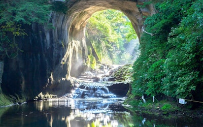
千葉県君津市エリアの絶景である亀岩の洞窟・濃溝の滝が堪能出来る動画の紹介 こちらの「[ 4K Ultra HD ] 神秘の絶景 新緑の亀岩の洞窟(濃溝の滝) - Nomizo Falls in Spring - (shot on Samsung NX1)」は、日本の千葉県君津市の清水渓流公園内にある絶景『亀岩の洞窟(濃溝の滝)』についての紹介動画です。 日本の和の雰囲気をたっぷりと感じさせる新緑の景色が魅力の亀岩の洞窟・濃溝の滝、例えるなら、アニメ『ジブリ』の舞台のような場所といったところでしょうか。 新緑に囲まれた空間で、日々の喧騒から離れて疲れを癒せる亀岩の洞窟・濃溝の滝。 今回はそちらについて、動画と共に紹介をさせて頂きます。 インスタ映え間違い無し!絶好の写真スポット! 現実とは別世界のような雰囲気を醸し出している亀岩の洞窟・濃溝の滝。 フォトジェニックな奇岩風景と場所の数々、そしてパワースポットでもあるということから、SNSでも人気の千葉県の観光名所となっています。 特に有名なのが、動画の冒頭よりご覧になることの出来るハート型の光芒です。 自然が織り成す絶景は、千葉県に来たなら必見の絶景です。 しかし注意点があります。 この光景を見ることができるのは、3月、9月のお彼岸の時期の早朝だけ。 綺麗に写真を撮るには、限られた角度の場所(いわゆる穴場)出ないといけないので、事前のリサーチが必要です。 そしてもう一つが、ホタルの乱舞を見ることが出来る長い木道と幸福の鐘です。 その年によって時期に多少の違いはありますが、大体5月~8月にかけてホタルを見ることが出来るので、千葉県君津市への観光の際には、ぜひ検討してみてください。 木道の奥には『幸福の鐘』と呼ばれる小さな鐘があります。 そこが一連のルートのゴールとされていて、記念写真を撮影される観光客も多いそうです。 亀岩の洞窟・濃溝の滝の温泉とグルメ! 自然の中を見て回れば疲れは溜まってしまうもの。 そんなときはやはり温泉とグルメで体を癒すのが良いでしょう。 亀岩の洞窟・濃溝の滝のある周辺には様々な施設があり、『濃溝温泉千寿の湯』もまたその一つです。 渓谷を見下ろしながらの温泉は、まさに至福の時でしょう。 また味覚狩り、チーズ作り体験等のアクティビティがあるマザー牧場で、ご当地グルメを堪能するのも、千葉県君津市での観光の際にはおすすめの名所です。 千葉県君津市の亀岩の洞窟・濃溝の滝魅力紹介まとめ 幻想的な雰囲気いっぱいの亀岩の洞窟・濃溝の滝。 動画でその魅力を堪能することが出来るので、ぜひご覧下さい。 東京からもアクセスしやすく交通手段が豊富で、関東圏の方は手軽に観光できることでしょう。 千葉県への観光考えている方はぜひ立ち寄られてみてはいかがでしょうか? -
 Video article 3:07
This clarity and beauty is CG! At Monet's Pond, a very popular tourist spot in Seki City, Gifu Prefecture, a beautiful, colorful scene like a painting spread out before my eyes!
Nature Living Things Travel- 9.16K plays
- YouTube
Video Introduction of "Monet's Pond," a popular tourist attraction in Seki City, Gifu Prefecture This video is titled "[4K Ultra HD] Monet's Pond - The pond, such as Monet paintings (Shot on RED EPIC)([ 4K Ultra HD ] モネの池 The pond,such as Monet paintings (Shot on RED EPIC))". Many of you may be surprised by the beauty of it. This video introduces Monet's pond, a popular tourist destination in Seki (関市, Seki shi), Gifu Prefecture, in Japan's Tokai Region. The beautiful spring in Gifu Prefecture is said to be visited by many tourists from both Tokyo and Osaka. It can be enjoyed in the video and images in this article. A variety of colorful water lilies can be seen in the spring, including yellow water lilies and more in just a 3-minute video. What Is Monet's Pond? Photo:Gold carp Monet's pond is an officially unnamed pond about the size of a tennis court, formed from the spring water around Nemichi Shrine (根道神社, Nemichi jinja) in the mountains. It was popularized through TV programs and word of mouth as the real life version of "Water Lilies" by the famous French painter Claude Monet. The beautiful Monet's Pond, has colored carp (錦鯉, Nishikigoi) swimming through its transparent waters and is great for taking Instagram photos. There are koi whose head patterns look like heart symbols in the pond, as well as gold carp for good luck. The History of Monet's Pond In 1999, the nearby flower seedling producers weeded and some carp were brought in by locals. It's purpose was not sightseeing, so it was mere chance that such natural beauty came to be. Golden Week in 2016 even attracted 3,000 tourists per day! Highlights and Recommended Seasons for Visiting Monet's Pond Photo:Monet's Pond The best time to visit Monet's Pond to experience its full beauty is during the fall when you can enjoy the magnificent view of the autumn leaves reflecting off the pond's surface. This can be seen from 1:10 in the video. We also recommend going in early May when the spring greenery is fresh or in the winter to see the beautiful snowscape. As the appearance will change considerably depending on the weather, we recommend avoiding rainy days and going at night. Access to Monet's pond is about 35 minutes from the Mino IC on the Tokai Hokuriku Expressway. You can also go to Gifu Prefecture through a sightseeing bus tour around Monet's pond and other surrounding areas. Sightseeing at Monet's Pond Photo:Grilled sweetfish Around Monet's Pond you'll find shops selling the famous "chimaki" (a dumpling wrapped in bamboo leaf), so be sure to give it a try if you get the chance! We also recommend trying the specialty eel or sweetfish (ayu cuisine) lunch in Seki. When visiting Monet's pond, you can visit the Gifu Prefecture Hundred Year Park, Kasuga Shrine, Asakurayama Promenade, Kifune Shrine, Kaore Valley, Takaga Valley, Seki Blacksmithing Tradition Museum, Koka Shrine, Horado Enku Memorial Hall, Roadside Station "Rusten Hola Do," and more. The Itadori Hydrangea Festival is held in early summer in Seki, so be sure to visit Flower Park Itatori when the hydrangeas are at their best. Summary of Monet's Pond This time, we introduced a 4K video of Monet's Pond, a pond as beautiful as beautiful as an impressionist painting. Monet's Pond is perfect for those who want to enjoy the charming scenic beauty of nature, as well as photography lovers. Book a hotel in Seki and set out on a sightseeing trip to enjoy the amazing views in the area. If you like the artistic scenery of Monet's Pond, we recommend visiting Monet's Garden in Kitagawa, Kochi Prefecture. The landscape of Monet's Pond changes depending on the weather. We recommend that you check the weather forecast on the day you plan your sightseeing trip so that you aren't disappointed because you weren't able to see it at its most beautiful. ◆Monet's Pond◆ 【Address】〒501-2901 1643-17 Itadori Kamigase, Seki City, Gifu Prefecture 【Access】About 35 minutes from Tokai Hokuriku Expressway Mino IC 【Closures】None 【Average time spent here】1-2 hours 【Parking】Available. Up to 200 standard vehicles 【Telephone No】0581-57-2111 【Admission fee】None 【Notes】Feeding the fish is prohibited The transparency of the pond changes depending on the weather. 【Tripadvisor】Monet's Pond https://www.tripadvisor.com/Attraction_Review-g1019693-d12479612-Reviews-Monet_s_Pond-Seki_Gifu_Prefecture_Tokai_Chubu.html -
Video article 5:19
Lake Saroma in northeastern Hokkaido, Japan, "Acheilognathus (Corallium japonicum)" turns the whole area red. A 4K video of the great outdoors at its best!
Nature Travel- 66 plays
- YouTube
Glasswort, the Bright Red Plant Covering Lake Saroma in Hokkaido This video, titled " JG 4K Hokkaido|Glasswort Around Lake Saroma|Hokkaido Sea Asparagus" (JG 4K 北海道 サロマ湖周辺のアッケシソウ(サンゴソウ) Hokkaido Sea Asparagus), was uploaded by " JAPAN GEOGRAPHIC." Hokkaido is one of the most popular tourist destinations in Japan, attracting many foreign tourists every year thanks to its natural beauty. "In this 4K video, you can see the rare carpet of sea asparagus at Lake Saroma in Hokkaido, which is known as "Japan's best red carpet." Glasswort is a saltwater plant that grows in salt marshes that are subject to the ebb and flow of the tides. It is a salt-tolerant, edible plant that grows into a cylindrical shape 10 to 35 cm tall. As glasswort, an annual plant, grows, its flesh stores a large amount of salt, giving it a firm texture and salty taste. The leaves and stems are edible, and it is called sea asparagus because of its resemblance to asparagus, and is used in cooking in parts of Europe. Lake Saroma is the largest brackish lake in Japan and faces the sea, making it ideal the ideal environment for sea asparagus to grow. The Sea Asparagus at Lake Saroma in Hokkaido Photo:Sea asparagus Salicornia Europaea, this variety of sea asparagus, has been registered as an endangered species. Lake Noto in Abashiri, Hokkaido, is home to one of the largest colonies of sea asparagus in Japan, which is artificially cultivated with a tractor to suppress the growth of other halophytes (salt-tolerant plants). Lake Saroma, shown in the video, is one of the few areas where sea asparagus is cultivated. In Japanese the plant is often called "Sango-so" (サンゴ草: lit. "Coral grass") because its tips are red and resemble coral. You can see a close-up shot of the coral-like glasswort at 3:13 in the video. Tasting the Sea Asparagus Grown in Hokkaido's Lake Saroma Photo:Sea asparagus Sea asparagus is a plant that tastes salty when eaten raw, so it is commonly boiled and eaten as is. It is also delicious when added to pasta, stews, and other boiled dishes. In recent years, it has been distributed in supermarkets across Japan, so be sure to try it if you have the chance. It is rich in minerals and amino acids such as magnesium, which Japanese people tend to deficient in, and the extract of sea asparagus is so nutritious that it is used as an ingredient in many supplements. Summary of Sea Asparagus at Lake Saroma in Hokkaido Source :YouTube screenshot Lake Saroma in Hokkaido is part of the Abashiri Quasi-National Park, and is famous as an area that cranes fly over every year in early September when the autumn leaves begin to change color. You can see one of these cranes at 3:17 in the video. Sango-so Matsuri (能取湖さんご草祭り) a sea asparagus festival at Lake Saroma is held from early to mid-September, and a sightseeing bus called "Dollymint Okhotsk-go" (ドリーミントオホーツク号) operates there. As it is not a place with convenient access, many tourists visit by rental car, so be sure to research details on parking and other events in the area. 【TripAdvisor】Lake Saroma https://www.tripadvisor.com/Attraction_Review-g1120894-d1384194-Reviews-Lake_Saroma-Saroma_cho_Tokoro_gun_Hokkaido.html -
Video article 1:39
Baikamo – Flowers That Bloom Only in the Clearest Water. Beautiful Underwater Images of the Summertime Flower
Nature Travel- 191 plays
- YouTube
Baikamo Blooming on the Takimi River in Hyogo Prefecture: Video Introduction This video, titled "Baikamo|A Flower Only Found in Japan [Shinonsen] 4K" (バイカモ 日本固有種 【新温泉町】4k), was uploaded by "e production.com" (e映像制作.com). Have you ever heard of the plant baikamo? In this article, we'll introduce an underwater flower that blooms in the Takimi River in Shinonsen, Hyogo. Be sure to check out the video to see the beautiful baikamo blooming in the clear stream. Baikamo – A Look at the Flower Blooming on the Takimi River in Hyogo, Japan Source :YouTube screenshot From the beginning of the video, you can see baikamo growing as birds chirp and the gentle sound of the river plays in the background. The video is very striking, as if it were shot from a bird's eye view. The location shown in the video is Baikamo Park. There are not many areas in Japan where baikamo can be found in such abundance. Baikamo is a plant that grows in tall mountains where the water is very cold, so it's rare to see it growing in clusters. Unfortunately, the baikamo colony on the Takimi River began to shrink in size around 2017, and as of 2022, not many baikamo can be seen anymore. Baikamo, a Flower that Blooms Under Water Photo:Baikamo Baikamo is a species endemic to Japan. The baikamo, which blooms along the Takimi River in Shinonsen, belongs to the buttercup family, Ranunculaceae, and has the scientific name of Ranunculus Kazusensis Makino. In floriography (the language of flowers) its meaning is "Happiness will come." Just as the language of flowers suggests, the small, pretty flowers blooming on the surface of the water make people happy just by looking at them. There is also a type of baikamo called ginkgo baikamo, which can be seen in some areas of Japan. This flower blooms from early summer to early fall, with white flowers 1-2 cm in diameter. The flowers resemble plum blossoms, and because of this, baikamo is often written with the kanji 梅花藻 (梅, Bai "Plum"; 花 ka "Flower"; 藻 mo "Algae"). It's a perennial flower that grows underwater and is characterized by its evergreen nature. It is also edible as a wild plant. Where Can Baikamo Be Found in Japan? Photo:The Jizo River, Awai, Shiga The baikamo featured in this video can be seen in Japan's Kinki region, such as the Jizo River in Awai, Shiga, and Kamikawa, Hyogo. Other locations include Echizen, Fukui; Mishima Baikamo Park (三島梅花藻公園), Shizuoka; Chokeiji Temple (長慶寺) in Tsuru, Yamanashi; and the Shimizu River in Konan, Fukushima. There is also a baikamo colony in Eniwa, Hokkaido. Summary of Baikamo, an Aquatic Plant That Blooms Only in Clear Streams Baikamo is an aquatic plant that blooms only in clear streams rich in nature. It's a pity that the number of baikamo has been decreasing due to various climate and environmental changes. However, there is good news from the Shimizu River in Tamba, Hyogo. The number of baikamo had been rapidly decreasing due to the decrease in water flow caused by the proliferation of weeds, but thanks to preservation activities by local residents, the baikamo population has been restored. It would be nice to see baikamo blooming beautifully again in the Takimi River like in the video. 【TripAdvisor】Baikamo Park https://www.tripadvisor.com/Attraction_Review-g1121310-d8368832-Reviews-Baikamo_Park-Shinonsen_cho_Mikata_gun_Hyogo_Prefecture_Kinki.html -
Video article 3:27
The World of the Ghibli Film "Castle in the Sky" Has Spread To Aso, Kumamoto Prefecture! With Its Rich, Unexplored Landscape and Spectacular Scenery, Aso Is a Popular Spot for Drives!
Nature- 275 plays
- YouTube
Introducing Aso in Kumamoto Prefecture! This video, titled “Best Views of Japan – Unexplored|Searching for Laputa in Aso, Only To Find That Aso Is Laputa!” (日本一の絶景 秘境 ラピュタの道を阿蘇に探しに行ったら、阿蘇の全てがラピュタだった), was released by “Drone RangerMiura.” It introduces the beautiful summer scenery of Aso, Kumamoto Prefecture, in Japan’s Kyushu region. The scenery of Aso Gogaku (阿蘇五岳, The Five Peaks of Mt. Aso), shot via drone, looks just like the world of the Studio Ghibli movie "Laputa: Castle in the Sky." In the Aso area, there are sightseeing spots called "Laputa Road" (ラピュタの道) and "Laputa Modoki" (ラピュタもどき), which have been attracting attention from people who enjoy going on casual drives to enjoy scenic locations. A Look at Laputa Road, Shown in the Video Photo:Aso, Kumamoto Prefecture The official name of “Laputa Road” is “Aso City Road Kario Main Line” (阿蘇市道狩尾幹線). From Prefectural Road 149 to Prefectural Road 339 (a.k.a. Milk Road), which runs over the outer rim of the mountain, a mysterious phenomenon creates a sea of clouds, allowing for breathtaking views. At 0:33 in the video, cows and horses are shown, and at 1:05, a beautiful waterfall can be seen. In the Aso area, you can go for a walk and discover the unexplored natural scenery, as well as enjoy activities, such as horseback riding and stargazing. Popular Spots in the Aso Area Introduced in the Video Photo:Daikanbo Lookout on Mt. Aso, Kumamoto Prefecture There are many spots in the Aso area where you can enjoy superb scenery, such as the Laputa Road Observatory and the Daikanbo Lookout (大観峰展望台) on Daikanbo, one of the peaks of the Northern Outer Rim of Mt. Aso. If you visit the Aso area to view the scenery, be sure to stop by the observatory! There are also many park facilities, such as the Oku-Aso Fruit Garden (奥あそフルーツガーデン), Rakunoh Mother's Aso Milk Ranch (阿蘇ミルク牧場), and Aso Farmland (阿蘇ファームランド). Be sure to check out Aso Shrine (阿蘇神社) as well! Points To Note When Sightseeing in the Aso Area Photo:The Nanatsugama Caves, Kumamoto Prefecture In the Aso area, there are many places of interest, such as the Nanatsugama Caves in Saga Prefecture's Karatsu, which is designated as a national natural monument, and Kusasenrigahama. However, due to risk of eruption, the area around the crater has been placed on alert and entry is now restricted. The 2016 Kumamoto earthquakes also caused some road closures in the Aso area. When visiting Aso, be sure to pay attention to observation information and alerts/warnings. Summary of the Aso Area Photo:Mt. Aso, Kumamoto Prefecture Aso is one of the most popular tourist spots in the Kyushu area thanks to the natural beauty of the mountains and sea. If you're looking to experience what it's like to be in the world of "Castle in the Sky," then you should definitely drop by Aso for a visit! 【Tripadvisor】Mt. Aso https://www.tripadvisor.com/ShowUserReviews-g298212-d320703-r710938456-Mt_Aso-Kumamoto_Prefecture_Kyushu.html -
Video article 3:35
Shirasaki Coast in Wakayama Prefecture, Called the "Aegean Sea of Japan," Is Just Like a Painting! Introducing the Charms and Activities of Shirasaki Coast!
Nature- 163 plays
- YouTube
Introducing Shirasaki Coast in Wakayama Prefecture! This video, titled "Shirasaki Coast (Wakayama) A Beautiful Scenic Location Called the Aegean Sea of Japan" (白崎海岸(和歌山)日本のエーゲ海と称される絶景スポット), was released by "K Japan Traveler." Shirasaki Coast in Wakayama prefecture, which has a magnificent view on Instagram, was selected as one of the Top 100 Beaches of Japan, and in 2009, it was also selected as one of the Top 100 Landscapes of the Yomiuri Shimbun. Many tourists visit the beach throughout the year, where the contrast between the blue of the sea and sky and the pure white of limestone and sandy beaches is attractive. The History and Highlights of Shirasaki Coast Photo:Shirasaki Coast, Wakayama Prefecture Shirasaki Coast is the sea of the Shirasaki Coast Prefectural Natural Park in Yura, Hidaka District, Wakayama Prefecture, and, as you can see at 0:33 in the video, is characterized by the white limestone surrounding it. Geologically, limestone is said to have come from the Permian Period in the latter half of the Paleozoic Era, more than 200 million years ago. From spring to summer, a large group of black-tailed gulls fly to Shirasaki Coast in Wakayama prefecture, which is rich in nature, as you can see from 3:03 in the video. The marine park is also known for its daffodils. Things To Do at Shirasaki Coast in Wakayama Prefecture Photo:Shirasaki Coast, Wakayama Prefecture We recommend enjoying swimming, fishing, and Shirasaki cruise activities around Shirasaki Coast in Wakayama prefecture. There are also diving spots and diving pools nearby. From Shirasaki Manyo Park, we recommend enjoying the view of the strange rocks "Tatego" and "Oobae," which are the symbols of Shirasaki Coast. Also, stop by Koukokuji Temple, the Shellfish Exhibition Hall, the Park Center, Shirasaki Marine Park Observatory, and Totsui Limestone Cave. Dining and Lodging at Shirasaki Coast Photo:The Starry Skies of Shirasaki Marine Park, Wakayama Prefecture Around Shirasaki Coast, there are many restaurants and cafes where you can eat seafood dishes such as Shirasu-don on a low budget as well as the famous Shirasaki curry. In addition, there's Roadside Station Shirasaki Ocean Park where you can buy souvenirs, and hotels that are ideal for accommodation, so plan your trip carefully! Summary of Wakayama Prefecture's Shirasaki Coast As you can see in the video, the charm of Shirasaki Coast is that you can enjoy the spectacular blue and white scenery. When the sun sets, you can see a soothing view that you won't find during the day. Be sure to check out the business information and regular holidays for the Shirasaki Marine Park campsite and the surrounding facilities before visiting for sightseeing. ◆ Introduction to Shirasaki Coast ◆ 【Address】Take a bus from JR Kii-Yura Station and get off at Shirasaki Nishi, and walk 1.5 km. 【Parking】Free Parking Available 【Tripadvisor】Shirasaki Marine Park https://www.tripadvisor.com/Attraction_Review-g1121347-d1385202-Reviews-Shirasaki_Ocean_Park-Yura_cho_Hidaka_gun_Wakayama_Prefecture_Kinki.html -
Video article 3:03
The Niyodo River in Shikoku Is Famous for Having the Clearest Waters of All Rivers in Japan! Enjoy the Mystical World of the Crystal Clear Waters Coined "Niyodo Blue"!
Nature- 222 plays
- YouTube
Niyodo River: The Best Water Quality in Japan! This video, titled "[4K] 仁淀ブルー:奇跡の清流 仁淀川(高知県 仁淀川水系)Niyodo River,the best water quality river in Japan.," was created by "AQUA Geo Graphic." When asked about famous rivers in the Shikoku region, most people picture the Shimanto River (四万十川, shimantogawa), but did you know there is an even prettier river in the area? I'm of course referring to the Niyodo River. As the third largest river in Shikoku, after the Shimanto River and Yoshino River (吉野川, yoshinogawa), it ranks number one year after year as the river with the best water quality in Japan. As you can see in the video, the crystal clear water of the Niyodo River is absolutely stunning and has been given the name "Niyodo Blue" after its mystical blue color. In the video, you can enjoy viewing the river from both above and below the surface of the water! Serpent Sanctuaries and Instagrammable Spots Near the Niyodo River Photo:Niko Deep, Kochi Prefecture Mt. Ishizuchi's (石鎚山, ishizuchisan) Omogo River in Ehime Prefecture (愛媛県, ehimeken) is the main water source for the Niyodo River and the streams that run through the valleys of Kochi Prefecture (高知県, kouchiken). Niyodo River is 124 kilometers long and has a surface area of 1,560 square kilometers. The river runs through mainly mountainous regions and the combination of both the beautiful natural surroundings and stunning blue color of the river makes the area very picturesque. From 1:50 in the video, you can see the basin of "Nikobuchi" (にこ淵), which is thought to be the home of the legendary eight-headed serpent Yamata no Orochi. On a sunny day during the hours of 11 am and 3 pm, the light shines directly into the pool and the blue color of the river is even more prominent. We highly recommend visiting Nakatsu Gorge (中津渓谷, nakatsukeikoku) and Yasui Gorge (安居渓谷, yasuikeikoku) during the fall to see the beautiful scenery. There are many beautiful spots along Nakatsu Gorge, such as Uryu Falls (雨竜の滝, uryuunotaki), Momiji Falls (もみじだき) and Ryugubuchi (竜宮淵). The special rocks called "Ishibashira" (石柱) are another great sightseeing spot. The pool of water known as "Suishobuchi" (水晶淵) along Yasui Gorge changes color from blue to green depending on the season and time of day. The contrasting colors of the fall foliage and the river attracts many visitors and the area has become a very popular tourist destination. In the second half of the video, from 2:09, you can see some of the low-water crossings found along Niyodo River. A distinguishing feature of these types of bridges is that they have no sides or guard rails, which allows them to blend easily into the surrounding nature creating a beautiful landscape. The Niyodo River Is Popular Among Both Locals and Tourists! Photo:Niyodo River, Kochi Prefecture In recent years the number of tourists visiting the Niyodo River has increased dramatically, but the river is still just as popular among the locals. The Niyodo River area has a population of approximately 110,000. In the middle reaches of the river, there's the multi-purpose Odo Dam (大渡ダム) and facilities for flood control and power supply development, which support the lives of people living in harmony with the Niyodo River. There are also several campsites in the area for those who'd like to spend the night in the beautiful outdoors. There are many fun activities to take part in, such as canoeing and rafting or you can simply go for a swim. There is also a stone skipping competition held here each year. The locals can often be seen playing in the river. In 2002, the Niyodo River was the most visited river in Japan. Not only is it the most beautiful river in Japan, it's also the most loved river by its locals. Summary of the Niyodo River Photo:The Niyodo River and a low-water crossing, Kochi Prefecture The mystical blue water of the Niyodo River captivates all who look upon it. The majority of the river is surrounded by mountains making it fairly difficult to access via public transportation. We recommend renting a car or taking a trip to the river by bike! There is a roadside station near the river with hot spring facilities where you can also spend the night, a perfect place to relax after a long day of sightseeing. For those who don't have a valid driver's license in Japan but still wish to visit the Niyodo River, please check out the Niyodo River Tourist Association (仁淀川観光協会, niyodogawa kankou kyoukai) website for more information on how to access the river via public transport (※Unfortunately the website is only in Japanese). Some of the roads from the car park to the spots introduced in the video can be slippery so please be careful when walking. If you still haven't yet, be sure to enjoy the mystical world of the beautiful, blue Niyodo River in the video. 【Tripadvisor】Niyodo River https://www.tripadvisor.com/Attraction_Review-g298233-d10383500-Reviews-Niyodo_River-Kochi_Prefecture_Shikoku.html -
Video article 6:38
Mishakaike Pond, Full Of Fresh Greenery and Nature! The Locals Have Loved This Beautiful View for Years, and It Doesn't Leave You With Any Feelings Other Than Excitement!
Nature- 208 plays
- YouTube
This video, titled "Fresh Greenery at Mishakaike Pond "'A Place I Want to Visit Before I Die! Scenery of Japan" Okutateshina|Japan's Mishakaike Pond in Summer|Downconvert 4K Video to 2K|Natural Landscape Photography" (新緑の御射鹿池「死ぬまでに行きたい!日本の絶景」奥蓼科 Japan Mishaka pond of summer Downconvert 4k shot video by 2k 自然風景映像), was released by "Yatsugatake21_4K_Japan." This video introduces Mishakaike Pond, which was the motif of the famous Japanese painter Kaii Higashiyama's work. Mishakaike Pond in Chino City, Nagano Prefecture was actually created at the beginning of the Showa Period (1926-1989) as an agricultural reservoir, and has now been selected as one of Japan's Top 100 Ponds by the Ministry of Agriculture, Forestry and Fisheries. The beautiful scenery, which can be called a true mystery of nature, is unforgettable, and it is one of the most famous sightseeing spots in Japan that you should be on your bucket list. Please enjoy the beautiful scenery of Mishakaike Pond in the video. -
Video article 2:13
Zao - Where Fantastic Ice Trees Stretch as Far as the Eye Can See. Referred to as "Ice Monsters" This Destination in Yamagata Prefecture Is Very Popular Among Foreign Tourists
Nature- 113 plays
- YouTube
自然が生み出す絶景「蔵王の樹氷」をご紹介! 日本にはさまざまな名所があります。 その中でも幻想的な景色を楽しめる場所に旅行したいと思っている方は多いと思います。 そのような方々に、山形県の蔵王の樹氷をおすすめします。 この記事では、「Saha Entertainment TV」が公開した「[4K] 絶景蔵王の樹氷 Amazing Ice Monsters」をもとに、日本のおすすめの観光地である蔵王の樹氷の魅力や、おすすめのインスタ映えスポットの情報などを説明します。 「蔵王の樹氷」が生み出す自然の美しさ 蔵王の樹氷は、山形の蔵王連峰にある植物に雪が凍り付き、固まったものです。 東北地方の奥羽山脈(飯豊連峰、朝日連峰、月山、鳥海山など)でしか確認されておらず、とても珍しい自然美を堪能することができます。 見ごろは、1月の下旬から3月の上旬です。 この時期には樹氷のライトアップイベントも行われているので、夜の幻想的な蔵王の樹氷を楽しめます。 このように、蔵王の樹氷は他では見ることができない美しい絶景を楽しめるので、自然を楽しみたい方にはおすすめの観光地です。 「スノーモンスター」や「アイスモンスター」とよばれる蔵王の樹氷を思う存分、鑑賞しましょう。 日本の観光地である「蔵王の樹氷」は幻想的な景観を楽しめる 日本の観光地である蔵王の樹氷は、幻想的な景観を楽しむことができます。 昼の太陽の光によるデイライト樹氷は、自然の光と特徴的な形の樹氷が融合して、少し変わった美しい風景を楽しむことができます。 夜のライトアップでは、色彩が鮮やかな光によって樹氷が浮かびあがり、幻想的な景色を堪能できるでしょう。 蔵王の樹氷は、昼と夜で幻想的な景色を見ることができる素晴らしい場所です。 日本の観光地である「蔵王の樹氷」を見るのにおすすめのエリア 日本の観光地である蔵王の樹氷は、自然の景色を満喫できるスポットがたくさんあります。 温泉街からのれるロープウェイは、大きな窓から樹氷を見ることができるのでおすすめです。 ゆったり座りながら鑑賞できるのもポイントです。 ロープウェイの山頂駅も人気スポット。 駅から降りた瞬間に広大な樹氷が目の前に広がっています。 展望台では樹氷原を一望できるので、ぜひ訪ねてみてください! 絶景「蔵王の樹氷」のまとめ 他では見ることができない蔵王の樹氷。 ぜひ現地でアイスモンスターと呼ばれる絶景をご覧になってみてください。 その幻想的な景色と迫力を思う存分、楽しみましょう! -
Video article 2:14
Kamiike Pond Is a Mysterious Pond Surrounded by the Sea, Yet Filled With Freshwater Carp. Enjoy the Beauty of This Tourist Destination in Shizuoka, One of the Seven Wonders of Izu, Whose Mysteries Have Yet to Be Solved!
Nature- 278 plays
- YouTube
Aerial video introduction of "Ose Myojin no Kamiike" in Numazu City, Shizuoka Prefecture This video, “絶景空撮 大瀬崎 神秘の自然と信仰の岬 - Aerial view of Cape Osezaki - Secret nature and religious cape -」,” is an aerial video of Cape Osezaki’s Kamiike Pond, located in the bayside of Numazu city, Shizuoka prefecture, produced by “FUJISAN DRONE BASE.” Osezaki is a cape in Numazu city, Shizuoka prefecture, extending into Suruga Bay, and is also called the Ose no Kami Pond of Ose Myojin, or Biwa Island. As shown at 0:50 in the video, you can see the great view of Mt. Fuji over the sea from Osezaki Kamiike Pond. What Kind of Sightseeing Spot Is Osezaki Kamiike Pond? Photo:Osezaki Kamiike, Numazu City, Shizuoka Prefecture As seen in the video at 0:15, Osezaki features the beautiful Kamiike Pond, with the longest part of the pond being about 100 meters wide. Osezaki’s Kamiike Pond is called an "unexplored area," "mysterious spring," and is a mysterious spot considered one of the seven wonders of Izu. Although Ose Myojin’s Kamiike Pond is located at the tip of a cape, it's a fresh water pond, and fresh water fish, such as carp, call this pond home. It is said that Mt. Fuji’s underground water pours into Ose Myojin’s Kamiike Pond, but the mystery of Ose Myojin’s Kamiike Pond has yet to be solved. The water quality and depth are also unknown. Let’s Visit Ose Shrine in Osezaki! Photo:Osezaki and Ose Shrine Around the Osezaki Kamiike Pond are many large juniper trees with thick foliage. Osezaki’s juniper forest has been designated a Natural Monument. Hikitechikara no Mikoto (Ose Shrine) seen in the video at 1:14, is located at the peak of Osezaki, with an elevation of approximately 10m, and is called the protectorate god of the sea. Other highlights include a sacred tree said to be 1,500 years old, a pair of iron geta (sandals) dedicated near the torii gate, and a strange fan made of tengu leaves derived from the legend of tengu. Sightseeing Around Osezaki’s Kamiike Pond Photo:Clownfish Around the scenic Osezaki is the Ose beach, which is one of Japan’s “Top 100 Beaches.” Spending time listening to the waves and taking in the sunset is very relaxing. Osezaki is also popular as a diving spot, and many divers visit here during the on season. Osezaki is also known as a fishing spot, but collecting animals and plants around Kamiike Pond is prohibited by the Cultural Assets Preservation Act, so be careful not to break any laws. Summary of Ose Myojin’s Kamiike Pond Source :YouTube screenshot Shizuoka prefecture’s Osezaki Kamiike Pond area, introduced in the video, is a nice Instagram spot where you can see the beautiful sea and Mt. Fuji. There are many sightseeing spots in Izu, book a hotel nearby and visit Osezaki. In the spring time, cherry blossoms bloom nearby as well. We also recommend participating in a tour visiting Ose Myojin’s Kamiike Pond and the nearby area. ◆Hikitechikaranomikoto Shrine (Ose Shrine) General Information◆ 【Address】329, Nishiura Enashi, Numazu city, Shizuoka, ZIP 410-0244 【Access】80 minutes by bus from JR Numazu Station 【Admission fee】100 JPY 【Hours】8:30-17:00 【Parking】Available 【Telephone】055-942-2603 【Tripadvisor】Ose Myojin’s Kamiike Pond https://www.tripadvisor.com/Attraction_Review-g1019668-d1313552-Reviews-Ose_no_Kami_Pond-Numazu_Shizuoka_Prefecture_Tokai_Chubu.html -
Video article 6:34
Unkai Terrace - Experience a Sea of Clouds Flowing Like the Ocean! Powerful Views You Won't Find in Everyday Life. It's Truly a Sight to Behold!
Nature- 83 plays
- YouTube
This video, titled "[Hoshino Resort Tomamu] Unkai Terrace - Sea of clouds flowing into the sea of clouds (Unkai Terrace)" (【星野リゾート トマム】雲海テラス 流れ込む雲海<絶景> Unkai Terrace), was released by Hoshino Resort Tomamu (official). This video introduces Unkai Terrace at the luxury resort "Hoshino Resort Tomamu" in Hokkaido. Unkai Terrace is a superb spot at the Hoshino Resort Tomamu in Hokkaido where you can see the sea of clouds from above, and the overwhelming view of the grandeur of nature is nothing short of breathtaking. The probability of seeing the sea of clouds itself is low, but it is a view that makes you want to see it at least once in person. This video shows the actual view of the sea of clouds from Unkai Terrace, so if you're interested, be sure to check it out. -
Video article 4:31
Genbikei Gorge, a Historically Famous Valley in the Midst of Nature! Feel the Excitement in a Land Full of Natural Beauty!
Nature- 46 plays
- YouTube
This video, titled "Drone Footage|Ichinoseki City, Iwate Prefecture|Genbikei Gorge" (ドローン撮影 岩手県一関市 厳美渓), was released by "Iwate Drone Movies" (岩手ドローンムービー). This video introduces Genbikei Gorge, which has been designated a place of scenic beauty and a natural monument. Genbikei Gorge in Ichinoseki City, Iwate Prefecture is the name of a section of ravine in the Iwai River and has long been a popular scenic spot. It is said that Date Masamune, a famous military commander in the Warring States period of Japan, would have praised the valley, and many tourists visit the valley to feel the history of Japan. In this video, you can see the overwhelming grandeur of nature in Genbikei Gorge from the sky, so be sure to check it out. -
Video article 1:10
Spectacular Views for Only Two Weeks of the Year! A Dragon's Eye on the Surface of the Lake in Kagami-Numa, Akita Prefecture
Nature- 43 plays
- YouTube
This video, titled "A Dragon's Eye That Appears at Hachimantai in Early Summer: Akita-Iwate Border [nippon.com]" (初夏の八幡平に現れる「ドラゴンアイ」:秋田・岩手県境 | nippon.com), was released by "nippon.com" Hachimantai, which lies near the border of Akita and Iwate prefectures, is a mountain range in the northern part of the Ou Mountains dotted with rolling lakes and swamps at 1,600 meters above sea level. One of the lakes, Kagami-numa in Senboku City, Akita Prefecture, is called "Hachimantai Dragon Eye" because the snow on the surface of the lake melts into a doughnut shape, making it look like the eye of a dragon. The dragon's eye is only visible for two weeks, and heavy equipment is required to climb the mountain during the snowy season. Seeing a scene like the one in this video is extremely rare, so it's a must-see! -
Video article 1:26
Chichibu Sea of Clouds" is rapidly gaining popularity! A fantastic video of the night view and sea of clouds in Chichibu City, Saitama Prefecture. 1 minute and 26 seconds later, your common sense will be overturned!
Nature Travel- 484 plays
- YouTube
Chichibu Cloud Sea and Night View" Video Introduction in Chichibu, Saitama Prefecture This video, titled "Chichibu Sea of Clouds/Time Lapse Video(4K-ProRes)2016.11.21" (秩父雲海 / Sea of Clouds - JAPNA タイムラプス動画 (4K-ProRes) 2016.11.21), was released by HASHIZUKA DESIGN STUDIO. The sea of clouds is a mysterious phenomenon in which a thick fog is generated near the surface of the earth, creating what looks like a sea of clouds when viewed from a high altitude. In Japan, Takeda Castle in Hyogo prefecture and Hoshino Resorts Tomamu in Hokkaido are famous for this, but did you know that this phenomenon also occurs in Chichibu, Saitama, a place close to Tokyo? This video introduces a colorful night view and the wondrous scenery of the sea of clouds in Chichibu city in 1 minute and 26 seconds. The beauty of Chichibu's sea of clouds is beyond imagination! Get ready to have everything you thought you knew about the beauty of nature thrown out the window! The Chichibu Sea of Clouds - Popularity, Forecasts, and the Conditions To See It Photo:Chichibu sea of clouds The Chichibu sea of clouds, which can be seen in Saitama Prefecture, is rapidly increasing in its popularity online. It's in a good location, about 90 minutes from Tokyo, and has become widely talked about for its amazing night views popular among instagrammers. It's so popular that, in recent years, tours with the theme "Sea of Clouds" are being held as well. As you can see from 0:32 in the video, what makes Chichibu's Sea of Clouds special is that the fog fills the Chichibu basin, covering the city. The lights of the factories and residential areas in the city of Chichibu, gives a faint color to the sea of clouds, creating a fantastic view. The conditions for seeing the Chichibu sea of clouds are as follows. ◇Season: Spring and Autumn - High probability in April and November ◇Time: Dawn-Early morning ◇Weather: If it was raining (or snowing) the day before, and sunny on the day of ◇Wind speed: If wind speed is 1m (~2.2 mph) or less and very weak ◇Humidity: If the humidity is very high, around 100% With these conditions in mind, it's extremely difficult to stare at the weather forecast and information sites of Saitama Prefecture hoping for the day to finally come. If you still want to witness some of the best moments of the Chichibu Sea of Clouds, we recommend the sea of clouds forecast on Twitter. They transmit the probability of the sea of clouds occurring in Chichibu and are proud of their reliable accuracy rate. In addition, you can check the current state of the sea of clouds with the "Chichibu Sea of Clouds Live Camera" on the Chichibu Official Website, so you see the beautiful sea of clouds whenever it occurs. That being said, nothing beats actually experiencing the Chichibu Sea of Clouds in person. In the next paragraph, we'll introduce some recommended viewing locations. Chichibu Muse Park - Stay Overnight and Enjoy the Sea of Clouds! Photo:Chichibu Muse Park Chichibu Muse Park is the best place for those looking to see the Chichibu Sea of Clouds. Chichibu Muse Park is a park managed by Saitama Prefecture and the Chichibu Municipal Government and is a popular tourist destination that is also known for firefly viewing. There are two observatories in the park, the "Observatory" and "The Hill of Departure." The video was taken from the observatory in Chichibu Muse Park at an altitude of 363m. The H-shaped structure that can be seen from 0:52 is Chichibu Bridge. Chichibu Muse Park is a park operated by Saitama Prefecture and Chichibu City, and is a popular tourist attraction known for its fireflies. The fantastic sea of clouds can be seen from the park's two observatories, Tabidachi no Oka (The Hill of Adventures) and the 363-meter-tall observation deck. The early morning hours in November, when the sea of clouds is at its peak, can be crowded, but if you stay at the PICA Chichibu lodging facility in the park, you should have no problem seeing it. Here, you can enjoy the Chichibu Sea of Clouds while camping under the starry sky. There's free parking and it's only 20 minutes from Seibu Chichibu Station. Transportation access is also very convenient. Summary of the Chichibu Sea of Clouds Photo:Chichibu Sea of Clouds Here we introduced the Chichibu Sea of Clouds, the conditions for it to occur, recommended viewing locations, and more! In the city of Chichibu, you can also see the Chichibu Sea of Clouds at Minoyama Park, which is one of the best night views in Japan, as well as Hitsujiyama Park, from which you can enjoy the view from the same height as the sea of clouds. You can also see the sea of clouds from Mitsumine Shrine, a known power spot. Every place for viewing the Chichibu Sea of Clouds has its own charm, but night view of Chichibu Muse Park, shown in the video, is absolutely breathtaking. Be sure to check out the video to see a serene view of Chichibu's sea of clouds. -
Video article 1:16
I felt my heart being absorbed by the mysterious and beautiful scenery of the autumn leaves video of Norikura Kogen in Matsumoto City, Nagano Prefecture, a popular tourist destination, in the beautiful brocaded autumn!
Nature Travel- 167 plays
- YouTube
Norikura Kogen" in Matsumoto City, Nagano Prefecture, Autumn Foliage Video Introduction This video, titled "Autumn Colors in Japan|Autumn at Norikura Kogen" (日本の紅葉 Autumn Colors in Japan 乗鞍高原の秋), was uploaded by "beaphoto1. The video introduces the spiritual and ephemeral autumn scenery of Norikura Kogen (Norikura Highlands), a place visited by large numbers of people every year for its legendary autumnal colors. The beauty on display is such that you'll forget all about time for the entirety of the 1-minute video. We're sure that when you're done watching you'll be itching to visit Norikura Kogen! Where is Norikura Kogen? Basic Tips for Sightseers Photo:Autumn leaves at Norikura Kogen, Nagano Prefecture Located in Matsumoto, Nagano in Japan's Koshin'etsu region, and on the eastern side of the Northern Alps' southernmost area, the Norikura Kogen highlands are a popular sightseeing spot, and are lively in all seasons, with visitors making the trip for a variety of reasons. In the summer, you can escape the heat while camping or stay at one of the bed and breakfasts in the area. As summer gives way to fall, mountain climbing becomes a popular pastime, and in the winter, skiing and other winter sports can be enjoyed here. Also, the hot springs bursting forth from several locations in the area can be enjoyed no matter the season. Furthermore, if you're looking to get your fill of the great outdoors, no trip to Japan's Northern Alps would be complete without a visit to Norikura Kogen Holiday Village (休暇村乗鞍高原, Kyuka-mura Norikura Kogen). Situated 1600m above sea-level, it's perfect for stargazing and early morning walks, and there are even activities for enjoying nature with fellow travelers that anyone can participate in at their leisure. The views of the night sky here are truly unforgettable. Take your time and enjoy the boundless nature of Japan's Northern Alps at Norikura Kogen Holiday Village! When Is the Best Time to See the Autumn Foliage at Norikura Kogen? Photo:Ichinose Park, Norikura Kogen Autumn means autumn leaves, and the best time to see those at Norikura Kogen is from mid-late October. During this period, sightseers converge on the area for a glimpse of Norikura Kogen's autumn foliage. At one of the most famous spots, Ichinose Park (一の瀬園地, Ichinose-enchi), the reflection of Mt. Norikura (乗鞍岳, Norikura-dake) on the water's surface contrasts with the autumn leaves to create a spiritual atmosphere. [Video] 0:10 - Autumn Leaves and the Reflection of Mt. Norikura Even the more indoorsy people will find themselves enjoying hiking around Ichinose Park. Take a leisurely walk and admire the white birch forests, Zengoro Falls, Organ Bridge (オルガン橋, orugan-bashi) which spans the mountain stream, and the seasonal flowers that can be found in the area. The giant maple tree shown in the video is popular with photographers as a superb photo spot, so don't forget your camera! [Video] 0:31 - Giant Maple Tree Norikura Skyline/Echo Line aka Paradise in the Sky Photo:Norikura Skyline, Korikura Kogen You'll feel like you're coasting through the sky at Norikura Skyline/Echo Line. The word "Skyline" makes it sound like somewhere you'd go by car, but since this is a place to enjoy nature as well as gorgeous views while gliding through the sky, personal vehicles are prohibited in order to protect the environment and prevent traffic. If you're planning to visit by car, you'll need to switch to a bus at some point. For further details, check the Hida-Norikura Tourism Association's (飛騨乗鞍観光協会, Hida Norikura kanko kyokai) home page. Summary of Sightseeing at Norikura Kogen Norikura Kogen is brimming with fantastical views, including autumn leaves and giant maples, and has come to be known as a Paradise in the Sky. It's great for instagrammers and photographers alike, too. Why don't you add Norikura Highland to the candidate sites when you travel to Nagano? Norikura Kogen is also rife with facilities, including day-trip hot spring facilities, but there's so much to see and do that we encourage you to stay the night and take your time enjoying the superb views. So let go of some of that stress and charge your batteries with the help of Mother Nature. [TripAdvisor] Norikura Kogen https://www.tripadvisor.com/Attraction_Review-g298118-d1372942-Reviews-Norikura_Kogen-Matsumoto_Nagano_Prefecture_Koshinetsu_Chubu.html -
Video article 1:56
Shojohama Beach in Mikata-gun, Fukui Prefecture, is called the best paradise beach in Japan.The Sea of Japan has such clear and transparent cobalt blue waters!
Nature- 255 plays
- YouTube
Video introduction of "Shojohama Beach" in Mihama-cho, Mikata-gun, Fukui Prefecture This video, titled "Suishohama" was created by "Wakasa Mihama Tourist Association" (一般社団法人若狭美浜観光協会). It contains footage of the beautiful scenery of Suishohama Seaside Resort taken via drone photography. The seaside resort was named Suishohama (水晶, "suisho," means "crystal" in Japanese) after the glistening white sand the beach is famous for. Suishohama was selected as one of the top 88 beaches and top 55 swimming spots in Japan. In this article, we'll introduce the hidden gem that is the Suishohama Seaside Resort. You can take a look at the sandy white beach that stretches as far as the eye can see and the sea floor covered with crystal clear water via aerial photography. It's hard to believe such beautiful scenery can be found near the Sea of Japan! What Kind of Tourist Spot Is Suishohama Seaside Resort? Photo:Suisuihama Beach, Fukui Prefecture Suishohama Seaside Resort, which is located along the west side of Tsuruga peninsula (敦賀半島) in Fukui prefecture, is a picturesque location looking out onto Wakasa Bay (若狭湾) with a great view of Tsunegami peninsula (常神半島) in the distance. The crystal clear, cobalt waters of Suishohama Seaside Resort are also famous for surfing, swimming, and other marine sports, with people visiting early in the morning to enjoy them. Suishohama Seaside Resort is also known as "Sunset Beach" and is a popular spot for couples who come to enjoy star-gazing together. The beach takes on various beautiful forms throughout the day. You are guaranteed to leave with some great photos to share on Instagram! You can check out the sunset at Suishohama Seaside Resort from 1:42 in the video. Suishohama Seaside Resort Tourist Information Photo:Suisuihama Beach parking lot in Fukui Prefecture Suishohama Seaside Resort is easily accessible, taking approximately 15 minutes to reach by car from Wakasa Mihama Interchange (若狭美浜IC) on the Maizuru Wakasa Expressway (舞鶴若狭自動車道). Parking is available next to the beach. For those traveling by train, take the bus headed for "Shiraki" (白木) from JR Tsuruga station (JR 敦賀駅) and get off at "Suishohama." The summer swimming season is from mid-July to late August and is often very crowded with tourists at this time. There are guesthouses, campsites, and barbecue spots in the area as well. If you're planning on staying the night, consider trying some of the delicious local seafood. Near Tsuruga station is the fish market "Nihonkai Sakana Machi" (日本海さかな町) where you can enjoy shopping and also grab a bite to eat! Also, along Tsuruga peninsula you'll find Daiyahama beach (ダイヤ浜) and Takenami Seaside Resort (竹波海水浴場) located adjacent to one another, meaning you can easily spend the whole day enjoying the area without having to travel long distances. Summary of Suishohama Seaside Resort Photo:Suisuihama Beach, Fukui Prefecture The video introduces the beautiful scenery of Suishohama Seaside Resort. Enjoy the sandy white beaches, cobalt blue waters, and large rock formations from the sky. In this article, we introduced tourist information for Suishohama Seaside Resort. We hope after watching the video you're tempted to take a trip to Fukui prefecture! Mihama is easily accessible from Tokyo and the Kansai region of Japan. You can take a look at Suishohama Seaside Resort online 24 hours a day via live camera as well. 【Official Website】Suishohama Seaside Resort|Tourist Destination|Fukui Prefecture Tourist Information https://www.fuku-e.com/lang/english/ 【Tripadvisor】Suishohama Seaside Resort https://www.tripadvisor.com/ShowUserReviews-g1121171-d1423763-r557541585-Takenami_Beach-Mihama_cho_Mikata_gun_Fukui_Prefecture_Hokuriku_Chubu.html -
Video article 3:43
Nabegataki Falls - A Beautiful Travel Destination Surrounded by Nature in Kumamoto Prefecture
Nature Travel- 372 plays
- YouTube
A Look at the Breathtaking Nabegataki Falls This video, titled "Nabegataki [8K]" (Nabegataki 鍋ケ滝 [8K]), was uploaded by "Japan Explorers." It introduces the beautiful waterfall, Nabegataki Falls, in Kumamoto Prefecture while showcasing the natural beauty of Japan. Nabegataki Falls, located in Oguni, Aso, Kumamoto in Japan's Kyushu region, was actually featured in a commercial for Soukenbicha Tea's Namacha, starring actress Nanako Matsushima, and quickly became well known for its beauty. Even within Aso Geopark, which is recognized as a UNESCO Global Geopark, the spectacular view of Nabegataki Falls is full of natural beauty. Check out the beautiful scenery showcasing the waterfall in this quick. 4 minute video! Highlights of Nabegataki Falls in Kumamoto Photo:Nabegataki Falls, Kumamoto Nabegataki Falls, located in the town of Oguni, is about a 20-minute drive from Kurokawa Onsen, a hot spring resort in Kumamoto Prefecture, and is maintained as Nabegataki Park. The most unique feature of Nabegataki Falls is that visitors can view the waterfall from behind, and see its curtain-like appearance in all of its beauty (video 1:34). Because of this, it's a popular travel destination among tourists looking to explore the nature of Japan. It's said that the same pyroclastic flow from a huge eruption approximately 90,000 years ago, which created the Aso Caldera, created the unique features of Nabegataki Falls as well. Nabegataki Falls is a relatively small waterfall measuring 20 meters wide with a drop of about 10 meters, but the way the water cascades from the top of the waterfall creates a beautiful view that resembles a curtain of water. Another unique characteristic of Nabegataki Falls is how the surrounding greenery gives it a faint glow, making it popular amongst photographers and instagrammers alike. Photo:Nabigataki Falls illuminated, Aso, Kumamoto Furthermore, in the spring, Nabegataki Falls is lit up for a limited time, and visitors can enjoy fantastic views of the waterfall while it's illuminated. There are also stairs on the path leading to Nabegataki Falls, and heart-shaped stones are hidden in the stone pavement along the way, so be sure to keep an eye out for these as well. Enjoy Delicious Food, Sweets, and Sightseeing Spots Around Nabegataki Falls! In addition to Nabegataki Falls, there are a myriad of sightseeing spots around the area that visitors can enjoy. First, there's "Sora Iro no Tane," famously known as "the small bakery in the forest." The bread here is hot and fresh even in the cold, and the cream buns are popular for their hearty and satisfying texture. Next is a soba restaurant called "Waremokou" on the route to Nabegataki Falls. The restaurant is full of delicious dishes and features famous Kumamoto beef and soba. After enjoying the beautiful scenery of Nabegataki, visitors can enjoy beautiful paintings at the Sakamoto Zenzo Museum of Art, a museum covered entirely with tatami mats. Enjoy the abstract paintings of Zenzo Sakamoto a famous Japanese painter. Summary of Nabegataki Falls in Kumamoto Prefecture As you can see, Nabegataki Falls, located in Oguni, Aso, Kumamoto, is loved by many people as one of the most beautiful spots in Japan, and has now become very popular among young people, particularly instagrammers and photographers. This video, shot in 8K, shows the beautiful scenery of Nabegataki Falls in such detail that it's almost like looking at the real thing. Now that you've seen a video on it, consider checking out Nabegataki Falls, one of the most beautiful spots in Japan, and explore all of the natural beauty for yourself. 【Tripadvisor】Nabegataki Falls https://www.tripadvisor.com/Attraction_Review-g1121535-d1960940-Reviews-Nabegataki_Falls-Oguni_machi_Aso_gun_Kumamoto_Prefecture_Kyushu.html -
Video article 3:25
Sightseeing video of Tashirodaira Marsh, Aomori City, Aomori Prefecture! The contrast between cotton grass and the Milky Way is beautiful! Take a trip to taste the charm of the oldest marshland in the Hakkouda mountain range!
Nature Travel- 104 plays
- YouTube
Tashirodaira Marsh, Aomori City, Aomori Prefecture, Japan Video Introduction This video, titled "Time Lapse #129|Mt. Hakkoda|Tashirotai Marsh|A Marsh of Rhododendrons and Cottongrass|4K" (Time Lapse #129 Mt.Hakkoda Tashirotai ツツジとワタスゲの湿原 八甲田・田代平 4K), was uploaded by "aomorigonta." Tashirotai Marsh is a high-elevation marsh located in Aomori City, Aomori Prefecture, in Japan's Tohoku region. The video shows the beautifully blooming cottongrass and azaleas in early summer, as well as the beautiful Milky Way in the night sky, and other breathtaking views that are sure to captivate. Be sure to check it out before reading along. Tashirotai Marsh – Discover the Beautiful, Natural Scenery of Aomori, Japan Photo:Ryujin-numa at Tashirotai Onsen Tashirotai Marsh is located at the northern end of Towada-Hachimantai National Park in Aomori City, Aomori Prefecture, and is a high-elevation marsh designated as a Natural Monument. Tashirotai Marsh was formed from a caldera lake that was created by volcanic activity in the Hakkoda Mountain Range approximately 2 million years ago, and is located at a relatively low elevation at 560 meters above sea level. Furthermore, Tashirotai Marsh is the largest and oldest of all the marshlands in the Hakkoda mountain range. Ryujin-numa (Ryujin Marsh), located at the entrance to Tashirotai Marsh, is filled with emerald green water, and its mysterious scenery has made it a popular spot among both tourists and the people of Aomori Prefecture. Tashirotai Marsh – Autumn Leaves & Other Seasonal Views Photo:Rhododendrons in the Hakkoda Mountains, Aomori A variety of alpine plants can be seen in Tashirotai Marsh, and from June to July, cottongrass and azaleas bloom, providing beautiful scenery. In summer, zenteika and eleorchis bloom, and the yellow flowers of kinkoka are especially popular. The yellow flowers bloom all over the area and are a must-see, especially if you're a photographer or instagrammer. From late September to mid-October, it's a popular spot for tourists to view the colorful autumn leaves, and the entire marshland changes to a golden hue, fascinating visitors. Tashirotai Marsh has a 1,600-meter-long walking trail that takes about one hour to complete. Visitors can enjoy the beautiful nature and fresh air in the summer and fall. The Tashirotai Marshland Course – Journey Through Nature in the Hakkoda Mountains Photo:Autumn leaves at Tashirotai Onsen, Hakkoda Mountains The Tashirotai Marshland Course is a recommended way to enjoy the nature of the Hakkoda Mountain Range, and starts from Aomori City. Driving along the driving route through the foot of the majestic Hakkoda Mountains, visitors can enjoy viewing the marshlands scattered throughout the Hakkoda Mountain Range. During the summer, visitors can enjoy the blooming flowers and the greenery of the Hakkoda Mountain Range, and in the fall, the autumn leaves add color and beauty to the natural scenery. It's a course we definitely recommend trying if you have the chance. The highlight of the Tashirotai Marshland Course is the natural beauty of the marshland, which changes with the seasons. Tashirotai Marsh is a diverse wetland with a variety of aquatic plants and offers a wide range of natural attractions, from alpine flora to the mysterious marshes created by the melting snow of the Hakkoda Mountains. There are also a number of delicious restaurants and footbaths along the driving route. The course is 88.2 km long and takes 3 hours and 38 minutes to complete. We urge you to visit Aomori and take your time to enjoy the seasonal natural beauty of the Hakkoda Mountains. Summary of Tashirotai Marsh Around Tashirotai Marsh, you'll find Hakkoda Onsen, where you can relax in hot springs after a long day of hiking/walking. There's also lodging facilities, such as the Hakkoda Hotel, so if you like the outdoors, consider planning a trip to enjoy the natural beauty of the Hakkoda Mountain Range. Before visiting, you can also check live cameras that provide video of Aomori Prefecture Route 40 (青森県道40号線, Aomori Kendo Yon-juu Go-sen) to see the weather and traffic conditions. Parking is available for those coming by car. When sightseeing in Aomori, consider stopping by Tashirotai Marsh to experience the natural attractions of the Hakkoda Mountain Range. 【TripAdvisor】Tashirotai Marsh https://www.tripadvisor.com/Attraction_Review-g298241-d1721841-Reviews-Tashirotai_Wetland-Aomori_Aomori_Prefecture_Tohoku.html -
Video article 24:24
Rock Climbing on Mt. Oku-Hotaka! The Breathtaking View From the Peak of the Mountain in Nagano and Gifu Prefectures Will Change How You View the World!
Nature- 241 plays
- YouTube
Introducing a round-trip mountain climbing video from Okuhotaka to Uma no Uma no Uta, spanning Nagano and Gifu Prefectures. This video, titled "Mt. Oku-Hotaka to Gendarmes|Route Change After a Rockslide|Video of a Detailed Round Trip of Uma no Se" (奥穂高からジャンダルム 滑落みて馬の背ピストンへ変更 馬の背詳細往復動画), was uploaded by "Biryu Jr." Mt. Oku-Hotaka Photo:The Hotaka mountain range from Mt. Norikura Mt. Oku-Hotaka is the main mountain of the Hotaka Mountain Range, which straddles Nagano and Gifu prefectures in the Hida Mountain Range of Chubu-Sangaku National Park in the southern part of Japan's Northern Alps. At 3,190 meters above sea level, it is the highest peak in the Northern Alps and the third highest in Japan after Mt. Fuji and Mt. Kita. Mt. Oku-Hotaka (奥穂高岳), Mt. Karasawa (涸沢岳), Kita-Hotaka (北穂高岳), Mae-Hotaka (前穂高岳), Nishi-Hotaka (西穂高岳), and Mt. Myojin (明神岳), are collectively referred to as Mt. Hotaka. It is said that the origin of the mountain's name comes from a legend that a god named Hotakami-no-Mikoto descended to the summit of Mt. Oku-Hotaka. Even today, the mountain is revered as a sacred mountain by local people, who visit and climb it to pray. The first person to summit Mt. Oku-Hotaka was surveyor Gunji Abe in 1906. With its challenging routes, powerful rocky ridges, and panoramic views from the ridge, Mt. Hotaka continues to attract many climbers to this day. The Geological Features of Mt. Oku-Hotaka Here, we'll take a look at the geological features of Mt. Oku-Hotaka ・Volcanic Terrain Mt. Hotaka, including Mt. Oku-Hotaka, is formed mainly of dacitic ignimbrite called "Hotaka andesite." This rock was formed by pyroclastic flows during an eruption approximately 1.75 million years ago, and was uplifted 2,000m over a period of 1 million years after a large-scale eruption. ・Glacial Landforms Many glacial landforms have been observed on Mount Hotaka. Glacial landforms are landforms created by glaciers that have accumulated soil, sand, rocks, etc., while carving away the land below. Mt. Oku-Hotaka – Uma no Se Photo:Uma no Se on Mt. Oku-Hotaka Mt. Okuhotaka, a famous mountain climbing spot, has a narrow ridge called "Uma no Se" (horse's back), which is steep and features cliffs on both sides. Because of how steep it is, it's also a dangerous place where falling accidents occur frequently. The slopes, which look like a combination of rubble, require extreme caution in order to prevent accidents. In the video, you can see how they decide not go to Gendarme (a rocky summit between Mt. Oku-Hotaka and Mt. Nishi-Hotaka), and instead decide to descend via Uma no Se. It's as realistic as if you were there yourself. The sound of the wind, the hands gripping the rocks, the shadows of climbers moving toward the spectacular views... the power of these scenes draws you in. [Video] 5:44 - Advancing Along Uma no Se Mt. Oku-Hotaka – Routes and Difficulties Here are the routes of Mt. Oku-Hotaka according to difficulty level: ・Kamikochi Course (上高地コース) - The recommended route for beginners Starting from Kamikochi Bus Center, the most common route is [Myojin (明神) - Tokusawa (徳沢) - Yoko (横尾) - Hontanibashi (本谷橋) - Karasawa (涸沢) - Mt. Hotaka Hut (穂高岳山荘, Hotakadake Sanso), Mt. Oku-Hotaka]. Your itinerary should be arranged according to your physical fitness. It is common to stay overnight during the climb. ・Kenkyakusha-Muke Course (健脚者向けコース) The rough route is [Shin Hotaka Onsen (新穂高温泉) - Shirade Hut Ruins (白出小屋跡) - Mt. Hotaka Hut (穂高岳山荘), Mt. Oku-Hotaka]. The trailhead is at Shin Hotaka Onsen. Since there are some points on the ascent where it's easy to make a mistake on the route, it's recommended that you be accompanied by an experienced climber. Furthermore, since route conditions change according to lingering snowfall, it's necessary to check trail conditions ahead of time. ・Advanced Climbing Course (熟練・上級者向けコース) The rough route is [Kamikochi Bus Terminal (上高地バスターミナル) - Yoko (横尾) - Yarisawa Lodge (槍沢ロッジ) - Kakusei Hutte (殺生ヒュッテ) - Yarigatake Hut (槍ヶ岳山荘) - Minamidake Hut (南岳小屋) - Kitahotaka Hut - Mt. Kitahotaka Hut (北穂高小屋) - Karasawa Hut (涸沢岳) - Mt. Hotaka Hut (穂高岳山荘)]. The ridge course from Yarigatake continues through rocky terrain with considerable height differences. Normally, three nights are required for this route, and extreme caution is needed as there are many steep sections. Summary of Mt. Oku-Hotaka Photo:Mt. Oku-Hotaka In this article. we introduced one of the three tallest peaks in Japan, Mt. Oku-Hotaka, and Uma no Se. Although there are dangers, such as slips and falling rocks, Mt. Oku-Hotaka is a thrilling mountaineering experience that features spectacular views of nature that attracts many climbers. Although the climb is not without its dangers, the view from the summit and the thrill of climbing over Uma no Se is said to be exceptional. If you wish to take on this challenge, please do your research and go fully prepared. That being said, if you're just here to enjoy some of the views, hopefully the video is enough for you. 【TripAdvisor】Mt. Oku-Hotaka https://www.tripadvisor.com/Attraction_Review-g298102-d7242442-Reviews-Mt_Okuhotaka-Chubu.html -
Video article 3:03
Hatchohama Beach in Kyotango, Kyoto! A Popular Surfing Spot via Powerful Aerial Footage!
Nature Travel Things to Do- 154 plays
- YouTube
Aerial video introduction of “Hatchohama Surfer” in Kyotango City, Kyoto Prefecture This video, titled "Drone Aerial View of Surfers in Hamazume and Hatchohama, Kyotango 4K" (京丹後市浜詰・八丁浜のサーファーをドローン4K空撮。Drone aerial view of surfers in Hamazume and Hatchohama, Kyotango City), was uploaded by "Office WADA." Hatchohama Beach (Hatchohama Seaside Park) – A Beach Overlooking the Sea of Japan Photo:Hatchohama Beach in Kyotango, Kyoto Overlooking the beautiful Sea of Japan, Hatchohama Beach is a popular spot for families with children, as they can play on the multipurpose grass playground and in the park. Hatchohama Beach is open from July to August, but fishing and other activities can be enjoyed in other seasons as well. Hatchohama Beach is also known as a surfing spot, with good waves in winter. Buses to the beach are available from Amino Station. If you're drive your own car, two parking lots are available at Hatchohama Seaside Park, but please note that they are closed outside of business hours (8:00 AM - 6:00 PM). Located nearby is Obama Beach, where visitors can enjoy the sea of Kyoto. In the video, you can see the entirety of Hatchohama Beach via aerial footage. [Video] 0:13 - Hatchohama Beach Hatchohama Beach Is a Popular Surfing Spot! Photo:Sunset at Hatchohama, Kyotango, Kyoto As we mentioned previously, Hatchohama Beach is a popular spot for surfers. It's especially popular in the fall and winter, when surfing is at its best. There are also websites with live cameras of the area, so you can check wave information in advance. It may prevent you from visiting during bad weather or when the waves aren't so good for surfing. In the video, you can see many surfers having fun catching waves. [Video] 0:50 – Surfers Also popular is Hamazume Beach (Yuhigaura Beach), where beautiful sunsets can be seen. The sunset over the ocean is famous in review websites, and the reddish hue of the ocean is said to be truly spectacular. It's a perfect spot for those any photographers or instagrammers. Summer Fireworks at Hatchohama Beach – A Must See Event Photo:A fireworks show The Asamogawa Minazuki Festival and Noryo Fireworks Festival held at Hatchohama Beach at the end of July are big summer events that both the town and tourists come to see. During the daytime, the mikoshi parade is held, and the highlight of the festival is the parade over the water, where the voices of the float carriers echo through the air and many people gather to watch. At night, the Noryo Fireworks Festival is held from the bank of the Asamogawa Fishing Port. You can also view the powerful fireworks from Hatchohama Beach. In May, the Self-Defense Forces also hold an event called Kyogamisaki Air Festa. This event includes an exhibition of Self-Defense Forces equipment and a program in which airplanes fly over the venue. There are also performances by a music band and a hands-on corner. This is an opportunity to experience the activities of Japan's Self-Defense Forces, which you wouldn't normally have the chance to see. Summary of Hatchohama Beach (Hatchohama Seaside Park) Hatchohama Beach can be enjoyed by day-trip tourists, but we suggest that you take advantage of opportunities like summer vacation to plan a relaxing overnight stay. There are hotels, cottages, and campgrounds in the area. For those who want to enjoy not only swimming but also the surrounding sightseeing spots and nighttime events, we recommend staying overnight. Enjoy a visit to the sea in Kyoto and make your summer vacation a memorable one. The beautiful scenery is sure to satisfy people of all ages. If you still haven't yet, be sure to check out the aerial video of Kyotango's beaches! 【Official Website】Hatchohama Beach – Visit Kyotango, Kyoto's Getaway|Kyotango City Tourism Association https://visitkyotango.com/things-to-do-spot/hachohama-beach/ 【TripAdvisor】Hatchohama Beach – Obama Beach https://www.tripadvisor.com/Attraction_Review-g1023401-d1424604-Reviews-Hacchohama_Kobama_Beach-Kyotango_Kyoto_Prefecture_Kinki.html -
Video article 2:10
This Blue Pond in Biei, Hokkaido Is a Natural Miracle Created by Nature. The Beautiful Scenery of This Popular Sightseeing Spot Fascinates All Who See It!
Nature- 223 plays
- YouTube
A Look at the Beautiful Blue Pond in Biei, Hokkaido This video, titled "[Superb View / Drone Film] Blue Pond Biei, Hokkaido [4K]" (【絶景/空撮】青い池 北海道美瑛町《4K》 "Blue Pond" Hokkaido), was released by "Noriyuki Ichikawa 《4K Drone Film》." When you hear the name Hokkaido, you probably think of gourmet food like miso ramen and seafood, or perhaps you know of the historical and cultural landmarks, such as Goryokaku or the Brick Warehouses in Otaru. However, if there's one thing we shouldn't forget, it's that Hokkaido is one of the most magnificent natural areas of Japan. One such place in Hokkaido, Biei, has the wonderous "Blue Pond" ("Aoi-Ike" in Japanese) that can be seen in the video. It's as popular as the lavender field in Biei, Furano (富良野). In this article, we'll introduce the Blue Pond in Biei, Hokkaido. Be sure to follow along with the video to see the beautiful natural landscapes of Hokkaido! The Blue Pond in Biei, Hokkaido Photo:The Blue Pond The "Blue Pond" is a famous tourist attraction located in Shirogane (白金), Biei, Kamikawa District (上川郡), Hokkaido. Its official name is "Shirogane Blue Pond." As the name suggests, the surface of the pond is a brilliant blue. By nature, the pond does not appear blue, but there is a reason for its color. In the vicinity of Blue Pond, there's the "Shirahige Falls" in the Shirogane Hot Springs area." Shirahige Falls has groundwater welling up from the inside of the cliffs and this water contains aluminum components. When the falls merge with Biei River (美瑛川), colloidal particles that are invisible to the naked eye are created and scatter the rays of sun evenly. The particles tend to scatter short-wavelength blue light, which makes the pond appear blue. In addition, the sulfur and lime components in the Shirogane Hot Spring water flowing from the side of the waterfall also complement the scattering of light, making the stones and rocks on the riverbed appear white. It enhances the blue color of the pond and creates a spectacular view like nothing you've seen before. The Conditions for Seeing the Beautiful Blue Pond Photo:Shirokane Aoi Pond in Biei, Hokkaido A visit to the "Shirogane Blue Pond" does not necessarily mean that you will see the Blue Pond. The keys to seeing the Blue Pond are "weather" and "time of day". It is not recommended to go on rainy days, as the water will increase and the colors become lighter and murky afterwards. That being said, you should check the weather before visiting Shirogane Blue Pond. A good time to visit is in the afternoon. 12:00 - 1:00 PM is generally the best time to visit. The angle of the sun is also an important factor. The angle of the sun will determine whether the colloid glow blue or not. Access To Biei, Hokkaido's Blue Pond Photo:Shirogane Blue Pond in Biei, Hokkaido Shirogane Blue Pond in Biei, Hokkaido is a 25-minute bus ride from Biei Station. Take the Tohoku Bus bound for Shirogane Onsen and get off at the "Shirogane Blue Pond Entrance" (白金青い池入口, Shirogane Aoi-ike Iriguchi. If you go via the JR line, it's recommended that you take the JR and drive or use the bus to get to Aoi Pond, as it's far from the nearest station. Parking lots are available for those who come by car. There are various sightseeing destinations around Blue Pond in Biei Town, Hokkaido that are popular as well; "Tokachidake Observatory," "Seidai Park," "Chiyoda no Oka Observation Deck," "Sanai no Oka Observatory Park," "Shinei no Oka Observation Park," and "Shikisai-no-oka Hill." Be sure to check these out as well if you have the chance. Summary of Shirogane Blue Pond in Biei, Hokkaido Photo:An illumination at Shirogane Blue Pond in Hokkaido The blue pond in Biei, Hokkaido is a mysterious pond created by nature, and the stunning sight created by the blue pond and the four seasons of Hokkaido is sure to leave a lasting impression on all who see it. The Blue Pond in Biei, Hokkaido is also lit up during the winter months. During this time, you can enjoy the white snow coupled with the blue water, as well as the stars that fill the night sky. It'll make for some amazing Instagram pictures as well! Come and see the fantastical, world-renowned Blue Pond with your own eyes and appreciate the splendor of nature. 【Official Website】Shirogane Blue Pond: Biei Tourism Association https://www.biei-hokkaido.jp/en/ 【Tripadvisor】Shirogane Blue Pond https://www.tripadvisor.com/Attraction_Review-g1120350-d1815328-Reviews-Shirogane_Blue_Pond-Biei_cho_Kamikawa_gun_Hokkaido.html -
Video article 3:25
Nara Prefecture's Beautiful Ryuogabuchi Pond Is a Great Place for Taking Instagram Photos! Check Out the Video To See Its Beauty for Yourself!
Nature Travel- 354 plays
- YouTube
Ryuogabuchi Pond – A Photographer's Dream Do you know of the mysterious pond deep in the mountains of Nara Prefecture? This time, we'll introduce the video "【日本の絶景】新緑の龍王ヶ淵 Ryuogabuchi Superb view of Nara Japan 4K," uploaded by "SOTOBURA." Ryuogabuchi Pond is a famous location for photography in Uda City, Nara Prefecture, thanks to its beautiful reflective water surface. The crystal-clear pond is also a popular spot for photographers as the surrounding mountains reflect off the water's surface like a mirror. It's also famous as an "instagrammable" location in Japan. And with that, let's dive into the video of Ryuogabuchi Pond! A Closer Look at Ryuogabuchi! Photo:Ryuogabuchi Pond, Nara Prefecture Ryuogabuchi is located on the hillside of Mt. Nukai, a small mountain in Yamato Fuji, and the water flowing from the approximately 530m tall mountain is crystal clear, creating a mysterious pond. At 1:08 in the video, you can see the mysterious reflection of the trees of Mt. Nukai on the surface of the pond. The pond is 150 meters across from east to west and 100 meters across from north to south, making it a popular walking course. Some parts of the trail can be marshy and sometimes wet, so be sure to wear some comfortable sneakers. The nearby Horikoshi Shrine worships Toyotama-hime, who appears in the folk tale Urashima Taro. The video shows the quiet surface of the pond, but there are a lot of tourists on holidays, so we recommend visiting on a weekday to avoid the crowds and enjoy a quiet view of the pond. The Best Time to Visit Ryuogabuchi Pond Photo:Starry skies at Ryuogabuchi Pond, Nara Prefecture Ryuogabuchi is an amazing place to visit in the summer when the leaves are fresh and green, and in the fall when the leaves change to beautiful shades of red and orange. You can also enjoy breathtaking snowy scenery during the winter months. That being said, if you're driving in winter, you'll need to be prepared with snow tires. On a clear, windless day, the lake does not stir, and the surrounding scenery is said to reflect beautifully off of its surface. Because it is located deep in the mountains, you'll be able to see the stars on clear nights as well. Fishing is prohibited at Ryuogabuchi Pond, as it's considered a place of faith. Sightseeing Around Ryuogabuchi Pond Photo:Murouji Temple, Nara Prefecture There are many tourist attractions, including temples, around Ryuogabuchi in Nara Prefecture. In particular, nearby you'll find Murouji Temple and Onoji Temple, for which the nearest station, Muroguchi-Ono Station, is named. Approximately 100 mikumari cherry trees line the banks of the Hono River and they're lit up, making it a popular cherry blossom spot in the city. Ryuogabuchi is only 10 minutes away from the Hari Interchange on the Meihan National Highway (名阪国道針IC), so it's a good place to visit by car. Parking is also available, so you can visit easily. Summary of the Ryuogabuchi Area Photo:Ryuogabuchi Pond, Nara Prefecture Check out the video of Ryuogabuchi and be soothed by the clear blue skies and tranquil pond. If you're looking to relax and get away from work, be sure to visit Ryuogabuchi. You can also enjoy listening to the playful sounds of fish and frogs jumping in the pond. Just walking around the promenade while taking in the natural scenery is sure to make you feel at peace. 【Tripadvisor】Ryuogabuchi https://www.tripadvisor.com/Attraction_Review-g1022867-d19690682-Reviews-Ryuogabuchi_Pond-Uda_Nara_Prefecture_Kinki.html -
Video article 3:55
Daisekirinzan - A Place Where You Can Enjoy the Magnificent Nature of Okinawa, Unchanging Since Ancient Times! Leave Behind the Hustle and Bustle of the City on the Famous Trekking Courses!
Nature- 80 plays
- YouTube
Daisekirinzan in Kunigami District, Okinawa Prefecture This video, "Oishi Forest Mountain|A walk in the sky" (大石林山 空中散歩), was created by "Okinawaworld." Daisekirinzan is a mountain in Okinawa's Kunigami District, about a 3-minute drive from Cape Hedo (辺戸岬, hedo-misaki), the northernmost point of the main island of Okinawa. As seen from 0:15 in the video, the island has a karst landscape created by limestone from 250 million years ago. The many strange rock formations and beautiful scenery is reminiscent of Guilin in China, known for its depictions in ink paintings. Nearby is Ashimui (安須杜), which has been a sacred place since ancient times. From Cape Hedo, the mountains seem steep and forbidding, but once you actually enter the mountains, you'll find a peaceful paradise of subtropical flora and fauna. Most of Daisekirinzan is designated as a specially protected area of Yanbaru National Park. You can enjoy the magnificent nature of Yanbaru while making your way through the two main trekking courses. The History of Daisekirinzan Photo:Daisekirinzan, Okinawa Daisekirinzan is a "quasi-national park" in Okinawa, in accordance with the Natural Parks Act. The park is managed with the aim of protecting the beauty of nature and contributing to the health, recuperation, and knowledge of Japanese citizens. On September 15, 2016, along with the official designation of Yanbaru National Park, a part of the area previously designated as Okinawa Kaigan Quasi-National Park was transferred to Yanbaru National Park. Daisekirinzan is a must-visit sightseeing area in Okinawa, even winning the "Tripadvisor Excellence Award 2018" on TripAdvisor for the fifth consecutive year. The Two Main Trekking Courses of Daisekirinzan Photo:Banyan Tree in Oishi Forest Mountain, Okinawa ① Strange Rock / Churaumi Panorama Course As seen from 0:36 in the video, this is a course where you can experience the tropical karst landscape at the northernmost tip of Okinawa. It takes about 60 minutes to complete the 1,200m course. You can see the strange rocks and massive boulders from 0:45 in the video. In addition to strange rocks and boulders, there are also many places of worship, such as the "Stone Forest Wall," which is said to be full of spiritual power. There is also an observation deck where you can enjoy a panoramic view, and during good weather conditions, you can even see Yoron Island (与論島, yoron-to) and Okinoerabu Island (沖永良部島, okinoerabu-jima) in Kagoshima Prefecture (鹿児島県, kagoshima-ken). There is also a barrier-free course, which is 600 meters long and takes about 20 minutes to complete It's designed for the elderly and people in wheelchairs to enjoy. As seen from 2:00 in the video, there's also Eboshi-iwa Rock (鳥帽子岩) towering into the sky, as well as the mysterious Nabe-ike Pond (鍋池). ② Yanbaru Forest Course The Yanbaru Forest Course can be seen from 2:09 in the video. Even in the midst of Daisekirinzan, this is an area where the subtropical trees grow especially densely. It takes about 30 minutes to traverse the 1,000m-long course, and you can enjoy the magnificent natural scenery, including the huge banyan tree seen from 2:32 in the video. Summary of Daisekirinzan Photo:The Phantom Flower Mucuna Macrocarpa, Okinawa In addition to the two famous trekking courses, there are many other sightseeing spots in Daisekirinzan. The Okinawa Stone Culture Museum (沖縄石の文化博物館, okinawa-ishi no bunka hakubutsukan) is a geological and ethnic museum centered around Okinawan stones. Gajumaru Road (ガジュマルロード), also known as the "Path of the Wind" (風の道, kaze no michi) is a road winding along gorgeous scenery. If you're lucky, you might even get the chance to see the rare "Mucuna Macrocarpa," which grows naturally in the mountains of Yanbaru. Even Okinawans rarely come across this "phantom flower." In recent years, Daisekirinzan has been attracting attention as the largest spiritual area in Okinawa. Consider adding Daisekirinzan to your itinerary when you visit Okinawa! 【Official Homepage】Yanbaru National Park Daisekirinzan https://www.sekirinzan.com/en/ 【Tripadvisor】Daisekirinzan https://www.tripadvisor.com/Attraction_Review-g1025649-d1373544-Reviews-Daisekirinzan-Kunigami_son_Kunigami_gun_Okinawa_Prefecture.html -
Video article 3:55
Dogashima Island in Kamo County, Shizuoka Prefecture, is a scenic tourist spot formed by an ancient volcanic eruption. The powerful precipitous cliffs are a must-see sight in Izu.
Nature- 250 plays
- YouTube
Video Introduction to Dogashima, Kamo-gun, Shizuoka Prefecture This video, "Dogashima - Shizuoka - 堂ヶ島 - 4K Ultra HD" was produced by “TokyoStreetView- Japan The Beautiful.” It introduces beautiful views of Dogashima in Shizuoka prefecture in 4K resolution. Dogashima, located in Nishizu-cho, Kamo-gun, Shizuoka Prefecture in Japan's Tokai region, is an area famous for the fishing industry. It is also called the "Matsushima of Izu" for its beautiful scenery. (Matsushima is one of the "Three Views of Japan"). You can enjoy marine sports such as diving, as well as tour famous spots by boat in Dogashima. Dogashima faces Suruga Bay and has beautiful scenic views. Trips like this, where you can explore famous local areas, are growing in popularity. What Kind of Place Is Dogashima? Photo:Dogashima Dogashima was formed by underwater debris flow from ancient eruptions, and from the pumice/volcanic ash layer that fell and piled up on top of that. It is thought that the waves carving away at this geological layer created the steep cliffs and strangely shaped rocks that you can see in the video. The towering cliffs can be seen from the beginning of the video. There is a famous spot called Dogashima Tensodo Cave in Dogashima, which was formed by the waves eroding the ceiling of a sea cave, and the ceiling collapsing as a result. You can also enjoy this beautiful sight by going on a cruise, such as the Blue Cave Tour Boat and the Dogashima Cave Excursion Boat, Senganmon Cruise boat. The Islands of Dogashima Photo:Dogashima Tombolo The islands of the Dogashima area are: Zoshima (Denbe Island), Nakanoshima, Okinose Island, and Takashima Island. They are also called Sanshirojima. The name Sanshiro comes from the name of a vassal of Minamoto no Yoritomo, who was called “Izu’s Sanshiro.” At low tide, sandbars appear at Zoshima. This phenomenon is called "Dogashima’s Tombolo," and you can walk across this land formation. On a sunny day, you can also enjoy the beautiful sunset gleaming across the islands. Recommended Spots in the Nishiizu Area Photo:Image of Nishiizu Dogashima promenade In the Dogashima area, try to stop by the Dogashima Promenade, the Instagrammable sights of Namakokabe Street, and the Kayama Yuzo Museum. There’s also Sawada Kouen Rotenburo, Dogashima Garden, Izu Nature School, and the suspension bridge at Ran no Sato, all of which are popular tourist destinations. If you’re looking to grab something to eat, we recommend Seafood Dining Iwaya and Dogashima Shokudo. Onsen hotels, such as New Ginsui, Dogashima Accueil Sanshiro, and Umibe no Kakureyu Seiryu are all great choices where you can enjoy hot springs as well. In the footage, you can see the port town around the Dogashima area at 2:29 in the video. Enjoy the townscape of Dogashima! Summary of Dogashima Photo:Dogashima Cruise Dogashima is popular area in Shizuoka prefecture where you can enjoy the amazing scenery of the ocean. Try going on a cruise in Dogashima and enjoy a beautiful view of the islands. If you are planning to go to the Dogashima area in Izu, check out the information on the Izu Peninsula Geopark information site. ◆Dogashima Area Overview◆ 【Address】Dogashima, Nishna, Nishiizu-cho, Kamo-gun, Shizuoka Prefecture 【Acccess】70 minutes by bus from Shuzenji Station of the Izuhakone Railway, 60 minutes by bus from Izukyu-Shimoda Station 【Parking】 Available(Free Parking) 【Official Website】Nishiizu Tourist Guide | Dogashima – Nishiizu Town Tourism Association https://en.nishiizu-kankou.com/ 【Tripadvisor】Dogashima https://www.tripadvisor.com/Attraction_Review-g1121209-d2167482-Reviews-Dogashima_Island-Nishiizu_cho_Kamo_gun_Shizuoka_Prefecture_Tokai_Chubu.html