-
Article
-
Nature
-
Region
-
Season
-
Tag
Articles
-
 Video article 3:32
Mt. Odaigahara – Hiking the Beautiful Mountain in Nara, Japan
Nature Travel- 117 plays
- YouTube
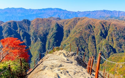
A Paradise of Precious Plants, Mt. Odaigahara, Nara: Video Introduction Photo:Autumn at Mt. Odaigahara, Nara Prefecture This video, titled "[Official] Higashi Odaigahara, Kamikitayama, Nara|Promotional Video (Short Ver.)" (【公式】奈良県上北山村・東大台ヶ原(HIGASHI ODAIGAHARA)プロモーション映像(短編)), was uploaded by "kamikitayama." Mt. Odaigahara is one of the 100 Famous Japanese Mountains and the entire mountain is designated as Yoshino-Kumano National Park. It's divided into Higashi-Odaigahara, which anyone can visit, and Nishi-Odaigahara, which requires advance permission to enter in order to protect the natural environment. Enjoy the beauty of Higashi-Odaigahara, a charming place for hiking, mountain climbing, and even just a walk, in the video below. Higashi-Odaigahara – A Popular Hiking and Trekking Spot With Beginner Courses Photo:A suspension bridge at Mt. Odaigahara, Nara Prefecture Mt. Odaigahara is a sightseeing spot selected as one of the 100 Famous Japanese Mountains and 100 Unexplored Regions of Japan. The mountain is located in Kamikitayama, Nara, in Japan's Kansai region. Mt. Odaigahara is popular among climbers and hikers because of its unrestricted access. Mt. Odaigahara has four trekking trails that can be climbed and hiked, ranging from beginner to advanced courses. The A trail (middle trail) for beginners starts from the Mt. Odaigahara parking lot and passes Hinodegatake, Masakigahara, Owashi Tsuji, Ushiigahara, Ojigura, and Owashi Tsuji before returning to the parking lot again. From the observatory on Mt. Hinodegatake, you can enjoy a panoramic view of the Omine Mountain Range and other mountains, and if the weather is nice early in the morning, you may even be able to see Mt. Fuji. As the name "Hinodegatake" (lit. "Sunrise Mountain") suggests, the summit is known as a sunrise viewing spot where visitors can watch the sunrise from the top of the mountain. Masaki Pass, located just before Masakigahara, offers a mysterious view of dead and fallen trees on a wide hill, and a spectacular view of the Kumano-nada Sea beyond. Masakigahara is a vast grassy area with trees and a view of Masaki Pass in front of it, where wild deer are frequently seen. The highlight of the beginner course in Higashi-Odaigahara is Daijagura, an 800-meter precipice that offers visitors a panoramic view of the Omine Mountains. Trail A for beginners is about 9 km long and takes about 4 hours to complete. Trail B, for intermediate-level climbers, is the same as Trail A with the addition of Shiokara Valley. This popular course has a slope called "Shakunage Slope" (Rhododendron Slope) where rhododendrons bloom for about a week every year from May 20, leading up to Shiokara Valley. Shiokara Valley has a suspension bridge, and visitors can also enjoy a walk along it downstream. Nishi-Odaigahara, a Treasure Trove of Nature That Requires a Permit to Enter Photo:The outdoors of Nishi-Odaigahara Mt. Odaigahara can be divided into two main areas. One is the Higashi-Odaigahara area, where anyone can enjoy climbing and hiking, and the other is the Nishi-Odaigahara area, where advance permission is required to enter the mountain. The Nishi-Odaigahara area is designated as a special protection area to preserve the natural environment, and the number of people entering the mountain is restricted. Nishi Odaigahara receives approximately 5,000 millimeters of annual rainfall, as much as that of Yakushima Island, and features virgin forests nurtured by the rain, allowing visitors to enjoy the landscape with its pristine vegetation. Wildlife and the Four Seasons on Mt. Odaigahara Photo:The Milky Way from Mt. Odaigahara, Nara Prefecture Mt. Odaigahara is home to a large number of wild animals. In addition to the deer of Masakigahara, there are Japanese serows, foxes, tanuki (Japanese raccoon dogs), marten, and Japanese squirrels, as well as many wild birds, such as Eurasian jays and wrens, and great spotted woodpeckers. Mt. Odaigahara is also a popular photo spot because of its lush greenery, seas of clouds, and beautiful starry skies. If you're looking to take some Instagram photos, this is definitely a place to visit! In autumn, you can see the leaves turned beautiful shades of red and orange, and in the cold winter months, if you're lucky, you can see the local flora covered in rime. A Hiking Trip for Advanced Hikers Photo:Dogura Falls, Osugidani Valley, Mie Prefecture For advanced hikers looking for an adventure to discover the beauty that is Japan's nature, there's a course that will take you on a 10-mile hike from Osugidani Valley, an idyllic place of interest, to the breathtaking Mt. Odaigahara. This hike will take even the most advanced hikers at least 2 days to complete due to the terrain, but if you're up to the challenge and have the experience, it's well worth your time. During the hike, you'll pass Dogura Falls (堂倉滝), a waterfall with a 20-meter drop and a beautiful basin where you can relax and take a break while hiking, Nanatsugama Falls (七ツ釜滝), a unique, 7-tiered waterfall, and Shishi-buchi (シシ淵), a breathtaking canyon with a waterfall hidden at the back of sheer cliffs, and a myriad of other points of interest. As the hike will take 2-3 days to complete, you'll need to stay overnight at the rest stop Momonoki Yamanoie (桃の木山の家). The Ohsugidani Tozan Center has maps with detailed courses as well (including this one and other shorter tours), which we highly recommend checking out. ※For information on reservations, routes, and hiking conditions/seasons, please contact the Ohsugidani Tozan Center (大杉谷登山センター). ※Camping and campfires are strictly prohibited in the Mt. Odaigahara and Osugidani Valley area. ※Because weather in the area can change quickly, it's necessary to bring sufficient equipment for rainy conditions. ※If you have any doubts in your hiking abilities or you are unable to acquire the necessary information for a safe hike, we strongly suggest waiting until you are fully prepared. ※It's recommended that you bring a helmet, as there is a danger of falling rocks along the hiking trail. Summary of Mt. Odaigahara, Nara Photo:Osugidani Valley, Mt. Odaigahara, Nara Prefecture Mt. Odaigahara is also a registered UNESCO Eco Park, and efforts are also being made to promote symbiosis between nature and people. When visiting Mt. Odaigahara, it's recommended that you use public transportation. If you take a bus departing from Yamato-Kamiichi Station, you can reach Mt. Odaigahara in about 2 hours. If you're driving, please note that the parking lot may be full during high seasons, such as autumn, when the leaves change color. Mt. Odaigahara, also known as the "Roof of the Kinki Region," is also famous as a summer retreat. A walking map of Higashi-Odaigahara is available for climbers and hikers as well. If you're looking to explore the beautiful outdoors of Japan, then consider a trip to Mt. Odaigahara. 【TripAdvisor】Mt. Odaigahara -
 Video article 3:12
Mt. Daisen and Kitanizawa Stream - Two Places Used to Make Commercials With Famous Artists! Be Amazed by the Natural Scenery of Tottori Prefecture in This 4K Video!
Nature- 393 plays
- YouTube
Mt. Daisen and Kitanizawa Stream in Tottori Prefecture This video, titled "[4K UHD] Summer Mt. Daisen and Kitanizawa stream" ([ 4K UHD ]夏の伯耆大山と木谷沢渓流 Mt.Daisen & Kitanisawa Stream in Summer), was created by AQUA Geo Graphic. It's an introductory video showing Mt. Daisen and Kitanizawa Stream. Mt. Daisen is a mountain at 1,729m (5,700 ft.) above sea level in Tottori prefecture, in Japan's Chugoku region. It is a stratovolcano, but it is not active at present. It is also known as the sacred peak that represents the Chugoku region of Japan. Mt. Daisen is sometimes called Pansan or Hoki Daisen. The name Hoki Daisen derives from the history of western Tottori Prefecture, which was once called Hoki Country. Mt. Daisen is a popular scenic location that has been selected as one of Japan's "Top 100 Mountains" and Japan's "Top 100 Views." The Kitanizawa Stream is a clear stream that originates from Mt. Daisen, and is also designated as a walking route for sightseeing on Mt. Daisen. It is filled with many tourists, especially during the fall foliage season. The video introduces the fresh greenery of Mt. Daisen and the Kitanizawa Stream in beautiful 4K footage. You can enjoy the beautiful natural scenery, the chirping of birds, and the natural sounds of the flowing river, making it seem as if a mountain stream is actually flowing right in front of you. Mt. Daisen and Kitanizawa Stream- Two Beautiful Instagram Locations Photo:Kitanizawa mountain stream When visiting Mt. Daisen, we recommend taking a guided tour with the Oku-Daisen tour guide. It's a popular walking tour where you can enjoy the seasonal natural scenery, such as bird watching in the summer, autumn leaves in the fall, and snowshoeing in the winter. Keep in mind that the tours require a minimum of people before starting. Reservations can be made with the Kofu Tourism Association by phone or email. The first Saturday of the month is Kitanizawa Tour Day, which includes a photo and allows pets and elementary school students to accompany the tour. Feel free to sign up for this walking route, as it's a great way to capture some Instagram-worthy pictures. The crater at the top of Daisen is marked by the rim of a volcano, indicating that it was once a volcano. It's also locally called Hoki Fuji. If you fancy yourself a hike, why not try climbing to the famous Hoki Fuji Rim to see the natural landscape of Mt. Daisen? Speaking of Mt. Daisen, in winter, we recommend the Oku-Daisen Ski Resort. It's the largest ski resort in Tottori Prefecture, with 400 free parking spots. Reservations should be made early, as the resort is quite popular. Oku-Daisen Was Used for Suntory's Natural Water TV Commercials! Photo:Houki Fuji among the stars In 2017, a commercial for Suntory Natural Water, featuring world-renowned female artist Utada Hikaru, was set in Oku-Daisen, a famous mountain that is said to be the highest peak in the Chugoku region. Oku-Daisen is a place where the air and water are so clean that it is said to be a mountain of water, and the atmosphere of its mysterious forest is something straight out of an anime or some other mythological world! The numerous climbing spots capture the hearts of visitors. Okudaisen (奥大山) has a vast beech forest, where you can enjoy a panoramic view of the majestic mountains, and you can see the beautiful starry sky that Utada Hikaru sang about in the TV commercial "#Hoshi Suge" (These stars are beautiful!). The mountain stream that Utada Hikaru visited in the TV commercial is featured throughout this video, where you can enjoy the clear river water of the naturally flowing stream. If you watch the video, you might be able to feel what Utada Hikaru felt, surrounding by the natural beauty of Okudai Mountain. Mountain Climbing and Sightseeing at Mt. Daisen and Kitanizawa Stream Kofu City (江府町, Kofu cho), in Tottori Prefecture, is home to Oku-Daisen, mentioned earlier in the article. The air here is incredibly clear, making it a great place for stargazing, and many campers and photographers come here every year. In the surrounding downtown area and hotels, you can enjoy incredible gourmet cuisine, such as seafood from the Sea of Japan. Summary of Mt. Daisen and Kitanizawa Stream Hoki Daisen Station (JR West) in Yonago is a convenient way to get around, especially for trips to Mt. Daisen, home to the Kinayazawa Stream, one of the clearest rivers in Japan. We recommend using a local bus for transportation from Hoki Daisen Station to hotels, accommodations, and tourist destinations around Mt. Daisen. The highlight of this video is the Kitanizawa Stream, which is shown from 0:36 to the end of the video. The clear water flowing through the lush greenery of a mountain stream in summer, the beautiful moss on the rocks of the stream, and the beautiful sound of the river. It's a truly amazing atmosphere. The video is pleasing to both the eyes and ears. Please enjoy the beauty of Mt. Daisen and the Kitanizawa mountain stream. -
Video article 1:23
The sunflower field in Akeno, Yamanashi Prefecture, has been used as a filming location for a popular movie! The "Hokuto City Akeno Sunflower Festival," an event held when sunflowers are in full bloom, is also a hot topic!
Nature- 346 plays
- YouTube
Drone footage of the Akeno sunflower field in Hokuto City, Yamanashi Prefecture! This video is titled ““Beautiful Drone footage” Akeno Sunflower Field(【絶景ドローン映像】明野ひまわり畑)”. It is a video of the Sunflower Field of Akeno in Hokuto, Yamanashi, in Japan's Kanto region, presented by “Houdoukyoku.” You can see the buds from the beginning of the video and from 0:27, you can see them fully bloomed, in all of their big, beautiful, yellow glory. This popular sightseeing spot “Akeno Sunflower Field” holds Hokuto City Akeno Sunflower Festival every year when the sunflowers are fully bloomed. When is the best time to see the sunflower field in Akeno, where the movie was shot? What are the highlights? Photo:Akeno Sunflower Field in Yamanashi prefecture Hokuto City in Yamanashi Prefecture is said to have the longest hours of sunlight in Japan. The best time to see the sunflowers in Akeno, which grow in full sunlight, is usually from late July to late August. The variety of sunflowers is changed from field to field so that visitors can enjoy them for a long time. Many people visit every year to see the spectacular summer view created by approximately 400,000 sunflowers. The sunflower field became a hot topic because it was filmed for the movie “Be with You” released in 2004. A lot of fans still visit the field to this day. Not only the sunflower fields of Akeno in Yamanashi Prefecture, but in fact there is also a place called Akeno in Ibaraki Prefecture, where an event called the "Akeno Sunflower Festival" will be held. The festival features about 100 double-flowered sunflowers against the backdrop of the famous Mount Tsukuba. When you hear the words "sunflowers in Akeno," that may be what comes to mind for some people. The Sunflower Festival in Ibaraki Prefecture is the Hokuto City Akeno Sunflower Festival! What is the time of year and what are the highlights? Photo:Ice cream The Hokuto Akeno Sunflower Festival 2023 was held from July 22 to August 20, 2023. The event was held at two venues: the main venue and the Rural Park venue. During the event, there were sunflower sundaes, a combination of sunflower soft serve ice cream and shaved ice, crepes, juice, and other café menus, as well as events such as the traditional performing art of sarumawashi. There was also a photo contest, so why not participate by taking a great photo with sunflowers in the background? Although the "Hokuto City Akeno Sunflower Festival 2024" has not been announced as of April 2024, it is expected to be held around the end of July, when sunflowers are at their best. Please check the official website and Instagram for information on sunflowers and the "Hokuto City Akeno Sunflower Festival 2024". Some Info on Sunflowers Photo:Sunflower Sunflowers belong to the daisy family, and its trademark is its bright yellow flower petals. Some of the larger sunflowers grow up to 3 meters tall (~10 ft.). The sunflower seeds can be eaten, and even used for oil. Its scientific name is "helianthus". Heli meaning "sun", and anthus meaning "flower" The sunflower's origin is North America and it is called soleil (which means sun) in some foreign countries . Summary of Sunflower Field in Akeno, Yamanashi Prefecture Source :YouTube screenshot As you can see from the video, Akeno Sunflower Festival in Yamanashi is a very popular sightseeing spot with a very impressive, expansive scenery. A live camera is located around the field as well, so check out the footage collected on sunny days. There are bus tours when the sunflowers are in full bloom so we definitely recommend participating if you have the chance. ◆Akeno Sunflower Field◆ 【Address】5664 Akenocho Asao, Hokuto, Yamanashi 408-0201 【Access】15minutes drive from Chuo Expressway Nirasaki IC or Sutama IC 【Operating Hours】 8:00 to 17:00 【Parking】Parking lot available 【Telephone No】0551-42-1423 【Entrance fee】Free 【Tripadvisor】Akeno Sunflower Field Akeno Sunflower Field -
Video article 4:21
Fuji, which straddles Shizuoka and Yamanashi Prefectures, is the world's largest tourist attraction in Japan. Fuji, which straddles Shizuoka and Yamanashi Prefectures. Its mysterious beauty captivates all who see it.
Nature- 240 plays
- Vimeo
Fuji" across Shizuoka and Yamanashi Prefectures 4K Time-lapse Video Introduction This video is “Mount Fuji | A Time-lapse Film 4K,” made by Daisuke Shimizu. It is a 4K time-lapse of Mt. Fuji. Mt. Fuji is the highest mountain in Japan at 12,000 feet tall, spanning both Shizuoka and Yamanashi Prefectures. Since long ago it has been an object of worship under the name “Reihou Fuji.” In 2013 it was registered as a World Heritage Site, and it has become a famous mountain visited by more than 200,00 tourists, both Japanese and international, every year. Mt. Fuji is still an active volcano, but the last time it erupted was about 300 years ago (1707 AD) during the Edo period. This video introduces the beautiful scenery of Mt. Fuji through a 4K time-lapse. The highlights are the flowing, starry sky, the cityscape spreading into the hills, and the reflection of Mt. Fuji on the surface of a nearby lake. Enjoy the charm of the power spot, Mt. Fuji. Mt. Fuji: A World Heritage Site ©Koichi_Hayakawa Modifying Mt. Fuji is a mountain that spans Shizuoka Prefecture (in Fujinomiya CIty, Susono City, Fuji City, Gotemba City, Koyama-town Sunto-gun) and Yamanashi Prefecuture (in Fujiyoshida City and Narusawa-mura Minamitsuru-gun). It is a world-famous mountain that has been selected as one of Japan's "Three Great Mountains," "Japan's Top 100 Geological Sites," and as a World Heritage Site. In the past, Mt. Fuji was feared for its large eruptions and lava spills, and it was considered a mysterious mountain and an object of worship. It is said that when Mt. Fuji's eruptions subsided, trainees began to step into the mountain to gain the divine and spiritual power of Mt. Fuji. Nowadays, the Fujinomiya peak side of Mt. Fuji is home to Sengen Taisha Okumiya who worships Asama no Ookami (浅間大神), also called Konohanasakuyabime, as the main deity. Also, the summit of the Yoshida and Kawaguchi Lake (河口湖, Kawaguchiko) side is home to Kukushi Shrine. The beautiful figure of Mt. Fuji, said to be the symbol of Japan, has been drawn in various art works, such as the famous “Gaifu Kaisei,” drawn by the Japanese ukiyo-e artist Katsushika Hokusai. Mt. Fuji Is Also Popular Abroad! Photo:Mt. Fuji The mountain climbing season at Mt. Fuji differs by trail. Please note that it is completely closed outside of these climbing seasons. ・ Yoshida trail (Yamanashi Prefecture side): July 1 - September 10 ・ Subashiri trail (Shizuoka Prefecture side): July 10 - September 10 ・ Gotemba trail (Shizuoka Prefecture side): July 10 - September 10 ・ Fujinomiya trail (Shizuoka Prefecture side): July 10 - September 10 ・ Ohachi-meguri Trail (The trail of the crater's rim): July 10 - September 10 The trailhead is near the fifth station, and you can take the Fuji-Subaru Line/Fujiyama Skyline to get to it. You can also get there by car or bus. Parking is also available. The time required for climbing differs by trail, but the Subashiri route takes about 5 hours and 40 minutes and descending takes about 2 hours and 30 minutes. The weather on Mt. Fuji, which is 12,000 ft. above sea level, is extremely variable, and the summit of Mt. Fuji may reach subzero temperatures even during the summer. Headlights are also required if you are climbing in the evening. Mountain climbing on a one-day trip is also possible, but if climb to high in a short time, you run the risk of developing altitude sickness, so please be careful. Fuji also has a number of huts, so we recommend that you take a break at them or stay overnight. Please follow the rules and manners, bring sufficient equipment, and avoid taking any unnecessary risks. The Peak of Mt. Fuji in 4K This article's video introduces the beautiful figure of Mt. Fuji through a 4K time-lapse. From 0:08 in the video, You can see Mt. Fuji in the darkness of the night as the morning sun gradually rises. From 1:15, it is possible to see clouds over the snow capped Mt. Fuji, and from 1:33, there's the highlight of the movie, the mysterious and beautiful starry sky over Mt. Fuji. The video shows Mt. Fuji seen from the beach, an upside-down Mt. Fuji floating on the surface of a lake, a night view at the foot of Mt. Fuji, and many more beautiful sceneries. There might be aspects of Mt. Fuji that you have not seen before! Things to Do Near the Sacred Mt. Fuji Photo:Mt. Fuji and autumn leaves seen from Lake Kawaguchi When you visit Mt. Fuji, be sure to check out the sightseeing spots around Mt. Fuji. This article introduces some recommended sightseeing spots around Mt. Fuji, but there are still more. The World Heritage Center, located in Fujikawaguchiko-machi, Minamitsuru-gun, Yamanashi Prefecture, is a hands-on exhibition and tourism facility where you can enjoy the charms of Mt. Fuji. There's also Fujikyu Highland, a popular amusement park, and many hot springs, hotels, inns, and campgrounds, where you can relax after a long day of travel. Also famous is "Oshino Hakkai," "Shiraito Falls, "Narusawa Ice Cave," and the "Fugaku Wind Cave" where you can feel the clear water of Mt. Fuji. These are also popular as some of Japan's leading power spots. In addition, there are many sightseeing spots around Mt. Fuji, such as "Yamanakako Hananotsu Park," "Mishima Skywalk," "Fuji Safari Park Clematis Hill," and "Children's Country." Gourmet foods that we recommend trying are the local Yoshida Udon and Fujito. The Fuji Sanroku Whiskey, made with delicious subterranean water from Fuji, is also popular. Summary of Popular Sightseeing Spots at Mt. Fuji This time we introduced the charm of Mt. Fuji, a world renown mountain and the symbol of Japan. Be sure to check out the video to see the beautiful 4K footage of Mt. Fuji. It truly is amazing. Mt. Fuji, the tallest mountain in Japan, can be seen from different places all over Japan. Definitely keep your eyes peeled when visiting Japan. 【Official Website】Mt. Fuji Climbing Official Website http://www.fujisan-climb.jp/en/index.html -
Video article 5:38
Taste the great outdoors at Kamikochi in the Japanese Alps, a spectacular sightseeing spot in Matsumoto City, Nagano Prefecture, Shinshu! Surrounded by greenery full of negative ions, spend a healing time.
Nature- 149 plays
- YouTube
Introduction of "Japan Alps Kamikochi" sightseeing video in Matsumoto City, Nagano Prefecture This video, titled "LEAP | Kamikochi (上高地) - Japan - UHD 4K," was released by Jonathan Teo. It shows an aerial view of Kamikochi, a tourist resort area overflowing with natural beauty in Nagano Prefecture. Kamikochi, located in Matsumoto City in western Shinshu, is a scenic, mountainous area situated at an elevation of approximately 1,500 meters above sea level. The entire area makes up Chubu Sangaku National Park (中部山岳国立公園), and is a base for climbing the Hotaka Mountain Range (穂高連峰) and Mt. Yari (槍ヶ岳). If you want to enjoy the beautiful scenery, plan a trip to Kamikochi and explore the mountain route! Recommended Sightseeing Spots in Kamikochi Photo:Kamikochi, Nagano Prefecture After the opening of the mountain, many tourists flock to Kamikochi, which has a series of peaks that are coveted by alpinists, for the purpose of mountain climbing. When climbing in Kamikochi, be sure to get your fill of the unique mountain scenery. Kappa Bridge (河童橋), the symbol of Kamikochi, is a popular spot where you can enjoy a great view. Be sure to also check out Taisho Pond, Myojin Pond, and Tashiro Pond, which are known for their natural beauty. At 0:53 in the video, you can see the Azusa River glowing a cobalt blue. Key Points to Remember When Visiting Kamikochi Photo:Kamikochi, Nagano Prefecture Kamikochi is a fun mountain for both beginners and advanced climbers. If you're looking for a casual hike, consider planning a day trip. The climate in the mountains can change easily, so be sure to suitable clothing when climbing in the Kamikochi area. Also, be sure to bring maps, drinks, and emergency food in your luggage just in case. Inns and Souvenir Shops at Kamikochi in Shinshu, Nagano Photo:A hot spring at an inn There are a number of hot spring inns and tourist hotels in the area around Kamikochi. After a day of hiking, we recommend staying at an accommodation with a hot spring to relax and rejuvenate. There are also many tourist attractions nearby, including restaurants serving local gourmet food and souvenir shops. Summary of Kamikochi, Located in Shinshu, Nagano Photo:The scenery of Kamikochi, Nagano Prefecture There are many scenic spots like the ones shown in this article's video, in Kamikochi. Walking around while enjoying the unique mountain scenery is sure to leave you feeling refreshed. To protect the environment around Kamikochi, personal vehicles are prohibited in and around the area. Park your car at the parking lot in Sawatari before Kamikochi and use the shuttle bus to get there. 【Official Website】Kamikochi Official Website|Area Introduction https://www.kamikochi.or.jp/learn/spots 【Tripadvisor】Kamikochi https://www.tripadvisor.com/Tourism-g12830931-Kamikochi_Matsumoto_Nagano_Prefecture_Koshinetsu_Chubu-Vacations.html -
Video article 8:51
A beautiful video of Oze's skunk cabbages at their best! The video also introduces the best time and places to see skunk cabbages in Oze, famous for the song "Memories of Summer", as well as hiking courses in Oze, which straddles four prefectures, Fukushima, Niigata, Gunma, and Tochigi.
Nature Travel- 314 plays
- YouTube
Video introduction of "Skunk cabbage in Oze" taken in 2022 This video, titled "The Skunk Cabbage of Oze Marsh, 2022|A Skunk Cabbage Colony in the Shimono Ohori River" (2022 尾瀬の水芭蕉 尾瀬ヶ原 下の大堀川ミズバショウ群生地), was uploaded by "Northen Japanese Alps Nature Video." The bright landscape of Oze National Park, introduced in the nine minutes of video, is as beautiful as an impressionist painting. In the video, taken on May 29th, 2022, you can see there is some snow left on the surface of Mt. Shibutsu (至仏山, Shibutsuzan) and the majestic mountain can be seen towering against the blue sky. Fully bloomed skunk cabbages sway in the wind on the vast marshland at the foot of Mt. Shibutsu. The abundance of water in Oze National Park is also home to frogs and other creatures and you can even hear frogs, a sound you won't hear in the cities. Walking along the boardwalk of Oze Marsh (尾瀬ケ原, Ozegahara) while listening to the bubbling of the Shimono Ohori River (下ノ大堀川 Shimono Ohori River) is therapeutic. Oze, a Place Whose Beauty is Sung About in Traditional Japanese Songs Photo:Oze National Park The beauty of Oze is no secret to the people of Japan, and it has even been featured in traditional Japanese songs dating back to the 1940s. But for those of us not familiar with Oze, here's a quick introduction. Oze is a plateau that straddles the four prefectures of Fukushima, Niigata, Gunma, and Tochigi. Oze is a basin surrounded by 2000-meter-tall mountains, such as Mt.Shibutsu (至仏山, Shibtsusan), Hiuchigatake (燧ヶ岳, Hiuchigatake), Mt. Keizuru (景鶴山, Keizuruyama), and Mt. Nakahara (中原山, Nakaharayama). The marshland centering on Oze Marsh, which is said to have been formed around 10,000 years ago, was designated as Oze National Park (尾瀬国立公園 Oze Kokuritsu Koen) in 2007 and as such, the terms "Oze" and "Oze National Park" are synonymous with one another. Oze National Park is a major scenic spot that has been selected as one of the Top 100 Views of Japan. Other than the marshland of Oze Marsh, many ponds and swamps can be seen on the nearby mountainsides. After the snow melts in May, all the plants and trees bloom at once. There are boardwalks and benches as well, so visitors can enjoy a refreshing walk while taking in all of the natural scenery. The Skunk Cabbage of Oze National Park – A Treat for the Eyes Photo:Skunk cabbage Asian Skunk Cabbage is characterized by its large white petals, but these white petal-like things are not actually petals, rather, they are bracts, which are specialized leaves. Skunk Cabbage is called "Mizubasho" in Japanese (水芭蕉, lit. 'Water Banana'). The name comes from the shape of its leaves, which resemble those of the Japanese banana plant, and from the fact that it grows near water. It's a perennial plant of the arum family that grows in mountainous marshlands, and its flowers are at their best from late May to mid-June in Japan. Although bloom dates are dependent on the amount of snowfall each year, the best time to see skunk cabbage in Oze National Park is the same; late May to early June. In the first week of June especially, Oze National Park is crowded with tourists looking to see the clusters of skunk cabbage in bloom. The Nature of Oze National Park & 2 Popular Hiking Courses in the Area There are many hiking courses in Oze National Park, but the two most popular hiking courses are the Ozegahara Course and the Ozenuma Course. These two courses are recommended for first-time visitors to Oze National Park. Incidentally, the hiking course introduced in the video is the Ozegahara Course. Photo:Ozegahara ●Ozegahara Course This course circles Oze Marsh, the largest marshland on Japan's mainland. The boardwalk is well maintained, so even beginners can walk the course with ease. [Main route] Hatomachi Toge (鳩待峠, Hatomachitoge)→ Yamanohana Visitor Center (山ノ花, Yamanohana)→ Kamino - Ohori River (上ノ大堀川, Kamino Ohori Kawa)→ Ushikubi (牛首, Ushikubi)→ Miharashi (見晴, Miharashi)→ Ryugu Hut (龍宮小屋, Ryugu Goya) (Overnight stay). ※If you're visiting on a day trip, turn back at Kamino - Ohori River or Ushikubi. Ryugu Hut→ Miharashi→ Akatashiro Branch (Akadashiro Bunki)→ Yoppi Suspension Bridge (ヨッピ吊橋 Yoppi Tsuribashi)→ Ushikubi→ Yamanohana Visitor Center→ Hatomachi Toge [Video] 1:28 - Walkers on a Well-Maintained Wooden Path Photo:Oze Marsh and Hiuchigatake ●Ozenuma Course This is a hiking course around Lake Ozenuma and it's the course with the least amount of inclines and declines. Although this course can be hiked on a day trip, it's recommended that you stay overnight at a lodge. Lake Ozenuma at sunset with the stars in the night sky makes for an unforgettable experience. The Numayama Pass Observation Deck (沼山峠展望台, Numayama Toge Tenboudai) is located at the end of a conifer forest uphill from the Oze Numayama Pass bus stop. Here you can enjoy a panoramic view of Lake Ozenuma. On the first day, go to Sanpeishita (三平下) via the east bank of Lake Ozenuma. From Sanpeishita, you can see Hiuchigatake (燧ヶ岳, Hiuchigatake) and Lake Ozenuma, making it a popular vantage point. On the second day, start from the south bank of Lake Ozenuma to Numajiri (沼尻, Numajiri). Numajiri is also a beautiful place with ponds and in spring and summer, you can see pygmy water-lilies and Japanese thistle. After passing through the north bank of Oze Marsh, return to Numayama Pass. [Main route] Numayama Pass→ Ozenuma Villa (Overnight stay) Ozenuma Villa→ Numajiri→ Oze Marsh→ Numayama Pass Hotels, Hot Springs, and Where to Eat Near Oze National Park Photo:The Hatomachi Toge Rest Area The Hatomachi Toge Rest Area is located at Hatomachi Toge, the starting point of Ozegahara in Gunma Prefecture. Many tourists use this spot to prepare before hiking and to eat. The Hanamame Soft Cream ice cream is also popular. For visitors to Oze National Park, we recommend the Sky Terrace (天空テラス, Tenku Terasu) located 2,000 meters above sea level and the free Foot Bath in the Sky (天空の足湯, Tenku no Ashiyu). It takes about 15 minutes by the Nikko Shiranesan Ropeway (日光白根山 Nikko-Shirane San) to reach the summit station. Located on the border with Nikko, Tochigi, you can relax while enjoying a view of Mt. Nikko-Shirane. At Oze Katashina, a roadside station in Tone, Gunma Prefecture, visitors can enjoy direct sales of fresh highland vegetables from Katashina Village (片品村, Katashina Mura), as well as delicious meals prepared using locally grown vegetables at Katashina Diner (かたしな食堂, Katashina Shokudo)" and "Village People's Kitchen (村民キッチン, Sonmin Kicchin)." If you are considering staying near Oze National Park, Oze Hut (尾瀬小屋 Oze Koya) is another great spot we recommend. Despite the name of "hut," it's clean and has excellent facilities, such as the Oze Hut Terrace (尾瀬小屋テラス Oze Koya Terasu), which is open to outside visitors, as well as hot springs. The food is so good that it's hard to believe that it's located in the middle of Oze Marsh. How to Get To Oze National Park From Tokyo From Tokyo there are several ways to get to Oze National Park and there are also several different trailheads to enter the park from. From Tokyo, the easiest entry to the park via public transportation is the Hatomachi Toge trailhead. Tokyo Station to Oze National Park: Hatomachi Toge Trailhead From Tokyo Station, take the Joetsu Shinkansen to Jomokogen Station (1 hr. 10 mins), from Jomokogen Station, take a Kan'etsu Bus to Numata Station (25 mins), from Numata Station, take a Kan'etsu Bus to Togura Station (1 hr. 15 mins), and from Togura, once more take a Kan'etsu Bus to Hatomachi Toge (35 mins). In total it will take approximately 4 hours to reach the Hatomachi Toge trailhead from Tokyo Station. Keep in mind that this is just one route and there are many different trailheads with which to start a hike in Oze National Park. Summary of Oze National Park's Charming Skunk Cabbage Oze National Park is the largest high-altitude marshland on Japan's mainland, and straddles the four prefectures of Fukushima, Niigata, Gunma, and Tochigi. Because of its vast geographical area, you can enjoy the nature of Oze with both hiking and overnight stays. When the short summer comes, various flowers bloom in Oze National Park. From late May to June in particular, when skunk cabbages, the representative flower of Oze National Park, are in bloom, many people visit Oze National Park to see the beautiful scenery. We hope this article can help you enjoy your trip to Oze National Park. Be sure to follow the hiking courses introduced above if you visit! 【Trip Advisor】Oze Marsh -
Video article 1:01
An Impressive View of the First Sunrise of the Year at Mt. Fuji – Helicopter Footage From 4,000 Meters + 5 Spots for Watching the First Sunrise of the Year Over Mt. Fuji
Nature Travel- 157 plays
- YouTube
Mt. Fuji – Hatsuhinode: Video Introduction This video, titled "An Aerial View of Mt. Fuji | The First Sunrise of 2022【Shizuoka Shimbun / Your Shizuoka Newspaper】" (富士山上空 2022年初日の出【静岡新聞/あなたの静岡新聞】) was uploaded by "Shizuoka Shimbun【TEAM NEXT】." Jelico No.1, a helicopter owned by Shizuoka Newspaper Inc., filmed Mt. Fuji and the first sunrise of 2022 at approximately 4,000 meters above Fujinomiya, Shizuoka, in Japan's Tokai region. Hatsuhinode is the Japanese tradition of viewing the first sunrise of the New Year. Enjoy the breathtaking sunrise over Mt. Fuji! A Divine View of Mt. Fuji and a Sunrise That Will Take Your Breath Away! Photo:The first sunrise of the year, Mt. Fuji If you're superstitious, then there's nothing more auspicious than Mt. Fuji and hatsuhinode to greet the new year. Moreover, this combination is filmed at the height of 4,000 meters. It's going to take your breath away. [Video] 0:18 - Snow Whirling in the Wind on Mt. Fuji as the Sun Rises In this video, you can also see the rare Kage-Fuji, a phenomenon which can only be seen for a few hours before sunrise and sunset, when only oblique light shines on Mt. Fuji. The shadow of Mt. Fuji can be seen on the surface of the earth or on a sea of clouds. The first sunrise of the year coupled with the Kage-Fuji phenomenon makes for an incredible experience. [Video] 0:30 - The Magnificent Scale of Kage-Fuji Seen From the Sky The photogenic Kage-Fuji in the crisp air is a different experience from what climbers can see, creating a fantastic sight that can only be captured from 4,000 meters in the air. Recommended Spots for Viewing Mt. Fuji and the First Sunrise of the Year Photo:Sunrise and Mt. Fuji from Lake Motosu Mt. Fuji is also called "Reiho" (霊峰), or "sacred mountain" in Japanese, and is loved by the people of Japan. No matter the season, this place is always a popular attraction. Now you're probably thinking "It must be crowded during Hatsuhinode then." Crowding conditions vary from year to year, but here we'll introduce some popular spots and hidden gems where you can view Mt. Fuji. Be sure to take a camera for some awesome photos as well! ●Lake Kawaguchi (河口湖, Kawaguchiko) (Popular) On the side of the lake, there are so many places where you can enjoy views of Mt. Fuji, like Oishi Park (大石公園, Oishi Koen) or Ubuyagasaki (産屋ヶ崎, Ubuyagasaki). The first sunrise of the year rising over the majestic Mt. Fuji illuminates the surface of the lake with a beautiful light. Fuji Sengen Shrine (about 20 minutes away by car) is located nearby and is recommended for hatsumode (the first shrine visit of the New Year). Sunrise: 6:54 a.m., January 1, 2022 ●Lake Motosu (本栖湖, Motosuko) (Popular) The famous Sakasa-Fuji (the upside-down reflection of Mt. Fuji on the surface of a lake) printed on 1,000-yen notes came from the view from this lake. This spot is popular as a top photo spot to witness Diamond Fuji, a beautiful phenomenon where the sunrise hits the peak of Mt. Fuji and shines like a diamond. Unfortunately, whether or not you can see this will depends on the day's weather, so there's no guarantee you'll be able to see it. Sunrise: 6:49 a.m., January 1st, 2022 ●Roadside Station Asagirikogen (道の駅 朝霧高原, Michinoeki Asagirikogen) (Popular) Here, visitors can enjoy restaurants and a variety of local products. Only on January 1st, this area opens at 7:00 AM to warmly welcome people who come there to take photos or enjoy the first sunrise of the year. It's located along Shio no Michi (Salt Road), Route 139, which links Shizuoka with Yamanashi. Sunrise: 6:55 a.m., January 1st, 2022 ●Jukkoku Toge Summit (十国峠山頂, Jukkoku Toge Sancho) (Hidden Gem) The Hakone Jukkoku Toge Cable Car starts running from 5:00 a.m. as a "Hatsuhinode Special Service." On a bright and clear New Year's Day, you can catch Mt. Fuji colored red by the sunrise. Sunrise: 6:52 a.m., January 1st, 2022 ●Senbonhama Beach (千本浜海岸, Senbonhama Kaigan) (Hidden Gem) This beach is approximately 10 km long and is full of pine trees. It's a nice spot where you can avoid the crowds in the area surrounding Mt. Fuji and enjoy the beautiful pine trees with a distant view of Mt. Fuji. Sunrise: 6:52 a.m., January 1st, 2022 Each spot has special New Year's tours. If you're in Japan for the new year, consider staying at a hotel or ryokan and watching the beautiful sunrise over Mt. Fuji. Climbing Mt. Fuji to See the First Sunrise of the Year? Photo:Sunrise, Mt. Fuji There are many people that want to witness the sunrise from the peak of Mt. Fuji. However, the climbing season on Mt. Fuji doesn't start until early July and ends in late September. In general, the climbing season is during the period when the trails are open to the public. Since the opening period differs by trail, please refer to the Official Website for Climbing Mt. Fuji. New Year's means winter on Mt. Fuji, and weather conditions can be harsh, leading to an increased risk of accidents. Therefore, if you're planning on climbing Mt. Fuji, be sure to keep this in mind and be extra careful. Summary of the First Sunrise of the Year at Mt. Fuji This article introduced information about the first sunrise of the year at Mt. Fuji, a sight that many people wish to see. There are tons of good places to watch the sunrise, including popular spots and hidden gems. There are also risks to be aware of if you're planning on climbing Mt. Fuji to watch the first sunrise of the year. Having a good New Year's Day is the key to having a good year. Watching the sunrise at Mt. Fuji is one of the best ways to start your year off right. Be sure to dress warm and enjoy the amazing view! 【TripAdvisor】Mt. Fuji -
Video article 3:15
Kyuanji Temple – A Flower Temple in Osaka, Japan Famous for Its Hydrangeas. Learn the Best Time to Visit and What to See When Visiting
Nature Festivals & Events Travel- 251 plays
- YouTube
The Hydrangeas of Kyuanji Temple, Ikeda, Osaka: Video Introduction This video, titled "Osaka Walk - Kyuanji Temple Hydrangea in the pond 4K HDR Japan," was uploaded by "Osaka BlackCat." In Japan, hydrangeas blooms in June, the rainy season. This video shows the beautiful floating hydrangeas at Kyuanji Temple—a temple on the Kansai Flower Temple pilgrimage—which can be seen each year in June. Please enjoy the photogenic sight of the colorful hydrangeas floating on the surface of the water, as well as the solemn beauty of the temple's rich natural setting. An Introduction to Kyuanji Temple, a Kansai Flower Temple Photo:Kyuanji Temple, Ikeda, Osaka Kansai Flower Temples refers to a group of 25 temples in Japan's Kansai region that are famous for their flowers. Kyuanji Temple in Ikeda, Osaka, is the 12th temple on the list of Kansai Flower Temples and is a member of the Koyasan Shingon sect of Buddhism. Surrounded by nature, the temple grounds cover an area of 20,000 tsubo (16 acres), where beautiful scenery, such as hydrangeas, cherry blossoms, autumn leaves, azaleas, and peonies can be seen throughout the year. Kyuanji Temple has a history of more than 1,200 years. In the Azuchi-Momoyama period (1573-1598 A.D.), the temple was visited by the famous Japanese warlord and well-known hobbyist Toyotomi Hideyoshi, and has been loved by many visitors as a historic temple used for tsukimi (moon viewing) and tea ceremony. Shuin stamp collectors can pick up a special kirie shuin, available only during the rainy season. It features a hydrangea and the main deity of the temple, Kannon (the Goddess of Mercy). The artistic kirie shuin stamp is truly one-of-a-kind. In the fall, a shuin stamp with a design of autumn leaves is also available for a limited time, making it a must-visit spot for collectors. See the Photogenic Floating Hydrangeas in June! Photo:Hydrangeas at Kyuanji Temple, Ikeda, Osaka Kyuanji Temple has approximately 1,000 hydrangea plants of six different varieties planted on its grounds. The sight of the colorful purple, yellow, red, and blue hydrangeas floating on Gusokuike Pond is especially photogenic. The hydrangeas glistening in the sunlight are so beautiful that it's like paradise. [Video] 0:00 - Floating Hydrangeas The hydrangeas at Kyuanji Temple begin blooming in early June each year, and the Ajisai Ukabe "Floating Hyndragea" event is held in mid-June, when the early blooming hydrangeas can be seen floating on the pond. The hydrangeas at Kyuanji Temple can be enjoyed from mid-June to early July, an in 2022, they were at their best in late June. The blooming status is announced on the Kyuanji Temple Instagram (@kyuanji) from time to time. Be sure to check it out before visiting. Other Attractions at Kyuanji Temple Photo:Autumn leaves at Kyuanji Temple, Ikeda, Osaka Kyuanji Temple is decorated with a variety of flowers throughout the year, but its highlights are not limited to hydrangea and autumn leaves. The large tower gate is designated as a National Important Cultural Property. The roof of the gate has a unique appearance and is said to resemble a bird spreading its wings in preparation for flight. The Hall of the Reclining Buddha, a pagoda where the image of the reclining Buddha is enshrined, is decorated with relief sculptures of Buddha on the walls, creating a mysterious atmosphere. In the garden Koku-en, visitors can enjoy weeping cherry blossoms and other seasonal flowers. The entrance fee to Kyuanji Temple is 300 yen. [Video] 1:09 - Koku-en Garden How to Get to Kyuanji Temple in Ikeda, Osaka Since Kyuanji Temple is surrounded by nature, it is often thought to be in an inconvenient location in the mountains, but it's surprisingly accessible! From Ikeda Station, on the Hankyu Raolway, it's a 15-minute ride to the temple via Hankyu bus. If you're driving, the temple is located approximately 5 km (~15 mins) from Hankyu Ikeda Station. The temple has a free parking lot, but please note that during the hydrangea season, the free parking lot can fill up quickly. Things to Do Near Kyuanji Temple Kyuanji Temple is another temple located in a somewhat remote location. Because of this, you'll need to make your way back into the nearby city of Ikeda to find other things to do, but there's no shortage once you arrive. Here are a couple things to do nearby. Satsukiyama Zoo Satsukiyama Zoo is located approximately 20 minutes from Kyuanji Temple. The zoo is home to a variety of different animals, such as rabbits, wallabies, ponies, etc., and is a nice spot to see the cherry blossoms in Osaka in the spring. The zoo is also completely free to enter. Hours: 9:15 am - 4:45 pm. Shop hours are 10:00 am - 4:00 pm (Mon. - Fri.) and 10:00 am - 5:00 pm (Sat. & Sun.) Closed: Tuesdays Admission Fee: Free CUPNOODLES MUSEUM Located 25 minutes from Kyuanji Temple and 20 minutes by train or on foot from Satsukiyama Park, the CUPNOODLES MUSEUM shares the story of cup noodles and how they came to be, as well as the life of Momofuku Ando, the inventor of cup noodles. There are also workshops inside the museum where you can make chicken ramen or make your own unique cup noodles package. Admission to the museum is free. Hours: 9:30 am - 4:30 pm (Last entry 3:30 pm) Closed: Tuesdays and Year-end/New Years Holidays. ※If Tuesday is a National Holiday, the museum will be closed the following day. Admission Fee: Free There are many more things to do in the area, so we recommend doing your research before visiting so you can build the perfect itinerary! Summary of Hydrangeas at Kyuanji Temple Photo:Hydrangeas at Kyuanji Temple, Ikeda, Osaka We hope you enjoyed this introduction to the hydrangeas at Kyuanji Temple. In the video, it was a beautiful sunny day with the sun shining through the trees, but hydrangeas bloom during the rainy season. If you plan on visiting Kyuanji Temple to see them, don't forget to bring rain gear. Summer is just around the corner once the rainy season ends, so consider visiting Kyuanji Temple in June. You can take some wonderful photos during your visit and share the traditional Japanese aesthetics on Instagram! 【TripAdvisor】Kyuanji Temple -
Text only
Mt. Fuji in COOL JAPAN VIDEOS Photo Contests: 10 Photos Showcasing the Different Views of Mt. Fuji
Nature Travel- 1.25K views
COOL JAPAN VIDEOS is always holding photo contests. This time, we have selected photos that capture the majestic Mt. Fuji, located on the border of Yamanashi and Shizuoka prefectures. We'll also introduce the locations where the photos were taken, so be sure to enjoy each one so you don't miss out on some useful information! COOL JAPAN VIDEOS is a social, video curation site that introduces the charms of Japan to people around the world who are interested in Japan. Our photo contests allow you to participate and even win with photos taken via your smartphone! Stick around to learn more! ■Table of Contents - Mt. Fuji in Past Photo Contests The Aftermath of the Hoei Eruption Swans at Lake Yamanaka The Tea Fields of Obuchi Sasaba Fujiyoshida Oshino Hakkai Aka-Fuji The Daikanzan Observatory Kawaguchi Asama Shrine The Fumotoppara Campground The Takabocchi Highlands - Features of COOL JAPAN VIDEOS Photo Contests - Current Photo Contest - Summary of Mt. Fuji in COOL JAPAN VIDEOS Photo Contests Mt. Fuji in Past Photo Contests Let's take a look at some of the wonderful photos taken of Mt. Fuji from the many fantastic works that convey the beauty of Japan. COOLJAPANVIDEOS Photographer: 01ktk15 Location: Mizugatsuka Park (Susono, Shizuoka) A Place Where You Can Photograph the Aftermath of the Hoei Eruption Fuji's flanks were blown away by the Hoei Eruption in 1707 during the Edo period (1603-1868 AD), forming the bowl-shaped Hoei Crater. At Mizugatsuka Park, you can photograph the crater in its entirety as it changes from season to season. The crater is located along the Fuji Skyline, near the second station of Mt. Fuji at an elevation of 1,450 meters. You can capture powerful compositions that include the beauty of Mt. Fuji, while reminding you that it's still a mighty volcano. An Article About Mt. Fuji Video article 4:21 Fuji - Japan's Largest Tourist Attraction and the Pride of the Country. Its Mysterious Beauty Fascinates All Who See It YouTube COOLJAPANVIDEOS Photographer: タケタロ Location: Lake Yamanaka (Minamitsuru, Yamanashi) When to See Swans at Lake Yamanaka Swans can usually be seen at Lake Yamanaka around December and fly back north around March or April. Some species of swans are don't migrate, and instead lay eggs and raise their young in the grassy knolls along the shores of Lake Yamanaka in spring. Mt. Fuji is located to the southwest of Lake Yamanaka. If you're looking to capture the majestic Mt. Fuji with beautiful swans and snowy winter scenery in one photograph, the northern shore of Lake Yamanaka is your best bet. A Sightseeing Article About Lake Yamanaka Video article 1:53 Go Sightseeing at Lake Yamanaka, Nestled at the Foot of the Sacred Mt. Fuji! The Yamanakako Area, Surrounded by Nature, Is One of the Top Sightseeing Destinations in Japan! YouTube COOLJAPANVIDEOS Photographer: phantastic420 Location: Obuchi Sasaba (Fuji, Shizuoka) The Tea Fields of Obuchi Sasaba Obuchi Sasaba in the Obuchi district of Fuji City is a photo spot where you can capture Mt. Fuji over vast tea fields with no power lines or buildings to obstruct your view. Many photographers come to capture the verdant tea fields with the towering Mt. Fuji in the backdrop. Located about 10 minutes by car from the Tomei-Fuji and Shin-Tomei Shin-Fuji interchanges, the best time to visit is when the tea leaves are sprouting, particularly from mid-April to mid-May. An Article About Tea Fields and Mt. Fuji Video article 2:09 Obuchi Sasaba - Beautiful Tea Fields and Mt. Fuji in Shizuoka, Japan! YouTube COOLJAPANVIDEOS Photographer: Yuto Yamada Location: Fujiyoshida, Yamanashi Fujiyoshida, a Town With an Amazing View of Mt. Fuji Fujiyoshida, in Yamanashi prefecture, is the closest town to Mt. Fuji and features spectacular views of the mountain. In particular, at Arakurayama Sengen Park, it's possible to capture Mt. Fuji, cherry blossoms, and the 5-story Chureito Pagoda in one frame. Fuji, cherry blossoms, and the five-story pagoda in the frame. On top of the cherry blossoms in spring, visitors can enjoy the depth and splendor of each season here, including the fresh greenery of summer, the autumn foliage in fall, and the splendid snow landscapes in winter, all of which are sure to delight. An Article on Kitaguchi Hongu Fuji Sengen Shrine in Fujiyoshida Video article 3:16 Kitaguchi Hongu Fuji Sengen Shrine - Learn About One of Japan's Most Famous Power Spots, Located in Yamanashi Prefecture, Where the Sacred Mt. Fuji Resides, and Information About Popular Amulets and Shuin Stamps for Tourists! YouTube COOLJAPANVIDEOS Photographer: Nguyen Vu Location: Oshino Hakkai (Minamitsuru, Yamanashi) The Beautiful Oshino Hakkai Oshino Hakkai is a sacred spring located at the foot of the natural monument, Mt. Fuji, and is considered a power spot. The pure spring water from Mt. Fuji, a sacred mountain, is said to hold sacred power. This photo conveys the atmosphere and purity of Oshino Hakkai. If you visit Oshino Hakkai, be sure to take a picture, as it will be treasured for a lifetime. An Article on Oshino Hakkai Video article 4:22 Oshino Hakkai - Breathtaking Scenery at the Foot of Mt. Fuji! YouTube COOLJAPANVIDEOS Photographer: Phúc Jindo Location: Oshino, Yamanashi Photographing the Auspicious Aka-Fuji Aka-Fuji (Red Fuji) has long been a symbol of good luck for warding off evil spirits and bringing prosperity to business. It is a sight that photographers all over Japan hope to see. However, the conditions for photographing Aka-Fuji are very specific. Aka-Fuji can only be seen from the eastern side of the mountain from late summer to early autumn, just after sunrise, and on a clear day after rain. If you're a photographer and up for a challenge, we definitely recommend trying to capture this beautiful sight. An Article About Narusawa, Yamanashi, Located at the Foot of Mt. Fuji Video article 2:40 Introducing “Narusawa, Yamanashi,” Home to the Tallest Mountain in Japan. Behold the Jaw Droppingly Beautiful Scenery of Mt. Fuji. YouTube COOLJAPANVIDEOS Photographer: 01ktk15 Location: Daikanzan Observatory (Ashigarashita, Kanagawa) A Breathtaking View From the Daikanzan Observatory The name "Daikanzan" (lit. "Large Viewing Mountain") comes from the artist Yokoyama Taikan, who liked to paint Mt. Fuji from the Sky Lounge at the summit of the 1,011-meter-tall mountain. The spectacular view makes for an excellent photo and will take up a special place in your heart. It's especially popular in winter when the air is crisp and clear. Mt. Fuji and Lake Ashinoko covered with snow is guaranteed to result in a dignified work of art. An Article on the Best Places to View Mt. Fuji Video article 7:32 The Graceful Sight of the World-Famous Mount Fuji Can Be Enjoyed From All Over Japan. This Article Will Help You Find a Spot to View Mt. Fuji That’s Just Right for You! YouTube COOLJAPANVIDEOS Photographer: Phúc Jindo Location: Kawaguchi Asama Shrine (Minamitsuru, Yamanashi) Kawaguchi Asama Shrine – A Torii in the Sky Kawaguchi Asama Shrine was built to worship Mt. Fuji's god, Sengen-O-no-kami, in order to quell a major volcanic eruption of Mt. Fuji. The torii gate is located approximately 30 minutes on foot from the shrine grounds, and the view of Mt. Fuji is beautiful beyond words. It's also called the "Torii in the Sky," and is a recommended spot known for being especially picturesque. An Article on Kawaguchi Chigo no Mai at Kawaguchi Asama Shrine Video article 3:15 Kawaguchi Sengen Shrine, Now a World Cultural Heritage Site! A Look at the Beautiful Traditional Dance, "Kawaguchi Chigo no Mai"! YouTube COOLJAPANVIDEOS Photographer: mioka Location: Fumotoppara Campground (Fujinomiya, Shizuoka) Mt Fuji From the Fumotoppara Campground The best part about the Fumotoppara Campground is that you can see Mt. Fuji in its entirety from the summit to the base. It is truly a picturesque view. Located in Fujinomiya, the Asagiri Plateau, known for its foggy appearance, is also in the vicinity. At the Fumotoppara Campground, a place loved by campers, you can experience the outdoors with a magnificent view of Mt. Fuji. An Article on the Yamanakako Fuji Snow Festival Video article 3:10 Enjoy the Beauty of Mt. Fuji to the Fullest at the Yamanakako Fuji Snow Festival! YouTube COOLJAPANVIDEOS Photographer: HKP Location: Takabocchi Highlands (Shiojiri, Nagano) Mt. Fuji From the Takabocchi Highlands From the summit of the mountain, which offers a 360-degree view of the Takabocchi Highlands, Lake Suwa, the lights of the city by the lake, and the sea of clouds all add to the main attraction of Mt. Fuji. The area is especially spectacular from autumn, when the air is clear and the night views are spectacular, to the time when the access road is closed for the winter. It's hard to take a better picture than Mt. Fuji and a sea of clouds, early in the morning, before the sun rises and when the sky is tinted orange. An Article on the Mt. Fuji World Heritage Centre Video article 2:32 The Mt. Fuji World Heritage Centre Is a New-Age Museum That Fuses Digital and Analog! The Museum, Located in Fujikawaguchiko, Yamanashi, Is Full of Facilities That Convey the Beauty of the World Heritage Site Mt. Fuji! YouTube Features of COOL JAPAN VIDEOS Photo Contests COOL JAPAN VIDEOS is a social, video curation site that showcases the charms of Japan to people around the world who are interested in Japan. Click here for more information about COOLJAPANVIDEOS Anyone can enter COOL JAPAN VIDEOS' photo contests! Below are some of the features of our contests. ・On top of single-lens reflex cameras and digital cameras, photos taken with smartphones and other devices can also be submitted. ・Each person can submit as many photos as they like during the contest period. ・Editing of images, such as cropping and color changes, is also allowed! Here you can find all of the past photo contest winners in one place. You can also see the prizes for each contest, as well as the locations where the photos were taken and the judges' critiques. Click here to see past photo contest winners Text only Photo Contest Results - COOL JAPAN VIDEOS Winning Photos - Discover the Charms of Japan! Current Photo Contest The following is information about the current photo contest. [Ongoing From November 2023] The 20th COOL JAPAN VIDEOS Photo Contest Theme: The Beauty of Japan Submission period: November 1, 2023 0:00 AM – December 31 2023 11:59 PM(JST) Prizes: ■Grand Prize: 30,000 yen Amazon gift card (1 Winner) ■Honorable Mentions: 10,000 yen Amazon gift card (5 Winners) The Beauty of Japan Photo Contest Landscape Photography Summary Did you enjoy these landscape photos from past photo contest entries? Some of these landscapes can only be seen in specific conditions. Japan is full of rich nature, historical locations, and seasonal events! Share your photos with the world and help showcase the beauty of Japan through COOL JAPAN VIDEOS! Related Articles Text only Children of COOL JAPAN VIDEOS Photo Contests: 10 Heartwarming Photos That Will Put a Smile on Your Face! Text only Autumn in COOL JAPAN VIDEOS Photo Contests: 10 Beautiful Photos of Autumn in Japan Text only Mt. Fuji in COOL JAPAN VIDEOS Photo Contests: 10 Photos Showcasing the Different Views of Mt. Fuji Text only Hokkaido in COOL JAPAN VIDEOS Photo Contests: From Popular Sightseeing Spots to Exotic Animals, Discover the Beauty of Japan's Northernmost Prefecture! Text only Tohoku in COOL JAPAN VIDEOS Photo Contests: Hot Springs, Festivals, Snowscapes, and More – 10 Beautiful Photos of Japan's Tohoku Region! Text only Kyoto in COOL JAPAN VIDEOS Photo Contests: 10 Beautiful Photos of Kyoto, the Ancient Capital of Japan, and Its Most Popular Tourist Attractions! Text only Tokyo in COOL JAPAN VIDEOS Photo Contests: 10 Photos Featuring the Charms of Tokyo, the Capital of Japan + Popular Tourist Attractions! Text only Winter in COOL JAPAN VIDEOS Photo Contests: 10 Photos Capturing the Beauty of Winter in Japan. Snowy Landscapes, Glittering Illuminations + More! Text only Kansai in COOL JAPAN VIDEOS Photo Contests: 10 Spectacular Views of Japan's Kansai Region. From Night Views to Traditional Events, Discover the Best Photo Spots in Kansai! Text only Cherry Blossoms in COOL JAPAN VIDEOS Photo Contests: 10 Amazing Views of Cherry Blossoms, from Castles and Temples to Rows of Cherry Blossom! .separation_line { border-width: 0 0 8px; border-style: solid; border-image: url('data:image/svg+xml,') 0 0 100% repeat; width: 216px; margin:auto; margin-bottom: 50px; } -
Video article 4:17
The Transparent Waters of Sunayama Beach on Miyakojima + Sightseeing Spots and Attractions on the Island in Okinawa
Nature Travel- 166 plays
- YouTube
Aerial Footage of Sunayama Beach on Miyakojima: Video Introduction This video, titled "[Drone Aerial Photography] Sunayama Beach, Miyakojima|Healing Drone Okinawa" (【ドローン空撮】宮古島 砂山ビーチ Healing Drone Okinawa), was uploaded by "Umi Note." It introduces the beautiful blue skies, sandy white beach, and clear waters of Miyakojima. Highlights of Sunayama Beach – Spectacular Views at Every Turn! Photo:Sunayama Beach, Miyakojima, Okinawa Sunayama Beach is located approximately 4 km from the center of Hirara, a city in Miyakojima, Okinawa Prefecture, in Japan's Kyushu Region. Despite its easy accessibility, the beach is surrounded by unexplored nature and beautiful, clear waters. The video shows the spectacular views of Sunayama Beach from beginning to end. The drone offers a unique view that you wouldn't normally be able to see, and the beach seen from the ocean side is so beautiful that it will leave you speechless. [Video] 0:35 - View From the Beach As the name of the beach suggests (砂山, Sunayama; lit. "Sand Mountain"), it's located over a small sand hill. From the parking lot near Sunayama Beach, there is a narrow path leading uphill. It's a bit difficult to climb while carrying luggage, but the view after reaching the top makes it totally worth the effort. You can't help but stop to take in the view. The Rock Arch at Sunayama Beach – A Popular Instagram Spot! The rock arch is a popular spot at Sunayama Beach. You can see the blue ocean through the rock and take photogenic pictures as well. It's also known as a sunset spot, where you can even see the sunset over the ocean inside the rock arch. We recommend relaxing on the beach and watching the sun set inside the rock arch. Things to Be Careful of at Sunayama Beach Photo:Sunayama Beach, Miyakojima, Okinawa The fact that Sunayama Beach is mostly unspoiled by human hands, means that it's full of natural beauty, but this also means there are a few precautions you should take when visiting the beach. The rock arch is currently closed off due to the danger of falling rocks and collapse. Visitors are advised to only go close to the rocks to take pictures. You can also swim at Sunayama Beach, but the waves are surprisingly tall and accidents have been known to occur. Be careful when snorkeling in areas where the water is even a little deep. Swim rings and life jackets may be necessary. There are also signs warning of sharks. We recommend staying in the shallow areas at Sunayama Beach, as there are no lifeguards on duty. Stay away from the beach when there is a surf advisory in effect. It's important to remember that you're dealing with nature, so please keep this in mind while enjoying your time on the beach. Restrooms and shower rooms are located in the parking lot. Toilets should be used before heading to the beach. The path to the beach is hilly and a bit long, so flip-flops or comfortable walking shoes are recommended. If you're with children, be sure to hold their hands when walking. There are no beach houses or restaurants on Sunayama Beach, so be sure to bring your own food or have lunch in the area. We recommend Sunayama Cafe in front of the beach. How to Get to Sunayama Beach Photo:An aerial view of Sunayama Beach, Miyakojima, Okinawa Compared to the main island of Okinawa, Miyakojima is relatively small. By car, it takes only 20 minutes to reach the beach from Miyako Airport and 10 minutes to reach from Hirara Port. Free parking is available as well. The video shows an aerial view of the entirety Miyakojima. [Video] 3:20 - Miyakojima From the Sky If you don't have a car, you can also rent a bicycle. If you rent a bicycle at Hotel Atoll Emerald Miyakojima, you can get to Sunayama Beach in about 15 minutes. Miyakojima Sightseeing Spots! In addition to Sunayama Beach, there are many other places on Miyakojima where you can enjoy the beautiful ocean, such as Yonaha Maehama Beach, Aragusuku Beach, and Shigira Beach. In addition to taking a dip in the ocean, simply admiring the scenery will leave you feeling content. Also, with the opening of the Miyako Shimojishima Airport Terminal in 2019, there are more fashionable cafes and restaurants. Miyakojima Tokyu Hotel & Resorts and Shigira Bayside Suite Alamanda are the most famous resort hotels, but there are also many nice hotels scattered throughout the area. Summary of Sunayama Beach, Miyakojima If you haven't already watched the video, be sure to check it out! You can enjoy Miyakojima's Sunayama Beach from the sky. Enjoy the sandy white beach, blue sky, and the crystal-clear waters of Miyakojima. If you're planning a trip to Okinawa, why not extend your trip a little further and visit Miyakojima? There are connecting flights to Miyakojima from Naha Airport and direct flights from Tokyo, Osaka, and Nagoya. The beautiful Sunayama Beach is waiting for you just beyond a sandy mountain. This is a place you don't want to miss! 【TripAdvisor】Sunayama Beach, Miyakojima https://www.tripadvisor.com/Attraction_Review-g680765-d1382554-Reviews-Sunayama_Beach-Miyakojima_Okinawa_Prefecture.html -
Video article 3:07
This clarity and beauty is CG! At Monet's Pond, a very popular tourist spot in Seki City, Gifu Prefecture, a beautiful, colorful scene like a painting spread out before my eyes!
Nature Living Things Travel- 9.15K plays
- YouTube
Video Introduction of "Monet's Pond," a popular tourist attraction in Seki City, Gifu Prefecture This video is titled "[4K Ultra HD] Monet's Pond - The pond, such as Monet paintings (Shot on RED EPIC)([ 4K Ultra HD ] モネの池 The pond,such as Monet paintings (Shot on RED EPIC))". Many of you may be surprised by the beauty of it. This video introduces Monet's pond, a popular tourist destination in Seki (関市, Seki shi), Gifu Prefecture, in Japan's Tokai Region. The beautiful spring in Gifu Prefecture is said to be visited by many tourists from both Tokyo and Osaka. It can be enjoyed in the video and images in this article. A variety of colorful water lilies can be seen in the spring, including yellow water lilies and more in just a 3-minute video. What Is Monet's Pond? Photo:Gold carp Monet's pond is an officially unnamed pond about the size of a tennis court, formed from the spring water around Nemichi Shrine (根道神社, Nemichi jinja) in the mountains. It was popularized through TV programs and word of mouth as the real life version of "Water Lilies" by the famous French painter Claude Monet. The beautiful Monet's Pond, has colored carp (錦鯉, Nishikigoi) swimming through its transparent waters and is great for taking Instagram photos. There are koi whose head patterns look like heart symbols in the pond, as well as gold carp for good luck. The History of Monet's Pond In 1999, the nearby flower seedling producers weeded and some carp were brought in by locals. It's purpose was not sightseeing, so it was mere chance that such natural beauty came to be. Golden Week in 2016 even attracted 3,000 tourists per day! Highlights and Recommended Seasons for Visiting Monet's Pond Photo:Monet's Pond The best time to visit Monet's Pond to experience its full beauty is during the fall when you can enjoy the magnificent view of the autumn leaves reflecting off the pond's surface. This can be seen from 1:10 in the video. We also recommend going in early May when the spring greenery is fresh or in the winter to see the beautiful snowscape. As the appearance will change considerably depending on the weather, we recommend avoiding rainy days and going at night. Access to Monet's pond is about 35 minutes from the Mino IC on the Tokai Hokuriku Expressway. You can also go to Gifu Prefecture through a sightseeing bus tour around Monet's pond and other surrounding areas. Sightseeing at Monet's Pond Photo:Grilled sweetfish Around Monet's Pond you'll find shops selling the famous "chimaki" (a dumpling wrapped in bamboo leaf), so be sure to give it a try if you get the chance! We also recommend trying the specialty eel or sweetfish (ayu cuisine) lunch in Seki. When visiting Monet's pond, you can visit the Gifu Prefecture Hundred Year Park, Kasuga Shrine, Asakurayama Promenade, Kifune Shrine, Kaore Valley, Takaga Valley, Seki Blacksmithing Tradition Museum, Koka Shrine, Horado Enku Memorial Hall, Roadside Station "Rusten Hola Do," and more. The Itadori Hydrangea Festival is held in early summer in Seki, so be sure to visit Flower Park Itatori when the hydrangeas are at their best. Summary of Monet's Pond This time, we introduced a 4K video of Monet's Pond, a pond as beautiful as beautiful as an impressionist painting. Monet's Pond is perfect for those who want to enjoy the charming scenic beauty of nature, as well as photography lovers. Book a hotel in Seki and set out on a sightseeing trip to enjoy the amazing views in the area. If you like the artistic scenery of Monet's Pond, we recommend visiting Monet's Garden in Kitagawa, Kochi Prefecture. The landscape of Monet's Pond changes depending on the weather. We recommend that you check the weather forecast on the day you plan your sightseeing trip so that you aren't disappointed because you weren't able to see it at its most beautiful. ◆Monet's Pond◆ 【Address】〒501-2901 1643-17 Itadori Kamigase, Seki City, Gifu Prefecture 【Access】About 35 minutes from Tokai Hokuriku Expressway Mino IC 【Closures】None 【Average time spent here】1-2 hours 【Parking】Available. Up to 200 standard vehicles 【Telephone No】0581-57-2111 【Admission fee】None 【Notes】Feeding the fish is prohibited The transparency of the pond changes depending on the weather. 【Tripadvisor】Monet's Pond https://www.tripadvisor.com/Attraction_Review-g1019693-d12479612-Reviews-Monet_s_Pond-Seki_Gifu_Prefecture_Tokai_Chubu.html -
Video article 4:00
Superb 4K video of beautiful rice fields in Aizuwakamastu City, Fukushima Prefecture! The scenery of golden rice ears dyed by the setting sun is soothing.
Nature- 366 plays
- YouTube
Video introduction of rural landscape of Aizuwakamastu City, Fukushima Prefecture To us Japanese, our staple food is rice. And where there is rice, there are rice paddies! You'll be completely absorbed by the view of the rice paddies during the autumn season that the 4K video “Japan Rice Paddies in autumn afternoon-views of rice paddies before the autumn sunset 4K (Ultra HD)(Japan Rice Paddies in autumn afternoon - 田んぼの風景・秋の夕暮れ前 4K (Ultra HD))” has to offer. The place where they shot the footage is the paddy field area in Aizuwakamastu of the Fukushima prefecture, in the rice-producing district of Japan's Tohoku region. From the beginning of the video, you can see the Japanese pampas grass around the rice paddy, and from 1:19, the ears of rice slowly being colored into a golden hue can be seen as well. The singing of the insects combined with the melody of the nearby river also relaxes the mind and makes you feel at peace. These kind of rural landscapes aren't uncommon in Japan either. The most Instagrammable, breathtaking sights to behold are the “Senmaida” and the “Tanada”, which are rice paddies or rice terraces that are cut into the steep mountain slope in a stair-like shape. This miraculous scenery is the crystallization of the wisdom of our ancestors. How Much Do You Know About Japan’s Paddy Fields? Photo:Rural landscape The scenery of Japan’s rice paddies is said to be the absolute perfection of inner peace and relaxation. However, how much do you know about Japan's rice paddies? The scientific name for Japanese rice is "Japonica rice" and as you've probably guessed, it originates from Japan. In the history of paddy field cultivation, Indica rice was cultivated in Southeast Asia. However, this rice is different from Japonica rice. The rice eaten in the present day, which has a special characteristic that makes it suitable for the Japanese climate, has a long history of agriculture in Japan. Photo:Rural landscape So, we will now introduce some basic knowledge about the rice paddies of Japan. First of all, the map symbol of a rice paddy is 2 lines. This symbolizes the “Aze” (the furrow between the paddy fields). The rice paddy is thought to be part of an idyllic scenery of nature. However, it is a man-made agricultural land formation, and the furrows are man-made paths between each rice paddy so people can work on the fields. Between the furrow and the rice paddy, there are waterways that help manage water. Paddy fields are measured in units called “Tan” and 1 Tan is about 991.74 square meters big. Rice Paddies and the Divine Photo: White rice Shinto is an original religion of Japan and deifies nature. The highest object of worship is the Emperor. Every year in November, there is The Niiname Festival(新嘗祭,Niiname-sai), held in the Imperial palace, in which the emperor prays for a bountiful harvest in the coming year. During this time, grains that are harvested from a lucky direction as designated through divination, will be eaten by both the Emperor and Empress. As you can see, for Japan, planting rice is not just an act of agriculture; it has significant cultural relevance as well, and rice was also used to pay annual tribute (presently known as taxes) in the past. Therefore, rice paddies were an important infrastructure that have supported the very heart of Japan since ancient times. How to Make Paddy Fields Photo:Rice planting Rice cultivation is in autumn. Depending on the region, however, usually the preparation of rice beds and seedlings start around March. There are many things that need to be done to prepare for rice planting as well: repairs on furrows, spreading of fertilizer, plowing and irrigating the fields ( to prevent damage from weeds or water leakage), filling the paddies with water, and then finally planting the rice seedlings. Come summertime, weed killers and pesticides are used to manage the growth of the rice, and in autumn the rice is harvested, some made into seedlings again, and the rest is threshed and put on a rice rack to dry. Referred to as "tilling", this act involves creating hills and soil beds in the rice field, as well as creating ice-field furrows and dams. In the modern day, much of the work is mechanized, however, in the past this was all done by hand. Summary of Japan’s rice paddies Photo:Rice paddy in Summer A rice paddy and a regular farm field are very different in terms of plowing, and grains other than rice are made in regular fields but not in rice paddies. That just goes to show how special of a crop rice is to the Japanese people. Also, because rice paddies are abundant with water, many living creatures gather near them, such as the aquatic stink bug, the diving beetle, the pond snail, and sparrows. Sometimes damage to crops does occur, however, there is a very rich ecosystem within the paddy fields. Recently, the aging of the rice farmers has led to many rice fields being fallowed. The original scenery of Japan, “Sunset on the rice paddies” is an incredible view that we want to preserve for future generations. -
Video article 1:26
Chichibu Sea of Clouds" is rapidly gaining popularity! A fantastic video of the night view and sea of clouds in Chichibu City, Saitama Prefecture. 1 minute and 26 seconds later, your common sense will be overturned!
Nature Travel- 484 plays
- YouTube
Chichibu Cloud Sea and Night View" Video Introduction in Chichibu, Saitama Prefecture This video, titled "Chichibu Sea of Clouds/Time Lapse Video(4K-ProRes)2016.11.21" (秩父雲海 / Sea of Clouds - JAPNA タイムラプス動画 (4K-ProRes) 2016.11.21), was released by HASHIZUKA DESIGN STUDIO. The sea of clouds is a mysterious phenomenon in which a thick fog is generated near the surface of the earth, creating what looks like a sea of clouds when viewed from a high altitude. In Japan, Takeda Castle in Hyogo prefecture and Hoshino Resorts Tomamu in Hokkaido are famous for this, but did you know that this phenomenon also occurs in Chichibu, Saitama, a place close to Tokyo? This video introduces a colorful night view and the wondrous scenery of the sea of clouds in Chichibu city in 1 minute and 26 seconds. The beauty of Chichibu's sea of clouds is beyond imagination! Get ready to have everything you thought you knew about the beauty of nature thrown out the window! The Chichibu Sea of Clouds - Popularity, Forecasts, and the Conditions To See It Photo:Chichibu sea of clouds The Chichibu sea of clouds, which can be seen in Saitama Prefecture, is rapidly increasing in its popularity online. It's in a good location, about 90 minutes from Tokyo, and has become widely talked about for its amazing night views popular among instagrammers. It's so popular that, in recent years, tours with the theme "Sea of Clouds" are being held as well. As you can see from 0:32 in the video, what makes Chichibu's Sea of Clouds special is that the fog fills the Chichibu basin, covering the city. The lights of the factories and residential areas in the city of Chichibu, gives a faint color to the sea of clouds, creating a fantastic view. The conditions for seeing the Chichibu sea of clouds are as follows. ◇Season: Spring and Autumn - High probability in April and November ◇Time: Dawn-Early morning ◇Weather: If it was raining (or snowing) the day before, and sunny on the day of ◇Wind speed: If wind speed is 1m (~2.2 mph) or less and very weak ◇Humidity: If the humidity is very high, around 100% With these conditions in mind, it's extremely difficult to stare at the weather forecast and information sites of Saitama Prefecture hoping for the day to finally come. If you still want to witness some of the best moments of the Chichibu Sea of Clouds, we recommend the sea of clouds forecast on Twitter. They transmit the probability of the sea of clouds occurring in Chichibu and are proud of their reliable accuracy rate. In addition, you can check the current state of the sea of clouds with the "Chichibu Sea of Clouds Live Camera" on the Chichibu Official Website, so you see the beautiful sea of clouds whenever it occurs. That being said, nothing beats actually experiencing the Chichibu Sea of Clouds in person. In the next paragraph, we'll introduce some recommended viewing locations. Chichibu Muse Park - Stay Overnight and Enjoy the Sea of Clouds! Photo:Chichibu Muse Park Chichibu Muse Park is the best place for those looking to see the Chichibu Sea of Clouds. Chichibu Muse Park is a park managed by Saitama Prefecture and the Chichibu Municipal Government and is a popular tourist destination that is also known for firefly viewing. There are two observatories in the park, the "Observatory" and "The Hill of Departure." The video was taken from the observatory in Chichibu Muse Park at an altitude of 363m. The H-shaped structure that can be seen from 0:52 is Chichibu Bridge. Chichibu Muse Park is a park operated by Saitama Prefecture and Chichibu City, and is a popular tourist attraction known for its fireflies. The fantastic sea of clouds can be seen from the park's two observatories, Tabidachi no Oka (The Hill of Adventures) and the 363-meter-tall observation deck. The early morning hours in November, when the sea of clouds is at its peak, can be crowded, but if you stay at the PICA Chichibu lodging facility in the park, you should have no problem seeing it. Here, you can enjoy the Chichibu Sea of Clouds while camping under the starry sky. There's free parking and it's only 20 minutes from Seibu Chichibu Station. Transportation access is also very convenient. Summary of the Chichibu Sea of Clouds Photo:Chichibu Sea of Clouds Here we introduced the Chichibu Sea of Clouds, the conditions for it to occur, recommended viewing locations, and more! In the city of Chichibu, you can also see the Chichibu Sea of Clouds at Minoyama Park, which is one of the best night views in Japan, as well as Hitsujiyama Park, from which you can enjoy the view from the same height as the sea of clouds. You can also see the sea of clouds from Mitsumine Shrine, a known power spot. Every place for viewing the Chichibu Sea of Clouds has its own charm, but night view of Chichibu Muse Park, shown in the video, is absolutely breathtaking. Be sure to check out the video to see a serene view of Chichibu's sea of clouds. -
Video article 3:25
Nara Prefecture's Beautiful Ryuogabuchi Pond Is a Great Place for Taking Instagram Photos! Check Out the Video To See Its Beauty for Yourself!
Nature Travel- 353 plays
- YouTube
Ryuogabuchi Pond – A Photographer's Dream Do you know of the mysterious pond deep in the mountains of Nara Prefecture? This time, we'll introduce the video "【日本の絶景】新緑の龍王ヶ淵 Ryuogabuchi Superb view of Nara Japan 4K," uploaded by "SOTOBURA." Ryuogabuchi Pond is a famous location for photography in Uda City, Nara Prefecture, thanks to its beautiful reflective water surface. The crystal-clear pond is also a popular spot for photographers as the surrounding mountains reflect off the water's surface like a mirror. It's also famous as an "instagrammable" location in Japan. And with that, let's dive into the video of Ryuogabuchi Pond! A Closer Look at Ryuogabuchi! Photo:Ryuogabuchi Pond, Nara Prefecture Ryuogabuchi is located on the hillside of Mt. Nukai, a small mountain in Yamato Fuji, and the water flowing from the approximately 530m tall mountain is crystal clear, creating a mysterious pond. At 1:08 in the video, you can see the mysterious reflection of the trees of Mt. Nukai on the surface of the pond. The pond is 150 meters across from east to west and 100 meters across from north to south, making it a popular walking course. Some parts of the trail can be marshy and sometimes wet, so be sure to wear some comfortable sneakers. The nearby Horikoshi Shrine worships Toyotama-hime, who appears in the folk tale Urashima Taro. The video shows the quiet surface of the pond, but there are a lot of tourists on holidays, so we recommend visiting on a weekday to avoid the crowds and enjoy a quiet view of the pond. The Best Time to Visit Ryuogabuchi Pond Photo:Starry skies at Ryuogabuchi Pond, Nara Prefecture Ryuogabuchi is an amazing place to visit in the summer when the leaves are fresh and green, and in the fall when the leaves change to beautiful shades of red and orange. You can also enjoy breathtaking snowy scenery during the winter months. That being said, if you're driving in winter, you'll need to be prepared with snow tires. On a clear, windless day, the lake does not stir, and the surrounding scenery is said to reflect beautifully off of its surface. Because it is located deep in the mountains, you'll be able to see the stars on clear nights as well. Fishing is prohibited at Ryuogabuchi Pond, as it's considered a place of faith. Sightseeing Around Ryuogabuchi Pond Photo:Murouji Temple, Nara Prefecture There are many tourist attractions, including temples, around Ryuogabuchi in Nara Prefecture. In particular, nearby you'll find Murouji Temple and Onoji Temple, for which the nearest station, Muroguchi-Ono Station, is named. Approximately 100 mikumari cherry trees line the banks of the Hono River and they're lit up, making it a popular cherry blossom spot in the city. Ryuogabuchi is only 10 minutes away from the Hari Interchange on the Meihan National Highway (名阪国道針IC), so it's a good place to visit by car. Parking is also available, so you can visit easily. Summary of the Ryuogabuchi Area Photo:Ryuogabuchi Pond, Nara Prefecture Check out the video of Ryuogabuchi and be soothed by the clear blue skies and tranquil pond. If you're looking to relax and get away from work, be sure to visit Ryuogabuchi. You can also enjoy listening to the playful sounds of fish and frogs jumping in the pond. Just walking around the promenade while taking in the natural scenery is sure to make you feel at peace. 【Tripadvisor】Ryuogabuchi https://www.tripadvisor.com/Attraction_Review-g1022867-d19690682-Reviews-Ryuogabuchi_Pond-Uda_Nara_Prefecture_Kinki.html -
Video article 2:15
Virgin Forests and Autumn Leaves at Shirakoma Pond, Nagano
Nature Travel- 283 plays
- YouTube
Autumn Leaves at Shirakoma Pond, Nagano, Japan: Video Introduction Photo:Autumn leaves at Shirakoma Pond, Nagano Prefecture This video, titled "[4K] Mysteriously Spectacular Views|Autumn Leaves at Shirakoma Pond - (shot on BMPCC6K)" ([4K] 神秘の絶景 天空の湖 白駒池の紅葉 - Autumn Leaves at Shirakoma Pond - (shot on BMPCC6K)), was uploaded by "AQUA Geo Graphic." Shirakoma Pond in Nagano Prefecture is known for its beautiful autumn foliage. The reflection of the colorful trees on the surface of the lake is so beautiful you'd only expect to see it in a painting. Shirakoma Pond is blessed with abundant nature, and is a popular location for hiking as well. The pond is a popular tourist spot that attracts many visitors throughout the year because of its wonderful scenery that changes with the seasons, especially during autumn. Enjoy the beautiful contrast of between the green, yellow, and fiery red autumn leaves reflected on the mirror-like surface of the lake in this 2-minute long 4K video. Where is Shirakoma Pond? Location of the Pond in Nagano Famous for Its Autumn Leaves Photo:Shirakoma Pond from Takami-ishi, Nagano Prefecture Shirakoma Pond is located in the eastern part of Nagano Prefecture, on the border between the towns of Koumi and Sakuho. Located on the Yachiho Highland (Yachiho Kogen) at an elevation of 2,115m (~6,900 ft), Shirakoma Pond is the highest and largest natural lake in Japan. The pond is also known for its extremely high transparency, allowing visitors to see as deep as 5.8 meters below the surface. Shirakoma Pond is easily accessible despite its location on the Yachiho Highland. With a well-maintained promenade, it's becoming a popular tourist attraction. When to See Autumn Leaves at Shirakoma Pond – Best Season and Photo Spots Photo:Autumn leaves at Shirakoma Pond, Nagano Prefecture The area surrounding Shirakoma Pond is known as one of Japan's three largest virgin forests, and during autumn, when the leaves change color, the virgin forest, filled with azaleas, birch trees, and maples, changes color to brilliant shades of red and yellow. Every year, the area is crowded with tourists who come to view the autumn foliage. If you're planning to visit Shirakoma Pond, autumn is definitely the best season to come so you can see the beauty of the autumn leaves. In the high elevation areas of Japan's Chubu region, the best time to view the autumn leaves is from late September at the earliest, and from early October on an average year. Since the forecast for autumn leaves at elevations above 2,000m is said to be largely unchanged, the best time to view the autumn foliage at Shirakoma Pond in 2023 is expected to be from late September to mid-October. During autumn, when the leaves are in season, Shirakoma Pond is crowded tourists. If you're looking to take photos, there are two great spots in front of the mountain lodges "Shirakoma-so" (白駒荘) and "Seitai-so" (青苔荘) that overlook the lakeside area. The two lodges, situated on opposite sides of Shirakoma Pond, are well known for their sunrises and sunsets which can be photographed together with the pond in the foreground. Hiking at Shirakoma Pond! Photo:The moss forest around Shirakoma Pond, Nagano Prefecture There are several hiking trails around Shirakoma Pond that can be enjoyed even by beginner hikers. We recommend the route from Shirakoma Pond (白駒池) to Takami-ishi (高見石), which has a minimal elevation change and can be easily hiked. The hike takes about 2 hours and departs from the Shirakoma Pond parking lot. The hike proceeds along a trail on which hikers can admire the beautiful mosses growing in the area. Once you reach a fork in the road, head toward Takami-ishi Lodge (高見石小屋). After hiking up behind Takami-ishi Lodge, you'll arrive at Takami-ishi. From Takami-ishi, you can enjoy a spectacular view of Japan's Northern and Central Alps and Shirakoma Pond. After admiring the view, descend from Takami-ishi toward Shirakoma Pond. Follow the boardwalk circling the mystical Shirakoma Pond before returning to the parking lot to end the hike. Although the trail around Shirakoma Pond is well maintained, it becomes slippery when it rains. When visiting Takami-ishi, a series of rock formations, in particular, extreme care should be taken to avoid injury or accidents. Please be prepared to wear comfortable walking shoes and clothes that are easy to move in, and check the weather before you go out. Additionally, because the area around Shirakoma Pond is mountainous, temperatures can vary greatly. Please bring warm clothes to adjust for the temperature changes. After enjoying hiking in the magnificent nature of Nagano, we recommend taking a breather at one of the hot spring resorts in the area. The Shirakoma Pond area is dotted with facilities where you can enjoy hot springs and take in the beautiful scenery. It's a great way to relax after a nice day of hiking. Camping at Shirakoma Pond Photo:The tent campsite at Takami-ishi Lodge, Nagano Prefecture In addition to hiking and viewing the autumn leaves at Shirakoma Pond, there are also a few locations where you can enjoy camping. Seitai-so Seitai-so, the mountain lodge mentioned earlier, has a tent site located right next to it where you can set up a tent right by the lake. The tent site is available year-round and you can even enjoy a beautiful starry sky with a view of the pond frozen over in the winter. Keep in mind that the tent site is reservation only and all garbage must be taken with you when you leave. Lodge Hours: 7:00 am - 7:00 pm. ※Hours may vary by season. Fee: The tent site is free of charge. General lodging starts at 5,500 yen/person for adults. Takami-ishi Another campsite is the Takami-ishi Tent Site, located beside Takami-ishi Lodge. Unlike the tent site at Seitai-so, Takami-ishi does not accept reservations, and is open to campers on a first-come, first-served basis. Additionally, the owners of the lodge provide commentary about the stars at night on the terrace, and invite guests to join them to listen. While not located directly next to Shirakoma Pond, it's only about 10 minutes from the pond by car. Lodge Hours: 10:00 am - 2:00 pm Fee: Tent site: 600 yen/person. General lodging starts at 5,500 yen/ person. Both of the above facilities also having standard accommodations as well, so if you want to stay the night and enjoy the starry skies and autumn leaves, but don't want to stay in a tent, you can always book a room in the lodges. Parking and Crowding at Shirakoma Pond During the Autumn Foliage Season Photo:Autumn leaves at Shirakoma Pond, Nagano Prefecture To get to Shirakoma Pond, it's best to use the parking lot on Route 299. It takes about 15 minutes to reach the pond on foot from the parking lot. That being said, because it's a famous spot for viewing the autumn leaves, more than 180,000 people visit Shirakoma Pond during the autumn foliage season, and the parking lot becomes incredibly crowded, especially on weekends. At the same time, many cars are entering and exiting the parking lot, resulting in heavy traffic congestion on the surrounding roads. The most crowded hours at Shirakoma Pond are between 10:00 am to 2:00 pm on weekdays, and 9:00 am to 2:00 pm on weekends and holidays. If you visit Shirakoma Pond to see the autumn leaves on a weekday, it may be better to go between 6:00 am and 9:00 am. On weekends and holidays, it might be smoother to go between 6:00 am and 8:00 am. However, in the past, there have been some reports that the parking lots were full as early as 9:00 am, so be sure to check the real-time parking conditions when visiting. For real-time information on congestion around Shirakoma Pond, you'll have the most luck using Twitter. Look up "白駒池" (Shirakoma Pond) in the Twitter search box to check the latest tweets. It's also recommended that you check live cameras installed at the Shirakoma Pond parking lot. Access the official website of the Shirakoma Pond toll parking lot to view the live camera, which is updated every 5 minutes. This is useful for checking the status of the parking lot and the weather in real time. Although it is convenient to drive to Shirakoma Pond during the fall foliage season, you may want to consider using public transportation if you're trying to avoid crowds and traffic jams. Summary of Autumn Leaves at Shirakoma Pond Photo:Autumn leaves at Shirakoma Pond, Nagano Prefecture Shirakoma Pond, located in Nagano Prefecture and famous for its autumn foliage, is the highest natural lake in Japan at 2,115 meters above sea level. During the fall foliage season, the azaleas and birch trees change color beautifully, creating a picturesque landscape. The Shirakoma Pond area is also famous for its "moss forest," which is home to 485 species of moss. The best time to see the mosses is from mid-June to the end of July, after Japan's rainy season, and visitors can enjoy the moss forest until early November every year. We invite you to experience the mysterious beauty of Shirakoma Pond as expressed in the video. 【TripAdvisor】Shirakoma Pond -
Video article 3:03
The Niyodo River in Shikoku Is Famous for Having the Clearest Waters of All Rivers in Japan! Enjoy the Mystical World of the Crystal Clear Waters Coined "Niyodo Blue"!
Nature- 222 plays
- YouTube
Niyodo River: The Best Water Quality in Japan! This video, titled "[4K] 仁淀ブルー:奇跡の清流 仁淀川(高知県 仁淀川水系)Niyodo River,the best water quality river in Japan.," was created by "AQUA Geo Graphic." When asked about famous rivers in the Shikoku region, most people picture the Shimanto River (四万十川, shimantogawa), but did you know there is an even prettier river in the area? I'm of course referring to the Niyodo River. As the third largest river in Shikoku, after the Shimanto River and Yoshino River (吉野川, yoshinogawa), it ranks number one year after year as the river with the best water quality in Japan. As you can see in the video, the crystal clear water of the Niyodo River is absolutely stunning and has been given the name "Niyodo Blue" after its mystical blue color. In the video, you can enjoy viewing the river from both above and below the surface of the water! Serpent Sanctuaries and Instagrammable Spots Near the Niyodo River Photo:Niko Deep, Kochi Prefecture Mt. Ishizuchi's (石鎚山, ishizuchisan) Omogo River in Ehime Prefecture (愛媛県, ehimeken) is the main water source for the Niyodo River and the streams that run through the valleys of Kochi Prefecture (高知県, kouchiken). Niyodo River is 124 kilometers long and has a surface area of 1,560 square kilometers. The river runs through mainly mountainous regions and the combination of both the beautiful natural surroundings and stunning blue color of the river makes the area very picturesque. From 1:50 in the video, you can see the basin of "Nikobuchi" (にこ淵), which is thought to be the home of the legendary eight-headed serpent Yamata no Orochi. On a sunny day during the hours of 11 am and 3 pm, the light shines directly into the pool and the blue color of the river is even more prominent. We highly recommend visiting Nakatsu Gorge (中津渓谷, nakatsukeikoku) and Yasui Gorge (安居渓谷, yasuikeikoku) during the fall to see the beautiful scenery. There are many beautiful spots along Nakatsu Gorge, such as Uryu Falls (雨竜の滝, uryuunotaki), Momiji Falls (もみじだき) and Ryugubuchi (竜宮淵). The special rocks called "Ishibashira" (石柱) are another great sightseeing spot. The pool of water known as "Suishobuchi" (水晶淵) along Yasui Gorge changes color from blue to green depending on the season and time of day. The contrasting colors of the fall foliage and the river attracts many visitors and the area has become a very popular tourist destination. In the second half of the video, from 2:09, you can see some of the low-water crossings found along Niyodo River. A distinguishing feature of these types of bridges is that they have no sides or guard rails, which allows them to blend easily into the surrounding nature creating a beautiful landscape. The Niyodo River Is Popular Among Both Locals and Tourists! Photo:Niyodo River, Kochi Prefecture In recent years the number of tourists visiting the Niyodo River has increased dramatically, but the river is still just as popular among the locals. The Niyodo River area has a population of approximately 110,000. In the middle reaches of the river, there's the multi-purpose Odo Dam (大渡ダム) and facilities for flood control and power supply development, which support the lives of people living in harmony with the Niyodo River. There are also several campsites in the area for those who'd like to spend the night in the beautiful outdoors. There are many fun activities to take part in, such as canoeing and rafting or you can simply go for a swim. There is also a stone skipping competition held here each year. The locals can often be seen playing in the river. In 2002, the Niyodo River was the most visited river in Japan. Not only is it the most beautiful river in Japan, it's also the most loved river by its locals. Summary of the Niyodo River Photo:The Niyodo River and a low-water crossing, Kochi Prefecture The mystical blue water of the Niyodo River captivates all who look upon it. The majority of the river is surrounded by mountains making it fairly difficult to access via public transportation. We recommend renting a car or taking a trip to the river by bike! There is a roadside station near the river with hot spring facilities where you can also spend the night, a perfect place to relax after a long day of sightseeing. For those who don't have a valid driver's license in Japan but still wish to visit the Niyodo River, please check out the Niyodo River Tourist Association (仁淀川観光協会, niyodogawa kankou kyoukai) website for more information on how to access the river via public transport (※Unfortunately the website is only in Japanese). Some of the roads from the car park to the spots introduced in the video can be slippery so please be careful when walking. If you still haven't yet, be sure to enjoy the mystical world of the beautiful, blue Niyodo River in the video. 【Tripadvisor】Niyodo River https://www.tripadvisor.com/Attraction_Review-g298233-d10383500-Reviews-Niyodo_River-Kochi_Prefecture_Shikoku.html -
Video article 1:16
I felt my heart being absorbed by the mysterious and beautiful scenery of the autumn leaves video of Norikura Kogen in Matsumoto City, Nagano Prefecture, a popular tourist destination, in the beautiful brocaded autumn!
Nature Travel- 164 plays
- YouTube
Norikura Kogen" in Matsumoto City, Nagano Prefecture, Autumn Foliage Video Introduction This video, titled "Autumn Colors in Japan|Autumn at Norikura Kogen" (日本の紅葉 Autumn Colors in Japan 乗鞍高原の秋), was uploaded by "beaphoto1. The video introduces the spiritual and ephemeral autumn scenery of Norikura Kogen (Norikura Highlands), a place visited by large numbers of people every year for its legendary autumnal colors. The beauty on display is such that you'll forget all about time for the entirety of the 1-minute video. We're sure that when you're done watching you'll be itching to visit Norikura Kogen! Where is Norikura Kogen? Basic Tips for Sightseers Photo:Autumn leaves at Norikura Kogen, Nagano Prefecture Located in Matsumoto, Nagano in Japan's Koshin'etsu region, and on the eastern side of the Northern Alps' southernmost area, the Norikura Kogen highlands are a popular sightseeing spot, and are lively in all seasons, with visitors making the trip for a variety of reasons. In the summer, you can escape the heat while camping or stay at one of the bed and breakfasts in the area. As summer gives way to fall, mountain climbing becomes a popular pastime, and in the winter, skiing and other winter sports can be enjoyed here. Also, the hot springs bursting forth from several locations in the area can be enjoyed no matter the season. Furthermore, if you're looking to get your fill of the great outdoors, no trip to Japan's Northern Alps would be complete without a visit to Norikura Kogen Holiday Village (休暇村乗鞍高原, Kyuka-mura Norikura Kogen). Situated 1600m above sea-level, it's perfect for stargazing and early morning walks, and there are even activities for enjoying nature with fellow travelers that anyone can participate in at their leisure. The views of the night sky here are truly unforgettable. Take your time and enjoy the boundless nature of Japan's Northern Alps at Norikura Kogen Holiday Village! When Is the Best Time to See the Autumn Foliage at Norikura Kogen? Photo:Ichinose Park, Norikura Kogen Autumn means autumn leaves, and the best time to see those at Norikura Kogen is from mid-late October. During this period, sightseers converge on the area for a glimpse of Norikura Kogen's autumn foliage. At one of the most famous spots, Ichinose Park (一の瀬園地, Ichinose-enchi), the reflection of Mt. Norikura (乗鞍岳, Norikura-dake) on the water's surface contrasts with the autumn leaves to create a spiritual atmosphere. [Video] 0:10 - Autumn Leaves and the Reflection of Mt. Norikura Even the more indoorsy people will find themselves enjoying hiking around Ichinose Park. Take a leisurely walk and admire the white birch forests, Zengoro Falls, Organ Bridge (オルガン橋, orugan-bashi) which spans the mountain stream, and the seasonal flowers that can be found in the area. The giant maple tree shown in the video is popular with photographers as a superb photo spot, so don't forget your camera! [Video] 0:31 - Giant Maple Tree Norikura Skyline/Echo Line aka Paradise in the Sky Photo:Norikura Skyline, Korikura Kogen You'll feel like you're coasting through the sky at Norikura Skyline/Echo Line. The word "Skyline" makes it sound like somewhere you'd go by car, but since this is a place to enjoy nature as well as gorgeous views while gliding through the sky, personal vehicles are prohibited in order to protect the environment and prevent traffic. If you're planning to visit by car, you'll need to switch to a bus at some point. For further details, check the Hida-Norikura Tourism Association's (飛騨乗鞍観光協会, Hida Norikura kanko kyokai) home page. Summary of Sightseeing at Norikura Kogen Norikura Kogen is brimming with fantastical views, including autumn leaves and giant maples, and has come to be known as a Paradise in the Sky. It's great for instagrammers and photographers alike, too. Why don't you add Norikura Highland to the candidate sites when you travel to Nagano? Norikura Kogen is also rife with facilities, including day-trip hot spring facilities, but there's so much to see and do that we encourage you to stay the night and take your time enjoying the superb views. So let go of some of that stress and charge your batteries with the help of Mother Nature. [TripAdvisor] Norikura Kogen https://www.tripadvisor.com/Attraction_Review-g298118-d1372942-Reviews-Norikura_Kogen-Matsumoto_Nagano_Prefecture_Koshinetsu_Chubu.html -
Video article 8:19
Enjoy the autumn leaves of "Mt. Nasu (Chausu-dake)" in Nasu-gun, Tochigi Prefecture in 4K video! What are the autumn foliage hiking course and the best view points?
Nature Travel- 169 plays
- YouTube
Autumn color video introduction of "Mt. Nasu (Chausu-dake)" in Nikko National Park located in Nasu-gun, Tochigi Prefecture, Japan. Photo:Autumn on Mt. Nasu (Mt. Chausu), Tochigi Prefecture This video, titled "[4K]【Nikko National Park】 Autumn leaves of Mt. Nasu Kanto No. 1 autumn leaves spot 2020," was uploaded by "Superb view of Japan." Mt. Nasu, which boasts some of the best autumn leaves in the Kanto region, is located in Nikko National Park in Tochigi Prefecture. What makes Mt. Nasu so great in autumn is that visitors can enjoy hiking while viewing the beautiful autumn leaves. The combination of the majestic Mt. Nasu and the blazing red autumn leaves, as shown in the video, will make you want to see it in person! Be sure to check out the incredibly scenery in the video in 4K! When to See Autumn Leaves on Mt. Nasu Photo:Mt. Nasu (Mt. Chausu), Tochigi Prefecture Mt. Nasu, the main peak of the Nasu Mountain Range, a volcanic group centering on the five peaks of Nasu, is also called Mt. Chausu, and has been selected as one of the 100 Famous Japanese Mountains. Located in the northwestern part of Nasu, Tochigi, in Japan's Kanto region, Mt. Nasu is 1,915 meters (~6,283 ft.) above sea level. Together with Mt. Asahi to the north, it's a great place to enjoy the autumn colors of mountain maples and azaleas in the fall. Because Mt. Nasu is an active volcano even today, you can smell sulfur in the air around it. The best time to view the autumn leaves is usually from late September to early October, and since there is a ropeway, both beginners and advanced hikers can enjoy them. The area is crowded with hikers who come to see the autumn colors every year. Highlights & Where to See the Autumn Leaves on Mt. Nasu Photo:Autumn leaves at Ubagadaira, Mt. Nasu (Mt. Chausu), Tochigi Prefecture The highlight of the autumn leaves on Mt. Nasu is the collaboration between the active volcano, Mt Nasu, and the fiery red autumn leaves that can be seen all the way up to the top of the mountain. [Video] 1:33 - Beautiful Autumn Leaves on Mt. Nasu While the view from the top of the mountain is, of course, spectacular, the panoramic view of the town below and the colorful autumn leaves will take your breath away. There is also a well-maintained hiking trail at the top of the mountain, so you can make a round trip around the caldera. If you go when the leaves are changing colors, the spectacular view from Ubagadaira is something you don't want to miss. The volcanic gasses and autumn leaves atop the majestic Mt. Nasu are sure to leave a lasting impression! Don't forget to bring a camera, because this is an excellent spot for taking photos. [Video] 5:57 - Ubagadaira at the Foot of Mt. Nasu Hiking Trails and What to Wear When Hiking Mt. Nasu in Autumn Photo:The Mt. Nasu Ropeway, Tochigi Prefecture Mt. Nasu is a great mountain for both beginners and experienced hikers alike. There are several hiking trails on Mt. Nasu with varying levels of difficulty, but the course using a ropeway is recommended for beginners. For those interested in hiking Mt. Nasu but feel that they are not ready for the challenge of a full-scale hiking adventure, we recommend using the ropeway. It takes about 50 minutes to reach the top of Mt. Nasu from Nasu Ropeway Station. This is a hiking course where you can casually enjoy climbing the mountain while viewing the autumn leaves. For those looking to hike Mt. Nasu, here are some tips on what to wear and what temperatures to expect when hiking during autumn. From late September to late October, the best time to view the autumn leaves, the temperature is usually around 10°C (50°F). Mornings and evenings are cold and there can be strong winds when you reach the summit, so be sure to wear clothing that is easy to put on and take off, as well as layers of clothing to regulate your body temperature. For shoes, wear hiking boots or other suitable footwear for hiking, and don't forget rain gear as the weather in the mountains can be unpredictable. Climbing Mt. Nasu for Beginners – Ropeway Fees, How to Get There, Etc. Photo:Mt. Nasu and the Mt. Nasu Ropeway, Tochigi Prefecture When accessing the trailhead by car, there are three parking lots. Nasu Ropeway parking lot: 175 cars Nasu Toge no Chaya Parking Lot 1 & 2: 167 spaces Daimaru Parking Lot: 160 spaces The round-trip ropeway fee is 1,800 yen for adults (junior high school students and older) and 900 yen for children (Ages 3 to elementary school students). The ropeway recommended for those who are just looking to see the autumn leaves, as they can be seen from the ropeway when they're in season. It takes about 4 minutes to reach the station at the top from Nasu Ropeway Sanroku Station. You'll reach the 9th station of Mt. Nasu in no time. Things To Do Near Mt. Nasu Photo:Tsutsuji Suspension Bridge, Nasu Kogen, Tochigi Prefecture Here are some places of interest that we recommend checking out when visiting Mt. Nasu. Nasu Onsen Mt. Nasu is located right next to Nasu Onsen, and in the nearby onsen town, visitors can enjoy a variety of different hot springs to relax after a day of sightseeing or hiking. The oldest hot spring at Nasu Onsen is Shika no Yu, meaning "Deer Hot Spring." This hot spring is 1,300 years old and is the origin of Nasu Onsen. Its name comes from a legend that the local villagers saw an injured deer limping around, but after falling into the hot spring it miraculously recovered. Tsutsuji Suspension Bridge Tsutsuji Suspension Bridge is a beautiful bridge that stretches across a low valley. In the fall, the surrounding trees change to beautiful shades of yellow and orange and delight the eyes of visitors. The bridge itself is aesthetically pleasing as well, so be sure to take a photo with it when visiting. Besides the two places mentioned above, there are a number of other attractions in the area, including the famous "Killing Stone" located across the bridge. According to legends, the stone was said to hold the spirit of a nine-tailed fox demon that turned into such after being vanquished after attempting to assassinate Emperor Toba (1103-1156). In recent years, the stone suddenly split in half, and can still be seen by visitors. Also in the area are numerous waterfalls, museums, and many more exciting things to see and do. There are also some lovely azalea fields nearby that can be seen blooming in the spring. During autumn, they're known for their wonderful foliage. Summary of Autumn Leaves on Mt. Nasu Photo:Autumn leaves on Mt. Nasu (Mt. Chausu), Tochigi Prefecture The beautiful autumn leaves against the white smoke and black surface of the mountain make Mt. Nasu a sight that should be on anyone's bucket list. Mt. Nasu is expected to see heavy traffic during the autumn months. When visiting, it's recommended that you check not only the weather forecast, but also how far along the leaves are and how crowded the parking lots are with live cameras. After climbing the mountain, you can stop by an onsen (hot spring) to relax after a long day of hiking. Hot springs can be enjoyed by visitors on even one-day trips at Holiday Village Nasu. In addition to Mt. Nasu, Nikko National Park is home to a variety of scenic locations. If you're visiting Tochigi, be sure to take a moment to appreciate its natural beauty as well! [TripAdvisor] Mt. Nasu -
Video article 2:42
The wild dance of a swarm of 5,000 fireflies at Matsuo Gorge in Kamiina-gun, Nagano Prefecture! The miraculous and spectacular view created by nature fascinates all who see it!
Nature- 2.47K plays
- YouTube
Video introduction of 5,000 fireflies at Matsuo Gorge, Kamiina-gun, Nagano, Japan This is a 4K sightseeing video of fireflies frolicking in nature in the Matsuo Gorge in Tatsuno, Nagano, in Japan's Koshinetsu Region. With the gradual loss of nature in recent years, the number of places where you can see natural fireflies has been decreasing. In this video, you can watch a swarm of fireflies lighting up the Matsuo Gorge, located in a town in the mountains. Enjoy the light of the fireflies as they light up your screen in 4K quality. Tatsuno, a Firefly Haven Surrounded by Nature Source :YouTube screenshot Tatsuno, located in the Kamiina District of Nagano Prefecture, is a mountain town that retains the atmosphere of good old Japan. Tatsuno is known as the "firefly town," and in the early summer, you can observe a group of natural fireflies around Matsuo Gorge. Tatsuno Hotarudoyo Park, adjacent to Matsuo Gorge, is also home to many fireflies, creating beautiful natural scenery. When can fireflies be seen at Matsuo Gorge? Fireflies in Matsuo Gorge can usually be seen from the end of May to early June. The number of fireflies then gradually increases, reaching its peak in mid-June. A popular event called the "Shinshu Tatsuno Firefly Festival" is held during the peak viewing period. In the evening hours, food stalls are lined up in front of the station, and events are also held. It’s considered proper etiquette for onlookers to be quiet when watching the fireflies. Enjoy a wonderful sightseeing trip to see the fantastic fireflies! If you go to Matsuo Gorge for sightseeing by car, you can use the parking lot at the Tatsuno Hotarudoyo Park. You can also park your car in front of Tatsuno Station and use the "park and ride." Be sure to check out the event schedule and parking information before going sightseeing. Matsuo Gorge Is Overflowing With Nature Photo:Tatsuno Hotarudoyo Park Matsuo Gorge was designated a prefectural natural monument in the Taisho Period (1912-1926 AD). The fireflies of Matsuo Gorge are nurtured by the clear waters of the Tenryu River that flows from Lake Suwa. The number of fireflies in Matsuo Gorge can reach 10,000 or more on a good year. We recommend watching the fireflies dance across the riverside from the Matsuo Gorge observation deck. Firefly Village Tatsuno has been selected as one of Japan's "Top 100 Villages of Natural life" (ふるさといきものの里100選, Furusato Ikimono-no-Sato) Summary of Fireflies at Matsuo Gorge, Nagano The Matsuo Gorge is one of the best places in Japan to see fireflies in the Shinshu area. No matter who you are, the amazing scene created by these beautiful creatures is something that everyone should see at least once in their life. Check out Matsuo Gorge, a little-known tourist spot where the original scenery of Japan still remains. When is Matsuo Gorge "Shinshu Tatsuno Firefly Festival" 2024? What time is recommended? The 76th Shinshu Tatsuno Firefly Festival will be held for nine days from June 8 to 16, 2024. Fireflies usually stop flying around 9 p.m., so the best time to view them is between 8 p.m. and 9 p.m. on a hot and humid day. In addition, a day with no wind and no moonlight is especially good. ◆ Matsuo Gorge (Tatsuno Hotarudoyo Park) Introduction of Overview Information ◆ 【Address】〒399-0400 1006-1 Kamihiraide, Tatsuno machi, Kamiina-gun, Nagano Prefecture 【Access】A 15-minute walk from Tatsuno Station on the JR Chuo Main Line 【Admission fee】500 yen as a contribution for firefly conservation and education. 【Hours】24 hour 【Parking】Available. Approx. 700 cars ¥300 - ¥1000 (regular car) 【Phone number】 0266-41-025 【Official website】Sightseeing Tatsuno https://www.town.tatsuno.lg.jp/gyosei/soshiki/sangyoshinkoka/kankosite/1/1/1209.html -
Video article 3:04
Cherry blossoms in full bloom covering the entire area are truly spectacular! Rokudo no Tsutsumi" in Ina City, Nagano Prefecture, was a hidden cherry blossom viewing spot that I wanted to visit at least once!
Nature- 1.69K plays
- YouTube
Cherry blossom video introduction of "Rokudo no Tsutsumi" in Ina City, Nagano Prefecture This video, titled "[ 4K UltraHD ] 六道堤の桜 - Cherry Blossoms at Rokudo Bank - (shot on Samsung NX1)," was created by "AQUA Geo Graphic." This three-minute video captures a stunning view of the sea of cherry blossoms at Rokudo Bank Normally, when thinking of the Koshinetsu region or the Nanshin region of Nagano Prefecture (甲信越地方・長野県南信地方, koshinetsu chiho・nagano-ken nanshin chiho), the area best known for cherry blossoms would be Takato Castle Ruins Park (高遠城址公園, takato joshi koen). This park is one of the three great cherry blossom spots in Japan, known for having "the best cherry blossoms under the heavens." However, another special spot, known only to locals, exists in Ina City (伊那市, ina-shi). Enjoy the beautiful cherry blossom viewing spots of Nagano Prefecture in the video. Rokudo Bank, Nagano Prefecture Photo:Cherry blossoms at Rokudo Bank Rokudo Bank is just 10 minutes from Takato Castle Park by car. Though a hidden spot, it's known to have cherry blossoms every bit as beautiful as those in the main park. The snow-tipped peaks of the Kiso Mountains can be seen from 0:36 to 1:55 in the video. Because Ina City in Nagano Prefecture is at a high elevation and surrounded by mountains, the cherry blossom season tends to be a bit late, but cherry blossoms are usually at their best from early to mid-April. The Cherry Blossoms of Rokudo Bank Photo:Cherry blossoms at Rokudo Bank The reservoir is surrounded by approximately 120 takato-okuhigan cherry trees. The sight of the sea of cherry blossoms in full bloom stretching as far as the eye can see is nothing short of breathtaking. On days when the weather is nice, the cherry blossoms are reflected on the surfaces of the water, creating a dream-like scenery. Definitely take some pictures to post on your Instagram! You can see this beautiful scenery in the video as well. As seen at the beginning of the video, there is a little island of red pines in the middle of the reservoir. This adds to the Japan-esque scenery. You can also see two cute ducks swimming peacefully through the cherry blossoms at 1:23 in the video. In addition to the full bloom period, another great time to visit is when the cherry blossoms began to scatter with the wind as the season begins to end. Summary of Rokudo Bank Photo:Cherry blossoms at Rokudo Bank In this article, we introduced Nagano prefecture’s hidden gem- the cherry blossoms of Rokudo Bank. This place is loved dearly by locals for its beautiful scenery. Of course, the historical Takato Castle Park is known for its stunning cherry blossoms as well. If you have the chance to visit Ina City in Nagano Prefecture, we definitely recommend checking out the blooming forecast before going. ◆Rokudo Bank◆ 【Address】Misuzu, Ina City, Nagano Prefecture 【Access】A 15-minute drive from Ina-Kita Station on the Central Japan Railway Iida Line 【Parking】Available(Free・5 Spaces) 【Official Homepage】Ina City Tourism Association -
Video article 3:13
Autumn Leaves in Hakkoda, Aomori - The Reflection of This Beautiful Red Foliage Is Poetic
Nature- 664 plays
- YouTube
Tourist Information for Viewing the Autumn Colors in Hakkoda and the Tsugaru Plains in Aomori This tourism promotional video (made by JAPAN GEOGRAPHIC) highlights the renowned autumn foliage in Hakkoda. Although Japan boasts many scenic sites to practice the traditional autumn foliage viewing, one of the 100 most beautiful Japanese mountains, Mt.Hakkoda has been very popular for the viewing of autumn colors in the countryside. The breathtaking view of autumn foliage reflected on the lake surface attracts a great number of visitors. The video navigates us through the beauty of autumn-colored Hakkoda which often appears on well-known travel sites or TV programs, and also has been a regular winner of the ranking of places in Japan to see autumn colors. Autumn leaves are best seen on a sunny day. The sunlight makes the red and yellow leaves shine. Winter comes early up in the north in Aomori. Such meteorological conditions give leaves vibrant colors. The video captures the spectacular color display in Hakkoda. Hakkoda: From Hot Springs to Beautiful Autumn Foliage Photo:Kenashitai Wetlands dyed in autumn colors Some hiking trails are maintained in Hakkoda so that hikers can take in the splendid autumn color display in the clear air, or enjoy the sounds of walking through the deciduous forests on a carpet of fallen leaves. Aomori Prefecture features many renowned hot springs. Staying at an Onsen Ryokan located in the area such as Sugayu Onsen (a very charming old-fashioned onsen hotel), Jogakura Onsen, or Tsuta Onsen will make your trip even more special. The recommended hiking route is an excellent 5-hour circular walking trail that starts and ends at Sugayu Onsen. The route takes you up to Mt. Otake and leads to the vast marshlands of Kenashitai. As plenty of visitors are expected during the peak of the autumn colors, it is better to book your room in advance. The Best Sightseeing Spots in Hakkoda Source :YouTube screenshot Aomori is one of the most popular tourist destinations in Japan. When it gets a color makeover from the autumn foliage, places like Mt. Hakkoda, Oirase Gorge, Zenkojidaira, Mutsu Bay or Jyogakura Oohashi are filled with tourists hunting for vibrant colors. Look at the breathtaking autumn vistas at Jigokunuma starting at 0:50! The red tinge with yellow, and vivid orange hues.... The stunningly beautiful color display is made mainly of Beech, Japanese rowan trees (nanakamado) and maple trees. "Tsutanuma Lake" (from 1:20 -) laying at the foot of Mt. Hakkoda is a hidden gem of the area. With the red leaves floating on the water, the lake has a mysterious beauty. The image of Lake Towada reflecting the mountains of autumn colors on its surface (from 1:42) is something you never get tired of looking at it. This explains why it is a photographers' dream destination. The symbolic scenery of the turning of autumn leaves contrasted with the water's surface is a magnet that pulls tourists back to this location. A Walk in the Sky With Hakkoda Ropeway Photo:Mt. Hakkoda, Ropeway The nighttime illumination during the autumn season allows visitors to admire the colors of autumn foliage from the sky until late hours. The approximately 10-minute sky walk in a gondola takes you up to the summit of Mt. Tamoyashidake offering you a look out of the colorful autumn mountains. Road Trip Information to Hakkoda in Autumn Photo:Autumn Leaves at Hakkoda Mountain Autumn foliage in the Tohoku region typically peaks from the beginning to the end of October. The route twisting through the mountains gives travelers a diverse views of the autumn leaves. From JR Aomori station, it takes about an hour to drive to Hakkoda. There is some parking in the area. Summary : 360° Panorama View From the Summit of Hakkoda - 4k Video of Autumn Colors Hakkoda is crowded with both domestic and international tourists in the autumn season, so we recommend checking traffic information and accommodation availability provided by the tourist information websites. Enjoy the video of the majestic autumn colors in Hakkoda! 【Tripadvisor】Hakkoda Mountains https://www.tripadvisor.com/Attraction_Review-g298240-d556800-Reviews-Hakkoda_Mountains-Aomori_Prefecture_Tohoku.html 【Official Website】Aomori Prefecture Tourist Information SIte - Aptinet https://www.en-aomori.com/ -
Video article 7:51
Spend the Holidays in a Resort Atmosphere With the Crystal Clear Waters of Iheya Island, Okinawa! The Beautiful Blue Sea Is Called "Iheya Blue"!
Nature- 185 plays
- YouTube
Iheya Island, a Remote Island of Okinawa This video, titled "Beautiful Beach of Iheya Island! OKINAWA, JAPAN" (伊平屋島(沖縄離島)の絶景ビーチ前篇!OKINAWA,JAPAN), was uploaded by "K Japan Traveler." It shows spectacular views of Iheya Island (伊平屋島, Iheyajima), Noho Island (野甫島, Nohojima), and Izena Island (伊是名島, Izenajima), which are in northern Okinawa. As you can see in the video, Iheya Island has a beautiful cobalt blue ocean that you would never expect to find in Japan. A Look at Iheya Island Photo:Brown sugar, Okinawa Iheya Island is a long, narrow island located approximately 41 km north of the main island of Motobu, with a population of about 1,400 people including those on Noho Island. The island has specialties, such as dried fish, hitokuchi brown sugar, Terushi Rice, and Kachiwari brown sugar. There's also Kitase Rock, Yahe Rock, and a skerry called Erabu Rock around Iheya Island. "Torazu Rock" is a landmark of the island. You should visit Koshino Hiramatsu, Nento Hiramatsu and Mt. Kuba too. Things To Do on Iheya Island Photo:The ocean at Sugahama, Okinawa We recommend going sightseeing via rental car. The clear beaches, such as Kumaya Coast, Yonezaki Beach, Shioshitahama, and Kubayama Beach are the best place for sea bathing and fishing. From 0:37 in the video, you can see Kouri Island and Kouri Bridge, and from 1:40 in the video, you can see Noho Bridge, Noho Port, and a beautiful view. For sightseeing, there's Kumaya Cave, Iheya Tower, the Iheyason Board of Education History Ethnic Museum, Kubayama Light House, and Kami Ashagi. You can enjoy activities like the salt cruise at the World Salt Exploration Museum. For snorkeling to see coral reefs, book with Diving service North Island or Diving Shop JIN. Access to Iheya Island Photo:The ocean at Iheya Island, Okinawa Unfortunately, it's somewhat difficult to reach Iheya Island. You have to go from Naha Airport, on the main island of Okinawa, to Nakijin, and then take a ferry for 80 minutes. Because of that, there are not so many tourists, which means you can enjoy the natural scenery all to yourself! As you can see from 1:17 in the video, you can enjoy "Iheya Blue," a clear, blue sea, different from the main island of Okinawa. There are several hotels and restaurants on the island, so you can stay overnight as well as take a day trip, and there are buses running around the island, so as long as you check the bus schedules it's not so bad. Summary of Iheya Island Photo:The ocean at Iheya Island, Okinawa Iheya Island has beautiful beaches where you can feel the refreshing sea breeze. Check out the time schedule for the ferry, as well as prices and information about tides when you visit the amazing resort, Iheya Island! 【Tripadvisor】Iheya Island https://www.tripadvisor.com/Attraction_Review-g1121620-d1373491-Reviews-Iheyajima_Island-Iheya_son_Shimajiri_gun_Okinawa_Prefecture.html -
Video article 4:24
Behold! The Beautiful Scenery of Nachi Falls in Wakayama Prefecture! As One of Japan’s Three Famous Waterfalls, Nachi Falls Is So Beautiful and Powerful That Visitors Can't Take Their Eyes off of It!
Nature- 409 plays
- YouTube
Wakayama Prefecture's Famous Waterfall This is the introductory video, "Japan’s Tallest Waterfall: Nachi no Otaki- A World Heritage Site" (直瀑落差日本一の滝 世界遺産 那智の大滝). Nachi Falls is one of Japan's many world-heritage sites, and this 4K video shows its beautiful scenery. Nachi Falls in Nachi-katsuura, Wakayama prefecture, is a famous waterfall in Japan's Kansai region. It is admired and believed to contain the spirit of the deity of Hirou Shrine, an associate shrine of the world heritage site, Kumano Nachi Taisha shrine. We will introduce various facts about Nachi Falls, one of the Three Great Waterfalls of Japan ranked together with Kegon Falls in Nikko, and Fukuroda Falls, in Okukuji. The Charms of Nachi Falls, Wakayama Prefecture Photo:Nachi Falls・Wakayama Prefecture Kumano Sanzan, the three Main Kumano Shrines which consist of Kumano Nachi Taisha shrine (Sacred object: Nachi Falls), Kumano Hayatama Taisha shrine (Sacred object : Gotobiki Iwa rock in Kamikura mountain) and Kumano Hongu Taisha shrine, are all registered as a UNESCO World Heritage Site under the title "Sacred Sites and Pilgrimage Routes." Shown in the video, Nachi Falls is registered as a world-heritage site because of its superb view. Visitors can enjoy the 48 waterfalls of Nachi (那智四十八滝) and a lot of beautiful mountain streams in Nachi Primeval Forest and Nachi Falls, is "Ichi no Taki," the largest one among them. It is also called "Misuji Falls" (三筋の滝) in Japanese and has a stream that forks into 3 separate veins due to a rift in the bedrock of the waterfall's crest. The Beautiful Scenery of Nachi Falls Source :YouTube screenshot After walking through a Torii gate at Hiro Jinja shrine, visitors will see a superb view of Nachi Falls. (shown from 0:56 in the video) The breath of Choshiguchi is 13 meters (~42 ft.) and the height from the top of the waterfall to its basin extends 133 meters (~436 ft.). Compared to other waterfalls, Nachi Falls ranks 12th in Japan and is currently the tallest one-step waterfall in Japan. You can enjoy the beautifully clear waterfall basin (that is more than 10 meters deep) from the observation platform, which is a great spot for taking photos. (shown from 2:28 of the video) Enjoy Your Time and Take in Everything That Nachi Falls Has to Offer ©T-KIMURA Modifying Nachi Falls can be enjoyed in any season, and offers various kinds of scenery depending on the time of year. One of the best times to go is winter, when Mt. Nachi gets colder. There is an annual event called "Otaki Shimenawa Harikae-shiki" held every year on December 27th and many people visit to enjoy the scenery of the illuminated waterfall. You can also enjoy eating lunch at restaurants around Seigantoji temple after watching the waterfall. There are also some hotels near the station with hot spring facilities where you can enjoy a nice relaxing bath. Summary of Nachi Falls in Wakayama Prefecture Photo:Nachi Falls・Wakayama Prefecture The video provides viewers with the fascinating and eye-catching scenery of Nachi Falls' mysterious atmosphere. Mt. Nachi and Kumano Kodo are known as locations for Shugendo and Takiroshugyo (Buddhist training with waterfalls) and are now also tourist destinations for those who enjoy hiking. Take a map with you when you visit there to enjoy a day trip of walking around and seeing Sanju-no-To (the three story pagoda) of Nachi mountain Seigato-ji temple, Nachi-san Kyo-zuka, and Nachi Primeval Forest, as well as Nachi Falls at your leisure. ◆Tourist Information for Nachi Falls◆ 【Address】Nachi-san, Katsuura-cho Oaza, Higashimuro-gun, Wakayama, 649-5301 【Admission】300 yen/Adult 200yen/Child (as of March 2020) 【Hours】7:00-16:30 【Access】A Bus service is available from the nearby station, Kii-Katsuura Station (紀伊勝浦駅) off the Kisei Main Line (紀勢本線) to Nachi Falls Bus Stop (那智の滝前バス停) 【Parking】Available (payed) 【Official Website】Nachi Falls, Nachi-Katsuura Town Tourism Assocciation https://www.nachikan.jp/en/ 【Official Website】Kumano Nachi Taisha Shrine Nachi Ontaki Hiro-jinja shrine https://kumanonachitaisha.or.jp/ -
Video article 2:38
Kujukushima in Nagasaki Has a Total of 208 Islands, and It Contains the Highest Density of Islands in Japan! Check Out the Superb View at the Tenkaiho Observatory!
Nature- 217 plays
- YouTube
Introducing Nagasaki Kujukushima Tenkaiho The video “Kujukushima Tenkaiho 8KHDR(Kujukushima Tenkaiho 九十九島 展海峰 8KHDR),” created by “Japan Explorers,” is a promotional video introducing the popular tourist spot “Kujukushima Tenkaiho,” part of the Saikai National Park in Sasebo, Nagasaki. Kujukushima is easily accessed from Sasebo station, (home to the popular tourist spot “Nagasaki Huis Ten Bosch”) taking only about 30 minutes to reach by car. It's an area of ocean 25 km north of Sasebo Port, dotted with islands. Many people visiting Kujukushima visit Nagasaki's Huis Ten Bosch and vice versa. The scenic view from the Tenkaiho observatory in Kujukushima, is introduced in the video with a famous Japanese song called “Jupiter.” Enjoy the contrast of the green islands and blue ocean as far as the eye can see. The Top 100 Landscapes of Japan - Kujukushima Photo:Tenkaiho rapeseed field Kujukushima is an archipelago located in the north of Nagasaki, 25 km from the west coast of the Kita-Matsuura Peninsula. It contains the highest density of islands in Japan. The word “Kujuku” means 99, but there are actually a total of 208 islands. There are only 4 inhibited islands, and they are: Kuroshima, Takashima, Maejima, and Toudomari. The rest are uninhabited. There are 4 observatories as well. Tenkaiho, Yumiharidake Observatory, Ishidake Observatory, and Kujukushima Hakkei. Tenkaiho is the one introduced in the video. From Tenkaiho, you can enjoy a panoramic view of Kujukushima which is included in the "100 Landscapes of Japan." The most popular view among photographers is of the cruise ship weaving through Kujukushima. It's also great for taking Instagram pictures, and many young adults come here to take photos. You can see the full view of Kujukushima from Tenkaiho in the video. Tenkaiho is also a popular spot for tourists who come to see the flowers. In the spring, rape blossoms are in full bloom and more than 150,000 cosmos bloom in the fall. There are also cherry blossoms and a night view as well. Sightseeing Around Kujukushima's Tenkaiho Photo:Scenery from Ishidake Observatory Among the observation decks, the most popular one for viewing the sunset is the Ishidake Observatory, where the silhouettes of islands floating in the sunset are as beautiful as an ink painting. You can also experience the view from the ocean by cruise ship or on a sailboat. The Kujukushima Pleasure Boat "Pearl Queen" is popular among tourists as you can see the southern islands of Kujukushima up close on a 50 minute cruise. While listening to the explanations of the legends and lore that remain on the island of Kujukushima, you begin to imagine its rocks turning into lions and turtles. On top of that, you can also experience the sunset cruise, where you can see the beautiful sun setting between the islands. There's also Kujukushima Aquarium Umikirara, and the Kujukushima Zoological and Botanical Garden Morikirara at Pearl Sea Resort. At 0:24 in the video, you can see the 2 ships floating in the distance. Sea kayaking, yachting, swimming and other marine sports that take advantage of Kujukushima Island's topography are also popular. From Sasebo Port, where Kujukushima is located, you can also take a ferry to enjoy sightseeing at the Goto Islands. Dining in Kujukushima Photo:Grilled oysters If you're going to Sasebo, you've got to try the Sasebo Burgers and fresh seafood. Kujukushima oysters are a famous winter food as well. In November and February, they hold the Kujukushima Oyster Festival. It's a fun event with 400 grills and endless oysters! Visitors can experience grilling their very own oysters too. Kujukushima rice crackers (from Kujukushima Group CO.,LTD.), Kujukushima Iriko Somen (a type of thin noodles), and Kujukushima puffer-fish, are some of the other popular foods in Kujukushima. A little-known souvenir spot on Kujuku Islands is "Kujukushima Namino Michi," a direct sales outlet on the westernmost tip of the Japanese mainland. It is a very small roadside station, but there are variety of fresh vegetables and sea food. It is a very small roadside station, but you can buy local vegetables and seafood here, as well as enjoy the local gourmet food of Kujukushima. Summary of Kujukushima With it's vast blue seas and incredible islands, it has to be one of the best natural landscapes in the world. The video shows some amazing views, so be sure to check it out if you still haven't yet. If you're looking for a vacation why not stop by Kujukushima? You definitely won't regret it. Sightseeing is also very convenient as there are several hotels around Kujukushima. There's also the Sasebo Convention & Visitors Association which is very useful for travelers. Gather your information beforehand and enjoy your trip to Kujukushima! 【Tripadvisor】Tenkaiho https://www.tripadvisor.com/Attraction_Review-g298217-d1820255-Reviews-Tenkaiho-Sasebo_Nagasaki_Prefecture_Kyushu.html