-
Article
-
Nature
-
Region
-
Season
-
Tag
Articles
-
 Video article 5:26
Fantastic "Hoshitoge Terraced Rice Paddies" and water mirror in Tokamachi, Niigata Prefecture! No. 1 "Scenery of Japan I want to visit before I die" chosen by foreigners! Mysterious sea of clouds on video!
Nature Travel- 126 plays
- YouTube
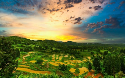
Video introduction of "Hoshitoge Rice Terraces" in Tokamachi, Niigata Prefecture This video, titled "[4K] [Original Scenery of Japan] Rice Terraces at Hoshitoge, Tokamachi, Niigata Prefecture" ([4K]【日本の原風景】新潟県十日町星峠の棚田。雲海と光芒。), was uploaded by "KYODO NEWS." In the video, you can see footage of the Hoshitoge Rice Terraces, which were selected by foreign tourists as the #1 bucket list view in Japan. The reflections on the water-filled rice fields and the sea of clouds that looks different throughout the day are captured in this beautiful 4K video. You can't help but be moved by these views. The video is accompanied by closed captions with tourist information, so be sure to turn them on while watching the video! Rice Fields in Japan Cultivation of rice fields in Japan is believed to have started during the Yayoi Period (300 BC - 250 AD). Rice has played an important role in the history of Japan, and has even been used historically as currency by farmers to pay taxes. Today, rice is a staple food in Japan, and while the exact number of rice fields in Japan is not known, according to the Ministry of Agriculture, Forestry and Fisheries, rice paddies account for 5.85 million acres of land. With Japan having a total landmass of 93.4 million acres, this means that more than 6% of Japan is rice paddies. Despite rice fields being made to grow rice, there are many places in Japan where you can see rice field art, such as Saitama and Aomori prefectures. The use of different colors of rice allows farmers to create incredible images inside the fields. Some other famous rice fields in Japan where you can see breathtaking views include the Shiroyone Senmaida Rice Terraces of Ishikawa Prefecture, the Maruyama Senmaida Rice Terraces of Mie Prefecture, and many more. Terraced rice fields prevent erosion, runoff, flooding, and other undesirable conditions, which is why they are often used in rice farming. Furthermore, they help nurture the land by allowing the water in the fields to slowly seep back into the ground, replenishing the groundwater. What Are the Hoshitoge Rice Terraces? Discover the Beautiful Scenery of Tokamachi, Niigata Photo:The Hoshitoge Rice Terraces of Tokamachi, Niigata Located in Tokamachi, Niigata, in Japan's Koshin'etsu region, the Hoshitoge Rice Terraces, numbering some 200 paddies, are spread across the hillside. Among the terraced rice fields scattered throughout the region, the Hoshitoge Rice Terraces are considered exceptionally beautiful. Depending on the weather and time of year, a sea of clouds and mirror-like water can also be seen at the rice terraces, making this a popular tourist spot with a variety of views. The Hoshitoge Rice Terraces have attracted attention both in Japan and overseas, as they were featured in the opening scene of NHK's historical drama "Tenchijin" (Heart of a Samurai) in 2009, and was recognized as a Japanese heritage that transcends borders by the Ministry of Agriculture, Forestry and Fisheries in 2022. The Hoshitoge Rice Terraces, a place where you can view the beautiful landscapes of Japan, are historic terraced rice fields created by the residents of Hoshitoge village more than 300 years ago. The area, including the village, has been selected as one of the "Top 100 Villages in Japan," and is one of Japan's leading scenic attractions. The Best Season to Visit the Hoshitoge Rice Terraces Photo:A sea of clouds over the Hoshitoge Rice Terraces, Tokamachi, Niigata One of the highlights of Hoshitoge Rice Terraces is the breathtakingly beautiful sea of clouds and mirror-like pools of water covering the fields. Unfortunately, the sea of clouds and mirror-like pools can only be seen during certain times of the year and under certain conditions. In addition, in order to capture the beautiful scenery in photographs, it's important to know in advance the best places to take photographs, so be sure to check before you visit. The best seasons for seeing a sea of clouds is during spring (late June) and autumn (mid-September). During these seasons, a sea of clouds is more likely to occur, and photographers from all over Japan flock to the area to enjoy the spectacular view. On the other hand, the best season for viewing the mirror-like pools is spring (around May to June) and autumn (around October to November). If you want to see both a sea of clouds and the mirror-like pools, be sure to visit in June. However, whether or not you can see a sea of clouds and a water mirror depends entirely on luck. The view in front of you will change depending on the conditions of the day. You will need some luck to take a good picture. However, if the conditions are right, you will be able to see a glowing sea of clouds or a scene enveloped in fog, and you will be able to capture a miraculous shot. Spring, Summer, Fall & Winter: Seasonal Views at the Hoshitoge Rice Terraces Photo:The Hoshitoge Rice Terraces covered in snow, Tokamachi, Niigata The Hoshitoge Rice Terraces are a beautiful sight in each of Japan's four seasons. In addition to the popular sea of clouds and mirror-like pools, you can enjoy colorful cherry blossoms in spring. In the summer, the rice terraces turn a deep green color and contrast with the bright blue sky. In autumn, the ears of rice shimmer with a golden glow, and in winter snow takes the place of water, creating a unique scene of pools of white snow. That being said, cars and motorcycles are unable to access the rice terraces when the snow gets too deep, and you may not be able to visit the rice fields during the winter. The Hoshitoge Rice Terraces also offer a different view during the daytime and at night. In particular, at sunrise and sunset, you can enjoy a beauty that is beyond words, no matter what season you visit in. Summary of the Hoshitoge Rice Terraces The Hoshitoge Rice Terraces are one of the most famous scenic views in Japan. It's a bucket list location, so if you're interested in visiting, we highly recommend adding it to your Niigata travel itinerary! To get to the Hoshitoge Rice Terraces in Tokamachi, Niigata, take the train to Matsudai Station and from there, it's about 20 minutes by taxi. For details on parking and directions, please check here. The rice terraces in Tokamachi, Niigata, including the Hoshitoge Rice Terraces, are not designed for the purpose of sightseeing. They are agricultural land that local people have inherited from their ancestors and carefully preserved. They are also private plots of land where farmers still cultivate rice. In addition to not entering the terraces, it's strictly prohibited to interfere with farm vehicles, take unauthorized photographs of farm work, or leave trash in the terraces. Please enjoy the spectacular scenery while observing proper manners and abiding by the rules. 【TripAdvisor】Hoshitoge Rice Terraces -
 Video article 4:31
Kamado Shrine – A Real Life Demon Slayer Location?!Introducing a popular spot for autumn foliage
Nature Travel Art & Architecture- 81 plays
- YouTube
Autumn Foliage at Dazaifu Tenmangu Shrine and KamadoShrine: Video introduction Photo:Dazaifu Tenmangu Shrine, Fukuoka Prefecture This video, titled "Dazaifu Tenmangu Shrine, Mt. Hozan|Hiking and Autumn Leaves at Kamado Shrine SONY a6500" (太宰府天満宮 Dazaifu tenmangu宝満山 登山 紅葉の竈門神社(かまど) SONY a6500), was uploaded by "Ishii Valley" (石井渓谷). The 4.5-minute video shows the beautiful autumn foliage found at Dazaifu Tenmangu Shrine and Kamado Shrine. The video provides a realistic feeling as if you were actually visiting Dazaifu Tenmangu Shrine and Kamado Shrine. Be sure to check out the beautiful autumn leaves in the video, especially around the 2-minute mark! How to Get To Homanzan Kamado Shrine From Dazaifu Tenmangu Shrine Photo:Kamado Shrine, Fukuoka Prefecture Dazaifu, located in Fukuoka Prefecture, in Japan's Kyushu region, is widely known for Dazaifu Tenmangu Shrine. However, if you visit in the fall, there's another spot that we highly recommend you visit in conjunction with Dazaifu Tenmangu Shrine. That is, Kamado Shrine. Dazaifu Tenmangu Shrine and Kamado Shrine are located very close to one another, so it's possible to visit both places in the same day. If you're going from Dazaifu Tenmangu Shrine, a 5-minute walk from Dazaifu Station, to Kamado Shrine, it will take you about 30 minutes on foot. If you use public transportation, the Mahoroba bus (まほろば号) is a convenient way to get to the shrine. Take the bus bound for Uchiyama (内山) from the bus stop Miyamae (宮前) (in front of the Sanjo 7-Eleven), and you will arrive at the last stop, Uchiyama (in front of the shrine), in about 7 minutes. Since there are not many buses, you may want to check the bus schedule in advance before visiting Dazaifu Tenmangu Shrine. On the approach to Dazaifu Tenmangu Shrine, you'll find a variety of snacks, such as umegae mochi, a specialty of Fukuoka, as well as Japanese sweets made from strawberries, and Mont Blanc. There is also a wide variety of restaurants in the area, and other stalls selling things like steamed buns. If you have time to spare, consider taking a break for lunch or a quick snack. Kamado Shrine and the Anime Demon Slayer + Popular Charms Photo:Mt. Homan, Fukuoka Prefecture Homanzan Kamado Shrine has seen an increase in the number of visitors to the shrine, due to the enormous popularity of Demon Slayer (Kimetsu no Yaiba). However, not many people know much about Kamado Shrine itself. Kamado Shrine is located at the foot of Mt. Homan, known as a sacred mountain of Dazaifu. Mt. Homan is the located in the northeast, an unlucky direction, and rituals were held here to protect Dazaifu and the nation, leading to the construction of the Shinto shrine on the site. The main deity is Tamayori-hime no Mikoto. This deity is known as a god of marriage because of her divine power to attract souls ("tama," in Japanese). In addition, the shrine is also blessed with the power to ward off bad luck and evil spirits. It's said that the shrine's popularity was sparked by the fact that the surname of Tanjiro Kamado, the main character of Demon Slayer, is the same as that of the Kamado Shrine. The shrine is said to have been named after Mt. Homan, the mountain on which it stands, because of its shape, which resembles a kamado (a type of traditional Japanese stove). As mentioned above, the fact that the shrine was built to ward off demons is also a point of interest to fans of Demon Slayer. One of the most popular spots at the shrine is the amulet office. The building was designed based on the concept of "a building that will continue to be loved even 100 years from now," with pink and white as its base color, creating a modern atmosphere. When the shrine office was rebuilt, world-renowned interior designer Masamichi Katayama participated in the project, and the benches and chairs on the observation terrace were designed by Jasper Morrison. Be sure to take a look at the stylish shrine office, as it's not something you'd expect to find at a Shinto shrine. One of the most popular spots at the shrine is the amulet office. The building was designed based on the concept of "a building that will continue to be loved even 100 years from now," with pink and white as its base color, creating a modern atmosphere. When the shrine office was rebuilt, world-renowned interior designer Masamichi Katayama participated in the project, and the benches and chairs on the observation terrace were designed by Jasper Morrison. Be sure to take a look at the stylish shrine office, as it's not something you'd expect to find at a Shinto shrine. As for good luck charms, or "omamori" (お守り) in Japanese, the most popular is the ichigo omamori (いちごお守り, strawberry charm). In the old days, the four-character idiom "Ichi-go ichi-e" (一期一会), a Japanese phrase used to describe once-in-a-lifetime encounters, was used to describe a marriage or an important match, and this amulet is a prayer for such precious encounters to come true. There are many other cute charms and amulets sold at the shrine besides the strawberry charm, so consider purchasing one to commemorate your visit to the shrine. Hiking Mt. Homan, a Popular Sacred Mountain in Dazaifu, Fukuoka Photo:A hiking trail on Mt. Homan, Fukuoka Prefecture Mt. Homan, located in Dazaifu City, is a sacred mountain that has been praised since ancient times as a mountain where the gods dwell. It's a very popular mountain among hikers, many of whom visit the mountain to climb it. There are several trails for hiking Mt. Homan, but the most popular is the standard trail starting from Kamado Shrine. After passing through the Ichino-torii (first shrine gate), you'll find a full-fledged trail with stone steps. The ascent will take about 2 hours, and the descent will be a little quicker, at around 1.5 hours. Although the trails on Mt. Homan are well maintained, there are some steep points, such as "Hyakudan Ganki" (100段ガンキ), a series of 100 steep steps. Please make sure you are fully prepared for the challenge when hiking up the mountain. A breathtaking panoramic view awaits you after you reach the summit. Enjoy the cherry blossoms in spring, autumn leaves in fall, and seasonal flowers along the trail as you climb the mountain. You can also pay a visit to the Jogu (the highest point of the shrine) of Kamado Shrine, which is located at the top. The Autumn Festival at Kamado Shrine and the Best Time to See the Autumn Leaves Photo:Autumn leaves at Kamado Shrine, Fukuoka Prefecture In autumn, Kamado Shrine is enveloped in a vibrant palette of colorful. The best time to view the autumn leaves at Kamado Shrine is usually from early November to early December, with the Autumn Leaves Festival being held at the end of November. The Autumn Leaves Festival usually attracts many visitors, with stalls selling freshly picked vegetables and refreshments, flea markets selling a variety of goods, and even stalls seasonal spirits. The best time to see the autumn leaves at the shrine is at night. The contrast between the blue skies, green trees, and the bright red autumn leaves is different from the atmosphere of the shrine at night, when the autumn leaves are illuminated. Be sure to enjoy the night view from the observatory. Things to Do Near Kamado Shrine Photo:Kyushu National Museum. Fukuoka Prefecture Despite Dazaifu and Kamado Shrine being located on the outskirts of Fukuoka City, there are a number of attractions to check out in the area. Kyushu National Museum Kyushu National Museum features an Entrance Hall with a variety of facilities, and also hosts special displays, concerts, and events. There is also a Special Exhibition Hall that hosts a number of special exhibitions, a Cultural Exchange Exhibition Hall featuring regularly rotation exhibits, and Interactive Exhibition Gallery where guests of all ages can learn about Japan and countries that Japan has interacted with throughout history. Don't forget to check out the Museum Shop for souvenirs! Hours: 9:30 am - 5: 00 pm (last entry 4:30 pm). 9:30 am - 8:00 pm (last entry 7:30 pm) on Fridays and Saturdays during special exhibitions. Closed: Mondays and public holidays. If Monday is a public holiday, the museum will open and the following day it will be closed. Admission Fee: Adults: 700 yen, University Students: 350 yen, High school students and younger: Free, Seniors (70+): Free, Persons with disabilities: Free Dazaifu Amusement Park For those traveling with kids, the Dazaifu Amusement Park is a great place to relax and have fun with a family. The park roller coasters, water coasters, merri-go-rounds, petting zoos, and all sorts of activities that families can enjoy together. Additionally, there are food areas where you can grab lunch, shops for buying gifts, and even nursing facilities that can be used freely, and stroller rentals available. Hours: (Weekdays) 10:30 am - 4:30 pm, (Weekends & Holidays) 10:00 am - 5:00 pm. Closed: No regular closures. Please check the official website for more information. Admission Fee: Admission only - Adults (Middle school students and older): 600 yen, Seniors (65+): 500 yen, Children (Ages 3 to Elementary school students): 400 yen. Free ride pass - Adults (Middle school students and older): 2,900 yen, Seniors (65+): 2,800 yen, Children (Ages 3 to Elementary school students): 2,700 yen. Nearby Onsen Also located nearby are a number of onsen (hot spring) facilities. If you're looking to relax after a day of traveling or just looking to enjoy a nice warm bath, be sure to look up some hot springs in the area when visiting. Summary of Kamado Shrine, Mt. Homan, Fukuoka Prefecture Photo:Autumn foliage illumination at Kamado Shrine, Fukuoka Prefecture, Japan Kamado Shrine is located at the foot of Mt. Homan. In autumn, when the approximately 300 maple trees change color, you can see a different view of the shrine than in other seasons. Kamado Shrine is enshrined at the foot of Mt. Homan, which is revered as a mountain where the gods dwell, and we recommend that you visit the shrine not only in autumn but also in other seasons, as it's a place rich in nature. Don't forget to stop by when visiting Dazaifu Tenmangu Shrine. Also, if you're planning to climb Mt. Homan, please make sure you are fully prepared with appropriate footwear and clothing, and enjoy the spectacular view from the top. The mountain is also dotted with historical sites, such as the Gohaku Rakan (500 arhats), so be sure to keep an eye out for them as you make you way up and down the mountain. 【TripAdvisor】Kamado Shrine -
Video article 3:03
Hatchohama Beach in Kyotango, Kyoto! A Popular Surfing Spot via Powerful Aerial Footage!
Nature Travel Things to Do- 154 plays
- YouTube
Aerial video introduction of “Hatchohama Surfer” in Kyotango City, Kyoto Prefecture This video, titled "Drone Aerial View of Surfers in Hamazume and Hatchohama, Kyotango 4K" (京丹後市浜詰・八丁浜のサーファーをドローン4K空撮。Drone aerial view of surfers in Hamazume and Hatchohama, Kyotango City), was uploaded by "Office WADA." Hatchohama Beach (Hatchohama Seaside Park) – A Beach Overlooking the Sea of Japan Photo:Hatchohama Beach in Kyotango, Kyoto Overlooking the beautiful Sea of Japan, Hatchohama Beach is a popular spot for families with children, as they can play on the multipurpose grass playground and in the park. Hatchohama Beach is open from July to August, but fishing and other activities can be enjoyed in other seasons as well. Hatchohama Beach is also known as a surfing spot, with good waves in winter. Buses to the beach are available from Amino Station. If you're drive your own car, two parking lots are available at Hatchohama Seaside Park, but please note that they are closed outside of business hours (8:00 AM - 6:00 PM). Located nearby is Obama Beach, where visitors can enjoy the sea of Kyoto. In the video, you can see the entirety of Hatchohama Beach via aerial footage. [Video] 0:13 - Hatchohama Beach Hatchohama Beach Is a Popular Surfing Spot! Photo:Sunset at Hatchohama, Kyotango, Kyoto As we mentioned previously, Hatchohama Beach is a popular spot for surfers. It's especially popular in the fall and winter, when surfing is at its best. There are also websites with live cameras of the area, so you can check wave information in advance. It may prevent you from visiting during bad weather or when the waves aren't so good for surfing. In the video, you can see many surfers having fun catching waves. [Video] 0:50 – Surfers Also popular is Hamazume Beach (Yuhigaura Beach), where beautiful sunsets can be seen. The sunset over the ocean is famous in review websites, and the reddish hue of the ocean is said to be truly spectacular. It's a perfect spot for those any photographers or instagrammers. Summer Fireworks at Hatchohama Beach – A Must See Event Photo:A fireworks show The Asamogawa Minazuki Festival and Noryo Fireworks Festival held at Hatchohama Beach at the end of July are big summer events that both the town and tourists come to see. During the daytime, the mikoshi parade is held, and the highlight of the festival is the parade over the water, where the voices of the float carriers echo through the air and many people gather to watch. At night, the Noryo Fireworks Festival is held from the bank of the Asamogawa Fishing Port. You can also view the powerful fireworks from Hatchohama Beach. In May, the Self-Defense Forces also hold an event called Kyogamisaki Air Festa. This event includes an exhibition of Self-Defense Forces equipment and a program in which airplanes fly over the venue. There are also performances by a music band and a hands-on corner. This is an opportunity to experience the activities of Japan's Self-Defense Forces, which you wouldn't normally have the chance to see. Summary of Hatchohama Beach (Hatchohama Seaside Park) Hatchohama Beach can be enjoyed by day-trip tourists, but we suggest that you take advantage of opportunities like summer vacation to plan a relaxing overnight stay. There are hotels, cottages, and campgrounds in the area. For those who want to enjoy not only swimming but also the surrounding sightseeing spots and nighttime events, we recommend staying overnight. Enjoy a visit to the sea in Kyoto and make your summer vacation a memorable one. The beautiful scenery is sure to satisfy people of all ages. If you still haven't yet, be sure to check out the aerial video of Kyotango's beaches! 【Official Website】Hatchohama Beach – Visit Kyotango, Kyoto's Getaway|Kyotango City Tourism Association https://visitkyotango.com/things-to-do-spot/hachohama-beach/ 【TripAdvisor】Hatchohama Beach – Obama Beach https://www.tripadvisor.com/Attraction_Review-g1023401-d1424604-Reviews-Hacchohama_Kobama_Beach-Kyotango_Kyoto_Prefecture_Kinki.html -
Video article 3:52
4K video of the autumn leaves swaying in the wind at Engo-ji Temple in Kyoto City, Kyoto Prefecture, a temple associated with Tokugawa Ieyasu! Includes the time of autumn foliage, highlights, and nearby sightseeing spots.
Nature Travel Art & Architecture- 85 plays
- YouTube
Movie introduction of autumn leaves at Enko-ji Temple in Kyoto City, Kyoto Prefecture This video, titled "[4K] 2021 Autumn Leaves and Suikinkutsu at Enkoji Temple, Kyoto" (【4K】2021圓光寺の紅葉と水琴窟 Autumn leaves of Kyoto Enkoji Temple), was uploaded by "fuppomadoka1962." Enjoy the 4K video that will have you feeling like you're actually walking through the garden of Enkoji Temple, and experience the autumn leaves dancing in the light to the faint sound of a suikinkutsu. Highlights of Enkoji Temple in Northern Kyoto Photo:Autumn leaves at Enkoji Temple, Kyoto The reason for the overwhelmingly beautiful autumn leaves at Enkoji Temple is its location. Located in the northern part of Kyoto City, Enkoji Temple is characterized by colorful autumn leaves every year due to the extreme temperature differences between the four seasons. The highlight of Enkoji Temple's autumn foliage is the garden Jugyu no Niwa (十牛の庭, lit. "The Garden of Ten Oxen"), where visitors can view the leaves from various vantage points. [Video] 0:50 - The Beautiful Garden Jugyu no Niwa [Video] 1:30 - Jugyu no Niwa Seen From the Exhibit Hall Photo:The chozubachi at Enkoji Temple, Kyoto A suikinkutsu is a Japanese garden ornament that makes a lovely sound. The suikinkutsu in the garden of Enkoji Temple is made of a wide-rimmed chozubachi (手水鉢, water bowl), a shape not seen anywhere else, and has been cherished by hobbyists as the "Enkoji style" since ancient times. The vivid autumn leaves on the surface of the water sway in the wind, making it a popular scene for photographers and instagrammers. After snapping some photos of the beautiful autumn leaves, visitors can enjoy listening to the sound of the suikinkutsu. The sound of water dripping into the hollow of the pot, which is embedded in the ground, is similar to the sound of a koto (the Japanese harp), and it resonates in the hearts of those who hear it. [Video] 3:30 - The Faint Sound of the Suikinkutsu The history of Enkoji Temple dates back to 1601, when the famous warlord Tokugawa Ieyasu built Enkoji Temple in Fushimi and turned it into a school to promote education and learning in Japan. The temple also exhibits some of the oldest wooden typefaces in Japan (an Important Cultural Property), and has a history tracing back to the origins of printing in Japan. From the hilltop of the Toshogu Shrine on top of the mountain, visitors can enjoy the view of Arashiyama and Kitayama, and at dusk, the golden hour envelops the whole area, offering a spectacular view that changes with every passing moment. Enkoji Temple is also home to a bamboo forest path, which is said to have been frequented by Maruyama Okyo, a Japanese painter active in Kyoto during Japan's Edo period (1603-1868 AD). His painting "Bamboo in Wind and Rain" (an Important Cultural Property) is also on display at the temple. Reservations and When to View the Autumn Leaves at Enkoji Temple Photo:Autumn leaves at Enkoji Temple, Kyoto In recent years, special viewing of autumn leaves at Enkoji Temple has been reserved for a designated date and time to avoid congestion.For reservations and details regarding reservation start times, viewing periods, times, and viewing fees, please check the advance reservation page on the official website. The best time to view the autumn leaves is usually from mid-November to early December, although times may vary slightly due to climate change and temperature fluctuations over the past few years. The Jizo statues, which can be seen as soon as you enter Jugyu no Niwa, are also popular. During the autumn foliage season, the Jizo statues standing on a carpet of autumn leaves is great for taking photos and attracts many instagrammers. "Early morning viewing" is popular among people who want to avoid crowds during the peak season of autumn leaves, which can be visited before normal viewing hours on certain days when autumn leaves are at their best.In 2023, only the first 40 people applied.If you want to enjoy the autumn leaves in a quiet time from eight o'clock in the morning, please check the official website in advance next year. Autumn Foliage Spots Around Enkoji Temple in Northern Kyoto Photo:Autumn leaves at Shisendo, Kyoto The area around Enkoji Temple, in northern Kyoto, is home to many places for enjoying the autumn leaves, as well as popular tourist attractions. Many visitors to Enkoji Temple visit Shisendo, another Buddhist temple, where they are able to escape from their frantic daily lives and enjoy a moment of tranquility. At Sanzenin Temple, a representative temple of Ohara, visitors can enjoy a spectacular collaboration between the green mosses and crimson maple leaves. In addition, Manjuin Temple, the Kibune Foliage Lantern Festival (貴船もみじ灯篭, Kibune Momiji Toro), and Hosen'in Temple have gained popularity in recent years as spots where visitors can enjoy the illuminated autumn leaves. Summary of Autumn Leaves at Enkoji Temple, Kyoto The northern Kyoto area, where Enkoji Temple is located, is famous for its autumn leaves, which attract many tourists from both Japan and other countries during the autumn foliage season. The crowds are part of the fun of a sightseeing trip for many people, but for those looking to avoid the crowds and enjoy the autumn leaves in peace, we recommend waking early and getting to the temple at the earliest possible time. As they say, your trip starts from the moment you start planning, so don't forget to look up information in advance to enjoy the popular autumn foliage season in Kyoto. We hope you enjoyed experiencing some of the beauty of Kyoto in autumn and get the chance to experience it firsthand! ◆Enkoji Temple◆ 【Address】13, Ichijojikotani-cho, Sakyo-ku, Kyoto-city, 606-8147, Japan 【Hours】9:00-17:00 【Admission Fee】Adults ¥500, Junior high and high school students ¥400, Elementary School students ¥300 【Parking】Available 【Access】 A 10-minute walk from the Ichijoji Sagari-Matsu (一乗寺下り松) bus stop A 15-minute walk from Ichijoji Station on the Eizan Electric Railway's Eizan Line 【Official Website】Zuiganzan Enkouji Temple https://www.enkouji.jp/ 【TripAdvisor】Enkoji Temple https://www.tripadvisor.com/Attraction_Review-g298564-d1386150-Reviews-Enkoji_Temple-Kyoto_Kyoto_Prefecture_Kinki.html -
Video article 11:32
The Yaeyama Islands: Scuba Diving, Snorkeling, and Other Things to Do on the Islands of Okinawa, Japan!
Nature Travel- 72 plays
- YouTube
The Yaeyama Islands, the Pride of Okinawa: Video Introduction This video, titled "[4K] Spectacular Aerial Views: Yaeyama Islands, Okinawa (Ishigaki Island, Hatoma Island, Aragusuku Island, Kuroshima Island, Iriomote Island)" (【沖縄/石垣島/竹富島/浜島/幻の島】石垣島観光スポット 絶対行くべき幻の島(浜島)), was uploaded by "AQUA GeoGraphic," a channel that mainly uploads underwater videos of Japan, as well as nature videos and other clips of Japan and abroad. In this video, you will see the spectacular view of the sea of the Yaeyama Islands. Where Are the Yaeyama Islands? The Yaeyama Islands are a group of 12 islands, including Ishigaki Island, Taketomi Island, Kohama Island, Kuroshima Island, Aragusuku Island, Iriomote Island, Hateruma Island, and Yonaguni Island. They occupy one fourth of the total area of Okinawa Prefecture. Check out the aerial and underwater footage of the beautiful sea of the Yaeyama Islands in the video! Kabira Bay – A Scenic Location 40 Minutes From New Ishigaki Airport Photo:Kabira Bay, Ishigaki Island Kabira Bay is located about 40 minutes away from New Ishigaki Airport, the gateway to the Yaeyama Islands, by car. The color of the sea changes depending on the time of day you view it from, and the scenery afforded by the uninhabited islands scattered throughout the bay is simply breathtaking. The view of the bay has been selected as one of the "Top 100 Landscapes of Japan." The Beauty of Kabira Bay has earned it three stars in the Michelin Green Guide Japan. Popular Scuba Diving Spots on Ishigaki Island! Photo:Scuba diving on Ishigaki Island, Okinawa There are many beautiful scuba diving spots and must-see locations around Ishigaki Island. Here are a few places we recommend checking out: ・Kabira-Ishizaka Manta Scramble (川平石崎マンタスクランブル) - A place scuba diving spot where you can dive with manta rays ・Yoshiwara Arch (吉原アーチ) - A fantastical underwater scuba diving spot where the light shines beautifully through the exit of the arch ・Jukabijin (樹下美人) - A tree-shaped root with schools of fish dancing around it ・Arakawa Double Arch (荒川Wアーチ) - An arch with two tunnels, crevasses, and other terrain ・Yonehara Double Reef (米原Wリーフ) - A scuba diving spot that can be enjoyed by beginners and expert divers alike These are only some of the scuba diving spots you can find on Ishigaki Island, but there are many more. Things to Do on Hatoma Island – A Lesser-Known Destination in Okinawa Hatoma Island is a small island with a population of just 50 people. Although the island does not attract as many people as other tourist sites, it's a place where humans and animals coexist in harmony. With beautiful sandy beaches and coral reefs there's plenty to enjoy here. You can even see wild goats in town. Both children and adults can enjoy snorkeling on the sandy white beaches. Legends of Mermaids on Aragusuku Island Photo:Aragusuku Island, Taketomi, Okinawa Aragusuku Island is said to have once been inhabited by dugongs, and you can even find Ningyo Shrine (人魚神社, lit. 'Mermaid Shrine') on the island that only islanders are allowed to enter. It's a mysterious island with many other forbidden areas. Aragusuku Island consists of two islands, Kamiji Island and Shimoji Island, which are not accessible by regular boats and can only be reached via tours departing from Ishigaki Island or Iriomote Island with local guides. The islands are known as snorkeling spots where you can enjoy nature. Things to Do on Kuroshima Island – A Unique, Heart-Shaped Island With Fresh Air, Sea Turtles, and More! Photo:Kuroshima Island, Okinawa Kuroshima Island is known as "Heart Island" because of its heart-like shape. It is also known as a nesting ground for sea turtles, and the island is home to the Kuroshima Research Institute, which researches sea turtles and other marine life. Interestingly, the cow population on Kuroshima is 10 times that of the human population, so visitors can enjoy a magnificent view of cows dotting the landscape. Visitors also can enjoy swimming and snorkeling at Nakamoto Beach, located on the west side of the island. Jungle Tours and Cave Exploration on Iriomote Island, the Last Unexplored Island in Japan Photo:A jungle tour on Iriomote Island, Okinawa Iriomote Island is referred to as "the last unexplored island in Japan" and is covered with pristine subtropical virgin forests and mangrove forests at many river mouths. Iriomote Island offers many activities to enjoy its great nature, including scuba diving, kayaking, spelunking, and jungle trekking tours. Other Things to Do on the Yaeyama Islands! Photo:A starry sky from the Yaeyama Islands In addition to the islands mentioned above, there are several other remote islands in the Yaeyama Islands which have their own charms. Hateruma Island, the southernmost inhabited island in Japan, is home to the beautiful sea dubbed Hateruma Blue and starry skies, which are a prime location for stargazing. To get to Hateruma Island, you'll have to take a high-speed boat (ferry) from Ishigaki Island. Taketomi Island, a small island southwest of Ishigaki Island, is a popular remote island where you can fully experience the tropical atmosphere of Okinawa. The buffalo cart tour, which takes you to traditional Okinawan houses with red-tile roofs, banyan trees, coral trees, and other seasonal flowers, all while listening to Okinawan folk songs played by the guide, is extremely popular. Kohama Island, located on the east side of Iriomote Island, is one of the leading resort areas in the Yaeyama Islands. Although Kohama Island is home to famous resort hotels, much of the nature on the island remains untouched, and there is even a famous road called Sugar Road that passes through the middle of sugar cane fields. It's a popular location that has been used in many Japanese television dramas. Yonaguni Island, Japan's westernmost island, is full of attractions, such as Tategami Rock (Standing God Rock) and Gunkan Rock (Battleship Rock). Yonaguni Island is also home to a hill where you can view the last sunset in Japan each day, as well as spots that are thought to be underwater ruins. In addition to scuba diving, you can enjoy glass boat and snorkeling tours as well. In addition, tourists to Yonaguni Island can purchase souvenirs in the souvenir store at Yonaguni Airport to commemorate their trip to the island. For example, you can buy hanasake (a special type of spirit, made only on Yonaguni island, with 60% alcohol content), as well as straps and drawstrings made of Yonaguni ori (Yonaguni brocade), a vivid fabric with 500 years of history. How to Get to the Yaeyama Islands & Visiting Other Islands: Ferry Schedules + Prices As we mentioned above, New Ishigaki Airport is the gateway to the Yaeyama Islands. As such, visitors to the island will need to travel to the island by plane. Flights are available from all major airports in Japan, including Tokyo, Osaka, Kyoto, and Okinawa. Flight prices and times will vary by location. In the past, there was a ferry from Naha that took visitors directly to the Yaeyama Islands, but the service was discontinued in 2008. After you've arrived on Ishigaki Island, you can visit the other islands via ferry. Most islands have regularly scheduled ferries, but some islands have just 1-2 ferries scheduled each day, so we recommend looking up ferry timetables before visiting. Please also keep in mind that because travel time to each islands varies, so to do ferry ticket prices. Round trip tickets can cost anywhere from 1,500 yen (~10 USD) to 6,000 yen (~42 USD). Summary of the Yaeyama Islands, Okinawa If you haven't already watched the video, be sure to take a look at it, as you can see incredible aerial views of the islands in Okianwa, Japan. The Yaeyama Islands are a place where you can enjoy untouched nature, as well as scuba diving and snorkeling in crystal clear waters. The Yaeyama Islands also offer a unique cultural experience, different than you'll find on mainlaind Okinawa. With all this in mind, what are you waiting for?! Plan your trip to the Yaeyama Islands! 【Trip Advisor】Okinawa, Japan -
Video article 3:04
Cherry blossoms in full bloom covering the entire area are truly spectacular! Rokudo no Tsutsumi" in Ina City, Nagano Prefecture, was a hidden cherry blossom viewing spot that I wanted to visit at least once!
Nature- 1.69K plays
- YouTube
Cherry blossom video introduction of "Rokudo no Tsutsumi" in Ina City, Nagano Prefecture This video, titled "[ 4K UltraHD ] 六道堤の桜 - Cherry Blossoms at Rokudo Bank - (shot on Samsung NX1)," was created by "AQUA Geo Graphic." This three-minute video captures a stunning view of the sea of cherry blossoms at Rokudo Bank Normally, when thinking of the Koshinetsu region or the Nanshin region of Nagano Prefecture (甲信越地方・長野県南信地方, koshinetsu chiho・nagano-ken nanshin chiho), the area best known for cherry blossoms would be Takato Castle Ruins Park (高遠城址公園, takato joshi koen). This park is one of the three great cherry blossom spots in Japan, known for having "the best cherry blossoms under the heavens." However, another special spot, known only to locals, exists in Ina City (伊那市, ina-shi). Enjoy the beautiful cherry blossom viewing spots of Nagano Prefecture in the video. Rokudo Bank, Nagano Prefecture Photo:Cherry blossoms at Rokudo Bank Rokudo Bank is just 10 minutes from Takato Castle Park by car. Though a hidden spot, it's known to have cherry blossoms every bit as beautiful as those in the main park. The snow-tipped peaks of the Kiso Mountains can be seen from 0:36 to 1:55 in the video. Because Ina City in Nagano Prefecture is at a high elevation and surrounded by mountains, the cherry blossom season tends to be a bit late, but cherry blossoms are usually at their best from early to mid-April. The Cherry Blossoms of Rokudo Bank Photo:Cherry blossoms at Rokudo Bank The reservoir is surrounded by approximately 120 takato-okuhigan cherry trees. The sight of the sea of cherry blossoms in full bloom stretching as far as the eye can see is nothing short of breathtaking. On days when the weather is nice, the cherry blossoms are reflected on the surfaces of the water, creating a dream-like scenery. Definitely take some pictures to post on your Instagram! You can see this beautiful scenery in the video as well. As seen at the beginning of the video, there is a little island of red pines in the middle of the reservoir. This adds to the Japan-esque scenery. You can also see two cute ducks swimming peacefully through the cherry blossoms at 1:23 in the video. In addition to the full bloom period, another great time to visit is when the cherry blossoms began to scatter with the wind as the season begins to end. Summary of Rokudo Bank Photo:Cherry blossoms at Rokudo Bank In this article, we introduced Nagano prefecture’s hidden gem- the cherry blossoms of Rokudo Bank. This place is loved dearly by locals for its beautiful scenery. Of course, the historical Takato Castle Park is known for its stunning cherry blossoms as well. If you have the chance to visit Ina City in Nagano Prefecture, we definitely recommend checking out the blooming forecast before going. ◆Rokudo Bank◆ 【Address】Misuzu, Ina City, Nagano Prefecture 【Access】A 15-minute drive from Ina-Kita Station on the Central Japan Railway Iida Line 【Parking】Available(Free・5 Spaces) 【Official Homepage】Ina City Tourism Association -
Video article 7:51
Spend the Holidays in a Resort Atmosphere With the Crystal Clear Waters of Iheya Island, Okinawa! The Beautiful Blue Sea Is Called "Iheya Blue"!
Nature- 185 plays
- YouTube
Iheya Island, a Remote Island of Okinawa This video, titled "Beautiful Beach of Iheya Island! OKINAWA, JAPAN" (伊平屋島(沖縄離島)の絶景ビーチ前篇!OKINAWA,JAPAN), was uploaded by "K Japan Traveler." It shows spectacular views of Iheya Island (伊平屋島, Iheyajima), Noho Island (野甫島, Nohojima), and Izena Island (伊是名島, Izenajima), which are in northern Okinawa. As you can see in the video, Iheya Island has a beautiful cobalt blue ocean that you would never expect to find in Japan. A Look at Iheya Island Photo:Brown sugar, Okinawa Iheya Island is a long, narrow island located approximately 41 km north of the main island of Motobu, with a population of about 1,400 people including those on Noho Island. The island has specialties, such as dried fish, hitokuchi brown sugar, Terushi Rice, and Kachiwari brown sugar. There's also Kitase Rock, Yahe Rock, and a skerry called Erabu Rock around Iheya Island. "Torazu Rock" is a landmark of the island. You should visit Koshino Hiramatsu, Nento Hiramatsu and Mt. Kuba too. Things To Do on Iheya Island Photo:The ocean at Sugahama, Okinawa We recommend going sightseeing via rental car. The clear beaches, such as Kumaya Coast, Yonezaki Beach, Shioshitahama, and Kubayama Beach are the best place for sea bathing and fishing. From 0:37 in the video, you can see Kouri Island and Kouri Bridge, and from 1:40 in the video, you can see Noho Bridge, Noho Port, and a beautiful view. For sightseeing, there's Kumaya Cave, Iheya Tower, the Iheyason Board of Education History Ethnic Museum, Kubayama Light House, and Kami Ashagi. You can enjoy activities like the salt cruise at the World Salt Exploration Museum. For snorkeling to see coral reefs, book with Diving service North Island or Diving Shop JIN. Access to Iheya Island Photo:The ocean at Iheya Island, Okinawa Unfortunately, it's somewhat difficult to reach Iheya Island. You have to go from Naha Airport, on the main island of Okinawa, to Nakijin, and then take a ferry for 80 minutes. Because of that, there are not so many tourists, which means you can enjoy the natural scenery all to yourself! As you can see from 1:17 in the video, you can enjoy "Iheya Blue," a clear, blue sea, different from the main island of Okinawa. There are several hotels and restaurants on the island, so you can stay overnight as well as take a day trip, and there are buses running around the island, so as long as you check the bus schedules it's not so bad. Summary of Iheya Island Photo:The ocean at Iheya Island, Okinawa Iheya Island has beautiful beaches where you can feel the refreshing sea breeze. Check out the time schedule for the ferry, as well as prices and information about tides when you visit the amazing resort, Iheya Island! 【Tripadvisor】Iheya Island https://www.tripadvisor.com/Attraction_Review-g1121620-d1373491-Reviews-Iheyajima_Island-Iheya_son_Shimajiri_gun_Okinawa_Prefecture.html -
Video article 3:26
The Beauty of Mie Prefecture's Tea Plantations Will Blow You Away! Introducing the Popular Tea of Mie Prefecture, the Third Largest Producer of Tea in Japan!
Nature- 197 plays
- YouTube
Mie Prefecture's Tea Plantation! There are many tea plantations around Japan. In this article, we'll introduce the tea plantations of Mie prefecture alongside a 4K video. The video, titled "Mie Green Tea Fields - 4K Ultra HD," was created by "TokyoStreetView – Japan The Beautiful." The video introduces a famous tea called "Isecha" (伊勢茶), that's produced in Mie prefecture. The Kamize tea plantation by the Miyagawa river in the Odai Sankei area of Mie prefecture's Taki district is famous for producing high quality Japanese tea. Don't miss out on the beautiful scenery of the paddy fields and green tea plantations in this video! The History and Types of Tea Plantations in the Video Photo:A tea plantation in spring Isecha is thought to have been grown in Mie Prefecture for over 1,000 years. It's said that from the Muromachi period (1336-1573 AD) to the Edo period (1603-1863), priests and merchants carried Isecha to all corners of Japan. Japanese tea leaves are picked from shrubs, such as those seen at 0:41 in the video. The Japanese tea leaves harvested from the tea plantations are sorted into a variety of types, depending on how they were cultivated and processed. These varieties include teas such as Sencha (煎茶), Kabusecha (かぶせ茶) and Gyokuro (玉露). When Is Japanese Tea Harvested and How Can You Purchase It? Photo:Tea plantation・Tea picking Tea farmers in Japan pick the first tea of the year around May. An event is held at the Kamize tea plantation (introduced in the video) where leaves are picked to be used as an offering to Ise Grand Shrine. Japanese tea can be purchased at either tea shops in the area or online. There are also many cafés where you can try a variety of Japanese teas and traditional sweets. The Top Tea Producing Areas in Japan! Photo:Green tea and tea leaves Areas famous for tea production in Japan include the Mount Fuji area of Shizuoka prefecture, Kyoto prefecture, Miyazaki prefecture, and Kagoshima prefecture. The Kamize and Suizawa (水沢) tea plantations of Mie prefecture are also known for producing high quality Japanese tea. The largest producers of tea in Japan (based on production volume, production cost, and cultivation area) are ranked as follows: No.1 – Shizuoka prefecture No.2 – Kagoshima prefecture No.3 – Mie prefecture Summary of Mie Prefecture's Tea Plantation Photo:Tea plantation We hope you enjoyed the view of the beautiful tea plantations introduced in the video. During the peak of the tea growing season, the tea plantations in Mie prefecture, in areas such as Suzuka Yokkaichi, Oku Ise Odai, and Suizawa, create some incredible scenery. At 2:17 in the video, you can see the beautiful scenery of the tea plantations surrounded by mountains. In the Ise-Shima area you can also see the amazing single cherry blossom tree known as "Iwatozakura" (岩戸桜). If watching this video has sparked your interest in Japanese tea, we highly recommend visiting a tea plantation during the height of the tea season to enjoy some amazing sightseeing and delicious tea! -
Video article 2:14
Kamiike Pond Is a Mysterious Pond Surrounded by the Sea, Yet Filled With Freshwater Carp. Enjoy the Beauty of This Tourist Destination in Shizuoka, One of the Seven Wonders of Izu, Whose Mysteries Have Yet to Be Solved!
Nature- 276 plays
- YouTube
Aerial video introduction of "Ose Myojin no Kamiike" in Numazu City, Shizuoka Prefecture This video, “絶景空撮 大瀬崎 神秘の自然と信仰の岬 - Aerial view of Cape Osezaki - Secret nature and religious cape -」,” is an aerial video of Cape Osezaki’s Kamiike Pond, located in the bayside of Numazu city, Shizuoka prefecture, produced by “FUJISAN DRONE BASE.” Osezaki is a cape in Numazu city, Shizuoka prefecture, extending into Suruga Bay, and is also called the Ose no Kami Pond of Ose Myojin, or Biwa Island. As shown at 0:50 in the video, you can see the great view of Mt. Fuji over the sea from Osezaki Kamiike Pond. What Kind of Sightseeing Spot Is Osezaki Kamiike Pond? Photo:Osezaki Kamiike, Numazu City, Shizuoka Prefecture As seen in the video at 0:15, Osezaki features the beautiful Kamiike Pond, with the longest part of the pond being about 100 meters wide. Osezaki’s Kamiike Pond is called an "unexplored area," "mysterious spring," and is a mysterious spot considered one of the seven wonders of Izu. Although Ose Myojin’s Kamiike Pond is located at the tip of a cape, it's a fresh water pond, and fresh water fish, such as carp, call this pond home. It is said that Mt. Fuji’s underground water pours into Ose Myojin’s Kamiike Pond, but the mystery of Ose Myojin’s Kamiike Pond has yet to be solved. The water quality and depth are also unknown. Let’s Visit Ose Shrine in Osezaki! Photo:Osezaki and Ose Shrine Around the Osezaki Kamiike Pond are many large juniper trees with thick foliage. Osezaki’s juniper forest has been designated a Natural Monument. Hikitechikara no Mikoto (Ose Shrine) seen in the video at 1:14, is located at the peak of Osezaki, with an elevation of approximately 10m, and is called the protectorate god of the sea. Other highlights include a sacred tree said to be 1,500 years old, a pair of iron geta (sandals) dedicated near the torii gate, and a strange fan made of tengu leaves derived from the legend of tengu. Sightseeing Around Osezaki’s Kamiike Pond Photo:Clownfish Around the scenic Osezaki is the Ose beach, which is one of Japan’s “Top 100 Beaches.” Spending time listening to the waves and taking in the sunset is very relaxing. Osezaki is also popular as a diving spot, and many divers visit here during the on season. Osezaki is also known as a fishing spot, but collecting animals and plants around Kamiike Pond is prohibited by the Cultural Assets Preservation Act, so be careful not to break any laws. Summary of Ose Myojin’s Kamiike Pond Source :YouTube screenshot Shizuoka prefecture’s Osezaki Kamiike Pond area, introduced in the video, is a nice Instagram spot where you can see the beautiful sea and Mt. Fuji. There are many sightseeing spots in Izu, book a hotel nearby and visit Osezaki. In the spring time, cherry blossoms bloom nearby as well. We also recommend participating in a tour visiting Ose Myojin’s Kamiike Pond and the nearby area. ◆Hikitechikaranomikoto Shrine (Ose Shrine) General Information◆ 【Address】329, Nishiura Enashi, Numazu city, Shizuoka, ZIP 410-0244 【Access】80 minutes by bus from JR Numazu Station 【Admission fee】100 JPY 【Hours】8:30-17:00 【Parking】Available 【Telephone】055-942-2603 【Tripadvisor】Ose Myojin’s Kamiike Pond https://www.tripadvisor.com/Attraction_Review-g1019668-d1313552-Reviews-Ose_no_Kami_Pond-Numazu_Shizuoka_Prefecture_Tokai_Chubu.html -
Video article 3:30
The Cherry Blossoms at the Hirosaki Cherry Blossom Festival in Hirosaki, Aomori, Said to Be the Best in Japan, Are Sure to Look Great on Instagram! Enjoy the Cherry Blossom Festival With 3 Million Visitors, Where 'Hatsune Miku' Was Appointed as the Official Supporting Character!
Nature- 428 plays
- YouTube
青森県の日本一の桜まつり「弘前さくらまつり」を紹介 こちらの動画は「shota odagiri」さんが公開した「SAKURA 日本一の桜まつり青森県弘前市【HD】」です。 日本の春を代表する桜! 青森県弘前市にある弘前城周辺でおこなわれる弘前さくらまつりはソメイヨシノを始めとして数々の桜が百花繚乱のごとく咲き乱れ、毎年弘前公園には全国から訪れる数多くのお花見目当ての観光客で賑わいます。 本州最北端の地、青森県で咲く桜 桜前線の北上に伴い青森県弘前城周辺では4月下旬頃に開花予想が出されます。 弘前公園内には、ソメイヨシノを中心に、シダレザクラ、八重桜など、約50種類2,600本の桜が咲き誇ります。 日本一と言われる弘前さくらまつりの桜たちは一つの花芽からいくつもの花が咲き、もこもこの迫力のある花付きが特徴と言われています。 弘前さくらまつりの終盤になると弘前城周辺のお堀にはたくさんの桜の花びらが浮かび、この光景を「花筏(はないかだ)」「桜の絨毯」と呼び、壮大な景観の花筏が楽しめます。 2019年から2年間は弘前さくらまつり公式応援キャラクターにボーカロイドの「桜ミク(初音ミク)」が選ばれ、祭りをより一層盛り上げています。 弘前さくらまつり情報紹介 弘前市は青森県最大の都市で四季折々の自然が楽しめる観光地です。 春は桜、夏のねぷた祭り、秋は菊と紅葉が特に有名で、この弘前さくらまつりの日程は毎年4月23日〜5月5日の期間に開催されています。 弘前さくらまつりは非常に長い歴史があり1889年から続く伝統のお祭りです。 期間中は日没から23時までライトアップされ夜桜見物を楽しむ観光客であふれます。 弘前さくらまつりには出店や屋台もたくさん並びますので絶景とグルメを一緒に楽しむことができます。 弘前さくらまつりが開かれている弘前公園までのアクセスは以下のとおりです。 ・東京からお越しの方:東京→はやて(3時間20分)→新青森→特急つがる(30分)→弘前→路線バス「弘前公園」下車 ・大阪からお越しの方:大阪→のぞみ(2時間30分)→新青森→東京→はやて(3時間20分)→新青森→特急つがる(30分)→弘前→路線バス「弘前公園」下車 ・羽田空港から飛行機でお越しの方:羽田空港(1時間15分)→青森空港→バス(55分)→弘前路線バス「弘前公園」下車 ・伊丹空港から飛行機でお越しの方:伊丹空港(1時間30分)→青森空港→バス(55分)→弘前路線バス「弘前公園」下車 なお駐車場は完備されていますが、大変混雑いたしますので弘前駅からバスをご利用ください。 弘前さくらまつり期間中は20:00まで特別便を増発して運行します。 弘前さくらまつり紹介まとめ JR弘前駅ではおすすめ情報満載の観光ガイドを無料配布していますのでご活用ください。 また全国の旅行代理店で弘前さくらまつりツアーが催行されますのでホテルと交通がパックになったお得な観光ツアーをご利用ください。 是非日本一の桜を弘前さくらまつりでお楽しみください。 -
Video article 2:36
Japan's Traditional Terraced Rice Fields. A Look at the Beautiful Terraced Paddies of Hiratsuka, Chiba!
Nature- 360 plays
- YouTube
Kamogawa Oyama Senmaida" in Kamogawa City, Chiba Prefecture, a one-day trip from Tokyo, video introduction This video, titled "Chiba Hiratsuka terraced rice field - 棚田 - 4K Ultra HD," was released by "TokyoStreetView - Japan The Beautiful." Have you ever seen a terraced rice field? Many people think that you have to go to Niigata or other places in Japan's Tohoku region to see terraced rice fields. The video introduces the beautiful terraced rice fields of Kamogawa, Chiba a place easily accessible from Tokyo. Let's take a look at some of Japan's beautiful landscapes in the video! The Oyama Senmaida Terraced Rice Fields Photo:The Oyama Senmaida Terraced Rice Fields, Chiba Prefecture The Oyama Senmaida Terraced Rice Fields, featured in the video, is famous for being the closest terraced rice field to Tokyo. The area is 3.2 hectares, with more than 375 paddies extending across the hillside. Even today, many rice paddies are used for farming and this scenery can be said to be a classic Japanese landscape. Light-up event “Tanada no Akari” in Oyama Senmaida In addition to rice production, a viewing spot and observation floor are created, and the “Akari in the Terraced Rice Paddies” lighting event using 10,000 LED candles is usually held from late October to January each year. The 2024 event will be held from October 26 to January 13, 2025, from approximately 5:00 p.m. to 8:00 p.m. Admission is free. The beautiful scene of a sunrise created between the paddies at 0:31 is something that not even a high-quality video can do justice to. The Terraced Rice Fields Found All Over Japan Photo:Rice fields and mountains in rural Japan Many of Japan’s rice fields are built on an inclination. This has the advantage of allowing for easy water control and improved rice production. One drawback, however, is that these are stair-stepped on steep slopes with land that is difficult to drain due to narrow cultivation units, and there are many places with no successors. The Ministry of Agriculture, Forestry and Fisheries (MAFF) has designated 100 of the 134 terraced rice fields across Japan as the "Top 100 Terraced Rice Fields of Japan" in order to maintain the terraced rice fields and stimulate tourism in those areas. Although the word "terraced rice paddies" is used to describe the fields, the shape and characteristics of each paddy differs from place to place, so traveling across Japan to explore the different scenery of each area can make for a fun road trip! Many of these places have reputations for their Instagrammable and photogenic scenery as well. Famous Places to visit on Chiba Prefecture's Boso Peninsula Photo:Walruses at Kamogawa Sea World, Chiba Prefecture The Boso Peninsula in Chiba Prefecture, is home to the Oyama Senmaida Terraced Rice Fields. It can be easily accessed from Tokyo by JR limited express trains, express buses, and the Tokyo Bay Aqualine. On Boso Peninsula, many tourists visit Kamogawa Sea World, Mother Farm, and go swimming during the summer. In addition to the Oyama Senmaida Terraced Rice Fields, Boso Peninsula has many other sightseeing spots that make it an excellent travel destination. Summary of the Oyama Senmaida Terraced Rice Fields Photo:Oyama Senmaida Terraced Rice Fields, Chiba Prefecture We hope the beautiful scenery of the rice fields in the video provided a relaxing atmosphere. There are many terraced rice fields that can be found across Japan, so be sure to do some research before your trip to find one that you can visit! If you live in Japan you can also use the “owner system” to become the owner of a beautiful rice field and grow your own rice! 【Tripadvisor】The Oyama Senmaida Terraced Rice Fields https://www.tripadvisor.com/ShowUserReviews-g1021271-d1944760-r554882939-Oyama_Rice_Terraces-Kamogawa_Chiba_Prefecture_Kanto.html -
Video article 2:53
Is Tojinbo in Sakai City, Fukui Prefecture, a sacred place for suspense drama fans? The power spot on the precipitous cliff with a spectacular view is a thrilling experience!
Nature Travel- 177 plays
- YouTube
Tojinbo" in Sakai City, Fukui Prefecture Video Introduction Tojinbo, in Fukui prefecture, located in Japan's Hokuriku region, is a series of vertical cliffs created by the rough waves of the Japan Sea. It is a rare type of sea cliff which can only been seen in 3 other places in the world. This video, titled "(4K) Aerial Drone Footage / Flown in Tojinbo in Sakai City, Fukui Prefecture" (【4K】福井県坂井市 東尋坊で飛ばしてみた / ドローン空撮), was produced by "Mattsu." The video shows the exposed rock face and jagged landscape of Tojinbo via aerial drone footage. The geological composition of the cliffs of Tojinbo is made up of pyroxene andesite and some of the cliffs tallest points are approximately 25m tall. Its strangely shaped pillars extend for 1km and it has been designated a Natural National Monument and Scenic Spot, and is also a part of the specially protected area of Echizen-Kaga Kaigan Quasi-National Park. It is also one of the world's 3 most geologically rare scenic spots, and therefore it is well known around the world. The origin of the name Tojinbo is said to have come from the name of a monk "Tojinbo" who lived long ago and was affiliated with Heisenji Temple and lost his life after being thrown off the cliff in a romantic tangle. After Tojinbo was thrown into the sea; another monk, his rival in love, was also pulled into the rough waves and tempestuous weather continued for 49 days. Or so the legend goes anyways... It is also famous for being used as a film location for climactic scenes in which the culprit tries to throw him or herself into the sea after making a confession in suspenseful TV dramas or movies. Tourist Attractions Around Tojinbo Photo:Tojinbo, Fukui Prefecture The Tojinbo cliffs, which is a rare rock formation even outside of Japan, is a famous place that even many Japanese would like to visit at least once. In order to preserve Tojinbo's amazing view there are no safety features such as fences installed there. You are able to walk around Tojinbo freely, however, please watch your step. The recommended tourist sites around Tojinbo are, Tojinbo Tower, Echizen Matsushima Aquarium, the caravan campsite Kyukamura Echizen Mikuni, Echizen Matsushima, Minato-machi Mikuni, Shibamasa World, and the Araiso Shoreline Esplanade. Also, if you take the Tojinbo/Oshima sightseeing boat tour, you will be able to see the cliff face from the ocean and will be able to enjoy all of the Instagrammable locations such as Lion Rock and Candle Rock. In addition, the Mikuni Fireworks Festival is held near Tojinbo in the summer and every year many tourists flock to see this event. Tojinbo's Famous Hot Springs and Gourmet Food! Photo:A crab dish When you the town Mikuni, in Sakai city, Fukui prefecture, that Tojinbo is in, try to stay at the Mikuni Kanko Hotel. Japan's Hokuriku region is famous for Echizen crab and the crab dishes made from Fukui's freshly caught crab are absolutely delectable! You should also definitely go to the nationally famous, Mikuni hot springs. Relax and rid yourself of stress by sightseeing in Tojinbo, eating delicious seafood and relaxing in the hot springs- All at the Mikuni Kanko Hotel. Summary of Tojinbo in Fukui Prefecture Source :YouTube screenshot One of the world's most beautiful sights! Directions (access by public transportation such as bus), parking, events and other information about Tojinbo in Fukui prefecture, can be seen on the Mikuni hot springs official website "Mikuni Marugoto Navi." Now that you've seen the beautifully taken drone footage, it’s time to see it in person! Tojinbo|Sakai City Tourist Spots|Sakai Tabinavi, the official tourism guide to Sakai City, Fukui Prefecture https://kanko-sakai.com/spot/k001/ 【Tripadvisor】Tojinbo https://www.tripadvisor.com/Attraction_Review-g1021160-d1385002-Reviews-Tojimbo_Cliff-Sakai_Fukui_Prefecture_Hokuriku_Chubu.html -
Video article 9:03
Hanamomo no Sato in Nagano Prefecture's Shimoina District Is a Spectacular Location Dyed in Shades of Pink! Feel the Arrival of Spring at This Paradise on Earth in Japan!
Nature- 249 plays
- YouTube
Video introduction of "Hanamomo no Sato" in Shimoina-gun, Nagano Prefecture This video, titled "JG☆☆☆4K 長野 花桃の里 Nagano,Peach Flowers at Hanamomo no Sato," was released by "JAPAN GEOGRAPHIC." It showcases Hanamomo no Sato, an attractive place for sightseeing due to its beautiful peach and cherry blossoms. In this article, we'll introduce Hanamomo no Sato in Nagano Prefecture! What are the best times to see and highlights of Hanamomo no Sato in Nagano Prefecture, which can be enjoyed from the train window? Hanamomo no Sato has a drive course that you can enjoy through the window of a cart and is called "Hanamomo Kaido" (はなもも街道, lit. "Peach Blossom Highway").The best time to see Hanamomo no Sato, which is said to be Japan's best Momogen-go, is usually from mid-April to late April.The scenery woven with gradations of red, white, and pink flowers over about 40 kilometers is worth seeing. A "Flower Peach Festival" will also be held to coincide with the flowering.Please check the details of the blooming conditions and the flower peach festival as they are updated from time to time on the official website of Nisshin Onsen. Enjoy Hot Springs and the Charm of Hanamomo no Sato in Nagano Prefecture! On Hanamomo Kaido, there are two places to stay, Gessen and Hirugami Hot Springs, where you can take your time admiring the beautiful cherry blossoms in the surrounding area. There are hot spring accommodations where you can take a day bath in the hot spring village, which is also the venue of the "Hanamomo Festival" (花桃まつり, Peach Blossom Festival), so why don't you stop by after enjoying the flowers? In addition to Gohei-mochi, seasonal curry bun, wheat bun, thick shiitake mushrooms, and so on can be purchased at the roadside station "Hanamomo-no-sato" as well as lunch such as wild vegetable soba. There are also a variety of souvenirs you can purchase, such as goheimochi (rice cakes), so be sure to give them a try as well. Summary of Hanamomo no Sato in Nagano Prefecture In this article we introduced Hanamomo no Sato, one of the best places in Japan for viewing peach and cherry blossoms! Achi Village, known more commonly as "Hanamomo no Sato" (花桃の里, Peach Blossom Village) has one of the best nighttime views in Japan. There are also night tours available at Hanamomo no Sato, so be sure to take in the sights at night! -
Video article 4:24
Breathe in the Fantastic Atmosphere at Kameiwa Cave in Kimitsu, Chiba! It's Like Being Lost in a Mystical World!
Nature- 314 plays
- YouTube
千葉県君津市エリアの絶景である亀岩の洞窟・濃溝の滝が堪能出来る動画の紹介 こちらの「[ 4K Ultra HD ] 神秘の絶景 新緑の亀岩の洞窟(濃溝の滝) - Nomizo Falls in Spring - (shot on Samsung NX1)」は、日本の千葉県君津市の清水渓流公園内にある絶景『亀岩の洞窟(濃溝の滝)』についての紹介動画です。 日本の和の雰囲気をたっぷりと感じさせる新緑の景色が魅力の亀岩の洞窟・濃溝の滝、例えるなら、アニメ『ジブリ』の舞台のような場所といったところでしょうか。 新緑に囲まれた空間で、日々の喧騒から離れて疲れを癒せる亀岩の洞窟・濃溝の滝。 今回はそちらについて、動画と共に紹介をさせて頂きます。 インスタ映え間違い無し!絶好の写真スポット! 現実とは別世界のような雰囲気を醸し出している亀岩の洞窟・濃溝の滝。 フォトジェニックな奇岩風景と場所の数々、そしてパワースポットでもあるということから、SNSでも人気の千葉県の観光名所となっています。 特に有名なのが、動画の冒頭よりご覧になることの出来るハート型の光芒です。 自然が織り成す絶景は、千葉県に来たなら必見の絶景です。 しかし注意点があります。 この光景を見ることができるのは、3月、9月のお彼岸の時期の早朝だけ。 綺麗に写真を撮るには、限られた角度の場所(いわゆる穴場)出ないといけないので、事前のリサーチが必要です。 そしてもう一つが、ホタルの乱舞を見ることが出来る長い木道と幸福の鐘です。 その年によって時期に多少の違いはありますが、大体5月~8月にかけてホタルを見ることが出来るので、千葉県君津市への観光の際には、ぜひ検討してみてください。 木道の奥には『幸福の鐘』と呼ばれる小さな鐘があります。 そこが一連のルートのゴールとされていて、記念写真を撮影される観光客も多いそうです。 亀岩の洞窟・濃溝の滝の温泉とグルメ! 自然の中を見て回れば疲れは溜まってしまうもの。 そんなときはやはり温泉とグルメで体を癒すのが良いでしょう。 亀岩の洞窟・濃溝の滝のある周辺には様々な施設があり、『濃溝温泉千寿の湯』もまたその一つです。 渓谷を見下ろしながらの温泉は、まさに至福の時でしょう。 また味覚狩り、チーズ作り体験等のアクティビティがあるマザー牧場で、ご当地グルメを堪能するのも、千葉県君津市での観光の際にはおすすめの名所です。 千葉県君津市の亀岩の洞窟・濃溝の滝魅力紹介まとめ 幻想的な雰囲気いっぱいの亀岩の洞窟・濃溝の滝。 動画でその魅力を堪能することが出来るので、ぜひご覧下さい。 東京からもアクセスしやすく交通手段が豊富で、関東圏の方は手軽に観光できることでしょう。 千葉県への観光考えている方はぜひ立ち寄られてみてはいかがでしょうか? -
Text only
Autumn in COOL JAPAN VIDEOS Photo Contests: 10 Beautiful Photos of Autumn in Japan
Nature Travel- 2.41K views
COOL JAPAN VIDEOS is always holding photo contests. This time, we have selected photos that capture a glimpse of autumn from among those submitted to our past photo contests. Autumn in Japan means autumn leaves, seasonal foods, outdoor activities, sports, art, travel, and so much more. Some of the photographs introduced in this article can only be taken under very specific conditions and with the right timing. We hope you take the time to enjoy them. COOL JAPAN VIDEOS is a social, video curation site that introduces the charms of Japan to people around the world who are interested in Japan. Our photo contests allow you to participate and even win with photos taken via your smartphone! Stick around to learn more! ■Table of Contents - Autumn in Past Photo Contests The Maple Corridor of Lake Kawaguchi Ryuzu Falls, Nikko Daisho-in Temple Bales of Straw After a Rice Harvest Akatombo (Red Dragonflies) Hitachi Seaside Park Takeda Castle Ruins, the Castle in the Sky Salmon Spawning in Hokkaido Spider Lilies - Features of COOL JAPAN VIDEOS Photo Contests - Current Photo Contest - Summary of Autumn in COOL JAPAN VIDEOS Photo Contests Autumn in Past Photo Contests Past COOL JAPAN VIDEOS photo contests were filled with many wonderful works that convey the charms of Japan! Let's take a look at some of the wonderful photos taken in autumn. We'll also include the locations where the photos were taken and related articles for reference. COOLJAPANVIDEOS Photographer: Phúc Jindo Location: Lake Kawaguchiko (Minamitsuru, Yamanashi) The Maple Corridor of Lake Kawaguchi, a Photogenic Spot in Autumn Mt. Fuji and Lake Kawaguchi are extremely popular among photographers. 400-500 maples can be seen along the shores of Lake Kawaguchi, making this area one of the best places for photographing the beautifully colored leaves that cover the road and create a tunnel of autumn leaves. The Fuji Kawaguchiko Autumn Leaves Festival is held every year from late October to mid-November, and the illuminated corridor offers a fantastic view of autumn leaves and Mt. Fuji. An Article on Mt. Fuji Video article 4:21 Fuji - Japan's Largest Tourist Attraction and the Pride of the Country. Its Mysterious Beauty Fascinates All Who See It YouTube COOLJAPANVIDEOS Photographer: YOU Location: Ryuzu Falls (Nikko, Tochigi) The Charms of Ryuzu Falls, Nikko Ryuzu Falls is one of the three most famous waterfalls in Nikko. The name Ryuzu (竜頭 Ryuzu, lit "Dragon's Head") comes from its resemblance to a dragon's head, which is divided into two halves by large rocks. Starting in late September, visitors to the falls can enjoy beautiful autumn leaves, and from May to June, the vibrant magenta of the azaleas can be observed. An Article on Sightseeing in Nikko Video article 10:36 A Look at the Beautiful Autumnal Scenery Created by Mother Nature! Enjoy Autumn in Japan With Kegon Falls and the Autumn Foliage of Lake Chuzenji, Two of Nikko, Tochigi's Most Famous Scenic Spots! YouTube COOLJAPANVIDEOS Photographer: なもち@広島おでかけちゃんねる Location: Daisho-in Temple (Hatsukaichi, Hiroshima) Highlights of Daisho-in Temple Daisho-in Temple is the oldest and most prestigious temple in Miyajima, Hiroshima, and was founded by Kobo Daishi (Kukai), the Japanese Buddhist monk that founded the esoteric Shingon school of Buddhism. The temple is said to have been visited by great figures, such as Toyotomi Hideyoshi and Ito Hirobumi, successive members of the imperial family, and in 2006, the 14th Dalai Lama. The temple is home to many attractions, including the Five Hundred Rakan (Arhats), each wearing a hat and bearing a different expression; Henjokutsu Cave, a beautiful cave with 88 depictions of Buddha and lanterns covering the ceiling; and many cute Jizo statues. Daisho-in Temple, a power spot and one of Miyajima's most popular tourist attractions, is located just 5-minutes from Itsukushima Shrine. An Article on Sightseeing in Hiroshima Video article 8:04 Itsukushima Shrine Is a Popular Spot in Hiroshima You Don't Want to Miss! The Vermilion-Lacquered Torii Gate Over the Sea Is a Fantastic Sight, Chosen as One of the Three Most Beautiful Sights of Japan! YouTube COOLJAPANVIDEOS Photographer: T.S.P Bales of Straw After a Rice Harvest Terraced rice fields create a variety of landscapes, and the verdant rice paddies seem to extend to the horizon. The picturesque scenery of rice paddies, with their uniquely Japanese atmosphere, evokes a sense of familiarity. Autumn is associated with autumn leaves, but bales of straw, which can be seen only for a short period of time after the rice harvest, are one of the signature landscapes of Hokkaido. These bales of straw are used as cattle feed during the harsh winters of northern Japan. An Article on Sightseeing in Hyogo Video article 4:00 The Beautiful Rice Paddies of Japan in 4K. Golden Ears of Rice Painted on the Horizon Bring Peace to the People of Japan YouTube COOLJAPANVIDEOS Photographer: Lily0321 Akatombo (Red Dragonflies) In Japan, many people know that autumn has arrived when they see red dragonflies flying about. In Japanese, "Akatombo" (red dragonfly) is a generic name for dragonflies belonging to the family of dragonflies in the genus "Akane." There are 21 species of dragonflies belonging to the Akane genus in Japan. The wandering gliders (pantala flavescens) that fly in swarms in autumn are also sometimes called akatombo. An Article on the Oniyanma, the Largest Dragonfly in Japan Video article 1:30 The Oniyanma: Amazing Footage of Japan's Largest Dragonfly! See It Molting and Laying Eggs in Nature... YouTube COOLJAPANVIDEOS Photographer: k Yoji Location: Hitachi Seaside Park (Hitachinaka, Ibaraki) The Charms of Hitachi Seaside Park Hitachi Seaside Park is a place where visitors can enjoy seasonal flowers and is home to the Kochia Carnival from early to late October. Miharashi Hill is covered with about 32,000 bright red kochia (summer cypress), making it a photogenic spot popular among instagrammers. In spring, daffodils, tulips, and nemophila (baby blue eyes) are at their best, and in summer, the green kochia are lit up at night with colorful LED lights, creating a different atmosphere from that of the daytime. An Article on Sightseeing in Ibaraki Video article 5:05 Ibaraki Prefecture: A Tourist Attraction With Everything From Nature to the Latest in World-Class Space Technology. An In-Depth Look at Ibaraki's Cuisine and History! YouTube COOLJAPANVIDEOS Photographer: Nguyen Vu Location: The Takeda Castle Ruins: The Castle in the Sky (Asago, Hyogo) The Charms of the Takeda Castle Ruins, the Castle in the Sky The Takeda Castle Ruins, dubbed the Machu Picchu of Japan, is a site built entirely of stone walls on the 353.7-meter-tall summit of Mt. Kojo. The sight of the castle floating in the sea of clouds is truly fantastic, and the title of "Castle in the Sky" is no exaggeration. Although many people are determined to see this spectacular view, the sea of clouds only presents itself when the weather and other conditions are just right. The sea of clouds most often occurs between September and October, from dawn to around 8:00 a.m. Fog tends to form when there is a temperature difference of more than 10°C between day and night, when it is sunny during the day and cool at night, and when the wind is light. An Article on the Takeda Castle Ruins, the Castle in the Sky Video article 2:29 Behold the Mesmerizing Scenery of Takeda Castle, Hidden in a Sea of Clouds in Asago, Hyogo! Called the "Machu Picchu of Japan" and "Castle in the Sky," Takeda Castle Attracts Thousands of Tourists From All Over the World! YouTube COOLJAPANVIDEOS Photographer: 古谷久樹 Location: Hokkaido Salmon Spawning in Hokkaido in Autumn and Winter Salmon swimming upriver is a typical view during autumn in Hokkaido. In autumn, many salmon head upstream to spawn. The sight of the salmon, which have spent around four years growing up in the Pacific Ocean, risking their lives to return home while their bodies are battered by rocks and other obstacles, shows the beauty of life and evokes a feeling of romance. They can be seen in Hokkaido's Toyohira River, Kotonihassamu River, Uyoro River, and Hamamasu River among others. An Article on Hokkaido's Ezo Brown Bears and Salmon Video article 7:40 Ezo Brown Bears Catching Lunch in the Outdoors of Hokkaido! See the 2-Meter-Tall Bears Snatching Fish From a River Right Before Your Eyes! YouTube COOLJAPANVIDEOS Photographer: Haruna Location: Kuhonji Temple (Gosho, Nara) The Charms of Spider Lilies In late September, Kuhonji Temple is so popular that early in the morning, many people scramble to find a spot to photograph the bright red spider lilies and the morning sunrise. In Japan, spider lilies are called higanbana (lit. "Higan Flowers") because they bloom around the time of Higan, a Buddhist holiday exclusively observed in Japan, but they are also called "manjushage," which in Sanskrit means "The flower that blooms in the heavens." In the language of flowers, it has the meaning of passion, and its short flowering period of only about a week gives it a mysterious, ephemeral charm. An Article on the Red Spider Lily Festival of Hidaka, Saitama Video article 3:49 Discover More Than 5 Million Spider Lilies at the "Red Spider Lily Festival" at Kinchakuda in Hidaka, Saitama, One of the Largest Blooming Areas in Japan! The Sea of Red Will Take Your Breath Away YouTube Features of COOL JAPAN VIDEOS Photo Contests COOL JAPAN VIDEOS is a social, video curation site that showcases the charms of Japan to people around the world who are interested in Japan. Click here for more information about COOLJAPANVIDEOS Anyone can enter COOL JAPAN VIDEOS' photo contests! Below are some of the features of our contests. ・On top of single-lens reflex cameras and digital cameras, photos taken with smartphones and other devices can also be submitted. ・Each person can submit as many photos as they like during the contest period. ・Editing of images, such as cropping and color changes, is also allowed! Here you can find all of the past photo contest winners in one place. You can also see the prizes for each contest, as well as the locations where the photos were taken and the judges' critiques. Click here to see past photo contest winners Text only Photo Contest Results - COOL JAPAN VIDEOS Winning Photos - Discover the Charms of Japan! Current Photo Contest The following is information about the current photo contest. [Ongoing From March2024] The 22th COOL JAPAN VIDEOS Photo Contest Theme: Spring in Japan Submission period: March 1, 2024 12:00 AM – April 30, 2024 11:59 PM (JST) Prizes: ■Grand Prize: 30,000 yen Amazon gift card (1 Winner) ■Honorable Mentions: 10,000 yen Amazon gift card (5 Winners) Spring in Japan Photo Contest Landscape Photography Summary Did you enjoy these landscape photos from past photo contest entries? Some of these landscapes can only be seen in specific conditions. Japan is full of rich nature, historical locations, and seasonal events! Share your photos with the world and help showcase the beauty of Japan through COOL JAPAN VIDEOS! Related Articles Text only Children of COOL JAPAN VIDEOS Photo Contests: 10 Heartwarming Photos That Will Put a Smile on Your Face! Text only Autumn in COOL JAPAN VIDEOS Photo Contests: 10 Beautiful Photos of Autumn in Japan Text only Mt. Fuji in COOL JAPAN VIDEOS Photo Contests: 10 Photos Showcasing the Different Views of Mt. Fuji Text only Hokkaido in COOL JAPAN VIDEOS Photo Contests: From Popular Sightseeing Spots to Exotic Animals, Discover the Beauty of Japan's Northernmost Prefecture! Text only Tohoku in COOL JAPAN VIDEOS Photo Contests: Hot Springs, Festivals, Snowscapes, and More – 10 Beautiful Photos of Japan's Tohoku Region! Text only Kyoto in COOL JAPAN VIDEOS Photo Contests: 10 Beautiful Photos of Kyoto, the Ancient Capital of Japan, and Its Most Popular Tourist Attractions! Text only Tokyo in COOL JAPAN VIDEOS Photo Contests: 10 Photos Featuring the Charms of Tokyo, the Capital of Japan + Popular Tourist Attractions! Text only Winter in COOL JAPAN VIDEOS Photo Contests: 10 Photos Capturing the Beauty of Winter in Japan. Snowy Landscapes, Glittering Illuminations + More! Text only Kansai in COOL JAPAN VIDEOS Photo Contests: 10 Spectacular Views of Japan's Kansai Region. From Night Views to Traditional Events, Discover the Best Photo Spots in Kansai! Text only Cherry Blossoms in COOL JAPAN VIDEOS Photo Contests: 10 Amazing Views of Cherry Blossoms, from Castles and Temples to Rows of Cherry Blossom! .separation_line { border-width: 0 0 8px; border-style: solid; border-image: url('data:image/svg+xml,') 0 0 100% repeat; width: 216px; margin:auto; margin-bottom: 50px; } -
Video article 3:49
Discover More Than 5 Million Spider Lilies at the "Red Spider Lily Festival" at Kinchakuda in Hidaka, Saitama, One of the Largest Blooming Areas in Japan! The Sea of Red Will Take Your Breath Away
Nature Festivals & Events- 118 plays
- YouTube
Introduction of video clips to enjoy the "Manjushage Festival" in Hidaka City, Saitama Prefecture This video, titled "[4k] Lycoris (red spider lily) at Kinchakuda, Saitama|Red Spider Lily Festival (Higanbana) Japan Flower garden" ([4k]巾着田の曼珠沙華(彼岸花)埼玉、Lycoris(red spider lily) in Kinchakuda 曼珠沙華まつり ヒガンバナJapan Flower garden), was released by "Discover Nippon." The video introduces the "Red Spider Lily Festival" (曼珠沙華まつり, Manju-shage Matsuri) held in Hidaka, Saitama, when red spider lilies are in bloom. The Red Spider Lily Festival, held every year from mid-September to early October at Kinchakuda Manjushage Park in Hidaka, Saitama, is an event to admire the beautifully blooming spider lilies in Kinchakuda Manjushage Park. In this article, we'll introduce tourist information, such as transportation access and the best time to see the Red Spider Lily Festival. From 0:46 in the video, you can see the greatest display of red spider lilies in Japan. The sight of so many beautiful spider lilies blooming in one location is truly breathtaking. Kinchakuda, A Famous Sightseeing Location for Flowers in Saitama Prefecture Photo:Red spider lilies at Kinchakuda, Saitama Prefecture Kinchakuda, located in Hidaka, Saitama, in Japan's Kanto region, is a flat land spanning roughly 54 acres, the equivalent of about 4.7 Tokyo Domes. The Komagawa River also crosses through this area. Kinchakuda is also popular as a tourist destination where visitors can observe rape blossoms in spring and spider lilies and cosmos in autumn. The red spider lilies of Kinchakuda creates one of the largest blooming areas in Japan with approximately 5 million flowers, and around 300,000 visitors when the flowers are in bloom. Access to Kinchakuda Manjushage Park are, if coming by train, about a 15-minute walk from Koma Station on the Seibu Ikebukuro Line. There is a paid parking lot available as well, but the surrounding roads can be quite crowded when the spider lilies are in bloom, so we highly recommend visiting the park by train. The Red Spider Lily Festival of Hidaka, Saitama, One of the Largest Red Spider Lily Displays in Japan Photo:Red spider lilies at Kinchakuda, Saitama Prefecture The “Manjushage Festival” is usually held from around mid-September to early October, although the period varies depending on the blooming conditions. In 2024, the festival will be held from September 18 to October 2. During the festival, local gourmet foods and specialty products will be sold, and a chestnut festival will be held with events such as catching chestnuts. Admission to the venue, Kinchida Manjushage Park, is 500 yen. The scenery of higanbana blooming all around as far as the eye can see is introduced at 0:27 in the video. The largest cluster of higanbana in Japan awaits you. Summary of the Red Spider Lily Festival at Kinchakuda in Hidaka, Saitama Photo:Red spider lilies at Kinchakuda, Saitama Prefecture This video introduces the best spider lily blooming area in Japan. The images in the video are incredibly beautiful, so please enjoy the scenery of Kinchakuda, a famous place of flowers in Japan. In this article, we introduced tourist information, including transportation access and dates for the Red Spider Lily Festival of Saitama Prefecture. We hope this article has you interested in seeing the beautiful natural scenery of Saitama! 【Tripadvisor】Kinchakuda Manjushage Park https://www.tripadvisor.com/Attraction_Review-g1021408-d1367853-Reviews-Kinchakuda_Manjushage_Park-Hidaka_Saitama_Prefecture_Kanto.html -
Video article 3:36
Feel the arrival of spring with the red and white plum blossoms reflected on the lakeside at the Roukaku Plum Garden in Shinshu-Shinmachi, Nagano City, Nagano Prefecture, and enjoy the Japanese spring with the fragrance of the flowers in full bloom on the 1,000 plum trees!
Nature- 142 plays
- YouTube
長野県信州新町の「ろうかく梅園」について こちらの動画は「haruyuki onoue」が公開した「信州新町のろうかく梅園2019・4K」です。 こちらの動画では長野県信州新町の「ろうかく梅園」をご紹介します。 4Kで撮影された「ろうかく梅園」の梅の花の映像は非常に美しいのでぜひ御覧ください。 「ろうかく湖」は信州新町の犀川の中に作られた人工の湖です。 その「ろうかく湖」に架かる橋を渡ると長野県が誇る名所信州新町の「ろうかく梅園」が見えます。 4ヘクタールの梅園では竜峡小梅という品種の梅を生産しています。 満開の梅は紅白のコントラストが絶景です。 更に、夏には花火大会が行われるなど四季折々のイベントが行われています。 楼閣梅園の梅の見頃 信州新町「ろうかく梅園」の開花状況は長野市のホームページにて確認できます。 例年の見頃は3月下旬から4月頃上旬になります。 また、長野県には同様に伊那梅園という梅園もあり、こちらは2万坪に38種類もの梅が7,000本が植えられ、「ろうかく梅園」と並んでお花見の名所となっています。 こちらの梅園は標高850mの高地にあり、平地にある梅よりも遅い開花時期で鑑賞することができます。 梅肉エキスなどの梅に関するお土産も販売しています。 6月〜7月には梅の実を収穫する体験も行っているので様々な時期に訪れても楽しめます。 信州新町「ろうかく梅園」でジンギスカンを食べよう! 4月の初旬には「ろうかく梅園花祭り」が行われます。 花まつりの中で人気のグルメが信州新町名物のジンギスカンです。 焼肉や農産物・特産品なども販売されるのでお花見に合わせてこれらを楽しむのもおすすめです。 「ろうかく梅園」の花まつり期間中ではジンギスカンセットも販売されており、ござ・ガス・コンロ・鉄板などを貸し出ししているので手ぶらでジンギスカンを堪能しながら梅の景色を楽しむことができます。 信州新町は古くから羊の飼育をしており、そのためジンギスカン料理も有名になりました。 信州新町のジンギスカンはあらかじめお肉を漬け込んでおくのが特徴で、お店ごとに異なる味付けを比べてみるのも楽しいかもしれません。 「ろうかく梅園」へのアクセス 「ろうかく梅園」へのアクセスは長野方面から国道19号で信州新町川中島バス営業所先を左折して1分の場所にあります。 無料駐車場があるのでそちらを利用しましょう。 長野ICからは車で40分、新幹線では北陸新幹線長野駅からバスで45分、その後徒歩で10分ほど。 また周辺には善光寺や戸隠神社奥社などの歴史ある穴場スポットもありますよ。 長野県信州新町の「ろうかく梅園」紹介まとめ 長野県信州新町のろうかく梅園は全国にある梅の景勝地でもランキング上位の観光地です。 温暖な気候の春のはじまりに紅白それぞれの特徴を備えた梅とジンギスカンを楽しんでください! -
Video article 4:40
The Kawachi Wisteria Garden - One of the Most Popular Tourist Attractions in the World, This Garden Is Decorated With an Overwhelming Amount of Wisteria! Passing Through the Long Wisteria Tunnel Is Sure To Leave You Feeling Refreshed!
Nature- 109 plays
- YouTube
This video is called "Kawachi Wisteria Garden [8KHDR]" by "Japan Explorers." This video introduces the Kawachi Wisteria Garden, which was selected as one of the 31 most beautiful places in Japan by the American CNN. The Kawauchi Wisteria Garden, a tourist attraction that Fukuoka Prefecture is proud of, is decorated with wisteria, and its beauty is recognized by the world. The wisteria trellises and the 110-meter-long wisteria tunnel, as well as the colored leaves in November and December, make this a place with countless breathtaking views. In this video, you can see a lot of beautiful wisteria at the Kawachi Wisteria Garden. Be sure to check it out! -
Video article 6:38
Mishakaike Pond, Full Of Fresh Greenery and Nature! The Locals Have Loved This Beautiful View for Years, and It Doesn't Leave You With Any Feelings Other Than Excitement!
Nature- 208 plays
- YouTube
This video, titled "Fresh Greenery at Mishakaike Pond "'A Place I Want to Visit Before I Die! Scenery of Japan" Okutateshina|Japan's Mishakaike Pond in Summer|Downconvert 4K Video to 2K|Natural Landscape Photography" (新緑の御射鹿池「死ぬまでに行きたい!日本の絶景」奥蓼科 Japan Mishaka pond of summer Downconvert 4k shot video by 2k 自然風景映像), was released by "Yatsugatake21_4K_Japan." This video introduces Mishakaike Pond, which was the motif of the famous Japanese painter Kaii Higashiyama's work. Mishakaike Pond in Chino City, Nagano Prefecture was actually created at the beginning of the Showa Period (1926-1989) as an agricultural reservoir, and has now been selected as one of Japan's Top 100 Ponds by the Ministry of Agriculture, Forestry and Fisheries. The beautiful scenery, which can be called a true mystery of nature, is unforgettable, and it is one of the most famous sightseeing spots in Japan that you should be on your bucket list. Please enjoy the beautiful scenery of Mishakaike Pond in the video. -
Video article 2:15
Hiking at Yoshino Kumano National Park at Higashi-Odaigahara! There Are Many Highlights, Including Beautiful Scenery Woven by Nature and Powerful Cliffs!
Nature- 58 plays
- YouTube
奈良県・吉野熊野国立公園「東大台ヶ原」紹介動画の見どころ この動画は「atsushi matsumoto」が公開した奈良県・吉野熊野国立公園「東大台ヶ原」を紹介した公式プロモーション動画「奈良県・吉野熊野国立公園「東大台ケ原」公式プロモーション(春夏編)」であり、東大台ヶ原における綺麗な自然の変化を高画質で楽しむことが出来る。 「東大寺」や「奈良公園」など日本屈指の観光地である奈良県。 ここには日本の国立公園に指定されている「吉野熊野国立公園」が存在する。 この記事では吉野熊野国立公園の中でも「東大台ヶ原(ひがしおおだいがはら)」エリアのハイキングコースやおすすめの楽しみ方などを紹介する。 奈良県・吉野熊野国立公園「東大台ヶ原」とは? 吉野熊野国立公園は、1936年に日本の国立公園に指定された自然豊かな公園であり、総面積61,406haという広大な地域は、奈良県・三重県・和歌山県にまたがっている。 また公園のほとんどは奈良県に属しており、大きく分けて山岳部・河谷部・海岸部に分類される。 吉野熊野国立公園の山岳部に属している「大台ヶ原山」は、奈良県と三重県の県境にある山で、「日本百名山」「日本百景」「日本の秘境100選」に選ばれるほど、日本でも有数の景勝地として観光客が訪れる。 大台ヶ原山に建設されている「大台ヶ原ビジターセンター」では大台ヶ原山の歴史や文化を学ぶことができる観光施設だ。 また、ビジターセンターより東側の「東大台ヶ原」では一般開放されたハイキングコースがあり、日本の四季を楽しむ事ができるため、観光客に人気だ。 充実したハイキングコースは初心者でも楽しめる! 東大台ヶ原では日本の四季を楽しむ事ができるハイキングコースが観光客に人気である。 ハイキングコースのスタート地点となる大台ヶ原ビジターセンターには駐車場があるため、気軽に観光で来ることが出来る。 ハイキング初心者の方にもおすすめだ。 東大台ヶ原のハイキングコースには様々な見どころが存在し、コースのほとんどは遊歩道により整備されている。 「苔探勝路(こけさがしかつみち)」ルートは、かつて苔が生い茂るほどの自然だったが、現在は苔を再生させるため生物の侵入を妨げる柵が設けられている。今は、ササを多く見ることが出来る。 「中道」ルートは、自然の変化と鳥たちのさえずりを感じることができる場所だ。 東回りのルートにある展望台「日出ヶ岳」は、大台ヶ原山の山頂であり、遠くに富士山が見えることもある。また、倒木が広がる「正木峠」やシロヤシオの自生地である「シロヤシオのトンネル」も見どころだ。 西回りのルートでは、「シオカラ谷」の吊橋を越えると「シャクナゲ群落」があり、5月から6月にかけて綺麗なシャクナゲがトンネルを作る。 また、約800メートルの断崖絶壁の絶景を楽しめる「大蛇嵓(だいじゃぐら)」は、インスタ映えするスポットだ。 日本の四季を楽しみたいという方におすすめの季節は、シャクナゲの咲く5月から6月ごろや紅葉の季節である11月ごろだ。 姿を変えた東大台ヶ原を見ることが出来るだろう。 奈良県・吉野熊野国立公園「東大台ヶ原」紹介動画まとめ 奈良県・吉野熊野国立公園「東大台ヶ原」の魅力を紹介した。 東大台ヶ原は、自然を肌身で感じることができるハイキングにおすすめの観光地だ。 動画をご覧になって東大台ヶ原が気になった方は、ぜひ観光に行ってみてはいかがだろうか。 東大台ヶ原のハイキングコースへのアクセスは、車で大台ヶ原山の麓から国道169号線を抜け、大台ヶ原ドライブウェイを通ることで到着できる。 この道は自然環境の変化によりたびたび通行止めになるため、東大台ヶ原を観光に訪れる際は、事前に気候を調べて行くと良いだろう。 -
Video article 3:45
Enjoy the spring season at Chikumagawa River Park in Nagano City, Nagano Prefecture, where 600 double-flowered cherry trees bloom! The colorful pink, yellow, and red flowers blooming all over the park will surely captivate you.
Nature- 158 plays
- YouTube
This video, titled "Chikumagawa Fureai Park, Where Double-Flowered Cherry Trees and Peaches Are in Full Bloom - 4K Footage" (八重桜や花桃が咲き誇る千曲川河川公園・4K撮影), was released by "haruyuki onoue." Chikumagawa Fureai Park in Obuse, Nagano Prefecture is a popular spot where beautiful flowers bloom in spring. Due to the high altitude of Nagano Prefecture, the temperature is cooler, and the blossoming of the double-flowered cherry trees takes place from late April to around Golden Week (the first week of May). At this time of year, the bright pink peaches and the eye-catching yellow rape blossoms also bloom, creating a spectacular view. The many petals of the double-flowered cherry trees and peaches are gorgeous and make for great Instagram photos. Many visitors come to Chikumagawa Fureai Park to enjoy the late spring. -
Video article 6:56
A video full of highlights of the beautiful cherry blossoms in full bloom at Shinjuku Gyoen National Garden! A spot to enjoy nature in Shinjuku, Tokyo, a metropolis lined with skyscrapers
Nature- 81 plays
- YouTube
新宿御苑の桜をご紹介 「日本の都会のなかで桜を楽しみたい」 高層ビルが立ち並ぶ都会のなかにある自然は、なんとも言えない魅力がありますよね。 都会のなかの桜もきれいなピンク色と高層ビルのコントラストがとても美しいです。 そのような都会のなかで桜を楽しみたい人に今回は、日本の有名な観光地である新宿御苑の桜を紹介したいと思います。 この記事では、日本の観光地である新宿御苑の桜の特徴や魅力を解説しています。 新宿御苑の桜を撮った、美しい4K動画も紹介しているので、気になる方はご覧ください! 日本の観光地である新宿御苑の桜の特徴 日本の観光地である新宿御苑の桜の特徴は、広大な敷地のなかでさまざまな品種の桜が楽しめることです。 有名なソメイヨシノは3月下旬ごろから開花し、4月上旬まで咲いています。 薄ピンク色のソメイヨシノの花びらはとてもきれいで、満開になると絶景を楽しめます。 新宿御苑の桜は他にも、河津桜や陽光、大島桜や枝垂れ桜など、白色の桜や濃いピンク色の桜を鑑賞することができる桜好きにはおすすめのスポット。 桜が見頃のシーズンには国内外から観光客がきてお花見するので少し混雑しますが、とても美しい景観を楽しめる名所なのでぜひ見てください。 日本の観光地である新宿御苑の桜の魅力とは 日本の観光地である新宿御苑の桜の魅力は、きれいな桜と高層ビルのコントラストを、広大な敷地のなかで思う存分楽しむことができるところ。 新宿御苑は日本庭園やひろい芝生など、ゆったり桜を鑑賞できるポイントがたくさんあります。 新宿御苑のなかの大きな芝生の広場では、シートをひいて桜を鑑賞したり、お弁当を食べたり、友達とお話したりと、ゆったり楽しんでいます。 新宿御苑はお酒がNGなので、大騒ぎしている人が少なく、ゆったり桜を鑑賞できるところもいいところ。 2019年からは桜のライトアップのイベントも行っているので気になる方は要チェック。 ライトで照らされた桜は幻想的できっと一生に残る思い出になるはずです。 新宿御苑のなかには、さまざまな桜を楽しめるスポットがあるので、桜好きの方はぜひ行ってみてください! 日本の観光地である新宿御苑の桜をうつした動画はこちら 「Discover Nippon」が制作する新宿御苑の桜を紹介している動画がおすすめです。 こちらの動画は日本の観光地である新宿御苑の桜を美しい4K動画で見ることができます。 この記事を読んで気になった方は、見てみましょう! 日本の美しい桜を都会のなかで楽しめる春の新宿御苑。 日本の他の場所では見ることができない景色をご覧になれる、おすすめのスポットです。 桜がすきな方はぜひ春の新宿御苑を観光してみてください! -
Video article 6:52
Video of "Heisenji Hakusan Shrine" in Katsuyama City, Fukui Prefecture, known as a moss temple, and its mysterious appearance is a sanctuary itself! What is the best time to see the beautiful green moss and its charm?
Nature Travel Art & Architecture- 301 plays
- YouTube
Video introduction of "Heisenji Hakusan Shrine" in Katsuyama City, Fukui Prefecture This video, titled "【Fukui/Famous Tourist Attractions】Heisenji Hakusan Shrine - A Temple Covered in Moss - Heisenji Hakusan Shrine in FUKUI, JAPAN -" (【福井/観光名所】平泉寺白山神社/青苔が広がる苔の宮 - Heisenji Hakusan Jinja in FUKUI, JAPAN -), was uploaded by "channel WASABI." This video shows you the charms and history of Heisenji Hakusan Shrine with a video tour through its moss-covered cobblestone paths. Please enjoy the 7-minute video showing the solemn atmosphere of Heisenji Hakusan Shrine. Heisenji Hakusan Shrine: The History of the Shrine & the Deities Worshipped There Photo:Heisenji Hakusan Shrine, Katsuyama, Fukui Heisenji Hakusan Shrine is located in Katsuyama, Fukui, in Japan's Koshinetsu region. Its history dates back to 717 AD, during the Nara Period (710-794 AD). The shrine is the predecessor of Heisenji Temple and was founded by the monk Taicho Taishi. Later, it became a branch temple of Enryakuji Temple on Mt. Hieizan, and as the base of mountain worship in the Echizen Province, it boasted such prosperity that it had 48 shrines, 36 halls, and 6,000 monasteries. However, it was burned down during a civil rebellion in the Sengoku Period (1467-1615 AD). Moreover, Heisenji was banned during the Meiji Period as part of an order to separate Shintoism and Buddhism. Later, Hakusan Shrine was built on the site and became the current "Heisenji Hakusan Shrine." Located within the specially designated Hakusan National Park area, the site is a well-known tourist attraction in Fukui Prefecture, and is designated as a National Historic Site under "Former Precincts of Hakusan Heisenji Temple." Heisenji Hakusan Shrine is dedicated to the oldest goddess of well-being for couples, Izanami no Mikoto. In Japanese mythology, she is the creator of the Japanese continent and other gods in Japan and is considered the greatest god among them. It is believed that she blesses the well-being of couples, families, and future generations. In this vast area, many ruins have been discovered, though only a few have been studied. As researchers dig deeper, they discover more and more artifacts, such as cobbles and items from the schools of monks from medieval Japan. It's believed that there are still many more hidden treasures beneath the ground. The Best Seasons to Visit to See the Beautiful Mossy Temple Photo:Heisenji Hakusan Shrine, Katsuyama, Fukui Heisenji Hakusan Shrine is famous as a moss temple. From the cedar grove, to the boundary stones along the approach to the shrine, to the stone pavement leading to the hall of worship, the spacious shrine grounds are covered in beautiful green moss. The best time to view the approximately 100 varieties of moss is during Japan's rainy season from June to July. During this season, when the mosses are even more beautiful, it can feel as if you've wandered into another world. Spring brings fresh greenery, while in early summer the heavenly water-laden mosses shine even brighter. Autumn brings colorful foliage, and winter brings snowy landscapes. The contrast of the four seasons at Heisenji Hakusan Shrine is so incredible that it's hard to believe such beauty was created by nature. Heisenji Hakusan Shrine is the northern center of worship for Mt. Hakusan and is a popular power spot. If someone is available at the shrine office, have a goshuin stamp put directly into your stamp book if you're collecting them. Beautiful Echizen washi (Japanese paper) is used for the goshuin stamps. Attractions at Heisenji Hakusan Shrine Photo:Heisenji Hakusan Shrine, Katsuyama, Fukui There is much more to see at Heisenji Hakusan Shrine than just moss, and while the time required for a visit varies depending on how you choose to tour the grounds, it generally takes between 30 minutes and 2 hours. You can request a guide up to 7 days in advance, so you can plan your visit in accordance with your travel itinerary. Here are some of the highlights of the shrine. The Cobblestone Paths Leading to the Garden The cobblestone paths at Heisenji Hakusan Shrine are included in the list of Top 100 Roads in Japan. It's said that about 1,000 years ago, ascetic monks carried stones from the Kuzuryu River to make them. [Video] 0:30 - The Cobblestone Path Leading to the First Torii Gate The Second Torii Gate The second torii gate of Heisenji Hakusan Shrine has quietly watched years of history unfold before its eyes, with visitors such as Minamoto no Yoshinaka praying for victory in battle, or Minamoto no Yoshitsune and Benkei passing through the gates. The second torii gate also has an unusual shape with a roof over it. Mitarashi Pond This spring was discovered by the great Buddhist monk Taicho Daishi on his way to Mt. Hakusan. Legend says that a goddess appeared before him and instructed him to ascend to Mt Hakusan. [Video] 1:48 - Mitarashi Pond Surrounded by Dense Greenery The Giant Cedar of Wakamiya Hachiman Near Wakamiya Hachiman is a massive, majestic 450-year-old cedar tree. It is one of the seven cedars that survived the burning of Heisenji Hakusan Shrine during the Sengoku Period. The Main Shrine Pavilion of Heisenji Hakusan Shrine In 1795 AD during the Edo Period (1603-1868), Shigetomi Matsudaira, the samurai in charge of the Echizen province (today known as northern Fukui Prefecture), rebuilt the main pavilion of Heisenji Hakusan Shrine. The door of this shrine opens only once every 33 years, and the next time the door is scheduled to open is in 2025. On the door, there are spectacular sculptures of mythical creatures, including Kirin and Dragons. The best way to get to Heisenji Hakusan Shrine is by car. It has a parking lot that can accommodate 30 standard vehicles and it costs 300 yen to park, in order to fund maintenance of the historical landmark. Things to Do Near Heisenji Hakusan Shrine Heisenji Hakusan Shrine is located a short distance from the city of Katsuyama, where there are a number of things to see and do. Below we'll introduce a few of them. Echizen Daibutsu A 17-meter-tall Buddha statue. Taller than the Great Buddha of Nara at Todaiji Temple, it features 2 smaller Buddhist statues on each side of it, and Seidaiji Temple, where the Echizen Daibutsu is located, houses 1,281 Buddha statues. The temple is also home to a 5-story pagoda. Hours: 8:00 am - 5:00 pm (9:00 am - 4:00 pm during winter) Admission Fee: Adults: 500 yen, Elementary, middle, and high school students: 300 yen. Discounts are available for groups of 15 or more. Katsuyama Castle Museum Katsuyama Castle was built during the Warring States Period (1467-1615 AD) in present-day Katsuyama, Fukui. During the Edo period (1603-1867), it was used as the headquarters of the Katsuyama Clan. The castle museum features swords, guns, armor, etc., with hundreds of years of history to explore. Hours: 9:30 am - 4:30 pm (Admission until 4:00 pm). Closed on Wednesdays Admission Fee: Adults: 700 yen, Children (Elementary, middle, and high school students): 280 yen. Discounts available for groups of 20 or more. Yume Ole Katsuyama Textile Factory Memorial Hall Once a textile factory, the building was repurposed into a museum and now acts as a place where visitors can learn about spinning and weaving machines and techniques used in the past. There are also hands-on experiences available where visitors can make their own coasters, etc. from silkworm cocoons. Hours: 9 :00 am - 5:00 pm. Closed on Wednesdays (If Wednesday is a holiday, closed the following day). Admission Fee: General admission: Free. Hand weaving coaster experience: 600 yen. Hand-woven hemp yarn coaster experience: 800 yen. Mayu dama (cocoon ball) craft experience: 600 yen. High loom weaving experience: 1,500 yen Fukui Prefectural Dinosaur Museum As one of the leading dinosaur museums in the world, the Fukui Prefectural Dinosaur Museum is filled with a variety of dinosaur skeletons and fossils of plants and animals, and also features animatronic robots showing how the dinosaurs would have moved. Hours: 9:00 am - 5:00 pm (Admission until 4:30 pm) Admission Fee: Adults: 730 yen, High school and college students: 420 yen, Elementary school and middle school students: 260 yen, Young children and seniors: Free. Discounts are available for groups of 30 or more. Summary of Heisenji Hakusan Shrine The dense trees, carpets of moss, and cobblestone approaches steeped in history make Heisenji Hakusan Shrine a one-of-a-kind tourist attraction. Enjoy a trip to the mystical shrine and experience the slow flow of time. There are many nearby tourist attractions in the surrounding area to check out as well. Stay at a hotel and enjoy the charms of Fukui to your heart's content! 【TripAdvisor】Heisenji Hakusan Shrine -
Video article 2:13
Zao - Where Fantastic Ice Trees Stretch as Far as the Eye Can See. Referred to as "Ice Monsters" This Destination in Yamagata Prefecture Is Very Popular Among Foreign Tourists
Nature- 113 plays
- YouTube
自然が生み出す絶景「蔵王の樹氷」をご紹介! 日本にはさまざまな名所があります。 その中でも幻想的な景色を楽しめる場所に旅行したいと思っている方は多いと思います。 そのような方々に、山形県の蔵王の樹氷をおすすめします。 この記事では、「Saha Entertainment TV」が公開した「[4K] 絶景蔵王の樹氷 Amazing Ice Monsters」をもとに、日本のおすすめの観光地である蔵王の樹氷の魅力や、おすすめのインスタ映えスポットの情報などを説明します。 「蔵王の樹氷」が生み出す自然の美しさ 蔵王の樹氷は、山形の蔵王連峰にある植物に雪が凍り付き、固まったものです。 東北地方の奥羽山脈(飯豊連峰、朝日連峰、月山、鳥海山など)でしか確認されておらず、とても珍しい自然美を堪能することができます。 見ごろは、1月の下旬から3月の上旬です。 この時期には樹氷のライトアップイベントも行われているので、夜の幻想的な蔵王の樹氷を楽しめます。 このように、蔵王の樹氷は他では見ることができない美しい絶景を楽しめるので、自然を楽しみたい方にはおすすめの観光地です。 「スノーモンスター」や「アイスモンスター」とよばれる蔵王の樹氷を思う存分、鑑賞しましょう。 日本の観光地である「蔵王の樹氷」は幻想的な景観を楽しめる 日本の観光地である蔵王の樹氷は、幻想的な景観を楽しむことができます。 昼の太陽の光によるデイライト樹氷は、自然の光と特徴的な形の樹氷が融合して、少し変わった美しい風景を楽しむことができます。 夜のライトアップでは、色彩が鮮やかな光によって樹氷が浮かびあがり、幻想的な景色を堪能できるでしょう。 蔵王の樹氷は、昼と夜で幻想的な景色を見ることができる素晴らしい場所です。 日本の観光地である「蔵王の樹氷」を見るのにおすすめのエリア 日本の観光地である蔵王の樹氷は、自然の景色を満喫できるスポットがたくさんあります。 温泉街からのれるロープウェイは、大きな窓から樹氷を見ることができるのでおすすめです。 ゆったり座りながら鑑賞できるのもポイントです。 ロープウェイの山頂駅も人気スポット。 駅から降りた瞬間に広大な樹氷が目の前に広がっています。 展望台では樹氷原を一望できるので、ぜひ訪ねてみてください! 絶景「蔵王の樹氷」のまとめ 他では見ることができない蔵王の樹氷。 ぜひ現地でアイスモンスターと呼ばれる絶景をご覧になってみてください。 その幻想的な景色と迫力を思う存分、楽しみましょう!