-
Article
-
Nature
-
Region
-
Season
-
Tag
Articles
-
 Text only
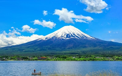
Mt. Fuji in COOL JAPAN VIDEOS Photo Contests: 10 Photos Showcasing the Different Views of Mt. Fuji
Nature Travel- 3.52K views
COOL JAPAN VIDEOS is always holding photo contests. This time, we have selected photos that capture the majestic Mt. Fuji, located on the border of Yamanashi and Shizuoka prefectures. We'll also introduce the locations where the photos were taken, so be sure to enjoy each one so you don't miss out on some useful information! COOL JAPAN VIDEOS is a social, video curation site that introduces the charms of Japan to people around the world who are interested in Japan. Our photo contests allow you to participate and even win with photos taken via your smartphone! Stick around to learn more! ■Table of Contents - Mt. Fuji in Past Photo Contests The Aftermath of the Hoei Eruption Swans at Lake Yamanaka The Tea Fields of Obuchi Sasaba Fujiyoshida Oshino Hakkai Aka-Fuji The Daikanzan Observatory Kawaguchi Asama Shrine The Fumotoppara Campground The Takabocchi Highlands - Features of COOL JAPAN VIDEOS Photo Contests - Current Photo Contest - Summary of Mt. Fuji in COOL JAPAN VIDEOS Photo Contests Mt. Fuji in Past Photo Contests Let's take a look at some of the wonderful photos taken of Mt. Fuji from the many fantastic works that convey the beauty of Japan. COOLJAPANVIDEOS Photographer: 01ktk15 Location: Mizugatsuka Park (Susono, Shizuoka) A Place Where You Can Photograph the Aftermath of the Hoei Eruption Fuji's flanks were blown away by the Hoei Eruption in 1707 during the Edo period (1603-1868 AD), forming the bowl-shaped Hoei Crater. At Mizugatsuka Park, you can photograph the crater in its entirety as it changes from season to season. The crater is located along the Fuji Skyline, near the second station of Mt. Fuji at an elevation of 1,450 meters. You can capture powerful compositions that include the beauty of Mt. Fuji, while reminding you that it's still a mighty volcano. An Article About Mt. Fuji Video article 4:21 Fuji - Japan's Largest Tourist Attraction and the Pride of the Country. Its Mysterious Beauty Fascinates All Who See It YouTube COOLJAPANVIDEOS Photographer: タケタロ Location: Lake Yamanaka (Minamitsuru, Yamanashi) When to See Swans at Lake Yamanaka Swans can usually be seen at Lake Yamanaka around December and fly back north around March or April. Some species of swans are don't migrate, and instead lay eggs and raise their young in the grassy knolls along the shores of Lake Yamanaka in spring. Mt. Fuji is located to the southwest of Lake Yamanaka. If you're looking to capture the majestic Mt. Fuji with beautiful swans and snowy winter scenery in one photograph, the northern shore of Lake Yamanaka is your best bet. A Sightseeing Article About Lake Yamanaka Video article 1:53 Go Sightseeing at Lake Yamanaka, Nestled at the Foot of the Sacred Mt. Fuji! The Yamanakako Area, Surrounded by Nature, Is One of the Top Sightseeing Destinations in Japan! YouTube COOLJAPANVIDEOS Photographer: phantastic420 Location: Obuchi Sasaba (Fuji, Shizuoka) The Tea Fields of Obuchi Sasaba Obuchi Sasaba in the Obuchi district of Fuji City is a photo spot where you can capture Mt. Fuji over vast tea fields with no power lines or buildings to obstruct your view. Many photographers come to capture the verdant tea fields with the towering Mt. Fuji in the backdrop. Located about 10 minutes by car from the Tomei-Fuji and Shin-Tomei Shin-Fuji interchanges, the best time to visit is when the tea leaves are sprouting, particularly from mid-April to mid-May. An Article About Tea Fields and Mt. Fuji Video article 2:09 Obuchi Sasaba - Beautiful Tea Fields and Mt. Fuji in Shizuoka, Japan! YouTube COOLJAPANVIDEOS Photographer: Yuto Yamada Location: Fujiyoshida, Yamanashi Fujiyoshida, a Town With an Amazing View of Mt. Fuji Fujiyoshida, in Yamanashi prefecture, is the closest town to Mt. Fuji and features spectacular views of the mountain. In particular, at Arakurayama Sengen Park, it's possible to capture Mt. Fuji, cherry blossoms, and the 5-story Chureito Pagoda in one frame. Fuji, cherry blossoms, and the five-story pagoda in the frame. On top of the cherry blossoms in spring, visitors can enjoy the depth and splendor of each season here, including the fresh greenery of summer, the autumn foliage in fall, and the splendid snow landscapes in winter, all of which are sure to delight. An Article on Kitaguchi Hongu Fuji Sengen Shrine in Fujiyoshida Video article 3:16 Kitaguchi Hongu Fuji Sengen Shrine - Learn About One of Japan's Most Famous Power Spots, Located in Yamanashi Prefecture, Where the Sacred Mt. Fuji Resides, and Information About Popular Amulets and Shuin Stamps for Tourists! YouTube COOLJAPANVIDEOS Photographer: Nguyen Vu Location: Oshino Hakkai (Minamitsuru, Yamanashi) The Beautiful Oshino Hakkai Oshino Hakkai is a sacred spring located at the foot of the natural monument, Mt. Fuji, and is considered a power spot. The pure spring water from Mt. Fuji, a sacred mountain, is said to hold sacred power. This photo conveys the atmosphere and purity of Oshino Hakkai. If you visit Oshino Hakkai, be sure to take a picture, as it will be treasured for a lifetime. An Article on Oshino Hakkai Video article 4:22 Oshino Hakkai - Breathtaking Scenery at the Foot of Mt. Fuji! YouTube COOLJAPANVIDEOS Photographer: Phúc Jindo Location: Oshino, Yamanashi Photographing the Auspicious Aka-Fuji Aka-Fuji (Red Fuji) has long been a symbol of good luck for warding off evil spirits and bringing prosperity to business. It is a sight that photographers all over Japan hope to see. However, the conditions for photographing Aka-Fuji are very specific. Aka-Fuji can only be seen from the eastern side of the mountain from late summer to early autumn, just after sunrise, and on a clear day after rain. If you're a photographer and up for a challenge, we definitely recommend trying to capture this beautiful sight. An Article About Narusawa, Yamanashi, Located at the Foot of Mt. Fuji Video article 2:40 Introducing “Narusawa, Yamanashi,” Home to the Tallest Mountain in Japan. Behold the Jaw Droppingly Beautiful Scenery of Mt. Fuji. YouTube COOLJAPANVIDEOS Photographer: 01ktk15 Location: Daikanzan Observatory (Ashigarashita, Kanagawa) A Breathtaking View From the Daikanzan Observatory The name "Daikanzan" (lit. "Large Viewing Mountain") comes from the artist Yokoyama Taikan, who liked to paint Mt. Fuji from the Sky Lounge at the summit of the 1,011-meter-tall mountain. The spectacular view makes for an excellent photo and will take up a special place in your heart. It's especially popular in winter when the air is crisp and clear. Mt. Fuji and Lake Ashinoko covered with snow is guaranteed to result in a dignified work of art. An Article on the Best Places to View Mt. Fuji Video article 7:32 The Graceful Sight of the World-Famous Mount Fuji Can Be Enjoyed From All Over Japan. This Article Will Help You Find a Spot to View Mt. Fuji That’s Just Right for You! YouTube COOLJAPANVIDEOS Photographer: Phúc Jindo Location: Kawaguchi Asama Shrine (Minamitsuru, Yamanashi) Kawaguchi Asama Shrine – A Torii in the Sky Kawaguchi Asama Shrine was built to worship Mt. Fuji's god, Sengen-O-no-kami, in order to quell a major volcanic eruption of Mt. Fuji. The torii gate is located approximately 30 minutes on foot from the shrine grounds, and the view of Mt. Fuji is beautiful beyond words. It's also called the "Torii in the Sky," and is a recommended spot known for being especially picturesque. An Article on Kawaguchi Chigo no Mai at Kawaguchi Asama Shrine Video article 3:15 Kawaguchi Sengen Shrine, Now a World Cultural Heritage Site! A Look at the Beautiful Traditional Dance, "Kawaguchi Chigo no Mai"! YouTube COOLJAPANVIDEOS Photographer: mioka Location: Fumotoppara Campground (Fujinomiya, Shizuoka) Mt Fuji From the Fumotoppara Campground The best part about the Fumotoppara Campground is that you can see Mt. Fuji in its entirety from the summit to the base. It is truly a picturesque view. Located in Fujinomiya, the Asagiri Plateau, known for its foggy appearance, is also in the vicinity. At the Fumotoppara Campground, a place loved by campers, you can experience the outdoors with a magnificent view of Mt. Fuji. An Article on the Yamanakako Fuji Snow Festival Video article 3:10 Enjoy the Beauty of Mt. Fuji to the Fullest at the Yamanakako Fuji Snow Festival! YouTube COOLJAPANVIDEOS Photographer: HKP Location: Takabocchi Highlands (Shiojiri, Nagano) Mt. Fuji From the Takabocchi Highlands From the summit of the mountain, which offers a 360-degree view of the Takabocchi Highlands, Lake Suwa, the lights of the city by the lake, and the sea of clouds all add to the main attraction of Mt. Fuji. The area is especially spectacular from autumn, when the air is clear and the night views are spectacular, to the time when the access road is closed for the winter. It's hard to take a better picture than Mt. Fuji and a sea of clouds, early in the morning, before the sun rises and when the sky is tinted orange. An Article on the Mt. Fuji World Heritage Centre Video article 2:32 The Mt. Fuji World Heritage Centre Is a New-Age Museum That Fuses Digital and Analog! The Museum, Located in Fujikawaguchiko, Yamanashi, Is Full of Facilities That Convey the Beauty of the World Heritage Site Mt. Fuji! YouTube Features of COOL JAPAN VIDEOS Photo Contests COOL JAPAN VIDEOS is a social, video curation site that showcases the charms of Japan to people around the world who are interested in Japan. Click here for more information about COOLJAPANVIDEOS Anyone can enter COOL JAPAN VIDEOS' photo contests! Below are some of the features of our contests. ・On top of single-lens reflex cameras and digital cameras, photos taken with smartphones and other devices can also be submitted. ・Each person can submit as many photos as they like during the contest period. ・Editing of images, such as cropping and color changes, is also allowed! Here you can find all of the past photo contest winners in one place. You can also see the prizes for each contest, as well as the locations where the photos were taken and the judges' critiques. Click here to see past photo contest winners Text only Photo Contest Results - COOL JAPAN VIDEOS Winning Photos - Discover the Charms of Japan! Current Photo Contest The following is information about the current photo contest. [Ongoing From November 2023] The 20th COOL JAPAN VIDEOS Photo Contest Theme: The Beauty of Japan Submission period: November 1, 2023 0:00 AM – December 31 2023 11:59 PM(JST) Prizes: ■Grand Prize: 30,000 yen Amazon gift card (1 Winner) ■Honorable Mentions: 10,000 yen Amazon gift card (5 Winners) The Beauty of Japan Photo Contest Landscape Photography Summary Did you enjoy these landscape photos from past photo contest entries? Some of these landscapes can only be seen in specific conditions. Japan is full of rich nature, historical locations, and seasonal events! Share your photos with the world and help showcase the beauty of Japan through COOL JAPAN VIDEOS! Related Articles Text only Children of COOL JAPAN VIDEOS Photo Contests: 10 Heartwarming Photos That Will Put a Smile on Your Face! Text only Autumn in COOL JAPAN VIDEOS Photo Contests: 10 Beautiful Photos of Autumn in Japan Text only Mt. Fuji in COOL JAPAN VIDEOS Photo Contests: 10 Photos Showcasing the Different Views of Mt. Fuji Text only Hokkaido in COOL JAPAN VIDEOS Photo Contests: From Popular Sightseeing Spots to Exotic Animals, Discover the Beauty of Japan's Northernmost Prefecture! Text only Tohoku in COOL JAPAN VIDEOS Photo Contests: Hot Springs, Festivals, Snowscapes, and More – 10 Beautiful Photos of Japan's Tohoku Region! Text only Kyoto in COOL JAPAN VIDEOS Photo Contests: 10 Beautiful Photos of Kyoto, the Ancient Capital of Japan, and Its Most Popular Tourist Attractions! Text only Tokyo in COOL JAPAN VIDEOS Photo Contests: 10 Photos Featuring the Charms of Tokyo, the Capital of Japan + Popular Tourist Attractions! Text only Winter in COOL JAPAN VIDEOS Photo Contests: 10 Photos Capturing the Beauty of Winter in Japan. Snowy Landscapes, Glittering Illuminations + More! Text only Kansai in COOL JAPAN VIDEOS Photo Contests: 10 Spectacular Views of Japan's Kansai Region. From Night Views to Traditional Events, Discover the Best Photo Spots in Kansai! Text only Cherry Blossoms in COOL JAPAN VIDEOS Photo Contests: 10 Amazing Views of Cherry Blossoms, from Castles and Temples to Rows of Cherry Blossom! .separation_line { border-width: 0 0 8px; border-style: solid; border-image: url('data:image/svg+xml,') 0 0 100% repeat; width: 216px; margin:auto; margin-bottom: 50px; } -
 Video article 18:17
12 Popular Spots To Enjoy Autumn Leaves in Tokyo! The Imperial Palace, Shinjuku Gyoen, Hibiya Park, and More! Tons of Places To Enjoy Autumn Leaves in the Heart of Tokyo!
Nature- 216 plays
- YouTube
Introducing Recommend Spots To View Autumn Leaves in Tokyo, via Video! This video, titled "4K Top12 Tokyo Autumn Leaves Fall Foliage Trip Sightseeing, Travel, Inui-dori, Shinjuku Gyoen, Ueno Park, Jingu Gaien, Otaguro Park, Hibiya Park, Rikugien Gardens, Showa Kinen Park" (4K 東京の紅葉TOP12 Tokyo autumn leaves Fall Foliage Trip 観光 旅行 乾通り 新宿御苑 上野公園 神宮外苑 大田黒公園 日比谷公園 六義園 昭和記念公園), was released by Discover Nippon. This video introduces 12 popular places for viewing autumn leaves in Tokyo in Japan's Kanto region. From mid-November to early December, when autumn is in full swing, the deciduous trees in Tokyo are bursting with color. Enjoying the scenery of the leaves turning to brilliant shades of red and yellow is one of Japan's favorite autumn pastimes. This article will go over sightseeing information for 12 different destinations to view the autumn foliage in Tokyo. In the video, each location is seen via an aerial view using Google Earth, followed by an introduction to the scenery of the autumn leaves. You can also see the autumn foliage lit up in some parts of the video and the sheer beauty of it will take your breath away. 12 Locations to View the Autumn Foliage in Tokyo Photo:Koishikawa Korakuen Garden, Tokyo, in autumn with beautiful autumn foliage ◆Popular Locations to View the Autumn Foliage in Tokyo - Location #1 [The Imperial Palace & Inui Street (Inui-dori)] (Video 0:27-) The first locations to be introduced are The Imperial Palace & Inui Street. The Imperial Palace is a vast, lush green area in Tokyo where official government events are held. In order to enjoy the autumn foliage at the Imperial Palace, Inui Street is opened to the public during the fall. No reservations are required to enter and it is free of charge. There's a grove of various trees in the Imperial Palace where you can enjoy the autumn colors of various oak trees, such as konara and kunugi oaks. Access is a 5-minute walk from Tokyo Metro Otemachi Station to Otemon Gate, or approximately 15-minutes from Tokyo Station on foot. ◆Popular Locations to View the Autumn Foliage in Tokyo - Location #2 [Koishikawa Korakuen Gardens] (Video 1:37-) Koishikawa Korakuen Garden is designated as a special historic site and a special place of scenic beauty by the Japanese government. The red maple trees are beautiful and you can enjoy viewing the beautiful scenery reflected on the water's surface. Adjacent to Tokyo Dome, Koishikawa Korakuen Garden is a 3-minute walk from Iidabashi Station off the Toei Subway Oedo Line and an 8-minute walk from the west exit of JR Suidobashi Station. The entrance fee is 300 yen for adults. ◆Popular Locations to View the Autumn Foliage in Tokyo - Location #3 [Tonogayato Garden] (Video 2:42-) At Tonogayato Garden, visitors can enjoy the garden of maple trees from the former tea house "Koyo-tei." Tonogayato Garden is a two-minute walk from Kokubunji Station, and the admission fee is 150 yen for adults. ◆Popular Locations to View the Autumn Foliage in Tokyo - Location #4 [Shinjuku Gyoen] (Video 3:33-) Shinjuku Gyoen is a Japanese garden located in Shinjuku, a city of high-rise buildings. Shinjuku Gyoen is a five-minute walk from Shinjuku-Gyoenmae Station off the Tokyo Metro Marunouchi Line. The entrance fee is 500 yen for adults. ◆Popular Locations to View the Autumn Foliage in Tokyo - Location #5 [Gyoko-dori, Marunouchi] (Video 4:57-) Marunouchi Gyoko-dori connects the Marunouchi Central Exit of Tokyo Station to Uchibori-dori in front of the Imperial Palace. The official name of the road is "Tokyo Metropolitan Road No. 404, Imperial Palace Tokyo Station Line" (東京都道404号皇居前東京停車場線). Photo:Autumn leaves in Hibiya Park, Tokyo ◆Popular Locations to View the Autumn Foliage in Tokyo - Location #6 [Hibiya Park] (Video 5:46-) Hibiya Park, opened in 1903, is Japan's first "modern Western-style park.” At Hibiya Park, visitors can enjoy the beautiful rows of maple and ginkgo trees, and admission is free. Hibiya Park is a two-minute walk from Hibiya Station. ◆Popular Locations to View the Autumn Foliage in Tokyo - Location #7 [Ueno Onshi Park] (Video 6:47-) On top of hosting museums and a zoo, Ueno Onshi Park is also a great place for viewing the beautiful autumn foliage. Ueno Onshi Park is a two-minute walk from Ueno Station and the bright yellow ginkgo trees are especially breathtaking. ◆Popular Locations to View the Autumn Foliage in Tokyo - Location #8 [Showa Kinen Park] (Video 8:37-) Showa Kinen Park, a national park, is a short walk from Nishi Tachikawa Station off the JR Ome Line, and is a popular spot where you can enjoy a tunnel of ginkgo trees. The entrance fee is 450 yen for adults. ◆Popular Locations to View the Autumn Foliage in Tokyo - Location #9 [Ginkgo Trees at The University of Tokyo's Hongo Campus] (Video 9:59-) The row of gingko trees that stretch from the front of the Yasuda Auditorium to the main gate are a sight to behold. An approximately 1-minute walk from Todai-mae Station off the Tokyo Metro Namboku Line. ◆Popular Locations to View the Autumn Foliage in Tokyo - Location #10 [Ginkgo Trees at Meiji Jingu Gaien] (Video 11:22-) Meiji Jingu Gaien’s Ginkgo Avenue is a popular spot for viewing the autumn foliage, with a total of 146 ginkgo trees. There are also stylish open cafes around the area, which are lit up at night. Meiji Jingu Gaien’s Ginkgo Avenue is a 10-minute walk from Shinanomachi Station off the JR Sobu Line. ◆Popular Locations to View the Autumn Foliage in Tokyo - Location #11 [Otaguro Park] (Video 15:10-) Otaguro Park (Ootaguro Park) was built on the site of the former residence of Mr. Otaguro, a famous music critic. You can enjoy zelkova and ginkgo trees, and the park is lit up beautifully at night. Otaguro Park is a 10-minute walk from the south exit of Ogikubo Station. ◆Popular Locations to View the Autumn Foliage in Tokyo - Location #12 [Rikugien Garden] (Video 16:50-) Rikugien is a garden that truly represents the Edo Period (1603-1868 A.D.), and is decorated with maples and ginkgo trees in a garden with mountains and ponds, and is also illuminated. Rikugien Garden is a 7-minute walk from Komagome Station off the JR Yamanote Line, and the general admission fee is 300 yen. Summary of Popular Locations to View the Autumn Foliage in Tokyo Photo:Autumn leaves at Tonogayato Garden, Tokyo This video, titled “4K Top12 Tokyo Autumn Leaves Fall Foliage Trip Sightseeing, Travel, Inui Street, Shinjuku Gyoen, Ueno Park, Jingu Gaien, Otaguro Park, Hibiya Park, Rikugien Gardens, Showa Kinen Park,” introduces 12 popular locations to view the autumn foliage in Tokyo. If you're looking for places to enjoy the beautiful autumn foliage of Tokyo this season, be sure to check out the video to get some ideas on where to visit! -
Video article 24:24
Rock Climbing on Mt. Oku-Hotaka! The Breathtaking View From the Peak of the Mountain in Nagano and Gifu Prefectures Will Change How You View the World!
Nature- 391 plays
- YouTube
Introducing a round-trip mountain climbing video from Okuhotaka to Uma no Uma no Uta, spanning Nagano and Gifu Prefectures. This video, titled "Mt. Oku-Hotaka to Gendarmes|Route Change After a Rockslide|Video of a Detailed Round Trip of Uma no Se" (奥穂高からジャンダルム 滑落みて馬の背ピストンへ変更 馬の背詳細往復動画), was uploaded by "Biryu Jr." Mt. Oku-Hotaka Photo:The Hotaka mountain range from Mt. Norikura Mt. Oku-Hotaka is the main mountain of the Hotaka Mountain Range, which straddles Nagano and Gifu prefectures in the Hida Mountain Range of Chubu-Sangaku National Park in the southern part of Japan's Northern Alps. At 3,190 meters above sea level, it is the highest peak in the Northern Alps and the third highest in Japan after Mt. Fuji and Mt. Kita. Mt. Oku-Hotaka (奥穂高岳), Mt. Karasawa (涸沢岳), Kita-Hotaka (北穂高岳), Mae-Hotaka (前穂高岳), Nishi-Hotaka (西穂高岳), and Mt. Myojin (明神岳), are collectively referred to as Mt. Hotaka. It is said that the origin of the mountain's name comes from a legend that a god named Hotakami-no-Mikoto descended to the summit of Mt. Oku-Hotaka. Even today, the mountain is revered as a sacred mountain by local people, who visit and climb it to pray. The first person to summit Mt. Oku-Hotaka was surveyor Gunji Abe in 1906. With its challenging routes, powerful rocky ridges, and panoramic views from the ridge, Mt. Hotaka continues to attract many climbers to this day. The Geological Features of Mt. Oku-Hotaka Here, we'll take a look at the geological features of Mt. Oku-Hotaka ・Volcanic Terrain Mt. Hotaka, including Mt. Oku-Hotaka, is formed mainly of dacitic ignimbrite called "Hotaka andesite." This rock was formed by pyroclastic flows during an eruption approximately 1.75 million years ago, and was uplifted 2,000m over a period of 1 million years after a large-scale eruption. ・Glacial Landforms Many glacial landforms have been observed on Mount Hotaka. Glacial landforms are landforms created by glaciers that have accumulated soil, sand, rocks, etc., while carving away the land below. Mt. Oku-Hotaka – Uma no Se Photo:Uma no Se on Mt. Oku-Hotaka Mt. Okuhotaka, a famous mountain climbing spot, has a narrow ridge called "Uma no Se" (horse's back), which is steep and features cliffs on both sides. Because of how steep it is, it's also a dangerous place where falling accidents occur frequently. The slopes, which look like a combination of rubble, require extreme caution in order to prevent accidents. In the video, you can see how they decide not go to Gendarme (a rocky summit between Mt. Oku-Hotaka and Mt. Nishi-Hotaka), and instead decide to descend via Uma no Se. It's as realistic as if you were there yourself. The sound of the wind, the hands gripping the rocks, the shadows of climbers moving toward the spectacular views... the power of these scenes draws you in. [Video] 5:44 - Advancing Along Uma no Se Mt. Oku-Hotaka – Routes and Difficulties Here are the routes of Mt. Oku-Hotaka according to difficulty level: ・Kamikochi Course (上高地コース) - The recommended route for beginners Starting from Kamikochi Bus Center, the most common route is [Myojin (明神) - Tokusawa (徳沢) - Yoko (横尾) - Hontanibashi (本谷橋) - Karasawa (涸沢) - Mt. Hotaka Hut (穂高岳山荘, Hotakadake Sanso), Mt. Oku-Hotaka]. Your itinerary should be arranged according to your physical fitness. It is common to stay overnight during the climb. ・Kenkyakusha-Muke Course (健脚者向けコース) The rough route is [Shin Hotaka Onsen (新穂高温泉) - Shirade Hut Ruins (白出小屋跡) - Mt. Hotaka Hut (穂高岳山荘), Mt. Oku-Hotaka]. The trailhead is at Shin Hotaka Onsen. Since there are some points on the ascent where it's easy to make a mistake on the route, it's recommended that you be accompanied by an experienced climber. Furthermore, since route conditions change according to lingering snowfall, it's necessary to check trail conditions ahead of time. ・Advanced Climbing Course (熟練・上級者向けコース) The rough route is [Kamikochi Bus Terminal (上高地バスターミナル) - Yoko (横尾) - Yarisawa Lodge (槍沢ロッジ) - Kakusei Hutte (殺生ヒュッテ) - Yarigatake Hut (槍ヶ岳山荘) - Minamidake Hut (南岳小屋) - Kitahotaka Hut - Mt. Kitahotaka Hut (北穂高小屋) - Karasawa Hut (涸沢岳) - Mt. Hotaka Hut (穂高岳山荘)]. The ridge course from Yarigatake continues through rocky terrain with considerable height differences. Normally, three nights are required for this route, and extreme caution is needed as there are many steep sections. Summary of Mt. Oku-Hotaka Photo:Mt. Oku-Hotaka In this article. we introduced one of the three tallest peaks in Japan, Mt. Oku-Hotaka, and Uma no Se. Although there are dangers, such as slips and falling rocks, Mt. Oku-Hotaka is a thrilling mountaineering experience that features spectacular views of nature that attracts many climbers. Although the climb is not without its dangers, the view from the summit and the thrill of climbing over Uma no Se is said to be exceptional. If you wish to take on this challenge, please do your research and go fully prepared. That being said, if you're just here to enjoy some of the views, hopefully the video is enough for you. 【TripAdvisor】Mt. Oku-Hotaka https://www.tripadvisor.com/Attraction_Review-g298102-d7242442-Reviews-Mt_Okuhotaka-Chubu.html -
Text only
Autumn in COOL JAPAN VIDEOS Photo Contests: 10 Beautiful Photos of Autumn in Japan
Nature Travel- 5.01K views
COOL JAPAN VIDEOS is always holding photo contests. This time, we have selected photos that capture a glimpse of autumn from among those submitted to our past photo contests. Autumn in Japan means autumn leaves, seasonal foods, outdoor activities, sports, art, travel, and so much more. Some of the photographs introduced in this article can only be taken under very specific conditions and with the right timing. We hope you take the time to enjoy them. COOL JAPAN VIDEOS is a social, video curation site that introduces the charms of Japan to people around the world who are interested in Japan. Our photo contests allow you to participate and even win with photos taken via your smartphone! Stick around to learn more! ■Table of Contents - Autumn in Past Photo Contests The Maple Corridor of Lake Kawaguchi Ryuzu Falls, Nikko Daisho-in Temple Bales of Straw After a Rice Harvest Akatombo (Red Dragonflies) Hitachi Seaside Park Takeda Castle Ruins, the Castle in the Sky Salmon Spawning in Hokkaido Spider Lilies - Features of COOL JAPAN VIDEOS Photo Contests - Current Photo Contest - Summary of Autumn in COOL JAPAN VIDEOS Photo Contests Autumn in Past Photo Contests Past COOL JAPAN VIDEOS photo contests were filled with many wonderful works that convey the charms of Japan! Let's take a look at some of the wonderful photos taken in autumn. We'll also include the locations where the photos were taken and related articles for reference. COOLJAPANVIDEOS Photographer: Phúc Jindo Location: Lake Kawaguchiko (Minamitsuru, Yamanashi) The Maple Corridor of Lake Kawaguchi, a Photogenic Spot in Autumn Mt. Fuji and Lake Kawaguchi are extremely popular among photographers. 400-500 maples can be seen along the shores of Lake Kawaguchi, making this area one of the best places for photographing the beautifully colored leaves that cover the road and create a tunnel of autumn leaves. The Fuji Kawaguchiko Autumn Leaves Festival is held every year from late October to mid-November, and the illuminated corridor offers a fantastic view of autumn leaves and Mt. Fuji. An Article on Mt. Fuji Video article 4:21 Fuji - Japan's Largest Tourist Attraction and the Pride of the Country. Its Mysterious Beauty Fascinates All Who See It YouTube COOLJAPANVIDEOS Photographer: YOU Location: Ryuzu Falls (Nikko, Tochigi) The Charms of Ryuzu Falls, Nikko Ryuzu Falls is one of the three most famous waterfalls in Nikko. The name Ryuzu (竜頭 Ryuzu, lit "Dragon's Head") comes from its resemblance to a dragon's head, which is divided into two halves by large rocks. Starting in late September, visitors to the falls can enjoy beautiful autumn leaves, and from May to June, the vibrant magenta of the azaleas can be observed. An Article on Sightseeing in Nikko Video article 10:36 A Look at the Beautiful Autumnal Scenery Created by Mother Nature! Enjoy Autumn in Japan With Kegon Falls and the Autumn Foliage of Lake Chuzenji, Two of Nikko, Tochigi's Most Famous Scenic Spots! YouTube COOLJAPANVIDEOS Photographer: なもち@広島おでかけちゃんねる Location: Daisho-in Temple (Hatsukaichi, Hiroshima) Highlights of Daisho-in Temple Daisho-in Temple is the oldest and most prestigious temple in Miyajima, Hiroshima, and was founded by Kobo Daishi (Kukai), the Japanese Buddhist monk that founded the esoteric Shingon school of Buddhism. The temple is said to have been visited by great figures, such as Toyotomi Hideyoshi and Ito Hirobumi, successive members of the imperial family, and in 2006, the 14th Dalai Lama. The temple is home to many attractions, including the Five Hundred Rakan (Arhats), each wearing a hat and bearing a different expression; Henjokutsu Cave, a beautiful cave with 88 depictions of Buddha and lanterns covering the ceiling; and many cute Jizo statues. Daisho-in Temple, a power spot and one of Miyajima's most popular tourist attractions, is located just 5-minutes from Itsukushima Shrine. An Article on Sightseeing in Hiroshima Video article 8:04 Itsukushima Shrine Is a Popular Spot in Hiroshima You Don't Want to Miss! The Vermilion-Lacquered Torii Gate Over the Sea Is a Fantastic Sight, Chosen as One of the Three Most Beautiful Sights of Japan! YouTube COOLJAPANVIDEOS Photographer: T.S.P Bales of Straw After a Rice Harvest Terraced rice fields create a variety of landscapes, and the verdant rice paddies seem to extend to the horizon. The picturesque scenery of rice paddies, with their uniquely Japanese atmosphere, evokes a sense of familiarity. Autumn is associated with autumn leaves, but bales of straw, which can be seen only for a short period of time after the rice harvest, are one of the signature landscapes of Hokkaido. These bales of straw are used as cattle feed during the harsh winters of northern Japan. An Article on Sightseeing in Hyogo Video article 4:00 The Beautiful Rice Paddies of Japan in 4K. Golden Ears of Rice Painted on the Horizon Bring Peace to the People of Japan YouTube COOLJAPANVIDEOS Photographer: Lily0321 Akatombo (Red Dragonflies) In Japan, many people know that autumn has arrived when they see red dragonflies flying about. In Japanese, "Akatombo" (red dragonfly) is a generic name for dragonflies belonging to the family of dragonflies in the genus "Akane." There are 21 species of dragonflies belonging to the Akane genus in Japan. The wandering gliders (pantala flavescens) that fly in swarms in autumn are also sometimes called akatombo. An Article on the Oniyanma, the Largest Dragonfly in Japan Video article 1:30 The Oniyanma: Amazing Footage of Japan's Largest Dragonfly! See It Molting and Laying Eggs in Nature... YouTube COOLJAPANVIDEOS Photographer: k Yoji Location: Hitachi Seaside Park (Hitachinaka, Ibaraki) The Charms of Hitachi Seaside Park Hitachi Seaside Park is a place where visitors can enjoy seasonal flowers and is home to the Kochia Carnival from early to late October. Miharashi Hill is covered with about 32,000 bright red kochia (summer cypress), making it a photogenic spot popular among instagrammers. In spring, daffodils, tulips, and nemophila (baby blue eyes) are at their best, and in summer, the green kochia are lit up at night with colorful LED lights, creating a different atmosphere from that of the daytime. An Article on Sightseeing in Ibaraki Video article 5:05 Ibaraki Prefecture: A Tourist Attraction With Everything From Nature to the Latest in World-Class Space Technology. An In-Depth Look at Ibaraki's Cuisine and History! YouTube COOLJAPANVIDEOS Photographer: Nguyen Vu Location: The Takeda Castle Ruins: The Castle in the Sky (Asago, Hyogo) The Charms of the Takeda Castle Ruins, the Castle in the Sky The Takeda Castle Ruins, dubbed the Machu Picchu of Japan, is a site built entirely of stone walls on the 353.7-meter-tall summit of Mt. Kojo. The sight of the castle floating in the sea of clouds is truly fantastic, and the title of "Castle in the Sky" is no exaggeration. Although many people are determined to see this spectacular view, the sea of clouds only presents itself when the weather and other conditions are just right. The sea of clouds most often occurs between September and October, from dawn to around 8:00 a.m. Fog tends to form when there is a temperature difference of more than 10°C between day and night, when it is sunny during the day and cool at night, and when the wind is light. An Article on the Takeda Castle Ruins, the Castle in the Sky Video article 2:29 Behold the Mesmerizing Scenery of Takeda Castle, Hidden in a Sea of Clouds in Asago, Hyogo! Called the "Machu Picchu of Japan" and "Castle in the Sky," Takeda Castle Attracts Thousands of Tourists From All Over the World! YouTube COOLJAPANVIDEOS Photographer: 古谷久樹 Location: Hokkaido Salmon Spawning in Hokkaido in Autumn and Winter Salmon swimming upriver is a typical view during autumn in Hokkaido. In autumn, many salmon head upstream to spawn. The sight of the salmon, which have spent around four years growing up in the Pacific Ocean, risking their lives to return home while their bodies are battered by rocks and other obstacles, shows the beauty of life and evokes a feeling of romance. They can be seen in Hokkaido's Toyohira River, Kotonihassamu River, Uyoro River, and Hamamasu River among others. An Article on Hokkaido's Ezo Brown Bears and Salmon Video article 7:40 Ezo Brown Bears Catching Lunch in the Outdoors of Hokkaido! See the 2-Meter-Tall Bears Snatching Fish From a River Right Before Your Eyes! YouTube COOLJAPANVIDEOS Photographer: Haruna Location: Kuhonji Temple (Gosho, Nara) The Charms of Spider Lilies In late September, Kuhonji Temple is so popular that early in the morning, many people scramble to find a spot to photograph the bright red spider lilies and the morning sunrise. In Japan, spider lilies are called higanbana (lit. "Higan Flowers") because they bloom around the time of Higan, a Buddhist holiday exclusively observed in Japan, but they are also called "manjushage," which in Sanskrit means "The flower that blooms in the heavens." In the language of flowers, it has the meaning of passion, and its short flowering period of only about a week gives it a mysterious, ephemeral charm. An Article on the Red Spider Lily Festival of Hidaka, Saitama Video article 3:49 Discover More Than 5 Million Spider Lilies at the "Red Spider Lily Festival" at Kinchakuda in Hidaka, Saitama, One of the Largest Blooming Areas in Japan! The Sea of Red Will Take Your Breath Away YouTube Features of COOL JAPAN VIDEOS Photo Contests COOL JAPAN VIDEOS is a social, video curation site that showcases the charms of Japan to people around the world who are interested in Japan. Click here for more information about COOLJAPANVIDEOS Anyone can enter COOL JAPAN VIDEOS' photo contests! Below are some of the features of our contests. ・On top of single-lens reflex cameras and digital cameras, photos taken with smartphones and other devices can also be submitted. ・Each person can submit as many photos as they like during the contest period. ・Editing of images, such as cropping and color changes, is also allowed! Here you can find all of the past photo contest winners in one place. You can also see the prizes for each contest, as well as the locations where the photos were taken and the judges' critiques. Click here to see past photo contest winners Text only Photo Contest Results - COOL JAPAN VIDEOS Winning Photos - Discover the Charms of Japan! Current Photo Contest The following is information about the current photo contest. [Ongoing From March2024] The 22th COOL JAPAN VIDEOS Photo Contest Theme: Spring in Japan Submission period: March 1, 2024 12:00 AM – April 30, 2024 11:59 PM (JST) Prizes: ■Grand Prize: 30,000 yen Amazon gift card (1 Winner) ■Honorable Mentions: 10,000 yen Amazon gift card (5 Winners) Spring in Japan Photo Contest Landscape Photography Summary Did you enjoy these landscape photos from past photo contest entries? Some of these landscapes can only be seen in specific conditions. Japan is full of rich nature, historical locations, and seasonal events! Share your photos with the world and help showcase the beauty of Japan through COOL JAPAN VIDEOS! Related Articles Text only Children of COOL JAPAN VIDEOS Photo Contests: 10 Heartwarming Photos That Will Put a Smile on Your Face! Text only Autumn in COOL JAPAN VIDEOS Photo Contests: 10 Beautiful Photos of Autumn in Japan Text only Mt. Fuji in COOL JAPAN VIDEOS Photo Contests: 10 Photos Showcasing the Different Views of Mt. Fuji Text only Hokkaido in COOL JAPAN VIDEOS Photo Contests: From Popular Sightseeing Spots to Exotic Animals, Discover the Beauty of Japan's Northernmost Prefecture! Text only Tohoku in COOL JAPAN VIDEOS Photo Contests: Hot Springs, Festivals, Snowscapes, and More – 10 Beautiful Photos of Japan's Tohoku Region! Text only Kyoto in COOL JAPAN VIDEOS Photo Contests: 10 Beautiful Photos of Kyoto, the Ancient Capital of Japan, and Its Most Popular Tourist Attractions! Text only Tokyo in COOL JAPAN VIDEOS Photo Contests: 10 Photos Featuring the Charms of Tokyo, the Capital of Japan + Popular Tourist Attractions! Text only Winter in COOL JAPAN VIDEOS Photo Contests: 10 Photos Capturing the Beauty of Winter in Japan. Snowy Landscapes, Glittering Illuminations + More! Text only Kansai in COOL JAPAN VIDEOS Photo Contests: 10 Spectacular Views of Japan's Kansai Region. From Night Views to Traditional Events, Discover the Best Photo Spots in Kansai! Text only Cherry Blossoms in COOL JAPAN VIDEOS Photo Contests: 10 Amazing Views of Cherry Blossoms, from Castles and Temples to Rows of Cherry Blossom! .separation_line { border-width: 0 0 8px; border-style: solid; border-image: url('data:image/svg+xml,') 0 0 100% repeat; width: 216px; margin:auto; margin-bottom: 50px; } -
Video article 3:11
Experience the Beauty of Kikuchi Valley! Enjoy Clear Streams in the Nature of Kumamoto!
Nature Travel- 482 plays
- YouTube
Kikuchi Valley Video Introduction This video, titled "[4K UHD] Kikuchi Valley in Summer (Kikuchi, Kumamoto)" ([ 4K UHD ] 夏の菊池渓谷(熊本県菊池市)Kikuchi Valley in Summer), was uploaded by "AQUA Geo Graphic." Kikuchi Valley is a nature-rich valley located at the source of the Kikuchi River in Kumamoto Prefecture, and is widely known as a spot where visitors can enjoy its spectacular seasonal scenery. It is also a popular tourist spot for people of all ages, as visitors can enjoy various activities such as kayaking. Check out the beautiful images of Kikuchi Valley. Kikuchi Valley - One of the Most Beautiful Valleys in Kumamoto Photo:Aso-Kuju National Park Kikuchi Valley is known as a "forest of relaxation" stretching from Kikuchi to Aso in Kumamoto Prefecture. The Kikuchi Valley area is covered with primeval forests of firs and zelkova trees, and has been designated as a special recreation area in Aso-Kuju National Park. In addition, the Kikuchi Riverhead has been selected as one of the Top 100 Water Sources in Japan. Kikuchi Valley has many attractions, and waterfalls of various sizes. Reimei Falls around Ryugabuchi, Tengu Falls, and Yonjusanman Falls, selected as one of the Top 100 Waterfalls in Japan, are popular tourist attractions. In addition, Kikuchi Valley is so rich in nature that it has been selected as one of the Top 100 Forests for Forest Bathing and the Top 100 Nature Spots in Kumamoto because of the natural environment. Therefore, visitors are required to pay a maintenance fee to preserve the environment. From Cherry Blossoms to Autumn Leaves – Seasonal Highlights of Kikuchi Valley Photo:Autumn leaves in Kikuchi Valley Kikuchi Valley is known as a summer resort and is a place to cool off naturally. One of the highlights of the valley is that it is comfortable even in the hot Japanese summer, and visitors can enjoy a pleasant stroll in the great outdoors. There are two walking courses: a 1-km round-trip "Healing Course" and a 2-km round-trip "Negative Ion Enjoyment Course." The courses allow visitors to naturally detox their minds while enjoying the surrounding scenery. In spring, visitors can enjoy cherry blossoms at the Kikuchi Valley Rest Plaza, in fall, the autumn leaves begin to change color around the end of October, and in winter, the misty ice flowers bloom. Kikuchi Valley, with its beautiful and spectacular scenery throughout Japan's four seasons, offers plenty to see! The photogenic scenery is popular among photographers, instagrammers, and young people alike. Mizunoeki Pleasure Park - An Exciting Park for Families You might be worried that small children won't be able to have fun in a place with so much nature. For families, we recommend Mizunoeki Pleasure Park, located near the Kikuchi River flowing from Kikuchi Valley. Here, visitors can enjoy a variety of athletic activities, including BMX, and bouldering, and even go fishing in the fishing pond. After playing at Mizunoeki Pleasure Park, don't forget to take in the beautiful nature of Kikuchi Valley. Summary of Kikuchi Valley in Kumamoto, Japan Did you watch the video of Kikuchi Valley in summer, with its beautiful scenery and the soothing sound of flowing water? Camping and barbecues are prohibited in Kikuchi Valley in order to preserve the natural environment. Those who wish to enjoy playing in the river, camping, or barbecuing should use facilities such as Mizunoeki Pleasure Park or Mizunoeki Campground (水の駅キャンプ場). At Mizunoeki Pleasure Park, you can enjoy fishing for rainbow trout and salmon in the fishing pond, and you can even cook and eat them on-site. In the vicinity of Kikuchi Valley, there are facilities where you can enjoy a day trip to a hot spring, a visitor center where you can have lunch and refreshments, and two parking lots for sightseeing. Kikuchi Valley is close to Mt. Aso, and visitors can enjoy the spectacular view from the outer rim of the mountain. When sightseeing in Kumamoto, consider stopping by Kikuchi Valley, a place where you can experience Japan's great outdoors. In today's stressful society, it's important to get away from everyday life and detoxify your mind. And the natural scenery of Kikuchi Valley allows you to do just that. 【TripAdvisor】Kikuchi Valley https://www.tripadvisor.com/Attraction_Review-g1023370-d1238998-Reviews-Kikuchi_Gorge-Kikuchi_Kumamoto_Prefecture_Kyushu.html -
Video article 4:17
The Transparent Waters of Sunayama Beach on Miyakojima + Sightseeing Spots and Attractions on the Island in Okinawa
Nature Travel- 228 plays
- YouTube
Aerial Footage of Sunayama Beach on Miyakojima: Video Introduction This video, titled "[Drone Aerial Photography] Sunayama Beach, Miyakojima|Healing Drone Okinawa" (【ドローン空撮】宮古島 砂山ビーチ Healing Drone Okinawa), was uploaded by "Umi Note." It introduces the beautiful blue skies, sandy white beach, and clear waters of Miyakojima. Highlights of Sunayama Beach – Spectacular Views at Every Turn! Photo:Sunayama Beach, Miyakojima, Okinawa Sunayama Beach is located approximately 4 km from the center of Hirara, a city in Miyakojima, Okinawa Prefecture, in Japan's Kyushu Region. Despite its easy accessibility, the beach is surrounded by unexplored nature and beautiful, clear waters. The video shows the spectacular views of Sunayama Beach from beginning to end. The drone offers a unique view that you wouldn't normally be able to see, and the beach seen from the ocean side is so beautiful that it will leave you speechless. [Video] 0:35 - View From the Beach As the name of the beach suggests (砂山, Sunayama; lit. "Sand Mountain"), it's located over a small sand hill. From the parking lot near Sunayama Beach, there is a narrow path leading uphill. It's a bit difficult to climb while carrying luggage, but the view after reaching the top makes it totally worth the effort. You can't help but stop to take in the view. The Rock Arch at Sunayama Beach – A Popular Instagram Spot! The rock arch is a popular spot at Sunayama Beach. You can see the blue ocean through the rock and take photogenic pictures as well. It's also known as a sunset spot, where you can even see the sunset over the ocean inside the rock arch. We recommend relaxing on the beach and watching the sun set inside the rock arch. Things to Be Careful of at Sunayama Beach Photo:Sunayama Beach, Miyakojima, Okinawa The fact that Sunayama Beach is mostly unspoiled by human hands, means that it's full of natural beauty, but this also means there are a few precautions you should take when visiting the beach. The rock arch is currently closed off due to the danger of falling rocks and collapse. Visitors are advised to only go close to the rocks to take pictures. You can also swim at Sunayama Beach, but the waves are surprisingly tall and accidents have been known to occur. Be careful when snorkeling in areas where the water is even a little deep. Swim rings and life jackets may be necessary. There are also signs warning of sharks. We recommend staying in the shallow areas at Sunayama Beach, as there are no lifeguards on duty. Stay away from the beach when there is a surf advisory in effect. It's important to remember that you're dealing with nature, so please keep this in mind while enjoying your time on the beach. Restrooms and shower rooms are located in the parking lot. Toilets should be used before heading to the beach. The path to the beach is hilly and a bit long, so flip-flops or comfortable walking shoes are recommended. If you're with children, be sure to hold their hands when walking. There are no beach houses or restaurants on Sunayama Beach, so be sure to bring your own food or have lunch in the area. We recommend Sunayama Cafe in front of the beach. How to Get to Sunayama Beach Photo:An aerial view of Sunayama Beach, Miyakojima, Okinawa Compared to the main island of Okinawa, Miyakojima is relatively small. By car, it takes only 20 minutes to reach the beach from Miyako Airport and 10 minutes to reach from Hirara Port. Free parking is available as well. The video shows an aerial view of the entirety Miyakojima. [Video] 3:20 - Miyakojima From the Sky If you don't have a car, you can also rent a bicycle. If you rent a bicycle at Hotel Atoll Emerald Miyakojima, you can get to Sunayama Beach in about 15 minutes. Miyakojima Sightseeing Spots! In addition to Sunayama Beach, there are many other places on Miyakojima where you can enjoy the beautiful ocean, such as Yonaha Maehama Beach, Aragusuku Beach, and Shigira Beach. In addition to taking a dip in the ocean, simply admiring the scenery will leave you feeling content. Also, with the opening of the Miyako Shimojishima Airport Terminal in 2019, there are more fashionable cafes and restaurants. Miyakojima Tokyu Hotel & Resorts and Shigira Bayside Suite Alamanda are the most famous resort hotels, but there are also many nice hotels scattered throughout the area. Summary of Sunayama Beach, Miyakojima If you haven't already watched the video, be sure to check it out! You can enjoy Miyakojima's Sunayama Beach from the sky. Enjoy the sandy white beach, blue sky, and the crystal-clear waters of Miyakojima. If you're planning a trip to Okinawa, why not extend your trip a little further and visit Miyakojima? There are connecting flights to Miyakojima from Naha Airport and direct flights from Tokyo, Osaka, and Nagoya. The beautiful Sunayama Beach is waiting for you just beyond a sandy mountain. This is a place you don't want to miss! 【TripAdvisor】Sunayama Beach, Miyakojima https://www.tripadvisor.com/Attraction_Review-g680765-d1382554-Reviews-Sunayama_Beach-Miyakojima_Okinawa_Prefecture.html -
Video article 9:24
Beautifully Blooming Lilies at Fukaya Green Park! Explore the Wonderful Park in Saitama, Japan via Video
Nature Travel- 76 plays
- YouTube
Fukaya Green Park: Video Introduction This video, titled "Garden Species and Wild Species of Lilies, Both Are in Full Bloom at the Suburbs Tokyo," was uploaded by "Japan BackpackersXpress." This video introduces the colorful lilies blooming beautifully at Fukaya Green Park in summer, as well as wild lilies at the Sugaya-yakata Ruins and Sayama Inariyama Park. Be sure to give the video a watch to see the lovely lilies! More About Fukaya Green Park Fukaya Green Park, located in Fukaya, Saitama, opened in July 1996 as a project subsidized by the Ministry of Agriculture, Forestry and Fisheries. It is a complex facility with a swimming pool corner, flower and greenery corner, and a fitness corner. The Aqua Paradise Patio, one of the largest indoor amusement pools in Japan's northern Kanto region, is popular with children and adults alike. In addition, at the flower and greenery corner in Fukaya Green Park, visitors can experience the beautiful flowers of Japan's various seasons, with tulips in spring, lilies in summer, and cosmos all over the park in autumn. Various flower-related events are held at the park each month. For example, visitors can try their hand at flower arrangement using seasonal flowers through the seasonal flower lessons. In the past, visitors have also had the opportunity to try their hand at planting lily bulbs. The "Flower Concert" are held on the patio surrounded by flowers and greenery as well. It's possible to participate in the events by making reservations via the official website (Japanese only). The Best Time to See Garden Lilies at Fukaya Green Park Source :YouTube screenshot Fukaya City is one of the top producers of cut lilies. Fukaya Green Park, a must-see attraction for flower lovers, also grows Fukaya lilies, a local variety. The lilies in Fukaya Green Park are at their best from mid to late July. The video was shot on July 24, 2021, during the aforementioned period. Lily varieties include Cayenne, Hinault, Cesare, and Lexington, and they are planted by volunteers in mid-May. The lilies, which are at their best during the hot summer months, come in a variety of colors, including red, orange, yellow, pink, and white! About 20,000 lilies bloom in a variety of colors in the park, delighting visitors. The lilies blooming all over the area make it popular with Instagrammers and photographers. [Video] 3:13 - Colorful Lilies Blooming at Fukaya Green Park Seasonal Flowers at Fukaya Green Park Source :YouTube screenshot At Fukaya Green Park, you can see flowers blooming in every season. Here are some of the flowers you can expect to see. You can check the blooming status via a calendar on the official website. If there is a flower you're looking for, be sure to look it up before visiting the park. ・Flowers in Bloom in Spring Cherry blossoms, tulips, dogwood, roses ・Flowers in Bloom in Summer Crape myrtles, sunflowers, lilies ・Flowers in Bloom in Autumn Cosmos ・Flowers in Bloom in Winter Pansies, violas The Best Time to See Wild Lilies at Fukaya Green Park Photo:Lilies There are approximately 100 species of lilies in the world. In Japan, there are 15 species of true lilies, including mountain lilies, sasa-yuri, showy lilies, maiden lilies, and easter lilies. The sight of wild lilies blooming in the fields and mountains is so dignified and beautiful that you can't help but stop to admire them. In Saitama, Japan, various wild species of lilies can be found growing in the wild. The video shows wild lilies at Sayama Inariyama Park and the Sugaya-yakata Ruins. Here are some characteristics of the flowers that appear in the video. ・Mountain Lilies Mountain lilies are a native Japanese lily, distributed in Japan's Kinki region and northward. The plant is 1 to 1.5 meters tall and is characterized by its whitish petals. ・Tiger Lilies Tiger lilies grow wild, not only in Japan, but also in Guam and China. In Japan, it's distributed throughout the country, from Kyushu in southern Japan to Hokkaido in the north. The flower grows to 1-2 m tall, and has orange-colored petals. Summary of Lilies at Fukaya Green Park Fukaya Green Park is a popular tourist spot with a swimming pool area as well as various amusements, such as the Green Park area. Since visitors can bring their dogs to the park, it's a nice place for people living in the neighborhood to relax. The park also has space to eat and enjoy picnics. The indoor pool, Aqua Paradise Patio, is also popular with families. However, there are admission restrictions if the park is crowded. Visitors can enjoy seasonal flowers at the Green Park corner. In summer, colorful lilies can be seen in full bloom. Even a single flower has a strong presence, and the view of 20,000 lilies makes it a very photogenic spot and great for Instagram. The spectacular view is made possible by the planting of the lilies by volunteers. While the colorful lilies blooming in the park are beautiful and moving, they wild lilies blooming around Saitama are also a sight to behold! ◆Fukaya Green Park - Aqua Paradise Patio◆ 【Address】763 Kashiai, Fukaya, Saitama 366-0816 【Telephone】048-574-5000 【Hours】10 AM – 9 PM ※Open from 9:00 AM during the summer season (July 20 - August 31) 【Closures】Every Tuesdays ※The park will remain open during the summer vacation period. 【Admission Fee】General Admission: Individual use: General 2,000 yen; Elementary and junior high school students 2,000 yen 【Parking】Available (Free) 【Access】 Car: Approximately 15 minutes from the Hanazono Interchange on the Kan'etsu Expressway toward Fukaya Station Public Transportation: A free shuttle bus service is available from the south exit of Fukaya Station 【TripAdvisor】Aqua Paradise Patio https://www.tripadvisor.com/Attraction_Review-g651654-d2618179-Reviews-Aqua_Paradise_Patio-Fukaya_Saitama_Prefecture_Kanto.html -
Video article 3:03
Hatchohama Beach in Kyotango, Kyoto! A Popular Surfing Spot via Powerful Aerial Footage!
Nature Travel Things to Do- 205 plays
- YouTube
Aerial video introduction of “Hatchohama Surfer” in Kyotango City, Kyoto Prefecture This video, titled "Drone Aerial View of Surfers in Hamazume and Hatchohama, Kyotango 4K" (京丹後市浜詰・八丁浜のサーファーをドローン4K空撮。Drone aerial view of surfers in Hamazume and Hatchohama, Kyotango City), was uploaded by "Office WADA." Hatchohama Beach (Hatchohama Seaside Park) – A Beach Overlooking the Sea of Japan Photo:Hatchohama Beach in Kyotango, Kyoto Overlooking the beautiful Sea of Japan, Hatchohama Beach is a popular spot for families with children, as they can play on the multipurpose grass playground and in the park. Hatchohama Beach is open from July to August, but fishing and other activities can be enjoyed in other seasons as well. Hatchohama Beach is also known as a surfing spot, with good waves in winter. Buses to the beach are available from Amino Station. If you're drive your own car, two parking lots are available at Hatchohama Seaside Park, but please note that they are closed outside of business hours (8:00 AM - 6:00 PM). Located nearby is Obama Beach, where visitors can enjoy the sea of Kyoto. In the video, you can see the entirety of Hatchohama Beach via aerial footage. [Video] 0:13 - Hatchohama Beach Hatchohama Beach Is a Popular Surfing Spot! Photo:Sunset at Hatchohama, Kyotango, Kyoto As we mentioned previously, Hatchohama Beach is a popular spot for surfers. It's especially popular in the fall and winter, when surfing is at its best. There are also websites with live cameras of the area, so you can check wave information in advance. It may prevent you from visiting during bad weather or when the waves aren't so good for surfing. In the video, you can see many surfers having fun catching waves. [Video] 0:50 – Surfers Also popular is Hamazume Beach (Yuhigaura Beach), where beautiful sunsets can be seen. The sunset over the ocean is famous in review websites, and the reddish hue of the ocean is said to be truly spectacular. It's a perfect spot for those any photographers or instagrammers. Summer Fireworks at Hatchohama Beach – A Must See Event Photo:A fireworks show The Asamogawa Minazuki Festival and Noryo Fireworks Festival held at Hatchohama Beach at the end of July are big summer events that both the town and tourists come to see. During the daytime, the mikoshi parade is held, and the highlight of the festival is the parade over the water, where the voices of the float carriers echo through the air and many people gather to watch. At night, the Noryo Fireworks Festival is held from the bank of the Asamogawa Fishing Port. You can also view the powerful fireworks from Hatchohama Beach. In May, the Self-Defense Forces also hold an event called Kyogamisaki Air Festa. This event includes an exhibition of Self-Defense Forces equipment and a program in which airplanes fly over the venue. There are also performances by a music band and a hands-on corner. This is an opportunity to experience the activities of Japan's Self-Defense Forces, which you wouldn't normally have the chance to see. Summary of Hatchohama Beach (Hatchohama Seaside Park) Hatchohama Beach can be enjoyed by day-trip tourists, but we suggest that you take advantage of opportunities like summer vacation to plan a relaxing overnight stay. There are hotels, cottages, and campgrounds in the area. For those who want to enjoy not only swimming but also the surrounding sightseeing spots and nighttime events, we recommend staying overnight. Enjoy a visit to the sea in Kyoto and make your summer vacation a memorable one. The beautiful scenery is sure to satisfy people of all ages. If you still haven't yet, be sure to check out the aerial video of Kyotango's beaches! 【Official Website】Hatchohama Beach – Visit Kyotango, Kyoto's Getaway|Kyotango City Tourism Association https://visitkyotango.com/things-to-do-spot/hachohama-beach/ 【TripAdvisor】Hatchohama Beach – Obama Beach https://www.tripadvisor.com/Attraction_Review-g1023401-d1424604-Reviews-Hacchohama_Kobama_Beach-Kyotango_Kyoto_Prefecture_Kinki.html -
Video article 2:10
This Blue Pond in Biei, Hokkaido Is a Natural Miracle Created by Nature. The Beautiful Scenery of This Popular Sightseeing Spot Fascinates All Who See It!
Nature- 325 plays
- YouTube
A Look at the Beautiful Blue Pond in Biei, Hokkaido This video, titled "[Superb View / Drone Film] Blue Pond Biei, Hokkaido [4K]" (【絶景/空撮】青い池 北海道美瑛町《4K》 "Blue Pond" Hokkaido), was released by "Noriyuki Ichikawa 《4K Drone Film》." When you hear the name Hokkaido, you probably think of gourmet food like miso ramen and seafood, or perhaps you know of the historical and cultural landmarks, such as Goryokaku or the Brick Warehouses in Otaru. However, if there's one thing we shouldn't forget, it's that Hokkaido is one of the most magnificent natural areas of Japan. One such place in Hokkaido, Biei, has the wonderous "Blue Pond" ("Aoi-Ike" in Japanese) that can be seen in the video. It's as popular as the lavender field in Biei, Furano (富良野). In this article, we'll introduce the Blue Pond in Biei, Hokkaido. Be sure to follow along with the video to see the beautiful natural landscapes of Hokkaido! The Blue Pond in Biei, Hokkaido Photo:The Blue Pond The "Blue Pond" is a famous tourist attraction located in Shirogane (白金), Biei, Kamikawa District (上川郡), Hokkaido. Its official name is "Shirogane Blue Pond." As the name suggests, the surface of the pond is a brilliant blue. By nature, the pond does not appear blue, but there is a reason for its color. In the vicinity of Blue Pond, there's the "Shirahige Falls" in the Shirogane Hot Springs area." Shirahige Falls has groundwater welling up from the inside of the cliffs and this water contains aluminum components. When the falls merge with Biei River (美瑛川), colloidal particles that are invisible to the naked eye are created and scatter the rays of sun evenly. The particles tend to scatter short-wavelength blue light, which makes the pond appear blue. In addition, the sulfur and lime components in the Shirogane Hot Spring water flowing from the side of the waterfall also complement the scattering of light, making the stones and rocks on the riverbed appear white. It enhances the blue color of the pond and creates a spectacular view like nothing you've seen before. The Conditions for Seeing the Beautiful Blue Pond Photo:Shirokane Aoi Pond in Biei, Hokkaido A visit to the "Shirogane Blue Pond" does not necessarily mean that you will see the Blue Pond. The keys to seeing the Blue Pond are "weather" and "time of day". It is not recommended to go on rainy days, as the water will increase and the colors become lighter and murky afterwards. That being said, you should check the weather before visiting Shirogane Blue Pond. A good time to visit is in the afternoon. 12:00 - 1:00 PM is generally the best time to visit. The angle of the sun is also an important factor. The angle of the sun will determine whether the colloid glow blue or not. Access To Biei, Hokkaido's Blue Pond Photo:Shirogane Blue Pond in Biei, Hokkaido Shirogane Blue Pond in Biei, Hokkaido is a 25-minute bus ride from Biei Station. Take the Tohoku Bus bound for Shirogane Onsen and get off at the "Shirogane Blue Pond Entrance" (白金青い池入口, Shirogane Aoi-ike Iriguchi. If you go via the JR line, it's recommended that you take the JR and drive or use the bus to get to Aoi Pond, as it's far from the nearest station. Parking lots are available for those who come by car. There are various sightseeing destinations around Blue Pond in Biei Town, Hokkaido that are popular as well; "Tokachidake Observatory," "Seidai Park," "Chiyoda no Oka Observation Deck," "Sanai no Oka Observatory Park," "Shinei no Oka Observation Park," and "Shikisai-no-oka Hill." Be sure to check these out as well if you have the chance. Summary of Shirogane Blue Pond in Biei, Hokkaido Photo:An illumination at Shirogane Blue Pond in Hokkaido The blue pond in Biei, Hokkaido is a mysterious pond created by nature, and the stunning sight created by the blue pond and the four seasons of Hokkaido is sure to leave a lasting impression on all who see it. The Blue Pond in Biei, Hokkaido is also lit up during the winter months. During this time, you can enjoy the white snow coupled with the blue water, as well as the stars that fill the night sky. It'll make for some amazing Instagram pictures as well! Come and see the fantastical, world-renowned Blue Pond with your own eyes and appreciate the splendor of nature. 【Official Website】Shirogane Blue Pond: Biei Tourism Association https://www.biei-hokkaido.jp/en/ 【Tripadvisor】Shirogane Blue Pond https://www.tripadvisor.com/Attraction_Review-g1120350-d1815328-Reviews-Shirogane_Blue_Pond-Biei_cho_Kamikawa_gun_Hokkaido.html -
Video article 1:39
Baikamo – Flowers That Bloom Only in the Clearest Water. Beautiful Underwater Images of the Summertime Flower
Nature Travel- 242 plays
- YouTube
Baikamo Blooming on the Takimi River in Hyogo Prefecture: Video Introduction This video, titled "Baikamo|A Flower Only Found in Japan [Shinonsen] 4K" (バイカモ 日本固有種 【新温泉町】4k), was uploaded by "e production.com" (e映像制作.com). Have you ever heard of the plant baikamo? In this article, we'll introduce an underwater flower that blooms in the Takimi River in Shinonsen, Hyogo. Be sure to check out the video to see the beautiful baikamo blooming in the clear stream. Baikamo – A Look at the Flower Blooming on the Takimi River in Hyogo, Japan Source :YouTube screenshot From the beginning of the video, you can see baikamo growing as birds chirp and the gentle sound of the river plays in the background. The video is very striking, as if it were shot from a bird's eye view. The location shown in the video is Baikamo Park. There are not many areas in Japan where baikamo can be found in such abundance. Baikamo is a plant that grows in tall mountains where the water is very cold, so it's rare to see it growing in clusters. Unfortunately, the baikamo colony on the Takimi River began to shrink in size around 2017, and as of 2022, not many baikamo can be seen anymore. Baikamo, a Flower that Blooms Under Water Photo:Baikamo Baikamo is a species endemic to Japan. The baikamo, which blooms along the Takimi River in Shinonsen, belongs to the buttercup family, Ranunculaceae, and has the scientific name of Ranunculus Kazusensis Makino. In floriography (the language of flowers) its meaning is "Happiness will come." Just as the language of flowers suggests, the small, pretty flowers blooming on the surface of the water make people happy just by looking at them. There is also a type of baikamo called ginkgo baikamo, which can be seen in some areas of Japan. This flower blooms from early summer to early fall, with white flowers 1-2 cm in diameter. The flowers resemble plum blossoms, and because of this, baikamo is often written with the kanji 梅花藻 (梅, Bai "Plum"; 花 ka "Flower"; 藻 mo "Algae"). It's a perennial flower that grows underwater and is characterized by its evergreen nature. It is also edible as a wild plant. Where Can Baikamo Be Found in Japan? Photo:The Jizo River, Awai, Shiga The baikamo featured in this video can be seen in Japan's Kinki region, such as the Jizo River in Awai, Shiga, and Kamikawa, Hyogo. Other locations include Echizen, Fukui; Mishima Baikamo Park (三島梅花藻公園), Shizuoka; Chokeiji Temple (長慶寺) in Tsuru, Yamanashi; and the Shimizu River in Konan, Fukushima. There is also a baikamo colony in Eniwa, Hokkaido. Summary of Baikamo, an Aquatic Plant That Blooms Only in Clear Streams Baikamo is an aquatic plant that blooms only in clear streams rich in nature. It's a pity that the number of baikamo has been decreasing due to various climate and environmental changes. However, there is good news from the Shimizu River in Tamba, Hyogo. The number of baikamo had been rapidly decreasing due to the decrease in water flow caused by the proliferation of weeds, but thanks to preservation activities by local residents, the baikamo population has been restored. It would be nice to see baikamo blooming beautifully again in the Takimi River like in the video. 【TripAdvisor】Baikamo Park https://www.tripadvisor.com/Attraction_Review-g1121310-d8368832-Reviews-Baikamo_Park-Shinonsen_cho_Mikata_gun_Hyogo_Prefecture_Kinki.html -
Video article 3:27
The World of the Ghibli Film "Castle in the Sky" Has Spread To Aso, Kumamoto Prefecture! With Its Rich, Unexplored Landscape and Spectacular Scenery, Aso Is a Popular Spot for Drives!
Nature- 436 plays
- YouTube
Introducing Aso in Kumamoto Prefecture! This video, titled “Best Views of Japan – Unexplored|Searching for Laputa in Aso, Only To Find That Aso Is Laputa!” (日本一の絶景 秘境 ラピュタの道を阿蘇に探しに行ったら、阿蘇の全てがラピュタだった), was released by “Drone RangerMiura.” It introduces the beautiful summer scenery of Aso, Kumamoto Prefecture, in Japan’s Kyushu region. The scenery of Aso Gogaku (阿蘇五岳, The Five Peaks of Mt. Aso), shot via drone, looks just like the world of the Studio Ghibli movie "Laputa: Castle in the Sky." In the Aso area, there are sightseeing spots called "Laputa Road" (ラピュタの道) and "Laputa Modoki" (ラピュタもどき), which have been attracting attention from people who enjoy going on casual drives to enjoy scenic locations. A Look at Laputa Road, Shown in the Video Photo:Aso, Kumamoto Prefecture The official name of “Laputa Road” is “Aso City Road Kario Main Line” (阿蘇市道狩尾幹線). From Prefectural Road 149 to Prefectural Road 339 (a.k.a. Milk Road), which runs over the outer rim of the mountain, a mysterious phenomenon creates a sea of clouds, allowing for breathtaking views. At 0:33 in the video, cows and horses are shown, and at 1:05, a beautiful waterfall can be seen. In the Aso area, you can go for a walk and discover the unexplored natural scenery, as well as enjoy activities, such as horseback riding and stargazing. Popular Spots in the Aso Area Introduced in the Video Photo:Daikanbo Lookout on Mt. Aso, Kumamoto Prefecture There are many spots in the Aso area where you can enjoy superb scenery, such as the Laputa Road Observatory and the Daikanbo Lookout (大観峰展望台) on Daikanbo, one of the peaks of the Northern Outer Rim of Mt. Aso. If you visit the Aso area to view the scenery, be sure to stop by the observatory! There are also many park facilities, such as the Oku-Aso Fruit Garden (奥あそフルーツガーデン), Rakunoh Mother's Aso Milk Ranch (阿蘇ミルク牧場), and Aso Farmland (阿蘇ファームランド). Be sure to check out Aso Shrine (阿蘇神社) as well! Points To Note When Sightseeing in the Aso Area Photo:The Nanatsugama Caves, Kumamoto Prefecture In the Aso area, there are many places of interest, such as the Nanatsugama Caves in Saga Prefecture's Karatsu, which is designated as a national natural monument, and Kusasenrigahama. However, due to risk of eruption, the area around the crater has been placed on alert and entry is now restricted. The 2016 Kumamoto earthquakes also caused some road closures in the Aso area. When visiting Aso, be sure to pay attention to observation information and alerts/warnings. Summary of the Aso Area Photo:Mt. Aso, Kumamoto Prefecture Aso is one of the most popular tourist spots in the Kyushu area thanks to the natural beauty of the mountains and sea. If you're looking to experience what it's like to be in the world of "Castle in the Sky," then you should definitely drop by Aso for a visit! 【Tripadvisor】Mt. Aso https://www.tripadvisor.com/ShowUserReviews-g298212-d320703-r710938456-Mt_Aso-Kumamoto_Prefecture_Kyushu.html -
Video article 3:25
Nara Prefecture's Beautiful Ryuogabuchi Pond Is a Great Place for Taking Instagram Photos! Check Out the Video To See Its Beauty for Yourself!
Nature Travel- 458 plays
- YouTube
Ryuogabuchi Pond – A Photographer's Dream Do you know of the mysterious pond deep in the mountains of Nara Prefecture? This time, we'll introduce the video "【日本の絶景】新緑の龍王ヶ淵 Ryuogabuchi Superb view of Nara Japan 4K," uploaded by "SOTOBURA." Ryuogabuchi Pond is a famous location for photography in Uda City, Nara Prefecture, thanks to its beautiful reflective water surface. The crystal-clear pond is also a popular spot for photographers as the surrounding mountains reflect off the water's surface like a mirror. It's also famous as an "instagrammable" location in Japan. And with that, let's dive into the video of Ryuogabuchi Pond! A Closer Look at Ryuogabuchi! Photo:Ryuogabuchi Pond, Nara Prefecture Ryuogabuchi is located on the hillside of Mt. Nukai, a small mountain in Yamato Fuji, and the water flowing from the approximately 530m tall mountain is crystal clear, creating a mysterious pond. At 1:08 in the video, you can see the mysterious reflection of the trees of Mt. Nukai on the surface of the pond. The pond is 150 meters across from east to west and 100 meters across from north to south, making it a popular walking course. Some parts of the trail can be marshy and sometimes wet, so be sure to wear some comfortable sneakers. The nearby Horikoshi Shrine worships Toyotama-hime, who appears in the folk tale Urashima Taro. The video shows the quiet surface of the pond, but there are a lot of tourists on holidays, so we recommend visiting on a weekday to avoid the crowds and enjoy a quiet view of the pond. The Best Time to Visit Ryuogabuchi Pond Photo:Starry skies at Ryuogabuchi Pond, Nara Prefecture Ryuogabuchi is an amazing place to visit in the summer when the leaves are fresh and green, and in the fall when the leaves change to beautiful shades of red and orange. You can also enjoy breathtaking snowy scenery during the winter months. That being said, if you're driving in winter, you'll need to be prepared with snow tires. On a clear, windless day, the lake does not stir, and the surrounding scenery is said to reflect beautifully off of its surface. Because it is located deep in the mountains, you'll be able to see the stars on clear nights as well. Fishing is prohibited at Ryuogabuchi Pond, as it's considered a place of faith. Sightseeing Around Ryuogabuchi Pond Photo:Murouji Temple, Nara Prefecture There are many tourist attractions, including temples, around Ryuogabuchi in Nara Prefecture. In particular, nearby you'll find Murouji Temple and Onoji Temple, for which the nearest station, Muroguchi-Ono Station, is named. Approximately 100 mikumari cherry trees line the banks of the Hono River and they're lit up, making it a popular cherry blossom spot in the city. Ryuogabuchi is only 10 minutes away from the Hari Interchange on the Meihan National Highway (名阪国道針IC), so it's a good place to visit by car. Parking is also available, so you can visit easily. Summary of the Ryuogabuchi Area Photo:Ryuogabuchi Pond, Nara Prefecture Check out the video of Ryuogabuchi and be soothed by the clear blue skies and tranquil pond. If you're looking to relax and get away from work, be sure to visit Ryuogabuchi. You can also enjoy listening to the playful sounds of fish and frogs jumping in the pond. Just walking around the promenade while taking in the natural scenery is sure to make you feel at peace. 【Tripadvisor】Ryuogabuchi https://www.tripadvisor.com/Attraction_Review-g1022867-d19690682-Reviews-Ryuogabuchi_Pond-Uda_Nara_Prefecture_Kinki.html -
Video article 3:35
Shirasaki Coast in Wakayama Prefecture, Called the "Aegean Sea of Japan," Is Just Like a Painting! Introducing the Charms and Activities of Shirasaki Coast!
Nature- 231 plays
- YouTube
Introducing Shirasaki Coast in Wakayama Prefecture! This video, titled "Shirasaki Coast (Wakayama) A Beautiful Scenic Location Called the Aegean Sea of Japan" (白崎海岸(和歌山)日本のエーゲ海と称される絶景スポット), was released by "K Japan Traveler." Shirasaki Coast in Wakayama prefecture, which has a magnificent view on Instagram, was selected as one of the Top 100 Beaches of Japan, and in 2009, it was also selected as one of the Top 100 Landscapes of the Yomiuri Shimbun. Many tourists visit the beach throughout the year, where the contrast between the blue of the sea and sky and the pure white of limestone and sandy beaches is attractive. The History and Highlights of Shirasaki Coast Photo:Shirasaki Coast, Wakayama Prefecture Shirasaki Coast is the sea of the Shirasaki Coast Prefectural Natural Park in Yura, Hidaka District, Wakayama Prefecture, and, as you can see at 0:33 in the video, is characterized by the white limestone surrounding it. Geologically, limestone is said to have come from the Permian Period in the latter half of the Paleozoic Era, more than 200 million years ago. From spring to summer, a large group of black-tailed gulls fly to Shirasaki Coast in Wakayama prefecture, which is rich in nature, as you can see from 3:03 in the video. The marine park is also known for its daffodils. Things To Do at Shirasaki Coast in Wakayama Prefecture Photo:Shirasaki Coast, Wakayama Prefecture We recommend enjoying swimming, fishing, and Shirasaki cruise activities around Shirasaki Coast in Wakayama prefecture. There are also diving spots and diving pools nearby. From Shirasaki Manyo Park, we recommend enjoying the view of the strange rocks "Tatego" and "Oobae," which are the symbols of Shirasaki Coast. Also, stop by Koukokuji Temple, the Shellfish Exhibition Hall, the Park Center, Shirasaki Marine Park Observatory, and Totsui Limestone Cave. Dining and Lodging at Shirasaki Coast Photo:The Starry Skies of Shirasaki Marine Park, Wakayama Prefecture Around Shirasaki Coast, there are many restaurants and cafes where you can eat seafood dishes such as Shirasu-don on a low budget as well as the famous Shirasaki curry. In addition, there's Roadside Station Shirasaki Ocean Park where you can buy souvenirs, and hotels that are ideal for accommodation, so plan your trip carefully! Summary of Wakayama Prefecture's Shirasaki Coast As you can see in the video, the charm of Shirasaki Coast is that you can enjoy the spectacular blue and white scenery. When the sun sets, you can see a soothing view that you won't find during the day. Be sure to check out the business information and regular holidays for the Shirasaki Marine Park campsite and the surrounding facilities before visiting for sightseeing. ◆ Introduction to Shirasaki Coast ◆ 【Address】Take a bus from JR Kii-Yura Station and get off at Shirasaki Nishi, and walk 1.5 km. 【Parking】Free Parking Available 【Tripadvisor】Shirasaki Marine Park https://www.tripadvisor.com/Attraction_Review-g1121347-d1385202-Reviews-Shirasaki_Ocean_Park-Yura_cho_Hidaka_gun_Wakayama_Prefecture_Kinki.html -
Video article 2:28
Enjoy the magnificent nature at the Chokaisan-Tobishima Geopark in Nikaho City, Akita Prefecture! Don't miss this video if you want to enjoy the beauty of Shirataki Falls in Mototaki subterranean water!
Nature- 145 plays
- YouTube
Chokaisan-Tobishima Geopark, Nikaho City, Akita Prefecture, Japan Video Introduction This video, titled “[4K UHD ] Mt. Chokai/Tobishima Geopark: Fresh Greenery and Mototaki Falls (Shot on GH5 With Gimbal)” ([ 4K UHD ]鳥海山・飛島ジオパーク: 新緑の元滝伏流水 Moto-taki Waterfall ( shot on GH5 with Gimbal)), was released by “AQUA Geo Graphic.” Mt. Chokai & Tobishima Geopark is the name of Akita Fuji (秋田富士), Dewa Fuji (出羽富士), and Shonai Fuji (庄内富士), which have been selected as some of the 100 Famous Mountains and 100 Famous Geographical Features of Japan. Furthermore, it is also the name of the "Mysterious Island Tobishima" and "Chokai National Park," which is located about 30 km west of Mt. Chokai, and was recognized as a Japan Geopark in 2016. Nowadays it's called Mt. Chokai, but in ancient times it was known as "Torimiyama" and you could see a 360-degree view of the horizon from the top. Due to volcanic eruptions and other volcanic activities, this view is no longer visible and it is now called Mt. Chokai. The overall theme is "The cycle of water and life created by the Japan Sea and the plateau," and the sub-theme is "Nature and life created by warm currents, active volcanoes, and spring water." In this article, we'll introduce the "Mototaki Underflow," an ethereal waterfall flowing down a rock face at the foot of Mt. Chokai in the Mt. Chokai & Tobishima Geopark area. What Exactly is a “Geopark”? Photo:Mototaki Underflow, Akita Prefecture The word "geopark" (“ジオパーク” jiopaaku in Japanese) is a combination of the words “geo” and “park.” It was selected for the purpose of learning about the natural environment and ecosystems that spread across the land, as well as the culture and industries that people have created. At present, there are 43 areas selected as Japan Geoparks, and 9 of them are also recognized as UNESCO Global Geoparks. As they are sometimes called "大地の公園" (Daichi no Kouen, lit. "Earth Parks") in Japanese, they are famous for the various scenery they offer throughout the year, and are especially popular during the fall with the autumn leaves change to beautiful shades of red and yellow. There is also a sake brewery in the area that uses clean spring water, so if you like sake, be sure to take a tour of the brewery. The Mototaki Underflow Located at the Foot of Mt. Chokai Photo:Mototaki Underflow, Akita Prefecture The Mototaki Underflow is located at Mt. Chokai in Nikaho City, Akita Prefecture. Although it is called "Mototaki" (元滝, lit. "source waterfall"), the original source of the subterranean waterfall is currently closed to traffic, and the Mototaki Underflow is located about 200 meters downstream. As you can see from 0:42 in the video, the waterfall is relatively small, only 5 meters tall and about 30 meters wide, yet 50,000 tons of water flow from it each day. The fantastic scenery created by the moss and the subterranean stream flowing out of the gaps in the green rocks is fascinating, and surely allows for some beautiful photos to share on Instagram. Recommended Sightseeing Destinations Around the Mt. Chokai & Tobishima Geopark Area Photo:Scenery from Hokotate Observatory, Akita Prefecture 1. Mt. Chokai Omonoimi Shrine/Fukura Kuchinomiya (Chokaisan Omonoimi Jinja Fukura Kuchinomiya) An old shrine, said to be the oldest shrine in the Shonai region, with origins dating back to 1963. It sits on the summit of Mt. Chokai, and there are two satomiya (shrines built in a village for the convenience of worshippers) called "Kuchinomiya" (口ノ宮, lit. "entrance shrines") at the foot of the mountain, one at Fukuura and the other at Warabioka. 2. The Shirai Rice Fields and Weirs This farmland was developed in 1800 based on the concept of rice fields for the Han-School of Shonai Chido-kan by Yadayu Shirai, the county representative of the Shonai domain. There are many innovative ways to heat and utilize the cool spring water of Mt. Chokai, and you can see the fruits of the wisdom of the area's ancestors here. It's a 10-minute drive east from Yuza Station. 3. Hokotate Observatory Mt. Chokai & Tobishima Geopark is also famous for its mountain climbing, and the Hokotate Observatory is a popular tourist spot where you can enjoy the magnificent view of Mt. Chokai. The observatory is located at the fifth station of the mountain, which can be reached by car, so it's possible to stop by during your drive, and there are a number of mountain lodges on the way to the summit, so you can take breaks as you go. When climbing the mountain, we recommend asking for a mountain guide or participate in a geotour so that you can learn more about Mt. Chokai. 4. Chokai Blue Line Chokai Blue Line is a mountainous road that rises from zero to 1,100 meters above sea level, and during the fall, amongst the autumn foliage, it offers a spectacular view worthy of any bucket list. Summary of Mt. Chokai & Tobishima Geopark Photo:Mototaki Underflow, Akita Prefecture Mt. Chokai and Tobishima Geopark has become a nature-rich spot called "緑のダム" (The Green Dam) due to the planting of beech trees by the townspeople to preserve water quality and purify the water source. In addition to sightseeing, be sure to try some gourmet foods like delicious Akita Iwagaki Oysters, which contain many minerals from the spring water! 【Tripadvisor】Mt. Chokai https://www.tripadvisor.com/Attraction_Review-g298237-d1397297-Reviews-Mt_Chokai-Tohoku.html -
Video article 3:03
The Niyodo River in Shikoku Is Famous for Having the Clearest Waters of All Rivers in Japan! Enjoy the Mystical World of the Crystal Clear Waters Coined "Niyodo Blue"!
Nature- 290 plays
- YouTube
Niyodo River: The Best Water Quality in Japan! This video, titled "[4K] 仁淀ブルー:奇跡の清流 仁淀川(高知県 仁淀川水系)Niyodo River,the best water quality river in Japan.," was created by "AQUA Geo Graphic." When asked about famous rivers in the Shikoku region, most people picture the Shimanto River (四万十川, shimantogawa), but did you know there is an even prettier river in the area? I'm of course referring to the Niyodo River. As the third largest river in Shikoku, after the Shimanto River and Yoshino River (吉野川, yoshinogawa), it ranks number one year after year as the river with the best water quality in Japan. As you can see in the video, the crystal clear water of the Niyodo River is absolutely stunning and has been given the name "Niyodo Blue" after its mystical blue color. In the video, you can enjoy viewing the river from both above and below the surface of the water! Serpent Sanctuaries and Instagrammable Spots Near the Niyodo River Photo:Niko Deep, Kochi Prefecture Mt. Ishizuchi's (石鎚山, ishizuchisan) Omogo River in Ehime Prefecture (愛媛県, ehimeken) is the main water source for the Niyodo River and the streams that run through the valleys of Kochi Prefecture (高知県, kouchiken). Niyodo River is 124 kilometers long and has a surface area of 1,560 square kilometers. The river runs through mainly mountainous regions and the combination of both the beautiful natural surroundings and stunning blue color of the river makes the area very picturesque. From 1:50 in the video, you can see the basin of "Nikobuchi" (にこ淵), which is thought to be the home of the legendary eight-headed serpent Yamata no Orochi. On a sunny day during the hours of 11 am and 3 pm, the light shines directly into the pool and the blue color of the river is even more prominent. We highly recommend visiting Nakatsu Gorge (中津渓谷, nakatsukeikoku) and Yasui Gorge (安居渓谷, yasuikeikoku) during the fall to see the beautiful scenery. There are many beautiful spots along Nakatsu Gorge, such as Uryu Falls (雨竜の滝, uryuunotaki), Momiji Falls (もみじだき) and Ryugubuchi (竜宮淵). The special rocks called "Ishibashira" (石柱) are another great sightseeing spot. The pool of water known as "Suishobuchi" (水晶淵) along Yasui Gorge changes color from blue to green depending on the season and time of day. The contrasting colors of the fall foliage and the river attracts many visitors and the area has become a very popular tourist destination. In the second half of the video, from 2:09, you can see some of the low-water crossings found along Niyodo River. A distinguishing feature of these types of bridges is that they have no sides or guard rails, which allows them to blend easily into the surrounding nature creating a beautiful landscape. The Niyodo River Is Popular Among Both Locals and Tourists! Photo:Niyodo River, Kochi Prefecture In recent years the number of tourists visiting the Niyodo River has increased dramatically, but the river is still just as popular among the locals. The Niyodo River area has a population of approximately 110,000. In the middle reaches of the river, there's the multi-purpose Odo Dam (大渡ダム) and facilities for flood control and power supply development, which support the lives of people living in harmony with the Niyodo River. There are also several campsites in the area for those who'd like to spend the night in the beautiful outdoors. There are many fun activities to take part in, such as canoeing and rafting or you can simply go for a swim. There is also a stone skipping competition held here each year. The locals can often be seen playing in the river. In 2002, the Niyodo River was the most visited river in Japan. Not only is it the most beautiful river in Japan, it's also the most loved river by its locals. Summary of the Niyodo River Photo:The Niyodo River and a low-water crossing, Kochi Prefecture The mystical blue water of the Niyodo River captivates all who look upon it. The majority of the river is surrounded by mountains making it fairly difficult to access via public transportation. We recommend renting a car or taking a trip to the river by bike! There is a roadside station near the river with hot spring facilities where you can also spend the night, a perfect place to relax after a long day of sightseeing. For those who don't have a valid driver's license in Japan but still wish to visit the Niyodo River, please check out the Niyodo River Tourist Association (仁淀川観光協会, niyodogawa kankou kyoukai) website for more information on how to access the river via public transport (※Unfortunately the website is only in Japanese). Some of the roads from the car park to the spots introduced in the video can be slippery so please be careful when walking. If you still haven't yet, be sure to enjoy the mystical world of the beautiful, blue Niyodo River in the video. 【Tripadvisor】Niyodo River https://www.tripadvisor.com/Attraction_Review-g298233-d10383500-Reviews-Niyodo_River-Kochi_Prefecture_Shikoku.html -
Video article 7:51
Spend the Holidays in a Resort Atmosphere With the Crystal Clear Waters of Iheya Island, Okinawa! The Beautiful Blue Sea Is Called "Iheya Blue"!
Nature- 209 plays
- YouTube
Iheya Island, a Remote Island of Okinawa This video, titled "Beautiful Beach of Iheya Island! OKINAWA, JAPAN" (伊平屋島(沖縄離島)の絶景ビーチ前篇!OKINAWA,JAPAN), was uploaded by "K Japan Traveler." It shows spectacular views of Iheya Island (伊平屋島, Iheyajima), Noho Island (野甫島, Nohojima), and Izena Island (伊是名島, Izenajima), which are in northern Okinawa. As you can see in the video, Iheya Island has a beautiful cobalt blue ocean that you would never expect to find in Japan. A Look at Iheya Island Photo:Brown sugar, Okinawa Iheya Island is a long, narrow island located approximately 41 km north of the main island of Motobu, with a population of about 1,400 people including those on Noho Island. The island has specialties, such as dried fish, hitokuchi brown sugar, Terushi Rice, and Kachiwari brown sugar. There's also Kitase Rock, Yahe Rock, and a skerry called Erabu Rock around Iheya Island. "Torazu Rock" is a landmark of the island. You should visit Koshino Hiramatsu, Nento Hiramatsu and Mt. Kuba too. Things To Do on Iheya Island Photo:The ocean at Sugahama, Okinawa We recommend going sightseeing via rental car. The clear beaches, such as Kumaya Coast, Yonezaki Beach, Shioshitahama, and Kubayama Beach are the best place for sea bathing and fishing. From 0:37 in the video, you can see Kouri Island and Kouri Bridge, and from 1:40 in the video, you can see Noho Bridge, Noho Port, and a beautiful view. For sightseeing, there's Kumaya Cave, Iheya Tower, the Iheyason Board of Education History Ethnic Museum, Kubayama Light House, and Kami Ashagi. You can enjoy activities like the salt cruise at the World Salt Exploration Museum. For snorkeling to see coral reefs, book with Diving service North Island or Diving Shop JIN. Access to Iheya Island Photo:The ocean at Iheya Island, Okinawa Unfortunately, it's somewhat difficult to reach Iheya Island. You have to go from Naha Airport, on the main island of Okinawa, to Nakijin, and then take a ferry for 80 minutes. Because of that, there are not so many tourists, which means you can enjoy the natural scenery all to yourself! As you can see from 1:17 in the video, you can enjoy "Iheya Blue," a clear, blue sea, different from the main island of Okinawa. There are several hotels and restaurants on the island, so you can stay overnight as well as take a day trip, and there are buses running around the island, so as long as you check the bus schedules it's not so bad. Summary of Iheya Island Photo:The ocean at Iheya Island, Okinawa Iheya Island has beautiful beaches where you can feel the refreshing sea breeze. Check out the time schedule for the ferry, as well as prices and information about tides when you visit the amazing resort, Iheya Island! 【Tripadvisor】Iheya Island https://www.tripadvisor.com/Attraction_Review-g1121620-d1373491-Reviews-Iheyajima_Island-Iheya_son_Shimajiri_gun_Okinawa_Prefecture.html -
Video article 3:26
The Beauty of Mie Prefecture's Tea Plantations Will Blow You Away! Introducing the Popular Tea of Mie Prefecture, the Third Largest Producer of Tea in Japan!
Nature- 240 plays
- YouTube
Mie Prefecture's Tea Plantation! There are many tea plantations around Japan. In this article, we'll introduce the tea plantations of Mie prefecture alongside a 4K video. The video, titled "Mie Green Tea Fields - 4K Ultra HD," was created by "TokyoStreetView – Japan The Beautiful." The video introduces a famous tea called "Isecha" (伊勢茶), that's produced in Mie prefecture. The Kamize tea plantation by the Miyagawa river in the Odai Sankei area of Mie prefecture's Taki district is famous for producing high quality Japanese tea. Don't miss out on the beautiful scenery of the paddy fields and green tea plantations in this video! The History and Types of Tea Plantations in the Video Photo:A tea plantation in spring Isecha is thought to have been grown in Mie Prefecture for over 1,000 years. It's said that from the Muromachi period (1336-1573 AD) to the Edo period (1603-1863), priests and merchants carried Isecha to all corners of Japan. Japanese tea leaves are picked from shrubs, such as those seen at 0:41 in the video. The Japanese tea leaves harvested from the tea plantations are sorted into a variety of types, depending on how they were cultivated and processed. These varieties include teas such as Sencha (煎茶), Kabusecha (かぶせ茶) and Gyokuro (玉露). When Is Japanese Tea Harvested and How Can You Purchase It? Photo:Tea plantation・Tea picking Tea farmers in Japan pick the first tea of the year around May. An event is held at the Kamize tea plantation (introduced in the video) where leaves are picked to be used as an offering to Ise Grand Shrine. Japanese tea can be purchased at either tea shops in the area or online. There are also many cafés where you can try a variety of Japanese teas and traditional sweets. The Top Tea Producing Areas in Japan! Photo:Green tea and tea leaves Areas famous for tea production in Japan include the Mount Fuji area of Shizuoka prefecture, Kyoto prefecture, Miyazaki prefecture, and Kagoshima prefecture. The Kamize and Suizawa (水沢) tea plantations of Mie prefecture are also known for producing high quality Japanese tea. The largest producers of tea in Japan (based on production volume, production cost, and cultivation area) are ranked as follows: No.1 – Shizuoka prefecture No.2 – Kagoshima prefecture No.3 – Mie prefecture Summary of Mie Prefecture's Tea Plantation Photo:Tea plantation We hope you enjoyed the view of the beautiful tea plantations introduced in the video. During the peak of the tea growing season, the tea plantations in Mie prefecture, in areas such as Suzuka Yokkaichi, Oku Ise Odai, and Suizawa, create some incredible scenery. At 2:17 in the video, you can see the beautiful scenery of the tea plantations surrounded by mountains. In the Ise-Shima area you can also see the amazing single cherry blossom tree known as "Iwatozakura" (岩戸桜). If watching this video has sparked your interest in Japanese tea, we highly recommend visiting a tea plantation during the height of the tea season to enjoy some amazing sightseeing and delicious tea! -
Video article 2:36
Japan's Traditional Terraced Rice Fields. A Look at the Beautiful Terraced Paddies of Hiratsuka, Chiba!
Nature- 411 plays
- YouTube
Kamogawa Oyama Senmaida" in Kamogawa City, Chiba Prefecture, a one-day trip from Tokyo, video introduction This video, titled "Chiba Hiratsuka terraced rice field - 棚田 - 4K Ultra HD," was released by "TokyoStreetView - Japan The Beautiful." Have you ever seen a terraced rice field? Many people think that you have to go to Niigata or other places in Japan's Tohoku region to see terraced rice fields. The video introduces the beautiful terraced rice fields of Kamogawa, Chiba a place easily accessible from Tokyo. Let's take a look at some of Japan's beautiful landscapes in the video! The Oyama Senmaida Terraced Rice Fields Photo:The Oyama Senmaida Terraced Rice Fields, Chiba Prefecture The Oyama Senmaida Terraced Rice Fields, featured in the video, is famous for being the closest terraced rice field to Tokyo. The area is 3.2 hectares, with more than 375 paddies extending across the hillside. Even today, many rice paddies are used for farming and this scenery can be said to be a classic Japanese landscape. Light-up event “Tanada no Akari” in Oyama Senmaida In addition to rice production, a viewing spot and observation floor are created, and the “Akari in the Terraced Rice Paddies” lighting event using 10,000 LED candles is usually held from late October to January each year. The 2024 event will be held from October 26 to January 13, 2025, from approximately 5:00 p.m. to 8:00 p.m. Admission is free. The beautiful scene of a sunrise created between the paddies at 0:31 is something that not even a high-quality video can do justice to. The Terraced Rice Fields Found All Over Japan Photo:Rice fields and mountains in rural Japan Many of Japan’s rice fields are built on an inclination. This has the advantage of allowing for easy water control and improved rice production. One drawback, however, is that these are stair-stepped on steep slopes with land that is difficult to drain due to narrow cultivation units, and there are many places with no successors. The Ministry of Agriculture, Forestry and Fisheries (MAFF) has designated 100 of the 134 terraced rice fields across Japan as the "Top 100 Terraced Rice Fields of Japan" in order to maintain the terraced rice fields and stimulate tourism in those areas. Although the word "terraced rice paddies" is used to describe the fields, the shape and characteristics of each paddy differs from place to place, so traveling across Japan to explore the different scenery of each area can make for a fun road trip! Many of these places have reputations for their Instagrammable and photogenic scenery as well. Famous Places to visit on Chiba Prefecture's Boso Peninsula Photo:Walruses at Kamogawa Sea World, Chiba Prefecture The Boso Peninsula in Chiba Prefecture, is home to the Oyama Senmaida Terraced Rice Fields. It can be easily accessed from Tokyo by JR limited express trains, express buses, and the Tokyo Bay Aqualine. On Boso Peninsula, many tourists visit Kamogawa Sea World, Mother Farm, and go swimming during the summer. In addition to the Oyama Senmaida Terraced Rice Fields, Boso Peninsula has many other sightseeing spots that make it an excellent travel destination. Summary of the Oyama Senmaida Terraced Rice Fields Photo:Oyama Senmaida Terraced Rice Fields, Chiba Prefecture We hope the beautiful scenery of the rice fields in the video provided a relaxing atmosphere. There are many terraced rice fields that can be found across Japan, so be sure to do some research before your trip to find one that you can visit! If you live in Japan you can also use the “owner system” to become the owner of a beautiful rice field and grow your own rice! 【Tripadvisor】The Oyama Senmaida Terraced Rice Fields https://www.tripadvisor.com/ShowUserReviews-g1021271-d1944760-r554882939-Oyama_Rice_Terraces-Kamogawa_Chiba_Prefecture_Kanto.html -
Video article 2:53
Is Tojinbo in Sakai City, Fukui Prefecture, a sacred place for suspense drama fans? The power spot on the precipitous cliff with a spectacular view is a thrilling experience!
Nature Travel- 235 plays
- YouTube
Tojinbo" in Sakai City, Fukui Prefecture Video Introduction Tojinbo, in Fukui prefecture, located in Japan's Hokuriku region, is a series of vertical cliffs created by the rough waves of the Japan Sea. It is a rare type of sea cliff which can only been seen in 3 other places in the world. This video, titled "(4K) Aerial Drone Footage / Flown in Tojinbo in Sakai City, Fukui Prefecture" (【4K】福井県坂井市 東尋坊で飛ばしてみた / ドローン空撮), was produced by "Mattsu." The video shows the exposed rock face and jagged landscape of Tojinbo via aerial drone footage. The geological composition of the cliffs of Tojinbo is made up of pyroxene andesite and some of the cliffs tallest points are approximately 25m tall. Its strangely shaped pillars extend for 1km and it has been designated a Natural National Monument and Scenic Spot, and is also a part of the specially protected area of Echizen-Kaga Kaigan Quasi-National Park. It is also one of the world's 3 most geologically rare scenic spots, and therefore it is well known around the world. The origin of the name Tojinbo is said to have come from the name of a monk "Tojinbo" who lived long ago and was affiliated with Heisenji Temple and lost his life after being thrown off the cliff in a romantic tangle. After Tojinbo was thrown into the sea; another monk, his rival in love, was also pulled into the rough waves and tempestuous weather continued for 49 days. Or so the legend goes anyways... It is also famous for being used as a film location for climactic scenes in which the culprit tries to throw him or herself into the sea after making a confession in suspenseful TV dramas or movies. Tourist Attractions Around Tojinbo Photo:Tojinbo, Fukui Prefecture The Tojinbo cliffs, which is a rare rock formation even outside of Japan, is a famous place that even many Japanese would like to visit at least once. In order to preserve Tojinbo's amazing view there are no safety features such as fences installed there. You are able to walk around Tojinbo freely, however, please watch your step. The recommended tourist sites around Tojinbo are, Tojinbo Tower, Echizen Matsushima Aquarium, the caravan campsite Kyukamura Echizen Mikuni, Echizen Matsushima, Minato-machi Mikuni, Shibamasa World, and the Araiso Shoreline Esplanade. Also, if you take the Tojinbo/Oshima sightseeing boat tour, you will be able to see the cliff face from the ocean and will be able to enjoy all of the Instagrammable locations such as Lion Rock and Candle Rock. In addition, the Mikuni Fireworks Festival is held near Tojinbo in the summer and every year many tourists flock to see this event. Tojinbo's Famous Hot Springs and Gourmet Food! Photo:A crab dish When you the town Mikuni, in Sakai city, Fukui prefecture, that Tojinbo is in, try to stay at the Mikuni Kanko Hotel. Japan's Hokuriku region is famous for Echizen crab and the crab dishes made from Fukui's freshly caught crab are absolutely delectable! You should also definitely go to the nationally famous, Mikuni hot springs. Relax and rid yourself of stress by sightseeing in Tojinbo, eating delicious seafood and relaxing in the hot springs- All at the Mikuni Kanko Hotel. Summary of Tojinbo in Fukui Prefecture Source :YouTube screenshot One of the world's most beautiful sights! Directions (access by public transportation such as bus), parking, events and other information about Tojinbo in Fukui prefecture, can be seen on the Mikuni hot springs official website "Mikuni Marugoto Navi." Now that you've seen the beautifully taken drone footage, it’s time to see it in person! Tojinbo|Sakai City Tourist Spots|Sakai Tabinavi, the official tourism guide to Sakai City, Fukui Prefecture https://kanko-sakai.com/spot/k001/ 【Tripadvisor】Tojinbo https://www.tripadvisor.com/Attraction_Review-g1021160-d1385002-Reviews-Tojimbo_Cliff-Sakai_Fukui_Prefecture_Hokuriku_Chubu.html -
Video article 3:55
Daisekirinzan - A Place Where You Can Enjoy the Magnificent Nature of Okinawa, Unchanging Since Ancient Times! Leave Behind the Hustle and Bustle of the City on the Famous Trekking Courses!
Nature- 89 plays
- YouTube
Daisekirinzan in Kunigami District, Okinawa Prefecture This video, "Oishi Forest Mountain|A walk in the sky" (大石林山 空中散歩), was created by "Okinawaworld." Daisekirinzan is a mountain in Okinawa's Kunigami District, about a 3-minute drive from Cape Hedo (辺戸岬, hedo-misaki), the northernmost point of the main island of Okinawa. As seen from 0:15 in the video, the island has a karst landscape created by limestone from 250 million years ago. The many strange rock formations and beautiful scenery is reminiscent of Guilin in China, known for its depictions in ink paintings. Nearby is Ashimui (安須杜), which has been a sacred place since ancient times. From Cape Hedo, the mountains seem steep and forbidding, but once you actually enter the mountains, you'll find a peaceful paradise of subtropical flora and fauna. Most of Daisekirinzan is designated as a specially protected area of Yanbaru National Park. You can enjoy the magnificent nature of Yanbaru while making your way through the two main trekking courses. The History of Daisekirinzan Photo:Daisekirinzan, Okinawa Daisekirinzan is a "quasi-national park" in Okinawa, in accordance with the Natural Parks Act. The park is managed with the aim of protecting the beauty of nature and contributing to the health, recuperation, and knowledge of Japanese citizens. On September 15, 2016, along with the official designation of Yanbaru National Park, a part of the area previously designated as Okinawa Kaigan Quasi-National Park was transferred to Yanbaru National Park. Daisekirinzan is a must-visit sightseeing area in Okinawa, even winning the "Tripadvisor Excellence Award 2018" on TripAdvisor for the fifth consecutive year. The Two Main Trekking Courses of Daisekirinzan Photo:Banyan Tree in Oishi Forest Mountain, Okinawa ① Strange Rock / Churaumi Panorama Course As seen from 0:36 in the video, this is a course where you can experience the tropical karst landscape at the northernmost tip of Okinawa. It takes about 60 minutes to complete the 1,200m course. You can see the strange rocks and massive boulders from 0:45 in the video. In addition to strange rocks and boulders, there are also many places of worship, such as the "Stone Forest Wall," which is said to be full of spiritual power. There is also an observation deck where you can enjoy a panoramic view, and during good weather conditions, you can even see Yoron Island (与論島, yoron-to) and Okinoerabu Island (沖永良部島, okinoerabu-jima) in Kagoshima Prefecture (鹿児島県, kagoshima-ken). There is also a barrier-free course, which is 600 meters long and takes about 20 minutes to complete It's designed for the elderly and people in wheelchairs to enjoy. As seen from 2:00 in the video, there's also Eboshi-iwa Rock (鳥帽子岩) towering into the sky, as well as the mysterious Nabe-ike Pond (鍋池). ② Yanbaru Forest Course The Yanbaru Forest Course can be seen from 2:09 in the video. Even in the midst of Daisekirinzan, this is an area where the subtropical trees grow especially densely. It takes about 30 minutes to traverse the 1,000m-long course, and you can enjoy the magnificent natural scenery, including the huge banyan tree seen from 2:32 in the video. Summary of Daisekirinzan Photo:The Phantom Flower Mucuna Macrocarpa, Okinawa In addition to the two famous trekking courses, there are many other sightseeing spots in Daisekirinzan. The Okinawa Stone Culture Museum (沖縄石の文化博物館, okinawa-ishi no bunka hakubutsukan) is a geological and ethnic museum centered around Okinawan stones. Gajumaru Road (ガジュマルロード), also known as the "Path of the Wind" (風の道, kaze no michi) is a road winding along gorgeous scenery. If you're lucky, you might even get the chance to see the rare "Mucuna Macrocarpa," which grows naturally in the mountains of Yanbaru. Even Okinawans rarely come across this "phantom flower." In recent years, Daisekirinzan has been attracting attention as the largest spiritual area in Okinawa. Consider adding Daisekirinzan to your itinerary when you visit Okinawa! 【Official Homepage】Yanbaru National Park Daisekirinzan https://www.sekirinzan.com/en/ 【Tripadvisor】Daisekirinzan https://www.tripadvisor.com/Attraction_Review-g1025649-d1373544-Reviews-Daisekirinzan-Kunigami_son_Kunigami_gun_Okinawa_Prefecture.html -
Video article 3:49
Discover More Than 5 Million Spider Lilies at the "Red Spider Lily Festival" at Kinchakuda in Hidaka, Saitama, One of the Largest Blooming Areas in Japan! The Sea of Red Will Take Your Breath Away
Nature Festivals & Events- 155 plays
- YouTube
Introduction of video clips to enjoy the "Manjushage Festival" in Hidaka City, Saitama Prefecture This video, titled "[4k] Lycoris (red spider lily) at Kinchakuda, Saitama|Red Spider Lily Festival (Higanbana) Japan Flower garden" ([4k]巾着田の曼珠沙華(彼岸花)埼玉、Lycoris(red spider lily) in Kinchakuda 曼珠沙華まつり ヒガンバナJapan Flower garden), was released by "Discover Nippon." The video introduces the "Red Spider Lily Festival" (曼珠沙華まつり, Manju-shage Matsuri) held in Hidaka, Saitama, when red spider lilies are in bloom. The Red Spider Lily Festival, held every year from mid-September to early October at Kinchakuda Manjushage Park in Hidaka, Saitama, is an event to admire the beautifully blooming spider lilies in Kinchakuda Manjushage Park. In this article, we'll introduce tourist information, such as transportation access and the best time to see the Red Spider Lily Festival. From 0:46 in the video, you can see the greatest display of red spider lilies in Japan. The sight of so many beautiful spider lilies blooming in one location is truly breathtaking. Kinchakuda, A Famous Sightseeing Location for Flowers in Saitama Prefecture Photo:Red spider lilies at Kinchakuda, Saitama Prefecture Kinchakuda, located in Hidaka, Saitama, in Japan's Kanto region, is a flat land spanning roughly 54 acres, the equivalent of about 4.7 Tokyo Domes. The Komagawa River also crosses through this area. Kinchakuda is also popular as a tourist destination where visitors can observe rape blossoms in spring and spider lilies and cosmos in autumn. The red spider lilies of Kinchakuda creates one of the largest blooming areas in Japan with approximately 5 million flowers, and around 300,000 visitors when the flowers are in bloom. Access to Kinchakuda Manjushage Park are, if coming by train, about a 15-minute walk from Koma Station on the Seibu Ikebukuro Line. There is a paid parking lot available as well, but the surrounding roads can be quite crowded when the spider lilies are in bloom, so we highly recommend visiting the park by train. The Red Spider Lily Festival of Hidaka, Saitama, One of the Largest Red Spider Lily Displays in Japan Photo:Red spider lilies at Kinchakuda, Saitama Prefecture The “Manjushage Festival” is usually held from around mid-September to early October, although the period varies depending on the blooming conditions. In 2024, the festival will be held from September 18 to October 2. During the festival, local gourmet foods and specialty products will be sold, and a chestnut festival will be held with events such as catching chestnuts. Admission to the venue, Kinchida Manjushage Park, is 500 yen. The scenery of higanbana blooming all around as far as the eye can see is introduced at 0:27 in the video. The largest cluster of higanbana in Japan awaits you. Summary of the Red Spider Lily Festival at Kinchakuda in Hidaka, Saitama Photo:Red spider lilies at Kinchakuda, Saitama Prefecture This video introduces the best spider lily blooming area in Japan. The images in the video are incredibly beautiful, so please enjoy the scenery of Kinchakuda, a famous place of flowers in Japan. In this article, we introduced tourist information, including transportation access and dates for the Red Spider Lily Festival of Saitama Prefecture. We hope this article has you interested in seeing the beautiful natural scenery of Saitama! 【Tripadvisor】Kinchakuda Manjushage Park https://www.tripadvisor.com/Attraction_Review-g1021408-d1367853-Reviews-Kinchakuda_Manjushage_Park-Hidaka_Saitama_Prefecture_Kanto.html -
Video article 3:55
Dogashima Island in Kamo County, Shizuoka Prefecture, is a scenic tourist spot formed by an ancient volcanic eruption. The powerful precipitous cliffs are a must-see sight in Izu.
Nature- 279 plays
- YouTube
Video Introduction to Dogashima, Kamo-gun, Shizuoka Prefecture This video, "Dogashima - Shizuoka - 堂ヶ島 - 4K Ultra HD" was produced by “TokyoStreetView- Japan The Beautiful.” It introduces beautiful views of Dogashima in Shizuoka prefecture in 4K resolution. Dogashima, located in Nishizu-cho, Kamo-gun, Shizuoka Prefecture in Japan's Tokai region, is an area famous for the fishing industry. It is also called the "Matsushima of Izu" for its beautiful scenery. (Matsushima is one of the "Three Views of Japan"). You can enjoy marine sports such as diving, as well as tour famous spots by boat in Dogashima. Dogashima faces Suruga Bay and has beautiful scenic views. Trips like this, where you can explore famous local areas, are growing in popularity. What Kind of Place Is Dogashima? Photo:Dogashima Dogashima was formed by underwater debris flow from ancient eruptions, and from the pumice/volcanic ash layer that fell and piled up on top of that. It is thought that the waves carving away at this geological layer created the steep cliffs and strangely shaped rocks that you can see in the video. The towering cliffs can be seen from the beginning of the video. There is a famous spot called Dogashima Tensodo Cave in Dogashima, which was formed by the waves eroding the ceiling of a sea cave, and the ceiling collapsing as a result. You can also enjoy this beautiful sight by going on a cruise, such as the Blue Cave Tour Boat and the Dogashima Cave Excursion Boat, Senganmon Cruise boat. The Islands of Dogashima Photo:Dogashima Tombolo The islands of the Dogashima area are: Zoshima (Denbe Island), Nakanoshima, Okinose Island, and Takashima Island. They are also called Sanshirojima. The name Sanshiro comes from the name of a vassal of Minamoto no Yoritomo, who was called “Izu’s Sanshiro.” At low tide, sandbars appear at Zoshima. This phenomenon is called "Dogashima’s Tombolo," and you can walk across this land formation. On a sunny day, you can also enjoy the beautiful sunset gleaming across the islands. Recommended Spots in the Nishiizu Area Photo:Image of Nishiizu Dogashima promenade In the Dogashima area, try to stop by the Dogashima Promenade, the Instagrammable sights of Namakokabe Street, and the Kayama Yuzo Museum. There’s also Sawada Kouen Rotenburo, Dogashima Garden, Izu Nature School, and the suspension bridge at Ran no Sato, all of which are popular tourist destinations. If you’re looking to grab something to eat, we recommend Seafood Dining Iwaya and Dogashima Shokudo. Onsen hotels, such as New Ginsui, Dogashima Accueil Sanshiro, and Umibe no Kakureyu Seiryu are all great choices where you can enjoy hot springs as well. In the footage, you can see the port town around the Dogashima area at 2:29 in the video. Enjoy the townscape of Dogashima! Summary of Dogashima Photo:Dogashima Cruise Dogashima is popular area in Shizuoka prefecture where you can enjoy the amazing scenery of the ocean. Try going on a cruise in Dogashima and enjoy a beautiful view of the islands. If you are planning to go to the Dogashima area in Izu, check out the information on the Izu Peninsula Geopark information site. ◆Dogashima Area Overview◆ 【Address】Dogashima, Nishna, Nishiizu-cho, Kamo-gun, Shizuoka Prefecture 【Acccess】70 minutes by bus from Shuzenji Station of the Izuhakone Railway, 60 minutes by bus from Izukyu-Shimoda Station 【Parking】 Available(Free Parking) 【Official Website】Nishiizu Tourist Guide | Dogashima – Nishiizu Town Tourism Association https://en.nishiizu-kankou.com/ 【Tripadvisor】Dogashima https://www.tripadvisor.com/Attraction_Review-g1121209-d2167482-Reviews-Dogashima_Island-Nishiizu_cho_Kamo_gun_Shizuoka_Prefecture_Tokai_Chubu.html -
Video article 2:41
Is This Really Japan?! Enjoy the Natural Scenery of Iriomote Island in Okinawa Prefecture! Canoeing Down Majestic Rivers, Trekking Through Magnificent Jungles, and Seeing Inspiring Views, There's No End to the Fun!
Nature- 63 plays
- YouTube
めくるめく自然を楽しむことが出来る西表島アドベンチャーツアー紹介動画について こちら「西表島アドベンチャーツアー」は、日本の南西部に浮かぶ離島、天然記念物のイリオモテヤマネコが生息していることで有名な西表島の自然をたっぷり堪能することが出来るツアー紹介動画です。 面積の90%以上がマングローブ林のジャングルであり、日本でも屈指の自然豊かでインスタ映えのする場所として知られる西表島。 そこで行われるアドベンチャーツアーは楽しめること間違いなしです! そんな西表島で行われるアドベンチャーツアーどんなものなのか紹介いたします。 西表島アドベンチャーツアーで体験できること一覧! 西表島アドベンチャーツアーでは、普段日本で過ごしていたら味わえないような体験をすることが出来ます。 日本でも珍しいマングローブを堪能することが出来るカヤックやカヌー、川に飛び込んで流れと共に渓谷を下るキャニオニング、沢道をゆっくり歩いて自然の絶景を堪能するサワートレッキング、沖縄No.1の水落を誇るピナイサーラの滝壺をメインとした滝廻り、ジャングル奥底にあるケイビング(洞窟探検)などです。 バリエーションにとんだアクティビティの中からぜひお好みのツアーを楽しんでみてください。 今回、動画全体を通して紹介されているマングローブカヤック&ピナイサーラの滝トレッキングコースは特におすすめですよ。 西表島にある自然溢れる観光名所の紹介 西表島アドベンチャーツアーにて見ることが出来る、日本でも珍しい自然溢れる観光スポットを紹介させて頂きます。 まずはピナイサーラの滝です。 沖縄では珍しいとされる大きい落差が有名な細い滝で、落差に関しては沖縄県で最も大きいとされています。 日本の重要湿地500の一つに選定されているヒナイ川の中程に位置しており、自然の美しさと雄大さ溢れるその場所は、インスタ映え間違い無いでしょう。 続いて紹介するのはマングローブ林です。 熱帯や亜熱帯の海水が干潮や満潮を繰り返す特殊な環境でしか見ることの出来ない日マングローブを、西表島アドベンチャーツアーで見ることが出来ます。 自然が織りなす美しい景色、それを横目にカヤックで進んでいくのは、日常では味わえない体験になることでしょう。 西表島アドベンチャーツアーの紹介まとめ 本州とはまた違った自然が溢れる西表島の姿は、とても新鮮な光景ではないでしょうか。 西表島をよりよく知るためには、やはりガイド付きのアドベンチャーツアーに参加するのがおすすめでしょう。 西表島の大自然に興味を持たれた方はぜひ検討してみてはいかがでしょうか? -
Video article 3:47
The Caldera of Mt. Aso: A Magnificent Landscape Created by Nature. The Natural Wonderland, Full of Mysterious Scenery, Is Said to Have Been Created by the Gods!
Nature- 830 plays
- YouTube
The Caldera of Mt. Aso This PR video, titled "The Heritage of Tomorrow- God, Nature, and Man," is produced by “N.a” to promote Mt. Aso in Kumamoto Prefecture. The beautiful landscape of Kyushu, including Mt. Aso, can be seen throughout this video. Mt. Aso has a caldera produced by an ancient volcanic eruption, and the people have lived their lives here believing in the power of the gods and nature. A Caldera is a large circular depression in a volcano created from the body of the volcano collapsing. You can see a view of the caldera, billowing with volcanic smoke, in the video at 1:54. The Beautiful Scenery of Mt. Aso Photo:Aso Panorama Line Aso Shrine, known as the Ichinomiya of Higo province (肥後国 : Higono Kuni), and located at the foot of Mt. Aso, is a historic location, considered to be the number one shrine in Higo province. Its origins trace back to mountain and volcano worship in the Jomon period. Legend has it that the god of the shrine, Takeiwatatsumi no Mikoto, once kicked out water from the mountain in order to build a rice field around Mt. Aso. The area around Aso Caldera is designated as a Aso UNESCO Global Geopark. It's a beautiful location where you can learn about the natural landscape. At Aso UNESCO Global Geopark, focused on active caldera, you can see large clouds of smoke climbing high up into the sky. You can also enjoy a view of Aso Geopark in this video. Tourist Spots in the Mt. Aso Area! ©阿蘇市 Modifying Daikanbo (大観峰: Daikanbo) is the highest peak at Aso Kitagairin Zan (阿蘇北外輪山:Aso Kitagairin Zan) in Aso city阿蘇市 : Aso-shi). From the Daikanbo observantory, you can enjoy a spectacular view of the "Five Mountains of Aso" (阿蘇五岳: Aso Gogaku). The Aso Milk Road leading to Daikanbo is great for sightseeing. There's a parking lot and it can be easily accessed, so we definitely recommend checking it out if you have the chance. Some other hidden gems where you can explore the natural scenery of Mt. Aso include Shirakawa Suigen and Kusasenrigahama. Relax in the Hot Springs and Feel the Blessings of Nature! Photo:Kurokawa Hot Springs There are a lot of hot spring facilities around Mt. Aso due to the many volcanoes in the area. One that we recommend visiting is Kurokawa Hot Springs. We especially recommend Aso Farm Land, created with the idea of promoting health. You can enjoy delicious local cuisine and natural hot springs to heal your body after exploring Mt. Aso. Summary of Mt. Aso There are many sightseeing spots where you can experience the beautiful landscape of Mt. Aso. In the video, you can enjoy beautiful views of Mt. Aso with calm music playing in the background. Enjoy the mysterious scenery of Mt. Aso, famous as a land created by the gods. There are many volcanoes in Japan besides Mt. Aso. People have lived in reverence for them since ancient times. We hope to see you at Mt. Aso to enjoy the relaxing hot springs, beautiful scenery, and the spiritual shrines! 【Tripadvisor】Asosan (Takadake) https://www.tripadvisor.com/Attraction_Review-g298212-d320703-Reviews-Mt_Aso-Kumamoto_Prefecture_Kyushu.html