-
Article
-
Channel
-
Region
-
Season
-
Tag
Articles
-
 Video article 8:36
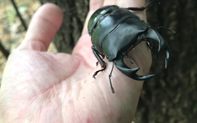
An Exciting Search! Catch the Phantom Giant Stag Beetle! Where Can You Find This Elusive Species?
Living Things- 116 plays
- YouTube
This video, titled "I Found 5 Stag Beetles! MAX EXCITEMENT!" (まさかのオオクワガタ5匹GET!テンションMAX), was released by "Yamame CHANNEL" (やまめCHANNEL). The giant stag beetle is one of the largest stag beetles inhabiting Japan. It lives in the deep woods in tree hollows, as introduced in the video. They range from 2 to 7 centimeters in length, but larger ones over 9 centimeters have been found in some cases. Many children are interested in these insects in the wild, and often go out to catch them with their nets and cages. Keeping stag beetles is also a fun hobby for adults. In Japan, some people make a living by capturing and selling stag beetles like the one in the video and selling them to collectors. -
 Video article 3:25
Sightseeing video of Tashirodaira Marsh, Aomori City, Aomori Prefecture! The contrast between cotton grass and the Milky Way is beautiful! Take a trip to taste the charm of the oldest marshland in the Hakkouda mountain range!
Nature Travel- 104 plays
- YouTube
Tashirodaira Marsh, Aomori City, Aomori Prefecture, Japan Video Introduction This video, titled "Time Lapse #129|Mt. Hakkoda|Tashirotai Marsh|A Marsh of Rhododendrons and Cottongrass|4K" (Time Lapse #129 Mt.Hakkoda Tashirotai ツツジとワタスゲの湿原 八甲田・田代平 4K), was uploaded by "aomorigonta." Tashirotai Marsh is a high-elevation marsh located in Aomori City, Aomori Prefecture, in Japan's Tohoku region. The video shows the beautifully blooming cottongrass and azaleas in early summer, as well as the beautiful Milky Way in the night sky, and other breathtaking views that are sure to captivate. Be sure to check it out before reading along. Tashirotai Marsh – Discover the Beautiful, Natural Scenery of Aomori, Japan Photo:Ryujin-numa at Tashirotai Onsen Tashirotai Marsh is located at the northern end of Towada-Hachimantai National Park in Aomori City, Aomori Prefecture, and is a high-elevation marsh designated as a Natural Monument. Tashirotai Marsh was formed from a caldera lake that was created by volcanic activity in the Hakkoda Mountain Range approximately 2 million years ago, and is located at a relatively low elevation at 560 meters above sea level. Furthermore, Tashirotai Marsh is the largest and oldest of all the marshlands in the Hakkoda mountain range. Ryujin-numa (Ryujin Marsh), located at the entrance to Tashirotai Marsh, is filled with emerald green water, and its mysterious scenery has made it a popular spot among both tourists and the people of Aomori Prefecture. Tashirotai Marsh – Autumn Leaves & Other Seasonal Views Photo:Rhododendrons in the Hakkoda Mountains, Aomori A variety of alpine plants can be seen in Tashirotai Marsh, and from June to July, cottongrass and azaleas bloom, providing beautiful scenery. In summer, zenteika and eleorchis bloom, and the yellow flowers of kinkoka are especially popular. The yellow flowers bloom all over the area and are a must-see, especially if you're a photographer or instagrammer. From late September to mid-October, it's a popular spot for tourists to view the colorful autumn leaves, and the entire marshland changes to a golden hue, fascinating visitors. Tashirotai Marsh has a 1,600-meter-long walking trail that takes about one hour to complete. Visitors can enjoy the beautiful nature and fresh air in the summer and fall. The Tashirotai Marshland Course – Journey Through Nature in the Hakkoda Mountains Photo:Autumn leaves at Tashirotai Onsen, Hakkoda Mountains The Tashirotai Marshland Course is a recommended way to enjoy the nature of the Hakkoda Mountain Range, and starts from Aomori City. Driving along the driving route through the foot of the majestic Hakkoda Mountains, visitors can enjoy viewing the marshlands scattered throughout the Hakkoda Mountain Range. During the summer, visitors can enjoy the blooming flowers and the greenery of the Hakkoda Mountain Range, and in the fall, the autumn leaves add color and beauty to the natural scenery. It's a course we definitely recommend trying if you have the chance. The highlight of the Tashirotai Marshland Course is the natural beauty of the marshland, which changes with the seasons. Tashirotai Marsh is a diverse wetland with a variety of aquatic plants and offers a wide range of natural attractions, from alpine flora to the mysterious marshes created by the melting snow of the Hakkoda Mountains. There are also a number of delicious restaurants and footbaths along the driving route. The course is 88.2 km long and takes 3 hours and 38 minutes to complete. We urge you to visit Aomori and take your time to enjoy the seasonal natural beauty of the Hakkoda Mountains. Summary of Tashirotai Marsh Around Tashirotai Marsh, you'll find Hakkoda Onsen, where you can relax in hot springs after a long day of hiking/walking. There's also lodging facilities, such as the Hakkoda Hotel, so if you like the outdoors, consider planning a trip to enjoy the natural beauty of the Hakkoda Mountain Range. Before visiting, you can also check live cameras that provide video of Aomori Prefecture Route 40 (青森県道40号線, Aomori Kendo Yon-juu Go-sen) to see the weather and traffic conditions. Parking is available for those coming by car. When sightseeing in Aomori, consider stopping by Tashirotai Marsh to experience the natural attractions of the Hakkoda Mountain Range. 【TripAdvisor】Tashirotai Marsh https://www.tripadvisor.com/Attraction_Review-g298241-d1721841-Reviews-Tashirotai_Wetland-Aomori_Aomori_Prefecture_Tohoku.html -
Video article 5:07
A Rare Shrew in Someone's Garden! He Wasn't Feeling Well, but After Giving Him Some Killifish He Chowed Down and Made His Way Back To the Bushes... Take Care Mr. Shrew!
Living Things- 39 plays
- YouTube
This video, titled "A Rare Shrew Found Its Way Into a Garden! After a Few Snacks He's Back to the Bushes!" (庭にいたトガリネズミにメダカのエサをやりました), was released by "pxh01252." This video captures a shrew in the wild! The shrew is not a mouse, but a member of the mole family, and is said to be the smallest mammal in the world. The shrew that lives in Hokkaido is listed as an endangered species on the Red List of the Ministry of the Environment. They are small, at only about 2 cm in length (their tail is about 3 cm), and you can easily understand how small they are when compared to the clover in the video. They look adorable as they eat, moving their narrow, pointy snout around like a cute character in a picture book. There are many things about shrews that we don't know about, so take this chance to see what they're like! -
Video article 2:19
Mt. Sobo - Easy Mountain Climbing and Hiking Courses Through Valleys and Lush Virgin Forests! Famous Peaks and Breathtaking Views in Oita and Miyazaki Prefectures!
Travel Things to Do Nature- 46 plays
- YouTube
Mt. Sobo Video Introduction This video, titled "Kobara Gorge [Gorge Walking Video] Sobo, Katamuki and Okue Biosphere Reserve" (神原渓谷【渓谷散策動画】祖母・傾・大崩ユネスコエコパーク), was uploaded by "Sobo, Katamuki and Okue Biosphere Reserve" (祖母・傾・大崩ユネスコエコパーク). Mt. Sobo, one of the 100 Famous Japanese Mountains, is the source of Kobara Gorge. Designated as Sobo-Katamuki Quasi-National Park, visitors can enjoy the beauty of the fresh greenery in summer and colorful autumn leaves in fall while enjoying a relaxing hiking experience. The Sobo, Katamuki and Okue Biosphere Reserve – Tons of Popular Tourist Attractions Photo:Takachiho Gorge Straddling Oita and Miyazaki prefectures, the area surrounding Mt. Sobo, Mt. Katamuki, and Mt. Okue is home to lush virgin forests, numerous valleys, and rare flora and fauna. The area is known as the "Sobo, Katamuki and Okue Biosphere Reserve." The Oka Castle Ruins, the motif of Kojo no Tsuki, a famous Japanese song, as well as Harajiri Falls, selected as one of the top 100 waterfalls in Japan, and Takachiho Gorge, a place of scenic beauty and natural monument, are also located in the area. In addition, popular sightseeing spots such as Seiun Bridge, which is the largest bridge on a national highway in Japan, are scattered throughout the area. In order to protect the area's rich natural environment, the municipalities in the vicinity of the Mt. Sobo, Mt. Katamuki, and Mt. Okue mountain ranges have launched efforts to have the area registered as a UNESCO Eco-Park (Biosphere Reserve). Having been recognized as a registered site in 2017, the area is expected to conserve biodiversity, revitalize the local community, and serve as a center for environmental education and research. Mt. Sobo - Virgin Forests and Beautiful Valleys, Popular Among Mountaineers Mt. Sobo has an elevation of 1,756 meters and is located on the borders of Oita and Miyazaki Prefectures, and has been selected as one of the 100 Famous Japanese Mountains. It is also known for its rich natural forests, numerous valleys suitable for exploring waterfalls, and is a treasure trove of rare wildlife, with animals like the Japanese serow, which is a protected species. While there are well-maintained climbing routes and walking trails, the trail near the summit is a steep mountain path that involves rocky climbing. Mt. Sobo - Enjoy Extensive Hiking Trails Source :YouTube screenshot The Kobara Gorge Trekking Course, which climbs from the first to the fifth station of Mt. Sobo, is a course that's great for shorter mountaineering trips, with well-maintained trails and promenades. The video introduces the highlights of this trekking course. Gyouran Falls, located just outside the entrance of the first station, is one of the 100 Views of Oita. [Video] 0:38 - Gyouran Falls Ahead you'll find Oyashiro Falls, where it's said that Shugendo monks once purified themselves to reach the summit of Mt. Sobo. [Video] 1:07 - and 1:53 - Oyashiro Falls Other highlights include the fifth station hut, which is the turnaround point of the course, "Seirei no Ki" (精霊の木, lit. 'Spirit Tree'), a mysterious-looking tree with several intertwining trunks, and "Nezame Falls" (寝覚の滝), which has a drop of about 10 meters. [Video] 1:21 - The Fifth Station Hut [Video] 1:34 - Seirei no Ki [Video] 2:00 - Nezame Falls On the downhill route, stone walls that are believed to be the remains of a lumber trail, which was used to transport lumber, can still be seen, and precious remains of various industries can also be seen. An Easy Hike Up Mt. Sobo - Enjoy a Gorge Walk Recommended for Beginners The "Fujikawachi Gorge Walking Course" is recommended for a short mountain climbing, hiking, or waterfall touring trip on Mt. Sobo. The valley is dotted with unique spots that are great for taking Instagram photos, such as "Senmaidaira" (千枚平) where you can play in the water, "Hyotanbuchi" another place surrounded by nature, and "Odoiko Doi," an interesting rock formation that looks like an irrigation canal. Visitors can also use campgrounds with bungalows and camp sites, and "Fujikawachi Yu-topia," a day-trip hot spring facility. Summary of Hiking Information for Mt. Sobo Photo:A woman enjoying mountain climbing The popular Mt. Sobo/Kobara Gorge offers a relaxing experience for both body and soul, with waterfall tours and light hiking. The Kobara Valley Trekking Course and the Fujikawachi Valley Walking Course are great for beginners to try. However, climbing Mt. Sobo is not completely free from danger of accidents and other hazards. Please be sure to double check climbing routes and gather information on the day's weather and climbing conditions before setting out on the trail. A direct bus service runs from Bungo Taketa Station to the Mt. Sobo trailhead (Kobara), and a parking lot is also available. In the video, you can enjoy the rich nature and beautiful scenery of Mt. Sobo, the trekking course in the Kobara Valley and its attractions with vivid footage. In addition, spots where you can take awesome Instagram photos are introduced with still images as examples. be sure to check it out so you can get some photo ideas of your own! 【Official Website】Sobo, Katamuki and Okue Biosphere Reserve http://sobokatamuki-br-council.org/home-en -
Video article 1:29
The 83x Optical Zoom Is Phenomenal! Introducing the Nikon Coolpix p900, Which Can Even See the Craters on the Moon!
Life & Business- 16 plays
- YouTube
This video, titled "Nikon coolpix P900 83x optical zoom world record - video test on moon", was released by "nature tv Lothar Lenz." Nikon's Coolpix p900 is a digital camera with an unparalleled zoom function. In this video, you can check out the amazing zoom capabilities of the Nikon Coolpix p900! One of the features of this digital camera is its 83x optical zoom. It's so powerful that you can clearly see the craters on the surface of the moon. The camera is equipped with a super ED lens with high chromatic aberration correction capability, so even the rough texture of the Moon's surface can be clearly seen. When you watch the video, you'll feel as if the moon is right in front of your eyes! -
Video article 7:07
Cape Kiritappu - Enjoy a View of Cute Otters Playing in Hokkaido! Observe the Wildlife of Japan at This Popular Sightseeing Location!
Living Things- 3.67K plays
- YouTube
Video Introduction This video, titled "Cape Kiritappu, Hokkaido|Wild Sea Otters Floating in the Sea|2020" (北海道霧多布岬 ぷかぷか浮かぶ 野生のラッコ 2020), was uploaded by "Shinji kawamura." The video captures endangered sea otters playfully swimming and relaxing at Cape Kiritappu, a place where you can encounter otters, foxes, and other wildlife of Japan. It's a great place for taking Instagram photos as well, so be sure to check it out. Don't forget to follow along with the video! Sea Otters – An Endangered Species on the Decline in Japan Photo:A raft of sea otters The main habitat of wild sea otters is the area from the California coast through Alaska and the Aleutian Islands to the coast of the Kamchatka Peninsula. Overfishing has led to a decline in the wild population, and it's estimated that more than 3,000 sea otters perished when an oil tanker ran aground in Alaska. Although the number of sea otters in the wild temporarily declined to less than 2,000, active conservation efforts have helped the population recover to more than 100,000. On the other hand, the number of sea otters kept in aquariums in Japan has continued to decline from 122 in 1994, and by 2021 there will be only 4 in Japan. Sea otters, which are designated as an endangered species, are prohibited from being imported from outside of Japan. Currently, because of declining reproductive capabilities and aging populations, further breeding of sea otters kept in Japan becoming more and more difficult. Because of this, it's not unlikely that there will come a day when sea otters can no longer be seen in aquariums in Japan. Where to See Sea Otters in the Wild in Japan Photo:Cape Kiritappu, Hokkaido There was a time when wild sea otters were no longer seen in the waters around Japan due to overfishing, but since 1980, there has been a string of sightings along the eastern coast of Hokkaido. In recent years, wild sea otters have been seen in Japan mainly in three areas along the eastern coast of Hokkaido. One is Cape Kiritappu, which is introduced in the video, and the others are Cape Nosappu in Nemuro, which is located on the northeast side of the cape, and Moyururi Island, an uninhabited island off the Kombumori fishing port between Cape Kiritappu and Cape Nosappu. Breeding has been confirmed on both Cape Kiritappu and Moyururi Island. Of these three locations, the highest probability of observing wild sea otters from land is at Cape Kiritappu. The sight of wild sea otters, both parents and offspring, floating in the sea, is both funny and cute. [Video] 0:19 - Wild Sea Otters Swimming With Their Offspring in Their Arms Sea Otters at Cape Kiritappu - The Best Times and Where to See Them Photo:An otter Wild sea otters can be seen throughout the year around Cape Kiritappu. However, your chances are low during bad weather, such as fog or high waves. It's said that the chance of seeing sea otters on a clear day is only a 1 in 3 chance, so weather is also an important factor. The best place to see them is where the waves are most calm. The probability of seeing them is higher on the north side of the cape and around reefs. If you're lucky, you can see wild sea otters up close, but we recommend bringing a telescope or binoculars in order to clearly see their appearance, behavior, and facial expressions. You can check out the sea otters napping and eating in the video. [Video] 1:50 - Sea Otters Relaxing and Taking Naps [Video] 4:28 - Sea Otters Eating Shellfish off Their Stomachs Summary of Otters at Cape Kiritappu The number of sea otters kept in aquariums has drastically decreased due to difficulties in breeding in Japan. Wild sea otters, on the other hand, a species that once vanished due to overhunting, can now be seen in the waters around Japan. The eastern coast of Hokkaido, where sightings are particularly common, is now quite popular. Cape Kiritappu is a popular spot to see rare wild sea otters from land. If you happen to see them during a visit to the area, consider yourself lucky! 【TripAdvisor】Cape Kiritappu https://www.tripadvisor.com/Attraction_Review-g1120924-d1553698-Reviews-Kiritappu_Cape-Hamanaka_cho_Akkeshi_gun_Hokkaido.html -
Video article 4:48
Mountaineer Ken Noguchi Talks About Environmental Issues. The Climber Who Conquered the Mountains of the World, Now Spends His Time Cleaning up the World Heritage Site Mt. Fuji, With Children.
Celebrities Nature- 191 plays
- YouTube
The Cool Choice Project The Cool Choice Project is an educational activity that was launched in 2015 to introduce the efforts of the Ministry of the Environment to tackle global warming and call on all people to help fight global warming caused by carbon dioxide. Ken Noguchi, a world-famous, professional mountaineer, and the youngest person to climb the Seven Summits, talks about COOL CHOICE in a video interview titled "Our COOL CHOICE: Mountaineer Ken Noguchi|COOL CHOICE" (私たちができるCOOL CHOICE 登山家 野口健|COOL CHOICE). Who Is Ken Noguchi? Source :YouTube screenshot Maybe the profile of the alpinist (professional mountaineer) Ken Noguchi is more appropriate than the mountaineer Ken Noguchi. Mountaineer Ken Noguchi- No, scratch that, PROFESSIONAL mountaineer Ken Noguchi, was born in Boston, Massachusetts, to a Japanese diplomat father and an Egyptian mother. He first came to Japan when he was four years old, and at first, wasn't able to speak any Japanese. His parents also divorced when he was in elementary school. When he was suspended from high school, he received a copy of "Risking My Youth on the Mountains" by mountaineer Naomi Uemura and had his first mountain climbing experience. Even when he was unsure of what to do after graduating from high school, this book inspired him to enroll in Asia University with the goal of conquering the Seven Summits. Ken Noguchi is currently married, with a wife and daughter. It became a hot topic on a TV variety show when it was revealed that he and his wife had lived apart for 15 of their 16 years of marriage and that he had set up a separate house in Otsuki, Yamanashi Prefecture, far from his home, and that even when he was in Japan, he stayed there. His daughter, Eko Noguchi, is a TV personality and mountaineer that does mountain climbing activities with her father. You can find more information about Ken Noguchi and his daughter on Twitter and blog, so if you're interested, be sure to follow him. Source :YouTube screenshot Ken Noguchi Profile ・ Height 169 cm (5'6") ・ Blood type A ・ Alpinist (professional mountaineer) and t.v. personality ・ Visiting Scholar, Asia University -Biography- ・ Climbed Mont Blanc, the highest peak in the European continent, at the age of 16. ・ At the age of 17, climbed Mt. Kilimanjaro, the highest peak on the African continent. ・Set the record for the youngest person to climb Mt. Everest at the age of 25. ・ Established the Sherpa Fund for Sherpa orphans who died in 2000 ・ Established the Manaslu Fund in 2006 to support children's education in Sama Village ・ Currently engaged in cleaning and climbing the Himalayas and Mt. Fuji as a representative of NPO PEAK + AID Environmental Protection Message From Mountaineer Ken Noguchi Source :YouTube screenshot At 1:00 in the video, Noguchi talks about his reasons for wanting to clean up the environment. A truly admirable task. When climbing Everest for the first time, he noticed there was a lot of garbage, some of which had Japanese writing on it. According to the Sherpas, Mt. Fuji is famous for being one of the most trash-filled mountains in the world, and the Japanese climbers are considered a nuisance because they just kept littering. Hearing this, Noguchi's ego as an alpinist began to change. From 2:38 in the video, Noguchi says, "Above all, it's important to understand our impact on nature." Without mountains, there'd be no mountaineering. Understanding this, Noguchi desired to keep clean the mountains that he treasured so. If you love the sea, you clean the sea. The first thing to do is to discover a connection with nature, even if it's subjective, just wanting to clean the place that you love, that's a start. Summary of Professional Climber Ken Noguchi Source :YouTube screenshot In addition to his work as a mountaineer, Ken Noguchi also focuses on environmental education and organizes classes to clean up mountains around Japan, including Mount Fuji. You can see some of his activities at 2:44 in the video. We hope you take a look at Mr. Noguchi's interview and think about your own impact on the environment. 【Official Website】Ken Noguchi Official Website http://www.noguchi-ken.com/ -
Video article 5:38
Taste the great outdoors at Kamikochi in the Japanese Alps, a spectacular sightseeing spot in Matsumoto City, Nagano Prefecture, Shinshu! Surrounded by greenery full of negative ions, spend a healing time.
Nature- 149 plays
- YouTube
Introduction of "Japan Alps Kamikochi" sightseeing video in Matsumoto City, Nagano Prefecture This video, titled "LEAP | Kamikochi (上高地) - Japan - UHD 4K," was released by Jonathan Teo. It shows an aerial view of Kamikochi, a tourist resort area overflowing with natural beauty in Nagano Prefecture. Kamikochi, located in Matsumoto City in western Shinshu, is a scenic, mountainous area situated at an elevation of approximately 1,500 meters above sea level. The entire area makes up Chubu Sangaku National Park (中部山岳国立公園), and is a base for climbing the Hotaka Mountain Range (穂高連峰) and Mt. Yari (槍ヶ岳). If you want to enjoy the beautiful scenery, plan a trip to Kamikochi and explore the mountain route! Recommended Sightseeing Spots in Kamikochi Photo:Kamikochi, Nagano Prefecture After the opening of the mountain, many tourists flock to Kamikochi, which has a series of peaks that are coveted by alpinists, for the purpose of mountain climbing. When climbing in Kamikochi, be sure to get your fill of the unique mountain scenery. Kappa Bridge (河童橋), the symbol of Kamikochi, is a popular spot where you can enjoy a great view. Be sure to also check out Taisho Pond, Myojin Pond, and Tashiro Pond, which are known for their natural beauty. At 0:53 in the video, you can see the Azusa River glowing a cobalt blue. Key Points to Remember When Visiting Kamikochi Photo:Kamikochi, Nagano Prefecture Kamikochi is a fun mountain for both beginners and advanced climbers. If you're looking for a casual hike, consider planning a day trip. The climate in the mountains can change easily, so be sure to suitable clothing when climbing in the Kamikochi area. Also, be sure to bring maps, drinks, and emergency food in your luggage just in case. Inns and Souvenir Shops at Kamikochi in Shinshu, Nagano Photo:A hot spring at an inn There are a number of hot spring inns and tourist hotels in the area around Kamikochi. After a day of hiking, we recommend staying at an accommodation with a hot spring to relax and rejuvenate. There are also many tourist attractions nearby, including restaurants serving local gourmet food and souvenir shops. Summary of Kamikochi, Located in Shinshu, Nagano Photo:The scenery of Kamikochi, Nagano Prefecture There are many scenic spots like the ones shown in this article's video, in Kamikochi. Walking around while enjoying the unique mountain scenery is sure to leave you feeling refreshed. To protect the environment around Kamikochi, personal vehicles are prohibited in and around the area. Park your car at the parking lot in Sawatari before Kamikochi and use the shuttle bus to get there. 【Official Website】Kamikochi Official Website|Area Introduction https://www.kamikochi.or.jp/learn/spots 【Tripadvisor】Kamikochi https://www.tripadvisor.com/Tourism-g12830931-Kamikochi_Matsumoto_Nagano_Prefecture_Koshinetsu_Chubu-Vacations.html -
Video article 4:00
Superb 4K video of beautiful rice fields in Aizuwakamastu City, Fukushima Prefecture! The scenery of golden rice ears dyed by the setting sun is soothing.
Nature- 366 plays
- YouTube
Video introduction of rural landscape of Aizuwakamastu City, Fukushima Prefecture To us Japanese, our staple food is rice. And where there is rice, there are rice paddies! You'll be completely absorbed by the view of the rice paddies during the autumn season that the 4K video “Japan Rice Paddies in autumn afternoon-views of rice paddies before the autumn sunset 4K (Ultra HD)(Japan Rice Paddies in autumn afternoon - 田んぼの風景・秋の夕暮れ前 4K (Ultra HD))” has to offer. The place where they shot the footage is the paddy field area in Aizuwakamastu of the Fukushima prefecture, in the rice-producing district of Japan's Tohoku region. From the beginning of the video, you can see the Japanese pampas grass around the rice paddy, and from 1:19, the ears of rice slowly being colored into a golden hue can be seen as well. The singing of the insects combined with the melody of the nearby river also relaxes the mind and makes you feel at peace. These kind of rural landscapes aren't uncommon in Japan either. The most Instagrammable, breathtaking sights to behold are the “Senmaida” and the “Tanada”, which are rice paddies or rice terraces that are cut into the steep mountain slope in a stair-like shape. This miraculous scenery is the crystallization of the wisdom of our ancestors. How Much Do You Know About Japan’s Paddy Fields? Photo:Rural landscape The scenery of Japan’s rice paddies is said to be the absolute perfection of inner peace and relaxation. However, how much do you know about Japan's rice paddies? The scientific name for Japanese rice is "Japonica rice" and as you've probably guessed, it originates from Japan. In the history of paddy field cultivation, Indica rice was cultivated in Southeast Asia. However, this rice is different from Japonica rice. The rice eaten in the present day, which has a special characteristic that makes it suitable for the Japanese climate, has a long history of agriculture in Japan. Photo:Rural landscape So, we will now introduce some basic knowledge about the rice paddies of Japan. First of all, the map symbol of a rice paddy is 2 lines. This symbolizes the “Aze” (the furrow between the paddy fields). The rice paddy is thought to be part of an idyllic scenery of nature. However, it is a man-made agricultural land formation, and the furrows are man-made paths between each rice paddy so people can work on the fields. Between the furrow and the rice paddy, there are waterways that help manage water. Paddy fields are measured in units called “Tan” and 1 Tan is about 991.74 square meters big. Rice Paddies and the Divine Photo: White rice Shinto is an original religion of Japan and deifies nature. The highest object of worship is the Emperor. Every year in November, there is The Niiname Festival(新嘗祭,Niiname-sai), held in the Imperial palace, in which the emperor prays for a bountiful harvest in the coming year. During this time, grains that are harvested from a lucky direction as designated through divination, will be eaten by both the Emperor and Empress. As you can see, for Japan, planting rice is not just an act of agriculture; it has significant cultural relevance as well, and rice was also used to pay annual tribute (presently known as taxes) in the past. Therefore, rice paddies were an important infrastructure that have supported the very heart of Japan since ancient times. How to Make Paddy Fields Photo:Rice planting Rice cultivation is in autumn. Depending on the region, however, usually the preparation of rice beds and seedlings start around March. There are many things that need to be done to prepare for rice planting as well: repairs on furrows, spreading of fertilizer, plowing and irrigating the fields ( to prevent damage from weeds or water leakage), filling the paddies with water, and then finally planting the rice seedlings. Come summertime, weed killers and pesticides are used to manage the growth of the rice, and in autumn the rice is harvested, some made into seedlings again, and the rest is threshed and put on a rice rack to dry. Referred to as "tilling", this act involves creating hills and soil beds in the rice field, as well as creating ice-field furrows and dams. In the modern day, much of the work is mechanized, however, in the past this was all done by hand. Summary of Japan’s rice paddies Photo:Rice paddy in Summer A rice paddy and a regular farm field are very different in terms of plowing, and grains other than rice are made in regular fields but not in rice paddies. That just goes to show how special of a crop rice is to the Japanese people. Also, because rice paddies are abundant with water, many living creatures gather near them, such as the aquatic stink bug, the diving beetle, the pond snail, and sparrows. Sometimes damage to crops does occur, however, there is a very rich ecosystem within the paddy fields. Recently, the aging of the rice farmers has led to many rice fields being fallowed. The original scenery of Japan, “Sunset on the rice paddies” is an incredible view that we want to preserve for future generations. -
Video article 3:01
The Northern Pika of Japan: Learn About the Cute Critter Known as the "God of Rocky Lands" and Found in the Outdoors of Hokkaido. Also See Its Characteristic High-Pitched Cry!
Living Things- 3.17K plays
- YouTube
An Introduction to Northern Pika! This is a video on the ecology of Northern Pika, an endangered species in Hokkaido. The video, titled "Keep it up! Northern Pika - He can do his best. Pika" (頑張れ!エゾナキウサギ He can do his best. Pika), was released by "Shinji Kawamura." The Northern Pika, is a small mammal of the ochotonidae family, and its identifying characteristic is its high pitched cry. In Japan, they only live in high lands like Mt. Daisetsu, Mt. Yubari, and Mt. Hidaka in Hokkaido. Their distinct high pitched cry can be seen in the video from 1:09. The Northern Pika is said to have arrived in Japan from the Siberian continent during the ice age. In this video, you can see the lives of cute, wild Northern Pika. Please enjoy the video showing the ecology of Northern Pika. What is the Northern Pika? Photo:Northern Pika The Northern Pika is also called the "God of Rocky Lands" due to its habit of running around the rocky land of their natural habitat. Hokkaido’s aboriginal Ainu people used to call the Northern Pika "Cicit Cu Kamuy" (チチッ・チュ・カムイ, roughly "The Cheeping God") in Ainu language. The mouse-like Northern Pika is very small, weighing only about 60-150 grams, with a length of 10-20 cm, and a lifespan of about 4-5 years, which is shorter than most pika. They are full of curiosity but very timid, so they are very rarely seen in public. Their natural habitat is the cold wind caves of the Daisetsuzan mountains located high above sea level that don't freeze during the winter. In Japan, these critters are also known to only inhabit Hokkaido. Their breeding period is once a year from spring to summer, and they give birth to 1 to 5 kittens at a time. How Northern Pika Survive Winter The Northern Pika is entirely vegetarian, feeding on every plant in the mountains and is sometimes called "the pacifist of the mountains." In the video from 0:42, there is a scene of an Northern Pika with leaves in its mouth. Northern Pika do not hibernate so they must make winter preparations before the snow piles up. This involves stocking their houses with food. They have the intelligence to dry plants such as leaves, turning it into a dry-grass-preserved food which allows them to survive up to 6 months of harsh winter. They store about a bucketful of food in each of the several locations in their territory. You can see this in the video from 1:49. Where Can I See Northern Pika? Photo:Beautiful Autumn Leaves at Daisetsuzan Northern Pika live in only limited parts of Hokkaido, so the possibility of encountering them is very low. If you do mountain climbing or participate in nature tours and go to photo points, you may have a chance to see them. Northern Pika only live in the wild, and it is said that they cannot be raised in zoos and laboratories. It is also impossible to keep them as pets. If you are attracted to the cute Northern Pika, we recommend that you buy a plush toy or photo book as a souvenir of your trip to Hokkaido. Summary of the Northern Pika In the introductory video, you can see scenes of Northern Pika running around busily searching for food. There's something soothing about looking at this little critter squeaking about. These animals are hard to find in the wild, so be sure to take the time to check out the videos and enjoy their cuteness! -
Video article 2:35
The Beautiful Landscape of Kumano Kodo, A World Heritage Site in Wakayama Prefecture. This Historic Power Spot Is Full of Stone Steps and Sacred Waterfalls, Perfect for Your Instagram!
Travel- 1.31K plays
- YouTube
The World Heritage Site, Kumano Kodo This video, titled "[4K] A World Heritage Site with Scenic Landscape: Kumano Kodo" ([4K] 世界遺産 絶景 熊野古道), is a sightseeing PR video that captures the breathtaking scenery of Kumano Kodo, a UNESCO World Heritage Site in Wakayama Prefecture (和歌山県, Wakayama-ken). Sacred Sites and Pilgrimage Routes in the Kii Mountain Range, a World Heritage Site, includes Yoshino Omine, Kumano Sanzan, and the Sacred Sites and Pilgrimage Routes of Koyasan (Mt. Koya). Among them, the route from Kumano Sanzan's Daimonzaka (大門坂, Daimonzaka), to Nachi Falls (那智の滝, Nachinotaki) is one of the most popular tourist routes, where you can enjoy the cultural scenery. It takes about 15 minutes to get to Daimonzaka by car from Nachi Station on the JR Kii Main Line (紀伊本線, Kiihonsen). This video captures the route from Daimonzaka to Nachi Falls in beautiful 4K footage. Enjoy the natural beauty and sacred temples and shrines in the video. Kumano Kodo- A World Heritage Site Source :YouTube screenshot Kumano Pilgrimage Routes (熊野参詣道, Kumano Sankeido) is an umbrella term for Nakahechi Route (中辺路, Nakahechi) which runs from Tanabe to Kumano Hongu Taisha Shrine (熊野本宮, Kumanohongu), Ohechi Route (大辺路, Ohechi) which runs along the coast to Nachi Shingu (那智新宮, Nachishingu) along the coastline, and Kohechi Route (小辺路, Kohechi) which runs from Koyasan to Kumano Hongu Taisha. In addition, the Kii Route (紀伊路, Kiiji), accessible from the Kii area, the Ise Route (伊勢路, Iseji), accessible from Ise, and the Omine Okugakemichi Route (大峯奥駈道, Omineokugakemichi), which leads from Yoshino Omine in Nara to Kumano Hongu Taisha Shrine, are some of the historical hidden gems in the area. Kumano Kodo is known as a historical power spot that has been used by many people since ancient times. If you’re planning on visiting Kumano Kodo, we also recommend getting a Kumano Kodo Stamp Book (熊野古道押印帳, Kumano Kodo Oincho) to gather seals. A Pilgrimage to the Historical Kumano Kodo! ©T-KIMURA Modifying The natural trails of Kumano Kodo are paved with cobblestones. Make your way through the historical cobblestone trail and through the torii gates to make the pilgrimage to Kumano Hongu Taisha Shrine and Kumano Nachi Shrine (熊野那智大社, Kumanonachitaisha), introduced at 1:23 in the video. At 2:00, you can see the breathtaking sight of Nachi Falls. Located at Hiro Shrine (飛瀧神社, Hirojinja), an associated shrine of Kumano Nachi Shrine, and is one of the three most famous waterfalls in Japan. The solemn waterfall, which is considered to be a sacred object of worship, is so beautiful that you can't help but lose track of time as you gaze at it. Other Sightseeing Spots Around Kumano Kodo Photo:Kamikura Shrine There are many more sightseeing spots around Kumano Kodo! There's the former site of Kumano Hongu-taisha, which was moved to its present location in 1889, called Oyu no hara Kumano Hayatama Shrine (熊野速玉大社, Kumanohayatamataisha), where Kumano Hayatama no Okami (熊野速玉大神, Kumanohayatamanookami) and Kumano Fusumi no Okami (熊野夫須美大神, Kumanofusuminookami) are enshrined, Kamikura Shrine (神倉神社, Kamikurajinja), a shrine with a huge rock called "Gotobiki Boulder" as its deity atop the 500 stone steps, Seiganto Temple (青岸渡寺, Seigantoji), Tamaki Shrine (玉置神社, Tamakijinja), Doro Gorge (瀞峡, Dorokyo), which is a huge valley inside Yoshino Kumano National Park (吉野熊野国立公園, Yoshinokumanokokuritsukoen), Tanise Suspension Bridge (谷瀬の吊り橋, Tanisenotsuribashi), Yunomine Hot Springs (湯の峰温泉, Yunomineonsen), Kawayu Hot Springs (川湯温泉, Kawayuonsen), and many others. You may want to consider visiting Kumano Kodo in conjunction with festivals and events such as the annual Kumano Hongu Taisha Shrine Festival (熊野本宮大社例大祭, Kumanohongutaisha Reidaisai), Funatama Shrine Festival (船玉神社祭, Funatamajinjasai), the Yata Fire Festival (八咫の火祭り, Yatanohimatsuri), and more. There are also restaurants, cafes and eateries aroundKumano Kodo to help you relax after a long journey. Summary of Kumano Kodo Photo:Kumano Kodo in Fall We hope that this video and article has inspired you to visit Kumano Kodo, a historic and famous tourist attraction. There are many Instagrammable views, so take the time to take in the sights. The Kumano Kodo pilgrimage route includes steep slopes such as Koyazaka (高野坂, Koyazaka) and Tomitazaka (富田坂, Tomitazaka), so wear clothes that are easy to get around in. After the pilgrimage, we recommend that you take a refreshing dip in a hot spring, such as at "Boukido" in the Nachi Katsura area. Some travel agencies offer Kumano Kodo walking tour plans, so if it's your first time visiting, consider giving it a try. Be sure to watch the video to see the beautiful views of the Kumano Kodo! 【Official Website】Kumano Kodo|Kumano Hongu Taisha Shrine Tourism Association https://www.hongu.jp/en/ 【Tripadvisor】Kumano Kodo https://www.tripadvisor.com/Attraction_Review-g1023661-d7902795-Reviews-Kumano_Kodo_Pilgrimage_Routes-Tanabe_Wakayama_Prefecture_Kinki.html -
Video article 3:32
Climbing the 1015 stone steps of "Hoshuzan Risshakuji Temple" in Yamagata City, Yamagata Prefecture, one is met with a spectacular view. The temple, built on a precipitous cliff, is a scenic spot where Matsuo Basho, the famous haiku poet, wrote a poem!
Art & Architecture Travel- 534 plays
- YouTube
Hoshuzan Risshakuji Temple, Yamagata City, Yamagata Prefecture, Japan This video, titled "Risshaku-ji Temple Temple 4K - Risshaku-ji in Yamagata" (宝珠山立石寺 4K - Risshaku-ji in Yamagata), was uploaded by "channel WASABI." It explores Risshaku-ji Temple, a National Site of Scenic Beauty in Yamagata Prefecture, Tohoku, Japan. Risshaku-ji Temple in Yamagata City, Yamagata Prefecture is an ancient temple opened by a monk in 860 A.D. It is one of the most famous temples in Japan's Tohoku region. It is most famous as the temple that Matsuo Basho made a haiku poem about, in his poetry book "Oku no Hosomichi." The poem goes like this- Deep silence the shrill of cicadas seeps into the rocks The temple suffered damage from fire several times between the Kamakura Period (1185~1333) and Muromachi Period (1336~1573). In the Edo Period (1603~1868), the temple was given a territory of 1,420 koku by the government and rebuilt the temple buildings. The temple currently owns a land of 330,000 tsubo where around 30 various sized buildings are built. It is one of the most famous tourist attractions in Yamagata Prefecture. Built on top of the tall steep stone cliff, Risshaku-ji Temple lays within the beautiful natural landscape of Zao Quasi-National Park. Here you can enjoy the beautiful seasonal views and elegance of nature. Yamagata Prefecture proudly boasts the temple as a National Site of Scenic Beauty in Japan. The video captures the beautiful Risshaku-ji Temple in stunning 4K quality. The sound of the piano adds to the beauty of Risshaku-ji Temple. The "Four Temple Pilgrimage" of Yamagata Prefecture Photo:Spring scenery at Risshaku-ji Temple Risshaku-ji Temple is spiritually associated with Hiraizumi Chuson Temple (平泉中尊寺 Hiraizumi Chusonji), Moutsu Temple (毛越寺 Moutsuji), and Matsushima Zuigan Temple (松島瑞巌寺 Matsushima Zuiganji), and the pilgrimage route to visit the four temples has become a popular tourist activity in Yamagata. There are many spots along the route that are great for taking Instagram pictures as well. Your trip isn't complete until you've collected a shuin stamp from all four temples! Making a trip to all four temples is sure to be an unforgettable experience. The Pilgrimage Route for Risshaku-ji Temple Photo:Yamadera (Yamagata Prefecture) The recommended route to visit Risshaku-ji Templeis shown below. 1. Start of the trail:Start here. The pilgrimage to Risshaku-ji Temple is more like climbing a mountain. (0:48 in the video) ↓ 2. Konpon Chudo Hall (根本中堂 Konponchudo) ↓ 3. Basho Mound (芭蕉塚 Bashozuka) ↓ 4. Treasure House (宝物殿 Takaramonoden) ↓ 5. Mountain Gate (山門 Sanmon) ↓ 6. Cicada Mound (せみ塚 Semizuka) ↓ 7. Nio Gate (仁王門 Niomon) ↓ 8. Inner Sanctuary (奥の院 Okunoin) (1:22 in the video) ↓ 9. Three-storied Pagoda (三重の小塔 Mieno kotou) ↓ 10. Kaizan Hall (開山堂 Kaizando), Nokei Hall (納経堂 Nokeido) (1:31 in the video) ↓ 11. Godai Hall (五大堂 Godaido) The route takes around 1.5 hours to complete, and you have to climb up 1,050 stone steps! From the start of the trail to the peak, you'll only walk up the steps. You won’t need special attire, just normal clothes and shoes are fine. You can complete a pilgrimage and get some light mountain climbing in at the same time! Take your time enjoying the history and culture of Risshaku-ji Temple. Other halls include Shoso Hall (性相院, Shosoin), Kinjo Hall (金乗院, Kinjoin), Chusei Hall (中性院, Chuseiin), and Kazo Hall (華蔵院, Kazoin). You can check the official website to see the map showing the exact locations of each hall. Tourist Attractions and Dining at Risshaku-ji Temple Photo:konjac at Risshaku-ji Temple The most famous dishes at the ancient Risshaku-ji Temple area are wild vegetable dishes and Japanese Soba - buckwheat noodle. The temple is well-known for being a mountain temple surrounded by the steep cliffs and magnificent mountain views. You can taste delicious Japanese dishes using wild vegetables grown on the mountain. Access to Risshaku-ji Temple in Yamagata prefecture Train:30 minutes by bus or taxi from JR Yamagata Station Car:15 minutes from the Yamagata Expressway Air:30 minutes from Yamagata Airport Risshaku-ji Temple is on top of a very steep cliff. There is a free car park for visitors. However, it is very small, so we recommend that you use public transport when possible. Hotels Around Risshaku-ji Temple If you're visiting Risshaku-ji Temple for a pilgrimage or sightseeing, we recommend staying at a hotel near JR Yamagata Station or JR Yamadera Station on the JR Senzan Line. Summary of the Serene Risshaku-ji Temple in Yamagata Prefecture Photo:Jizo statue Risshaku-ji Temple in Yamagata City, Yamagata Prefecture has been connected with Hie Shrine (日枝神社 Hie Jinja) by Shinbutsu-shugo. It is now completely merged with Risshaku-ji Temple, and In May every year, they have an event called the Sanno Festival. The Harsh climate of Yamagata brings the seasonal beauty of nature- cherry blossoms and plum trees in spring, fresh greenery in summer, beautiful autumnal foliage in fall, and snowy scenery in winter. It's a place where you can enjoy the natural landscape of Japan and majestic views year round. The views from Risshaku-ji Temple are shown at 1:57 in the video. With an elevation difference of approximately 160m, the view from Risshaku-ji Temple on top of the steep cliffs is something special. The video also shows the solemn atmosphere of the mountain temple and the beautiful changes that each season brings. Be sure to check it out if you haven't yet! ◆Risshaku-ji Temple◆ 【Address】4456-1 Yamadera, Yamagata, 999-3301 【Access】30 minutes from Yamagata by car 【Parking】Available. 10 free spaces 【Telephone No.】023-695-2843 【Official website】Risshaku-ji Temple https://www.rissyakuji.jp/ -
Video article 2:07
Why is Kakita River Spring Water, a Mysterious Clear Stream in Sunto-gun, Shizuoka Prefecture, Blue! Watch a video of the Kakita River, fed by melted snow from Mt! Also, the highlights of Kakita River Park with its power spots!
Nature Travel- 287 plays
- YouTube
Video Introduction to the Kakita River, a Mysterious Clear Stream Rare in Japan, Located in Sunto-gun, Shizuoka Prefecture This video, titled "Explore the Enchanting Crystal Waters of Kakita River with 8KVR!!!" (『静岡県清水町』が制作の『神秘の清流 柿田川 〜8KVRで体験!空中散歩と絶景癒しスポット〜) was uploaded by "Shimizu, Shizuoka" (静岡県清水町). The Kakita River is Japan's shortest Class 1 river, one of the three clearest rivers in Japan along with the Nagara River and the Shimanto River, and is fed by spring water from Mt. Fuji. In 1985, the Kakita River was selected as one of the "100 Famous Bodies of Waters" by the Kakita River Spring Group because of the purity of its water. Be sure to take a look at the beautiful 8K VR video of the clear stream created by the spring water from Mt. Fuji. The Kakita River, a Clear Stream Filled With Spring Water From Mt. Fuji! Photo:Spring water at Kakita River Park The Kakita River is a Class 1 river in the Kano River system located in Shimizu, Shizuoka, in Japan's Tokai Region. It boasts the largest volume of spring water in Japan, and most of the water in the Kakita River is spring water from melting snow and rainwater from Mt. Fuji that seeps into the Mishima lava flow. It is one of the most unique rivers in Japan. It is one of the three clearest rivers in Japan and is also designated as a Natural Monument by the government of Japan in the category of geological minerals. The Kakita River stays at a cool 15°C throughout the year, with a constant volume, allowing the Mishima Baikamo, an underwater plant unique to rivers, to grow in abundance, nurturing a rich natural environment that provides comfort to the local people. At one time, factories moved into the area to exploit the abundant spring water, and the deteriorating quality of the water made it uninhabitable for fish. However, thanks to the efforts of the local people to improve the water quality and protect the habitat for kingfishers and various fish, the Kakita River continues to flow as a clear and transparent stream. What Gives the Kakita River Its Blue Color? Photo:Spring water at Kakita River Park Kakita River Park is located upstream of the Kakita River. Originally the ruins of Izumigashira Castle built by Hojo Ujiyasu, a daimyo known as "The Lion of Sagami," this historic place is home to one of the most photogenic spots on the Kakita River. The "Wakima," is one of the sources of the Kakita River and can be seen from the observation deck of Kakita River Park. This place was originally used as a well by a nearby factory. The blue-colored source seen from the second observation deck is a mysterious beauty and has become quite popular on Japanese social media. The Kakita River spring water appears blue because of the water's ability to absorb red light. The deeper the water gets, the bluer it becomes. The color of the spring water changes slightly depending on the season, weather, and time of day, but the deepest and most beautiful blue can be seen in the mornings during the summer. Highlights of Kakita River Park Photo:Kifune Shrine at Kakita River Park, Shizuoka In addition to the Wakima, you can also enjoy a picnic at Kakita River Park! You can rent a picnic set at the Shimizu Town Tourist Information Center "Wakura Kakita River" and have a picnic without having to bring your own equipment. You can also rent equipment for activities such as badminton, dodgeball, and Othello/Reversi. Kakita River Park is located in the town of Shimizu in Sunto Ward, not Shimizu Ward, so be sure not to mix them up if you plan on visiting! Kifune Shrine, famous for boosting one's luck in love, is located in Kakita River Park. This shrine is a branch of Kibune Shrine in Kyoto and is dedicated to the god of water, but it has become known as a shrine for praying for love. On the approach to the shrine, there is a stone monument, and touching the stone shaped like a rice ball is said to bring good luck. There is also a mizu-mikuji (water fortune) that when placed in water makes the characters appear, making it a popular power spot for couples and those seeking love. Restaurants Near the Kakita River Photo:Tofu cuisine at Kitchen Kawasemi There are a variety of restaurants and cafes near the Kakita River. At the roadside stop Yusui no Michi (湧水の道), adjacent to Kakita River Park, you can find Kitchen Kawasemi (キッチンかわせみ) and Shokuji-dokoro Kawasemi Honkan (食事処かわせみ本館) where you can enjoy tofu dishes using fresh spring water from the Kakita River. At Kitchen Kawasemi, you can enjoy cold tofu and yuba (tofu skin) the freshest wasabi. Coffee brewed with spring water from the Kakita River is also available. Shokuji-dokoro Kawasemi Honkan offers a kominka (traditional Japanese home) experience, with reservations given priority. Here, the serve bento boxed lunches with a choice of either hot tofu or cold tofu made the famous spring water from the area. Also nearby is a store where you can purchase tofu ice cream, firm or soft tofu made spring water, green rice crackers, and coffee beans called Kakitagawa Yusui Blend (柿田川湧水ブレンド). Stop by after a stroll in Kakita River Park! A Brief Overview of Shimizu, Shizuoka Shizuoka Prefecture is the 10th largest prefecture in Japan based on population (3.5 million), and is located 1 hour from Tokyo and Nagoya via shinkansen (bullet train). Shimizu is a small town located in northeastern Shizuoka with a population of just 32,000. It's close to both the sea and mountains and even hot springs. Summary of the Mysteriously Clear Kakita River The Kakita River is one of the smallest rivers in Japan, at approximately 1.2 km long. However, it's so transparent that it is one of the three clearest rivers in Japan. The blue spring water gushing up from the earth, which can be seen from the second observatory in Kakita River Park, is a popular, photogenic spot. Kakita River Park is also a sightseeing spot where families can enjoy picnics and outdoor activities during the spring and fall. Nearby is Sun to Moon Kakitagawa, a large commercial facility that includes a movie theater and a shopping mall. When sightseeing in Shizuoka Prefecture, be sure to stop by Shimizu! 【TripAdvisor】Kakita River Park -
Video article 7:41
Isonokami Shrine – The Oldest Shrine in Japan. Discover Sacred Swords, and Ancient Amulets at This Shrine Surrounded by a Divine Forest in Kanagawa Prefecture
Travel History- 162 plays
- YouTube
Isonokami Shrine – The Oldest Shrine in Japan: Video Introduction This video, titled "[Nara / National Treasure] Rainy Scenery at Isonokami Shrine in NARA, JAPAN -" (【奈良/国宝】石上神宮 - Rainy scenery of the Isonokami Jingu Shrine in NARA, JAPAN -), was uploaded by "channel WASABI." This video, shot during autumn, shows both the beauty of nature and the divinity of the area. Be sure to check out the video before reading along. Isonokami Shrine – A Brief History of the Shrine Photo:Isonokami Shrine, Tenri, Nara Isonokami Shrine is located in Tenri, Nara, in Japan's Kansai Region, at the western foot of Mt. Ryuo. The haiden (拝殿, hall of worship) is the oldest existing hall of worship in Japan and is designated as a National Treasure. Isonokami Shrine has been worshipped as the ancestral deity of the Mononobe Clan, a powerful clan in the Asuka Period (circa 592-710 A.D.). The shrine is also known for its blessings of health and longevity, its power to heal illnesses, protect from disaster, and fulfill wishes, and is designated as the 19th site on the Shinbutsu Reijo Junpai no Michi, a pilgrimage route to sacred Shinto shrines and Buddhist temples. The pilgrimage route is made up of 152 sacred sites in Japan's Kinki region, including Ise Jingu Shrine. The Gods Worshipped at Isonokami Shrine Isonokami Shrine worships three main deities. Here we'll introduce them briefly. Futsunomitama no Okami – A sword that appears in Japanese mythology. The deity is said to have been inspired by the sword held by Takemikazuchi no Kami, a god of thunder. Furunomitama no Okami – Said to refer to one of the sacred treasures given to Nigihayahi no Mikoto (a god and ancestor of the Mononobe Clan) by Amatsukami Mioya, as well as its mysterious powers. Futsushimitama no Okami – A divine sword used by Susanoo no Mikoto when he defeated Yamata no Orochi, a legendary 8-headed dragon serpent, and the spiritual power of the sword itself. Chickens: Messengers of the Gods at Isonokami Shrine Photo:The sacred chickens of Isonokami Shrine, Tenri, Nara The 30 to 40 chickens at Isonokami Shrine are called goshinkei (御神鶏, lit "sacred chickens") and are designated as a protected species by the Japanese government. They are free-range chickens at Isonokami Shrine and welcome visitors to the shrine. Chickens, which appear in the Kojiki (Records of Ancient Matters) and the Nihon Shoki (Chronicles of Japan), are believed to be messengers of the gods, and their crowing is thought to ward off evil. On the temple grounds, Goshinkei Mikuji (御神鶏みくじ, sacred chicken mikuji), which come in containers shaped like chickens, and ema (wooden prayer plaques) depicting a chicken crowing at dawn, are also popular. [Video] 2:05 - Chickens at Isonokami Shrine Highlights of Isonokami Shrine Photo:Izumo Takeo Shrine at Isonokami Shrine, Tenri, Nara The tower gate, designated as an Important Cultural Property, was built in 1318 in the late Kamakura Period (1185-1333), and in the past, a bell was hung on the upper level of the gate. The space behind the hall of worship, which is the oldest in Japan and is designated as a National Treasure, is a consecrated ground, and serves as a sacred space where the shrine's deities reside. The worship hall of Izumo Takeo Shrine, an auxiliary shrine to Isonokami Shrine, has also been designated as a National Treasure. The historic and solemn atmosphere of the shrine as well as its divine appearance can be seen in the video. [Video] 3:25 - Izumo Takeo Shrine's Worship Hall Seven-Branched Swords, Divine Amulets & More Photo:Isonokami Shrine, Tenri, Nara The seven-branched sword of Isonokami Shrine is an ancient relic that has been handed down within the treasury of Isonokami Shrine. It's assumed to be the same as a sword which was presented by the Baekje people (an ancient Korean kingdom) many years ago. The uniquely shaped sword, measuring 74.8 cm in length, is made of iron and has three "branch" swords on each side. The amulet called Go-shinken Mamori, which represents this seven-branched sword, is said to be a lucky charm with the power to rescue someone on the brink of death. The shrine's shuin stamp also depicts a seven-branched sword. Summary of Isonokami Shrine Isonokami Shrine is known as a power spot and is visited by many people seeking blessings. In addition to Isonokami Shrine, there are many other interesting historical sightseeing spots in Nara Prefecture. If you're planning a visit to Nara, consider visiting Isonokami Shrine as well! 【Official Website】Isonokami Shrine Official Website|Tenri, Nara 【TripAdvisor】Isonokami Shrine -
Video article 2:34
This is the landing place of UFOs! Let's take a look at the spectacular power spot, Kizuro, Kumano City, Mie Prefecture, from the sky! The unexplored region known only to those in the know is a mysterious sight that will amaze anyone!
Nature- 715 plays
- YouTube
What is “Kizuro” in Kumano City, Mie Prefecture, an unexplored region of Japan? Aerial Video Introduction This video "Unexplored Japan (Kizuro) (日本の秘境 (木津呂))" was created by "hashieemov". Kizuro is an unexplored region in Japan in the town called Kiwa (紀和町, kiwachou). Kiwa is located in Kumano city, Mie prefecture in the Tokai region of Japan. It is one of the most uniquely structured settlements to be found in Japan and attracts many tourists as it is thought to be a power spot. It has also been featured in the Japanese TV show "Nani kore, Chinkyakkei" (What's this? 100 Famous, Bizarre Views) and looks identical to a location from the movie "Your name" (君の名は, kiminonawa). In this video, we introduce to you the Kizuro Village through aerial drone photography. Kizuro: An Unexplored Region of Japan. Why Is It Shaped So Strangely? Source :YouTube screenshot Kizuro Village is located in a basin surrounded by mountains in a town called Kiwa in Kumano city, Mie prefecture. It is situated in the center of a white, oval area of land with a river running through it. The unusual and unique shape of the terrain is one of the characteristics of this small, ancient settlement. You can take a look at the terrain from 0:07 in the video. Depending on which direction you look at it from, the terrain appears circular and the highest point from which you can see it is the top of Mt. Shimzau (嶋津山, shimazuyama) in Kumanogawa, Shingu in Wakayama prefecture. The mountain path is very steep and rugged so please take a map if you plan on climbing it. The mouth of the Kitayama river (北山川, kitayamagawa) which surrounds Kizuro Village is part of the Kumano pilgrimage which is registered as a World Heritage Site. The settelement of Kizuro is thought to have been formed approximately 1500 years ago after the eruption of a volcano caused the land to sink and was slowly eroded by the surrounding Kitagawa river, the shape of the settlement is still changing today. It has become a popular tourist spot because of its photographic terrain which looks similar to a UFO landing spot, with tour buses even operating in the area. There is an ancient practice in Asia called Feng Shui that can be used to forecast or predict fortune by reading the energy in an area. Feng Shui masters believe that the unique terrain surrounding Kizuro Village makes it a very important power spot. Being referred to as an "unexplored region" you would think that the area is very isolated, and therefore deserted, however in 2015 there were eleven people living in the area. The main industry is forestry, and lumber from the area (Kumano) is very valuable and is sold at a high price. Outdoor Activities in Kizuro, an Unexplored Region of Japan Photo:Camp In the opening of the video you can see a car, however there are very few car parks in the area and it could also be said that the access is rather inconvenient. However, a lot of outdoor activities can be enjoyed nearby such as camping, mountain climbing, an observation deck, rafting, Ikadanori and the flower grotto. It is a great spot to experience outdoor adventures! Kizuro Village Is Also a Popular Hot Spring Area Source :Official home page of the Yunokuchi Onsen The unexplored region of Kizuro is also popular as a hot spring area. Many people come to visit Yunokuchi Onsen which is surrounded by the Kumano mountains where the water is said to have healing benefits. Summary of Japan's Unexplored Kizuro Village Photo:Kizuro What do you think of Japan's Kizuro Village? If you decide to visit Kizuro Village, there are many other tourist spots you can enjoy in the area, such as the Maruyama-senmai Rice Field, Shishiiwa and Onigajou. You can access Kizuro from Kumano city center in approximately 60 minutes by car. -
Video article 2:43
The Precious Okinawa Rail – A Look at the Awkwardly Adorable Flightless Bird of Kunigami, Okinawa, Registered as a Protected Species!
Living Things- 807 plays
- YouTube
Introducing the Okinawa Rail - A Protected Species in Japan This video, titled “Wild Okinawa rail (Kunigami, Okinawa prefecture) May 11th-12th, 2019(野生の ヤンバルクイナ (沖縄県国頭村) 2019年5月11-12日) introduces the Okinawa rail, a protected species on the Red List of the Ministry of the Environment. The Okinawa rail is also a critically endangered species and a Specified National Endangered Species of Wild Fauna and Flora. They are flightless birds and live only in Okinawa. This video was taken in 2019 on the street in Kunigami, Okinawa prefecture. The bird is an endemic species found only in northern Okinawa prefecture, Kunigami, Ogimison, and Higashison, and is referred to as "Yanbaru." It's a very rare bird, not only in Japan but also around the world. The forest area located in the northern part of Okinawa is called the Yanbaru Forest. Kunigami Village, where wild Okinawa rail (Yanbaru Kuina) appear frequently, is called the Forest of Kuina. There is an Okinawa Rail Ecology Center, and the Yanbaru Kuina observatory is located there. The Ecology of the Okinawa Rail Photo:Okinawa rail The wild Okinawa rail is characterized by the following morphology and characteristics: ・Birds, Order Gruiformes, Family Rallidae, scientific name: Gallirallus okinawae ・Size: approx. 35 cm in length with a weight of 230 gramst ・Wild distribution:The woodlands near Mt. Yonahatake ・Eating habits:Omnivorous ・Nesting:They build nests on the grounds of the forest, and lay about 4 eggs in breeding season. ・They have vestigial wings and are unable to fly, but parent birds have bright red bills and beautifully striped feathers. Chicks have a protective coloring of deep black feathers. ・Their calls are distinctive, and very loud. The Origins of the Name "Yanbaru Kuina," and the History the Okinawa Rail Photo:Okinawa rail The first discovery of the wild Okinawa rail by experts was in 1981, which is actually quite recent. There are various kinds of Rallidae (rails) around the world, but it gained a lot of attention as the first rail species to be discovered in the wild. In Okinawa Prefecture, they were called by different names such as Agachi, Agacha, and Yamadui, depending on the region, and it turned out that they are a species indigenous to the region with a long history. Therefore, they were named Yanbaru Kuina from Yamadui, which means bird of the mountains, using the Kanji "山原"as a phonetic equivalent (pronounced Yanbaru in Okinawa dialect). Other than Yanbaru Kuina, Yanbaru Fumiru and Okinawa Kuina were other possible names. Summary of Very Rare Okinawa Rail Photo:An Okinawa rail crossing sign The Okinawa rail is an endangered species of wild bird that can only be seen in Yanbaru Forest on the main island of Okinawa. Even in Okinawa Prefecture, you cannot see them on remote islands such as Miyako Island. They are a very rare endemic species. The reasons for the decline in the Okinawa rail's population are due to deaths from car accidents and attacks by alien predators such as mongooses, Yellow fever mosquitoes, and stray cats. At 0:10 in the video, an Okinawa rail is seen crossing the road at a brisk pace, raising concerns about traffic accidents. Japan is still an island country with 70% of its land surrounded by forests, and there are many rare wild indigenous species that are only found in Japan, so it is said to be very important for the protection of indigenous species that we do not pollute the natural environment through overexploitation, nor bring dangerous alien species into the country without care. Currently, the Ministry of the Environment is taking the lead in protecting the Okinawa rail, breeding mates, increasing their numbers, and returning them to the wild. However, it is important not only to protect them strictly, but also to make people widely aware of Okinawa rails. In this way there are goods such as stuffed animals sold at roadside stations and airport shops in Okinawa. These awareness raising activities are also part of the important protection policies. -
Video article 1:55
Video of mountain climbing in the Hakuba mountain range of the Northern Alps, including the spectacular natural scenery, sea of clouds, and star-filled sky in Hakuba Village, Kitaazumi-gun, Nagano Prefecture, which you should see at least once!
Local PR Nature- 552 plays
- YouTube
Introduction of the official "Mountain Climbing in the Hakuba Mountain Range of the Northern Alps" video from Hakuba Village, Kitaazumi-gun, Nagano Prefecture, Japan. This official PR video of Hakuba village, titled “Hakuba village [Dramatic Nature Days – Mountain]"(白馬村公式ムービー【Dramatic Nature Days - Mountain】)” is a time-lapse video produced by the Hakuba tourist office. The Northern Alps' Hakuba Mountain Range is located in the middle of the Japanese archipelago. Its structure, which lies between the Japanese sea and the Pacific Ocean, creates dynamic scenery. This two minutes video features the beautiful views of the Hakuba mountain range and recommended tourist spots in Hakuba village. Events in Hakuba, Nagano Photo:Hakuba Village in the Spring Hakuba village in Nagano prefecture is a popular tourist spot in Japan. Tourists can enjoy various activities throughout the year, such as hot springs, mountain climbing, skiing, cycling, and camping. It is also famous as a summer resort where many tourists visit due to it's comfortable climate. The Northern Alps is a great location where people can enjoy various outdoor activities such as trekking and mountain climbing while seeing fabulous natural views including flowers, snow, wildlife, and more. The Northern Alps - The Mountaineer Mecca Photo:The Northern Alps The rugged mountains shown in the video are the Northern Alps. Hakuba Village is one of Japan's most famous mountaineering spots thanks to the Hakuba mountain range. The Japanese Alps and Mt. Fuji are two of the world's most sacred mountaineering destinations and attract many climbers every year, but the Hakuba mountain range has more than 17 of the most famous peaks. “Shirouma-dake,” “Shakushi-dake,” and “Yariga-dake” are well-known as “The Three Peaks of Hakuba.” Some of the peaks are: ・Goryu-dake (9,232 ft.) (~0:44) ・Karamatu-dake (8,845 ft.) (~0:49) ・Yariga-dake (9524 ft.) (~1:22) ・Shakushi-dake (9,225 ft.) (~1:26) ・Shirouma-dake (9,619 ft.) (~1:42) If you enjoy climbing, be sure to carry rain gear and a map, even if you're enjoying a beginner's trekking trail, as the weather in the mountains can change easily. In the Hakuba mountain range, you can see rare alpine flowers and animals that cannot be found in the plains. Taking a commemorative photo with the Hakuba mountain range in the background is a great way to remember your trip. Be sure to share it on Instagram! The Hot Springs of Hakuba Village Source :YouTube screenshot Hakuba village is very popular as a hot springs area. The most recommended spot is "Hakuba Yari Onsen" (白馬鑓温泉) in the middle of Yariga-dake. You can see this hot spring in this video at 0:33. The view of the rising sun and star sprinkled sky from the open air bath are remarkable! 100 people can stay at the Hakuba Yari Onsen lodge and about 15 people can stay in a tent. The Yari Onsen lodge is a great spot where visitors can enjoy both hot springs and nature. If you would like more information about other accommodations in Hakuba village as well as access information, please see the official website of Yariga Onsen or the Hakuba village tourist office's website. The Nagano Olympics in Hakuba Village Be sure to check out the following facilities used as competition venues during the Nagano Olympics: ・HAPPO ONE SNOW RESORT ・Hakuba Ski Slope ・Hakuba Cross Country Stadium "Snow Harp" Hakuba village is in a snowy area of Japan. Visitors can enjoy skiing or snow boarding in fresh powdery snow. You'll be amazed at the amazing snowscape that stretches as far as the eye can see. Summary of Hakuba Village Photo:Hakuba mountain and Oide Park in spring Hakuba village is a great tourist spot with fierce weather and rich natural surroundings. There are other attractive places that weren't shown in the video as well. For example, you can remnants of the Jomon period at Aoni in Hakuba village. Also there are other experienced based activities where you can feel the history and culture of Japan, such as making Tonbo dama (glass beads), watching fireflies, or making soba (Japanese noodles). You can enjoy the magnificent views of Hakuba mountain range in this video. The vast sea of clouds extending to the horizon (0:06) and the star sprinkled skies (1:08) will take your breath away. 【Official Website】Hakuba Village Official Tourist Website https://www.vill.hakuba.nagano.jp/english/ 【Official Website】Hakuba Village Office Official Website https://www.vill.hakuba.lg.jp/ -
Video article 3:05
An Encounter With the Specially Protected Rock Ptarmigan While Mountain Climbing! A Look at the Ecology of the Endangered Species and Where You Can Find It!
Living Things Nature- 557 plays
- YouTube
The Rock Ptarmigan - An Endangered Species This video, titled "Endangered Species|Rock Ptarmigan|A Precious Encounter Whilst Mountain Climbing|Special Edition (4k)" (絶滅危惧種 雷鳥 登山で出会った貴重なニホンライチョウ動画 特集 【4K】), was created by "Yamacchi channel" (やまっちchannel). It contains footage of the rock ptarmigan, a protected species in Japan, as well as the Crested ibis and Red-crowned crane. Due to the effects of global warming, the number of rock ptarmigan in Japan has dwindled to around 1,500 and it is now recognized as an endangered species. This video contains a compilation of footage of the adorable rock ptarmigan, which was spotted whilst mountain climbing. In this article, we'll introduce the rock ptarmigan, an endangered species! More About the Rock Ptarmigan, an Endangered Species Photo:Tateyama ptarmigan Said to have survived the ice age, the rock ptarmigan is now an endangered species belonging to the order Galliformes, family Phasianidae and genus Lagopus (キジ目キジ科ライチョウ属, kijimokukijikaraichouzoku). The subspecies of rock ptarmigan which inhabits Japan is a very adorable and friendly bird, making it a favorite among mountain climbers. It has a characteristic call that sounds similar to that of a frog. From 0:14 in the video you can see the rock ptarmigan at Mt. Senjo (仙丈ヶ岳, senjogatake), and at Mt. Tsubakuro (燕岳, tsubakurodake) from 1:38, Mt. Chogatake (蝶ヶ岳, chougatake) from 2:09, and Mt. Jonen (常念岳, jounendake) at 2:04. Rock ptarmigan chicks average 6 cm in height. A fully grown adult rock ptarmigan measures 37 cm in height and weighs approximately 400-600g. They lay their eggs in early summer from the beginning to the middle of June. The color of their feathers also changes depending on the season. In summer, their feathers are a dark brown color, and in winter they change to a snowy white. Furthermore, the rock ptarmigan is a symbol of Toyama Prefecture (富山県 toyamaken), Nagano Prefecture (長野県, naganoken) and Gifu Prefecture (岐阜県, gifuken). Photo:Northern Alps The rock ptarmigan lives in a harsh environment at an altitude of 2,400 m. In the warmer summer months they live in the alpine zone, moving to the subalpine zone in the cooler winter months. In 1980, there were an estimated 3,000-4,000 rock ptarmigans living in Japan. However that number has dropped to around 1,500. The effects of global warming are considered to have been the direct cause of this decrease in numbers. It is thought that the decrease in creeping pine (ハイマツ, haimatsu) numbers, a main food source for the rock ptarmigan, due to global warming is one of the main causes of the decline in rock ptarmigan numbers. Several measures are being taken in order to conserve the rock ptarmigan, such as protecting the species from predators and breeding in zoos. Incidentally, rock ptarmigans have been kept in Ueno zoo (上野動物園, uenodoubutsuen) since 2019. The Habitat of the Endangered Rock Ptarmigan Photo:Tateyama mountain range and a ptarmigan There are 6 genera and 17 species of rock ptarmigan found across the world. They can be found in North America, the coast of the Arctic Ocean in Eurasia, Europe, and the alpine zone in Asia. In Japan, they inhabit the central area of Honshu (Japan's main island) (本州中部地方, honshuuchuubuchihou). In this video, you can see footage of the rock ptarmigan spotted whilst climbing Mt. Senjo, Mt. Chogatake, Mt. Tsubakuro and Mt. Jonen. Snacks shaped like rock ptarmigan are sold in Nagano prefecture, the home of the Northern Alps. A similar bird, the Hazel grouse (エゾライチョウ, ezoraichou), of the genus Tetrastes (エゾライチョウ属, ezoraichouzoku), inhabits Hokkaido (北海道), Japan's northernmost Island. Summary of the Endangered Rock Ptarmigan Source :YouTube screenshot This video "Endangered Species|Rock Ptarmigan|a Precious Encounter Whilst Mountain Climbing|Special Edition (4k)," created by "Yamacchi channel" (やまっちchannel), contains footage of the rock ptarmigan, an endangered species. We highly recommend the video to animal lovers as it has footage of the rock ptarmigan from different places all over Japan! This video of the adorable rock ptarmigan is guaranteed to bring a smile to your face! -
Video article 8:51
A beautiful video of Oze's skunk cabbages at their best! The video also introduces the best time and places to see skunk cabbages in Oze, famous for the song "Memories of Summer", as well as hiking courses in Oze, which straddles four prefectures, Fukushima, Niigata, Gunma, and Tochigi.
Nature Travel- 310 plays
- YouTube
Video introduction of "Skunk cabbage in Oze" taken in 2022 This video, titled "The Skunk Cabbage of Oze Marsh, 2022|A Skunk Cabbage Colony in the Shimono Ohori River" (2022 尾瀬の水芭蕉 尾瀬ヶ原 下の大堀川ミズバショウ群生地), was uploaded by "Northen Japanese Alps Nature Video." The bright landscape of Oze National Park, introduced in the nine minutes of video, is as beautiful as an impressionist painting. In the video, taken on May 29th, 2022, you can see there is some snow left on the surface of Mt. Shibutsu (至仏山, Shibutsuzan) and the majestic mountain can be seen towering against the blue sky. Fully bloomed skunk cabbages sway in the wind on the vast marshland at the foot of Mt. Shibutsu. The abundance of water in Oze National Park is also home to frogs and other creatures and you can even hear frogs, a sound you won't hear in the cities. Walking along the boardwalk of Oze Marsh (尾瀬ケ原, Ozegahara) while listening to the bubbling of the Shimono Ohori River (下ノ大堀川 Shimono Ohori River) is therapeutic. Oze, a Place Whose Beauty is Sung About in Traditional Japanese Songs Photo:Oze National Park The beauty of Oze is no secret to the people of Japan, and it has even been featured in traditional Japanese songs dating back to the 1940s. But for those of us not familiar with Oze, here's a quick introduction. Oze is a plateau that straddles the four prefectures of Fukushima, Niigata, Gunma, and Tochigi. Oze is a basin surrounded by 2000-meter-tall mountains, such as Mt.Shibutsu (至仏山, Shibtsusan), Hiuchigatake (燧ヶ岳, Hiuchigatake), Mt. Keizuru (景鶴山, Keizuruyama), and Mt. Nakahara (中原山, Nakaharayama). The marshland centering on Oze Marsh, which is said to have been formed around 10,000 years ago, was designated as Oze National Park (尾瀬国立公園 Oze Kokuritsu Koen) in 2007 and as such, the terms "Oze" and "Oze National Park" are synonymous with one another. Oze National Park is a major scenic spot that has been selected as one of the Top 100 Views of Japan. Other than the marshland of Oze Marsh, many ponds and swamps can be seen on the nearby mountainsides. After the snow melts in May, all the plants and trees bloom at once. There are boardwalks and benches as well, so visitors can enjoy a refreshing walk while taking in all of the natural scenery. The Skunk Cabbage of Oze National Park – A Treat for the Eyes Photo:Skunk cabbage Asian Skunk Cabbage is characterized by its large white petals, but these white petal-like things are not actually petals, rather, they are bracts, which are specialized leaves. Skunk Cabbage is called "Mizubasho" in Japanese (水芭蕉, lit. 'Water Banana'). The name comes from the shape of its leaves, which resemble those of the Japanese banana plant, and from the fact that it grows near water. It's a perennial plant of the arum family that grows in mountainous marshlands, and its flowers are at their best from late May to mid-June in Japan. Although bloom dates are dependent on the amount of snowfall each year, the best time to see skunk cabbage in Oze National Park is the same; late May to early June. In the first week of June especially, Oze National Park is crowded with tourists looking to see the clusters of skunk cabbage in bloom. The Nature of Oze National Park & 2 Popular Hiking Courses in the Area There are many hiking courses in Oze National Park, but the two most popular hiking courses are the Ozegahara Course and the Ozenuma Course. These two courses are recommended for first-time visitors to Oze National Park. Incidentally, the hiking course introduced in the video is the Ozegahara Course. Photo:Ozegahara ●Ozegahara Course This course circles Oze Marsh, the largest marshland on Japan's mainland. The boardwalk is well maintained, so even beginners can walk the course with ease. [Main route] Hatomachi Toge (鳩待峠, Hatomachitoge)→ Yamanohana Visitor Center (山ノ花, Yamanohana)→ Kamino - Ohori River (上ノ大堀川, Kamino Ohori Kawa)→ Ushikubi (牛首, Ushikubi)→ Miharashi (見晴, Miharashi)→ Ryugu Hut (龍宮小屋, Ryugu Goya) (Overnight stay). ※If you're visiting on a day trip, turn back at Kamino - Ohori River or Ushikubi. Ryugu Hut→ Miharashi→ Akatashiro Branch (Akadashiro Bunki)→ Yoppi Suspension Bridge (ヨッピ吊橋 Yoppi Tsuribashi)→ Ushikubi→ Yamanohana Visitor Center→ Hatomachi Toge [Video] 1:28 - Walkers on a Well-Maintained Wooden Path Photo:Oze Marsh and Hiuchigatake ●Ozenuma Course This is a hiking course around Lake Ozenuma and it's the course with the least amount of inclines and declines. Although this course can be hiked on a day trip, it's recommended that you stay overnight at a lodge. Lake Ozenuma at sunset with the stars in the night sky makes for an unforgettable experience. The Numayama Pass Observation Deck (沼山峠展望台, Numayama Toge Tenboudai) is located at the end of a conifer forest uphill from the Oze Numayama Pass bus stop. Here you can enjoy a panoramic view of Lake Ozenuma. On the first day, go to Sanpeishita (三平下) via the east bank of Lake Ozenuma. From Sanpeishita, you can see Hiuchigatake (燧ヶ岳, Hiuchigatake) and Lake Ozenuma, making it a popular vantage point. On the second day, start from the south bank of Lake Ozenuma to Numajiri (沼尻, Numajiri). Numajiri is also a beautiful place with ponds and in spring and summer, you can see pygmy water-lilies and Japanese thistle. After passing through the north bank of Oze Marsh, return to Numayama Pass. [Main route] Numayama Pass→ Ozenuma Villa (Overnight stay) Ozenuma Villa→ Numajiri→ Oze Marsh→ Numayama Pass Hotels, Hot Springs, and Where to Eat Near Oze National Park Photo:The Hatomachi Toge Rest Area The Hatomachi Toge Rest Area is located at Hatomachi Toge, the starting point of Ozegahara in Gunma Prefecture. Many tourists use this spot to prepare before hiking and to eat. The Hanamame Soft Cream ice cream is also popular. For visitors to Oze National Park, we recommend the Sky Terrace (天空テラス, Tenku Terasu) located 2,000 meters above sea level and the free Foot Bath in the Sky (天空の足湯, Tenku no Ashiyu). It takes about 15 minutes by the Nikko Shiranesan Ropeway (日光白根山 Nikko-Shirane San) to reach the summit station. Located on the border with Nikko, Tochigi, you can relax while enjoying a view of Mt. Nikko-Shirane. At Oze Katashina, a roadside station in Tone, Gunma Prefecture, visitors can enjoy direct sales of fresh highland vegetables from Katashina Village (片品村, Katashina Mura), as well as delicious meals prepared using locally grown vegetables at Katashina Diner (かたしな食堂, Katashina Shokudo)" and "Village People's Kitchen (村民キッチン, Sonmin Kicchin)." If you are considering staying near Oze National Park, Oze Hut (尾瀬小屋 Oze Koya) is another great spot we recommend. Despite the name of "hut," it's clean and has excellent facilities, such as the Oze Hut Terrace (尾瀬小屋テラス Oze Koya Terasu), which is open to outside visitors, as well as hot springs. The food is so good that it's hard to believe that it's located in the middle of Oze Marsh. How to Get To Oze National Park From Tokyo From Tokyo there are several ways to get to Oze National Park and there are also several different trailheads to enter the park from. From Tokyo, the easiest entry to the park via public transportation is the Hatomachi Toge trailhead. Tokyo Station to Oze National Park: Hatomachi Toge Trailhead From Tokyo Station, take the Joetsu Shinkansen to Jomokogen Station (1 hr. 10 mins), from Jomokogen Station, take a Kan'etsu Bus to Numata Station (25 mins), from Numata Station, take a Kan'etsu Bus to Togura Station (1 hr. 15 mins), and from Togura, once more take a Kan'etsu Bus to Hatomachi Toge (35 mins). In total it will take approximately 4 hours to reach the Hatomachi Toge trailhead from Tokyo Station. Keep in mind that this is just one route and there are many different trailheads with which to start a hike in Oze National Park. Summary of Oze National Park's Charming Skunk Cabbage Oze National Park is the largest high-altitude marshland on Japan's mainland, and straddles the four prefectures of Fukushima, Niigata, Gunma, and Tochigi. Because of its vast geographical area, you can enjoy the nature of Oze with both hiking and overnight stays. When the short summer comes, various flowers bloom in Oze National Park. From late May to June in particular, when skunk cabbages, the representative flower of Oze National Park, are in bloom, many people visit Oze National Park to see the beautiful scenery. We hope this article can help you enjoy your trip to Oze National Park. Be sure to follow the hiking courses introduced above if you visit! 【Trip Advisor】Oze Marsh -
Video article 4:39
Aogashima - A Beautiful Island Paradise South of Tokyo. Enjoy a Vacation Exploring the Attractions of the Amazing Island
Travel Nature- 1.06K plays
- YouTube
Video Introduction of "Aogashima," a Hidden Tourist Spot in Tokyo Photo:Aogashima's rich natural scenery If you're looking to enjoy the sights and sounds of Japan but looking for a less crowded location with all sorts of beautiful scenery, then look no further than Aogashima Island, a hidden gem located among Tokyo's Izu Islands! You're actually not alone in this thinking. While Japan is full of beautiful temples and shrines, stepping away from the cliche sightseeing destinations to enjoy some lesser explored locations is something many people want to do. The problem is that they don't know how... Popular tourist sites are so packed with people that it can often be difficult to relax during your vacation, especially if you aren't good with crowds. Which is why we're introducing this video, titled "Aerial view of Aogashima Volcano, Aogashima Aerial Drone Footage [4K]" (Aerial view of Aogashima Volcano,青ヶ島 ドローン空撮【4K】). It's a video showing the entirety of Aogashima from up high. It's hard to believe this is actually part of Tokyo. This article will give you an overview of Aogashima, one of Tokyo's best-kept secret sites, including its attractions, and how to get to it. Aogashima Island Near Hachijojima Island, Tokyo Located 358 kms from Tokyo, Aogashima is a unique island with rich natural scenery. Aogashima is an isolated island with a distinctive double caldera topography. The unique shape of Aogashima, which was created by an active volcano, is growing in popularity, both inside and outside of Japan, as this type of landscape cannot be seen in many other places, especially in one so beautiful. In the olden days, the island was forbidden to women, and they say there was a time when it was called "Onga-Shima" (男ヶ島, Onga-Shima), meaning roughly "Man's Island." The island has the smallest population of any village in Japan, and is full of beautiful scenery. Aogashima - An Isolated Island in Tokyo Photo:Aogashima Observatory Park Aogashima, a hidden tourist site outside of Tokyo, has a variety of attractions. First of all, Aogashima offers a spectacular view of the island's natural scenery. Aogashima has a number of observation decks, which are famous places where you can admire the island's distinctive scenery and spectacular views of the beautiful ocean. When you travel to Aogashima, the observation decks are a must-visit. Tokyo's Aogashima is also famous for its beautiful starry sky. The starry sky seen from the vicinity of Ikenozawa (池ノ沢, Ikenozawa) is spectacular and you'd be missing out if you didn't take the opportunity to admire it. Aogashima is a great spot for those who want to enjoy the beautiful scenery as the area is still relatively untouched humans. The Isolated Island of Tokyo - How to Get to Aogashima, the Hidden Gem in the Izu Islands Access to Tokyo's Aogashima Island is as follows: First, take a ship from the mainland, passing Miyakejima Island (三宅島, Miyakejima) and Mikurajima Island (御蔵島, Miyakejima), to Hachijojima (approx. 11 hours). Alternatively, you can fly to Hachijojima from Haneda Airport. This takes about 50 minutes. From the relay point on Hachijojima, you take a helicopter to Aogashima, which takes about 20 minutes. It takes some time to get to the island, and you may feel it's inconvenient, but once you are surrounded by the stunning nature of Aogashima, you'll feel that it was worth the effort. Summary of Aogashima, a Hidden Gem in the Izu Islands Source :YouTube screenshot The video "Aerial view of Aogashima Volcano, Aogashima Aerial Drone Footage [4K]," produced by winteroptix, is a 4K video that captures the charm of Aogashima. You'll be absolutely amazed at what you can see and discover. It will have you wondering if it's really part of Tokyo. If you're curious about Aogashima, the hidden sightseeing destination in Tokyo, be sure to check out the video! -
Video article 1:51
Shirahama Beach - Discover the Beauty of Shimoda, Shizuoka at Izu's Largest Swimming Beach! The Bright Red Torii Gate Perched on the Cliffs Makes for Some Amazing Scenery!
Nature Travel- 387 plays
- YouTube
Shirahama Beach, Izu, Shimoda City, Shizuoka Prefecture, Japan The video this time is titled "Shirahama Beach - Shizuoka - 白浜 - 4K Ultra HD." It introduces the beautiful Izu-Shirahama Beach in Shimoda City, Shizuoka prefecture. When the weather is nice, Shirahama Beach glows a beautiful emerald green, making it very popular with surfers and tourists alike. The 700-meter-long white sand beach is one of the largest on Izu Peninsula. Enjoy making lasting memories at one of the most beautiful beaches in Japan! Don't forget to bring your camera either; There's plenty of great places to take pictures for your Instagram! Shirahama Beach, Shizuoka Photo:Shizuoka prefecture・Shirahama Beach Shirahama Beach, located in Shizuoka prefecture in Japan's Tokai region, is separated into 2 swimming areas: the Shirahama Central Beach section and the Shirahama Ohama Beach section. Shirahama Ohama Beach is the largest beach in the Izu peninsula area. Shirahama Beach becomes very lively during the summer with the Shirahama Fireworks festival being held there as well. Many young people looking to party gather here and the atmosphere becomes very different than that of the afternoon. The Red Torii Arch at Shirahama Beach Photo:Shizuoka prefecture・Ikona Hime No Mikoto Shrine The torii arch on the coastline, which can be seen at 0:30 in the video, is actually Ikona Hime No Mikoto Shrine, the oldest shrine in Izu. It is commonly called Shirahama Jinja Shrine. The contrast of the bright red beach torii and the emerald green sea is breathtaking. The goddess Ikona, who is the wife of Mishima Daimyojin, is enshrined as the main deity of Ikona Hime No Mikoto Shrine, and is believed to be the goddess of women. If you visit the shrine, it will bring good luck in marriage and increase your romance abilities! The large rock facing the sea is called Daimyojin Rock and is known as a power spot. In addition, at the bottom of the cliff behind the main building, there is a spot called Ogama, which is a sea-eroded cave into which sea water flows. Summary of Shirahama Beach Photo:Shirahama Beach in Shimoda City, Shizuoka Prefecture The Izu area of Shizuoka Prefecture is dotted with hotels, inns, guest houses, cottages, camping sites, and other accommodations. There are also many restaurants where you can enjoy excellent food. If you're looking to hit up some beaches to soak up some sun, don't miss out on Shirahama Beach! Shirahama beach is a 13-minute bus ride from Izukyu Shimoda Station, and there are paid parking lots in the area as well. Shirahama beaches, named after their characteristic white sand (白浜, shirahama, lit. "white sand"), can be found in places other than Shizuoka prefecture as well, including Wakayama prefecture, Chiba prefecture, and Kanagawa prefecture. Japan has a lot of beaches with beautiful sand and great views, so get ready for some fun in the sun! 【Tripadvisor】Shirahama Central Beach https://www.tripadvisor.com/Attraction_Review-g1019670-d1313436-Reviews-Shirahama_Beach-Shimoda_Shizuoka_Prefecture_Tokai_Chubu.html -
Video article 1:53
An Aerial View of the Powerful Whirlpools of the Seto Inland Sea! What Causes These Whirlpools, and Where Is the Best Place to View Them? Let’s Find Out!
Nature Travel- 384 plays
- YouTube
Drone Footage of the Whirlpools of the Seto Inland Sea and the Onaruto Bridge! The video that we'll introduce today is called "[Aerial View] Seto Inland Sea Whirlpools|Drone Footage of Onaruto Bridge [4K]|Tokushima to Awaji Island, Hyogo" (【絶景空撮】瀬戸内海・渦潮 ドローン空撮 大鳴門橋【4K】(四国徳島〜兵庫淡路島)). The video was created by "winteroptix." It shows beautiful drone footage of the whirlpools of the Seto Inland Sea and the Onaruto Bridge. You can enjoy a beautiful view of the Seto Inland Sea, the Naruto whirlpools, and the magnificent scenery of the Onaruto Bridge, all in one video! The Onaruto Bridge and Whirlpools of the Seto Inland Sea Photo:Onaruto Bridge Onaruto Bridge (大鳴門橋,Onarutokyo) is a suspension bridge that connects Fukurahei, Minamiawaji City, Hyogo Prefecture and Tosadomariura, Naruto Town, Naruto City, Tokushima Prefecture. The bridge is 1,629 meters long and 25 meters wide, and its main tower is 144.3 meters tall. Honshu-Shikoku Bridge (本州四国連絡船橋, Honshushikokurenrakukyo), Onaruto Bridge, and Akashi Kaikyo Bridge (明石海峡大橋, Akashikaikyoohashi) are 3 of the most crucial traffic routes connecting Honshu (本州) and the Shikoku Region (四国地方,Shikokuchiho). Since the bridges span the sea, they are often closed to traffic due to wind speeds, so be careful when passing through. Onaruto Bridge is a motorway so you cannot cross it by foot, bicycle, or scooter. There used to be a ferry company called Naruto Ferry that ran between the Shikoku Region and Awaji Island (淡路島, Awajishima), but it is now out of business. There is a plan to add a railroad to Onaruto Bridge and enable the Shikoku Shinkansen to cross the Seto Inland Sea in the future, so you may one day be able to go to the Shikoku Region by bullet train! The Amazing Naruto Whirlpools Near Onaruto Bridge Photo:Naruto Strait The Naruto whirlpools are whirling tides of water that appear in the Naruto Strait (鳴門海峡, Narutokaikyo). You can observe them at around 0:07 in the video. Some of these whirlpools have a diameter of 20 meters, making them the largest whirlpools in the world. The Naruto whirlpools appear due to currents from the Seto Inland Sea and the Kii Channel (紀伊水道, Kiisuido) violently colliding with one another near Naruto. The area around Naruto has a wide tidal range, with the difference between the high tide and low tide going up 1.5 meters during the spring, and its current is said to be the fastest in Japan. The Naruto Strait is said to be one of the world’s three major currents, along with Italy's Strait of Messina and Canada’s Seymour Narrows. Famous Tourist Spots to View the Whirpools Photo:Naruto whirlpools There's a sidewalk called "Uzu no Michi (渦の道) on Onaruto Bridge, which hangs over the Seto Inland Sea. From here, you can look down at the Naruto whirlpools from the bridge. The area gets many tourists and is famous for being instagrammable! The entry fee is 510 yen for adults, 410 yen for junior high and high school students, and 260 yen for young children. There's also the Onaruto Bridge Museum Eddy (大鳴門橋架橋記念館エディ, Onarutokyo kakyo kinenkan eddy) nearby, so consider dropping by during your visit. The bridge is lit up at night, providing a a beautiful view that you won't be able to see during the day. If you want to observe the Naruto whirlpools up close, we highly recommend taking a cruise on the whirlpool sightseeing boats run by Uzushio-kisen. The cruise ships go near the whirlpools, so you can experience the thrilling natural phenomenon! If you're prone to seasickness, be sure to take some seasickness medicine beforehand! Roadside Station Uzushio (道の駅うずしお, Michinoekiuzushio) and Naruto Park (鳴門公園, Narutokoen) on Awaji Island are great places to stop and rest. Tokushima Prefecture is full of tourist attractions, such as the Awa Odori Festival (Awa Dance Festival), Tokushima Ramen, and temples included in the "88 Shikoku Temples"! Summary of the Naruto Whirlpools of the Seto Inland Sea Source :YouTube screenshot Today, we introduced drone footage of the whirlpools of the Seto Inland Sea and Onaruto Bridge. If this article/video have you interested in the Naruto whirpools, be sure to visit Tokushima prefecture! 【Tripadvisor】Seto Inland Sea https://www.tripadvisor.com/ShowUserReviews-g298561-d554137-r138282192-Setonaikai-Hiroshima_Hiroshima_Prefecture_Chugoku.html 【Tripadvisor】Onaruto Bridge https://www.tripadvisor.com/Attraction_Review-g678355-d1384640-Reviews-Onaruto_Bridge-Naruto_Tokushima_Prefecture_Shikoku.html -
Video article 2:41
The Goto Islands - A Holy Land for Christians, this Popular Tourist Destination is a World Heritage Site Full of Beautiful Churches and Nostalgic Port Town Scenery Off the Coast of Nagasaki Prefecture in Japan's Kyushu Region!
Travel- 137 plays
- YouTube
The Goto Islands and Churches in Nagasaki This video, titled "The Goto Islands: Nature and Churches of Beautiful Islands | nippon.com" (五島列島:美しい島々の自然と教会群 | nippon.com), was released by Nippon.com. It captures the beautiful scenery and churches of the Goto Islands of Nagasaki Prefecture. With a population of about 70,000, the Goto Islands of Nagasaki are located about 100 km west of Nagasaki Prefecture, at the edge of Japan's Kyushu region. They consist of 152 islands, both large and small, stretching 80 km in all different directions. The Goto Islands were registered as a UNESCO World Heritage Site (cultural heritage) in 2018, and are a popular tourist destination that attracts tourists from all over Japan. Enjoy the powerful drone shots of churches, natural landscapes, and the beautiful sea of the Goto Islands in Nagasaki Prefecture! The emerald green sea is enough to get you in the mood for a road trip! A Closer Look at the History of Churches in the Goto Islands of Nagasaki Prefecture Photo:Nakanoura Church in Kamigoto, Nagasaki Prefecture The history of Christianity on Nagasaki's Goto Islands began in 1566 with the arrival of Luis de Almeida and his group of missionaries to the island. Their missionary work led to the construction of many churches in the Goto Islands. During the Edo Period (1603-1868 A.D.), Christians were persecuted by the Tokugawa Shogunate in an effort to maintain the security of the country; 51 Catholic churches still remain to this day. The Christian Cave, Fukumi Catholic Church, Nakanoura Church, Kashigarashima Church, and Aosagaura Church are all fantastic spots we recommend checking out. The scenery of the historic churches is sure to be a great spot for your Instagram. The Goto Islands Have a Lot More To Offer Besides Beautiful Churches! Photo:Takahama Beach in Goto, Nagasaki Prefecture The Goto Islands in Nagasaki are thought to have been inhabited since the Paleolithic Period, and traces of human life have been discovered in Jomon (14,000 BC to 400 BC) and Yayoi (300 BC to 250 AD) period ruins. There's more to the islands than just churches! When traveling to the Goto Islands, we recommend booking an island tour. This video shows the Goto Islands in Nagasaki surrounded by nature, including Fukue Island (福江島) from 0:12, Hisaka Island (久賀島) from 0:52, Naru Island (奈留島, Narushima) from 1:08, and Nakadori Island (中通島) from 1:27. All of these islands are covered in natural landscapes for you to enjoy! There are many repeat visitors who come here for fishing and sightseeing. If you want to go swimming, we recommend beaches such as Takahama Beach, Hamagurihama Beach, Miyanohama Beach, and Hinoshima Beach. Also, everybody knows that when you're traveling, you've got to try the local food! The Goto Islands' specialties include Goto Udon noodles made with agodashi (seaweed soup stock), barley shochu (distilled spirits made from barley), Karasumi (dried mullet roe), and Diamond Salt. Don't forget to try the delicious seafood dishes made from locally caught fish as well! Summary of the Goto Islands and Churches in Nagasaki Prefecture Photo:Goto Islands, Nagasaki Prefecture In order to visit these beautiful churches, Nagasaki's Goto Islands can be accessed by ferry and airplane. Ferries to Fukue Port are available from Nagasaki and Hakata ports. If you plan to go to other islands, such as Hisaka Island, Naru Island, Nakadori Island, or Ojika Island, you will need to transfer from Fukue Port. Another option is to fly to Fukue Airport from Nagasaki and Fukuoka airports. Touring around the island is mainly done by bus, so we recommend taking a tour that includes a hotel and other services in a package. I bet after watching the video you're already packing your bags for the Goto Islands! We hope you have a great trip and enjoy your time in Nagasaki! 【Tripadvisor】Goto https://www.tripadvisor.com/Tourism-g1022848-Goto_Goto_retto_Nagasaki_Prefecture_Kyushu-Vacations.html -
Video article 5:31
Create Your Summer Memories in the Great Outdoors. Activities at Hokkaido Rusutsu Resort in Hokkaido's Abuta District Make for an Enjoyable Trip for the Whole Family!
Things to Do Travel- 265 plays
- YouTube
Hokkaido Rusutsu Resort Looking to explore Japan's vast wilderness? Experiencing various activities in nature, surrounded by rivers and mountains, enjoying a relaxing vacation... doesn’t that sound nice? If so, we highly recommend that you visit one of the largest mountain resorts in Hokkaido – Rusutsu Resort. This article introduces attractions at Rusutsu Resort, one of the best travel destinations in Japan, in both text and video form. Find your favorite thing to do among the various activities that Rusutsu Resort has to offer, About Hokkaido Rusutsu Resort Photo:Snowboarding Rusutsu Resort is a travel destination in Japan located in Rusutsu Village, Hokkaido. Surrounded by rich nature, the resort is visited by many tourists every year. With a variety of facilities, such as an amusement park, ski resort, golf course, and tennis court, the resort makes for an enjoyable location for the whole family to enjoy. Playing sports while experiencing the scenic beauty of Hokkaido is sure to be an unforgettable experience. Experience satisfying activities and a beautiful view that you can only find at Rusutsu Resort. Activities at Hokkaido's Rusutsu Resort! Source :YouTube screenshot Tourists can experience various kind of activities while enjoying the landscape of Hokkaido's Rusutsu Resort during the warm summer months. In the midst of the Shiribetsu River's magnificent nature, you can enjoy rafting, family river rafting, kayaking, fly-fishing and other river activities. Horseback riding, hot air balloon flights, orienteering, Mt. Yotei (羊蹄山, Yotei-zan), Panorama Terrace and the mountain bike tour are some of the most popular activities to enjoy in the great outdoors at Rusutsu. The footage of hot air balloon flights and horseback riding starts from 2:30 in the video. Experience summer the way its meant to be enjoyed, with a trip the whole family can enjoy. The best indoor activities are bouldering and handicraft workshops. As the resort has extensive restaurants and hotels, your trip there will be a lifelong memory. Rusutsu Resort's Number 1 Activity- Rafting Photo:Rafting Among the many activities that visitors can enjoy during the summer, rafting is definitely among the best. You can see footage of this at 0:08 in the video. Participants take a raft down about seven kilometers in Shiribetsu River surrounded by the beautiful nature in the foothills of Mt. Yotei. Feel the thrill as you overcome the rivers rougher areas! Working together as a family to overcome the powerful current is an exhilarating experience. It's something that's sure to make a life long memory. The scenery of the course changes with the seasons, which is why rafting is one of the most popular outdoor sports in Hokkaido. Just watching the video you can tell how much fun they're having. Summary of Rusutsu Resort It may seem like we introduced a lot of thigns to do at Rusutsu resort, but there's still more than we could get to in this article. The video shows a lot of the activities mentioned here, so we recommend checking it out if your interested! Rusutsu Resort is surrounded by the vast nature of Japan. As shown in the video, the resort has extensive facilities that both children and adults can enjoy. It's definitely a must-see tourist destination to throw on your bucket list. ◆Rusutsu Resort◆ 【Address】13, Izumikawa, Rusutsu-mura, Abuta-gun, Hokkaido 048-1711 【Public transportation】About two hours from Sapporo Station by bus/About two hours from New Chitose Airport by bus 【Fee】Depends on the facility. Please check information on the official website. 【Hours】Depends on the facility. Please check information on the official website. 【Closures】Depends on the facility. Please check information on the official website. 【Parking】Available 【Phone number】 (+81) 136-46-3331 【Official Website】Rusutsu Resort Hotel & Convention - Rusutsu - Japan https://www.hokkaido-rusutsu.com/en-gb 【Tripadvisor】Rusutsu Resort https://www.tripadvisor.com/Attraction_Review-g1114488-d3536784-Reviews-Rusutsu_Resort-Rusutsu_mura_Abuta_gun_Hokkaido.html