-
Article
-
Channel
-
Region
-
Season
-
Tag
Articles
-
 Video article 3:00
San'in Kaigan Geopark - An Amazing Geopark in Japan! Discover the Beauty of This Diverse UNESCO Global Geopark!
Travel Things to Do Nature- 322 plays
- YouTube
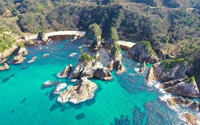
Video Introduction: San'in Kaigan Geopark - A Bird's Eye View of Kami This video, titled "Kami, Hyogo - Drone PR Video (Sea Edit)" (香美町ドローンPR映像(海編)), was uploaded by "Kami, Hyogo - Tourism, Commerce, and Industry Bureau [Official]" (兵庫県香美町 観光商工課). More About the San'in Kaigan Geopark The San'in Kaigan Geopark is recognized as a UNESCO Global Geopark. It refers to a large area of more than 100 km east to west, consisting of San'in Kaigan National Park and the surrounding area, which spans six cities and towns, including Kami, Hyogo in Japan's Kansai Region, Kyotango, Kyoto; Toyooko and Shinonsen in Hyogo, and Tottori City and Iwami in Tottori Prefecture. San'in Kaigan Geopark Trail - Spectacular Views of Precipitous Cliffs Photo:San'in Kaigan Geopark The main feature of the San'in Kaigan Geopark Trail is the sheer cliffs and various landforms along the coastline, as well as the scenery of the Sea of Japan, all of which can be enjoyed via the 27 courses available. ・Yoshioka Onsen - Tottori Station Course: Walk along the banks of lagoons enclosed by sand dunes ・Aotani Station - Tottori City Shikano Socializing and Exchange Hall 'Dream' Course: Walk and feel the eruption of volcanoes and the erosive power of the sea ・Roadside Station Amarube - Yoroi Station Course: Walk in Satoyama with a view of the 41.5-meter-tall Amarube Viaduct Kami, a Small Town in Hyogo, Japan Photo:San'in Kaigan Geopark, Kami, Hyogo In addition to the San'in Kaigan Geopark, Kami, Hyogo, which is located in the San'in Kaigan Geopark, features a variety of other places to visit. For example, Sazu Beach, Imagoura, Okami Park, and the Obikinohana Observatory are all worth seeing. The sunset from Imagoura and the Obikinohana Observatory is truly spectacular! It is also a popular Instagram spot, attracting the attention of a wide range of people, young and old alike. The video shows the beautiful sunset from the Obikinohana Observatory. [Video] 2:22 - The Obikinohana Observatory at sunset Summary of the San'in Kaigan Geopark Photo:San'in Kaigan Geopark The San'in Kaigan Geopark, consisting of six municipalities (Kami, Shinonsen, and Toyooko in Hyogo; Kyotango, Kyoto; Tottori City and Iwami, Tottori), offers a variety of sites and attracts many tourists. Visitors can also observe creatures living on the San'in Coast at the San'in Kaigan Geopark Museum of the Earth and Sea in Tottori Prefecture and the Kami Town Geopark & Marine Cultural Center in Hyogo Prefecture. There's also a sightseeing boat tour in Iwami, Tottori, where visitors can tour the islands of the Uradome Coast and admire the rich natural scenery from a boat. There are many Instagrammable spots where you can take great photos. The San'in Kaigan Geopark is one of the largest geoparks in Japan, spanning Kyoto, Hyogo and Tottori prefectures. There are a total of 27 courses! They are unique coastal trails with both mountain paths and coastlines. There are varying degrees of difficulty as well, so you can choose and plan the course that best suits your individual preferences. 【Official Website】San'in Kaigan Geopark https://sanin-geo.jp/know/en/ 【TripAdvisor】San'in Kaigan Geopark https://www.tripadvisor.com/Attraction_Review-g1022822-d10813685-Reviews-San_in_Kaigan_UNESCO_Global_Geopark-Toyooka_Hyogo_Prefecture_Kinki.html -
 Video article 11:19
Enjoy a Cup of Pure Bliss in the Great Outdoors! Enjoy an Out-of-the-Ordinary Experience With Coffee Brewed From the Spring Water of Oike Spring in Oita Prefecture
Nature- 33 plays
- YouTube
This video, titled "[Hiking] Coffee From a Spring - A Walk in the Woods and a Quiet Time" (【ハイキング】湧き水でコーヒー - 森林散策と静かな時間), was released by "Morinone Channel" (モリノネチャンネル). Wouldn't it be wonderful to make coffee from a clean spring in the mountains and take in the magnificent scenery? The Oike Spring Group in Yufu City, Oita Prefecture, introduced in the video, is an area at the source of the Aso River. The rainfall on Mt. Kurodake is filtered underground over a long period of time to produce clean spring water. It's very comfortable and cool even in summer as it is located 850 meters above sea level. Sitting under a tree, boiling water from the spring with a portable stove, and drinking coffee will refresh your body and mind. -
Video article 3:46
A Cute Baby Squirrel Running Around in the Woods in the Early Morning. The Way It Holds Its Food With Both Hands as It Eats Is Simply Adorable!
Living Things- 721 plays
- YouTube
The Japanese Squirrel This video, titled "A Baby Squirrel in the Forest, Early in the Morning" (子リスの活動、早朝の森の中で), was created by "squirrelstail1." It contains footage of a baby Japanese squirrel in the wild. Squirrels at zoos are especially popular among children. Throughout this video you can see footage of the wild Japanese squirrel. You won't be able to take your eyes off of this adorable critter! Watching the quick and nimble movements of the Japanese squirrel is guaranteed to bring a smile to your face. In this article, we'll introduce the Japanese squirrel, a squirrel native to Japan. Japanese Squirrel Facts Photo:Squirrel The Japanese squirrel is a member of the order Rodentia, family Sciuridae and genus Sciurus (齧歯目リス科リス属, gesshimokurisukarisuzoku), and is more commonly referred to as a rodent (齧歯類, gesshirui). It is called both Nihonrisu (ニホンリス) and Hondorisu (ホンドリス) in Japanese. An adult Japanese squirrel can grow to a height of 16-22 cm with a tail length of 13-17 cm and weight as much as 300g. The underbelly and tip of their tail is white in color and the fur on their body is known to change color depending on the season. Their summer coat is a reddish-brown color whereas their winter coat is more of a grayish-brown color. The Japanese squirrel's call sounds like "kyuukyuu" (キューキュー) in Japanese. You can buy squirrels at pet shops, and other pets, such as chipmunks, can be purchased for around 10,000 yen. They're relatively easy to care for making them a popular small pet. You can buy pellets or seeds to feed your pet squirrel at either a pet shop or home center. Photo:Manchurian walnuts The Japanese squirrel is mostly herbivorous. They like to feed on Manchurian walnuts (オニグルミ, onigurumi) and the seeds and fruits of Japanese larch (カラマツ, karamatsu), Japanese red pine (アカマツ, akamatsu) and Japanese white pine (ゴヨウマツ, goyoumatsu) trees. They are also known to occasionally eat insects and other small animals. They store food in pouches in their cheeks and take it back to their nest where they will then bury and store it underground. From 1:09 and 2:34 in the video, you can see adorable footage of a Japanese squirrel eating food it has found, using both of its tiny hands. Distribution and Habitat of the Japanese Squirrel Source :YouTube screenshot The Japanese squirrel lives in subalpine zones and woodland areas. They are diurnal animals who tend to be very active during the day and rest in the evening. They usually spend most of their time in a set area but may occasionally venture outside of that area to look for food. Japanese squirrels spend most of their time up in the tree tops where they build round nests. From 2:54 in the video, you can see a Japanese squirrel easily climb a tree. Wild Japanese squirrels do not hibernate in winter and have an average life span of 3 to 5 years. Japanese squirrels kept in captivity tend to have a slightly longer life span of around 5 to 7 years. How to Distinguish the Japanese Squirrel From Other Squirrels Photo:Japanese squirrel There are many species of squirrels, such as the Japanese squirrel, Hokkaido squirrel (エゾリス, ezorisu), Taiwanese squirrel (タイワンリス, taiwanrisu), Tamians, and chipmunks (シマリス, shimarisu) and red squirrels (キタリス, kitarisu). They all have their own unique characteristics, but the Japanese squirrel and Taiwanese squirrel are fairly hard to distinguish so we'll describe the differences between the two. The Japanese squirrel has a white border around its eyes which the Taiwanese squirrel doesn't have. In winter, the Japanese squirrel has a tuft of hair at the tip of its ears and a white underbelly; however, the Taiwanese squirrel's underbelly remains the same color as the rest of its body. The Taiwanese squirrel is a non-native species introduced to Japan and are known to be very aggressive in nature. Their increasing numbers, particularly in areas such as Kamakura (鎌倉), are becoming a problem. Summary of the Japanese Squirrel This video shown in this article contains footage of the Japanese squirrel. You won't be able to take your eyes off the cute Japanese squirrel as it plays in the forest early in the morning. If you love animals, be sure to check out the video! -
Video article 3:15
Cute Ezo Red Foxes Playing in Hokkaido. Learn About the Wildlife of Japan!
Living Things- 602 plays
- YouTube
Introducing Hokkaido's Cutest Critters! This video "Parent and child of fox" shows the state of the ezo red fox inhabiting In Hokkaido's, lush wilderness. You can see many wild animals such as raccoons and foxes in Hokkaido's outdoors. Be sure to watch the video to follow along. The Ezo red fox mother curled up with her kit is just adorable! There are many fans of the Ezo red fox in Japan. In 1978, a documentary movie called "The Glacier Fox" was released and became quite popular at the time. In the video, you can see a picture of an Ezo red fox mother with her kit living in nature. It's very soothing scenery. Please enjoy watching it! What Are Ezo Red Foxes? Source :YouTube screenshot Ezo red foxes are an endangered species that are widely distributed throughout Hokkaido and are also calledSakhalin. They have been frequently seen in Aomori Prefecture in recent years. It is a subspecies of the red fox that inhabits various places, and it is a carnivorous mammal. It is slightly larger than the Japanese red fox inhabiting Honshu. Its life span is generally said to be around 10 years. Ezo red foxes make high-pitched calls such as “can-can” and “wan-wan” They often eat rats, birds, and insects as food. And sometimes they come to residential areas in search of food. In this video, the kit stays close to its mother for safety and to play. From 0:06 in the video, they give playful bites and cuddle each other. It is a very cute, relaxing video about 3 minutes long. Where Can I See an Ezo Red? Photo:Ezo red foxes You may want to encounter a wild ezo red fox, but be careful as wild animals can have a parasite called Echinococcus. Kitami City, Hokkaido, has a fox specialty zoo “Ezo Red Fox Ranch”, where you can observe the ecology of cute red foxes in safety. Although it is in Hokkaido, it is quite far from Sapporo City. So if you visit Kitami City, we recommend making a hotel reservation. Summary of Hokkaido's Ezo Red Foxes Photo:Red fox The family of red foxes shown in the video is very adorable. Ezo red foxes live together in the harsh natural environment of Hokkaido. There is also a crepe shop in Fukuoka Prefecture called "Northern Fox's Favorite", which is popular with locals and tourists. Please enjoy the video of Ezo red foxes in Hokkaido; the place with the highest encounter rate of Ezo red foxes, in Japan. -
Video article 2:09
Spectacular view of lush tea fields and Mt! Fuji, Shizuoka Prefecture, a popular photo spot for foreign tourists!
Nature Travel- 576 plays
- YouTube
Fuji, Fuji City, Shizuoka Prefecture, Japan: Tea Fields at the Foot of Mount Fuji, "Obuchi Sasaba" Video Introduction This video, titled “Drone Shot Tea Plantation and Mt. Fuji Obuchi Sasaba(空撮 茶畑と富士山 静岡 大淵笹場 | Tea Plantation and Mt. Fuji),” is a video using drone footage of a tea plantation around Mt. Fuji in Shizuoka in the Tokai region of Japan. It was produced by "crescendo L DESIGN." The Mt.Fuji area in Shizuoka has two famous tea growing locations called Obuchi Sasaba and Imamiya. Early summer, when the lush tea plantation spreads across the slope on the outskirts of Mt. Fuji and shows natural scenic beauty unique to the famous tea growing locations, is the best time to visit. You can watch drone footage of the tea plantation at Obuchi Sasaba in the video. With Mt. Fuji faintly covered in snow in the background, the vast, solid green tea plantation creates a beautiful landscape unique to Japan. Please watch the video and enjoy the scenic beauty that can only be seen in Japan. How Japanese Tea Is Grown Photo:A Tea Plantation Tea plants grow well in warm weather. In Japan, the largest producers of tea are the Mt. Fuji area in Shizuoka, Uji in Kyoto, and Sayama in Saitama, and teas from these area are called the "Three Famous Teas of Japan." An evergreen tree called camellia sinensis is grown in tea farms nationwide and tea picking is held during May when fresh tea leaves are harvested. The tea is harvested and sold as new tea, so be sure to taste the freshly harvested, elegant flavors. In Shizuoka tea plantations, windmill-like structures are installed to protect the new tea from frost damage in the early spring. Obuchi Sasaba in this video is in Shizuoka Prefecture, which boasts the largest tea cultivation and production area in Japan. Experience Tea Picking on the Outskirts of Mt. Fuji! Photo:Tea picking A popular attraction in tea producing areas, including Obuchi Sasaba in the Shizuoka area, is tea picking. There are also spots where you can borrow a tea-girl costume to pick tea and enjoy a memorable experience. Picking tea in the sprawling tea fields of Obuchi Sasaba, is a great way to remember your trip. We recommend that you buy some delicious tea as a souvenir after a leisurely tour of the tea plantations around Mt. Fuji. When is the best time to visit "Oobuchi Sasaba", a tea plantation and Mt. Don't miss the Oobuchi Tea Festival! Photo:The tea plantation of Obuchi Sasaba Shizuoka Prefecture is known as one of Japan's leading tea-producing regions and there are many tea plantations in the prefecture. In spring, you can see the verdant landscape of tea fields at the foot of Mt. Fuji. The scenery has become so popular among foreign tourists in recent years that you can take a tour of the tea plantations by minibus. The best time to photograph the lush tea fields and Mt. Fuji at Oobuchi Sasaba is from late April to May. We recommend the "Oobuchi Tea Festival," which is held during the best time to view the tea fields. The festival is usually held on May 3, and visitors can enjoy a variety of gourmet foods and events, including a photo session where they can take pictures of tea girls picking tea along with Mt. You're sure to get some great Instagram pics! Summary of Obuchi Sasaba In this video, you can see a spectacular view of the greenery of young tea leaves against the backdrop of Mt. Fuji. After viewing the scenic beauty of Obuchi Sasaba, your everyday tea may be more flavorful. We hope you enjoy your early summer sightseeing trip in the scenic beauty of Shizuoka, where you can experience tea picking, buy delicious tea, and enjoy Japanese tea culture! ◆Obuchi Sasaba◆ 【Address】Near 1516, Obuchi, Fuji City, Shizuoka 【Access】About 35 minutes from JR Fuji Station by bus or about 20 minutes from Tomei Fuji IC/New Tomei New Fuji IC by car 【Parking】Toll parking is available near the tea plantation 【Tripadvisor】Obuchi Sasaba https://www.tripadvisor.en/ShowUserReviews-g303147-d10282623-r377490474-Obuchi_Sasaba-Fuji_Shizuoka_Prefecture_Tokai_Chubu.html -
Video article 2:24
The Cute Ezo Momonga - Discover the Flying Squirrels of Japan!
Living Things- 4.5K plays
- YouTube
Japan's Flying Squirrels This introductory video, titled "3 Flying Squirrels" (匹のモモンガ), was created by Shinji Kawamura. It captures footage of three flying squirrels. The Ezo momonga (Ezo flying squirrel), native to Hokkaido, Japan (known in Japanese as "Ezo Momonga," scientific name: Pteromys volans orii) are small mammals who are members of the order Rodentia, family Sciuridae, and subfamily Sciurinae and belong to the tribe Pteromyini. The characteristic feature of the flying squirrel is its gliding membrane which allows it to glide distances of 20 to 50 meters. They are nocturnal animals who are very active at night. They tend to live in small groups, and as you can see in this video, these three flying squirrels live in the same tree burrow. They reach about 15cm in length, small enough to fit in the palm of your hand. They are omnivorous animals, feeding on mainly tree leaf buds, flowers, leaves, bark and seeds. At 0:49 in the video, you can see how they grasp the twigs carefully in their tiny hands and nibble away at the buds. The sight of them grasping the branches with their nimble fingers is adorable! See for yourself! Differences Between the Wild Ezo Momonga and Popular Pet Sugar Glider Photo:Ezo flying squirrel Flying squirrels and Sugar Gliders are similar in appearance but they differ in their scientific classification. Flying Squirrels are members of the Rodentia order, and Sciuridae family, whereas Sugar Gliders are members of the Marsupialia order, and Petauridae family. In other words, flying squirrels are rodents similar to squirrels whereas sugar gliders are marsupials, similar to kangaroos and other animals with a pouch used to carry their young. The sugar gliders you find in most pet stores are friendly and used to being around humans, making them easier to care for than flying squirrels. The cost of buying a sugar glider varies depending on the color of its coat, although a typical brown sugar glider usually costs around 20,000 yen. The average life expectancy of a sugar glider is 5 to 7 years and they feed mostly on fruits, nuts and berries. They communicate through various calls; however, they are relatively quiet animals and easy to look after making them popular as pets in recent years. Differences Between Wild Flying Squirrels and the Japanese Giant Flying Squirrel Photo:Japanese giant flying squirrel Flying squirrels and the Japanese Giant flying squirrel are both members of the Rodentia order, and Sciurinae subfamily and belong to the Pteromyini tribe; however, the Japanese Giant flying squirrel also belongs to the Petaurista genus. In the past they were thought to be of the same species. The Japanese Giant flying squirrel has a larger body than a flying squirrel, roughly double the size. Thanks to its size, the Japanese Giant flying squirrel can also glide significantly further, up to a distance of 100 meters. The Flying Squirrels Native to Japan and the Southern Flying Squirrel The wild flying squirrels of Japan are under threat from the Southern flying squirrel. There is concern over the cross-breeding of Southern flying squirrels and wild Japanese flying squirrels. Southern flying squirrels are an invasive species and the importation of such species is prohibited in order to prevent any damage to the ecosystem of the Japanese flying squirrels. Summary of Japan's Flying Squirrels Source :YouTube screenshot How did you find the video? We hope it helps you understand the difference between the Ezo Momonga and other small, similar-looking mammals. This video gives you a great view of the white, fluffy-coated Ezo Momonga as it plays in the tree tops. I think the footage at 1:06 of them slipping into their tiny tree burrow will bring a smile to your face! Enjoy taking a close look at the wonderful Ezo Momonga, an animal that, because of its small size, is hard to catch a glimpse of in nature! -
Video article 1:28
Sasaguri Kyudai Forest – Like Something You'd See in a Ghibli Movie! Discover One of the Most Scenic Spots in Fukuoka Prefecture, Plus Access Information and More!
Nature Travel- 304 plays
- YouTube
The Bald Cypresses of Sasaguri Kyudai Forest: Video Introduction This video, titled "Giant Conical Trees in a Pond "Bald Cypresses" in Sasaguri, Fukuoka" (view 池に浮かぶ円錐の巨木 福岡県篠栗町の「ラクウショウ」), was uploaded by "SankeiNews." Sasaguri Kyudai Forest is located at the western edge of the Kyushu University Forest in Sasaguri, Fukuoka, in Japan's Kyushu Region. Approximately 50 species of evergreen broad-leaved trees and 40 species of deciduous broad-leaved trees grow in this lush 42-acre forest. The mysterious beauty of the bald cypresses floating on the surface of the water in Sasaguri Kyudai Forest has become a hot topic in Japan, attracting a constant stream of visitors from all across the country. Please take a look at the video below to see the mystical view of Sasaguri Kyudai Forest created by the bald cypresses. [Video] 0:37 - Sasaguri Kyudai Forest An Introduction to Kyushu University Kyushu University, often abbreviated to "Kyudai," is a Japanese university in Fukuoka Prefecture. It is one of the top universities in Japan according to various sources, including the Times Higher Education Japan University Rankings, where it currently ranks 6th. While most courses at Kyushu University are taught in Japanese and will require a JLPT N1 certificate to qualify for, the university also teaches a number of courses in English, and accepts students with an IELTS score of 6.0 or greater. In order to study abroad at Kyushu University, you must be enrolled as a degree student at one of Kyushu University's partner institutions, and be nominated by your home university as a candidate. Kyushu University's graduate school programs have differing requirements in each department, but enrolling in graduate school at Kyushu University requires students pass an entrance exam that is regarded as one of the most difficult in Japan. What is Sasaguri Kyudai Forest? Photo:Sasaguri Kyudai Forest, Sasaguri, Fukuoka Sasaguri Kyudai Forest is located at the western edge of Kyushu University Forest in Sasaguri, Fukuoka, and is jointly managed and operated by Kyushu University and the town of Sasaguri. There is also a walking trail and the area has been open to the public since 2010. The vast 42-acre Sasaguri Kyudai Forest is home to about 50 species of evergreen broad-leaved trees, including itajii and Japanese blue oaks, and around 40 species of deciduous broad-leaved trees, including jolcham oaks and Japanese wax trees. The most eye-catching of all are the giant bald cypress trees. More than a dozen conical trunks can be seen standing in a corner of Kamata Pond. The bald cypress is characterized by its aerial roots. The aerial roots protruding from the ground supply oxygen to the submerged roots. In Japanese, the bald cypress is called "Rakusho" (ラクウショウ), but another name for the tree, which is native to North America, is "numasugi" meaning "swamp cedar." As this name suggests, it prefers places such as swamps and wetlands. The bald cypresses at Sasaguri Kyudai Forest were planted from seedlings in 1977 by Kyushu University to study the tree. The trees are currently around 20 meters tall, but can grow as tall as 40 meters in their natural habitat. The tree's appearance also changes with the seasons, with bright green leaves in the summer and autumn colors in the fall. There's a 2km-long promenade around Kamata Pond in the center of Sasaguri Kyudai Forest, which has been certified as a "forest therapy base" by the Forestry Agency of Japan for its pleasant atmosphere which is great for forest bathing. The Habitat and Characteristics of the Bald Cypress, and How It Differs From the Dawn Redwood Photo:Dawn redwoods The bald cypress is a deciduous coniferous tree of the cypress family (Cupressaceae) native to North America. The name bald cypress comes from their historical tendency to be among the first trees in the American South to lose their leaves in the fall. The bald cypress is characterized by its ability to grow in swampy areas, as evidenced by its other name, "numasugi" (ヌマスギ, lit "swamp cedar"). Another characteristic of the bald cypress, which grows very fast, is that when it becomes an old tree, it grows aerial roots that serve to supply oxygen to its submerged roots. The bald cypress is easily mistaken for the dawn redwood, which has a similar leaf shape, but the difference is obvious when looking at the way the leaves are attached. The bald cypress' leaves are attached to the branches in opposite directions, while the dawn redwood's leaves are attached to the same part of the branch in pairs. [Video] 0:42 - The Roots of the Bald Cypress The Waterfront Forest at Sasaguri Kyudai Forest + the Best Times to See the Bald Cypresses Photo:Bald cypresses at Sasaguri Kyudai Forest, Sasaguri, Fukuoka The 2km-long promenade around Kamata Pond at Sasaguri Kyudai Forest is dotted with attractions, including five plazas. Among them, the Waterfront Forest offers a mysterious view that makes you feel as if you have wandered into the world of Ghibli, and has become a popular spot on Japanese Instagram. This spectacular view can be seen when the water level of Kamata Pond is high. The best time to see the water level rise is from early spring to around the end of Japan's rainy season (June-mid-July). In contrast, the water level is low from summer to fall, but during this period, you can see the aerial roots of the bald cypresses. The best time to see the autumn leaves is mid-November, when the falling leaves decorate the area around the trees in place of the water. Sasaguri Kyudai Forest – Directions and Nearest Station Here is how to get to Sasaguri Kyudai Forest. If you go by train, the nearest station is Kadomatsu Station. Take the JR Fukuhoku Yutaka Line rapid train bound for Nogata at Hakata Station (platform 8), get off at Kadomatsu Station, and take a taxi to the Sasaguri Kyudai Forest south exit parking lot (篠栗九大の森南口駐車場, Sasaguri Kyudai no Mori Minami-guchi Chushajo), which takes about 10 minutes. The train ride from Hakata Station takes about 17 minutes, or 4 stops if you take the rapid train. The fare is 280 yen. If you take a bus, the nearest station is Kasuya Police Station. Take a highway bus bound for "Iizuka/Tagawa" from Tenjin Expressway BT bus stop #1 and get off at "Kasuya Keisatsu Sho-mae" (粕谷警察署前). Go straight for about 300m east on the sidewalk with the bus stop, turn left and keep going straight until you see the information board for "Sasaguri Kyudai Forest", follow the sign and you will arrive at Sasaguri Kyudai Forest in about 15 minutes on foot from "Kasuya Keisatsu Sho-mae". The bus ride from Tenjin to "Kasuya Keisatsu Sho-mae" takes about 35 minutes and costs 510 yen. If you're going by car, the shortest route to the waterfront forest is via the "North Exit Parking Lot." Directions are as follows: Exit the expressway at the "Fukuoka IC" and go straight for about 2 km in the direction of Iizuka (飯塚). Then turn left at the "Wadabashi Signal," go about 50m, turn left again, go straight for about 300m, then turn right and go uphill. Continue straight and you will arrive at the South Exit Parking Lot of Sasaguri Kyudai Forest. Go straight for about 200m from the South Exit Parking Lot, then turn right and walk about 300m through the forest to reach the North Exit Parking Lot. Although you can get there by car, we recommend using public transportation to avoid traffic congestion caused by the increase in the number of tourists to Sasaguri Kyudai Forest. Summary of the Bald Cypresess of Sasaguri Kyudai Forest Sasaguri Kyudai Forest is a photogenic spot that is rapidly gaining popularity. However, it's become so popular that many tourists visit the forest. As a result, the forest is experiencing problems, such as traffic congestion, and destruction of the forest due to violations of etiquette, such as barbecuing, littering, and taking photos in restricted areas. They've even considered closing the area to allow the forest to recover.... To prevent this from happening, please follow the rules and manners, and enjoy the cypresses of Sasaguri Kyudai Forest, one of the best healing spaces in Fukuoka. [TripAdvisor] Sasaguri Kyudai Forest -
Video article 7:32
The Graceful Sight of the World-Famous Mount Fuji Can Be Enjoyed From All Over Japan. This Article Will Help You Find a Spot to View Mt. Fuji That’s Just Right for You!
Nature Travel- 246 plays
- YouTube
Introducing the Places to View Mt. Fuji This video, titled "JG☆☆☆☆☆4K Mt.Fuji View Spots You can’t afford to miss" (JG☆☆☆☆☆4K 一度は訪れたい 富士山の絶景ポイント Mt.Fuji View Spots You can't miss) introduces many view spots and tourism spots where you can enjoy the magical scenery of Mount Fuji. Mount Fuji is the tallest mountain in Japan with a height of 3,776 meters above sea level and has been recognized as a World Cultural Heritage site, one of Japan’s Three Great Mountains, and one of Japan’s 100 Finest Soils. As is introduced in the video, you can also observe its grandeur from faraway in the Tokai Region (東海地方,Tokai-chiho) and Kanto Region (関東地方,Kanto Chiho), so why not go out and enjoy the scenery? If you can't go out though, don't worry. We've got you covered with this article. Enjoy the sight of Mount Fuji from various places in Japan through this video. Check out the Best Places to View Mt. Fuji! ©Koichi_Hayakawa Modifying The view of Mount Fuji from Osatsu (相差), Toba City, Mie Prefecture is one location introduced at the beginning of the video. The contrast between the five-storied pagoda of Arakura Fujisengen Shrine and Mount Fuji, which can be seen at 0:22 in the video, is exquisite. This magnificent view is currently the most famous Japanese scenery among foreigners. Many foreign tourists come to Japan to enjoy this view. It truly is the apex of nature. As you can see in the video, there are many popular viewing locations around Mount Fuji such as Lake Kawaguchi (Video 0:49〜), Lake Shoji (Video 1:15〜), Lake Yamanaka (Video 1:23〜), and Oshino Hakkai (Video 1:55〜). The views of Mount Fuji from the Kariyado-Geba Cherry Blossom Tree and Lake Tanuki in Fujinomiya City, Shizuoka Prefecture, are also breathtaking. You can see Mount Fuji up close from Satta Pass (薩埵峠,Satta-toge) in Shimizu Ward, Shizuoka Prefecture and from Miho no Matsubara (三保の松原,Mihonomatsubara), one of Japan’s Three Great Sceneries, as you can see from 3:05 in the video. Fujieda Takizawa: Mount Fuji Over Shizuoka’s Famous Tea Fields! Photo:Night view from Otome Pass Gotenba (Video 3:40〜), Numazu Area (Video 3:54〜), Yamanaka Castle(Video 4:45〜) and Nagahama Castle (Video 4:58〜) are historic places where you can enjoy the beautiful view of Mount Fuji. As you can see in the video, the night view around the foot of Mount Fuji and the view of Mount Fuji from across the sea are nothing less than breathtaking. Ose (Video 5:12〜), Heda Sea (Video 6:04〜), the canola flower fields of Ida (Video 5:58〜), Mount Daruma in Izu City, and Mount Takichi which you can observe from 6:23 in the video are also places where you can view Mount Fuji. At 6:34 in the video, you can see the sight of Mount Fuji from Kyonan Town, Chiba Prefecture, a faraway place. Mount Fuji, which stands in the endless sea with a hat of snow, is said to be the winter scenery that represents Japan. It’s exciting when you can see Mount Fuji from the window of your car or when riding a bus. From 7:08, you can see Mount Fuji from the window of a car on the express lane, a bullet train, and an airplane. At the end of the video at 7:28, you can see a gorgeous view of the contrast between the bright yellow canola flowers and Mount Fuji. The snow around the peak of Mount Fuji is beginning to melt, signaling the arrival of spring. Climbing and Tourist Information About Mount Fuji! Photo:Mount Fuji Many people visit Yamanashi prefecture and Shizuoka prefecture once mountaineering season has started in order to enjoy mountain climbing/hiking or walking around the crater. Please thoroughly check the route and distance to the mountain hut and the camping area, the weather forecast, the time it will take, and information about eruptions before mountaineering. It is also crucial that you check the live camera at the fifth station of Mount Fuji, carry a map, and wear clothes that you can move easily in. You can arrive at the fifth station of Mount Fuji by car, using the Fuji Subaru Line or the Mount Fuji Sky Line. A parking lot is also provided. The mountain paths are Yoshida, Gotenba, Fujinomiya, and the Subashiri Route, but be careful because some of them are closed depending on the season. If you’re going to visit Mount Fuji, be sure to visit the Mount Fuji World Cultural Heritage Center and Kodomo no Kuni! Summary Photo:Mount Fuji and cherry blossoms As is introduced in the video, there are countless spots around Mount Fuji where you can enjoy the graceful scenery of the mountain that it has been revered for. When you visit Mount Fuji, it is important to follow rules, behave respectfully, and avoid trouble. Set out on an adventure to these viewing locations in Shizuoka and Yamanashi prefecture after careful and deliberate preparation. Please enjoy the sight of Mount Fuji, the mountain that shows us different faces depending on the location and season. It is the pride of Japan. 【Official Website】Mount Fuji NET | Information about Mount Fuji https://www.fujisan-net.jp/ 【Tripadvisor】Mount Fuji https://www.tripadvisor.com/Attraction_Review-g298102-d321024-Reviews-Mount_Fuji-Chubu.html -
Video article 2:55
The Japanese Green Pheasant: The National Bird of Japan, Its Majestic Silhouette and Bright Red Wattle Are Fascinating!
Living Things- 605 plays
- YouTube
The Wild Japanese Green Pheasant "A Family of Pheasants" (キジの一家), created by "Nyanta8355," is a video of a family of Japanese green pheasants, the national bird of Japan. Japanese green pheasants have a distinctive red wattle and its beauty catches the attention of all that see it. It has a mysterious charm, and it is even believed that they can predict earthquakes. Japanese green pheasants are a familiar species to Japanese people, as they're in the famous Japanese folk tale Momotaro (桃太郎). The video shows footage of them in the wild. The article will also introduce the Japanese pheasant, so be sure to follow along with the video as you read on! The Japanese Green Pheasants Photo:Japanese green pheasants Japanese green pheasants (Order: Galliformes, Family: Phasianidae, Genus: Phasianus) that you see in the video, are quite common in Japan, and Japanese people are very familiar with them. At the start of the video, we see a male Japanese green pheasant, which has a distinctive red wattle and colorful plumage, then at 1:38, we see a female Japanese green pheasant. As you can tell by the footage, female Japanese green pheasants are not as colorful as male Japanese green pheasants. The Japanese pheasant is the symbolic bird of Japan and has a majestic appearance befitting of the national bird. In many municipalities, the pheasant has been designated as the town bird. As mentioned earlier, the Japanese pheasant is well-known in Japan, as it was one of the characters, along with the dog and monkey, in the Japanese folk tale, Momotaro. You can also see the bird on the front of the old 10,000 yen bill, which is another reason Japanese people are so familiar with the bird. As for the size and shape of the Japanese pheasant, the overall length of the male is about 80 cm and the female is about 60 cm. Male Japanese green pheasants weigh about 0.8 to 1.1 kilograms. Males weigh between 0.8 and 1.1 kilograms and females between 0.6 and 0.9 kilograms. Ring-necked pheasants, which are widely distributed in Eurasia, are slightly larger than Japanese green pheasants. Photo:Japanese green pheasants Male Japanese green pheasants have a red wattle around the eyes, while females have brownish colored plumage. During mating season, the red wattle on a male Japanese green pheasant swells, lets out loud mating calls. Japanese pheasants make loud cries during territorial disputes. Japanese pheasants are also very wary and will often dash away if they are noticed. They also live quietly and are not very active outside of spring, so if you want to observe them, spring is the best time to do so. Japanese green pheasants mainly feed on seeds, sprouts, and leaves. In Japan, many pheasants are released in bird sanctuaries, fallow hunting areas and additive hunting areas. This takes place every year during birdwatching week and before the hunting season. The Various Types of Pheasants Photo:Japanese green pheasants Some people believe that the Japanese pheasant, an endemic species in Japan, is a subspecies of Ring-necked pheasants found in Eurasia, and the Ornithological Society of Japan and others have adopted this theory. Japanese pheasants and ring-necked pheasants are game birds, and pheasant meat is eaten for food. There are four main subspecies of pheasant distributed in Japan: The Kyushuu pheasant (kyushukiji, キュウシュウキジ) is found in southwestern Honshu, Kyushu and the Goto Islands; the northern pheasant (kitakiji, キタキジ) inhabits northern Honshu and Sado Island; the Island pheasant (shimakiji, シマキジ) inhabits Honshu, Tanegashima, Izu Oshima, Yakushima and Niijima; and the Tokai pheasant (toukaikiji,トウカイキジ) is found in central Honshu and Shikoku. Pheasants are mainly found in grasslands, rural areas, forests and flatlands, and sometimes appear in urban areas, causing damage to agriculture and other areas. Summary of the National Bird of Japan Source of photo :YouTube screenshot The video, "A Family of Pheasants," created by "Nyanta8355," shows footage of the Japanese green pheasant, the national bird of Japan! In the video, you can see the majestic Japanese pheasant in its natural habitat. The appearance of female and male pheasants is completely different, so be sure to check them out. In Japan, a cat with a pheasant pattern is called a pheasant cat! From being designated as Japan's national bird to their supposed ability to sense earthquakes, the Japanese pheasant is a fascinating animal! -
Video article 2:56
Is This Place Really in Japan??? Kouri Island in Okinawa Is a Southern Island Paradise Surrounded by Emerald Green Seas!
Travel- 351 plays
- YouTube
Introducing Kouri Island This video, produced by “Noriyuki Ichikawa,” is titled “[Aerial Footage] A stunning view of Okinawa. The beautiful turquoise of Kouri Island"(【空撮】沖縄の絶景・古宇利島・美しいターコイズブルー Okinawa Aerial Shoot). The aerial footage allows us to fully appreciate the spectacular landscape and blue seas of Okinawa's Kouri Island. This video is less than 3 minutes long, so if you want to enjoy the beautiful natural scenery and learn about the attractions in the area, as well as tourist information about Okinawa, take a second to check it out! Enjoy the beauty of Kouri Island, one of Japan's most famous power spots. About Kouri Island Photo:Kouri Bridge Kouri Island is located in Nakijin, Kunigami district, Okinawa, and is praised as having the most beautiful waters in Okinawa. Although it is a remote island, it can be easily accessed via Yagaji Island (屋我地島, Yagajishima) from the the 2,020 meter long Kouri Bridge connecting Yagaji Island and mainland Okinawa. The Kouri Bridge can be seen from the beginning of the video. Enjoy visiting Kouri Island, a remote island only about 90 kilometres from Okinawa Naha Airport. Allow the beautiful, soothing, turquoise blue sea to caress your body. Enjoy Activities in the Beautiful Turquoise Sea! Photo:Marine Sports With its year-round warm weather, Kouri Island is a great place to enjoy Okinawa's unique activities. Enjoying marine sports, such as swimming and snorkeling in the emerald green waters, is hard to beat. You can see some impressive windsurfing on the beautiful turquoise waves at 2:01 in the video. We also recommend stopping by Heart Rock and Ocean Tower, to see some beautiful waves. Don't forget to take some photos for your Instagram! Kouri Island also offers a wide range of accommodations, so you can stay overnight and enjoy a full day of activities while forgetting about the passing of time. Tasty Okinawan Food; Essential to Any Trip to Okinawa! Photo:Sea urchin bowl After sightseeing on Kouri Island, enjoy Okinawan cuisine at one of the cafes or other eateries along the beach. At the Kouri Island Fureai Square near the Kouri Bridge, you can enjoy Okinawan cuisine with plenty of fresh seafood. The fresh sea urchin rice bowl served with a seaside view is superb. There is a large parking lot at the Kouri Island Fureai Hiroba (market), so even if you rent a car, you can visit the island with ease. Summary of Kouri Island in Okinawa Kouri Island is accessible from Naha Airport in 1 hour and 30 minutes via the Okinawa Expressway or 2 hours by public highway. The video of the crystal-clear, turquoise seas, that are hard to believe are in Japan, will leave you wanting more. Enjoy the soothing turquoise waves of Kouri Island! 【Official Website】Kouri Island / KOURIJIMA ~a bridge-connected remote island in Nakijinson in Okinawa http://kourijima.info/ -
Video article 2:53
Is Tojinbo in Sakai City, Fukui Prefecture, a sacred place for suspense drama fans? The power spot on the precipitous cliff with a spectacular view is a thrilling experience!
Nature Travel- 177 plays
- YouTube
Tojinbo" in Sakai City, Fukui Prefecture Video Introduction Tojinbo, in Fukui prefecture, located in Japan's Hokuriku region, is a series of vertical cliffs created by the rough waves of the Japan Sea. It is a rare type of sea cliff which can only been seen in 3 other places in the world. This video, titled "(4K) Aerial Drone Footage / Flown in Tojinbo in Sakai City, Fukui Prefecture" (【4K】福井県坂井市 東尋坊で飛ばしてみた / ドローン空撮), was produced by "Mattsu." The video shows the exposed rock face and jagged landscape of Tojinbo via aerial drone footage. The geological composition of the cliffs of Tojinbo is made up of pyroxene andesite and some of the cliffs tallest points are approximately 25m tall. Its strangely shaped pillars extend for 1km and it has been designated a Natural National Monument and Scenic Spot, and is also a part of the specially protected area of Echizen-Kaga Kaigan Quasi-National Park. It is also one of the world's 3 most geologically rare scenic spots, and therefore it is well known around the world. The origin of the name Tojinbo is said to have come from the name of a monk "Tojinbo" who lived long ago and was affiliated with Heisenji Temple and lost his life after being thrown off the cliff in a romantic tangle. After Tojinbo was thrown into the sea; another monk, his rival in love, was also pulled into the rough waves and tempestuous weather continued for 49 days. Or so the legend goes anyways... It is also famous for being used as a film location for climactic scenes in which the culprit tries to throw him or herself into the sea after making a confession in suspenseful TV dramas or movies. Tourist Attractions Around Tojinbo Photo:Tojinbo, Fukui Prefecture The Tojinbo cliffs, which is a rare rock formation even outside of Japan, is a famous place that even many Japanese would like to visit at least once. In order to preserve Tojinbo's amazing view there are no safety features such as fences installed there. You are able to walk around Tojinbo freely, however, please watch your step. The recommended tourist sites around Tojinbo are, Tojinbo Tower, Echizen Matsushima Aquarium, the caravan campsite Kyukamura Echizen Mikuni, Echizen Matsushima, Minato-machi Mikuni, Shibamasa World, and the Araiso Shoreline Esplanade. Also, if you take the Tojinbo/Oshima sightseeing boat tour, you will be able to see the cliff face from the ocean and will be able to enjoy all of the Instagrammable locations such as Lion Rock and Candle Rock. In addition, the Mikuni Fireworks Festival is held near Tojinbo in the summer and every year many tourists flock to see this event. Tojinbo's Famous Hot Springs and Gourmet Food! Photo:A crab dish When you the town Mikuni, in Sakai city, Fukui prefecture, that Tojinbo is in, try to stay at the Mikuni Kanko Hotel. Japan's Hokuriku region is famous for Echizen crab and the crab dishes made from Fukui's freshly caught crab are absolutely delectable! You should also definitely go to the nationally famous, Mikuni hot springs. Relax and rid yourself of stress by sightseeing in Tojinbo, eating delicious seafood and relaxing in the hot springs- All at the Mikuni Kanko Hotel. Summary of Tojinbo in Fukui Prefecture Source :YouTube screenshot One of the world's most beautiful sights! Directions (access by public transportation such as bus), parking, events and other information about Tojinbo in Fukui prefecture, can be seen on the Mikuni hot springs official website "Mikuni Marugoto Navi." Now that you've seen the beautifully taken drone footage, it’s time to see it in person! Tojinbo|Sakai City Tourist Spots|Sakai Tabinavi, the official tourism guide to Sakai City, Fukui Prefecture https://kanko-sakai.com/spot/k001/ 【Tripadvisor】Tojinbo https://www.tripadvisor.com/Attraction_Review-g1021160-d1385002-Reviews-Tojimbo_Cliff-Sakai_Fukui_Prefecture_Hokuriku_Chubu.html -
Video article 2:48
The Beautiful Ogawa Falls in Kagoshima Prefecture's Kimotsuki District. The Emerald Green, Crystal Clear Waters Are Truly Captivating! So Beautiful It Was Even Used for One of NHK's Long Running Dramas!
Travel Nature- 343 plays
- YouTube
More About the Dynamic Ogawa Falls of Kagoshima Prefecture This video, titled "(4K) Drone Aerial Photography "Ogawa Falls" Minami Osumi (南大隅町, minamioosumimachi), Kimotsuki district (肝属郡, kimotsukigun), Kagoshima prefecture" filmed by drone, was created by Studio Kama. Ogawa Falls is a beautiful waterfall located in south-eastern Kagoshima prefecture in an area called Nejime on the Osumi peninsula. It's approximately 60 meters wide with a drop of 46 meters. If you're looking to enjoy sightseeing in Japan, we highly recommend the beautiful, dynamic scenery of Ogawa Falls. In this video you can take a look at the picturesque scenery of the crystal clear river and the flowing waterfall. You're sure to be captivated by its beauty. Ogawa Falls Was the Filming Location for a Famous Japanese Drama! Photo:Ogawa Falls Ogawa Falls is a beautiful waterfall in Minami Osumi, Kimotsuki district in Kagoshima prefecture. The opening scenes for the Japanese drama "Segodon," released in 2018, were shot at Ogawa Falls, leading to a huge increase in popularity. Ogawa Falls was also used as a filming location for the 2019 movie "Kingdom." Many fans have been known known to visit Kagoshima to see these film locations as well as many visitors on pilgrimages. Enjoy Hiking to Ogawa Falls The walk from the tourist parking area to Ogawa Falls is approximately 1200 meters. You can access the parking area by bus or car and then enjoy walking the invigorating trekking route to Ogawa Falls that takes past mountain streams and is surrounded by nature. If you plan to go to Ogawa Falls for sightseeing, we recommend stopping by Aqua Base Café, which can be found just before arriving at the trekking route parking area. Why not buy a drink and enjoy the much talked about scenery from the café, overlooking the basin of the waterfall. It's the perfect spot to take photos to share on Instagram! You can take a look at the area surrounding the waterfall at 0:59 in the video. More of the Amazing Features of Ogawa Falls Source :YouTube screenshot There are many tourists who visit the dynamic Ogawa Falls to experience the healing effects of the negative ions. Here you can enjoy your time relaxing whilst looking out onto the emerald green waters of the waterfall basin and sparkling waters of the waterfall. The highlight of this video has to be in the second half of the video at 02:11, where you can catch a beautiful panoramic view of Ogawa Falls. We highly recommend stopping by the observation deck found upstream of Ogawa Falls. There generally tends to be less people here making it a relaxing spot to enjoy the scenery of the waterfall and towering gorge. Summary of Kagoshima Prefecture's Ogawa Falls The beautiful and fascinating Ogawa Falls is gaining popularity as a tourist destination in Kagoshima prefecture. The scenery of the emerald green waters of the waterfall basin seen in this video, is a sight you're sure not to forget. Be sure to take a look at the wonderful scenery in the video! We highly recommend a trip to Ogawa Falls in Kagoshima prefecture to anyone who wants to make the most of their trip to Japan! ◆Ogawa waterfall◆ 【Address】Nejime Kawakita 12222, Minami Osumi, Kagoshima prefecture 【Access】Around a 1 hour 45 minute drive from Kagoshima airport (鹿児島空港, kagoshimakuukou) 【Admission Fee】Free of charge 【Hours】No entry during evening hours 【Closures】None 【Parking】Available 【Phone number】0994-24-3115 (Minami Osumi Town Hall Tourist Section) 【Tripadvisor】Ogawa Falls https://www.tripadvisor.com/Attraction_Review-g1121596-d4564546-Reviews-Ogawano_Taki_Falls-Minamiosumi_cho_Kimotsuki_gun_Kagoshima_Prefecture_Kyushu.html 【Tripadvisor】Minami Osumi https://www.tripadvisor.com/Tourism-g1121596-Minamiosumi_cho_Kimotsuki_gun_Kagoshima_Prefecture_Kyushu-Vacations.html -
Video article 2:24
The Encounter of Waves, Brought Together by Two Islands, Is Reminiscent of Long Lost Lovers Being Reunited. Come Check Out the Amazing Scenery at Lover’s Cape in Wakayama Prefecture!
Nature Travel- 337 plays
- YouTube
The Gorgeous "Lover’s Cape" in Wakayama Prefecture! This video, titled "Lover's Cape - Wakayama - 恋人岬," introduces Lover’s Cape, a famous tourist spot in Susami, Wakayama prefecture in Japan's Kansai region. Lover's cape is also included in the "8 Scenic Views of Susami." The fierce waves split after hitting Kuroshima, and the shape and action of the 2 waves hitting each other again is said to be similar to putting one’s hands together in pray, thus, the waves are called "Gassho Nami" (合掌, Gassho, "Putting one's hands together in prayer, 波, Nami "Wave"). You can see the waves coming together at 0:48 in the video. The mysterious waves are called "Meotonami" (夫婦波, Wedded Waves) and the towering rocks are called "Meoto Iwa" (夫婦岩, Wedded Rocks) and has been selected as one of the "66 Waterfront Areas to Be Cherished in Wakayama" for its beautiful view. Because of its romantic name and scenery, it is popular with couples, and as the name "Lover's Cape" implies, many couples visit here. Lover’s Cape, a Popular Tourist Spot in Wakayama Prefecture Source :YouTube screenshot Lover’s Cape, introduced in the video, has 2 main attractions. The first is a cave called "Gama," located on the west side of Kuroshima. Here, you can enjoy scuba diving from March to the end of April and from late June to the end of October. Historically, there is a legend that it contains hidden treasures of the Kumano navy, and many people visit during scuba diving season. The second attraction at Lover's Cape is that between October and January and between April and September, the slopes of Lover's Cape are covered with bougainvillea flowers. You can also enjoy fishing here as well. Lover’s Cape is A 15-minute walk from Mirozu Station or a 15-minute drive from the Susami Interchange on the Kisei Expressway. Free parking is also available, so be sure to take advantage of it if you're going by car. The Waves of Lover's Cape Photo:Wakayama prefecture・Meotonami Lover's Cape consists of two islands one with a large reef and the other with a small reef. The islands are called Oki-no-Kuroshima and Riku-no-Kuroshima respectively. The Karekinada coastline, which was formed by upheaval and erosion of the Kii Peninsula, is famous for the phenomenon known as "Tombolo," where a road is formed between the two islands, and you can enjoy the dynamic ocean with waves on both sides. The entire island of Esuzaki Island in Wakayama Prefecture, where Lover's Cape is located, is a sacred area, and Kuroshima Benzaiten (a Buddhist goddess) is located at the bottom of the cliff at Lover's Cape. The bright red torii gate can be seen at 1:48 in the video as well. The view from Lover’s Cape in Wakayama prefecture Photo:Susami・Sunset from Roadside Station Susami The sunset that can be seen from Lover’s Cape is so gorgeous that it was chosen as one of the Top 100 Sunrise / Sunset Views of Wakayama Prefecture, and many tourists travel to see it. Being that "Meotonami" was selected as one of the "8 Scenic Views of Susami," it's a great place to quietly spend time gazing at the sunset and waves. There is also a restaurant at Lover's Cape called Italian Café BUSH. The interior of the restaurant is modeled in a Mediterranean style and you can enjoy pastas or pizza made with local ingredients. Their business hours are 9:00-18:00 so you can appreciate Wakayama prefecture’s sunset while enjoying a delicious meal at the restaurant. Lover’s Capes Around the World Photo:Izu・Lover's Cape Bell In addition to Lover's Cape in Wakayama Prefecture, there are many other Lover's Capes around the world. At Lover's Cape in Izu City, Shizuoka Prefecture, there's a story about a man who rang a bell when he passed through the cape, and it is said that if you call out the name of your beloved while ringing the bell, your love will be fulfilled. Lover's Cape in Guam is a spot where you can enjoy a spectacular panoramic view of Tumon Bay, which is depicted on the national flag of Guam. It's called "Lover's Cape" because of a story about a couple who pledged their eternal love to each other and jumped into the sea. The Lover’s Cape in Kashiwazaki in Niigata prefecture, is located at the Nihonkai Fisherman’s Cape, and it is a place where you can ring a bell with a heart-shaped plate for good romantic fortune. Summary of Lover’s Cape Source :YouTube screenshot What did you think about Lover's Cape? Lover’s Peak is definitely a place to go to when sightseeing in Wakayama. It has incredible views of nature romantic sunsets as well. Be sure to bring your lover with you when you visit! 【Official Website】Lover’s Cape – Izu City Tourist Information dedicated website http://kanko.city.izu.shizuoka.jp/form1.html?pid=2528 【Trip Advisor】Lover’s Cape https://www.tripadvisor.com/Attraction_Review-g1121354-d8538044-Reviews-Lover_s_Cape-Susami_cho_Nishimuro_gun_Wakayama_Prefecture_Kinki.html -
Video article 3:56
Lake Ozenuma Summer Hiking! Trek Through the Beautiful Daylilies of Lake Ozenuma, a Famous Place for Flowers at Oze National Park in Fukushima, Japan!
Nature Travel- 83 plays
- YouTube
The Daylilies of the Oe wetlands at Lake Ozenuma: Video Introduction This video, titled "Lake Ozenuma in Summer and Hiking Through the Daylilies of Oe Marsh|Daylilies at Lake Ozenuma|A Famous Place for Flowers" (夏の尾瀬沼とニッコウキスゲの大江湿原ハイキング 尾瀬沼のカンゾウ 花の名所 花見頃), was uploaded by "Discover Nippon." Daylilies are a common seasonal flower during summer in Japan, and Oe Marsh is famous for its spectacular view of the flowers. [Video] 0:21 - Oe Marsh The video shows the yellow daylilies swaying in the summer breeze and the beautiful scenery of various highland plants surrounding the marshland and Lake Ozenuma. Be sure to enjoy the beautiful video showing the lush greenery and brilliantly blooming flowers in this 4-minute video. [Video] 0:28 - Highland Plants [Video] 2:07 - Daylilies Oe Marsh – A Popular Attraction at Oze National Park Photo:Daylilies at Oe Marsh Oze National Park is a famous landmark in Japan and is home to Oe Marsh, an attraction known for its beautiful flowers. Oe Marsh lies around the Oe River near the village of Hinoemata, Fukushima and is known for the beautiful daylilies that bloom there. If you go down river, you'll find Lake Ozenuma, which is surrounded by a promenade for visitors to enjoy a relaxing stroll around it. It's an especially popular attraction during the summer months. What Are Daylilies? Facts and Interesting Information About the Famous Flower of Oze National Park Photo:Daylilies The daylilies of Oze National Park are characterized by their dark orange-yellow petals, of which it has six. The best time to see the daylilies at Oze National Park is from late June to August, as they grow at high elevations in the mountains, where temperatures can vary greatly. In Japanese, the daylilies at Oze National Park are called Nikkokisuge (ニッコウキスゲ, 'Nikko Daylilies'), which comes from the fact that there are many colonies of them that can be found growing in Nikko, Tochigi. Other than Oe Marsh, these daylilies can be found at Senjogahara Marshland and in the Kirifuri Highlands of Nikko, Tochigi, where the name originated, as well as in Nagano Prefecture, which is home to the Kirigamine Highlands and Kurumayama Highlands, where the flowers can be found growing in colonies. What makes the flowers so special is the vivid color of their petals. The flower is known to bloom in the morning and close in the evening, and it's almost as if it puts all of its energy into blooming to show you its brilliant beauty. Other Flowers to See at Oe Marsh, a Famous Spot for Flowers in Oze National Park! Photo:Daylilies at Oe Marsh Oe Marsh in Fukushima Prefecture is one of the most famous flower viewing spots in Oze National Park. Oe Marshland is famous for its flowers in summer, but there's a lot more to see than daylilies. Here we'll introduce the best time to view the different flowers around the Oe River from spring to summer, together with the meanings of each flower in Japanese culture. Daylilies A short-lived flower that blooms in the morning and withers in the evening. The bright color of the flower is its distinguishing feature. Best time to see it: Mid-July to late July Language of Flowers: Something new each day Photo:Skunk cabbage Skunk Cabbage At first glance, skunk cabbage looks like a large white flower, but the white part is actually not a petal, but rather a type of leaf called a bract. The white leaves have a strong presence, and the stick-like part of the leaf is surrounded by a flower that looks like an ear. It's popular for its dignified appearance. Best time to see it: Mid-May to early June Language of Flowers: Beautiful memories Photo:Cottongrass at Lake Ozenuma Hare's-Tail Cottongrass In June, small yellow petals bloom from this flower, and by the end of June, they turn into fluffy, white, round heads. The lovely cotton grass blooms all over Oze National Park. Best time to see it: Late June to mid-July Language of Flowers: Wavering thoughts ※The above information is based on the usual flower viewing times for Oze National Park as a whole. The blooming time and best time to see the flowers may vary with the climate of a given year and the altitude of the area the flower is growing, so please view this information only as a reference, not as a guarantee. Let's Go Hiking in Oze – Lake Ozenuma to Oe Marsh: A Walking Course Recommendation for Enjoying the Splendid Scenery of Oze National Park Photo:Lake Ozenuma hiking trails Oze National Park, which boasts a vast area, has a number of hiking courses, some of which are quite advanced and will require an overnight stay at a mountain lodge. We recommend a one-day course that begins at Numayama Pass on the Fukushima Prefecture side of the mountain, passes through Oe Marsh, and returns to Numayama Pass after stopping at Lake Ozenuma. It's a 4.35-mile hike, and the wooden boardwalk is well maintained, making it ideal for hiking beginners and those who want to enjoy a casual hike to see the views in Oze National Park. Oze National Park Day Trip Hiking Course Numayama Pass → Oe Marsh → Lake Ozenuma → Oe Marsh → Numayama Pass Near Lake Ozenuma, there is a famous photo spot as well as the Ozenuma Visitor Center where you can get information about the nature of Lake Ozenuma and Oze National Park by experts on the area. How to Get to Oze National Park From Tokyo How you decide to travel to Oze National Park will depend on which hiking course you plan on using. For the hiking course we listed above, the best way to reach Numayama Pass is as follows. Take the train from Tokyo Station to Aizukogen-Ozeguchi Station (210 mins), then take a bus to Numayama Pass (120 mins). This route will take about 6 hours in total and there will be a couple transfers depending on the line you use. Most trains will take you to Kitasenju Station and from there will be a straight shot to Aizukogen-Ozeguchi Station via the Tobu Line's Limited Express Revaty. Oze National Park From Tokyo Station Tokyo Station → Aizukogen-Ozeguchi Station → Numayama Pass ※The bus from Aizukogen-Ozeguchi Station to Numayama Pass is not in operation from November to March. ※Oike to Numayama Pass is closed from November to mid-May. If you're hiking at a trail starting at Hatomachi Pass or Oshimizu, you can use one of the two following routes. Take the shinkansen from Tokyo station to Jomo Kogen Station (60 mins), and from there take a bus to Togura (戸倉) (120 mins), and from Togura, take a bus to Hatomachi Pass (25 mins). Tokyo Station → Kogen Station → Togura → Hatomachi Pass ※The bus from Togura to Hatomachi Pass is not in operation from November to April. Take the shinkansen from Tokyo station to Jomo Kogen Station (60 mins), and from there take a bus to Togura (戸倉) (120 mins), and from Togura, take a bus to Oshimizu (20 mins). Tokyo Station → Kogen Station → Togura → Oshimizu ※The bus from Togura to Oshimizu is not in operation from November to April. Summary of Summer at Lake Ozenuma and Oe Marsh Currently, there are more than 900 species of alpine plants that inhabit Oze National Park, making it a very unique place to visit in Japan. In order to protect the scenery of Oze National Park, we ask that you please do not leave trash behind or step foot into the wetland area. In the summer, vast mountains and lovely flowers await you in Oze National Park. Whether you're a serious climber or visiting for a casual nature walk, be sure to stop visit! 【TripAdvisor】Oe Marsh -
Video article 2:19
Mt. Sobo - Easy Mountain Climbing and Hiking Courses Through Valleys and Lush Virgin Forests! Famous Peaks and Breathtaking Views in Oita and Miyazaki Prefectures!
Travel Things to Do Nature- 46 plays
- YouTube
Mt. Sobo Video Introduction This video, titled "Kobara Gorge [Gorge Walking Video] Sobo, Katamuki and Okue Biosphere Reserve" (神原渓谷【渓谷散策動画】祖母・傾・大崩ユネスコエコパーク), was uploaded by "Sobo, Katamuki and Okue Biosphere Reserve" (祖母・傾・大崩ユネスコエコパーク). Mt. Sobo, one of the 100 Famous Japanese Mountains, is the source of Kobara Gorge. Designated as Sobo-Katamuki Quasi-National Park, visitors can enjoy the beauty of the fresh greenery in summer and colorful autumn leaves in fall while enjoying a relaxing hiking experience. The Sobo, Katamuki and Okue Biosphere Reserve – Tons of Popular Tourist Attractions Photo:Takachiho Gorge Straddling Oita and Miyazaki prefectures, the area surrounding Mt. Sobo, Mt. Katamuki, and Mt. Okue is home to lush virgin forests, numerous valleys, and rare flora and fauna. The area is known as the "Sobo, Katamuki and Okue Biosphere Reserve." The Oka Castle Ruins, the motif of Kojo no Tsuki, a famous Japanese song, as well as Harajiri Falls, selected as one of the top 100 waterfalls in Japan, and Takachiho Gorge, a place of scenic beauty and natural monument, are also located in the area. In addition, popular sightseeing spots such as Seiun Bridge, which is the largest bridge on a national highway in Japan, are scattered throughout the area. In order to protect the area's rich natural environment, the municipalities in the vicinity of the Mt. Sobo, Mt. Katamuki, and Mt. Okue mountain ranges have launched efforts to have the area registered as a UNESCO Eco-Park (Biosphere Reserve). Having been recognized as a registered site in 2017, the area is expected to conserve biodiversity, revitalize the local community, and serve as a center for environmental education and research. Mt. Sobo - Virgin Forests and Beautiful Valleys, Popular Among Mountaineers Mt. Sobo has an elevation of 1,756 meters and is located on the borders of Oita and Miyazaki Prefectures, and has been selected as one of the 100 Famous Japanese Mountains. It is also known for its rich natural forests, numerous valleys suitable for exploring waterfalls, and is a treasure trove of rare wildlife, with animals like the Japanese serow, which is a protected species. While there are well-maintained climbing routes and walking trails, the trail near the summit is a steep mountain path that involves rocky climbing. Mt. Sobo - Enjoy Extensive Hiking Trails Source :YouTube screenshot The Kobara Gorge Trekking Course, which climbs from the first to the fifth station of Mt. Sobo, is a course that's great for shorter mountaineering trips, with well-maintained trails and promenades. The video introduces the highlights of this trekking course. Gyouran Falls, located just outside the entrance of the first station, is one of the 100 Views of Oita. [Video] 0:38 - Gyouran Falls Ahead you'll find Oyashiro Falls, where it's said that Shugendo monks once purified themselves to reach the summit of Mt. Sobo. [Video] 1:07 - and 1:53 - Oyashiro Falls Other highlights include the fifth station hut, which is the turnaround point of the course, "Seirei no Ki" (精霊の木, lit. 'Spirit Tree'), a mysterious-looking tree with several intertwining trunks, and "Nezame Falls" (寝覚の滝), which has a drop of about 10 meters. [Video] 1:21 - The Fifth Station Hut [Video] 1:34 - Seirei no Ki [Video] 2:00 - Nezame Falls On the downhill route, stone walls that are believed to be the remains of a lumber trail, which was used to transport lumber, can still be seen, and precious remains of various industries can also be seen. An Easy Hike Up Mt. Sobo - Enjoy a Gorge Walk Recommended for Beginners The "Fujikawachi Gorge Walking Course" is recommended for a short mountain climbing, hiking, or waterfall touring trip on Mt. Sobo. The valley is dotted with unique spots that are great for taking Instagram photos, such as "Senmaidaira" (千枚平) where you can play in the water, "Hyotanbuchi" another place surrounded by nature, and "Odoiko Doi," an interesting rock formation that looks like an irrigation canal. Visitors can also use campgrounds with bungalows and camp sites, and "Fujikawachi Yu-topia," a day-trip hot spring facility. Summary of Hiking Information for Mt. Sobo Photo:A woman enjoying mountain climbing The popular Mt. Sobo/Kobara Gorge offers a relaxing experience for both body and soul, with waterfall tours and light hiking. The Kobara Valley Trekking Course and the Fujikawachi Valley Walking Course are great for beginners to try. However, climbing Mt. Sobo is not completely free from danger of accidents and other hazards. Please be sure to double check climbing routes and gather information on the day's weather and climbing conditions before setting out on the trail. A direct bus service runs from Bungo Taketa Station to the Mt. Sobo trailhead (Kobara), and a parking lot is also available. In the video, you can enjoy the rich nature and beautiful scenery of Mt. Sobo, the trekking course in the Kobara Valley and its attractions with vivid footage. In addition, spots where you can take awesome Instagram photos are introduced with still images as examples. be sure to check it out so you can get some photo ideas of your own! 【Official Website】Sobo, Katamuki and Okue Biosphere Reserve http://sobokatamuki-br-council.org/home-en -
Video article 1:51
Danger Level Maximum; Wild Boars Coming Right at You! The Powerful Charge of These Beasts Is Not to Be Underestimated!
Living Things- 1.3K plays
- YouTube
Wild Japanese Boars The video "MI0231 Japanese Boar Adult Beast" (MI0231 ニホンイノシシ 成獣), was created by "Asia Nature Library." It captures footages of a dangerous wild Japanese boar. The large, sturdy body of the Japanese wild boar was filmed from up close, showing off just how strong it is. Feel the power of the wild Japanese boar in the video! Be sure to follow along as you read this article! The Japanese Boar Photo:Japanese boar The Japanese wild boar is a member of the Suidae family and Artiodactyla order. Its scientific name is "sus scrofa," and it's often just called a boar. Its characterized by its ability to lunge and be aggressive. On the other hand, it's timid and acts with caution. Moreover, the boar is known as the "Pig," which is one of the twelve Chinese zodiacs, and young boars are called "piglets." Japanese boars have hard, thick, and coarse fur, the color of which is generally brown or dark brown, but every once in a while white boars are found. The lifespan of the Japanese boar is about 10 years. They also have the ability to jump and they can leap 1 meter high without a run-up. The size of the Japanese boar is 100-170 cm in length, 60-90 cm in shoulder height, with tails 30-40 cm long. They weigh 80-190 kg. At the highest end, a boar that weighed around 220 kg was caught as well. Their lower jaw is equipped with tusks. Normally they are active in the day, but their behavioral pattern changes to that of nocturnal animals when they are in an area with humans. They have a wide range of activity and have been reported to travel up to several kilometers a day, and their keen sense of smell allows them to sniff out crops, and they can even destroy farmland. They also occasionally swim to nearby islands. Historically in Japan, wild boars had been hunted for meat. People used to eat meat from boars, deer, etc., but eaten meat was mostly avoided after the introduction of Buddhism to Japan. Even in the present day, they are caught by the likes of the matagi (traditional winter hunters), and eaten in game meat cuisine, wild boar stew (ぼたん鍋, botan nabe), and more. Types of Boars Photo:Boar Wild boars originally lived mainly in Asia and Europe, but were introduced to the Americas and Australia by human intervention. While boars now inhabit many places around the world, with a wide range of sizes and varying habitats. In northeast China and Alabama in the US, boars that weigh more than 300 kg have been reported. In Japan, there are 2 subspecies, the Japanese boar that inhabits Honshu, Shikoku, and Kyushu, and the Ryukyu boar in Okinawa. The Danger of the Wild Japanese Boar Photo:Boar Wild Japanese boars are timid by nature and rarely attack humans by themselves, but they may be provoked when encountered at close range or if agitated. The Japanese wild boar can run at speeds of up to 45 km/h and, they have incredibly powerful lunges, making them very dangerous if they decide to attack. If you are passing through an area where there have been reports of boars, you can use bells or other sounds to alert people. Wild Japanese wild boars are omnivorous, eating mostly plants, fruits, bamboo shoots, and mushrooms that grow in the forests. You can see a close-up of a wild boar eating at 0:25 in the video. They have been reported to destroy crops and plants, so those who live near a forest are advised to be careful. Summary of the Wild Japanese Boar The video featured in this article gives an up close look at Japan's wild boars. It's an animal you won't find in zoos, so be sure to check it out! If you're a fan of animals, be sure to give it a watch! -
Video article 24:24
Rock Climbing on Mt. Oku-Hotaka! The Breathtaking View From the Peak of the Mountain in Nagano and Gifu Prefectures Will Change How You View the World!
Nature- 241 plays
- YouTube
Introducing a round-trip mountain climbing video from Okuhotaka to Uma no Uma no Uta, spanning Nagano and Gifu Prefectures. This video, titled "Mt. Oku-Hotaka to Gendarmes|Route Change After a Rockslide|Video of a Detailed Round Trip of Uma no Se" (奥穂高からジャンダルム 滑落みて馬の背ピストンへ変更 馬の背詳細往復動画), was uploaded by "Biryu Jr." Mt. Oku-Hotaka Photo:The Hotaka mountain range from Mt. Norikura Mt. Oku-Hotaka is the main mountain of the Hotaka Mountain Range, which straddles Nagano and Gifu prefectures in the Hida Mountain Range of Chubu-Sangaku National Park in the southern part of Japan's Northern Alps. At 3,190 meters above sea level, it is the highest peak in the Northern Alps and the third highest in Japan after Mt. Fuji and Mt. Kita. Mt. Oku-Hotaka (奥穂高岳), Mt. Karasawa (涸沢岳), Kita-Hotaka (北穂高岳), Mae-Hotaka (前穂高岳), Nishi-Hotaka (西穂高岳), and Mt. Myojin (明神岳), are collectively referred to as Mt. Hotaka. It is said that the origin of the mountain's name comes from a legend that a god named Hotakami-no-Mikoto descended to the summit of Mt. Oku-Hotaka. Even today, the mountain is revered as a sacred mountain by local people, who visit and climb it to pray. The first person to summit Mt. Oku-Hotaka was surveyor Gunji Abe in 1906. With its challenging routes, powerful rocky ridges, and panoramic views from the ridge, Mt. Hotaka continues to attract many climbers to this day. The Geological Features of Mt. Oku-Hotaka Here, we'll take a look at the geological features of Mt. Oku-Hotaka ・Volcanic Terrain Mt. Hotaka, including Mt. Oku-Hotaka, is formed mainly of dacitic ignimbrite called "Hotaka andesite." This rock was formed by pyroclastic flows during an eruption approximately 1.75 million years ago, and was uplifted 2,000m over a period of 1 million years after a large-scale eruption. ・Glacial Landforms Many glacial landforms have been observed on Mount Hotaka. Glacial landforms are landforms created by glaciers that have accumulated soil, sand, rocks, etc., while carving away the land below. Mt. Oku-Hotaka – Uma no Se Photo:Uma no Se on Mt. Oku-Hotaka Mt. Okuhotaka, a famous mountain climbing spot, has a narrow ridge called "Uma no Se" (horse's back), which is steep and features cliffs on both sides. Because of how steep it is, it's also a dangerous place where falling accidents occur frequently. The slopes, which look like a combination of rubble, require extreme caution in order to prevent accidents. In the video, you can see how they decide not go to Gendarme (a rocky summit between Mt. Oku-Hotaka and Mt. Nishi-Hotaka), and instead decide to descend via Uma no Se. It's as realistic as if you were there yourself. The sound of the wind, the hands gripping the rocks, the shadows of climbers moving toward the spectacular views... the power of these scenes draws you in. [Video] 5:44 - Advancing Along Uma no Se Mt. Oku-Hotaka – Routes and Difficulties Here are the routes of Mt. Oku-Hotaka according to difficulty level: ・Kamikochi Course (上高地コース) - The recommended route for beginners Starting from Kamikochi Bus Center, the most common route is [Myojin (明神) - Tokusawa (徳沢) - Yoko (横尾) - Hontanibashi (本谷橋) - Karasawa (涸沢) - Mt. Hotaka Hut (穂高岳山荘, Hotakadake Sanso), Mt. Oku-Hotaka]. Your itinerary should be arranged according to your physical fitness. It is common to stay overnight during the climb. ・Kenkyakusha-Muke Course (健脚者向けコース) The rough route is [Shin Hotaka Onsen (新穂高温泉) - Shirade Hut Ruins (白出小屋跡) - Mt. Hotaka Hut (穂高岳山荘), Mt. Oku-Hotaka]. The trailhead is at Shin Hotaka Onsen. Since there are some points on the ascent where it's easy to make a mistake on the route, it's recommended that you be accompanied by an experienced climber. Furthermore, since route conditions change according to lingering snowfall, it's necessary to check trail conditions ahead of time. ・Advanced Climbing Course (熟練・上級者向けコース) The rough route is [Kamikochi Bus Terminal (上高地バスターミナル) - Yoko (横尾) - Yarisawa Lodge (槍沢ロッジ) - Kakusei Hutte (殺生ヒュッテ) - Yarigatake Hut (槍ヶ岳山荘) - Minamidake Hut (南岳小屋) - Kitahotaka Hut - Mt. Kitahotaka Hut (北穂高小屋) - Karasawa Hut (涸沢岳) - Mt. Hotaka Hut (穂高岳山荘)]. The ridge course from Yarigatake continues through rocky terrain with considerable height differences. Normally, three nights are required for this route, and extreme caution is needed as there are many steep sections. Summary of Mt. Oku-Hotaka Photo:Mt. Oku-Hotaka In this article. we introduced one of the three tallest peaks in Japan, Mt. Oku-Hotaka, and Uma no Se. Although there are dangers, such as slips and falling rocks, Mt. Oku-Hotaka is a thrilling mountaineering experience that features spectacular views of nature that attracts many climbers. Although the climb is not without its dangers, the view from the summit and the thrill of climbing over Uma no Se is said to be exceptional. If you wish to take on this challenge, please do your research and go fully prepared. That being said, if you're just here to enjoy some of the views, hopefully the video is enough for you. 【TripAdvisor】Mt. Oku-Hotaka https://www.tripadvisor.com/Attraction_Review-g298102-d7242442-Reviews-Mt_Okuhotaka-Chubu.html -
Video article 8:34
Lovely Wild Birds Help People Feel at Ease! A Video Featuring More Than 30 Species of Wild Birds, Native to Japan. How Many Do You Know?
Living Things- 136 plays
- YouTube
The Wild Birds of Japan! This 8 and half minute video titled "The Wild Birds of Japan- Video Compilation 2 (HD)" (日本の野鳥 動画集 2 (HD)), promotes the beautiful wild birds native to Japan. In this video you can see all different types of birds, from common species you might see around town, to rare species that you wouldn't normally get a chance to see. A Glimpse Into the Wild Bird of Japan Source :YouTube screenshot The wild birds shown in this video are as follows . The long-tailed bushtit [from 0:00 ], the great spotted woodpecker [from 0:18 ], the pygmy woodpecker [from 0:35 ], the varied tit [from 0:41 ], the little tern [from 1:01 ], the black-tailed gull [from 1:20 ], the coot [from 1:30 ], the whooper swan [from 1:45 ], the spot-billed duck [from 2:20 ], the Eurasian wigeon [from 2:32 ], the common pochard [from 2:51], the green pheasant [from 3:11], the black kite [from 3:31], the swallow [from 3:46], the little grebe [from 4:06], the white-bellied green pigeon [from 4:23], the Eurasian bullfinch [from 4:48], the reed bunting [from 4:54], the azure-winged magpie [from 5:13], the oriental greenfinch [from 5:24], the narcissus flycatcher [from 5:32], the Japanese white-eye [from 5:53], the great tit [from 6:14], the tree sparrow [from 6:29 ], the pale thrush [ from 7:06], the blue rock-thrush [from 7:12], the great cormorant [from 7:21], the grey heron [from 7:37], the common sandpiper [from 7:45], the large terek sandpiper [from 7:55], the far eastern curlew [from 8:04], and the black-winged stilt [from 8:14]. What Kinds of Wild Birds Are There? Source :YouTube screenshot The wild birds shown in this video are general species. Not just birds that live in the mountains of Japan, but waterfowl and sea birds also fit into this category. The wild birds living all across Japan are migratory birds. Birds that come to Japan in the spring and stay for the summer are called summer birds, and birds that come to Japan in autumn and stay for the winter are called winter birds. Wild birds which stray into Japan because of typhoons called "stray birds". And of course, the birds that stay in one place year round are referred to as non-migratory birds. Find the Wild Birds Shown in This Video! Photo:Dusky thrush Besides the wild birds shown in this video, there are many birds such as crows, chats, bull-headed shrike, and grey starling that inhabit Japan. You can enjoy a nice time bird watching and listening to their singing, or you can take some lovely photos of birds at feeding stations. When you go bird watching, we recommend wearing rain boots. Japan's Wild Birds Wrapped Up As you can see from this video, many wild birds live in Japan. You can find lovely birds not only in mountainous areas but also in towns. There is the "Wild Bird Society" that specifically observes Japan's wild birds. If you're interested in different species of birds or their ecology, you can participate in bird watching with the Wild Bird Society as well! -
Video article 3:36
Feel the arrival of spring with the red and white plum blossoms reflected on the lakeside at the Roukaku Plum Garden in Shinshu-Shinmachi, Nagano City, Nagano Prefecture, and enjoy the Japanese spring with the fragrance of the flowers in full bloom on the 1,000 plum trees!
Nature- 142 plays
- YouTube
長野県信州新町の「ろうかく梅園」について こちらの動画は「haruyuki onoue」が公開した「信州新町のろうかく梅園2019・4K」です。 こちらの動画では長野県信州新町の「ろうかく梅園」をご紹介します。 4Kで撮影された「ろうかく梅園」の梅の花の映像は非常に美しいのでぜひ御覧ください。 「ろうかく湖」は信州新町の犀川の中に作られた人工の湖です。 その「ろうかく湖」に架かる橋を渡ると長野県が誇る名所信州新町の「ろうかく梅園」が見えます。 4ヘクタールの梅園では竜峡小梅という品種の梅を生産しています。 満開の梅は紅白のコントラストが絶景です。 更に、夏には花火大会が行われるなど四季折々のイベントが行われています。 楼閣梅園の梅の見頃 信州新町「ろうかく梅園」の開花状況は長野市のホームページにて確認できます。 例年の見頃は3月下旬から4月頃上旬になります。 また、長野県には同様に伊那梅園という梅園もあり、こちらは2万坪に38種類もの梅が7,000本が植えられ、「ろうかく梅園」と並んでお花見の名所となっています。 こちらの梅園は標高850mの高地にあり、平地にある梅よりも遅い開花時期で鑑賞することができます。 梅肉エキスなどの梅に関するお土産も販売しています。 6月〜7月には梅の実を収穫する体験も行っているので様々な時期に訪れても楽しめます。 信州新町「ろうかく梅園」でジンギスカンを食べよう! 4月の初旬には「ろうかく梅園花祭り」が行われます。 花まつりの中で人気のグルメが信州新町名物のジンギスカンです。 焼肉や農産物・特産品なども販売されるのでお花見に合わせてこれらを楽しむのもおすすめです。 「ろうかく梅園」の花まつり期間中ではジンギスカンセットも販売されており、ござ・ガス・コンロ・鉄板などを貸し出ししているので手ぶらでジンギスカンを堪能しながら梅の景色を楽しむことができます。 信州新町は古くから羊の飼育をしており、そのためジンギスカン料理も有名になりました。 信州新町のジンギスカンはあらかじめお肉を漬け込んでおくのが特徴で、お店ごとに異なる味付けを比べてみるのも楽しいかもしれません。 「ろうかく梅園」へのアクセス 「ろうかく梅園」へのアクセスは長野方面から国道19号で信州新町川中島バス営業所先を左折して1分の場所にあります。 無料駐車場があるのでそちらを利用しましょう。 長野ICからは車で40分、新幹線では北陸新幹線長野駅からバスで45分、その後徒歩で10分ほど。 また周辺には善光寺や戸隠神社奥社などの歴史ある穴場スポットもありますよ。 長野県信州新町の「ろうかく梅園」紹介まとめ 長野県信州新町のろうかく梅園は全国にある梅の景勝地でもランキング上位の観光地です。 温暖な気候の春のはじまりに紅白それぞれの特徴を備えた梅とジンギスカンを楽しんでください! -
Video article 6:52
Video of "Heisenji Hakusan Shrine" in Katsuyama City, Fukui Prefecture, known as a moss temple, and its mysterious appearance is a sanctuary itself! What is the best time to see the beautiful green moss and its charm?
Nature Travel Art & Architecture- 301 plays
- YouTube
Video introduction of "Heisenji Hakusan Shrine" in Katsuyama City, Fukui Prefecture This video, titled "【Fukui/Famous Tourist Attractions】Heisenji Hakusan Shrine - A Temple Covered in Moss - Heisenji Hakusan Shrine in FUKUI, JAPAN -" (【福井/観光名所】平泉寺白山神社/青苔が広がる苔の宮 - Heisenji Hakusan Jinja in FUKUI, JAPAN -), was uploaded by "channel WASABI." This video shows you the charms and history of Heisenji Hakusan Shrine with a video tour through its moss-covered cobblestone paths. Please enjoy the 7-minute video showing the solemn atmosphere of Heisenji Hakusan Shrine. Heisenji Hakusan Shrine: The History of the Shrine & the Deities Worshipped There Photo:Heisenji Hakusan Shrine, Katsuyama, Fukui Heisenji Hakusan Shrine is located in Katsuyama, Fukui, in Japan's Koshinetsu region. Its history dates back to 717 AD, during the Nara Period (710-794 AD). The shrine is the predecessor of Heisenji Temple and was founded by the monk Taicho Taishi. Later, it became a branch temple of Enryakuji Temple on Mt. Hieizan, and as the base of mountain worship in the Echizen Province, it boasted such prosperity that it had 48 shrines, 36 halls, and 6,000 monasteries. However, it was burned down during a civil rebellion in the Sengoku Period (1467-1615 AD). Moreover, Heisenji was banned during the Meiji Period as part of an order to separate Shintoism and Buddhism. Later, Hakusan Shrine was built on the site and became the current "Heisenji Hakusan Shrine." Located within the specially designated Hakusan National Park area, the site is a well-known tourist attraction in Fukui Prefecture, and is designated as a National Historic Site under "Former Precincts of Hakusan Heisenji Temple." Heisenji Hakusan Shrine is dedicated to the oldest goddess of well-being for couples, Izanami no Mikoto. In Japanese mythology, she is the creator of the Japanese continent and other gods in Japan and is considered the greatest god among them. It is believed that she blesses the well-being of couples, families, and future generations. In this vast area, many ruins have been discovered, though only a few have been studied. As researchers dig deeper, they discover more and more artifacts, such as cobbles and items from the schools of monks from medieval Japan. It's believed that there are still many more hidden treasures beneath the ground. The Best Seasons to Visit to See the Beautiful Mossy Temple Photo:Heisenji Hakusan Shrine, Katsuyama, Fukui Heisenji Hakusan Shrine is famous as a moss temple. From the cedar grove, to the boundary stones along the approach to the shrine, to the stone pavement leading to the hall of worship, the spacious shrine grounds are covered in beautiful green moss. The best time to view the approximately 100 varieties of moss is during Japan's rainy season from June to July. During this season, when the mosses are even more beautiful, it can feel as if you've wandered into another world. Spring brings fresh greenery, while in early summer the heavenly water-laden mosses shine even brighter. Autumn brings colorful foliage, and winter brings snowy landscapes. The contrast of the four seasons at Heisenji Hakusan Shrine is so incredible that it's hard to believe such beauty was created by nature. Heisenji Hakusan Shrine is the northern center of worship for Mt. Hakusan and is a popular power spot. If someone is available at the shrine office, have a goshuin stamp put directly into your stamp book if you're collecting them. Beautiful Echizen washi (Japanese paper) is used for the goshuin stamps. Attractions at Heisenji Hakusan Shrine Photo:Heisenji Hakusan Shrine, Katsuyama, Fukui There is much more to see at Heisenji Hakusan Shrine than just moss, and while the time required for a visit varies depending on how you choose to tour the grounds, it generally takes between 30 minutes and 2 hours. You can request a guide up to 7 days in advance, so you can plan your visit in accordance with your travel itinerary. Here are some of the highlights of the shrine. The Cobblestone Paths Leading to the Garden The cobblestone paths at Heisenji Hakusan Shrine are included in the list of Top 100 Roads in Japan. It's said that about 1,000 years ago, ascetic monks carried stones from the Kuzuryu River to make them. [Video] 0:30 - The Cobblestone Path Leading to the First Torii Gate The Second Torii Gate The second torii gate of Heisenji Hakusan Shrine has quietly watched years of history unfold before its eyes, with visitors such as Minamoto no Yoshinaka praying for victory in battle, or Minamoto no Yoshitsune and Benkei passing through the gates. The second torii gate also has an unusual shape with a roof over it. Mitarashi Pond This spring was discovered by the great Buddhist monk Taicho Daishi on his way to Mt. Hakusan. Legend says that a goddess appeared before him and instructed him to ascend to Mt Hakusan. [Video] 1:48 - Mitarashi Pond Surrounded by Dense Greenery The Giant Cedar of Wakamiya Hachiman Near Wakamiya Hachiman is a massive, majestic 450-year-old cedar tree. It is one of the seven cedars that survived the burning of Heisenji Hakusan Shrine during the Sengoku Period. The Main Shrine Pavilion of Heisenji Hakusan Shrine In 1795 AD during the Edo Period (1603-1868), Shigetomi Matsudaira, the samurai in charge of the Echizen province (today known as northern Fukui Prefecture), rebuilt the main pavilion of Heisenji Hakusan Shrine. The door of this shrine opens only once every 33 years, and the next time the door is scheduled to open is in 2025. On the door, there are spectacular sculptures of mythical creatures, including Kirin and Dragons. The best way to get to Heisenji Hakusan Shrine is by car. It has a parking lot that can accommodate 30 standard vehicles and it costs 300 yen to park, in order to fund maintenance of the historical landmark. Things to Do Near Heisenji Hakusan Shrine Heisenji Hakusan Shrine is located a short distance from the city of Katsuyama, where there are a number of things to see and do. Below we'll introduce a few of them. Echizen Daibutsu A 17-meter-tall Buddha statue. Taller than the Great Buddha of Nara at Todaiji Temple, it features 2 smaller Buddhist statues on each side of it, and Seidaiji Temple, where the Echizen Daibutsu is located, houses 1,281 Buddha statues. The temple is also home to a 5-story pagoda. Hours: 8:00 am - 5:00 pm (9:00 am - 4:00 pm during winter) Admission Fee: Adults: 500 yen, Elementary, middle, and high school students: 300 yen. Discounts are available for groups of 15 or more. Katsuyama Castle Museum Katsuyama Castle was built during the Warring States Period (1467-1615 AD) in present-day Katsuyama, Fukui. During the Edo period (1603-1867), it was used as the headquarters of the Katsuyama Clan. The castle museum features swords, guns, armor, etc., with hundreds of years of history to explore. Hours: 9:30 am - 4:30 pm (Admission until 4:00 pm). Closed on Wednesdays Admission Fee: Adults: 700 yen, Children (Elementary, middle, and high school students): 280 yen. Discounts available for groups of 20 or more. Yume Ole Katsuyama Textile Factory Memorial Hall Once a textile factory, the building was repurposed into a museum and now acts as a place where visitors can learn about spinning and weaving machines and techniques used in the past. There are also hands-on experiences available where visitors can make their own coasters, etc. from silkworm cocoons. Hours: 9 :00 am - 5:00 pm. Closed on Wednesdays (If Wednesday is a holiday, closed the following day). Admission Fee: General admission: Free. Hand weaving coaster experience: 600 yen. Hand-woven hemp yarn coaster experience: 800 yen. Mayu dama (cocoon ball) craft experience: 600 yen. High loom weaving experience: 1,500 yen Fukui Prefectural Dinosaur Museum As one of the leading dinosaur museums in the world, the Fukui Prefectural Dinosaur Museum is filled with a variety of dinosaur skeletons and fossils of plants and animals, and also features animatronic robots showing how the dinosaurs would have moved. Hours: 9:00 am - 5:00 pm (Admission until 4:30 pm) Admission Fee: Adults: 730 yen, High school and college students: 420 yen, Elementary school and middle school students: 260 yen, Young children and seniors: Free. Discounts are available for groups of 30 or more. Summary of Heisenji Hakusan Shrine The dense trees, carpets of moss, and cobblestone approaches steeped in history make Heisenji Hakusan Shrine a one-of-a-kind tourist attraction. Enjoy a trip to the mystical shrine and experience the slow flow of time. There are many nearby tourist attractions in the surrounding area to check out as well. Stay at a hotel and enjoy the charms of Fukui to your heart's content! 【TripAdvisor】Heisenji Hakusan Shrine -
Video article 3:07
A beginner tried the hot marine activity "SUP"! SUP was the best marine sport for beginners to enjoy with kind and careful instruction from a school in Shizuoka City, Shizuoka Prefecture!
Things to Do Nature- 33 plays
- YouTube
What is SUP? To "SUP"! SUP School Video Introduction in Shizuoka City, Shizuoka Prefecture This video is a promotional video titled “SUP School PV, Shizuoka City Activity Club Sarry's” (SUP School サップスクールPV 静岡市アクティビティ クラブサリーズ), created by “toruuedayt.” SUP stands for “Stand Up Paddleboarding,” a marine sport gaining a lot of popularity. It might even become an official Olympic event at the 2024 Paris games. This has caused the population to grow immensely. If you're a beginner, you can easily try SUP by going to a beginner class. Look beautiful views of Izu Peninsula (伊豆半, Izuhantou) and Mt. Fuji while enjoying water sports in the waters of Shizuoka. This video introduces a trial class for beginners. Where to Try SUP in Shizuoka Source :YouTube screenshot SUP is a marine activity that involves standing on a surfboard, rowing a paddle, and gliding across the ocean's surface. If you're interested, we recommend the Shizumae area due to it being a popular place for marine activities in Shizuoka. Especially between Mochimune and Ishibu coast. There are tetrapods at Mochimune and Ishibu coast, so it's a great place for beginners to try SUP for the first time. You can also book a SUP tour online and pick your preferred course and plan. All of the equipment for SUP is prepared for you, so you can go to the ocean without worrying about bringing anything. Source :YouTube screenshot Club Sarry's introduced in this video, lends you all the equipment such as life jackets, wet suits, and boats. Before starting, participants receive an explanation. Afterwards, they change into wet suits and hit the beach. Staff members kindly explain the equipment to beginners. Because balancing isn't too difficult with SUP, it's easy for everyone. After enjoying some SUP, it's time to grab a bite to eat! At 2:30 in the video, you can see participants talking about how fun it was with big smiles on their faces. Enjoy Marine Activities in Shizuoka Besides SUP, there's also windsurfing, cruises, and snorkeling as well. In addition, activities like SUP wave, SUP yoga and SUP fishing are also popular. There are also nice restaurants and cafes by the seashore in Shizuoka. You can enjoy a delicious lunch with a beautiful view of the ocean, all while enjoying some refreshing marine activities. Summary of SUP Source :YouTube screenshot As shown in the video, SUP is a refreshing marine activity that even beginners can try. In the video, the beginners try SUP, surrounded by the beautiful natural scenery. If you're interested in SUP, we definitely recommend checking it out if you're planning a trip to Shizuoka. Relax with the beautiful natural scenery and refreshing waves of SUP in Shizuoka! ◆Club Sarry's◆ 【Address】 13-18 Sekibe, Suruga Ward, Shizuoka, 421-0123 【Access】A 12-minute walk from Mochimune Station on the Tokaido Main Line. 【Hours】9am to 3pm 【Closures】Tuesdays 【Parking】Available 【Telephone】054-291-5115 -
Video article 8:15
Enjoy Autumn Leaves and Hot Springs at Popular Sightseeing Spots in Japan's Tohoku Region! Heal in the Scenic Hot Springs of Hachimantai, a Place in Akita and Iwate Prefectures Loved by Many!
Travel Nature- 59 plays
- YouTube
秋田・岩手の観光スポット「八幡平の紅葉」の動画について/h2> 「JAPAN GEOGRAPHIC」が公開した「JG 4K 秋田/岩手 八幡平の紅葉 Akita/Iwate Hachimantai」は、秋田・岩手の自然の景色を見られる八幡平を紹介している動画です。 八幡平の雄大な自然の中で楽しめる温泉や紅葉が紹介されています。 秋田・岩手の観光スポットの八幡平とは? 秋田・岩手の観光スポットの八幡平は、奥羽山脈北部にある山郡です。 日本百名山に選ばれている八幡平は、手軽な登山・ハイキング・トレッキングコースを楽しめる名所。 1956年には十和田八幡平国立公園に指定され、多くの観光客が訪れる人気のスポットです。 八幡平は、広い高原に火山起源の小さなピークや無数の沼、湿原が点在します。 9千~5千年前に発生した水蒸気爆発によって出来た火口に水がたまり、「めがね沼」「八幡沼」「ガマ沼」といった火山沼が形成されました。 また、八幡平は素晴らしい宿泊施設が充実しています。 「マウンテンホテル」「八幡平ハイツ」「ロイヤルホテル」などがおすすめ。 ホテルで温泉やグルメを楽しみ、充実した旅行にしましょう。 秋田・岩手の観光エリアである八幡平の人気スポット 数多くの見どころがある八幡平ですが、アスピーテラインの紅葉は外せません。 全国でも有数の美しさを誇る紅葉を堪能できます。 ゴルフを楽しみたい人には「八幡平カントリークラブ」。 日帰り登山を楽しみたい人は「八幡平山」。 鏡沼の雪解けの変わった風景を見られる「八幡平ドラゴンアイ」。 美しい花々を鑑賞したい人は「お花畑」がおすすめ。 ほかにも、「藤助森」「源太森」「見返り峠」「安比高原」「八幡平樹海ライン」「岩手山焼走り溶岩流」など見どころがたくさんあります。 秋田・岩手の観光スポット「八幡平の紅葉」の記事のまとめ 温泉、紅葉、登山とさまざまな魅力がある八幡平。 温泉や紅葉を楽しむのはもちろん、気軽に登れる登山はおすすめ。 八幡平登山口ルートや茶臼岳登山口ルートは初心者におすすめのルートなので、ぜひ挑戦してみてください! -
Video article 5:41
The Magnificent Cliffs That Tower Over Iwate Prefecture! A Stunning View of One of the Most Scenic Spots in the Tohoku Region!
Nature- 40 plays
- YouTube
This video, titled "Iwate Cliffs and Coasts - Iwate - 岩手県の崖と海岸 - 4K Ultra HD," was released by "TokyoStreetView - Japan The Beautiful." The cliffs and coasts of Iwate Prefecture featured in this video show a stunning contrast between one of the steepest cliffs in the Tohoku region and the beautiful azure blue of the Pacific Ocean. The video introduces the majestic Unosu Cliff (2:54), a series of five cliffs draped in a beautiful row that can only be seen in Iwate Prefecture, and the Sannoiwa Rocks (4:00), rocks that rise up from the surface of the sea. The combination of white waves and marine blue seen through the pine tree lined promenade is a wonderful contrast between the movement of the waves and the stillness of the shore, and will have you feeling as if you're looking at an ukiyo-e painting. -
Video article 16:17
There Are Many Hidden Hot Springs in Japan That Are Unknown to the Public! How to Enjoy "Nasu Nakanosawa Onsen," a Hot Spring Attracting Attention in Nasu, Tochigi!
Travel- 61 plays
- YouTube
This video, titled "Amazing as Expected! The Natural Hot Spring of the Best Unexplored Region of Kanto. Nasu Nakanosawa Hot Spring" (やっぱりすごかった!関東最強秘境の野湯。那須中ノ沢温泉), was released by "Suu San's Outdoor Activities" (すーさんの外遊び outdoor activities). There are a number of hot springs in Japan that are called "hidden hot springs," but Nasu Nakanosawa Onsen in the Kanto area is the one that attracts attention from hot spring fanatics. Nasu Nakanosawa hot spring is located in the Nasu area of Tochigi Prefecture, near the border of Fukushima Prefecture, and is located at the end of a mountain path full of bushes. For this hot spring found in nature, you can dig around yourself to shape the hot springs and adjust the temperature of the hot springs to your liking. The road to the hot spring is quite steep, but after all the hard work, the ultimate hot spring awaits.