-
Article
-
Nature
-
Region
-
Season
-
Tag
Articles
-
 Video article 5:28
Experience the Beauty of Autumn at Jogakura Bridge in Aomori, Japan via Aerial Footage Taken by Drone. Let the Sweeping Autumn Colors Take You on a Journey!
Nature Travel- 90 plays
- YouTube
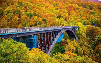
Jogakura Bridge: Video Introduction This video, titled "[Drone] Jogakura Bridge, Aomori / Aerial Drone Shots of Jougakura Bridge [4K]" (【Drone】青森 城ヶ倉大橋 / Aerial Drone Shots of Jougakura Bridge【4K】), was uploaded by "TinyBetter Drone Works 4K." The video showcases magnificent views of autumn foliage against the backdrop of the Jogakura Bridge in Aomori, Japan. We hope you enjoy the magnificent views captured via drone accompanied by wonderful music. Jogakura Bridge – Facts About the Beautiful Bridge in Aomori, Japan Photo:Jogakura Bridge, Aomori, Japan Jogakura Bridge is located in Towada-Hachimantai National Park in Aomori, in Japan's Tohoku region. National Route 394 connects the Tsugaru and Nanbu regions of Aomori Prefecture, and in October 1995, Jogakura Bridge was built over Jogakura Gorge, which had been a major obstacle previously. Needless to say, a great deal of effort was put into building the bridge, and many people worked hard to make it possible. Jogakura Bridge is 360 meters long, with an arch span length measuring 255 meters. It is the longest deck arch bridge in Japan, which have their deck is completely above the arch. The arch span length is the length of the bridge between the piers (the main span). The height from the valley floor is 122 meters! The view of the Hakkoda Mountains from the bridge is truly spectacular. The Best Time to View Autumn Leaves at Jogakura Bridge Photo:Autumn leaves from Jogakura Bridge, Aomori, Japan From Jogakura Bridge, visitors can enjoy views of the Hakkoda Mountains throughout Japan's four seasons, but autumn is especially popular, when the autumn leaves change to beautiful shades of red and orange. The best time to view the autumn leaves is in mid-October, and the picturesque scenery of the autumn leaves stretching far into the distance is a must-see. Mt. Iwaki, one of the 100 Famous Japanese Mountains, can be seen on the west side of the mountain. The view of Mt. Iwaki beyond the autumn leaves is one of the highlights of Jogakura Bridge, and will surely make for some great shots for any instagrammers or photographers out there. There are parking lots and restrooms at both ends of the bridge. From the observation space on the Kuroiwa side of the parking lot, visitors can take pictures of the arch bridge against the backdrop of autumn leaves. You can walk across the bridge's walkway and take your time snapping photos while viewing the autumn leaves. You can see tourists doing this throughout the video as well. Because it's filmed via drone, you can also see just how large and tall the bridge actually is. [Video] 1:25 - Tourists Walking Across the Bridge, Enjoying the Autumn Leaves Peering into Jogakura Gorge below, can be a bit daunting if you're afraid of heights. There used to be a walking trail that led down to Jogakura Gorge below the bridge, but it's now closed due to hazardous sections. Although you can't get up close to Jogakura Canyon, you can enjoy the panoramic view from 122 meters in the air. Hot Springs, Ropeways, and Other Popular Attractions Around Jogakura Bridge Photo:The Hakkoda Ropeway ●Sukayu Onsen This hot spring has been known as a therapeutic bath since the Edo period (1603-1868 A.D.). "Hiba Senninburo," a large, 290 square meter mixed bathing area constructed entirely of hiba (cypress), is what makes this hot spring so special. The retro atmosphere is also popular. ●The Hakkoda Ropeway Located in the northern part of Towada-Hachimantai National Park, the ropeway connects the base station and the summit park station via a 10-minute gondola ride, offering spectacular seasonal views, such as autumn leaves in the fall and ice-covered trees in winter. From the ropeway station, a walking trail is available where visitors can enjoy a 30-60-minute stroll. ●Jigoku-numa Pond A swamp created as a result of the former volcanic activity of the Hakkoda Mountains, located not far from Sukayu Onsen Hot Spring. Even today, sulfur-containing gases spew forth from the surrounding fumaroles, and highly acidic, 90-degree Celsius water gushes into the pond. Summary of Jogakura Bridge Jogakura Bridge, built in a harsh natural environment high in the air, features a spectacular panoramic view. Did you get a chance to check out the beautiful autumn leaves in the video? In addition to the autumn foliage, winter, spring, and summer are also beautiful, so if you get the chance, we definitely recommend visiting during these seasons as well. There is also a well-known soba restaurant near Jogakura Bridge. Some serve tempura made with vegetables grown in the surrounding mountains with soba, while others even have tempura apples, a specialty of Aomori Prefecture, and others even have soba pudding! Enjoy the vast nature of Towada-Hachimantai National Park while also enjoying some delicious local food! 【TripAdvisor】Jogakura Bridge https://www.tripadvisor.com/Attraction_Review-g298241-d2471814-Reviews-Jogakura_Bridge-Aomori_Aomori_Prefecture_Tohoku.html -
 Video article 3:12
Mt. Daisen and Kitanizawa Stream - Two Places Used to Make Commercials With Famous Artists! Be Amazed by the Natural Scenery of Tottori Prefecture in This 4K Video!
Nature- 279 plays
- YouTube
Mt. Daisen and Kitanizawa Stream in Tottori Prefecture This video, titled "[4K UHD] Summer Mt. Daisen and Kitanizawa stream" ([ 4K UHD ]夏の伯耆大山と木谷沢渓流 Mt.Daisen & Kitanisawa Stream in Summer), was created by AQUA Geo Graphic. It's an introductory video showing Mt. Daisen and Kitanizawa Stream. Mt. Daisen is a mountain at 1,729m (5,700 ft.) above sea level in Tottori prefecture, in Japan's Chugoku region. It is a stratovolcano, but it is not active at present. It is also known as the sacred peak that represents the Chugoku region of Japan. Mt. Daisen is sometimes called Pansan or Hoki Daisen. The name Hoki Daisen derives from the history of western Tottori Prefecture, which was once called Hoki Country. Mt. Daisen is a popular scenic location that has been selected as one of Japan's "Top 100 Mountains" and Japan's "Top 100 Views." The Kitanizawa Stream is a clear stream that originates from Mt. Daisen, and is also designated as a walking route for sightseeing on Mt. Daisen. It is filled with many tourists, especially during the fall foliage season. The video introduces the fresh greenery of Mt. Daisen and the Kitanizawa Stream in beautiful 4K footage. You can enjoy the beautiful natural scenery, the chirping of birds, and the natural sounds of the flowing river, making it seem as if a mountain stream is actually flowing right in front of you. Mt. Daisen and Kitanizawa Stream- Two Beautiful Instagram Locations Photo:Kitanizawa mountain stream When visiting Mt. Daisen, we recommend taking a guided tour with the Oku-Daisen tour guide. It's a popular walking tour where you can enjoy the seasonal natural scenery, such as bird watching in the summer, autumn leaves in the fall, and snowshoeing in the winter. Keep in mind that the tours require a minimum of people before starting. Reservations can be made with the Kofu Tourism Association by phone or email. The first Saturday of the month is Kitanizawa Tour Day, which includes a photo and allows pets and elementary school students to accompany the tour. Feel free to sign up for this walking route, as it's a great way to capture some Instagram-worthy pictures. The crater at the top of Daisen is marked by the rim of a volcano, indicating that it was once a volcano. It's also locally called Hoki Fuji. If you fancy yourself a hike, why not try climbing to the famous Hoki Fuji Rim to see the natural landscape of Mt. Daisen? Speaking of Mt. Daisen, in winter, we recommend the Oku-Daisen Ski Resort. It's the largest ski resort in Tottori Prefecture, with 400 free parking spots. Reservations should be made early, as the resort is quite popular. Oku-Daisen Was Used for Suntory's Natural Water TV Commercials! Photo:Houki Fuji among the stars In 2017, a commercial for Suntory Natural Water, featuring world-renowned female artist Utada Hikaru, was set in Oku-Daisen, a famous mountain that is said to be the highest peak in the Chugoku region. Oku-Daisen is a place where the air and water are so clean that it is said to be a mountain of water, and the atmosphere of its mysterious forest is something straight out of an anime or some other mythological world! The numerous climbing spots capture the hearts of visitors. Okudaisen (奥大山) has a vast beech forest, where you can enjoy a panoramic view of the majestic mountains, and you can see the beautiful starry sky that Utada Hikaru sang about in the TV commercial "#Hoshi Suge" (These stars are beautiful!). The mountain stream that Utada Hikaru visited in the TV commercial is featured throughout this video, where you can enjoy the clear river water of the naturally flowing stream. If you watch the video, you might be able to feel what Utada Hikaru felt, surrounding by the natural beauty of Okudai Mountain. Mountain Climbing and Sightseeing at Mt. Daisen and Kitanizawa Stream Kofu City (江府町, Kofu cho), in Tottori Prefecture, is home to Oku-Daisen, mentioned earlier in the article. The air here is incredibly clear, making it a great place for stargazing, and many campers and photographers come here every year. In the surrounding downtown area and hotels, you can enjoy incredible gourmet cuisine, such as seafood from the Sea of Japan. Summary of Mt. Daisen and Kitanizawa Stream Hoki Daisen Station (JR West) in Yonago is a convenient way to get around, especially for trips to Mt. Daisen, home to the Kinayazawa Stream, one of the clearest rivers in Japan. We recommend using a local bus for transportation from Hoki Daisen Station to hotels, accommodations, and tourist destinations around Mt. Daisen. The highlight of this video is the Kitanizawa Stream, which is shown from 0:36 to the end of the video. The clear water flowing through the lush greenery of a mountain stream in summer, the beautiful moss on the rocks of the stream, and the beautiful sound of the river. It's a truly amazing atmosphere. The video is pleasing to both the eyes and ears. Please enjoy the beauty of Mt. Daisen and the Kitanizawa mountain stream. -
Video article 5:26
The Hoshitoge Rice Terraces of Niigata Prefecture! Discover the Beautiful Rice Fields of Japan With This Must-See View!
Nature Travel- 50 plays
- YouTube
Hoshitoge Rice Terraces: Video Introduction This video, titled "[4K] [Original Scenery of Japan] Rice Terraces at Hoshitoge, Tokamachi, Niigata Prefecture" ([4K]【日本の原風景】新潟県十日町星峠の棚田。雲海と光芒。), was uploaded by "KYODO NEWS." In the video, you can see footage of the Hoshitoge Rice Terraces, which were selected by foreign tourists as the #1 bucket list view in Japan. The reflections on the water-filled rice fields and the sea of clouds that looks different throughout the day are captured in this beautiful 4K video. You can't help but be moved by these views. The video is accompanied by closed captions with tourist information, so be sure to turn them on while watching the video! Rice Fields in Japan Cultivation of rice fields in Japan is believed to have started during the Yayoi Period (300 BC - 250 AD). Rice has played an important role in the history of Japan, and has even been used historically as currency by farmers to pay taxes. Today, rice is a staple food in Japan, and while the exact number of rice fields in Japan is not known, according to the Ministry of Agriculture, Forestry and Fisheries, rice paddies account for 5.85 million acres of land. With Japan having a total landmass of 93.4 million acres, this means that more than 6% of Japan is rice paddies. Despite rice fields being made to grow rice, there are many places in Japan where you can see rice field art, such as Saitama and Aomori prefectures. The use of different colors of rice allows farmers to create incredible images inside the fields. Some other famous rice fields in Japan where you can see breathtaking views include the Shiroyone Senmaida Rice Terraces of Ishikawa Prefecture, the Maruyama Senmaida Rice Terraces of Mie Prefecture, and many more. Terraced rice fields prevent erosion, runoff, flooding, and other undesirable conditions, which is why they are often used in rice farming. Furthermore, they help nurture the land by allowing the water in the fields to slowly seep back into the ground, replenishing the groundwater. What Are the Hoshitoge Rice Terraces? Discover the Beautiful Scenery of Tokamachi, Niigata Photo:The Hoshitoge Rice Terraces of Tokamachi, Niigata Located in Tokamachi, Niigata, in Japan's Koshin'etsu region, the Hoshitoge Rice Terraces, numbering some 200 paddies, are spread across the hillside. Among the terraced rice fields scattered throughout the region, the Hoshitoge Rice Terraces are considered exceptionally beautiful. Depending on the weather and time of year, a sea of clouds and mirror-like water can also be seen at the rice terraces, making this a popular tourist spot with a variety of views. The Hoshitoge Rice Terraces have attracted attention both in Japan and overseas, as they were featured in the opening scene of NHK's historical drama "Tenchijin" (Heart of a Samurai) in 2009, and was recognized as a Japanese heritage that transcends borders by the Ministry of Agriculture, Forestry and Fisheries in 2022. The Hoshitoge Rice Terraces, a place where you can view the beautiful landscapes of Japan, are historic terraced rice fields created by the residents of Hoshitoge village more than 300 years ago. The area, including the village, has been selected as one of the "Top 100 Villages in Japan," and is one of Japan's leading scenic attractions. The Best Season to Visit the Hoshitoge Rice Terraces Photo:A sea of clouds over the Hoshitoge Rice Terraces, Tokamachi, Niigata One of the highlights of Hoshitoge Rice Terraces is the breathtakingly beautiful sea of clouds and mirror-like pools of water covering the fields. Unfortunately, the sea of clouds and mirror-like pools can only be seen during certain times of the year and under certain conditions. In addition, in order to capture the beautiful scenery in photographs, it's important to know in advance the best places to take photographs, so be sure to check before you visit. The best seasons for seeing a sea of clouds is during spring (late June) and autumn (mid-September). During these seasons, a sea of clouds is more likely to occur, and photographers from all over Japan flock to the area to enjoy the spectacular view. On the other hand, the best season for viewing the mirror-like pools is spring (around May to June) and autumn (around October to November). If you want to see both a sea of clouds and the mirror-like pools, be sure to visit in June. However, whether or not you can see a sea of clouds and a water mirror depends entirely on luck. The view in front of you will change depending on the conditions of the day. You will need some luck to take a good picture. However, if the conditions are right, you will be able to see a glowing sea of clouds or a scene enveloped in fog, and you will be able to capture a miraculous shot. Spring, Summer, Fall & Winter: Seasonal Views at the Hoshitoge Rice Terraces Photo:The Hoshitoge Rice Terraces covered in snow, Tokamachi, Niigata The Hoshitoge Rice Terraces are a beautiful sight in each of Japan's four seasons. In addition to the popular sea of clouds and mirror-like pools, you can enjoy colorful cherry blossoms in spring. In the summer, the rice terraces turn a deep green color and contrast with the bright blue sky. In autumn, the ears of rice shimmer with a golden glow, and in winter snow takes the place of water, creating a unique scene of pools of white snow. That being said, cars and motorcycles are unable to access the rice terraces when the snow gets too deep, and you may not be able to visit the rice fields during the winter. The Hoshitoge Rice Terraces also offer a different view during the daytime and at night. In particular, at sunrise and sunset, you can enjoy a beauty that is beyond words, no matter what season you visit in. Summary of the Hoshitoge Rice Terraces The Hoshitoge Rice Terraces are one of the most famous scenic views in Japan. It's a bucket list location, so if you're interested in visiting, we highly recommend adding it to your Niigata travel itinerary! To get to the Hoshitoge Rice Terraces in Tokamachi, Niigata, take the train to Matsudai Station and from there, it's about 20 minutes by taxi. For details on parking and directions, please check here. The rice terraces in Tokamachi, Niigata, including the Hoshitoge Rice Terraces, are not designed for the purpose of sightseeing. They are agricultural land that local people have inherited from their ancestors and carefully preserved. They are also private plots of land where farmers still cultivate rice. In addition to not entering the terraces, it's strictly prohibited to interfere with farm vehicles, take unauthorized photographs of farm work, or leave trash in the terraces. Please enjoy the spectacular scenery while observing proper manners and abiding by the rules. 【TripAdvisor】Hoshitoge Rice Terraces -
Video article 4:00
The Beautiful Rice Paddies of Japan in 4K. Golden Ears of Rice Painted on the Horizon Bring Peace to the People of Japan
Nature- 250 plays
- YouTube
Like a Work of Art! Japan’s Rice Paddies Are Unbelievably Beautiful Before the Autumn Sunset To us Japanese, our staple food is rice. And where there is rice, there are rice paddies! You'll be completely absorbed by the view of the rice paddies during the autumn season that the 4K video “Japan Rice Paddies in autumn afternoon-views of rice paddies before the autumn sunset 4K (Ultra HD)(Japan Rice Paddies in autumn afternoon - 田んぼの風景・秋の夕暮れ前 4K (Ultra HD))” has to offer. The place where they shot the footage is the paddy field area in Aizu of the Fukushima prefecture, in the rice-producing district of Japan's Tohoku region. From the beginning of the video, you can see the Japanese pampas grass around the rice paddy, and from 1:19, the ears of rice slowly being colored into a golden hue can be seen as well. The singing of the insects combined with the melody of the nearby river also relaxes the mind and makes you feel at peace. These kind of rural landscapes aren't uncommon in Japan either. The most Instagrammable, breathtaking sights to behold are the “Senmaida” and the “Tanada”, which are rice paddies or rice terraces that are cut into the steep mountain slope in a stair-like shape. This miraculous scenery is the crystallization of the wisdom of our ancestors. How Much Do You Know About Japan’s Paddy Fields? Photo:Rural landscape The scenery of Japan’s rice paddies is said to be the absolute perfection of inner peace and relaxation. However, how much do you know about Japan's rice paddies? The scientific name for Japanese rice is "Japonica rice" and as you've probably guessed, it originates from Japan. In the history of paddy field cultivation, Indica rice was cultivated in Southeast Asia. However, this rice is different from Japonica rice. The rice eaten in the present day, which has a special characteristic that makes it suitable for the Japanese climate, has a long history of agriculture in Japan. Photo:Rural landscape So, we will now introduce some basic knowledge about the rice paddies of Japan. First of all, the map symbol of a rice paddy is 2 lines. This symbolizes the “Aze” (the furrow between the paddy fields). The rice paddy is thought to be part of an idyllic scenery of nature. However, it is a man-made agricultural land formation, and the furrows are man-made paths between each rice paddy so people can work on the fields. Between the furrow and the rice paddy, there are waterways that help manage water. Paddy fields are measured in units called “Tan” and 1 Tan is about 991.74 square meters big. Rice Paddies and the Divine Photo: White rice Shinto is an original religion of Japan and deifies nature. The highest object of worship is the Emperor. Every year in November, there is The Niiname Festival(新嘗祭,Niiname-sai), held in the Imperial palace, in which the emperor prays for a bountiful harvest in the coming year. During this time, grains that are harvested from a lucky direction as designated through divination, will be eaten by both the Emperor and Empress. As you can see, for Japan, planting rice is not just an act of agriculture; it has significant cultural relevance as well, and rice was also used to pay annual tribute (presently known as taxes) in the past. Therefore, rice paddies were an important infrastructure that have supported the very heart of Japan since ancient times. How to Make Paddy Fields Photo:Rice planting Rice cultivation is in autumn. Depending on the region, however, usually the preparation of rice beds and seedlings start around March. There are many things that need to be done to prepare for rice planting as well: repairs on furrows, spreading of fertilizer, plowing and irrigating the fields ( to prevent damage from weeds or water leakage), filling the paddies with water, and then finally planting the rice seedlings. Come summertime, weed killers and pesticides are used to manage the growth of the rice, and in autumn the rice is harvested, some made into seedlings again, and the rest is threshed and put on a rice rack to dry. Referred to as "tilling", this act involves creating hills and soil beds in the rice field, as well as creating ice-field furrows and dams. In the modern day, much of the work is mechanized, however, in the past this was all done by hand. Summary of Japan’s rice paddies Photo:Rice paddy in Summer A rice paddy and a regular farm field are very different in terms of plowing, and grains other than rice are made in regular fields but not in rice paddies. That just goes to show how special of a crop rice is to the Japanese people. Also, because rice paddies are abundant with water, many living creatures gather near them, such as the aquatic stink bug, the diving beetle, the pond snail, and sparrows. Sometimes damage to crops does occur, however, there is a very rich ecosystem within the paddy fields. Recently, the aging of the rice farmers has led to many rice fields being fallowed. The original scenery of Japan, “Sunset on the rice paddies” is an incredible view that we want to preserve for future generations. -
Video article 1:51
Shirahama Beach - Discover the Beauty of Shimoda, Shizuoka at Izu's Largest Swimming Beach! The Bright Red Torii Gate Perched on the Cliffs Makes for Some Amazing Scenery!
Nature Travel- 289 plays
- YouTube
Shirahama Beach in Shizuoka Prefecture! The video this time is titled "Shirahama Beach - Shizuoka - 白浜 - 4K Ultra HD." It introduces the beautiful Izu-Shirahama Beach in Shimoda City, Shizuoka prefecture. When the weather is nice, Shirahama Beach glows a beautiful emerald green, making it very popular with surfers and tourists alike. The 700-meter-long white sand beach is one of the largest on Izu Peninsula. Enjoy making lasting memories at one of the most beautiful beaches in Japan! Don't forget to bring your camera either; There's plenty of great places to take pictures for your Instagram! Shirahama Beach, Shizuoka Photo:Shizuoka prefecture・Shirahama Beach Shirahama Beach, located in Shizuoka prefecture in Japan's Tokai region, is separated into 2 swimming areas: the Shirahama Central Beach section and the Shirahama Ohama Beach section. Shirahama Ohama Beach is the largest beach in the Izu peninsula area. Shirahama Beach becomes very lively during the summer with the Shirahama Fireworks festival being held there as well. Many young people looking to party gather here and the atmosphere becomes very different than that of the afternoon. The Red Torii Arch at Shirahama Beach Photo:Shizuoka prefecture・Ikona Hime No Mikoto Shrine The torii arch on the coastline, which can be seen at 0:30 in the video, is actually Ikona Hime No Mikoto Shrine, the oldest shrine in Izu. It is commonly called Shirahama Jinja Shrine. The contrast of the bright red beach torii and the emerald green sea is breathtaking. The goddess Ikona, who is the wife of Mishima Daimyojin, is enshrined as the main deity of Ikona Hime No Mikoto Shrine, and is believed to be the goddess of women. If you visit the shrine, it will bring good luck in marriage and increase your romance abilities! The large rock facing the sea is called Daimyojin Rock and is known as a power spot. In addition, at the bottom of the cliff behind the main building, there is a spot called Ogama, which is a sea-eroded cave into which sea water flows. Summary of Shirahama Beach Photo:Shirahama Beach in Shimoda City, Shizuoka Prefecture The Izu area of Shizuoka Prefecture is dotted with hotels, inns, guest houses, cottages, camping sites, and other accommodations. There are also many restaurants where you can enjoy excellent food. If you're looking to hit up some beaches to soak up some sun, don't miss out on Shirahama Beach! Shirahama beach is a 13-minute bus ride from Izukyu Shimoda Station, and there are paid parking lots in the area as well. Shirahama beaches, named after their characteristic white sand (白浜, shirahama, lit. "white sand"), can be found in places other than Shizuoka prefecture as well, including Wakayama prefecture, Chiba prefecture, and Kanagawa prefecture. Japan has a lot of beaches with beautiful sand and great views, so get ready for some fun in the sun! 【Tripadvisor】Shirahama Central Beach https://www.tripadvisor.com/Attraction_Review-g1019670-d1313436-Reviews-Shirahama_Beach-Shimoda_Shizuoka_Prefecture_Tokai_Chubu.html -
Video article 3:26
The Beauty of Mie Prefecture's Tea Plantations Will Blow You Away! Introducing the Popular Tea of Mie Prefecture, the Third Largest Producer of Tea in Japan!
Nature- 169 plays
- YouTube
Mie Prefecture's Tea Plantation! There are many tea plantations around Japan. In this article, we'll introduce the tea plantations of Mie prefecture alongside a 4K video. The video, titled "Mie Green Tea Fields - 4K Ultra HD," was created by "TokyoStreetView – Japan The Beautiful." The video introduces a famous tea called "Isecha" (伊勢茶), that's produced in Mie prefecture. The Kamize tea plantation by the Miyagawa river in the Odai Sankei area of Mie prefecture's Taki district is famous for producing high quality Japanese tea. Don't miss out on the beautiful scenery of the paddy fields and green tea plantations in this video! The History and Types of Tea Plantations in the Video Photo:A tea plantation in spring Isecha is thought to have been grown in Mie Prefecture for over 1,000 years. It's said that from the Muromachi period (1336-1573 AD) to the Edo period (1603-1863), priests and merchants carried Isecha to all corners of Japan. Japanese tea leaves are picked from shrubs, such as those seen at 0:41 in the video. The Japanese tea leaves harvested from the tea plantations are sorted into a variety of types, depending on how they were cultivated and processed. These varieties include teas such as Sencha (煎茶), Kabusecha (かぶせ茶) and Gyokuro (玉露). When Is Japanese Tea Harvested and How Can You Purchase It? Photo:Tea plantation・Tea picking Tea farmers in Japan pick the first tea of the year around May. An event is held at the Kamize tea plantation (introduced in the video) where leaves are picked to be used as an offering to Ise Grand Shrine. Japanese tea can be purchased at either tea shops in the area or online. There are also many cafés where you can try a variety of Japanese teas and traditional sweets. The Top Tea Producing Areas in Japan! Photo:Green tea and tea leaves Areas famous for tea production in Japan include the Mount Fuji area of Shizuoka prefecture, Kyoto prefecture, Miyazaki prefecture, and Kagoshima prefecture. The Kamize and Suizawa (水沢) tea plantations of Mie prefecture are also known for producing high quality Japanese tea. The largest producers of tea in Japan (based on production volume, production cost, and cultivation area) are ranked as follows: No.1 – Shizuoka prefecture No.2 – Kagoshima prefecture No.3 – Mie prefecture Summary of Mie Prefecture's Tea Plantation Photo:Tea plantation We hope you enjoyed the view of the beautiful tea plantations introduced in the video. During the peak of the tea growing season, the tea plantations in Mie prefecture, in areas such as Suzuka Yokkaichi, Oku Ise Odai, and Suizawa, create some incredible scenery. At 2:17 in the video, you can see the beautiful scenery of the tea plantations surrounded by mountains. In the Ise-Shima area you can also see the amazing single cherry blossom tree known as "Iwatozakura" (岩戸桜). If watching this video has sparked your interest in Japanese tea, we highly recommend visiting a tea plantation during the height of the tea season to enjoy some amazing sightseeing and delicious tea! -
Video article 1:39
Baikamo – Flowers That Bloom Only in the Clearest Water. Beautiful Underwater Images of the Summertime Flower
Nature Travel- 121 plays
- YouTube
Baikamo Blooming on the Takimi River in Hyogo Prefecture: Video Introduction This video, titled "Baikamo|A Flower Only Found in Japan [Shinonsen] 4K" (バイカモ 日本固有種 【新温泉町】4k), was uploaded by "e production.com" (e映像制作.com). Have you ever heard of the plant baikamo? In this article, we'll introduce an underwater flower that blooms in the Takimi River in Shinonsen, Hyogo. Be sure to check out the video to see the beautiful baikamo blooming in the clear stream. Baikamo – A Look at the Flower Blooming on the Takimi River in Hyogo, Japan Source :YouTube screenshot From the beginning of the video, you can see baikamo growing as birds chirp and the gentle sound of the river plays in the background. The video is very striking, as if it were shot from a bird's eye view. The location shown in the video is Baikamo Park. There are not many areas in Japan where baikamo can be found in such abundance. Baikamo is a plant that grows in tall mountains where the water is very cold, so it's rare to see it growing in clusters. Unfortunately, the baikamo colony on the Takimi River began to shrink in size around 2017, and as of 2022, not many baikamo can be seen anymore. Baikamo, a Flower that Blooms Under Water Photo:Baikamo Baikamo is a species endemic to Japan. The baikamo, which blooms along the Takimi River in Shinonsen, belongs to the buttercup family, Ranunculaceae, and has the scientific name of Ranunculus Kazusensis Makino. In floriography (the language of flowers) its meaning is "Happiness will come." Just as the language of flowers suggests, the small, pretty flowers blooming on the surface of the water make people happy just by looking at them. There is also a type of baikamo called ginkgo baikamo, which can be seen in some areas of Japan. This flower blooms from early summer to early fall, with white flowers 1-2 cm in diameter. The flowers resemble plum blossoms, and because of this, baikamo is often written with the kanji 梅花藻 (梅, Bai "Plum"; 花 ka "Flower"; 藻 mo "Algae"). It's a perennial flower that grows underwater and is characterized by its evergreen nature. It is also edible as a wild plant. Where Can Baikamo Be Found in Japan? Photo:The Jizo River, Awai, Shiga The baikamo featured in this video can be seen in Japan's Kinki region, such as the Jizo River in Awai, Shiga, and Kamikawa, Hyogo. Other locations include Echizen, Fukui; Mishima Baikamo Park (三島梅花藻公園), Shizuoka; Chokeiji Temple (長慶寺) in Tsuru, Yamanashi; and the Shimizu River in Konan, Fukushima. There is also a baikamo colony in Eniwa, Hokkaido. Summary of Baikamo, an Aquatic Plant That Blooms Only in Clear Streams Baikamo is an aquatic plant that blooms only in clear streams rich in nature. It's a pity that the number of baikamo has been decreasing due to various climate and environmental changes. However, there is good news from the Shimizu River in Tamba, Hyogo. The number of baikamo had been rapidly decreasing due to the decrease in water flow caused by the proliferation of weeds, but thanks to preservation activities by local residents, the baikamo population has been restored. It would be nice to see baikamo blooming beautifully again in the Takimi River like in the video. 【TripAdvisor】Baikamo Park https://www.tripadvisor.com/Attraction_Review-g1121310-d8368832-Reviews-Baikamo_Park-Shinonsen_cho_Mikata_gun_Hyogo_Prefecture_Kinki.html -
Video article 3:35
Shirasaki Coast in Wakayama Prefecture, Called the "Aegean Sea of Japan," Is Just Like a Painting! Introducing the Charms and Activities of Shirasaki Coast!
Nature- 116 plays
- YouTube
Introducing Shirasaki Coast in Wakayama Prefecture! This video, titled "Shirasaki Coast (Wakayama) A Beautiful Scenic Location Called the Aegean Sea of Japan" (白崎海岸(和歌山)日本のエーゲ海と称される絶景スポット), was released by "K Japan Traveler." Shirasaki Coast in Wakayama prefecture, which has a magnificent view on Instagram, was selected as one of the Top 100 Beaches of Japan, and in 2009, it was also selected as one of the Top 100 Landscapes of the Yomiuri Shimbun. Many tourists visit the beach throughout the year, where the contrast between the blue of the sea and sky and the pure white of limestone and sandy beaches is attractive. The History and Highlights of Shirasaki Coast Photo:Shirasaki Coast, Wakayama Prefecture Shirasaki Coast is the sea of the Shirasaki Coast Prefectural Natural Park in Yura, Hidaka District, Wakayama Prefecture, and, as you can see at 0:33 in the video, is characterized by the white limestone surrounding it. Geologically, limestone is said to have come from the Permian Period in the latter half of the Paleozoic Era, more than 200 million years ago. From spring to summer, a large group of black-tailed gulls fly to Shirasaki Coast in Wakayama prefecture, which is rich in nature, as you can see from 3:03 in the video. The marine park is also known for its daffodils. Things To Do at Shirasaki Coast in Wakayama Prefecture Photo:Shirasaki Coast, Wakayama Prefecture We recommend enjoying swimming, fishing, and Shirasaki cruise activities around Shirasaki Coast in Wakayama prefecture. There are also diving spots and diving pools nearby. From Shirasaki Manyo Park, we recommend enjoying the view of the strange rocks "Tatego" and "Oobae," which are the symbols of Shirasaki Coast. Also, stop by Koukokuji Temple, the Shellfish Exhibition Hall, the Park Center, Shirasaki Marine Park Observatory, and Totsui Limestone Cave. Dining and Lodging at Shirasaki Coast Photo:The Starry Skies of Shirasaki Marine Park, Wakayama Prefecture Around Shirasaki Coast, there are many restaurants and cafes where you can eat seafood dishes such as Shirasu-don on a low budget as well as the famous Shirasaki curry. In addition, there's Roadside Station Shirasaki Ocean Park where you can buy souvenirs, and hotels that are ideal for accommodation, so plan your trip carefully! Summary of Wakayama Prefecture's Shirasaki Coast As you can see in the video, the charm of Shirasaki Coast is that you can enjoy the spectacular blue and white scenery. When the sun sets, you can see a soothing view that you won't find during the day. Be sure to check out the business information and regular holidays for the Shirasaki Marine Park campsite and the surrounding facilities before visiting for sightseeing. ◆ Introduction to Shirasaki Coast ◆ 【Address】Take a bus from JR Kii-Yura Station and get off at Shirasaki Nishi, and walk 1.5 km. 【Parking】Free Parking Available 【Tripadvisor】Shirasaki Marine Park https://www.tripadvisor.com/Attraction_Review-g1121347-d1385202-Reviews-Shirasaki_Ocean_Park-Yura_cho_Hidaka_gun_Wakayama_Prefecture_Kinki.html -
Video article 3:09
The Carpet of the Gods – Aerial Footage of Autumn Leaves on Mt. Kurikoma. Experience a Sea of Clouds, Sunrise, and Brilliant Autumn Colors on the Mountain Spanning Miyagi, Iwate, and Akita Prefectures!
Nature Travel- 76 plays
- YouTube
The Carpet of the Gods – Autumn Leaves on Mt. Kurikoma: Video Introduction This video, titled "Autumn Leaves on Mt. Kurikoma|The Carpet of the Gods|Amazing Aerial Footage (Shot on a Phantom 4 Pro)" (栗駒山の紅葉 神の絨毯 絶景空撮 - Autumn Foliage at Mt.Kurikoma, Aerial Footage - (shot on Phantom 4 Pro)), was uploaded by "AQUA Geo Graphic." Straddling Miyagi, Iwate, and Akita prefectures, Mt. Kurikoma is a mountain known for its beautiful autumn leaves. Its appearance is said to resemble that of a carpet for the gods. Mt. Kurikoma is a bucket-list location, and this video shows footage of the breathtaking mountain from the sky. Be sure to check it out as you read along. The Beautiful Autumn Colors of Mt. Kurikoma Photo:Mt. Kurikoma, Miyagi Prefecture Mt. Kurikoma is a 1,626-meter-tall volcano located in the central Tohoku region of Japan. It's known for its abundance of alpine flora, and is popular not only for hiking in the fall, but also in the spring and summer. Thanks to its many deciduous trees, including primeval beech forests and maple trees, the entire mountain changes color in autumn. The summit is of course spectacular, but the mountain features excellent viewpoints for the red and yellow autumn leaves as you hike your way to the top. The mountain is crowded with hikers who come to see the beautiful autumn leaves in the fall. There are nine different hiking courses on Mt. Kurikoma, and hikers can choose the one that best suits their fitness level and experience, which is one of the reasons it's so popular. When to See the Autumn Colors on Mt. Kurikoma Photo:The Carpet of the Gods - Autumn on Mt. Kurikoma Mt. Kurikoma is usually at its best from late September to mid-October. The autumn foliage begins near the summit and gradually spreads over the entire mountain, creating what is called "The Carpet of the Gods," as seen in the video. In 2022, the autumn foliage reached Iwakagami-daira at the trailhead on October 6. The "Carpet of the Gods" is so beautiful you can't help but gasp [Video] 0:33 - Autumn Leaves and the "Carpet of the Gods" on Mt. Kurikoma The entire mountain is truly a photogenic sight during the autumn, leading to crowds every year. When the autumn leaves are in season, the trailhead parking lot fills up quickly, creating traffic jams. For a limited time on weekends and holidays, an bus runs between Kurikoma-Kogen Station and the Iwakagami-daira trailhead, so visitors may want to consider using this service. Hiking on Mt. Kurikoma – Great for Beginners! Photo:Hiking on Mt. Kurikoma in autumn, Miyagi Prefecture Mt. Kurikoma has many well-maintained hiking trails. All trails can be enjoyed on a day trip, making it a pleasantly accessible hiking destination. Among the nine mountain trails, the Chuo Course and Higashi Kurikoma Course, which start from the Iwakagami-daira trailhead, are recommended for beginners. The Chuo Course, in particular, is the shortest trail (about 3 km) and it takes about 2 hours on average to hike it. It's recommended for beginners and families. The Sukawa Course from Sukawa Kogen Onsen is another trail suitable for beginners, but please note that it is currently partially closed due to high concentrations of volcanic gases (please check the latest news of the Iwate Prefecture official website). You can see what the hiking trails look like in the video as well. [Video] 1:39 - Mt. Kurikoma Hiking Trails Hot Springs Near Mt. Kurikoma; a Great Way to Relax After Hiking & Enjoying the Autumn Leaves Photo:Oyasu Valley in Autumn Next, we'll introduce some nearby sightseeing spots you can enjoy after viewing the autumn leaves at Mt. Kurikoma. There are several hot springs around Mt. Kurikoma where you can relax after a nice day of hiking: Sukawa Kogen Onsen (Ichinoseki, Iwate), Sukawa Kurikoma Sanso (Ogatsu, Akita), Shinyu Onsen Kurikomaso (Kurihara, Miyagi), Oyasukyo Onsen (Yuzawa, Akita), and Doroyu Onsen (Yuzawa, Akita). In addition to overnight stays, day-trip hot spring visits are also available, so consider stopping by one of these hot springs after a drive. Please keep in mind that traffic jams can occur and parking lots may be full during fall when the autumn leaves are in season. In addition, there will be sections where cars are restricted as well, so be sure to check hot springs' website for up-to-date information. In addition to the hot springs, other popular tourist attractions include the Kurikoma Foothills Geopark Visitor Center, Fukayama Pasture, and the some of the local restaurants. Summary of Autumn Leaves on Mt. Kurikoma Mt. Kurikoma, one of Japan's "Top 100 Mountains for Flowers," is a popular tourist attraction for viewing both the fresh greenery of summer and autumn leaves in the fall, as well as alpine flowers and grasses throughout the year. If you're visiting from far away, we recommend staying at a hot spring hotel after hiking the mountain and enjoying delicious sake and local cuisine from Japan's Tohoku region! It's also a wonderful way to enjoy the autumn leaves. In the video, you can see the sunrise over a sea of clouds, as well as splendid views of the autumn leaves. [Video] 0:00 - Sunrise Over a Sea of Clouds on Mt. Kurikoma Mt. Kurikoma is called the "Carpet of the Gods" because of its spectacular views. We invite you to visit Mt. Kurikoma and experience its beauty for yourself! 【TripAdvisor】Mt. Kurikoma https://www.tripadvisor.com/Attraction_Review-g1023415-d1386243-Reviews-Mt_Kurikoma-Kurihara_Miyagi_Prefecture_Tohoku.html -
Video article 2:28
Enjoy the Majestic Natural Scenery of Mt. Chokai and Tobishima Geopark in Akita Prefecture! Discover the Beauty of Shirataki Falls and the Mototaki Underflow!
Nature- 93 plays
- YouTube
Introducing Mt. Chokai and Tobishima Geopark in Nikaho City, Akita Prefecture This video, titled “[4K UHD ] Mt. Chokai/Tobishima Geopark: Fresh Greenery and Mototaki Falls (Shot on GH5 With Gimbal)” ([ 4K UHD ]鳥海山・飛島ジオパーク: 新緑の元滝伏流水 Moto-taki Waterfall ( shot on GH5 with Gimbal)), was released by “AQUA Geo Graphic.” Mt. Chokai & Tobishima Geopark is the name of Akita Fuji (秋田富士), Dewa Fuji (出羽富士), and Shonai Fuji (庄内富士), which have been selected as some of the 100 Famous Mountains and 100 Famous Geographical Features of Japan. Furthermore, it is also the name of the "Mysterious Island Tobishima" and "Chokai National Park," which is located about 30 km west of Mt. Chokai, and was recognized as a Japan Geopark in 2016. Nowadays it's called Mt. Chokai, but in ancient times it was known as "Torimiyama" and you could see a 360-degree view of the horizon from the top. Due to volcanic eruptions and other volcanic activities, this view is no longer visible and it is now called Mt. Chokai. The overall theme is "The cycle of water and life created by the Japan Sea and the plateau," and the sub-theme is "Nature and life created by warm currents, active volcanoes, and spring water." In this article, we'll introduce the "Mototaki Underflow," an ethereal waterfall flowing down a rock face at the foot of Mt. Chokai in the Mt. Chokai & Tobishima Geopark area. What Exactly is a “Geopark”? Photo:Mototaki Underflow, Akita Prefecture The word "geopark" (“ジオパーク” jiopaaku in Japanese) is a combination of the words “geo” and “park.” It was selected for the purpose of learning about the natural environment and ecosystems that spread across the land, as well as the culture and industries that people have created. At present, there are 43 areas selected as Japan Geoparks, and 9 of them are also recognized as UNESCO Global Geoparks. As they are sometimes called "大地の公園" (Daichi no Kouen, lit. "Earth Parks") in Japanese, they are famous for the various scenery they offer throughout the year, and are especially popular during the fall with the autumn leaves change to beautiful shades of red and yellow. There is also a sake brewery in the area that uses clean spring water, so if you like sake, be sure to take a tour of the brewery. The Mototaki Underflow Located at the Foot of Mt. Chokai Photo:Mototaki Underflow, Akita Prefecture The Mototaki Underflow is located at Mt. Chokai in Nikaho City, Akita Prefecture. Although it is called "Mototaki" (元滝, lit. "source waterfall"), the original source of the subterranean waterfall is currently closed to traffic, and the Mototaki Underflow is located about 200 meters downstream. As you can see from 0:42 in the video, the waterfall is relatively small, only 5 meters tall and about 30 meters wide, yet 50,000 tons of water flow from it each day. The fantastic scenery created by the moss and the subterranean stream flowing out of the gaps in the green rocks is fascinating, and surely allows for some beautiful photos to share on Instagram. Recommended Sightseeing Destinations Around the Mt. Chokai & Tobishima Geopark Area Photo:Scenery from Hokotate Observatory, Akita Prefecture 1. Mt. Chokai Omonoimi Shrine/Fukura Kuchinomiya (Chokaisan Omonoimi Jinja Fukura Kuchinomiya) An old shrine, said to be the oldest shrine in the Shonai region, with origins dating back to 1963. It sits on the summit of Mt. Chokai, and there are two satomiya (shrines built in a village for the convenience of worshippers) called "Kuchinomiya" (口ノ宮, lit. "entrance shrines") at the foot of the mountain, one at Fukuura and the other at Warabioka. 2. The Shirai Rice Fields and Weirs This farmland was developed in 1800 based on the concept of rice fields for the Han-School of Shonai Chido-kan by Yadayu Shirai, the county representative of the Shonai domain. There are many innovative ways to heat and utilize the cool spring water of Mt. Chokai, and you can see the fruits of the wisdom of the area's ancestors here. It's a 10-minute drive east from Yuza Station. 3. Hokotate Observatory Mt. Chokai & Tobishima Geopark is also famous for its mountain climbing, and the Hokotate Observatory is a popular tourist spot where you can enjoy the magnificent view of Mt. Chokai. The observatory is located at the fifth station of the mountain, which can be reached by car, so it's possible to stop by during your drive, and there are a number of mountain lodges on the way to the summit, so you can take breaks as you go. When climbing the mountain, we recommend asking for a mountain guide or participate in a geotour so that you can learn more about Mt. Chokai. 4. Chokai Blue Line Chokai Blue Line is a mountainous road that rises from zero to 1,100 meters above sea level, and during the fall, amongst the autumn foliage, it offers a spectacular view worthy of any bucket list. Summary of Mt. Chokai & Tobishima Geopark Photo:Mototaki Underflow, Akita Prefecture Mt. Chokai and Tobishima Geopark has become a nature-rich spot called "緑のダム" (The Green Dam) due to the planting of beech trees by the townspeople to preserve water quality and purify the water source. In addition to sightseeing, be sure to try some gourmet foods like delicious Akita Iwagaki Oysters, which contain many minerals from the spring water! 【Tripadvisor】Mt. Chokai https://www.tripadvisor.com/Attraction_Review-g298237-d1397297-Reviews-Mt_Chokai-Tohoku.html -
Video article 3:13
Autumn Leaves in Hakkoda, Aomori - The Reflection of This Beautiful Red Foliage Is Poetic
Nature- 492 plays
- YouTube
Tourist Information for Viewing the Autumn Colors in Hakkoda and the Tsugaru Plains in Aomori This tourism promotional video (made by JAPAN GEOGRAPHIC) highlights the renowned autumn foliage in Hakkoda. Although Japan boasts many scenic sites to practice the traditional autumn foliage viewing, one of the 100 most beautiful Japanese mountains, Mt.Hakkoda has been very popular for the viewing of autumn colors in the countryside. The breathtaking view of autumn foliage reflected on the lake surface attracts a great number of visitors. The video navigates us through the beauty of autumn-colored Hakkoda which often appears on well-known travel sites or TV programs, and also has been a regular winner of the ranking of places in Japan to see autumn colors. Autumn leaves are best seen on a sunny day. The sunlight makes the red and yellow leaves shine. Winter comes early up in the north in Aomori. Such meteorological conditions give leaves vibrant colors. The video captures the spectacular color display in Hakkoda. Hakkoda: From Hot Springs to Beautiful Autumn Foliage Photo:Kenashitai Wetlands dyed in autumn colors Some hiking trails are maintained in Hakkoda so that hikers can take in the splendid autumn color display in the clear air, or enjoy the sounds of walking through the deciduous forests on a carpet of fallen leaves. Aomori Prefecture features many renowned hot springs. Staying at an Onsen Ryokan located in the area such as Sugayu Onsen (a very charming old-fashioned onsen hotel), Jogakura Onsen, or Tsuta Onsen will make your trip even more special. The recommended hiking route is an excellent 5-hour circular walking trail that starts and ends at Sugayu Onsen. The route takes you up to Mt. Otake and leads to the vast marshlands of Kenashitai. As plenty of visitors are expected during the peak of the autumn colors, it is better to book your room in advance. The Best Sightseeing Spots in Hakkoda Source :YouTube screenshot Aomori is one of the most popular tourist destinations in Japan. When it gets a color makeover from the autumn foliage, places like Mt. Hakkoda, Oirase Gorge, Zenkojidaira, Mutsu Bay or Jyogakura Oohashi are filled with tourists hunting for vibrant colors. Look at the breathtaking autumn vistas at Jigokunuma starting at 0:50! The red tinge with yellow, and vivid orange hues.... The stunningly beautiful color display is made mainly of Beech, Japanese rowan trees (nanakamado) and maple trees. "Tsutanuma Lake" (from 1:20 -) laying at the foot of Mt. Hakkoda is a hidden gem of the area. With the red leaves floating on the water, the lake has a mysterious beauty. The image of Lake Towada reflecting the mountains of autumn colors on its surface (from 1:42) is something you never get tired of looking at it. This explains why it is a photographers' dream destination. The symbolic scenery of the turning of autumn leaves contrasted with the water's surface is a magnet that pulls tourists back to this location. A Walk in the Sky With Hakkoda Ropeway Photo:Mt. Hakkoda, Ropeway The nighttime illumination during the autumn season allows visitors to admire the colors of autumn foliage from the sky until late hours. The approximately 10-minute sky walk in a gondola takes you up to the summit of Mt. Tamoyashidake offering you a look out of the colorful autumn mountains. Road Trip Information to Hakkoda in Autumn Photo:Autumn Leaves at Hakkoda Mountain Autumn foliage in the Tohoku region typically peaks from the beginning to the end of October. The route twisting through the mountains gives travelers a diverse views of the autumn leaves. From JR Aomori station, it takes about an hour to drive to Hakkoda. There is some parking in the area. Summary : 360° Panorama View From the Summit of Hakkoda - 4k Video of Autumn Colors Hakkoda is crowded with both domestic and international tourists in the autumn season, so we recommend checking traffic information and accommodation availability provided by the tourist information websites. Enjoy the video of the majestic autumn colors in Hakkoda! 【Tripadvisor】Hakkoda Mountains https://www.tripadvisor.com/Attraction_Review-g298240-d556800-Reviews-Hakkoda_Mountains-Aomori_Prefecture_Tohoku.html 【Official Website】Aomori Prefecture Tourist Information SIte - Aptinet https://www.en-aomori.com/ -
Video article 4:21
Fuji - Japan's Largest Tourist Attraction and the Pride of the Country. Its Mysterious Beauty Fascinates All Who See It
Nature- 186 plays
- Vimeo
An Introduction to Mt. Fuji This video is “Mount Fuji | A Time-lapse Film 4K,” made by Daisuke Shimizu. It is a 4K time-lapse of Mt. Fuji. Mt. Fuji is the highest mountain in Japan at 12,000 feet tall, spanning both Shizuoka and Yamanashi Prefectures. Since long ago it has been an object of worship under the name “Reihou Fuji.” In 2013 it was registered as a World Heritage Site, and it has become a famous mountain visited by more than 200,00 tourists, both Japanese and international, every year. Mt. Fuji is still an active volcano, but the last time it erupted was about 300 years ago (1707 AD) during the Edo period. This video introduces the beautiful scenery of Mt. Fuji through a 4K time-lapse. The highlights are the flowing, starry sky, the cityscape spreading into the hills, and the reflection of Mt. Fuji on the surface of a nearby lake. Enjoy the charm of the power spot, Mt. Fuji. Mt. Fuji: A World Heritage Site ©Koichi_Hayakawa Modifying Mt. Fuji is a mountain that spans Shizuoka Prefecture (in Fujinomiya CIty, Susono City, Fuji City, Gotemba City, Koyama-town Sunto-gun) and Yamanashi Prefecuture (in Fujiyoshida City and Narusawa-mura Minamitsuru-gun). It is a world-famous mountain that has been selected as one of Japan's "Three Great Mountains," "Japan's Top 100 Geological Sites," and as a World Heritage Site. In the past, Mt. Fuji was feared for its large eruptions and lava spills, and it was considered a mysterious mountain and an object of worship. It is said that when Mt. Fuji's eruptions subsided, trainees began to step into the mountain to gain the divine and spiritual power of Mt. Fuji. Nowadays, the Fujinomiya peak side of Mt. Fuji is home to Sengen Taisha Okumiya who worships Asama no Ookami (浅間大神), also called Konohanasakuyabime, as the main deity. Also, the summit of the Yoshida and Kawaguchi Lake (河口湖, Kawaguchiko) side is home to Kukushi Shrine. The beautiful figure of Mt. Fuji, said to be the symbol of Japan, has been drawn in various art works, such as the famous “Gaifu Kaisei,” drawn by the Japanese ukiyo-e artist Katsushika Hokusai. Mt. Fuji Is Also Popular Abroad! Photo:Mt. Fuji The mountain climbing season at Mt. Fuji differs by trail. Please note that it is completely closed outside of these climbing seasons. ・ Yoshida trail (Yamanashi Prefecture side): July 1 - September 10 ・ Subashiri trail (Shizuoka Prefecture side): July 10 - September 10 ・ Gotemba trail (Shizuoka Prefecture side): July 10 - September 10 ・ Fujinomiya trail (Shizuoka Prefecture side): July 10 - September 10 ・ Ohachi-meguri Trail (The trail of the crater's rim): July 10 - September 10 The trailhead is near the fifth station, and you can take the Fuji-Subaru Line/Fujiyama Skyline to get to it. You can also get there by car or bus. Parking is also available. The time required for climbing differs by trail, but the Subashiri route takes about 5 hours and 40 minutes and descending takes about 2 hours and 30 minutes. The weather on Mt. Fuji, which is 12,000 ft. above sea level, is extremely variable, and the summit of Mt. Fuji may reach subzero temperatures even during the summer. Headlights are also required if you are climbing in the evening. Mountain climbing on a one-day trip is also possible, but if climb to high in a short time, you run the risk of developing altitude sickness, so please be careful. Fuji also has a number of huts, so we recommend that you take a break at them or stay overnight. Please follow the rules and manners, bring sufficient equipment, and avoid taking any unnecessary risks. The Peak of Mt. Fuji in 4K This article's video introduces the beautiful figure of Mt. Fuji through a 4K time-lapse. From 0:08 in the video, You can see Mt. Fuji in the darkness of the night as the morning sun gradually rises. From 1:15, it is possible to see clouds over the snow capped Mt. Fuji, and from 1:33, there's the highlight of the movie, the mysterious and beautiful starry sky over Mt. Fuji. The video shows Mt. Fuji seen from the beach, an upside-down Mt. Fuji floating on the surface of a lake, a night view at the foot of Mt. Fuji, and many more beautiful sceneries. There might be aspects of Mt. Fuji that you have not seen before! Things to Do Near the Sacred Mt. Fuji Photo:Mt. Fuji and autumn leaves seen from Lake Kawaguchi When you visit Mt. Fuji, be sure to check out the sightseeing spots around Mt. Fuji. This article introduces some recommended sightseeing spots around Mt. Fuji, but there are still more. The World Heritage Center, located in Fujikawaguchiko-machi, Minamitsuru-gun, Yamanashi Prefecture, is a hands-on exhibition and tourism facility where you can enjoy the charms of Mt. Fuji. There's also Fujikyu Highland, a popular amusement park, and many hot springs, hotels, inns, and campgrounds, where you can relax after a long day of travel. Also famous is "Oshino Hakkai," "Shiraito Falls, "Narusawa Ice Cave," and the "Fugaku Wind Cave" where you can feel the clear water of Mt. Fuji. These are also popular as some of Japan's leading power spots. In addition, there are many sightseeing spots around Mt. Fuji, such as "Yamanakako Hananotsu Park," "Mishima Skywalk," "Fuji Safari Park Clematis Hill," and "Children's Country." Gourmet foods that we recommend trying are the local Yoshida Udon and Fujito. The Fuji Sanroku Whiskey, made with delicious subterranean water from Fuji, is also popular. Summary of Popular Sightseeing Spots at Mt. Fuji This time we introduced the charm of Mt. Fuji, a world renown mountain and the symbol of Japan. Be sure to check out the video to see the beautiful 4K footage of Mt. Fuji. It truly is amazing. Mt. Fuji, the tallest mountain in Japan, can be seen from different places all over Japan. Definitely keep your eyes peeled when visiting Japan. 【Official Website】Mt. Fuji Climbing Official Website http://www.fujisan-climb.jp/en/index.html -
Video article 1:53
An Aerial View of the Powerful Whirlpools of the Seto Inland Sea! What Causes These Whirlpools, and Where Is the Best Place to View Them? Let’s Find Out!
Nature Travel- 275 plays
- YouTube
Drone Footage of the Whirlpools of the Seto Inland Sea and the Onaruto Bridge! The video that we'll introduce today is called "[Aerial View] Seto Inland Sea Whirlpools|Drone Footage of Onaruto Bridge [4K]|Tokushima to Awaji Island, Hyogo" (【絶景空撮】瀬戸内海・渦潮 ドローン空撮 大鳴門橋【4K】(四国徳島〜兵庫淡路島)). The video was created by "winteroptix." It shows beautiful drone footage of the whirlpools of the Seto Inland Sea and the Onaruto Bridge. You can enjoy a beautiful view of the Seto Inland Sea, the Naruto whirlpools, and the magnificent scenery of the Onaruto Bridge, all in one video! The Onaruto Bridge and Whirlpools of the Seto Inland Sea Photo:Onaruto Bridge Onaruto Bridge (大鳴門橋,Onarutokyo) is a suspension bridge that connects Fukurahei, Minamiawaji City, Hyogo Prefecture and Tosadomariura, Naruto Town, Naruto City, Tokushima Prefecture. The bridge is 1,629 meters long and 25 meters wide, and its main tower is 144.3 meters tall. Honshu-Shikoku Bridge (本州四国連絡船橋, Honshushikokurenrakukyo), Onaruto Bridge, and Akashi Kaikyo Bridge (明石海峡大橋, Akashikaikyoohashi) are 3 of the most crucial traffic routes connecting Honshu (本州) and the Shikoku Region (四国地方,Shikokuchiho). Since the bridges span the sea, they are often closed to traffic due to wind speeds, so be careful when passing through. Onaruto Bridge is a motorway so you cannot cross it by foot, bicycle, or scooter. There used to be a ferry company called Naruto Ferry that ran between the Shikoku Region and Awaji Island (淡路島, Awajishima), but it is now out of business. There is a plan to add a railroad to Onaruto Bridge and enable the Shikoku Shinkansen to cross the Seto Inland Sea in the future, so you may one day be able to go to the Shikoku Region by bullet train! The Amazing Naruto Whirlpools Near Onaruto Bridge Photo:Naruto Strait The Naruto whirlpools are whirling tides of water that appear in the Naruto Strait (鳴門海峡, Narutokaikyo). You can observe them at around 0:07 in the video. Some of these whirlpools have a diameter of 20 meters, making them the largest whirlpools in the world. The Naruto whirlpools appear due to currents from the Seto Inland Sea and the Kii Channel (紀伊水道, Kiisuido) violently colliding with one another near Naruto. The area around Naruto has a wide tidal range, with the difference between the high tide and low tide going up 1.5 meters during the spring, and its current is said to be the fastest in Japan. The Naruto Strait is said to be one of the world’s three major currents, along with Italy's Strait of Messina and Canada’s Seymour Narrows. Famous Tourist Spots to View the Whirpools Photo:Naruto whirlpools There's a sidewalk called "Uzu no Michi (渦の道) on Onaruto Bridge, which hangs over the Seto Inland Sea. From here, you can look down at the Naruto whirlpools from the bridge. The area gets many tourists and is famous for being instagrammable! The entry fee is 510 yen for adults, 410 yen for junior high and high school students, and 260 yen for young children. There's also the Onaruto Bridge Museum Eddy (大鳴門橋架橋記念館エディ, Onarutokyo kakyo kinenkan eddy) nearby, so consider dropping by during your visit. The bridge is lit up at night, providing a a beautiful view that you won't be able to see during the day. If you want to observe the Naruto whirlpools up close, we highly recommend taking a cruise on the whirlpool sightseeing boats run by Uzushio-kisen. The cruise ships go near the whirlpools, so you can experience the thrilling natural phenomenon! If you're prone to seasickness, be sure to take some seasickness medicine beforehand! Roadside Station Uzushio (道の駅うずしお, Michinoekiuzushio) and Naruto Park (鳴門公園, Narutokoen) on Awaji Island are great places to stop and rest. Tokushima Prefecture is full of tourist attractions, such as the Awa Odori Festival (Awa Dance Festival), Tokushima Ramen, and temples included in the "88 Shikoku Temples"! Summary of the Naruto Whirlpools of the Seto Inland Sea Source :YouTube screenshot Today, we introduced drone footage of the whirlpools of the Seto Inland Sea and Onaruto Bridge. If this article/video have you interested in the Naruto whirpools, be sure to visit Tokushima prefecture! 【Tripadvisor】Seto Inland Sea https://www.tripadvisor.com/ShowUserReviews-g298561-d554137-r138282192-Setonaikai-Hiroshima_Hiroshima_Prefecture_Chugoku.html 【Tripadvisor】Onaruto Bridge https://www.tripadvisor.com/Attraction_Review-g678355-d1384640-Reviews-Onaruto_Bridge-Naruto_Tokushima_Prefecture_Shikoku.html -
Video article 8:21
Mt. Yoshino, Nara: One of the Best Cherry Blossom Spots in Japan and a World Heritage Site! Discover the Beautiful Flowers, With Ties to Mountain Religions in Japan, via Video!
Nature Travel- 277 plays
- YouTube
Cherry Blossoms on Mt. Yoshino, Nara: Video Introduction Photo:Mt. Yoshino cherry blossoms, Nara This video, titled "Chery Blossoms on Mt. Yoshino 2020" (吉野山の桜 2020), was uploaded "koichi hozan." Mt. Yoshino is a famous sightseeing spot in Nara, and is a registered UNESCO's World Heritage Site. Mt. Yoshino has also been selected as one of Japan's Top 100 Cherry Blossom Viewing Sites. Being on a list with spots like Chidorigafuchi and the Imperial Place in Tokyo, Hirosaki Park in Aomori, and Goryokaku Park in Hokkaido, is no easy feat, so you know the cherry blossoms here are really something else. A Brief Introduction to Nara Prefecture and Yoshino Photo:Deer at Kasuganoenchi, Nara Park Nara is a prefecture in central Japan located south of Kyoto and just east of Osaka. Nara is known for its rich history as the ancient capital of Japan, as well as its abundance of temples and shrines. Many people travel to Nara to explore the history of ancient temples, such as Todaiji Temple, one of the most famous temples in Japan and at one point the largest wooden structure in the world, and the beautiful views that can be found within the prefecture, at places such as Nara Park. Yoshino is located in the dead center of Nara and is famous for Mt. Yoshino, undeniably one of the best places in Japan to view the cherry blossoms. The mountain is home to the Yoshino Ropeway allowing visitors to easily reach the top for some cherry blossom viewing. That being said, it's also possible to hike the mountain. If you're looking to do some hiking there are several different ways to go about it: The first is to hike up and down both ways. Starting from Yoshino Station and hiking to the Oku Senbon (upper area of the mountain) and then hiking back down will take around 3.5-5 hours depending on how many breaks you take and how often you stop to take in the scenery and take photos. Another way to hike the mountain is to take the Yoshino Ropeway to the top and then hike your way down the mountain while enjoying the views and visiting temples, shrines, etc. Hiking Mt. Yoshino like this will take around 2-3 hours. Lastly, you could hike up Mt. Yoshino and take the ropeway down, which will take you around 3-4 hours. From both Osaka Station and Kyoto Station, it's about a 2-hour train ride to Yoshino Station. From Nara Park, it'll take about 1.5 hours to reach by train. Japan – The Country of 'Sakura.' Discover the Beautiful Flower and What It Means in the Language of Flowers Photo:Cherry blossoms If you didn't know, Japan's national flower is the chrysanthemum, and if you've ever seen a Japanese passport before, you would have seen the flower on it. This might come as a surprised to most people as they often see associate Japan with cherry blossoms when it comes to flowers. But how much do you know about cherry blossoms? Here are some facts about cherry blossoms for you: The Japanese word for "cherry blossoms" is "sakura," written in kanji as "桜." The cherry trees in Japan that grow these beautiful flowers are a deciduous broad-leaved trees belonging to the family Rosaceae, subfamily Prunus. They're distributed throughout temperate regions on the Northern Hemisphere, but the ones that have beautiful flowers are mostly found in Asia. Japan especially has many different varieties of cherry trees. In general, there are 9 basic species, but there are actually more than 100 species of sakura that grow naturally. The language of flowers attaches different meanings to eat flower. Japan's version of this is called "Hanakotoba." In Hanakotoba, sakura mean "spiritual beauty," "graceful woman," and "purity." Some speculate that this flower was entrusted with such beauty as a symbol to express Japan's dignity. When the cherry blossoms are in bloom, the people of Japan know that spring has truly arrived. Most bloom during the spring, but some species bloom in fall as well. The History of Kinpusenji Temple on Mt. Yoshino – The Origin of Mountain Worship in Japan Photo:Kane no Torii, Kinpusenji Temple, Nara Mt. Yoshino is not like other famous cherry blossom spots: trees are not neatly arranged for hanami (cherry blossom viewing). Cherry blossoms on Mt. Yoshino are "sakura for religion" and are deeply connected to mountain worship in Japan. This is one of the reasons why they are taken care of so well. The history of Mt. Yoshino dates back around 1,300 years. At that time, the mountains were believed to be inhabited by gods, and Mt. Yoshino was considered to be an ideal home for these gods. It is said that En no Ozunu (the founder of Shugendo) carved the image of Zao Gongen into a cherry tree and enshrined it. Kinpusenji Temple is home to this image of Zao Gongen. The temple is also famous for Kane no Torii (銅鳥居), a torii gate made of copper. Kane no Torii is one of the Three Great Torii Gates of Japan. The other two are: the vermilion torii on Miyajima; the stone torii of Shitennoji Temple (大阪四天王寺, Osakashitennoji) in Osaka. Zaodo (the main hall of Kinpusenji Temple) where the principal image is enshrined, is still a center of worship that attracts many worshippers. What is "Ichimoku-senbon"? Cherry Blossom Viewing Period and Highlights of Yoshinoyama in 2024 Photo:Mt. Yoshino cherry blossoms, Nara There are around 30,000 cherry blossom trees of approximately 200 different varieties on Mt. Yoshino. In the spring, the trees bloom and create an incredible view. The view itself is called "Hitome Senbon," meaning roughly "One thousand cherry blossoms at a glance." The shiroyamazakura (Cerasus jamasakura) usually grow densely. These cherry blossoms can be found all over the mountain. Because there are so many, they're referred to in sections: "Shimosenbon" (lower thousand), "Nakasenbon" (middle thousand), "Kamisenbon" (upper thousand), and "Okusenbon" (inner thousand). The best time to see the cherry blossoms is from late March to mid-April; the full bloom date in 2023 was March 29 for Shimo-Senbon and March 30 for Naka-Senbon. The expected bloom date for cherry blossoms in Nara in 2024 is March 25. Cherry blossoms on Yoshinoyama are characterized by the fact that they bloom from the bottom to the back of the mountain, allowing visitors to enjoy the cherry blossoms for a longer period of time. The Yoshinoyama Tourist Association updates the blooming status on its official website from time to time during the peak cherry blossom season, and also releases information on the nighttime illumination, so please check before you visit. Spots for Viewing Cherry Blossoms on Mt. Yoshino Photo:The view from Hanayagura Observatory on Mt. Yoshino, Nara The best spot to see the cherry blossoms on Mt. Yoshino is the Hanayagura Observatory (花矢倉展望台, Hanayagura Tenbodai) located in the Kamisenbon area. You can enjoy a panoramic view of Mt. Yoshino from here. Even Mt. Kongo, the border between Nara and Osaka, can be viewed from here. The prospect from Nakasenbon area is also popular. Particularly, if you enter Sanmon Gate (山門, Sanmon) at Yoshimizu Shrine (吉水神社, Yoshimizu Jinja), you can enjoy a view known as "Hitome Senbon." Even Hideyoshi Toyotomi was said to be impressed with this view, so be sure not to miss it! The superb view called "Hitome Senbon" is composed of Someiyoshino, light pink colored cherry blossoms, but there are also Shiroyamazakura which have many different colors, such as white and light red. The variety of colors is one of the reasons for the park's beauty! In the Nakasenbon area, there is a hidden spot for enjoying hanami (cherry blossom viewing). That spot is Nyoirin-ji Temple. This is a good spot for those looking to enjoy the cherry blossoms in a relaxed atmosphere. [Video] 7:23 - Cherry Blossoms at Nyoirinji Temple From the viewing platform in the Shimo-Senbon area, you can see the beautiful cherry blossoms of Nanamagari-zaka. You can also enjoy a wonderful view of the cherry blossoms from the nearby Mt. Yoshino Ropeway. The Tradition of 'Hanami' in Japan Photo:Deer at Kasuganoenchi, Nara Park "Hanami" (花見) is the Japanese word for "cherry blossom viewing." Every year when spring arrives in Japan and the cherry blossoms begin to bloom, all across Japan you'll find people making preparations to go see them. The tradition's roots can be traced back to famous Japanese warlords from hundreds of years ago, when large banquets were held to appreciate the beauty of the flowers. Even today, cherry blossom parties are held and you can often see people going out to parks, etc. with their friends and families to relax below the beautiful blossoms while enjoying a variety of foods, such as onigiri and mochi, and having fun barbecuing and drinking sake. If you're planning on visiting Japan yourself, we recommend experiencing hanami like the Japanese and doing just this! Pick up some snacks at a nearby store and spend a day appreciating the beauty of nature. Don't forget to take some photos as well! Summary of Cherry Blossoms on Mt. Yoshino Photo:Cherry blossoms lit up on Mt. Yoshino, Nara During cherry blossom season in Nara, traffic is regulated and parking lots are closed. Because of this, we recommend visiting by bus. During the peak blooming period for the cherry blossoms on Mt. Yoshino, you can even enjoy viewing them at night! There will be illumination events that light up the beautiful flowers. The nighttime scenery is truly magical! Around Mt. Yoshino, you can also enjoy various food. Try the famous Kuzu-Udon or Kakinoha-Zushi for lunch, and go for a hike up the mountains afterwards. You can also relax and take a break with some matcha tea and traditional Japanese sweets while enjoying the cherry blossoms at Nyoirinji Temple! Delicious food and a beautiful view of 30,000 cherry blossom trees… It's hard to think of a more enjoyable spring day in Japan! [TripAdvisor] Mt. Yoshino -
Video article 3:49
Discover More Than 5 Million Spider Lilies at the "Red Spider Lily Festival" at Kinchakuda in Hidaka, Saitama, One of the Largest Blooming Areas in Japan! The Sea of Red Will Take Your Breath Away
Nature Festivals & Events- 79 plays
- YouTube
Introducing the Red Spider Lily Festival of Saitama Prefecture This video, titled "[4k] Lycoris (red spider lily) at Kinchakuda, Saitama|Red Spider Lily Festival (Higanbana) Japan Flower garden" ([4k]巾着田の曼珠沙華(彼岸花)埼玉、Lycoris(red spider lily) in Kinchakuda 曼珠沙華まつり ヒガンバナJapan Flower garden), was released by "Discover Nippon." The video introduces the "Red Spider Lily Festival" (曼珠沙華まつり, Manju-shage Matsuri) held in Hidaka, Saitama, when red spider lilies are in bloom. The Red Spider Lily Festival, held every year from mid-September to early October at Kinchakuda Manjushage Park in Hidaka, Saitama, is an event to admire the beautifully blooming spider lilies in Kinchakuda Manjushage Park. In this article, we'll introduce tourist information, such as transportation access and the best time to see the Red Spider Lily Festival. From 0:46 in the video, you can see the greatest display of red spider lilies in Japan. The sight of so many beautiful spider lilies blooming in one location is truly breathtaking. Kinchakuda, A Famous Sightseeing Location for Flowers in Saitama Prefecture Photo:Red spider lilies at Kinchakuda, Saitama Prefecture Kinchakuda, located in Hidaka, Saitama, in Japan's Kanto region, is a flat land spanning roughly 54 acres, the equivalent of about 4.7 Tokyo Domes. The Komagawa River also crosses through this area. Kinchakuda is also popular as a tourist destination where visitors can observe rape blossoms in spring and spider lilies and cosmos in autumn. The red spider lilies of Kinchakuda creates one of the largest blooming areas in Japan with approximately 5 million flowers, and around 300,000 visitors when the flowers are in bloom. Access to Kinchakuda Manjushage Park are, if coming by train, about a 15-minute walk from Koma Station on the Seibu Ikebukuro Line. There is a paid parking lot available as well, but the surrounding roads can be quite crowded when the spider lilies are in bloom, so we highly recommend visiting the park by train. The Red Spider Lily Festival of Hidaka, Saitama, One of the Largest Red Spider Lily Displays in Japan Photo:Red spider lilies at Kinchakuda, Saitama Prefecture Dates for the Red Spider Lily Festival vary depending on the bloom each year, but it is generally held from mid-September to early October. During this period, stalls, including food vendors, will also be set up around the area. Admission to Kinchakuda Manjushage Park is 300 yen. You can see spider lilies blooming as far as the eye can see from 0:27 in the video. The number one spider lily location in Japan awaits you! Summary of the Red Spider Lily Festival at Kinchakuda in Hidaka, Saitama Photo:Red spider lilies at Kinchakuda, Saitama Prefecture This video introduces the best spider lily blooming area in Japan. The images in the video are incredibly beautiful, so please enjoy the scenery of Kinchakuda, a famous place of flowers in Japan. In this article, we introduced tourist information, including transportation access and dates for the Red Spider Lily Festival of Saitama Prefecture. We hope this article has you interested in seeing the beautiful natural scenery of Saitama! 【Tripadvisor】Kinchakuda Manjushage Park https://www.tripadvisor.com/Attraction_Review-g1021408-d1367853-Reviews-Kinchakuda_Manjushage_Park-Hidaka_Saitama_Prefecture_Kanto.html -
Video article 2:41
Is This Really Japan?! Enjoy the Natural Scenery of Iriomote Island in Okinawa Prefecture! Canoeing Down Majestic Rivers, Trekking Through Magnificent Jungles, and Seeing Inspiring Views, There's No End to the Fun!
Nature- 51 plays
- YouTube
めくるめく自然を楽しむことが出来る西表島アドベンチャーツアー紹介動画について こちら「西表島アドベンチャーツアー」は、日本の南西部に浮かぶ離島、天然記念物のイリオモテヤマネコが生息していることで有名な西表島の自然をたっぷり堪能することが出来るツアー紹介動画です。 面積の90%以上がマングローブ林のジャングルであり、日本でも屈指の自然豊かでインスタ映えのする場所として知られる西表島。 そこで行われるアドベンチャーツアーは楽しめること間違いなしです! そんな西表島で行われるアドベンチャーツアーどんなものなのか紹介いたします。 西表島アドベンチャーツアーで体験できること一覧! 西表島アドベンチャーツアーでは、普段日本で過ごしていたら味わえないような体験をすることが出来ます。 日本でも珍しいマングローブを堪能することが出来るカヤックやカヌー、川に飛び込んで流れと共に渓谷を下るキャニオニング、沢道をゆっくり歩いて自然の絶景を堪能するサワートレッキング、沖縄No.1の水落を誇るピナイサーラの滝壺をメインとした滝廻り、ジャングル奥底にあるケイビング(洞窟探検)などです。 バリエーションにとんだアクティビティの中からぜひお好みのツアーを楽しんでみてください。 今回、動画全体を通して紹介されているマングローブカヤック&ピナイサーラの滝トレッキングコースは特におすすめですよ。 西表島にある自然溢れる観光名所の紹介 西表島アドベンチャーツアーにて見ることが出来る、日本でも珍しい自然溢れる観光スポットを紹介させて頂きます。 まずはピナイサーラの滝です。 沖縄では珍しいとされる大きい落差が有名な細い滝で、落差に関しては沖縄県で最も大きいとされています。 日本の重要湿地500の一つに選定されているヒナイ川の中程に位置しており、自然の美しさと雄大さ溢れるその場所は、インスタ映え間違い無いでしょう。 続いて紹介するのはマングローブ林です。 熱帯や亜熱帯の海水が干潮や満潮を繰り返す特殊な環境でしか見ることの出来ない日マングローブを、西表島アドベンチャーツアーで見ることが出来ます。 自然が織りなす美しい景色、それを横目にカヤックで進んでいくのは、日常では味わえない体験になることでしょう。 西表島アドベンチャーツアーの紹介まとめ 本州とはまた違った自然が溢れる西表島の姿は、とても新鮮な光景ではないでしょうか。 西表島をよりよく知るためには、やはりガイド付きのアドベンチャーツアーに参加するのがおすすめでしょう。 西表島の大自然に興味を持たれた方はぜひ検討してみてはいかがでしょうか? -
Video article 2:13
Zao - Where Fantastic Ice Trees Stretch as Far as the Eye Can See. Referred to as "Ice Monsters" This Destination in Yamagata Prefecture Is Very Popular Among Foreign Tourists
Nature- 88 plays
- YouTube
自然が生み出す絶景「蔵王の樹氷」をご紹介! 日本にはさまざまな名所があります。 その中でも幻想的な景色を楽しめる場所に旅行したいと思っている方は多いと思います。 そのような方々に、山形県の蔵王の樹氷をおすすめします。 この記事では、「Saha Entertainment TV」が公開した「[4K] 絶景蔵王の樹氷 Amazing Ice Monsters」をもとに、日本のおすすめの観光地である蔵王の樹氷の魅力や、おすすめのインスタ映えスポットの情報などを説明します。 「蔵王の樹氷」が生み出す自然の美しさ 蔵王の樹氷は、山形の蔵王連峰にある植物に雪が凍り付き、固まったものです。 東北地方の奥羽山脈(飯豊連峰、朝日連峰、月山、鳥海山など)でしか確認されておらず、とても珍しい自然美を堪能することができます。 見ごろは、1月の下旬から3月の上旬です。 この時期には樹氷のライトアップイベントも行われているので、夜の幻想的な蔵王の樹氷を楽しめます。 このように、蔵王の樹氷は他では見ることができない美しい絶景を楽しめるので、自然を楽しみたい方にはおすすめの観光地です。 「スノーモンスター」や「アイスモンスター」とよばれる蔵王の樹氷を思う存分、鑑賞しましょう。 日本の観光地である「蔵王の樹氷」は幻想的な景観を楽しめる 日本の観光地である蔵王の樹氷は、幻想的な景観を楽しむことができます。 昼の太陽の光によるデイライト樹氷は、自然の光と特徴的な形の樹氷が融合して、少し変わった美しい風景を楽しむことができます。 夜のライトアップでは、色彩が鮮やかな光によって樹氷が浮かびあがり、幻想的な景色を堪能できるでしょう。 蔵王の樹氷は、昼と夜で幻想的な景色を見ることができる素晴らしい場所です。 日本の観光地である「蔵王の樹氷」を見るのにおすすめのエリア 日本の観光地である蔵王の樹氷は、自然の景色を満喫できるスポットがたくさんあります。 温泉街からのれるロープウェイは、大きな窓から樹氷を見ることができるのでおすすめです。 ゆったり座りながら鑑賞できるのもポイントです。 ロープウェイの山頂駅も人気スポット。 駅から降りた瞬間に広大な樹氷が目の前に広がっています。 展望台では樹氷原を一望できるので、ぜひ訪ねてみてください! 絶景「蔵王の樹氷」のまとめ 他では見ることができない蔵王の樹氷。 ぜひ現地でアイスモンスターと呼ばれる絶景をご覧になってみてください。 その幻想的な景色と迫力を思う存分、楽しみましょう! -
Video article 6:34
Unkai Terrace - Experience a Sea of Clouds Flowing Like the Ocean! Powerful Views You Won't Find in Everyday Life. It's Truly a Sight to Behold!
Nature- 72 plays
- YouTube
This video, titled "[Hoshino Resort Tomamu] Unkai Terrace - Sea of clouds flowing into the sea of clouds (Unkai Terrace)" (【星野リゾート トマム】雲海テラス 流れ込む雲海<絶景> Unkai Terrace), was released by Hoshino Resort Tomamu (official). This video introduces Unkai Terrace at the luxury resort "Hoshino Resort Tomamu" in Hokkaido. Unkai Terrace is a superb spot at the Hoshino Resort Tomamu in Hokkaido where you can see the sea of clouds from above, and the overwhelming view of the grandeur of nature is nothing short of breathtaking. The probability of seeing the sea of clouds itself is low, but it is a view that makes you want to see it at least once in person. This video shows the actual view of the sea of clouds from Unkai Terrace, so if you're interested, be sure to check it out. -
Video article 3:22
Beautiful Aerial Views of Isshiki Beach in Zushi and Hayama! Check Out One of the World's Top 100 Beaches That Can Be Reached on a Day Trip From Central Tokyo!
Nature- 93 plays
- YouTube
Isshiki Beach in Zushi-Hayama, Kanagawa This video, titled "Zushi, Hayama [Isshiki Beach] Drone Footage, 4K, Drone, Japan|HAYAMA ZUSHI" (逗子・葉山【一色海水浴場】ドローン空撮 4K Drone Japan HAYAMA ZUSHI), was uploaded by "Drone Man sky creative" (ドローン男子 sky creative). It introduces Isshiki Beach in the Zushi-Hayama area of Kanagawa Prefecture, located in Japan's Kanto Region, via drone footage. The video gives a unique view of Isshiki Beach that you wouldn't normally see, that is, from the sky. We hope you enjoy it! More About Isshiki Beach in Zushi-Hayama, Kanagawa! Photo:Isshiki Beach, Zushi-Hayama Isshiki Beach is a serene beach measuring 500m long and 30m wide facing Sagami Bay in Hayama, a resort area on the Miura Peninsula in Kanagawa Prefecture. It's a beautiful beach that extends to the backside of the Hayama Imperial Villa, a villa of the Imperial Family, and was selected as one of the "100 Best Beaches Around the World" by CNN in 2013. It's also a popular spot for surfing and SUP, and you can see many people enjoying marine activities, water sports, swimming, and sunbathing in the video. In the vicinity of Isshiki Beach is Arasaki Park, the #1 scenic spot on the Miura Peninsula, where you can get a great view of Mt. Fuji and beautiful sunsets! Isshiki Beach is a must-visit tourist spot when visiting the Isshiki area. The beach is easily accessible on a day trip from Tokyo, and is crowded with families swimming and sunbathing on sunny days. There are rocks on both sides of the beach where visitors can enjoy playing on the rocks. You can see the rocky beach from 1:42 in the video. During beach season, lifeguards are stationed at beach houses, so there's no need to worry about safety. The beach houses are rated highly on review sites for being very stylish and having great atmospheres. Lunch and showers are available at the beach houses as well. Unfortunately, the beach has been temporarily closed due to the novel coronavirus, so be sure to check in advance when visiting. Speaking of beaches and swimming, one of the things you might be wondering about is whether or not barbecues are allowed. Unfortunately, Isshiki Beach prohibits barbecues within the summer beach area. That being said, it is possible to have a barbecue a short distance away from the beach, but it is not permitted near residences. Information on Events and Activities Held at Isshiki Beach Photo:Beach yoga A variety of events are held at Isshiki Beach in the Zushi-Hayama area of Kanagawa. One such event is Feel SHONAN during Beach Yoga Week, where participants can experience authentic, relaxing beach yoga. Participants say that beach yoga at Isshiki Beach makes them feel like they are one with nature. In summer, the Hayama Kaigan Fireworks Festival is held, attracting many visitors annually. The Hayama Kaigan Fireworks Festival is held every year from late July to early August at Morito Beach and the Isshiki Beach Breakwater. At Isshiki Beach, sea kayaking, a type of canoeing, is a popular activity. Fishing is also popular, and anglers can catch flatheads and Japanese whiting. Sightseeing Information and Instagram Photo Tips for Isshiki Beach Photo:Morito Daimyojin Shrine, Hayama, Kanagawa The Zushi-Hayama area of Kanagawa is home to many tourist attractions. If you like visiting shrines and learning about the history of places you visit, we recommend checking out Morito Daimyojin, a shrine founded by Minamoto no Yoritomo that's visited by many people each year to pray for successful pregnancy and safe childbirth. If you're looking to enjoy a Japanese garden or a tea house, there's also Hayama Shiosai Park. We also recommend Hayama Ajisai Park, where visitors can see 3,000 colorful hydrangeas, and Hayama Sangaokayama Ryokuchi, where visitors can enjoy hiking. Hayama Marina, where visitors can enjoy cruising around Enoshima and Yujiro Lighthouse, is also popular. Summary of Isshiki Beach in Zushi-Hayama In this article, we introduced Isshiki Beach, one of the best beaches in Japan. The beach is just an hour and a half from Tokyo, and as you can see in the video, it features beautiful cobalt blue waters. Enjoy a relaxing time at Isshiki Beach in the Zushi-Hayama area of Kanagawa this summer! ◆Isshiki Beach◆ 【Address】Isshiki, Hayama, Miura, Kanagawa 【Access】From Zushi Station (JR Yokosuka Line) or Hayama Station (Keihin Kyuko Line), take the Keikyu Bus bound for Kaigan-mawari Hayama, and get off at the Isshiki Kaigan bus stop (20 minutes) By car, it's about 20 minutes from the Zushi Interchange on the Yokohama–Yokosuka Road via the Zushi Shindo toll booth (逗葉新道料金所). 【Parking】Parking available for 30 cars. Weekdays: 1,500 yen, Weekends: 2,000 yen 【TripAdvisor】Isshiki Beach https://www.tripadvisor.com/Attraction_Review-g1121132-d7652968-Reviews-Isshiki_Beach-Hayama_machi_Miura_gun_Kanagawa_Prefecture_Kanto.html -
Video article 4:52
Introducing the Popular Family-Friendly Takenohama Beach! Enjoy the Crystal Clear Waters of Toyooka, and Spectaculars Views of the Ocean and Mountains!
Nature- 60 plays
- YouTube
This video, titled "Japan - Aerial Shot - Takeno Beach ・ 日本 - 竹野浜ビーチ," was released by "Taru Farias - Japan Travel." In the video, you can see Takenohama Beach at the sea in Toyooka in Hyogo Prefecture. The sea at Toyooka is clear and blue even from the sky, and it is crowded with many swimmers. The view from the nearby mountains is also superb. Be sure to check it out in the video! -
Video article 2:12
Okuzure Suisenkyo – Beautiful Lakeside Views and a Daffodil Festival in a Quiet Japanese Town in Chiba via Video. Learn The Best Season to Visit and More!
Nature Travel- 28 plays
- YouTube
Okuzure Suisenkyo, Chiba Prefecture: Video Introduction This video, titled [HD] Chiba Prefecture, Kyonan 'Okuzure Suisenkyo' Daffodil Garden | Famous Flower Spot in Peak Season" ([HD]千葉県・鋸南町「をくづれ水仙郷」Daffodil Garden 花の名所 花見頃), was uploaded by "Discover Nippon." Kyonan, located on the Boso Peninsula in Chiba prefecture, is home to two famous daffodil spots - Okuzure Suisenkyo, (lit. Okuzure Narcissus Township) and Ezuki Narcissus Road, (江月水仙ロード), earning it a place as one of the "Top 3 Daffodil Colonies in Japan." The name "Okuzure" (をくずれ, sometimes romanized as "wokuzure") uses an unconventional spelling and is said to come from a dialectical pronunciation of local place name "Okuzure" (大崩, おくずれ, romanized as "okuzure"). Okuzure Suisenkyo, is a colony of daffodils stretching from Sakuma Dam's lakeside to the Okuzure area. Nurtured by an abundance of natural light, the gorgeous sight of the pretty, white daffodils blooming along the river makes this a superb sightseeing location. Between late December and late January (the peak of the daffodil season) a yearly "Daffodil Festival" (水仙まつり, suisen matsuri) is held at Okuzure Suisenkyo, At night there are illuminations, giving the festival a different atmosphere compared to daytime. Be sure to take a look at the mystical scenes produced by the daffodils blooming along the lakeside in the video. [Video] 0:00 - Sakuma Dam Lakeside Area Daffodils What Makes Okuzure Suisenkyo, Special? When to Visit? Photo:Daffodils at Okuzure Suisenkyo The town of Kyonan in Chiba Prefecture is listed alongside Awaji Island (淡路島, awaji-shima) of Hyogo and Fukui's Echizen Coast (越前海岸, echizen kaigan) as one of the "Top 3 Daffodil Colonies in Japan." Encompassing around 2.2 kilometers of land, the space between Sakuma Dam and the Okuzure area is known as Okuzure Suisenkyo, and is best visited between late December and late January, when the area is covered in daffodils as far as the eye can see. With every rice paddy in the area being of the terraced variety, the embankments that make up this beautiful scenery and the slopes at the mountain's foot provide rich soil for some 60 million daffodils over a vast area of approximately 12 acres. During the peak season at Okuzure Suisenkyo, from mid-December to mid-January, a direct delivery service is offered to ship daffodils nationwide so that people can enjoy the elegant flowers and fragrance of daffodils at home. In January of each year, when the daffodils are at their best, Okuzure Suisenkyo, and Ezuki Narcissus Road play host to the Daffodil Festival, complete with illuminations. [Video] 0:00 - Sakuma Dam Lakeside Area Daffodils [Video] 2:07 - Sakuma Dam Lakeside Ezuki Narcissus Road, a Popular Hiking Trail + Daffodil Festival Illuminations, Events, and More! Source :YouTube screenshot Minamiboso is known for its warm climate, as expressed by an old saying "You don't need a single piece of underwear once you crest Mt. Nokogiri." Even during fierce winters with their westerly winds (westerlies in Japan bring cold air from Siberia over the country), thanks to a distribution of high pressures in the west and low pressure to the east inland, temperatures in the area remain relatively mild. Thanks to these weather conditions, daffodils from Kyonan are deeply scented and grow very tall. Okuzure Suisenkyo, and Ezuki Narcissus Road are popular daffodil spots in Kyonan. Okuzure Suisenkyo is a 2.2-km area stretching from the Sakuma Dam area to the Okuzure area. Ezuki Narcissus Road refers to a road in the Ezuki area fringed for 3 kilometers on both sides by daffodils. A 30–40 minute walk each direction, the road is a popular hiking trail. Enjoy a stroll accompanied by a lovely view and the welcoming scent of the daffodils blooming along the road. Each year in January, just as the daffodils begin to bloom, the Daffodil Festival is held at Okuzure Suisenkyo, and Ezuki Narcissus Road, attracting large numbers of tourists. During the daffodil festival a variety of activities are available, including "mochitsuki" (a Japanese tradition of pounding rice into a stretchy, sticky confection known as "mochi"), vegetable stores open, and events, such as stamp rallies, take place as well. At the shops lining the road, visitors can purchase daffodils in addition to the vegetables for sale. Sakuma Dam Park located on Ezuki Narcissus Road is the stage for a light show at night-time, and the daffodils appear to rise up out of the night, making for an ethereal spectacle. [Video] 1:47 - Daffodils and Illuminations Enjoy Cherry Blossoms in Spring at Sakuma Dam Lake Park Photo:Kawazu cherry blossoms at Sakuma Dam Lake Park Located on the shores of Sakuma Dam's reservoir lake, Sakuma Dam Lake Park (佐久間ダム湖親水公園, sakuma damuko shinsui koen) is known not only for its daffodils, but for its cherry blossoms too. Between early February and early March the Yoritomo cherry blossoms (also known as Kawazu sakura) bloom, followed by Yoshino cherries from late March to early April, and multi-layered cherry blossoms (八重桜, yae-zakura) from mid to late April, with a "Yoritomo Cherry Blossom Festival" (頼朝桜まつり, Yoritomo Sakura Matsuri) and "Cherry Blossom Festival" (桜まつり, Sakura Matsuri) being held accordingly. Be sure to enjoy mountain dyed pink by the beautiful cherry blossoms in spring. In the vicinity of Sakuma Dam, the daffodils start to bloom as early as December, and as the season comes to an end in February the early-blooming Yoritomo cherry blossoms begin to flower, making it possible to experience a rare duet of daffodils and cherry blossoms. You can enjoy flowers at Sakuma Dam Lake Park at their best from winter, when the daffodils bloom, right through the cherry blossom season in the spring. Okuzure Suisenkyo, Chiba Prefecture: Roundup The "Daffodil Festival," held at one of the "Top 3 Daffodil Colonies in Japan," Okuzure Suisenkyo, and Ezuki Narcissus Road, have highlights aplenty, offering not only gorgeous views of daffodils, but also illuminations, and a variety of other events. A field of daffodils stretching as far as the eye can see would make a pretty good phone background to keep as a reminder of this year's winter. Don't you think? 【TripAdvisor】Narcissus Road -
Video article 3:25
Nara Prefecture's Beautiful Ryuogabuchi Pond Is a Great Place for Taking Instagram Photos! Check Out the Video To See Its Beauty for Yourself!
Nature Travel- 223 plays
- YouTube
Ryuogabuchi Pond – A Photographer's Dream Do you know of the mysterious pond deep in the mountains of Nara Prefecture? This time, we'll introduce the video "【日本の絶景】新緑の龍王ヶ淵 Ryuogabuchi Superb view of Nara Japan 4K," uploaded by "SOTOBURA." Ryuogabuchi Pond is a famous location for photography in Uda City, Nara Prefecture, thanks to its beautiful reflective water surface. The crystal-clear pond is also a popular spot for photographers as the surrounding mountains reflect off the water's surface like a mirror. It's also famous as an "instagrammable" location in Japan. And with that, let's dive into the video of Ryuogabuchi Pond! A Closer Look at Ryuogabuchi! Photo:Ryuogabuchi Pond, Nara Prefecture Ryuogabuchi is located on the hillside of Mt. Nukai, a small mountain in Yamato Fuji, and the water flowing from the approximately 530m tall mountain is crystal clear, creating a mysterious pond. At 1:08 in the video, you can see the mysterious reflection of the trees of Mt. Nukai on the surface of the pond. The pond is 150 meters across from east to west and 100 meters across from north to south, making it a popular walking course. Some parts of the trail can be marshy and sometimes wet, so be sure to wear some comfortable sneakers. The nearby Horikoshi Shrine worships Toyotama-hime, who appears in the folk tale Urashima Taro. The video shows the quiet surface of the pond, but there are a lot of tourists on holidays, so we recommend visiting on a weekday to avoid the crowds and enjoy a quiet view of the pond. The Best Time to Visit Ryuogabuchi Pond Photo:Starry skies at Ryuogabuchi Pond, Nara Prefecture Ryuogabuchi is an amazing place to visit in the summer when the leaves are fresh and green, and in the fall when the leaves change to beautiful shades of red and orange. You can also enjoy breathtaking snowy scenery during the winter months. That being said, if you're driving in winter, you'll need to be prepared with snow tires. On a clear, windless day, the lake does not stir, and the surrounding scenery is said to reflect beautifully off of its surface. Because it is located deep in the mountains, you'll be able to see the stars on clear nights as well. Fishing is prohibited at Ryuogabuchi Pond, as it's considered a place of faith. Sightseeing Around Ryuogabuchi Pond Photo:Murouji Temple, Nara Prefecture There are many tourist attractions, including temples, around Ryuogabuchi in Nara Prefecture. In particular, nearby you'll find Murouji Temple and Onoji Temple, for which the nearest station, Muroguchi-Ono Station, is named. Approximately 100 mikumari cherry trees line the banks of the Hono River and they're lit up, making it a popular cherry blossom spot in the city. Ryuogabuchi is only 10 minutes away from the Hari Interchange on the Meihan National Highway (名阪国道針IC), so it's a good place to visit by car. Parking is also available, so you can visit easily. Summary of the Ryuogabuchi Area Photo:Ryuogabuchi Pond, Nara Prefecture Check out the video of Ryuogabuchi and be soothed by the clear blue skies and tranquil pond. If you're looking to relax and get away from work, be sure to visit Ryuogabuchi. You can also enjoy listening to the playful sounds of fish and frogs jumping in the pond. Just walking around the promenade while taking in the natural scenery is sure to make you feel at peace. 【Tripadvisor】Ryuogabuchi https://www.tripadvisor.com/Attraction_Review-g1022867-d19690682-Reviews-Ryuogabuchi_Pond-Uda_Nara_Prefecture_Kinki.html -
Video article 3:04
A Breathtaking Sea of Blooming Cherry Blossoms! Rokudo Bank in Nagano Prefecture Is a Place That Should Be on Your Bucket List!
Nature- 1.47K plays
- YouTube
Nagano Prefecture’s Famous Cherry Blossom Wonderland, Rokudo Bank! This video, titled "[ 4K UltraHD ] 六道堤の桜 - Cherry Blossoms at Rokudo Bank - (shot on Samsung NX1)," was created by "AQUA Geo Graphic." This three-minute video captures a stunning view of the sea of cherry blossoms at Rokudo Bank Normally, when thinking of the Koshinetsu region or the Nanshin region of Nagano Prefecture (甲信越地方・長野県南信地方, koshinetsu chiho・nagano-ken nanshin chiho), the area best known for cherry blossoms would be Takato Castle Ruins Park (高遠城址公園, takato joshi koen). This park is one of the three great cherry blossom spots in Japan, known for having "the best cherry blossoms under the heavens." However, another special spot, known only to locals, exists in Ina City (伊那市, ina-shi). Enjoy the beautiful cherry blossom viewing spots of Nagano Prefecture in the video. Rokudo Bank, Nagano Prefecture Photo:Cherry blossoms at Rokudo Bank Rokudo Bank is just 10 minutes from Takato Castle Park by car. Though a hidden spot, it's known to have cherry blossoms every bit as beautiful as those in the main park. The snow-tipped peaks of the Kiso Mountains can be seen from 0:36 to 1:55 in the video. Because Ina City in Nagano Prefecture is at a high elevation and surrounded by mountains, the cherry blossom season tends to be a bit late, but cherry blossoms are usually at their best from early to mid-April. The Cherry Blossoms of Rokudo Bank Photo:Cherry blossoms at Rokudo Bank The reservoir is surrounded by approximately 120 takato-okuhigan cherry trees. The sight of the sea of cherry blossoms in full bloom stretching as far as the eye can see is nothing short of breathtaking. On days when the weather is nice, the cherry blossoms are reflected on the surfaces of the water, creating a dream-like scenery. Definitely take some pictures to post on your Instagram! You can see this beautiful scenery in the video as well. As seen at the beginning of the video, there is a little island of red pines in the middle of the reservoir. This adds to the Japan-esque scenery. You can also see two cute ducks swimming peacefully through the cherry blossoms at 1:23 in the video. In addition to the full bloom period, another great time to visit is when the cherry blossoms began to scatter with the wind as the season begins to end. Summary of Rokudo Bank Photo:Cherry blossoms at Rokudo Bank In this article, we introduced Nagano prefecture’s hidden gem- the cherry blossoms of Rokudo Bank. This place is loved dearly by locals for its beautiful scenery. Of course, the historical Takato Castle Park is known for its stunning cherry blossoms as well. If you have the chance to visit Ina City in Nagano Prefecture, we definitely recommend checking out the blooming forecast before going. ◆Rokudo Bank◆ 【Address】Misuzu, Ina City, Nagano Prefecture 【Access】A 15-minute drive from Ina-Kita Station on the Central Japan Railway Iida Line 【Parking】Available(Free・5 Spaces) 【Official Homepage】Ina City Tourism Association -
Video article 3:32
Mt. Odaigahara – Hiking the Beautiful Mountain in Nara, Japan
Nature Travel- 67 plays
- YouTube
A Paradise of Precious Plants, Mt. Odaigahara, Nara: Video Introduction Photo:Autumn at Mt. Odaigahara, Nara Prefecture This video, titled "[Official] Higashi Odaigahara, Kamikitayama, Nara|Promotional Video (Short Ver.)" (【公式】奈良県上北山村・東大台ヶ原(HIGASHI ODAIGAHARA)プロモーション映像(短編)), was uploaded by "kamikitayama." Mt. Odaigahara is one of the 100 Famous Japanese Mountains and the entire mountain is designated as Yoshino-Kumano National Park. It's divided into Higashi-Odaigahara, which anyone can visit, and Nishi-Odaigahara, which requires advance permission to enter in order to protect the natural environment. Enjoy the beauty of Higashi-Odaigahara, a charming place for hiking, mountain climbing, and even just a walk, in the video below. Higashi-Odaigahara – A Popular Hiking and Trekking Spot With Beginner Courses Photo:A suspension bridge at Mt. Odaigahara, Nara Prefecture Mt. Odaigahara is a sightseeing spot selected as one of the 100 Famous Japanese Mountains and 100 Unexplored Regions of Japan. The mountain is located in Kamikitayama, Nara, in Japan's Kansai region. Mt. Odaigahara is popular among climbers and hikers because of its unrestricted access. Mt. Odaigahara has four trekking trails that can be climbed and hiked, ranging from beginner to advanced courses. The A trail (middle trail) for beginners starts from the Mt. Odaigahara parking lot and passes Hinodegatake, Masakigahara, Owashi Tsuji, Ushiigahara, Ojigura, and Owashi Tsuji before returning to the parking lot again. From the observatory on Mt. Hinodegatake, you can enjoy a panoramic view of the Omine Mountain Range and other mountains, and if the weather is nice early in the morning, you may even be able to see Mt. Fuji. As the name "Hinodegatake" (lit. "Sunrise Mountain") suggests, the summit is known as a sunrise viewing spot where visitors can watch the sunrise from the top of the mountain. Masaki Pass, located just before Masakigahara, offers a mysterious view of dead and fallen trees on a wide hill, and a spectacular view of the Kumano-nada Sea beyond. Masakigahara is a vast grassy area with trees and a view of Masaki Pass in front of it, where wild deer are frequently seen. The highlight of the beginner course in Higashi-Odaigahara is Daijagura, an 800-meter precipice that offers visitors a panoramic view of the Omine Mountains. Trail A for beginners is about 9 km long and takes about 4 hours to complete. Trail B, for intermediate-level climbers, is the same as Trail A with the addition of Shiokara Valley. This popular course has a slope called "Shakunage Slope" (Rhododendron Slope) where rhododendrons bloom for about a week every year from May 20, leading up to Shiokara Valley. Shiokara Valley has a suspension bridge, and visitors can also enjoy a walk along it downstream. Nishi-Odaigahara, a Treasure Trove of Nature That Requires a Permit to Enter Photo:The outdoors of Nishi-Odaigahara Mt. Odaigahara can be divided into two main areas. One is the Higashi-Odaigahara area, where anyone can enjoy climbing and hiking, and the other is the Nishi-Odaigahara area, where advance permission is required to enter the mountain. The Nishi-Odaigahara area is designated as a special protection area to preserve the natural environment, and the number of people entering the mountain is restricted. Nishi Odaigahara receives approximately 5,000 millimeters of annual rainfall, as much as that of Yakushima Island, and features virgin forests nurtured by the rain, allowing visitors to enjoy the landscape with its pristine vegetation. Wildlife and the Four Seasons on Mt. Odaigahara Photo:The Milky Way from Mt. Odaigahara, Nara Prefecture Mt. Odaigahara is home to a large number of wild animals. In addition to the deer of Masakigahara, there are Japanese serows, foxes, tanuki (Japanese raccoon dogs), marten, and Japanese squirrels, as well as many wild birds, such as Eurasian jays and wrens, and great spotted woodpeckers. Mt. Odaigahara is also a popular photo spot because of its lush greenery, seas of clouds, and beautiful starry skies. If you're looking to take some Instagram photos, this is definitely a place to visit! In autumn, you can see the leaves turned beautiful shades of red and orange, and in the cold winter months, if you're lucky, you can see the local flora covered in rime. A Hiking Trip for Advanced Hikers Photo:Dogura Falls, Osugidani Valley, Mie Prefecture For advanced hikers looking for an adventure to discover the beauty that is Japan's nature, there's a course that will take you on a 10-mile hike from Osugidani Valley, an idyllic place of interest, to the breathtaking Mt. Odaigahara. This hike will take even the most advanced hikers at least 2 days to complete due to the terrain, but if you're up to the challenge and have the experience, it's well worth your time. During the hike, you'll pass Dogura Falls (堂倉滝), a waterfall with a 20-meter drop and a beautiful basin where you can relax and take a break while hiking, Nanatsugama Falls (七ツ釜滝), a unique, 7-tiered waterfall, and Shishi-buchi (シシ淵), a breathtaking canyon with a waterfall hidden at the back of sheer cliffs, and a myriad of other points of interest. As the hike will take 2-3 days to complete, you'll need to stay overnight at the rest stop Momonoki Yamanoie (桃の木山の家). The Ohsugidani Tozan Center has maps with detailed courses as well (including this one and other shorter tours), which we highly recommend checking out. ※For information on reservations, routes, and hiking conditions/seasons, please contact the Ohsugidani Tozan Center (大杉谷登山センター). ※Camping and campfires are strictly prohibited in the Mt. Odaigahara and Osugidani Valley area. ※Because weather in the area can change quickly, it's necessary to bring sufficient equipment for rainy conditions. ※If you have any doubts in your hiking abilities or you are unable to acquire the necessary information for a safe hike, we strongly suggest waiting until you are fully prepared. ※It's recommended that you bring a helmet, as there is a danger of falling rocks along the hiking trail. Summary of Mt. Odaigahara, Nara Photo:Osugidani Valley, Mt. Odaigahara, Nara Prefecture Mt. Odaigahara is also a registered UNESCO Eco Park, and efforts are also being made to promote symbiosis between nature and people. When visiting Mt. Odaigahara, it's recommended that you use public transportation. If you take a bus departing from Yamato-Kamiichi Station, you can reach Mt. Odaigahara in about 2 hours. If you're driving, please note that the parking lot may be full during high seasons, such as autumn, when the leaves change color. Mt. Odaigahara, also known as the "Roof of the Kinki Region," is also famous as a summer retreat. A walking map of Higashi-Odaigahara is available for climbers and hikers as well. If you're looking to explore the beautiful outdoors of Japan, then consider a trip to Mt. Odaigahara. 【TripAdvisor】Mt. Odaigahara