-
Article
-
Nature
-
Region
-
Season
-
Tag
Articles
-
 Video article 1:36
Viewer Discretion Advised! Mass Amounts of Pollen! Learn About the Causes, Symptoms and Treatments of Hay Fever, Which Affects Many People in Japan!
Nature- 1.7K plays
- YouTube
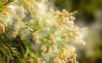
What Is Hay Fever? If you’re allergic to cedar pollen, just watching this video might cause you hay fever symptoms. The video, titled "スギ花粉の飛散 Cedar Pollen Dispersal ( Shot on RED EPIC High-speed )," is a super high-speed video that shows detailed footage of cedar pollen dispersing. It was created by "AQUA Geo Graphic." People with cedar pollen allergies show start to flare up just after watching some yellow cedar pollen be dispersed on TV commercials for anti-allergy medicine. It’s said that there are currently 25 million people with hay fever in Japan. The most common form of hay fever is cedar hay fever, but the number of people who suffer from other types of pollens, such as cypress, ragweed, and birch pollens, has been increasing rapidly, and countermeasures for hay fever are needed throughout the year. Treatment of Hay Fever Photo:A woman blowing her nose Is there any treatment for hay fever, which causes painful attacks every year when the pollen season arrives? In short, the only way to treat hay fever at its root is sublingual immunotherapy for cedar pollen allergies. In this treatment, a weakened cedar pollen pill is placed under the tongue and gradually taken into the body, in an attempt to get the patient’s body used to cedar pollen. The therapy takes more than 2 years and those who have severe hay fever attacks can have them during the treatment, so it’s not an effective cure for all, but it’s more than 60% likely to abate symptoms of cedar hay fever. For other types of pollen allergies, symptomatic treatment with medication or evacuation to pollen-free areas (Hokkaido and Okinawa) is necessary. Regarding anti-allergy drugs, the most effective ones are prescribed drugs, but over-the-counter drugs can be sufficiently effective as well if you act preemptively by using them before the pollen in the air is at its peak. The Causes of Hay Fever Photo:Cedar pollen Cedar pollen is called wind-borne pollen because it's dispersed by the wind. At the start of the video, you can see a large amount of pollen being dispersed by the wind on the branches of a cedar tree. According to the Ministry of Agriculture, Forestry and Fisheries, evergreen coniferous trees (cedar and cypress) are native to Japan, and their straight wood, which is not distorted, is suitable for use as lumber for wooden buildings, so large scale cedar plantations were established to revitalize the forestry industry after World War II, which led to major outbreaks of hay fever. The name "花粉症, kafunsho" ('hay fever' in Japanese), was first coined in October 1963, when the existence of allergic symptoms caused by cedar pollen was identified and presented at the annual meeting of the Japanese Society of Allergology in the fall of that year. The size of cedar pollen is just smaller than a heliozoan and can be seen with the naked eye using an optical microscope. Each cedar flower contains about 400,000 pieces of pollen, so during strong winds, large amounts are dispersed. When Do Hay Fever Symptoms Appear? Photo:Hay fever symptoms The Tokyo Metropolitan Government's Bureau of Public Health has been providing pollen information since 1985, and nowadays, the Japan Meteorological Agency and private meteorological forecasting services provide forecasts for the start of pollen dispersal and pollen distribution throughout the year. You can also check pollen forecasts for plants other than cedar, cypress, and ragweed on the Internet, so if you have hay fever, be sure to stay up to date. Even after December, when peak pollen dispersion has passed, early spring hay fever may come straight after the cold and flus of the year, so be sure to take countermeasures, such as keeping your room humid, ventilate and clean frequently, wash your hands, and gargle. Summary of Cedar Pollen and Hay Fever Cedar pollen allergies, which were once thought to be endemic in Japan, have spread, and are now common worldwide. Tomatoes can also worsen hay fever, so we recommend avoiding them during hay fever season! -
 Video article 3:55
Daisekirinzan - A Place Where You Can Enjoy the Magnificent Nature of Okinawa, Unchanging Since Ancient Times! Leave Behind the Hustle and Bustle of the City on the Famous Trekking Courses!
Nature- 89 plays
- YouTube
Daisekirinzan in Kunigami District, Okinawa Prefecture This video, "Oishi Forest Mountain|A walk in the sky" (大石林山 空中散歩), was created by "Okinawaworld." Daisekirinzan is a mountain in Okinawa's Kunigami District, about a 3-minute drive from Cape Hedo (辺戸岬, hedo-misaki), the northernmost point of the main island of Okinawa. As seen from 0:15 in the video, the island has a karst landscape created by limestone from 250 million years ago. The many strange rock formations and beautiful scenery is reminiscent of Guilin in China, known for its depictions in ink paintings. Nearby is Ashimui (安須杜), which has been a sacred place since ancient times. From Cape Hedo, the mountains seem steep and forbidding, but once you actually enter the mountains, you'll find a peaceful paradise of subtropical flora and fauna. Most of Daisekirinzan is designated as a specially protected area of Yanbaru National Park. You can enjoy the magnificent nature of Yanbaru while making your way through the two main trekking courses. The History of Daisekirinzan Photo:Daisekirinzan, Okinawa Daisekirinzan is a "quasi-national park" in Okinawa, in accordance with the Natural Parks Act. The park is managed with the aim of protecting the beauty of nature and contributing to the health, recuperation, and knowledge of Japanese citizens. On September 15, 2016, along with the official designation of Yanbaru National Park, a part of the area previously designated as Okinawa Kaigan Quasi-National Park was transferred to Yanbaru National Park. Daisekirinzan is a must-visit sightseeing area in Okinawa, even winning the "Tripadvisor Excellence Award 2018" on TripAdvisor for the fifth consecutive year. The Two Main Trekking Courses of Daisekirinzan Photo:Banyan Tree in Oishi Forest Mountain, Okinawa ① Strange Rock / Churaumi Panorama Course As seen from 0:36 in the video, this is a course where you can experience the tropical karst landscape at the northernmost tip of Okinawa. It takes about 60 minutes to complete the 1,200m course. You can see the strange rocks and massive boulders from 0:45 in the video. In addition to strange rocks and boulders, there are also many places of worship, such as the "Stone Forest Wall," which is said to be full of spiritual power. There is also an observation deck where you can enjoy a panoramic view, and during good weather conditions, you can even see Yoron Island (与論島, yoron-to) and Okinoerabu Island (沖永良部島, okinoerabu-jima) in Kagoshima Prefecture (鹿児島県, kagoshima-ken). There is also a barrier-free course, which is 600 meters long and takes about 20 minutes to complete It's designed for the elderly and people in wheelchairs to enjoy. As seen from 2:00 in the video, there's also Eboshi-iwa Rock (鳥帽子岩) towering into the sky, as well as the mysterious Nabe-ike Pond (鍋池). ② Yanbaru Forest Course The Yanbaru Forest Course can be seen from 2:09 in the video. Even in the midst of Daisekirinzan, this is an area where the subtropical trees grow especially densely. It takes about 30 minutes to traverse the 1,000m-long course, and you can enjoy the magnificent natural scenery, including the huge banyan tree seen from 2:32 in the video. Summary of Daisekirinzan Photo:The Phantom Flower Mucuna Macrocarpa, Okinawa In addition to the two famous trekking courses, there are many other sightseeing spots in Daisekirinzan. The Okinawa Stone Culture Museum (沖縄石の文化博物館, okinawa-ishi no bunka hakubutsukan) is a geological and ethnic museum centered around Okinawan stones. Gajumaru Road (ガジュマルロード), also known as the "Path of the Wind" (風の道, kaze no michi) is a road winding along gorgeous scenery. If you're lucky, you might even get the chance to see the rare "Mucuna Macrocarpa," which grows naturally in the mountains of Yanbaru. Even Okinawans rarely come across this "phantom flower." In recent years, Daisekirinzan has been attracting attention as the largest spiritual area in Okinawa. Consider adding Daisekirinzan to your itinerary when you visit Okinawa! 【Official Homepage】Yanbaru National Park Daisekirinzan https://www.sekirinzan.com/en/ 【Tripadvisor】Daisekirinzan https://www.tripadvisor.com/Attraction_Review-g1025649-d1373544-Reviews-Daisekirinzan-Kunigami_son_Kunigami_gun_Okinawa_Prefecture.html -
Video article 3:47
The Caldera of Mt. Aso: A Magnificent Landscape Created by Nature. The Natural Wonderland, Full of Mysterious Scenery, Is Said to Have Been Created by the Gods!
Nature- 784 plays
- YouTube
The Caldera of Mt. Aso This PR video, titled "The Heritage of Tomorrow- God, Nature, and Man," is produced by “N.a” to promote Mt. Aso in Kumamoto Prefecture. The beautiful landscape of Kyushu, including Mt. Aso, can be seen throughout this video. Mt. Aso has a caldera produced by an ancient volcanic eruption, and the people have lived their lives here believing in the power of the gods and nature. A Caldera is a large circular depression in a volcano created from the body of the volcano collapsing. You can see a view of the caldera, billowing with volcanic smoke, in the video at 1:54. The Beautiful Scenery of Mt. Aso Photo:Aso Panorama Line Aso Shrine, known as the Ichinomiya of Higo province (肥後国 : Higono Kuni), and located at the foot of Mt. Aso, is a historic location, considered to be the number one shrine in Higo province. Its origins trace back to mountain and volcano worship in the Jomon period. Legend has it that the god of the shrine, Takeiwatatsumi no Mikoto, once kicked out water from the mountain in order to build a rice field around Mt. Aso. The area around Aso Caldera is designated as a Aso UNESCO Global Geopark. It's a beautiful location where you can learn about the natural landscape. At Aso UNESCO Global Geopark, focused on active caldera, you can see large clouds of smoke climbing high up into the sky. You can also enjoy a view of Aso Geopark in this video. Tourist Spots in the Mt. Aso Area! ©阿蘇市 Modifying Daikanbo (大観峰: Daikanbo) is the highest peak at Aso Kitagairin Zan (阿蘇北外輪山:Aso Kitagairin Zan) in Aso city阿蘇市 : Aso-shi). From the Daikanbo observantory, you can enjoy a spectacular view of the "Five Mountains of Aso" (阿蘇五岳: Aso Gogaku). The Aso Milk Road leading to Daikanbo is great for sightseeing. There's a parking lot and it can be easily accessed, so we definitely recommend checking it out if you have the chance. Some other hidden gems where you can explore the natural scenery of Mt. Aso include Shirakawa Suigen and Kusasenrigahama. Relax in the Hot Springs and Feel the Blessings of Nature! Photo:Kurokawa Hot Springs There are a lot of hot spring facilities around Mt. Aso due to the many volcanoes in the area. One that we recommend visiting is Kurokawa Hot Springs. We especially recommend Aso Farm Land, created with the idea of promoting health. You can enjoy delicious local cuisine and natural hot springs to heal your body after exploring Mt. Aso. Summary of Mt. Aso There are many sightseeing spots where you can experience the beautiful landscape of Mt. Aso. In the video, you can enjoy beautiful views of Mt. Aso with calm music playing in the background. Enjoy the mysterious scenery of Mt. Aso, famous as a land created by the gods. There are many volcanoes in Japan besides Mt. Aso. People have lived in reverence for them since ancient times. We hope to see you at Mt. Aso to enjoy the relaxing hot springs, beautiful scenery, and the spiritual shrines! 【Tripadvisor】Asosan (Takadake) https://www.tripadvisor.com/Attraction_Review-g298212-d320703-Reviews-Mt_Aso-Kumamoto_Prefecture_Kyushu.html -
Video article 2:38
Kujukushima in Nagasaki Has a Total of 208 Islands, and It Contains the Highest Density of Islands in Japan! Check Out the Superb View at the Tenkaiho Observatory!
Nature- 257 plays
- YouTube
Introducing Nagasaki Kujukushima Tenkaiho The video “Kujukushima Tenkaiho 8KHDR(Kujukushima Tenkaiho 九十九島 展海峰 8KHDR),” created by “Japan Explorers,” is a promotional video introducing the popular tourist spot “Kujukushima Tenkaiho,” part of the Saikai National Park in Sasebo, Nagasaki. Kujukushima is easily accessed from Sasebo station, (home to the popular tourist spot “Nagasaki Huis Ten Bosch”) taking only about 30 minutes to reach by car. It's an area of ocean 25 km north of Sasebo Port, dotted with islands. Many people visiting Kujukushima visit Nagasaki's Huis Ten Bosch and vice versa. The scenic view from the Tenkaiho observatory in Kujukushima, is introduced in the video with a famous Japanese song called “Jupiter.” Enjoy the contrast of the green islands and blue ocean as far as the eye can see. The Top 100 Landscapes of Japan - Kujukushima Photo:Tenkaiho rapeseed field Kujukushima is an archipelago located in the north of Nagasaki, 25 km from the west coast of the Kita-Matsuura Peninsula. It contains the highest density of islands in Japan. The word “Kujuku” means 99, but there are actually a total of 208 islands. There are only 4 inhibited islands, and they are: Kuroshima, Takashima, Maejima, and Toudomari. The rest are uninhabited. There are 4 observatories as well. Tenkaiho, Yumiharidake Observatory, Ishidake Observatory, and Kujukushima Hakkei. Tenkaiho is the one introduced in the video. From Tenkaiho, you can enjoy a panoramic view of Kujukushima which is included in the "100 Landscapes of Japan." The most popular view among photographers is of the cruise ship weaving through Kujukushima. It's also great for taking Instagram pictures, and many young adults come here to take photos. You can see the full view of Kujukushima from Tenkaiho in the video. Tenkaiho is also a popular spot for tourists who come to see the flowers. In the spring, rape blossoms are in full bloom and more than 150,000 cosmos bloom in the fall. There are also cherry blossoms and a night view as well. Sightseeing Around Kujukushima's Tenkaiho Photo:Scenery from Ishidake Observatory Among the observation decks, the most popular one for viewing the sunset is the Ishidake Observatory, where the silhouettes of islands floating in the sunset are as beautiful as an ink painting. You can also experience the view from the ocean by cruise ship or on a sailboat. The Kujukushima Pleasure Boat "Pearl Queen" is popular among tourists as you can see the southern islands of Kujukushima up close on a 50 minute cruise. While listening to the explanations of the legends and lore that remain on the island of Kujukushima, you begin to imagine its rocks turning into lions and turtles. On top of that, you can also experience the sunset cruise, where you can see the beautiful sun setting between the islands. There's also Kujukushima Aquarium Umikirara, and the Kujukushima Zoological and Botanical Garden Morikirara at Pearl Sea Resort. At 0:24 in the video, you can see the 2 ships floating in the distance. Sea kayaking, yachting, swimming and other marine sports that take advantage of Kujukushima Island's topography are also popular. From Sasebo Port, where Kujukushima is located, you can also take a ferry to enjoy sightseeing at the Goto Islands. Dining in Kujukushima Photo:Grilled oysters If you're going to Sasebo, you've got to try the Sasebo Burgers and fresh seafood. Kujukushima oysters are a famous winter food as well. In November and February, they hold the Kujukushima Oyster Festival. It's a fun event with 400 grills and endless oysters! Visitors can experience grilling their very own oysters too. Kujukushima rice crackers (from Kujukushima Group CO.,LTD.), Kujukushima Iriko Somen (a type of thin noodles), and Kujukushima puffer-fish, are some of the other popular foods in Kujukushima. A little-known souvenir spot on Kujuku Islands is "Kujukushima Namino Michi," a direct sales outlet on the westernmost tip of the Japanese mainland. It is a very small roadside station, but there are variety of fresh vegetables and sea food. It is a very small roadside station, but you can buy local vegetables and seafood here, as well as enjoy the local gourmet food of Kujukushima. Summary of Kujukushima With it's vast blue seas and incredible islands, it has to be one of the best natural landscapes in the world. The video shows some amazing views, so be sure to check it out if you still haven't yet. If you're looking for a vacation why not stop by Kujukushima? You definitely won't regret it. Sightseeing is also very convenient as there are several hotels around Kujukushima. There's also the Sasebo Convention & Visitors Association which is very useful for travelers. Gather your information beforehand and enjoy your trip to Kujukushima! 【Tripadvisor】Tenkaiho https://www.tripadvisor.com/Attraction_Review-g298217-d1820255-Reviews-Tenkaiho-Sasebo_Nagasaki_Prefecture_Kyushu.html -
Video article 3:18
Watch a video of the mysterious sight of "Fujindo," the largest limestone cave in the Kanto region with a total length of 2.2 km in Tano County, Gunma Prefecture. The spectacular view of stalactites, which take 100 years to grow 1 cm, is also a famous power spot!
Nature- 197 plays
- YouTube
Sightseeing Video Introduction of "Fujindo" Cave, a limestone cave in Tano County, Gunma Prefecture, Japan This video, titled "The Largest Limestone Cave in Kanto!" (関東最大級の鍾乳洞 『不二洞』), shows a fabulous view of the Limestone cave located in Gunma. There are many mysterious limestone caves found throughout Japan. Of all the limestone caves, Fujido Cave, located in Kawawa Nature Park in Ueno-village, Tano District is the largest in the Kanto region, with an astonishing length of 2.2 km. Fujido is designated as a natural monument of Gunma Prefecture. If you explore inside of the Fujido, you're sure to have an extraordinary experience! You can see a number of breathtaking views in the video. Be sure to check it out to see the mysterious Fujido Cave! Fujido Cave Photo:Fujido Cave A limestone cave is a natural cave that is formed over a long period of time by the gradual erosion of limestone rock due to the inflow of underground water. It's said that the Ueno-village area, where Fujido Cave is located, was once covered with a deep virgin forest. Villagers in the area discovered the cave about 1,200 years ago, and since then, the cave has been used as a place for Buddhist training. In the Fujido Cave, the Fujido Yayoi Matsuri (festival) is held every March. Through the festival, people pray for the safety of the Fuji cave, the largest cave in the Kanto region. Highlights of Fujido Cave! Source :YouTube screenshot You can see the exploration of Fujido Cave at 0:38 in the video. At the end of a 120-meter underground tunnel, visitors climb up a 40-meter pit staircase to find a spacious limestone cave. The cave is kept cool throughout the year at a temperature of about 11 degrees Celsius(51.8°F). In the limestone cave, there are a lot of Instagram worthy spots made by nature such as the "Five Colored Clouds" (0:54), "Yama's Staff of Pilgrimage" (1:25), "Dragon King Falls" (1:44), and "Nyoraido" (2:02) and many more. There’s a legend about "Yama’s Staff of Pilgrimage" that says if you make a wish and touch it seven times, your wish will come true. Source :YouTube screenshot Inside of the cave, there are 45 spots named after Buddhist beliefs. At 2:17 in the video, you'll see a sparkling tower made of limestone. This tower, called "Renge-no-To" (Lotus Tower) is the largest stone in the cave. Next, at 2:34 you can see "Hi-no-Hashira" (The Pillar of Flame), and at 2:49 the sacred spot known as "Gohyaku-Rakan." It is said that it takes about 100 years for the limestone to grow 1 cm. Next time you visit Fujido, pay attention to the artistic shape of the cave and try to comprehend the amount of time it took to form. Summary of Fujido Cave, the Largest Cave in the Kanto Region Photo:Fujido Cave A limestone cave is a mysterious phenomenon created by nature. In recent years, the area around the Fujido Cave has become a popular power spot. Inside the cave you can also see the lit-up limestone, as shown in the video. Since the footing in the cave is not very good, we recommend that you wear comfortable clothes and shoes that are easy to get around in. If you're looking to travel to some of Japan's best-kept secrets, come to the mysterious Fujido Cave and experience the beauty of mother nature. Check out the video and feel for yourself the deep history and wonder concealed within the Fujido's limestone walls! ◆Fujido Cave◆ 【Address】665 Kawawa, Ueno-village, Tano Gun, Gunma Prefecture 【Access】35 minutes by car from Shimonita Interchange on the Joshinetsu Expressway 【Hours】9:00 AM - 4:30 PM ※ 9:00 AM 〜 4:00 PM in November, 10:00 AM〜 3:00 PM from December to mid March 【Closures】Open year round 【Average time spent here】About 40 minutes 【Parking】Available 【Telephone】 0274-59-3117 【Entrance fee】Adults 800 yen/Elementary and middle school students 500 yen (※ as of November 2019) -
Video article 11:19
Enjoy a Cup of Pure Bliss in the Great Outdoors! Enjoy an Out-of-the-Ordinary Experience With Coffee Brewed From the Spring Water of Oike Spring in Oita Prefecture
Nature- 35 plays
- YouTube
This video, titled "[Hiking] Coffee From a Spring - A Walk in the Woods and a Quiet Time" (【ハイキング】湧き水でコーヒー - 森林散策と静かな時間), was released by "Morinone Channel" (モリノネチャンネル). Wouldn't it be wonderful to make coffee from a clean spring in the mountains and take in the magnificent scenery? The Oike Spring Group in Yufu City, Oita Prefecture, introduced in the video, is an area at the source of the Aso River. The rainfall on Mt. Kurodake is filtered underground over a long period of time to produce clean spring water. It's very comfortable and cool even in summer as it is located 850 meters above sea level. Sitting under a tree, boiling water from the spring with a portable stove, and drinking coffee will refresh your body and mind. -
Video article 2:09
Spectacular view of lush tea fields and Mt! Fuji, Shizuoka Prefecture, a popular photo spot for foreign tourists!
Nature Travel- 726 plays
- YouTube
Fuji, Fuji City, Shizuoka Prefecture, Japan: Tea Fields at the Foot of Mount Fuji, "Obuchi Sasaba" Video Introduction This video, titled “Drone Shot Tea Plantation and Mt. Fuji Obuchi Sasaba(空撮 茶畑と富士山 静岡 大淵笹場 | Tea Plantation and Mt. Fuji),” is a video using drone footage of a tea plantation around Mt. Fuji in Shizuoka in the Tokai region of Japan. It was produced by "crescendo L DESIGN." The Mt.Fuji area in Shizuoka has two famous tea growing locations called Obuchi Sasaba and Imamiya. Early summer, when the lush tea plantation spreads across the slope on the outskirts of Mt. Fuji and shows natural scenic beauty unique to the famous tea growing locations, is the best time to visit. You can watch drone footage of the tea plantation at Obuchi Sasaba in the video. With Mt. Fuji faintly covered in snow in the background, the vast, solid green tea plantation creates a beautiful landscape unique to Japan. Please watch the video and enjoy the scenic beauty that can only be seen in Japan. How Japanese Tea Is Grown Photo:A Tea Plantation Tea plants grow well in warm weather. In Japan, the largest producers of tea are the Mt. Fuji area in Shizuoka, Uji in Kyoto, and Sayama in Saitama, and teas from these area are called the "Three Famous Teas of Japan." An evergreen tree called camellia sinensis is grown in tea farms nationwide and tea picking is held during May when fresh tea leaves are harvested. The tea is harvested and sold as new tea, so be sure to taste the freshly harvested, elegant flavors. In Shizuoka tea plantations, windmill-like structures are installed to protect the new tea from frost damage in the early spring. Obuchi Sasaba in this video is in Shizuoka Prefecture, which boasts the largest tea cultivation and production area in Japan. Experience Tea Picking on the Outskirts of Mt. Fuji! Photo:Tea picking A popular attraction in tea producing areas, including Obuchi Sasaba in the Shizuoka area, is tea picking. There are also spots where you can borrow a tea-girl costume to pick tea and enjoy a memorable experience. Picking tea in the sprawling tea fields of Obuchi Sasaba, is a great way to remember your trip. We recommend that you buy some delicious tea as a souvenir after a leisurely tour of the tea plantations around Mt. Fuji. When is the best time to visit "Oobuchi Sasaba", a tea plantation and Mt. Don't miss the Oobuchi Tea Festival! Photo:The tea plantation of Obuchi Sasaba Shizuoka Prefecture is known as one of Japan's leading tea-producing regions and there are many tea plantations in the prefecture. In spring, you can see the verdant landscape of tea fields at the foot of Mt. Fuji. The scenery has become so popular among foreign tourists in recent years that you can take a tour of the tea plantations by minibus. The best time to photograph the lush tea fields and Mt. Fuji at Oobuchi Sasaba is from late April to May. We recommend the "Oobuchi Tea Festival," which is held during the best time to view the tea fields. The festival is usually held on May 3, and visitors can enjoy a variety of gourmet foods and events, including a photo session where they can take pictures of tea girls picking tea along with Mt. You're sure to get some great Instagram pics! Summary of Obuchi Sasaba In this video, you can see a spectacular view of the greenery of young tea leaves against the backdrop of Mt. Fuji. After viewing the scenic beauty of Obuchi Sasaba, your everyday tea may be more flavorful. We hope you enjoy your early summer sightseeing trip in the scenic beauty of Shizuoka, where you can experience tea picking, buy delicious tea, and enjoy Japanese tea culture! ◆Obuchi Sasaba◆ 【Address】Near 1516, Obuchi, Fuji City, Shizuoka 【Access】About 35 minutes from JR Fuji Station by bus or about 20 minutes from Tomei Fuji IC/New Tomei New Fuji IC by car 【Parking】Toll parking is available near the tea plantation 【Tripadvisor】Obuchi Sasaba https://www.tripadvisor.en/ShowUserReviews-g303147-d10282623-r377490474-Obuchi_Sasaba-Fuji_Shizuoka_Prefecture_Tokai_Chubu.html -
Video article 7:32
The Graceful Sight of the World-Famous Mount Fuji Can Be Enjoyed From All Over Japan. This Article Will Help You Find a Spot to View Mt. Fuji That’s Just Right for You!
Nature Travel- 365 plays
- YouTube
Introducing the Places to View Mt. Fuji This video, titled "JG☆☆☆☆☆4K Mt.Fuji View Spots You can’t afford to miss" (JG☆☆☆☆☆4K 一度は訪れたい 富士山の絶景ポイント Mt.Fuji View Spots You can't miss) introduces many view spots and tourism spots where you can enjoy the magical scenery of Mount Fuji. Mount Fuji is the tallest mountain in Japan with a height of 3,776 meters above sea level and has been recognized as a World Cultural Heritage site, one of Japan’s Three Great Mountains, and one of Japan’s 100 Finest Soils. As is introduced in the video, you can also observe its grandeur from faraway in the Tokai Region (東海地方,Tokai-chiho) and Kanto Region (関東地方,Kanto Chiho), so why not go out and enjoy the scenery? If you can't go out though, don't worry. We've got you covered with this article. Enjoy the sight of Mount Fuji from various places in Japan through this video. Check out the Best Places to View Mt. Fuji! ©Koichi_Hayakawa Modifying The view of Mount Fuji from Osatsu (相差), Toba City, Mie Prefecture is one location introduced at the beginning of the video. The contrast between the five-storied pagoda of Arakura Fujisengen Shrine and Mount Fuji, which can be seen at 0:22 in the video, is exquisite. This magnificent view is currently the most famous Japanese scenery among foreigners. Many foreign tourists come to Japan to enjoy this view. It truly is the apex of nature. As you can see in the video, there are many popular viewing locations around Mount Fuji such as Lake Kawaguchi (Video 0:49〜), Lake Shoji (Video 1:15〜), Lake Yamanaka (Video 1:23〜), and Oshino Hakkai (Video 1:55〜). The views of Mount Fuji from the Kariyado-Geba Cherry Blossom Tree and Lake Tanuki in Fujinomiya City, Shizuoka Prefecture, are also breathtaking. You can see Mount Fuji up close from Satta Pass (薩埵峠,Satta-toge) in Shimizu Ward, Shizuoka Prefecture and from Miho no Matsubara (三保の松原,Mihonomatsubara), one of Japan’s Three Great Sceneries, as you can see from 3:05 in the video. Fujieda Takizawa: Mount Fuji Over Shizuoka’s Famous Tea Fields! Photo:Night view from Otome Pass Gotenba (Video 3:40〜), Numazu Area (Video 3:54〜), Yamanaka Castle(Video 4:45〜) and Nagahama Castle (Video 4:58〜) are historic places where you can enjoy the beautiful view of Mount Fuji. As you can see in the video, the night view around the foot of Mount Fuji and the view of Mount Fuji from across the sea are nothing less than breathtaking. Ose (Video 5:12〜), Heda Sea (Video 6:04〜), the canola flower fields of Ida (Video 5:58〜), Mount Daruma in Izu City, and Mount Takichi which you can observe from 6:23 in the video are also places where you can view Mount Fuji. At 6:34 in the video, you can see the sight of Mount Fuji from Kyonan Town, Chiba Prefecture, a faraway place. Mount Fuji, which stands in the endless sea with a hat of snow, is said to be the winter scenery that represents Japan. It’s exciting when you can see Mount Fuji from the window of your car or when riding a bus. From 7:08, you can see Mount Fuji from the window of a car on the express lane, a bullet train, and an airplane. At the end of the video at 7:28, you can see a gorgeous view of the contrast between the bright yellow canola flowers and Mount Fuji. The snow around the peak of Mount Fuji is beginning to melt, signaling the arrival of spring. Climbing and Tourist Information About Mount Fuji! Photo:Mount Fuji Many people visit Yamanashi prefecture and Shizuoka prefecture once mountaineering season has started in order to enjoy mountain climbing/hiking or walking around the crater. Please thoroughly check the route and distance to the mountain hut and the camping area, the weather forecast, the time it will take, and information about eruptions before mountaineering. It is also crucial that you check the live camera at the fifth station of Mount Fuji, carry a map, and wear clothes that you can move easily in. You can arrive at the fifth station of Mount Fuji by car, using the Fuji Subaru Line or the Mount Fuji Sky Line. A parking lot is also provided. The mountain paths are Yoshida, Gotenba, Fujinomiya, and the Subashiri Route, but be careful because some of them are closed depending on the season. If you’re going to visit Mount Fuji, be sure to visit the Mount Fuji World Cultural Heritage Center and Kodomo no Kuni! Summary Photo:Mount Fuji and cherry blossoms As is introduced in the video, there are countless spots around Mount Fuji where you can enjoy the graceful scenery of the mountain that it has been revered for. When you visit Mount Fuji, it is important to follow rules, behave respectfully, and avoid trouble. Set out on an adventure to these viewing locations in Shizuoka and Yamanashi prefecture after careful and deliberate preparation. Please enjoy the sight of Mount Fuji, the mountain that shows us different faces depending on the location and season. It is the pride of Japan. 【Official Website】Mount Fuji NET | Information about Mount Fuji https://www.fujisan-net.jp/ 【Tripadvisor】Mount Fuji https://www.tripadvisor.com/Attraction_Review-g298102-d321024-Reviews-Mount_Fuji-Chubu.html -
Video article 3:56
Lake Ozenuma Summer Hiking! Trek Through the Beautiful Daylilies of Lake Ozenuma, a Famous Place for Flowers at Oze National Park in Fukushima, Japan!
Nature Travel- 109 plays
- YouTube
The Daylilies of the Oe wetlands at Lake Ozenuma: Video Introduction This video, titled "Lake Ozenuma in Summer and Hiking Through the Daylilies of Oe Marsh|Daylilies at Lake Ozenuma|A Famous Place for Flowers" (夏の尾瀬沼とニッコウキスゲの大江湿原ハイキング 尾瀬沼のカンゾウ 花の名所 花見頃), was uploaded by "Discover Nippon." Daylilies are a common seasonal flower during summer in Japan, and Oe Marsh is famous for its spectacular view of the flowers. [Video] 0:21 - Oe Marsh The video shows the yellow daylilies swaying in the summer breeze and the beautiful scenery of various highland plants surrounding the marshland and Lake Ozenuma. Be sure to enjoy the beautiful video showing the lush greenery and brilliantly blooming flowers in this 4-minute video. [Video] 0:28 - Highland Plants [Video] 2:07 - Daylilies Oe Marsh – A Popular Attraction at Oze National Park Photo:Daylilies at Oe Marsh Oze National Park is a famous landmark in Japan and is home to Oe Marsh, an attraction known for its beautiful flowers. Oe Marsh lies around the Oe River near the village of Hinoemata, Fukushima and is known for the beautiful daylilies that bloom there. If you go down river, you'll find Lake Ozenuma, which is surrounded by a promenade for visitors to enjoy a relaxing stroll around it. It's an especially popular attraction during the summer months. What Are Daylilies? Facts and Interesting Information About the Famous Flower of Oze National Park Photo:Daylilies The daylilies of Oze National Park are characterized by their dark orange-yellow petals, of which it has six. The best time to see the daylilies at Oze National Park is from late June to August, as they grow at high elevations in the mountains, where temperatures can vary greatly. In Japanese, the daylilies at Oze National Park are called Nikkokisuge (ニッコウキスゲ, 'Nikko Daylilies'), which comes from the fact that there are many colonies of them that can be found growing in Nikko, Tochigi. Other than Oe Marsh, these daylilies can be found at Senjogahara Marshland and in the Kirifuri Highlands of Nikko, Tochigi, where the name originated, as well as in Nagano Prefecture, which is home to the Kirigamine Highlands and Kurumayama Highlands, where the flowers can be found growing in colonies. What makes the flowers so special is the vivid color of their petals. The flower is known to bloom in the morning and close in the evening, and it's almost as if it puts all of its energy into blooming to show you its brilliant beauty. Other Flowers to See at Oe Marsh, a Famous Spot for Flowers in Oze National Park! Photo:Daylilies at Oe Marsh Oe Marsh in Fukushima Prefecture is one of the most famous flower viewing spots in Oze National Park. Oe Marshland is famous for its flowers in summer, but there's a lot more to see than daylilies. Here we'll introduce the best time to view the different flowers around the Oe River from spring to summer, together with the meanings of each flower in Japanese culture. Daylilies A short-lived flower that blooms in the morning and withers in the evening. The bright color of the flower is its distinguishing feature. Best time to see it: Mid-July to late July Language of Flowers: Something new each day Photo:Skunk cabbage Skunk Cabbage At first glance, skunk cabbage looks like a large white flower, but the white part is actually not a petal, but rather a type of leaf called a bract. The white leaves have a strong presence, and the stick-like part of the leaf is surrounded by a flower that looks like an ear. It's popular for its dignified appearance. Best time to see it: Mid-May to early June Language of Flowers: Beautiful memories Photo:Cottongrass at Lake Ozenuma Hare's-Tail Cottongrass In June, small yellow petals bloom from this flower, and by the end of June, they turn into fluffy, white, round heads. The lovely cotton grass blooms all over Oze National Park. Best time to see it: Late June to mid-July Language of Flowers: Wavering thoughts ※The above information is based on the usual flower viewing times for Oze National Park as a whole. The blooming time and best time to see the flowers may vary with the climate of a given year and the altitude of the area the flower is growing, so please view this information only as a reference, not as a guarantee. Let's Go Hiking in Oze – Lake Ozenuma to Oe Marsh: A Walking Course Recommendation for Enjoying the Splendid Scenery of Oze National Park Photo:Lake Ozenuma hiking trails Oze National Park, which boasts a vast area, has a number of hiking courses, some of which are quite advanced and will require an overnight stay at a mountain lodge. We recommend a one-day course that begins at Numayama Pass on the Fukushima Prefecture side of the mountain, passes through Oe Marsh, and returns to Numayama Pass after stopping at Lake Ozenuma. It's a 4.35-mile hike, and the wooden boardwalk is well maintained, making it ideal for hiking beginners and those who want to enjoy a casual hike to see the views in Oze National Park. Oze National Park Day Trip Hiking Course Numayama Pass → Oe Marsh → Lake Ozenuma → Oe Marsh → Numayama Pass Near Lake Ozenuma, there is a famous photo spot as well as the Ozenuma Visitor Center where you can get information about the nature of Lake Ozenuma and Oze National Park by experts on the area. How to Get to Oze National Park From Tokyo How you decide to travel to Oze National Park will depend on which hiking course you plan on using. For the hiking course we listed above, the best way to reach Numayama Pass is as follows. Take the train from Tokyo Station to Aizukogen-Ozeguchi Station (210 mins), then take a bus to Numayama Pass (120 mins). This route will take about 6 hours in total and there will be a couple transfers depending on the line you use. Most trains will take you to Kitasenju Station and from there will be a straight shot to Aizukogen-Ozeguchi Station via the Tobu Line's Limited Express Revaty. Oze National Park From Tokyo Station Tokyo Station → Aizukogen-Ozeguchi Station → Numayama Pass ※The bus from Aizukogen-Ozeguchi Station to Numayama Pass is not in operation from November to March. ※Oike to Numayama Pass is closed from November to mid-May. If you're hiking at a trail starting at Hatomachi Pass or Oshimizu, you can use one of the two following routes. Take the shinkansen from Tokyo station to Jomo Kogen Station (60 mins), and from there take a bus to Togura (戸倉) (120 mins), and from Togura, take a bus to Hatomachi Pass (25 mins). Tokyo Station → Kogen Station → Togura → Hatomachi Pass ※The bus from Togura to Hatomachi Pass is not in operation from November to April. Take the shinkansen from Tokyo station to Jomo Kogen Station (60 mins), and from there take a bus to Togura (戸倉) (120 mins), and from Togura, take a bus to Oshimizu (20 mins). Tokyo Station → Kogen Station → Togura → Oshimizu ※The bus from Togura to Oshimizu is not in operation from November to April. Summary of Summer at Lake Ozenuma and Oe Marsh Currently, there are more than 900 species of alpine plants that inhabit Oze National Park, making it a very unique place to visit in Japan. In order to protect the scenery of Oze National Park, we ask that you please do not leave trash behind or step foot into the wetland area. In the summer, vast mountains and lovely flowers await you in Oze National Park. Whether you're a serious climber or visiting for a casual nature walk, be sure to stop visit! 【TripAdvisor】Oe Marsh -
Video article 1:28
Sasaguri Kyudai Forest – Like Something You'd See in a Ghibli Movie! Discover One of the Most Scenic Spots in Fukuoka Prefecture, Plus Access Information and More!
Nature Travel- 434 plays
- YouTube
The Bald Cypresses of Sasaguri Kyudai Forest: Video Introduction This video, titled "Giant Conical Trees in a Pond "Bald Cypresses" in Sasaguri, Fukuoka" (view 池に浮かぶ円錐の巨木 福岡県篠栗町の「ラクウショウ」), was uploaded by "SankeiNews." Sasaguri Kyudai Forest is located at the western edge of the Kyushu University Forest in Sasaguri, Fukuoka, in Japan's Kyushu Region. Approximately 50 species of evergreen broad-leaved trees and 40 species of deciduous broad-leaved trees grow in this lush 42-acre forest. The mysterious beauty of the bald cypresses floating on the surface of the water in Sasaguri Kyudai Forest has become a hot topic in Japan, attracting a constant stream of visitors from all across the country. Please take a look at the video below to see the mystical view of Sasaguri Kyudai Forest created by the bald cypresses. [Video] 0:37 - Sasaguri Kyudai Forest An Introduction to Kyushu University Kyushu University, often abbreviated to "Kyudai," is a Japanese university in Fukuoka Prefecture. It is one of the top universities in Japan according to various sources, including the Times Higher Education Japan University Rankings, where it currently ranks 6th. While most courses at Kyushu University are taught in Japanese and will require a JLPT N1 certificate to qualify for, the university also teaches a number of courses in English, and accepts students with an IELTS score of 6.0 or greater. In order to study abroad at Kyushu University, you must be enrolled as a degree student at one of Kyushu University's partner institutions, and be nominated by your home university as a candidate. Kyushu University's graduate school programs have differing requirements in each department, but enrolling in graduate school at Kyushu University requires students pass an entrance exam that is regarded as one of the most difficult in Japan. What is Sasaguri Kyudai Forest? Photo:Sasaguri Kyudai Forest, Sasaguri, Fukuoka Sasaguri Kyudai Forest is located at the western edge of Kyushu University Forest in Sasaguri, Fukuoka, and is jointly managed and operated by Kyushu University and the town of Sasaguri. There is also a walking trail and the area has been open to the public since 2010. The vast 42-acre Sasaguri Kyudai Forest is home to about 50 species of evergreen broad-leaved trees, including itajii and Japanese blue oaks, and around 40 species of deciduous broad-leaved trees, including jolcham oaks and Japanese wax trees. The most eye-catching of all are the giant bald cypress trees. More than a dozen conical trunks can be seen standing in a corner of Kamata Pond. The bald cypress is characterized by its aerial roots. The aerial roots protruding from the ground supply oxygen to the submerged roots. In Japanese, the bald cypress is called "Rakusho" (ラクウショウ), but another name for the tree, which is native to North America, is "numasugi" meaning "swamp cedar." As this name suggests, it prefers places such as swamps and wetlands. The bald cypresses at Sasaguri Kyudai Forest were planted from seedlings in 1977 by Kyushu University to study the tree. The trees are currently around 20 meters tall, but can grow as tall as 40 meters in their natural habitat. The tree's appearance also changes with the seasons, with bright green leaves in the summer and autumn colors in the fall. There's a 2km-long promenade around Kamata Pond in the center of Sasaguri Kyudai Forest, which has been certified as a "forest therapy base" by the Forestry Agency of Japan for its pleasant atmosphere which is great for forest bathing. The Habitat and Characteristics of the Bald Cypress, and How It Differs From the Dawn Redwood Photo:Dawn redwoods The bald cypress is a deciduous coniferous tree of the cypress family (Cupressaceae) native to North America. The name bald cypress comes from their historical tendency to be among the first trees in the American South to lose their leaves in the fall. The bald cypress is characterized by its ability to grow in swampy areas, as evidenced by its other name, "numasugi" (ヌマスギ, lit "swamp cedar"). Another characteristic of the bald cypress, which grows very fast, is that when it becomes an old tree, it grows aerial roots that serve to supply oxygen to its submerged roots. The bald cypress is easily mistaken for the dawn redwood, which has a similar leaf shape, but the difference is obvious when looking at the way the leaves are attached. The bald cypress' leaves are attached to the branches in opposite directions, while the dawn redwood's leaves are attached to the same part of the branch in pairs. [Video] 0:42 - The Roots of the Bald Cypress The Waterfront Forest at Sasaguri Kyudai Forest + the Best Times to See the Bald Cypresses Photo:Bald cypresses at Sasaguri Kyudai Forest, Sasaguri, Fukuoka The 2km-long promenade around Kamata Pond at Sasaguri Kyudai Forest is dotted with attractions, including five plazas. Among them, the Waterfront Forest offers a mysterious view that makes you feel as if you have wandered into the world of Ghibli, and has become a popular spot on Japanese Instagram. This spectacular view can be seen when the water level of Kamata Pond is high. The best time to see the water level rise is from early spring to around the end of Japan's rainy season (June-mid-July). In contrast, the water level is low from summer to fall, but during this period, you can see the aerial roots of the bald cypresses. The best time to see the autumn leaves is mid-November, when the falling leaves decorate the area around the trees in place of the water. Sasaguri Kyudai Forest – Directions and Nearest Station Here is how to get to Sasaguri Kyudai Forest. If you go by train, the nearest station is Kadomatsu Station. Take the JR Fukuhoku Yutaka Line rapid train bound for Nogata at Hakata Station (platform 8), get off at Kadomatsu Station, and take a taxi to the Sasaguri Kyudai Forest south exit parking lot (篠栗九大の森南口駐車場, Sasaguri Kyudai no Mori Minami-guchi Chushajo), which takes about 10 minutes. The train ride from Hakata Station takes about 17 minutes, or 4 stops if you take the rapid train. The fare is 280 yen. If you take a bus, the nearest station is Kasuya Police Station. Take a highway bus bound for "Iizuka/Tagawa" from Tenjin Expressway BT bus stop #1 and get off at "Kasuya Keisatsu Sho-mae" (粕谷警察署前). Go straight for about 300m east on the sidewalk with the bus stop, turn left and keep going straight until you see the information board for "Sasaguri Kyudai Forest", follow the sign and you will arrive at Sasaguri Kyudai Forest in about 15 minutes on foot from "Kasuya Keisatsu Sho-mae". The bus ride from Tenjin to "Kasuya Keisatsu Sho-mae" takes about 35 minutes and costs 510 yen. If you're going by car, the shortest route to the waterfront forest is via the "North Exit Parking Lot." Directions are as follows: Exit the expressway at the "Fukuoka IC" and go straight for about 2 km in the direction of Iizuka (飯塚). Then turn left at the "Wadabashi Signal," go about 50m, turn left again, go straight for about 300m, then turn right and go uphill. Continue straight and you will arrive at the South Exit Parking Lot of Sasaguri Kyudai Forest. Go straight for about 200m from the South Exit Parking Lot, then turn right and walk about 300m through the forest to reach the North Exit Parking Lot. Although you can get there by car, we recommend using public transportation to avoid traffic congestion caused by the increase in the number of tourists to Sasaguri Kyudai Forest. Summary of the Bald Cypresess of Sasaguri Kyudai Forest Sasaguri Kyudai Forest is a photogenic spot that is rapidly gaining popularity. However, it's become so popular that many tourists visit the forest. As a result, the forest is experiencing problems, such as traffic congestion, and destruction of the forest due to violations of etiquette, such as barbecuing, littering, and taking photos in restricted areas. They've even considered closing the area to allow the forest to recover.... To prevent this from happening, please follow the rules and manners, and enjoy the cypresses of Sasaguri Kyudai Forest, one of the best healing spaces in Fukuoka. [TripAdvisor] Sasaguri Kyudai Forest -
Video article 6:52
Video of "Heisenji Hakusan Shrine" in Katsuyama City, Fukui Prefecture, known as a moss temple, and its mysterious appearance is a sanctuary itself! What is the best time to see the beautiful green moss and its charm?
Nature Travel Art & Architecture- 372 plays
- YouTube
Video introduction of "Heisenji Hakusan Shrine" in Katsuyama City, Fukui Prefecture This video, titled "【Fukui/Famous Tourist Attractions】Heisenji Hakusan Shrine - A Temple Covered in Moss - Heisenji Hakusan Shrine in FUKUI, JAPAN -" (【福井/観光名所】平泉寺白山神社/青苔が広がる苔の宮 - Heisenji Hakusan Jinja in FUKUI, JAPAN -), was uploaded by "channel WASABI." This video shows you the charms and history of Heisenji Hakusan Shrine with a video tour through its moss-covered cobblestone paths. Please enjoy the 7-minute video showing the solemn atmosphere of Heisenji Hakusan Shrine. Heisenji Hakusan Shrine: The History of the Shrine & the Deities Worshipped There Photo:Heisenji Hakusan Shrine, Katsuyama, Fukui Heisenji Hakusan Shrine is located in Katsuyama, Fukui, in Japan's Koshinetsu region. Its history dates back to 717 AD, during the Nara Period (710-794 AD). The shrine is the predecessor of Heisenji Temple and was founded by the monk Taicho Taishi. Later, it became a branch temple of Enryakuji Temple on Mt. Hieizan, and as the base of mountain worship in the Echizen Province, it boasted such prosperity that it had 48 shrines, 36 halls, and 6,000 monasteries. However, it was burned down during a civil rebellion in the Sengoku Period (1467-1615 AD). Moreover, Heisenji was banned during the Meiji Period as part of an order to separate Shintoism and Buddhism. Later, Hakusan Shrine was built on the site and became the current "Heisenji Hakusan Shrine." Located within the specially designated Hakusan National Park area, the site is a well-known tourist attraction in Fukui Prefecture, and is designated as a National Historic Site under "Former Precincts of Hakusan Heisenji Temple." Heisenji Hakusan Shrine is dedicated to the oldest goddess of well-being for couples, Izanami no Mikoto. In Japanese mythology, she is the creator of the Japanese continent and other gods in Japan and is considered the greatest god among them. It is believed that she blesses the well-being of couples, families, and future generations. In this vast area, many ruins have been discovered, though only a few have been studied. As researchers dig deeper, they discover more and more artifacts, such as cobbles and items from the schools of monks from medieval Japan. It's believed that there are still many more hidden treasures beneath the ground. The Best Seasons to Visit to See the Beautiful Mossy Temple Photo:Heisenji Hakusan Shrine, Katsuyama, Fukui Heisenji Hakusan Shrine is famous as a moss temple. From the cedar grove, to the boundary stones along the approach to the shrine, to the stone pavement leading to the hall of worship, the spacious shrine grounds are covered in beautiful green moss. The best time to view the approximately 100 varieties of moss is during Japan's rainy season from June to July. During this season, when the mosses are even more beautiful, it can feel as if you've wandered into another world. Spring brings fresh greenery, while in early summer the heavenly water-laden mosses shine even brighter. Autumn brings colorful foliage, and winter brings snowy landscapes. The contrast of the four seasons at Heisenji Hakusan Shrine is so incredible that it's hard to believe such beauty was created by nature. Heisenji Hakusan Shrine is the northern center of worship for Mt. Hakusan and is a popular power spot. If someone is available at the shrine office, have a goshuin stamp put directly into your stamp book if you're collecting them. Beautiful Echizen washi (Japanese paper) is used for the goshuin stamps. Attractions at Heisenji Hakusan Shrine Photo:Heisenji Hakusan Shrine, Katsuyama, Fukui There is much more to see at Heisenji Hakusan Shrine than just moss, and while the time required for a visit varies depending on how you choose to tour the grounds, it generally takes between 30 minutes and 2 hours. You can request a guide up to 7 days in advance, so you can plan your visit in accordance with your travel itinerary. Here are some of the highlights of the shrine. The Cobblestone Paths Leading to the Garden The cobblestone paths at Heisenji Hakusan Shrine are included in the list of Top 100 Roads in Japan. It's said that about 1,000 years ago, ascetic monks carried stones from the Kuzuryu River to make them. [Video] 0:30 - The Cobblestone Path Leading to the First Torii Gate The Second Torii Gate The second torii gate of Heisenji Hakusan Shrine has quietly watched years of history unfold before its eyes, with visitors such as Minamoto no Yoshinaka praying for victory in battle, or Minamoto no Yoshitsune and Benkei passing through the gates. The second torii gate also has an unusual shape with a roof over it. Mitarashi Pond This spring was discovered by the great Buddhist monk Taicho Daishi on his way to Mt. Hakusan. Legend says that a goddess appeared before him and instructed him to ascend to Mt Hakusan. [Video] 1:48 - Mitarashi Pond Surrounded by Dense Greenery The Giant Cedar of Wakamiya Hachiman Near Wakamiya Hachiman is a massive, majestic 450-year-old cedar tree. It is one of the seven cedars that survived the burning of Heisenji Hakusan Shrine during the Sengoku Period. The Main Shrine Pavilion of Heisenji Hakusan Shrine In 1795 AD during the Edo Period (1603-1868), Shigetomi Matsudaira, the samurai in charge of the Echizen province (today known as northern Fukui Prefecture), rebuilt the main pavilion of Heisenji Hakusan Shrine. The door of this shrine opens only once every 33 years, and the next time the door is scheduled to open is in 2025. On the door, there are spectacular sculptures of mythical creatures, including Kirin and Dragons. The best way to get to Heisenji Hakusan Shrine is by car. It has a parking lot that can accommodate 30 standard vehicles and it costs 300 yen to park, in order to fund maintenance of the historical landmark. Things to Do Near Heisenji Hakusan Shrine Heisenji Hakusan Shrine is located a short distance from the city of Katsuyama, where there are a number of things to see and do. Below we'll introduce a few of them. Echizen Daibutsu A 17-meter-tall Buddha statue. Taller than the Great Buddha of Nara at Todaiji Temple, it features 2 smaller Buddhist statues on each side of it, and Seidaiji Temple, where the Echizen Daibutsu is located, houses 1,281 Buddha statues. The temple is also home to a 5-story pagoda. Hours: 8:00 am - 5:00 pm (9:00 am - 4:00 pm during winter) Admission Fee: Adults: 500 yen, Elementary, middle, and high school students: 300 yen. Discounts are available for groups of 15 or more. Katsuyama Castle Museum Katsuyama Castle was built during the Warring States Period (1467-1615 AD) in present-day Katsuyama, Fukui. During the Edo period (1603-1867), it was used as the headquarters of the Katsuyama Clan. The castle museum features swords, guns, armor, etc., with hundreds of years of history to explore. Hours: 9:30 am - 4:30 pm (Admission until 4:00 pm). Closed on Wednesdays Admission Fee: Adults: 700 yen, Children (Elementary, middle, and high school students): 280 yen. Discounts available for groups of 20 or more. Yume Ole Katsuyama Textile Factory Memorial Hall Once a textile factory, the building was repurposed into a museum and now acts as a place where visitors can learn about spinning and weaving machines and techniques used in the past. There are also hands-on experiences available where visitors can make their own coasters, etc. from silkworm cocoons. Hours: 9 :00 am - 5:00 pm. Closed on Wednesdays (If Wednesday is a holiday, closed the following day). Admission Fee: General admission: Free. Hand weaving coaster experience: 600 yen. Hand-woven hemp yarn coaster experience: 800 yen. Mayu dama (cocoon ball) craft experience: 600 yen. High loom weaving experience: 1,500 yen Fukui Prefectural Dinosaur Museum As one of the leading dinosaur museums in the world, the Fukui Prefectural Dinosaur Museum is filled with a variety of dinosaur skeletons and fossils of plants and animals, and also features animatronic robots showing how the dinosaurs would have moved. Hours: 9:00 am - 5:00 pm (Admission until 4:30 pm) Admission Fee: Adults: 730 yen, High school and college students: 420 yen, Elementary school and middle school students: 260 yen, Young children and seniors: Free. Discounts are available for groups of 30 or more. Summary of Heisenji Hakusan Shrine The dense trees, carpets of moss, and cobblestone approaches steeped in history make Heisenji Hakusan Shrine a one-of-a-kind tourist attraction. Enjoy a trip to the mystical shrine and experience the slow flow of time. There are many nearby tourist attractions in the surrounding area to check out as well. Stay at a hotel and enjoy the charms of Fukui to your heart's content! 【TripAdvisor】Heisenji Hakusan Shrine -
Video article 3:25
Sightseeing video of Tashirodaira Marsh, Aomori City, Aomori Prefecture! The contrast between cotton grass and the Milky Way is beautiful! Take a trip to taste the charm of the oldest marshland in the Hakkouda mountain range!
Nature Travel- 148 plays
- YouTube
Tashirodaira Marsh, Aomori City, Aomori Prefecture, Japan Video Introduction This video, titled "Time Lapse #129|Mt. Hakkoda|Tashirotai Marsh|A Marsh of Rhododendrons and Cottongrass|4K" (Time Lapse #129 Mt.Hakkoda Tashirotai ツツジとワタスゲの湿原 八甲田・田代平 4K), was uploaded by "aomorigonta." Tashirotai Marsh is a high-elevation marsh located in Aomori City, Aomori Prefecture, in Japan's Tohoku region. The video shows the beautifully blooming cottongrass and azaleas in early summer, as well as the beautiful Milky Way in the night sky, and other breathtaking views that are sure to captivate. Be sure to check it out before reading along. Tashirotai Marsh – Discover the Beautiful, Natural Scenery of Aomori, Japan Photo:Ryujin-numa at Tashirotai Onsen Tashirotai Marsh is located at the northern end of Towada-Hachimantai National Park in Aomori City, Aomori Prefecture, and is a high-elevation marsh designated as a Natural Monument. Tashirotai Marsh was formed from a caldera lake that was created by volcanic activity in the Hakkoda Mountain Range approximately 2 million years ago, and is located at a relatively low elevation at 560 meters above sea level. Furthermore, Tashirotai Marsh is the largest and oldest of all the marshlands in the Hakkoda mountain range. Ryujin-numa (Ryujin Marsh), located at the entrance to Tashirotai Marsh, is filled with emerald green water, and its mysterious scenery has made it a popular spot among both tourists and the people of Aomori Prefecture. Tashirotai Marsh – Autumn Leaves & Other Seasonal Views Photo:Rhododendrons in the Hakkoda Mountains, Aomori A variety of alpine plants can be seen in Tashirotai Marsh, and from June to July, cottongrass and azaleas bloom, providing beautiful scenery. In summer, zenteika and eleorchis bloom, and the yellow flowers of kinkoka are especially popular. The yellow flowers bloom all over the area and are a must-see, especially if you're a photographer or instagrammer. From late September to mid-October, it's a popular spot for tourists to view the colorful autumn leaves, and the entire marshland changes to a golden hue, fascinating visitors. Tashirotai Marsh has a 1,600-meter-long walking trail that takes about one hour to complete. Visitors can enjoy the beautiful nature and fresh air in the summer and fall. The Tashirotai Marshland Course – Journey Through Nature in the Hakkoda Mountains Photo:Autumn leaves at Tashirotai Onsen, Hakkoda Mountains The Tashirotai Marshland Course is a recommended way to enjoy the nature of the Hakkoda Mountain Range, and starts from Aomori City. Driving along the driving route through the foot of the majestic Hakkoda Mountains, visitors can enjoy viewing the marshlands scattered throughout the Hakkoda Mountain Range. During the summer, visitors can enjoy the blooming flowers and the greenery of the Hakkoda Mountain Range, and in the fall, the autumn leaves add color and beauty to the natural scenery. It's a course we definitely recommend trying if you have the chance. The highlight of the Tashirotai Marshland Course is the natural beauty of the marshland, which changes with the seasons. Tashirotai Marsh is a diverse wetland with a variety of aquatic plants and offers a wide range of natural attractions, from alpine flora to the mysterious marshes created by the melting snow of the Hakkoda Mountains. There are also a number of delicious restaurants and footbaths along the driving route. The course is 88.2 km long and takes 3 hours and 38 minutes to complete. We urge you to visit Aomori and take your time to enjoy the seasonal natural beauty of the Hakkoda Mountains. Summary of Tashirotai Marsh Around Tashirotai Marsh, you'll find Hakkoda Onsen, where you can relax in hot springs after a long day of hiking/walking. There's also lodging facilities, such as the Hakkoda Hotel, so if you like the outdoors, consider planning a trip to enjoy the natural beauty of the Hakkoda Mountain Range. Before visiting, you can also check live cameras that provide video of Aomori Prefecture Route 40 (青森県道40号線, Aomori Kendo Yon-juu Go-sen) to see the weather and traffic conditions. Parking is available for those coming by car. When sightseeing in Aomori, consider stopping by Tashirotai Marsh to experience the natural attractions of the Hakkoda Mountain Range. 【TripAdvisor】Tashirotai Marsh https://www.tripadvisor.com/Attraction_Review-g298241-d1721841-Reviews-Tashirotai_Wetland-Aomori_Aomori_Prefecture_Tohoku.html -
Video article 24:24
Rock Climbing on Mt. Oku-Hotaka! The Breathtaking View From the Peak of the Mountain in Nagano and Gifu Prefectures Will Change How You View the World!
Nature- 377 plays
- YouTube
Introducing a round-trip mountain climbing video from Okuhotaka to Uma no Uma no Uta, spanning Nagano and Gifu Prefectures. This video, titled "Mt. Oku-Hotaka to Gendarmes|Route Change After a Rockslide|Video of a Detailed Round Trip of Uma no Se" (奥穂高からジャンダルム 滑落みて馬の背ピストンへ変更 馬の背詳細往復動画), was uploaded by "Biryu Jr." Mt. Oku-Hotaka Photo:The Hotaka mountain range from Mt. Norikura Mt. Oku-Hotaka is the main mountain of the Hotaka Mountain Range, which straddles Nagano and Gifu prefectures in the Hida Mountain Range of Chubu-Sangaku National Park in the southern part of Japan's Northern Alps. At 3,190 meters above sea level, it is the highest peak in the Northern Alps and the third highest in Japan after Mt. Fuji and Mt. Kita. Mt. Oku-Hotaka (奥穂高岳), Mt. Karasawa (涸沢岳), Kita-Hotaka (北穂高岳), Mae-Hotaka (前穂高岳), Nishi-Hotaka (西穂高岳), and Mt. Myojin (明神岳), are collectively referred to as Mt. Hotaka. It is said that the origin of the mountain's name comes from a legend that a god named Hotakami-no-Mikoto descended to the summit of Mt. Oku-Hotaka. Even today, the mountain is revered as a sacred mountain by local people, who visit and climb it to pray. The first person to summit Mt. Oku-Hotaka was surveyor Gunji Abe in 1906. With its challenging routes, powerful rocky ridges, and panoramic views from the ridge, Mt. Hotaka continues to attract many climbers to this day. The Geological Features of Mt. Oku-Hotaka Here, we'll take a look at the geological features of Mt. Oku-Hotaka ・Volcanic Terrain Mt. Hotaka, including Mt. Oku-Hotaka, is formed mainly of dacitic ignimbrite called "Hotaka andesite." This rock was formed by pyroclastic flows during an eruption approximately 1.75 million years ago, and was uplifted 2,000m over a period of 1 million years after a large-scale eruption. ・Glacial Landforms Many glacial landforms have been observed on Mount Hotaka. Glacial landforms are landforms created by glaciers that have accumulated soil, sand, rocks, etc., while carving away the land below. Mt. Oku-Hotaka – Uma no Se Photo:Uma no Se on Mt. Oku-Hotaka Mt. Okuhotaka, a famous mountain climbing spot, has a narrow ridge called "Uma no Se" (horse's back), which is steep and features cliffs on both sides. Because of how steep it is, it's also a dangerous place where falling accidents occur frequently. The slopes, which look like a combination of rubble, require extreme caution in order to prevent accidents. In the video, you can see how they decide not go to Gendarme (a rocky summit between Mt. Oku-Hotaka and Mt. Nishi-Hotaka), and instead decide to descend via Uma no Se. It's as realistic as if you were there yourself. The sound of the wind, the hands gripping the rocks, the shadows of climbers moving toward the spectacular views... the power of these scenes draws you in. [Video] 5:44 - Advancing Along Uma no Se Mt. Oku-Hotaka – Routes and Difficulties Here are the routes of Mt. Oku-Hotaka according to difficulty level: ・Kamikochi Course (上高地コース) - The recommended route for beginners Starting from Kamikochi Bus Center, the most common route is [Myojin (明神) - Tokusawa (徳沢) - Yoko (横尾) - Hontanibashi (本谷橋) - Karasawa (涸沢) - Mt. Hotaka Hut (穂高岳山荘, Hotakadake Sanso), Mt. Oku-Hotaka]. Your itinerary should be arranged according to your physical fitness. It is common to stay overnight during the climb. ・Kenkyakusha-Muke Course (健脚者向けコース) The rough route is [Shin Hotaka Onsen (新穂高温泉) - Shirade Hut Ruins (白出小屋跡) - Mt. Hotaka Hut (穂高岳山荘), Mt. Oku-Hotaka]. The trailhead is at Shin Hotaka Onsen. Since there are some points on the ascent where it's easy to make a mistake on the route, it's recommended that you be accompanied by an experienced climber. Furthermore, since route conditions change according to lingering snowfall, it's necessary to check trail conditions ahead of time. ・Advanced Climbing Course (熟練・上級者向けコース) The rough route is [Kamikochi Bus Terminal (上高地バスターミナル) - Yoko (横尾) - Yarisawa Lodge (槍沢ロッジ) - Kakusei Hutte (殺生ヒュッテ) - Yarigatake Hut (槍ヶ岳山荘) - Minamidake Hut (南岳小屋) - Kitahotaka Hut - Mt. Kitahotaka Hut (北穂高小屋) - Karasawa Hut (涸沢岳) - Mt. Hotaka Hut (穂高岳山荘)]. The ridge course from Yarigatake continues through rocky terrain with considerable height differences. Normally, three nights are required for this route, and extreme caution is needed as there are many steep sections. Summary of Mt. Oku-Hotaka Photo:Mt. Oku-Hotaka In this article. we introduced one of the three tallest peaks in Japan, Mt. Oku-Hotaka, and Uma no Se. Although there are dangers, such as slips and falling rocks, Mt. Oku-Hotaka is a thrilling mountaineering experience that features spectacular views of nature that attracts many climbers. Although the climb is not without its dangers, the view from the summit and the thrill of climbing over Uma no Se is said to be exceptional. If you wish to take on this challenge, please do your research and go fully prepared. That being said, if you're just here to enjoy some of the views, hopefully the video is enough for you. 【TripAdvisor】Mt. Oku-Hotaka https://www.tripadvisor.com/Attraction_Review-g298102-d7242442-Reviews-Mt_Okuhotaka-Chubu.html -
Video article 3:11
Experience the Beauty of Kikuchi Valley! Enjoy Clear Streams in the Nature of Kumamoto!
Nature Travel- 472 plays
- YouTube
Kikuchi Valley Video Introduction This video, titled "[4K UHD] Kikuchi Valley in Summer (Kikuchi, Kumamoto)" ([ 4K UHD ] 夏の菊池渓谷(熊本県菊池市)Kikuchi Valley in Summer), was uploaded by "AQUA Geo Graphic." Kikuchi Valley is a nature-rich valley located at the source of the Kikuchi River in Kumamoto Prefecture, and is widely known as a spot where visitors can enjoy its spectacular seasonal scenery. It is also a popular tourist spot for people of all ages, as visitors can enjoy various activities such as kayaking. Check out the beautiful images of Kikuchi Valley. Kikuchi Valley - One of the Most Beautiful Valleys in Kumamoto Photo:Aso-Kuju National Park Kikuchi Valley is known as a "forest of relaxation" stretching from Kikuchi to Aso in Kumamoto Prefecture. The Kikuchi Valley area is covered with primeval forests of firs and zelkova trees, and has been designated as a special recreation area in Aso-Kuju National Park. In addition, the Kikuchi Riverhead has been selected as one of the Top 100 Water Sources in Japan. Kikuchi Valley has many attractions, and waterfalls of various sizes. Reimei Falls around Ryugabuchi, Tengu Falls, and Yonjusanman Falls, selected as one of the Top 100 Waterfalls in Japan, are popular tourist attractions. In addition, Kikuchi Valley is so rich in nature that it has been selected as one of the Top 100 Forests for Forest Bathing and the Top 100 Nature Spots in Kumamoto because of the natural environment. Therefore, visitors are required to pay a maintenance fee to preserve the environment. From Cherry Blossoms to Autumn Leaves – Seasonal Highlights of Kikuchi Valley Photo:Autumn leaves in Kikuchi Valley Kikuchi Valley is known as a summer resort and is a place to cool off naturally. One of the highlights of the valley is that it is comfortable even in the hot Japanese summer, and visitors can enjoy a pleasant stroll in the great outdoors. There are two walking courses: a 1-km round-trip "Healing Course" and a 2-km round-trip "Negative Ion Enjoyment Course." The courses allow visitors to naturally detox their minds while enjoying the surrounding scenery. In spring, visitors can enjoy cherry blossoms at the Kikuchi Valley Rest Plaza, in fall, the autumn leaves begin to change color around the end of October, and in winter, the misty ice flowers bloom. Kikuchi Valley, with its beautiful and spectacular scenery throughout Japan's four seasons, offers plenty to see! The photogenic scenery is popular among photographers, instagrammers, and young people alike. Mizunoeki Pleasure Park - An Exciting Park for Families You might be worried that small children won't be able to have fun in a place with so much nature. For families, we recommend Mizunoeki Pleasure Park, located near the Kikuchi River flowing from Kikuchi Valley. Here, visitors can enjoy a variety of athletic activities, including BMX, and bouldering, and even go fishing in the fishing pond. After playing at Mizunoeki Pleasure Park, don't forget to take in the beautiful nature of Kikuchi Valley. Summary of Kikuchi Valley in Kumamoto, Japan Did you watch the video of Kikuchi Valley in summer, with its beautiful scenery and the soothing sound of flowing water? Camping and barbecues are prohibited in Kikuchi Valley in order to preserve the natural environment. Those who wish to enjoy playing in the river, camping, or barbecuing should use facilities such as Mizunoeki Pleasure Park or Mizunoeki Campground (水の駅キャンプ場). At Mizunoeki Pleasure Park, you can enjoy fishing for rainbow trout and salmon in the fishing pond, and you can even cook and eat them on-site. In the vicinity of Kikuchi Valley, there are facilities where you can enjoy a day trip to a hot spring, a visitor center where you can have lunch and refreshments, and two parking lots for sightseeing. Kikuchi Valley is close to Mt. Aso, and visitors can enjoy the spectacular view from the outer rim of the mountain. When sightseeing in Kumamoto, consider stopping by Kikuchi Valley, a place where you can experience Japan's great outdoors. In today's stressful society, it's important to get away from everyday life and detoxify your mind. And the natural scenery of Kikuchi Valley allows you to do just that. 【TripAdvisor】Kikuchi Valley https://www.tripadvisor.com/Attraction_Review-g1023370-d1238998-Reviews-Kikuchi_Gorge-Kikuchi_Kumamoto_Prefecture_Kyushu.html -
Video article 2:53
Is Tojinbo in Sakai City, Fukui Prefecture, a sacred place for suspense drama fans? The power spot on the precipitous cliff with a spectacular view is a thrilling experience!
Nature Travel- 229 plays
- YouTube
Tojinbo" in Sakai City, Fukui Prefecture Video Introduction Tojinbo, in Fukui prefecture, located in Japan's Hokuriku region, is a series of vertical cliffs created by the rough waves of the Japan Sea. It is a rare type of sea cliff which can only been seen in 3 other places in the world. This video, titled "(4K) Aerial Drone Footage / Flown in Tojinbo in Sakai City, Fukui Prefecture" (【4K】福井県坂井市 東尋坊で飛ばしてみた / ドローン空撮), was produced by "Mattsu." The video shows the exposed rock face and jagged landscape of Tojinbo via aerial drone footage. The geological composition of the cliffs of Tojinbo is made up of pyroxene andesite and some of the cliffs tallest points are approximately 25m tall. Its strangely shaped pillars extend for 1km and it has been designated a Natural National Monument and Scenic Spot, and is also a part of the specially protected area of Echizen-Kaga Kaigan Quasi-National Park. It is also one of the world's 3 most geologically rare scenic spots, and therefore it is well known around the world. The origin of the name Tojinbo is said to have come from the name of a monk "Tojinbo" who lived long ago and was affiliated with Heisenji Temple and lost his life after being thrown off the cliff in a romantic tangle. After Tojinbo was thrown into the sea; another monk, his rival in love, was also pulled into the rough waves and tempestuous weather continued for 49 days. Or so the legend goes anyways... It is also famous for being used as a film location for climactic scenes in which the culprit tries to throw him or herself into the sea after making a confession in suspenseful TV dramas or movies. Tourist Attractions Around Tojinbo Photo:Tojinbo, Fukui Prefecture The Tojinbo cliffs, which is a rare rock formation even outside of Japan, is a famous place that even many Japanese would like to visit at least once. In order to preserve Tojinbo's amazing view there are no safety features such as fences installed there. You are able to walk around Tojinbo freely, however, please watch your step. The recommended tourist sites around Tojinbo are, Tojinbo Tower, Echizen Matsushima Aquarium, the caravan campsite Kyukamura Echizen Mikuni, Echizen Matsushima, Minato-machi Mikuni, Shibamasa World, and the Araiso Shoreline Esplanade. Also, if you take the Tojinbo/Oshima sightseeing boat tour, you will be able to see the cliff face from the ocean and will be able to enjoy all of the Instagrammable locations such as Lion Rock and Candle Rock. In addition, the Mikuni Fireworks Festival is held near Tojinbo in the summer and every year many tourists flock to see this event. Tojinbo's Famous Hot Springs and Gourmet Food! Photo:A crab dish When you the town Mikuni, in Sakai city, Fukui prefecture, that Tojinbo is in, try to stay at the Mikuni Kanko Hotel. Japan's Hokuriku region is famous for Echizen crab and the crab dishes made from Fukui's freshly caught crab are absolutely delectable! You should also definitely go to the nationally famous, Mikuni hot springs. Relax and rid yourself of stress by sightseeing in Tojinbo, eating delicious seafood and relaxing in the hot springs- All at the Mikuni Kanko Hotel. Summary of Tojinbo in Fukui Prefecture Source :YouTube screenshot One of the world's most beautiful sights! Directions (access by public transportation such as bus), parking, events and other information about Tojinbo in Fukui prefecture, can be seen on the Mikuni hot springs official website "Mikuni Marugoto Navi." Now that you've seen the beautifully taken drone footage, it’s time to see it in person! Tojinbo|Sakai City Tourist Spots|Sakai Tabinavi, the official tourism guide to Sakai City, Fukui Prefecture https://kanko-sakai.com/spot/k001/ 【Tripadvisor】Tojinbo https://www.tripadvisor.com/Attraction_Review-g1021160-d1385002-Reviews-Tojimbo_Cliff-Sakai_Fukui_Prefecture_Hokuriku_Chubu.html -
Video article 5:41
The Magnificent Cliffs That Tower Over Iwate Prefecture! A Stunning View of One of the Most Scenic Spots in the Tohoku Region!
Nature- 41 plays
- YouTube
This video, titled "Iwate Cliffs and Coasts - Iwate - 岩手県の崖と海岸 - 4K Ultra HD," was released by "TokyoStreetView - Japan The Beautiful." The cliffs and coasts of Iwate Prefecture featured in this video show a stunning contrast between one of the steepest cliffs in the Tohoku region and the beautiful azure blue of the Pacific Ocean. The video introduces the majestic Unosu Cliff (2:54), a series of five cliffs draped in a beautiful row that can only be seen in Iwate Prefecture, and the Sannoiwa Rocks (4:00), rocks that rise up from the surface of the sea. The combination of white waves and marine blue seen through the pine tree lined promenade is a wonderful contrast between the movement of the waves and the stillness of the shore, and will have you feeling as if you're looking at an ukiyo-e painting. -
Video article 3:36
Feel the arrival of spring with the red and white plum blossoms reflected on the lakeside at the Roukaku Plum Garden in Shinshu-Shinmachi, Nagano City, Nagano Prefecture, and enjoy the Japanese spring with the fragrance of the flowers in full bloom on the 1,000 plum trees!
Nature- 163 plays
- YouTube
長野県信州新町の「ろうかく梅園」について こちらの動画は「haruyuki onoue」が公開した「信州新町のろうかく梅園2019・4K」です。 こちらの動画では長野県信州新町の「ろうかく梅園」をご紹介します。 4Kで撮影された「ろうかく梅園」の梅の花の映像は非常に美しいのでぜひ御覧ください。 「ろうかく湖」は信州新町の犀川の中に作られた人工の湖です。 その「ろうかく湖」に架かる橋を渡ると長野県が誇る名所信州新町の「ろうかく梅園」が見えます。 4ヘクタールの梅園では竜峡小梅という品種の梅を生産しています。 満開の梅は紅白のコントラストが絶景です。 更に、夏には花火大会が行われるなど四季折々のイベントが行われています。 楼閣梅園の梅の見頃 信州新町「ろうかく梅園」の開花状況は長野市のホームページにて確認できます。 例年の見頃は3月下旬から4月頃上旬になります。 また、長野県には同様に伊那梅園という梅園もあり、こちらは2万坪に38種類もの梅が7,000本が植えられ、「ろうかく梅園」と並んでお花見の名所となっています。 こちらの梅園は標高850mの高地にあり、平地にある梅よりも遅い開花時期で鑑賞することができます。 梅肉エキスなどの梅に関するお土産も販売しています。 6月〜7月には梅の実を収穫する体験も行っているので様々な時期に訪れても楽しめます。 信州新町「ろうかく梅園」でジンギスカンを食べよう! 4月の初旬には「ろうかく梅園花祭り」が行われます。 花まつりの中で人気のグルメが信州新町名物のジンギスカンです。 焼肉や農産物・特産品なども販売されるのでお花見に合わせてこれらを楽しむのもおすすめです。 「ろうかく梅園」の花まつり期間中ではジンギスカンセットも販売されており、ござ・ガス・コンロ・鉄板などを貸し出ししているので手ぶらでジンギスカンを堪能しながら梅の景色を楽しむことができます。 信州新町は古くから羊の飼育をしており、そのためジンギスカン料理も有名になりました。 信州新町のジンギスカンはあらかじめお肉を漬け込んでおくのが特徴で、お店ごとに異なる味付けを比べてみるのも楽しいかもしれません。 「ろうかく梅園」へのアクセス 「ろうかく梅園」へのアクセスは長野方面から国道19号で信州新町川中島バス営業所先を左折して1分の場所にあります。 無料駐車場があるのでそちらを利用しましょう。 長野ICからは車で40分、新幹線では北陸新幹線長野駅からバスで45分、その後徒歩で10分ほど。 また周辺には善光寺や戸隠神社奥社などの歴史ある穴場スポットもありますよ。 長野県信州新町の「ろうかく梅園」紹介まとめ 長野県信州新町のろうかく梅園は全国にある梅の景勝地でもランキング上位の観光地です。 温暖な気候の春のはじまりに紅白それぞれの特徴を備えた梅とジンギスカンを楽しんでください! -
Video article 2:24
The Encounter of Waves, Brought Together by Two Islands, Is Reminiscent of Long Lost Lovers Being Reunited. Come Check Out the Amazing Scenery at Lover’s Cape in Wakayama Prefecture!
Nature Travel- 390 plays
- YouTube
The Gorgeous "Lover’s Cape" in Wakayama Prefecture! This video, titled "Lover's Cape - Wakayama - 恋人岬," introduces Lover’s Cape, a famous tourist spot in Susami, Wakayama prefecture in Japan's Kansai region. Lover's cape is also included in the "8 Scenic Views of Susami." The fierce waves split after hitting Kuroshima, and the shape and action of the 2 waves hitting each other again is said to be similar to putting one’s hands together in pray, thus, the waves are called "Gassho Nami" (合掌, Gassho, "Putting one's hands together in prayer, 波, Nami "Wave"). You can see the waves coming together at 0:48 in the video. The mysterious waves are called "Meotonami" (夫婦波, Wedded Waves) and the towering rocks are called "Meoto Iwa" (夫婦岩, Wedded Rocks) and has been selected as one of the "66 Waterfront Areas to Be Cherished in Wakayama" for its beautiful view. Because of its romantic name and scenery, it is popular with couples, and as the name "Lover's Cape" implies, many couples visit here. Lover’s Cape, a Popular Tourist Spot in Wakayama Prefecture Source :YouTube screenshot Lover’s Cape, introduced in the video, has 2 main attractions. The first is a cave called "Gama," located on the west side of Kuroshima. Here, you can enjoy scuba diving from March to the end of April and from late June to the end of October. Historically, there is a legend that it contains hidden treasures of the Kumano navy, and many people visit during scuba diving season. The second attraction at Lover's Cape is that between October and January and between April and September, the slopes of Lover's Cape are covered with bougainvillea flowers. You can also enjoy fishing here as well. Lover’s Cape is A 15-minute walk from Mirozu Station or a 15-minute drive from the Susami Interchange on the Kisei Expressway. Free parking is also available, so be sure to take advantage of it if you're going by car. The Waves of Lover's Cape Photo:Wakayama prefecture・Meotonami Lover's Cape consists of two islands one with a large reef and the other with a small reef. The islands are called Oki-no-Kuroshima and Riku-no-Kuroshima respectively. The Karekinada coastline, which was formed by upheaval and erosion of the Kii Peninsula, is famous for the phenomenon known as "Tombolo," where a road is formed between the two islands, and you can enjoy the dynamic ocean with waves on both sides. The entire island of Esuzaki Island in Wakayama Prefecture, where Lover's Cape is located, is a sacred area, and Kuroshima Benzaiten (a Buddhist goddess) is located at the bottom of the cliff at Lover's Cape. The bright red torii gate can be seen at 1:48 in the video as well. The view from Lover’s Cape in Wakayama prefecture Photo:Susami・Sunset from Roadside Station Susami The sunset that can be seen from Lover’s Cape is so gorgeous that it was chosen as one of the Top 100 Sunrise / Sunset Views of Wakayama Prefecture, and many tourists travel to see it. Being that "Meotonami" was selected as one of the "8 Scenic Views of Susami," it's a great place to quietly spend time gazing at the sunset and waves. There is also a restaurant at Lover's Cape called Italian Café BUSH. The interior of the restaurant is modeled in a Mediterranean style and you can enjoy pastas or pizza made with local ingredients. Their business hours are 9:00-18:00 so you can appreciate Wakayama prefecture’s sunset while enjoying a delicious meal at the restaurant. Lover’s Capes Around the World Photo:Izu・Lover's Cape Bell In addition to Lover's Cape in Wakayama Prefecture, there are many other Lover's Capes around the world. At Lover's Cape in Izu City, Shizuoka Prefecture, there's a story about a man who rang a bell when he passed through the cape, and it is said that if you call out the name of your beloved while ringing the bell, your love will be fulfilled. Lover's Cape in Guam is a spot where you can enjoy a spectacular panoramic view of Tumon Bay, which is depicted on the national flag of Guam. It's called "Lover's Cape" because of a story about a couple who pledged their eternal love to each other and jumped into the sea. The Lover’s Cape in Kashiwazaki in Niigata prefecture, is located at the Nihonkai Fisherman’s Cape, and it is a place where you can ring a bell with a heart-shaped plate for good romantic fortune. Summary of Lover’s Cape Source :YouTube screenshot What did you think about Lover's Cape? Lover’s Peak is definitely a place to go to when sightseeing in Wakayama. It has incredible views of nature romantic sunsets as well. Be sure to bring your lover with you when you visit! 【Official Website】Lover’s Cape – Izu City Tourist Information dedicated website http://kanko.city.izu.shizuoka.jp/form1.html?pid=2528 【Trip Advisor】Lover’s Cape https://www.tripadvisor.com/Attraction_Review-g1121354-d8538044-Reviews-Lover_s_Cape-Susami_cho_Nishimuro_gun_Wakayama_Prefecture_Kinki.html -
Video article 1:49
The Dynamic Eruption of Shinmoedake on Mt. Kirishima. The Invaluable Footage of this Volcanic Eruption in Kagoshima Prefecture Shows the Fury of Nature That Stretches Far Beyond the Human Imagination
Nature- 1.16K plays
- YouTube
The Eruption of Shinmoedake, Mt. Kirishima Before we begin, please watch the video "The moment of a volcanic eruption! Shinmoedake “Spouting Volcanic Bombs” Kirishima Mountain Range(火山噴火の瞬間!新燃岳「噴出す火山弾」霧島連山)". This is a video of the powerful eruption of Shinmoedake, Mt. Kirishima in Kagoshima Prefecture(鹿児島県,Kagoshimaken). You can feel the fury of nature that stretches far beyond the human imagination by watching the video of the dynamic eruption. We will introduce Shinmoedake, Mt. Kirishima through the video with this article, so be sure to follow along. What Kind of Place Is Shinmoedake? Photo:Kirishima Geopark Kirishima Mountain Range is a group of volcanoes that stretches from Miyazaki Prefecture (宮崎県,Miyazakiken) to Kagoshima Prefecture in Southern Kyushu (南九州,Minami-kyushu). Shinmoedake, which is introduced in the video, is 1,421 meters above sea and is located almost halfway between Karakunidake (韓国岳,Karakunidake), the highest mountain in Mt. Kirishima, and the sacred Mount Takachiho (高千穂峰,Takachihonomine) in the east. The area surrounding the peak of Shinmoedake consists of craters and calderas, which are hollows in the ground created by volcanic activity, and it stretches over Kirishima City, Kagoshima Prefecture, while the area surrounding the ridge line stretches over Kobayashi City (小林市,Kobayashishi), Miyazaki Prefecture. As you can see in the video, volcanic activity still continues actively in Shinmoedake. The History of Volcanic Activity in Shinmoedake Photo:Shinmoedake The history of Shinmoedake’s volcanic activity is thought to stretch back about 150,000 years. Shinmoedake is a volcano that has violent eruptions called "Plinian eruptions," which produce enormous amounts of volcanic products and energy, and it has been responsible for massive disasters such as the Kyoho Eruption and the Bunsei Eruption in the Edo period (1603-1868), as well as the Showa Eruption of 1959. From existing research, we know that the volcanic eruption during the Showa period was caused by an explosion of water vapor, not magma. The Current State of Shinmoedake Source :YouTube screenshot Shinmoedake’s volcanic alert level is currently level 3 out of 5, and the damage from the falling ash is also immense. Mountaineering on the volcano is also restricted, so the effect on tourism is quite large as well. There are also volcanoes other than Shinmoedake in Kyushu such as Sakurajima (桜島,Sakurajima) and volcanic eruption alerts come frequently, so it is important to check the newest information as often as possible. This video is of Shinmoedake, Mt. Kirishima in January 2011. You can see bright red lava bursting out and rocks flying through the sky from 0:15. You can also see lightning called “volcanic thunder” flash across the rising pitch-black ashes from 1:03. Summary of the Video on Shinmoedake's Volcanic Eruption This video of the volcanic eruption that we introduced is barely 2 minutes long, yet it is a powerful piece of footage that conveys the fury of nature. The volcanic alert level of Shinmoedake, Mt. Kirishima is still extremely high and its activities are being observed carefully. If you are ever to travel close to Mt. Kirishima in Kagoshima, be careful and be prepared! 【Tripadvisor】Shinmoedake https://www.tripadvisor.com/Attraction_Review-g1022935-d1384894-Reviews-Mt_Shinmoe-Kirishima_Kagoshima_Prefecture_Kyushu.html -
Video article 4:00
Superb 4K video of beautiful rice fields in Aizuwakamastu City, Fukushima Prefecture! The scenery of golden rice ears dyed by the setting sun is soothing.
Nature- 493 plays
- YouTube
Video introduction of rural landscape of Aizuwakamastu City, Fukushima Prefecture To us Japanese, our staple food is rice. And where there is rice, there are rice paddies! You'll be completely absorbed by the view of the rice paddies during the autumn season that the 4K video “Japan Rice Paddies in autumn afternoon-views of rice paddies before the autumn sunset 4K (Ultra HD)(Japan Rice Paddies in autumn afternoon - 田んぼの風景・秋の夕暮れ前 4K (Ultra HD))” has to offer. The place where they shot the footage is the paddy field area in Aizuwakamastu of the Fukushima prefecture, in the rice-producing district of Japan's Tohoku region. From the beginning of the video, you can see the Japanese pampas grass around the rice paddy, and from 1:19, the ears of rice slowly being colored into a golden hue can be seen as well. The singing of the insects combined with the melody of the nearby river also relaxes the mind and makes you feel at peace. These kind of rural landscapes aren't uncommon in Japan either. The most Instagrammable, breathtaking sights to behold are the “Senmaida” and the “Tanada”, which are rice paddies or rice terraces that are cut into the steep mountain slope in a stair-like shape. This miraculous scenery is the crystallization of the wisdom of our ancestors. How Much Do You Know About Japan’s Paddy Fields? Photo:Rural landscape The scenery of Japan’s rice paddies is said to be the absolute perfection of inner peace and relaxation. However, how much do you know about Japan's rice paddies? The scientific name for Japanese rice is "Japonica rice" and as you've probably guessed, it originates from Japan. In the history of paddy field cultivation, Indica rice was cultivated in Southeast Asia. However, this rice is different from Japonica rice. The rice eaten in the present day, which has a special characteristic that makes it suitable for the Japanese climate, has a long history of agriculture in Japan. Photo:Rural landscape So, we will now introduce some basic knowledge about the rice paddies of Japan. First of all, the map symbol of a rice paddy is 2 lines. This symbolizes the “Aze” (the furrow between the paddy fields). The rice paddy is thought to be part of an idyllic scenery of nature. However, it is a man-made agricultural land formation, and the furrows are man-made paths between each rice paddy so people can work on the fields. Between the furrow and the rice paddy, there are waterways that help manage water. Paddy fields are measured in units called “Tan” and 1 Tan is about 991.74 square meters big. Rice Paddies and the Divine Photo: White rice Shinto is an original religion of Japan and deifies nature. The highest object of worship is the Emperor. Every year in November, there is The Niiname Festival(新嘗祭,Niiname-sai), held in the Imperial palace, in which the emperor prays for a bountiful harvest in the coming year. During this time, grains that are harvested from a lucky direction as designated through divination, will be eaten by both the Emperor and Empress. As you can see, for Japan, planting rice is not just an act of agriculture; it has significant cultural relevance as well, and rice was also used to pay annual tribute (presently known as taxes) in the past. Therefore, rice paddies were an important infrastructure that have supported the very heart of Japan since ancient times. How to Make Paddy Fields Photo:Rice planting Rice cultivation is in autumn. Depending on the region, however, usually the preparation of rice beds and seedlings start around March. There are many things that need to be done to prepare for rice planting as well: repairs on furrows, spreading of fertilizer, plowing and irrigating the fields ( to prevent damage from weeds or water leakage), filling the paddies with water, and then finally planting the rice seedlings. Come summertime, weed killers and pesticides are used to manage the growth of the rice, and in autumn the rice is harvested, some made into seedlings again, and the rest is threshed and put on a rice rack to dry. Referred to as "tilling", this act involves creating hills and soil beds in the rice field, as well as creating ice-field furrows and dams. In the modern day, much of the work is mechanized, however, in the past this was all done by hand. Summary of Japan’s rice paddies Photo:Rice paddy in Summer A rice paddy and a regular farm field are very different in terms of plowing, and grains other than rice are made in regular fields but not in rice paddies. That just goes to show how special of a crop rice is to the Japanese people. Also, because rice paddies are abundant with water, many living creatures gather near them, such as the aquatic stink bug, the diving beetle, the pond snail, and sparrows. Sometimes damage to crops does occur, however, there is a very rich ecosystem within the paddy fields. Recently, the aging of the rice farmers has led to many rice fields being fallowed. The original scenery of Japan, “Sunset on the rice paddies” is an incredible view that we want to preserve for future generations. -
Video article 8:21
Mt. Yoshino, Nara: One of the Best Cherry Blossom Spots in Japan and a World Heritage Site! Discover the Beautiful Flowers, With Ties to Mountain Religions in Japan, via Video!
Nature Travel- 591 plays
- YouTube
Cherry Blossoms on Mt. Yoshino, Nara: Video Introduction Photo:Mt. Yoshino cherry blossoms, Nara This video, titled "Chery Blossoms on Mt. Yoshino 2020" (吉野山の桜 2020), was uploaded "koichi hozan." Mt. Yoshino is a famous sightseeing spot in Nara, and is a registered UNESCO's World Heritage Site. Mt. Yoshino has also been selected as one of Japan's Top 100 Cherry Blossom Viewing Sites. Being on a list with spots like Chidorigafuchi and the Imperial Place in Tokyo, Hirosaki Park in Aomori, and Goryokaku Park in Hokkaido, is no easy feat, so you know the cherry blossoms here are really something else. A Brief Introduction to Nara Prefecture and Yoshino Photo:Deer at Kasuganoenchi, Nara Park Nara is a prefecture in central Japan located south of Kyoto and just east of Osaka. Nara is known for its rich history as the ancient capital of Japan, as well as its abundance of temples and shrines. Many people travel to Nara to explore the history of ancient temples, such as Todaiji Temple, one of the most famous temples in Japan and at one point the largest wooden structure in the world, and the beautiful views that can be found within the prefecture, at places such as Nara Park. Yoshino is located in the dead center of Nara and is famous for Mt. Yoshino, undeniably one of the best places in Japan to view the cherry blossoms. The mountain is home to the Yoshino Ropeway allowing visitors to easily reach the top for some cherry blossom viewing. That being said, it's also possible to hike the mountain. If you're looking to do some hiking there are several different ways to go about it: The first is to hike up and down both ways. Starting from Yoshino Station and hiking to the Oku Senbon (upper area of the mountain) and then hiking back down will take around 3.5-5 hours depending on how many breaks you take and how often you stop to take in the scenery and take photos. Another way to hike the mountain is to take the Yoshino Ropeway to the top and then hike your way down the mountain while enjoying the views and visiting temples, shrines, etc. Hiking Mt. Yoshino like this will take around 2-3 hours. Lastly, you could hike up Mt. Yoshino and take the ropeway down, which will take you around 3-4 hours. From both Osaka Station and Kyoto Station, it's about a 2-hour train ride to Yoshino Station. From Nara Park, it'll take about 1.5 hours to reach by train. Japan – The Country of 'Sakura.' Discover the Beautiful Flower and What It Means in the Language of Flowers Photo:Cherry blossoms If you didn't know, Japan's national flower is the chrysanthemum, and if you've ever seen a Japanese passport before, you would have seen the flower on it. This might come as a surprised to most people as they often see associate Japan with cherry blossoms when it comes to flowers. But how much do you know about cherry blossoms? Here are some facts about cherry blossoms for you: The Japanese word for "cherry blossoms" is "sakura," written in kanji as "桜." The cherry trees in Japan that grow these beautiful flowers are a deciduous broad-leaved trees belonging to the family Rosaceae, subfamily Prunus. They're distributed throughout temperate regions on the Northern Hemisphere, but the ones that have beautiful flowers are mostly found in Asia. Japan especially has many different varieties of cherry trees. In general, there are 9 basic species, but there are actually more than 100 species of sakura that grow naturally. The language of flowers attaches different meanings to eat flower. Japan's version of this is called "Hanakotoba." In Hanakotoba, sakura mean "spiritual beauty," "graceful woman," and "purity." Some speculate that this flower was entrusted with such beauty as a symbol to express Japan's dignity. When the cherry blossoms are in bloom, the people of Japan know that spring has truly arrived. Most bloom during the spring, but some species bloom in fall as well. The History of Kinpusenji Temple on Mt. Yoshino – The Origin of Mountain Worship in Japan Photo:Kane no Torii, Kinpusenji Temple, Nara Mt. Yoshino is not like other famous cherry blossom spots: trees are not neatly arranged for hanami (cherry blossom viewing). Cherry blossoms on Mt. Yoshino are "sakura for religion" and are deeply connected to mountain worship in Japan. This is one of the reasons why they are taken care of so well. The history of Mt. Yoshino dates back around 1,300 years. At that time, the mountains were believed to be inhabited by gods, and Mt. Yoshino was considered to be an ideal home for these gods. It is said that En no Ozunu (the founder of Shugendo) carved the image of Zao Gongen into a cherry tree and enshrined it. Kinpusenji Temple is home to this image of Zao Gongen. The temple is also famous for Kane no Torii (銅鳥居), a torii gate made of copper. Kane no Torii is one of the Three Great Torii Gates of Japan. The other two are: the vermilion torii on Miyajima; the stone torii of Shitennoji Temple (大阪四天王寺, Osakashitennoji) in Osaka. Zaodo (the main hall of Kinpusenji Temple) where the principal image is enshrined, is still a center of worship that attracts many worshippers. What is "Ichimoku-senbon"? Cherry Blossom Viewing Period and Highlights of Yoshinoyama in 2024 Photo:Mt. Yoshino cherry blossoms, Nara There are around 30,000 cherry blossom trees of approximately 200 different varieties on Mt. Yoshino. In the spring, the trees bloom and create an incredible view. The view itself is called "Hitome Senbon," meaning roughly "One thousand cherry blossoms at a glance." The shiroyamazakura (Cerasus jamasakura) usually grow densely. These cherry blossoms can be found all over the mountain. Because there are so many, they're referred to in sections: "Shimosenbon" (lower thousand), "Nakasenbon" (middle thousand), "Kamisenbon" (upper thousand), and "Okusenbon" (inner thousand). The best time to see the cherry blossoms is from late March to mid-April; the full bloom date in 2023 was March 29 for Shimo-Senbon and March 30 for Naka-Senbon. The expected bloom date for cherry blossoms in Nara in 2024 is March 25. Cherry blossoms on Yoshinoyama are characterized by the fact that they bloom from the bottom to the back of the mountain, allowing visitors to enjoy the cherry blossoms for a longer period of time. The Yoshinoyama Tourist Association updates the blooming status on its official website from time to time during the peak cherry blossom season, and also releases information on the nighttime illumination, so please check before you visit. Spots for Viewing Cherry Blossoms on Mt. Yoshino Photo:The view from Hanayagura Observatory on Mt. Yoshino, Nara The best spot to see the cherry blossoms on Mt. Yoshino is the Hanayagura Observatory (花矢倉展望台, Hanayagura Tenbodai) located in the Kamisenbon area. You can enjoy a panoramic view of Mt. Yoshino from here. Even Mt. Kongo, the border between Nara and Osaka, can be viewed from here. The prospect from Nakasenbon area is also popular. Particularly, if you enter Sanmon Gate (山門, Sanmon) at Yoshimizu Shrine (吉水神社, Yoshimizu Jinja), you can enjoy a view known as "Hitome Senbon." Even Hideyoshi Toyotomi was said to be impressed with this view, so be sure not to miss it! The superb view called "Hitome Senbon" is composed of Someiyoshino, light pink colored cherry blossoms, but there are also Shiroyamazakura which have many different colors, such as white and light red. The variety of colors is one of the reasons for the park's beauty! In the Nakasenbon area, there is a hidden spot for enjoying hanami (cherry blossom viewing). That spot is Nyoirin-ji Temple. This is a good spot for those looking to enjoy the cherry blossoms in a relaxed atmosphere. [Video] 7:23 - Cherry Blossoms at Nyoirinji Temple From the viewing platform in the Shimo-Senbon area, you can see the beautiful cherry blossoms of Nanamagari-zaka. You can also enjoy a wonderful view of the cherry blossoms from the nearby Mt. Yoshino Ropeway. The Tradition of 'Hanami' in Japan Photo:Deer at Kasuganoenchi, Nara Park "Hanami" (花見) is the Japanese word for "cherry blossom viewing." Every year when spring arrives in Japan and the cherry blossoms begin to bloom, all across Japan you'll find people making preparations to go see them. The tradition's roots can be traced back to famous Japanese warlords from hundreds of years ago, when large banquets were held to appreciate the beauty of the flowers. Even today, cherry blossom parties are held and you can often see people going out to parks, etc. with their friends and families to relax below the beautiful blossoms while enjoying a variety of foods, such as onigiri and mochi, and having fun barbecuing and drinking sake. If you're planning on visiting Japan yourself, we recommend experiencing hanami like the Japanese and doing just this! Pick up some snacks at a nearby store and spend a day appreciating the beauty of nature. Don't forget to take some photos as well! Summary of Cherry Blossoms on Mt. Yoshino Photo:Cherry blossoms lit up on Mt. Yoshino, Nara During cherry blossom season in Nara, traffic is regulated and parking lots are closed. Because of this, we recommend visiting by bus. During the peak blooming period for the cherry blossoms on Mt. Yoshino, you can even enjoy viewing them at night! There will be illumination events that light up the beautiful flowers. The nighttime scenery is truly magical! Around Mt. Yoshino, you can also enjoy various food. Try the famous Kuzu-Udon or Kakinoha-Zushi for lunch, and go for a hike up the mountains afterwards. You can also relax and take a break with some matcha tea and traditional Japanese sweets while enjoying the cherry blossoms at Nyoirinji Temple! Delicious food and a beautiful view of 30,000 cherry blossom trees… It's hard to think of a more enjoyable spring day in Japan! [TripAdvisor] Mt. Yoshino -
Video article 4:21
Fuji, which straddles Shizuoka and Yamanashi Prefectures, is the world's largest tourist attraction in Japan. Fuji, which straddles Shizuoka and Yamanashi Prefectures. Its mysterious beauty captivates all who see it.
Nature- 291 plays
- Vimeo
Fuji" across Shizuoka and Yamanashi Prefectures 4K Time-lapse Video Introduction This video is “Mount Fuji | A Time-lapse Film 4K,” made by Daisuke Shimizu. It is a 4K time-lapse of Mt. Fuji. Mt. Fuji is the highest mountain in Japan at 12,000 feet tall, spanning both Shizuoka and Yamanashi Prefectures. Since long ago it has been an object of worship under the name “Reihou Fuji.” In 2013 it was registered as a World Heritage Site, and it has become a famous mountain visited by more than 200,00 tourists, both Japanese and international, every year. Mt. Fuji is still an active volcano, but the last time it erupted was about 300 years ago (1707 AD) during the Edo period. This video introduces the beautiful scenery of Mt. Fuji through a 4K time-lapse. The highlights are the flowing, starry sky, the cityscape spreading into the hills, and the reflection of Mt. Fuji on the surface of a nearby lake. Enjoy the charm of the power spot, Mt. Fuji. Mt. Fuji: A World Heritage Site ©Koichi_Hayakawa Modifying Mt. Fuji is a mountain that spans Shizuoka Prefecture (in Fujinomiya CIty, Susono City, Fuji City, Gotemba City, Koyama-town Sunto-gun) and Yamanashi Prefecuture (in Fujiyoshida City and Narusawa-mura Minamitsuru-gun). It is a world-famous mountain that has been selected as one of Japan's "Three Great Mountains," "Japan's Top 100 Geological Sites," and as a World Heritage Site. In the past, Mt. Fuji was feared for its large eruptions and lava spills, and it was considered a mysterious mountain and an object of worship. It is said that when Mt. Fuji's eruptions subsided, trainees began to step into the mountain to gain the divine and spiritual power of Mt. Fuji. Nowadays, the Fujinomiya peak side of Mt. Fuji is home to Sengen Taisha Okumiya who worships Asama no Ookami (浅間大神), also called Konohanasakuyabime, as the main deity. Also, the summit of the Yoshida and Kawaguchi Lake (河口湖, Kawaguchiko) side is home to Kukushi Shrine. The beautiful figure of Mt. Fuji, said to be the symbol of Japan, has been drawn in various art works, such as the famous “Gaifu Kaisei,” drawn by the Japanese ukiyo-e artist Katsushika Hokusai. Mt. Fuji Is Also Popular Abroad! Photo:Mt. Fuji The mountain climbing season at Mt. Fuji differs by trail. Please note that it is completely closed outside of these climbing seasons. ・ Yoshida trail (Yamanashi Prefecture side): July 1 - September 10 ・ Subashiri trail (Shizuoka Prefecture side): July 10 - September 10 ・ Gotemba trail (Shizuoka Prefecture side): July 10 - September 10 ・ Fujinomiya trail (Shizuoka Prefecture side): July 10 - September 10 ・ Ohachi-meguri Trail (The trail of the crater's rim): July 10 - September 10 The trailhead is near the fifth station, and you can take the Fuji-Subaru Line/Fujiyama Skyline to get to it. You can also get there by car or bus. Parking is also available. The time required for climbing differs by trail, but the Subashiri route takes about 5 hours and 40 minutes and descending takes about 2 hours and 30 minutes. The weather on Mt. Fuji, which is 12,000 ft. above sea level, is extremely variable, and the summit of Mt. Fuji may reach subzero temperatures even during the summer. Headlights are also required if you are climbing in the evening. Mountain climbing on a one-day trip is also possible, but if climb to high in a short time, you run the risk of developing altitude sickness, so please be careful. Fuji also has a number of huts, so we recommend that you take a break at them or stay overnight. Please follow the rules and manners, bring sufficient equipment, and avoid taking any unnecessary risks. The Peak of Mt. Fuji in 4K This article's video introduces the beautiful figure of Mt. Fuji through a 4K time-lapse. From 0:08 in the video, You can see Mt. Fuji in the darkness of the night as the morning sun gradually rises. From 1:15, it is possible to see clouds over the snow capped Mt. Fuji, and from 1:33, there's the highlight of the movie, the mysterious and beautiful starry sky over Mt. Fuji. The video shows Mt. Fuji seen from the beach, an upside-down Mt. Fuji floating on the surface of a lake, a night view at the foot of Mt. Fuji, and many more beautiful sceneries. There might be aspects of Mt. Fuji that you have not seen before! Things to Do Near the Sacred Mt. Fuji Photo:Mt. Fuji and autumn leaves seen from Lake Kawaguchi When you visit Mt. Fuji, be sure to check out the sightseeing spots around Mt. Fuji. This article introduces some recommended sightseeing spots around Mt. Fuji, but there are still more. The World Heritage Center, located in Fujikawaguchiko-machi, Minamitsuru-gun, Yamanashi Prefecture, is a hands-on exhibition and tourism facility where you can enjoy the charms of Mt. Fuji. There's also Fujikyu Highland, a popular amusement park, and many hot springs, hotels, inns, and campgrounds, where you can relax after a long day of travel. Also famous is "Oshino Hakkai," "Shiraito Falls, "Narusawa Ice Cave," and the "Fugaku Wind Cave" where you can feel the clear water of Mt. Fuji. These are also popular as some of Japan's leading power spots. In addition, there are many sightseeing spots around Mt. Fuji, such as "Yamanakako Hananotsu Park," "Mishima Skywalk," "Fuji Safari Park Clematis Hill," and "Children's Country." Gourmet foods that we recommend trying are the local Yoshida Udon and Fujito. The Fuji Sanroku Whiskey, made with delicious subterranean water from Fuji, is also popular. Summary of Popular Sightseeing Spots at Mt. Fuji This time we introduced the charm of Mt. Fuji, a world renown mountain and the symbol of Japan. Be sure to check out the video to see the beautiful 4K footage of Mt. Fuji. It truly is amazing. Mt. Fuji, the tallest mountain in Japan, can be seen from different places all over Japan. Definitely keep your eyes peeled when visiting Japan. 【Official Website】Mt. Fuji Climbing Official Website http://www.fujisan-climb.jp/en/index.html -
Video article 3:12
Mt. Daisen and Kitanizawa Stream - Two Places Used to Make Commercials With Famous Artists! Be Amazed by the Natural Scenery of Tottori Prefecture in This 4K Video!
Nature- 463 plays
- YouTube
Mt. Daisen and Kitanizawa Stream in Tottori Prefecture This video, titled "[4K UHD] Summer Mt. Daisen and Kitanizawa stream" ([ 4K UHD ]夏の伯耆大山と木谷沢渓流 Mt.Daisen & Kitanisawa Stream in Summer), was created by AQUA Geo Graphic. It's an introductory video showing Mt. Daisen and Kitanizawa Stream. Mt. Daisen is a mountain at 1,729m (5,700 ft.) above sea level in Tottori prefecture, in Japan's Chugoku region. It is a stratovolcano, but it is not active at present. It is also known as the sacred peak that represents the Chugoku region of Japan. Mt. Daisen is sometimes called Pansan or Hoki Daisen. The name Hoki Daisen derives from the history of western Tottori Prefecture, which was once called Hoki Country. Mt. Daisen is a popular scenic location that has been selected as one of Japan's "Top 100 Mountains" and Japan's "Top 100 Views." The Kitanizawa Stream is a clear stream that originates from Mt. Daisen, and is also designated as a walking route for sightseeing on Mt. Daisen. It is filled with many tourists, especially during the fall foliage season. The video introduces the fresh greenery of Mt. Daisen and the Kitanizawa Stream in beautiful 4K footage. You can enjoy the beautiful natural scenery, the chirping of birds, and the natural sounds of the flowing river, making it seem as if a mountain stream is actually flowing right in front of you. Mt. Daisen and Kitanizawa Stream- Two Beautiful Instagram Locations Photo:Kitanizawa mountain stream When visiting Mt. Daisen, we recommend taking a guided tour with the Oku-Daisen tour guide. It's a popular walking tour where you can enjoy the seasonal natural scenery, such as bird watching in the summer, autumn leaves in the fall, and snowshoeing in the winter. Keep in mind that the tours require a minimum of people before starting. Reservations can be made with the Kofu Tourism Association by phone or email. The first Saturday of the month is Kitanizawa Tour Day, which includes a photo and allows pets and elementary school students to accompany the tour. Feel free to sign up for this walking route, as it's a great way to capture some Instagram-worthy pictures. The crater at the top of Daisen is marked by the rim of a volcano, indicating that it was once a volcano. It's also locally called Hoki Fuji. If you fancy yourself a hike, why not try climbing to the famous Hoki Fuji Rim to see the natural landscape of Mt. Daisen? Speaking of Mt. Daisen, in winter, we recommend the Oku-Daisen Ski Resort. It's the largest ski resort in Tottori Prefecture, with 400 free parking spots. Reservations should be made early, as the resort is quite popular. Oku-Daisen Was Used for Suntory's Natural Water TV Commercials! Photo:Houki Fuji among the stars In 2017, a commercial for Suntory Natural Water, featuring world-renowned female artist Utada Hikaru, was set in Oku-Daisen, a famous mountain that is said to be the highest peak in the Chugoku region. Oku-Daisen is a place where the air and water are so clean that it is said to be a mountain of water, and the atmosphere of its mysterious forest is something straight out of an anime or some other mythological world! The numerous climbing spots capture the hearts of visitors. Okudaisen (奥大山) has a vast beech forest, where you can enjoy a panoramic view of the majestic mountains, and you can see the beautiful starry sky that Utada Hikaru sang about in the TV commercial "#Hoshi Suge" (These stars are beautiful!). The mountain stream that Utada Hikaru visited in the TV commercial is featured throughout this video, where you can enjoy the clear river water of the naturally flowing stream. If you watch the video, you might be able to feel what Utada Hikaru felt, surrounding by the natural beauty of Okudai Mountain. Mountain Climbing and Sightseeing at Mt. Daisen and Kitanizawa Stream Kofu City (江府町, Kofu cho), in Tottori Prefecture, is home to Oku-Daisen, mentioned earlier in the article. The air here is incredibly clear, making it a great place for stargazing, and many campers and photographers come here every year. In the surrounding downtown area and hotels, you can enjoy incredible gourmet cuisine, such as seafood from the Sea of Japan. Summary of Mt. Daisen and Kitanizawa Stream Hoki Daisen Station (JR West) in Yonago is a convenient way to get around, especially for trips to Mt. Daisen, home to the Kinayazawa Stream, one of the clearest rivers in Japan. We recommend using a local bus for transportation from Hoki Daisen Station to hotels, accommodations, and tourist destinations around Mt. Daisen. The highlight of this video is the Kitanizawa Stream, which is shown from 0:36 to the end of the video. The clear water flowing through the lush greenery of a mountain stream in summer, the beautiful moss on the rocks of the stream, and the beautiful sound of the river. It's a truly amazing atmosphere. The video is pleasing to both the eyes and ears. Please enjoy the beauty of Mt. Daisen and the Kitanizawa mountain stream. -
Video article 3:13
Autumn Leaves in Hakkoda, Aomori - The Reflection of This Beautiful Red Foliage Is Poetic
Nature- 706 plays
- YouTube
Tourist Information for Viewing the Autumn Colors in Hakkoda and the Tsugaru Plains in Aomori This tourism promotional video (made by JAPAN GEOGRAPHIC) highlights the renowned autumn foliage in Hakkoda. Although Japan boasts many scenic sites to practice the traditional autumn foliage viewing, one of the 100 most beautiful Japanese mountains, Mt.Hakkoda has been very popular for the viewing of autumn colors in the countryside. The breathtaking view of autumn foliage reflected on the lake surface attracts a great number of visitors. The video navigates us through the beauty of autumn-colored Hakkoda which often appears on well-known travel sites or TV programs, and also has been a regular winner of the ranking of places in Japan to see autumn colors. Autumn leaves are best seen on a sunny day. The sunlight makes the red and yellow leaves shine. Winter comes early up in the north in Aomori. Such meteorological conditions give leaves vibrant colors. The video captures the spectacular color display in Hakkoda. Hakkoda: From Hot Springs to Beautiful Autumn Foliage Photo:Kenashitai Wetlands dyed in autumn colors Some hiking trails are maintained in Hakkoda so that hikers can take in the splendid autumn color display in the clear air, or enjoy the sounds of walking through the deciduous forests on a carpet of fallen leaves. Aomori Prefecture features many renowned hot springs. Staying at an Onsen Ryokan located in the area such as Sugayu Onsen (a very charming old-fashioned onsen hotel), Jogakura Onsen, or Tsuta Onsen will make your trip even more special. The recommended hiking route is an excellent 5-hour circular walking trail that starts and ends at Sugayu Onsen. The route takes you up to Mt. Otake and leads to the vast marshlands of Kenashitai. As plenty of visitors are expected during the peak of the autumn colors, it is better to book your room in advance. The Best Sightseeing Spots in Hakkoda Source :YouTube screenshot Aomori is one of the most popular tourist destinations in Japan. When it gets a color makeover from the autumn foliage, places like Mt. Hakkoda, Oirase Gorge, Zenkojidaira, Mutsu Bay or Jyogakura Oohashi are filled with tourists hunting for vibrant colors. Look at the breathtaking autumn vistas at Jigokunuma starting at 0:50! The red tinge with yellow, and vivid orange hues.... The stunningly beautiful color display is made mainly of Beech, Japanese rowan trees (nanakamado) and maple trees. "Tsutanuma Lake" (from 1:20 -) laying at the foot of Mt. Hakkoda is a hidden gem of the area. With the red leaves floating on the water, the lake has a mysterious beauty. The image of Lake Towada reflecting the mountains of autumn colors on its surface (from 1:42) is something you never get tired of looking at it. This explains why it is a photographers' dream destination. The symbolic scenery of the turning of autumn leaves contrasted with the water's surface is a magnet that pulls tourists back to this location. A Walk in the Sky With Hakkoda Ropeway Photo:Mt. Hakkoda, Ropeway The nighttime illumination during the autumn season allows visitors to admire the colors of autumn foliage from the sky until late hours. The approximately 10-minute sky walk in a gondola takes you up to the summit of Mt. Tamoyashidake offering you a look out of the colorful autumn mountains. Road Trip Information to Hakkoda in Autumn Photo:Autumn Leaves at Hakkoda Mountain Autumn foliage in the Tohoku region typically peaks from the beginning to the end of October. The route twisting through the mountains gives travelers a diverse views of the autumn leaves. From JR Aomori station, it takes about an hour to drive to Hakkoda. There is some parking in the area. Summary : 360° Panorama View From the Summit of Hakkoda - 4k Video of Autumn Colors Hakkoda is crowded with both domestic and international tourists in the autumn season, so we recommend checking traffic information and accommodation availability provided by the tourist information websites. Enjoy the video of the majestic autumn colors in Hakkoda! 【Tripadvisor】Hakkoda Mountains https://www.tripadvisor.com/Attraction_Review-g298240-d556800-Reviews-Hakkoda_Mountains-Aomori_Prefecture_Tohoku.html 【Official Website】Aomori Prefecture Tourist Information SIte - Aptinet https://www.en-aomori.com/