-
Article
-
Nature
-
Region
-
Season
-
Tag
Articles
-
 Video article 3:27
The World of the Ghibli Film "Castle in the Sky" Has Spread To Aso, Kumamoto Prefecture! With Its Rich, Unexplored Landscape and Spectacular Scenery, Aso Is a Popular Spot for Drives!
Nature- 131 plays
- YouTube
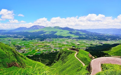
Introducing Aso in Kumamoto Prefecture! This video, titled “Best Views of Japan – Unexplored|Searching for Laputa in Aso, Only To Find That Aso Is Laputa!” (日本一の絶景 秘境 ラピュタの道を阿蘇に探しに行ったら、阿蘇の全てがラピュタだった), was released by “Drone RangerMiura.” It introduces the beautiful summer scenery of Aso, Kumamoto Prefecture, in Japan’s Kyushu region. The scenery of Aso Gogaku (阿蘇五岳, The Five Peaks of Mt. Aso), shot via drone, looks just like the world of the Studio Ghibli movie "Laputa: Castle in the Sky." In the Aso area, there are sightseeing spots called "Laputa Road" (ラピュタの道) and "Laputa Modoki" (ラピュタもどき), which have been attracting attention from people who enjoy going on casual drives to enjoy scenic locations. A Look at Laputa Road, Shown in the Video Photo:Aso, Kumamoto Prefecture The official name of “Laputa Road” is “Aso City Road Kario Main Line” (阿蘇市道狩尾幹線). From Prefectural Road 149 to Prefectural Road 339 (a.k.a. Milk Road), which runs over the outer rim of the mountain, a mysterious phenomenon creates a sea of clouds, allowing for breathtaking views. At 0:33 in the video, cows and horses are shown, and at 1:05, a beautiful waterfall can be seen. In the Aso area, you can go for a walk and discover the unexplored natural scenery, as well as enjoy activities, such as horseback riding and stargazing. Popular Spots in the Aso Area Introduced in the Video Photo:Daikanbo Lookout on Mt. Aso, Kumamoto Prefecture There are many spots in the Aso area where you can enjoy superb scenery, such as the Laputa Road Observatory and the Daikanbo Lookout (大観峰展望台) on Daikanbo, one of the peaks of the Northern Outer Rim of Mt. Aso. If you visit the Aso area to view the scenery, be sure to stop by the observatory! There are also many park facilities, such as the Oku-Aso Fruit Garden (奥あそフルーツガーデン), Rakunoh Mother's Aso Milk Ranch (阿蘇ミルク牧場), and Aso Farmland (阿蘇ファームランド). Be sure to check out Aso Shrine (阿蘇神社) as well! Points To Note When Sightseeing in the Aso Area Photo:The Nanatsugama Caves, Kumamoto Prefecture In the Aso area, there are many places of interest, such as the Nanatsugama Caves in Saga Prefecture's Karatsu, which is designated as a national natural monument, and Kusasenrigahama. However, due to risk of eruption, the area around the crater has been placed on alert and entry is now restricted. The 2016 Kumamoto earthquakes also caused some road closures in the Aso area. When visiting Aso, be sure to pay attention to observation information and alerts/warnings. Summary of the Aso Area Photo:Mt. Aso, Kumamoto Prefecture Aso is one of the most popular tourist spots in the Kyushu area thanks to the natural beauty of the mountains and sea. If you're looking to experience what it's like to be in the world of "Castle in the Sky," then you should definitely drop by Aso for a visit! 【Tripadvisor】Mt. Aso https://www.tripadvisor.com/ShowUserReviews-g298212-d320703-r710938456-Mt_Aso-Kumamoto_Prefecture_Kyushu.html -
 Video article 3:25
Nara Prefecture's Beautiful Ryuogabuchi Pond Is a Great Place for Taking Instagram Photos! Check Out the Video To See Its Beauty for Yourself!
Nature Travel- 221 plays
- YouTube
Ryuogabuchi Pond – A Photographer's Dream Do you know of the mysterious pond deep in the mountains of Nara Prefecture? This time, we'll introduce the video "【日本の絶景】新緑の龍王ヶ淵 Ryuogabuchi Superb view of Nara Japan 4K," uploaded by "SOTOBURA." Ryuogabuchi Pond is a famous location for photography in Uda City, Nara Prefecture, thanks to its beautiful reflective water surface. The crystal-clear pond is also a popular spot for photographers as the surrounding mountains reflect off the water's surface like a mirror. It's also famous as an "instagrammable" location in Japan. And with that, let's dive into the video of Ryuogabuchi Pond! A Closer Look at Ryuogabuchi! Photo:Ryuogabuchi Pond, Nara Prefecture Ryuogabuchi is located on the hillside of Mt. Nukai, a small mountain in Yamato Fuji, and the water flowing from the approximately 530m tall mountain is crystal clear, creating a mysterious pond. At 1:08 in the video, you can see the mysterious reflection of the trees of Mt. Nukai on the surface of the pond. The pond is 150 meters across from east to west and 100 meters across from north to south, making it a popular walking course. Some parts of the trail can be marshy and sometimes wet, so be sure to wear some comfortable sneakers. The nearby Horikoshi Shrine worships Toyotama-hime, who appears in the folk tale Urashima Taro. The video shows the quiet surface of the pond, but there are a lot of tourists on holidays, so we recommend visiting on a weekday to avoid the crowds and enjoy a quiet view of the pond. The Best Time to Visit Ryuogabuchi Pond Photo:Starry skies at Ryuogabuchi Pond, Nara Prefecture Ryuogabuchi is an amazing place to visit in the summer when the leaves are fresh and green, and in the fall when the leaves change to beautiful shades of red and orange. You can also enjoy breathtaking snowy scenery during the winter months. That being said, if you're driving in winter, you'll need to be prepared with snow tires. On a clear, windless day, the lake does not stir, and the surrounding scenery is said to reflect beautifully off of its surface. Because it is located deep in the mountains, you'll be able to see the stars on clear nights as well. Fishing is prohibited at Ryuogabuchi Pond, as it's considered a place of faith. Sightseeing Around Ryuogabuchi Pond Photo:Murouji Temple, Nara Prefecture There are many tourist attractions, including temples, around Ryuogabuchi in Nara Prefecture. In particular, nearby you'll find Murouji Temple and Onoji Temple, for which the nearest station, Muroguchi-Ono Station, is named. Approximately 100 mikumari cherry trees line the banks of the Hono River and they're lit up, making it a popular cherry blossom spot in the city. Ryuogabuchi is only 10 minutes away from the Hari Interchange on the Meihan National Highway (名阪国道針IC), so it's a good place to visit by car. Parking is also available, so you can visit easily. Summary of the Ryuogabuchi Area Photo:Ryuogabuchi Pond, Nara Prefecture Check out the video of Ryuogabuchi and be soothed by the clear blue skies and tranquil pond. If you're looking to relax and get away from work, be sure to visit Ryuogabuchi. You can also enjoy listening to the playful sounds of fish and frogs jumping in the pond. Just walking around the promenade while taking in the natural scenery is sure to make you feel at peace. 【Tripadvisor】Ryuogabuchi https://www.tripadvisor.com/Attraction_Review-g1022867-d19690682-Reviews-Ryuogabuchi_Pond-Uda_Nara_Prefecture_Kinki.html -
Video article 3:12
Mt. Daisen and Kitanizawa Stream - Two Places Used to Make Commercials With Famous Artists! Be Amazed by the Natural Scenery of Tottori Prefecture in This 4K Video!
Nature- 277 plays
- YouTube
Mt. Daisen and Kitanizawa Stream in Tottori Prefecture This video, titled "[4K UHD] Summer Mt. Daisen and Kitanizawa stream" ([ 4K UHD ]夏の伯耆大山と木谷沢渓流 Mt.Daisen & Kitanisawa Stream in Summer), was created by AQUA Geo Graphic. It's an introductory video showing Mt. Daisen and Kitanizawa Stream. Mt. Daisen is a mountain at 1,729m (5,700 ft.) above sea level in Tottori prefecture, in Japan's Chugoku region. It is a stratovolcano, but it is not active at present. It is also known as the sacred peak that represents the Chugoku region of Japan. Mt. Daisen is sometimes called Pansan or Hoki Daisen. The name Hoki Daisen derives from the history of western Tottori Prefecture, which was once called Hoki Country. Mt. Daisen is a popular scenic location that has been selected as one of Japan's "Top 100 Mountains" and Japan's "Top 100 Views." The Kitanizawa Stream is a clear stream that originates from Mt. Daisen, and is also designated as a walking route for sightseeing on Mt. Daisen. It is filled with many tourists, especially during the fall foliage season. The video introduces the fresh greenery of Mt. Daisen and the Kitanizawa Stream in beautiful 4K footage. You can enjoy the beautiful natural scenery, the chirping of birds, and the natural sounds of the flowing river, making it seem as if a mountain stream is actually flowing right in front of you. Mt. Daisen and Kitanizawa Stream- Two Beautiful Instagram Locations Photo:Kitanizawa mountain stream When visiting Mt. Daisen, we recommend taking a guided tour with the Oku-Daisen tour guide. It's a popular walking tour where you can enjoy the seasonal natural scenery, such as bird watching in the summer, autumn leaves in the fall, and snowshoeing in the winter. Keep in mind that the tours require a minimum of people before starting. Reservations can be made with the Kofu Tourism Association by phone or email. The first Saturday of the month is Kitanizawa Tour Day, which includes a photo and allows pets and elementary school students to accompany the tour. Feel free to sign up for this walking route, as it's a great way to capture some Instagram-worthy pictures. The crater at the top of Daisen is marked by the rim of a volcano, indicating that it was once a volcano. It's also locally called Hoki Fuji. If you fancy yourself a hike, why not try climbing to the famous Hoki Fuji Rim to see the natural landscape of Mt. Daisen? Speaking of Mt. Daisen, in winter, we recommend the Oku-Daisen Ski Resort. It's the largest ski resort in Tottori Prefecture, with 400 free parking spots. Reservations should be made early, as the resort is quite popular. Oku-Daisen Was Used for Suntory's Natural Water TV Commercials! Photo:Houki Fuji among the stars In 2017, a commercial for Suntory Natural Water, featuring world-renowned female artist Utada Hikaru, was set in Oku-Daisen, a famous mountain that is said to be the highest peak in the Chugoku region. Oku-Daisen is a place where the air and water are so clean that it is said to be a mountain of water, and the atmosphere of its mysterious forest is something straight out of an anime or some other mythological world! The numerous climbing spots capture the hearts of visitors. Okudaisen (奥大山) has a vast beech forest, where you can enjoy a panoramic view of the majestic mountains, and you can see the beautiful starry sky that Utada Hikaru sang about in the TV commercial "#Hoshi Suge" (These stars are beautiful!). The mountain stream that Utada Hikaru visited in the TV commercial is featured throughout this video, where you can enjoy the clear river water of the naturally flowing stream. If you watch the video, you might be able to feel what Utada Hikaru felt, surrounding by the natural beauty of Okudai Mountain. Mountain Climbing and Sightseeing at Mt. Daisen and Kitanizawa Stream Kofu City (江府町, Kofu cho), in Tottori Prefecture, is home to Oku-Daisen, mentioned earlier in the article. The air here is incredibly clear, making it a great place for stargazing, and many campers and photographers come here every year. In the surrounding downtown area and hotels, you can enjoy incredible gourmet cuisine, such as seafood from the Sea of Japan. Summary of Mt. Daisen and Kitanizawa Stream Hoki Daisen Station (JR West) in Yonago is a convenient way to get around, especially for trips to Mt. Daisen, home to the Kinayazawa Stream, one of the clearest rivers in Japan. We recommend using a local bus for transportation from Hoki Daisen Station to hotels, accommodations, and tourist destinations around Mt. Daisen. The highlight of this video is the Kitanizawa Stream, which is shown from 0:36 to the end of the video. The clear water flowing through the lush greenery of a mountain stream in summer, the beautiful moss on the rocks of the stream, and the beautiful sound of the river. It's a truly amazing atmosphere. The video is pleasing to both the eyes and ears. Please enjoy the beauty of Mt. Daisen and the Kitanizawa mountain stream. -
Video article 2:15
Hiking at Yoshino Kumano National Park at Higashi-Odaigahara! There Are Many Highlights, Including Beautiful Scenery Woven by Nature and Powerful Cliffs!
Nature- 48 plays
- YouTube
奈良県・吉野熊野国立公園「東大台ヶ原」紹介動画の見どころ この動画は「atsushi matsumoto」が公開した奈良県・吉野熊野国立公園「東大台ヶ原」を紹介した公式プロモーション動画「奈良県・吉野熊野国立公園「東大台ケ原」公式プロモーション(春夏編)」であり、東大台ヶ原における綺麗な自然の変化を高画質で楽しむことが出来る。 「東大寺」や「奈良公園」など日本屈指の観光地である奈良県。 ここには日本の国立公園に指定されている「吉野熊野国立公園」が存在する。 この記事では吉野熊野国立公園の中でも「東大台ヶ原(ひがしおおだいがはら)」エリアのハイキングコースやおすすめの楽しみ方などを紹介する。 奈良県・吉野熊野国立公園「東大台ヶ原」とは? 吉野熊野国立公園は、1936年に日本の国立公園に指定された自然豊かな公園であり、総面積61,406haという広大な地域は、奈良県・三重県・和歌山県にまたがっている。 また公園のほとんどは奈良県に属しており、大きく分けて山岳部・河谷部・海岸部に分類される。 吉野熊野国立公園の山岳部に属している「大台ヶ原山」は、奈良県と三重県の県境にある山で、「日本百名山」「日本百景」「日本の秘境100選」に選ばれるほど、日本でも有数の景勝地として観光客が訪れる。 大台ヶ原山に建設されている「大台ヶ原ビジターセンター」では大台ヶ原山の歴史や文化を学ぶことができる観光施設だ。 また、ビジターセンターより東側の「東大台ヶ原」では一般開放されたハイキングコースがあり、日本の四季を楽しむ事ができるため、観光客に人気だ。 充実したハイキングコースは初心者でも楽しめる! 東大台ヶ原では日本の四季を楽しむ事ができるハイキングコースが観光客に人気である。 ハイキングコースのスタート地点となる大台ヶ原ビジターセンターには駐車場があるため、気軽に観光で来ることが出来る。 ハイキング初心者の方にもおすすめだ。 東大台ヶ原のハイキングコースには様々な見どころが存在し、コースのほとんどは遊歩道により整備されている。 「苔探勝路(こけさがしかつみち)」ルートは、かつて苔が生い茂るほどの自然だったが、現在は苔を再生させるため生物の侵入を妨げる柵が設けられている。今は、ササを多く見ることが出来る。 「中道」ルートは、自然の変化と鳥たちのさえずりを感じることができる場所だ。 東回りのルートにある展望台「日出ヶ岳」は、大台ヶ原山の山頂であり、遠くに富士山が見えることもある。また、倒木が広がる「正木峠」やシロヤシオの自生地である「シロヤシオのトンネル」も見どころだ。 西回りのルートでは、「シオカラ谷」の吊橋を越えると「シャクナゲ群落」があり、5月から6月にかけて綺麗なシャクナゲがトンネルを作る。 また、約800メートルの断崖絶壁の絶景を楽しめる「大蛇嵓(だいじゃぐら)」は、インスタ映えするスポットだ。 日本の四季を楽しみたいという方におすすめの季節は、シャクナゲの咲く5月から6月ごろや紅葉の季節である11月ごろだ。 姿を変えた東大台ヶ原を見ることが出来るだろう。 奈良県・吉野熊野国立公園「東大台ヶ原」紹介動画まとめ 奈良県・吉野熊野国立公園「東大台ヶ原」の魅力を紹介した。 東大台ヶ原は、自然を肌身で感じることができるハイキングにおすすめの観光地だ。 動画をご覧になって東大台ヶ原が気になった方は、ぜひ観光に行ってみてはいかがだろうか。 東大台ヶ原のハイキングコースへのアクセスは、車で大台ヶ原山の麓から国道169号線を抜け、大台ヶ原ドライブウェイを通ることで到着できる。 この道は自然環境の変化によりたびたび通行止めになるため、東大台ヶ原を観光に訪れる際は、事前に気候を調べて行くと良いだろう。 -
Video article 6:56
A video full of highlights of the beautiful cherry blossoms in full bloom at Shinjuku Gyoen National Garden! A spot to enjoy nature in Shinjuku, Tokyo, a metropolis lined with skyscrapers
Nature- 62 plays
- YouTube
新宿御苑の桜をご紹介 「日本の都会のなかで桜を楽しみたい」 高層ビルが立ち並ぶ都会のなかにある自然は、なんとも言えない魅力がありますよね。 都会のなかの桜もきれいなピンク色と高層ビルのコントラストがとても美しいです。 そのような都会のなかで桜を楽しみたい人に今回は、日本の有名な観光地である新宿御苑の桜を紹介したいと思います。 この記事では、日本の観光地である新宿御苑の桜の特徴や魅力を解説しています。 新宿御苑の桜を撮った、美しい4K動画も紹介しているので、気になる方はご覧ください! 日本の観光地である新宿御苑の桜の特徴 日本の観光地である新宿御苑の桜の特徴は、広大な敷地のなかでさまざまな品種の桜が楽しめることです。 有名なソメイヨシノは3月下旬ごろから開花し、4月上旬まで咲いています。 薄ピンク色のソメイヨシノの花びらはとてもきれいで、満開になると絶景を楽しめます。 新宿御苑の桜は他にも、河津桜や陽光、大島桜や枝垂れ桜など、白色の桜や濃いピンク色の桜を鑑賞することができる桜好きにはおすすめのスポット。 桜が見頃のシーズンには国内外から観光客がきてお花見するので少し混雑しますが、とても美しい景観を楽しめる名所なのでぜひ見てください。 日本の観光地である新宿御苑の桜の魅力とは 日本の観光地である新宿御苑の桜の魅力は、きれいな桜と高層ビルのコントラストを、広大な敷地のなかで思う存分楽しむことができるところ。 新宿御苑は日本庭園やひろい芝生など、ゆったり桜を鑑賞できるポイントがたくさんあります。 新宿御苑のなかの大きな芝生の広場では、シートをひいて桜を鑑賞したり、お弁当を食べたり、友達とお話したりと、ゆったり楽しんでいます。 新宿御苑はお酒がNGなので、大騒ぎしている人が少なく、ゆったり桜を鑑賞できるところもいいところ。 2019年からは桜のライトアップのイベントも行っているので気になる方は要チェック。 ライトで照らされた桜は幻想的できっと一生に残る思い出になるはずです。 新宿御苑のなかには、さまざまな桜を楽しめるスポットがあるので、桜好きの方はぜひ行ってみてください! 日本の観光地である新宿御苑の桜をうつした動画はこちら 「Discover Nippon」が制作する新宿御苑の桜を紹介している動画がおすすめです。 こちらの動画は日本の観光地である新宿御苑の桜を美しい4K動画で見ることができます。 この記事を読んで気になった方は、見てみましょう! 日本の美しい桜を都会のなかで楽しめる春の新宿御苑。 日本の他の場所では見ることができない景色をご覧になれる、おすすめのスポットです。 桜がすきな方はぜひ春の新宿御苑を観光してみてください! -
Video article 9:03
Hanamomo no Sato in Nagano Prefecture's Shimoina District Is a Spectacular Location Dyed in Shades of Pink! Feel the Arrival of Spring at This Paradise on Earth in Japan!
Nature- 218 plays
- YouTube
Highlights of Hanamomo no Sato in Nagano Prefecture This video, titled "JG☆☆☆4K 長野 花桃の里 Nagano,Peach Flowers at Hanamomo no Sato," was released by "JAPAN GEOGRAPHIC." It showcases Hanamomo no Sato, an attractive place for sightseeing due to its beautiful peach and cherry blossoms. In this article, we'll introduce Hanamomo no Sato in Nagano Prefecture! What are the best times to see and highlights of Hanamomo no Sato in Nagano Prefecture, which can be enjoyed from the train window? Hanamomo no Sato has a drive course that you can enjoy through the window of a cart and is called "Hanamomo Kaido" (はなもも街道, lit. "Peach Blossom Highway").The best time to see Hanamomo no Sato, which is said to be Japan's best Momogen-go, is usually from mid-April to late April.The scenery woven with gradations of red, white, and pink flowers over about 40 kilometers is worth seeing. A "Flower Peach Festival" will also be held to coincide with the flowering.Please check the details of the blooming conditions and the flower peach festival as they are updated from time to time on the official website of Nisshin Onsen. Enjoy Hot Springs and the Charm of Hanamomo no Sato in Nagano Prefecture! On Hanamomo Kaido, there are two places to stay, Gessen and Hirugami Hot Springs, where you can take your time admiring the beautiful cherry blossoms in the surrounding area. There are hot spring accommodations where you can take a day bath in the hot spring village, which is also the venue of the "Hanamomo Festival" (花桃まつり, Peach Blossom Festival), so why don't you stop by after enjoying the flowers? In addition to Gohei-mochi, seasonal curry bun, wheat bun, thick shiitake mushrooms, and so on can be purchased at the roadside station "Hanamomo-no-sato" as well as lunch such as wild vegetable soba. There are also a variety of souvenirs you can purchase, such as goheimochi (rice cakes), so be sure to give them a try as well. Summary of Hanamomo no Sato in Nagano Prefecture In this article we introduced Hanamomo no Sato, one of the best places in Japan for viewing peach and cherry blossoms! Achi Village, known more commonly as "Hanamomo no Sato" (花桃の里, Peach Blossom Village) has one of the best nighttime views in Japan. There are also night tours available at Hanamomo no Sato, so be sure to take in the sights at night! -
Video article 2:24
The Encounter of Waves, Brought Together by Two Islands, Is Reminiscent of Long Lost Lovers Being Reunited. Come Check Out the Amazing Scenery at Lover’s Cape in Wakayama Prefecture!
Nature Travel- 281 plays
- YouTube
The Gorgeous "Lover’s Cape" in Wakayama Prefecture! This video, titled "Lover's Cape - Wakayama - 恋人岬," introduces Lover’s Cape, a famous tourist spot in Susami, Wakayama prefecture in Japan's Kansai region. Lover's cape is also included in the "8 Scenic Views of Susami." The fierce waves split after hitting Kuroshima, and the shape and action of the 2 waves hitting each other again is said to be similar to putting one’s hands together in pray, thus, the waves are called "Gassho Nami" (合掌, Gassho, "Putting one's hands together in prayer, 波, Nami "Wave"). You can see the waves coming together at 0:48 in the video. The mysterious waves are called "Meotonami" (夫婦波, Wedded Waves) and the towering rocks are called "Meoto Iwa" (夫婦岩, Wedded Rocks) and has been selected as one of the "66 Waterfront Areas to Be Cherished in Wakayama" for its beautiful view. Because of its romantic name and scenery, it is popular with couples, and as the name "Lover's Cape" implies, many couples visit here. Lover’s Cape, a Popular Tourist Spot in Wakayama Prefecture Source :YouTube screenshot Lover’s Cape, introduced in the video, has 2 main attractions. The first is a cave called "Gama," located on the west side of Kuroshima. Here, you can enjoy scuba diving from March to the end of April and from late June to the end of October. Historically, there is a legend that it contains hidden treasures of the Kumano navy, and many people visit during scuba diving season. The second attraction at Lover's Cape is that between October and January and between April and September, the slopes of Lover's Cape are covered with bougainvillea flowers. You can also enjoy fishing here as well. Lover’s Cape is A 15-minute walk from Mirozu Station or a 15-minute drive from the Susami Interchange on the Kisei Expressway. Free parking is also available, so be sure to take advantage of it if you're going by car. The Waves of Lover's Cape Photo:Wakayama prefecture・Meotonami Lover's Cape consists of two islands one with a large reef and the other with a small reef. The islands are called Oki-no-Kuroshima and Riku-no-Kuroshima respectively. The Karekinada coastline, which was formed by upheaval and erosion of the Kii Peninsula, is famous for the phenomenon known as "Tombolo," where a road is formed between the two islands, and you can enjoy the dynamic ocean with waves on both sides. The entire island of Esuzaki Island in Wakayama Prefecture, where Lover's Cape is located, is a sacred area, and Kuroshima Benzaiten (a Buddhist goddess) is located at the bottom of the cliff at Lover's Cape. The bright red torii gate can be seen at 1:48 in the video as well. The view from Lover’s Cape in Wakayama prefecture Photo:Susami・Sunset from Roadside Station Susami The sunset that can be seen from Lover’s Cape is so gorgeous that it was chosen as one of the Top 100 Sunrise / Sunset Views of Wakayama Prefecture, and many tourists travel to see it. Being that "Meotonami" was selected as one of the "8 Scenic Views of Susami," it's a great place to quietly spend time gazing at the sunset and waves. There is also a restaurant at Lover's Cape called Italian Café BUSH. The interior of the restaurant is modeled in a Mediterranean style and you can enjoy pastas or pizza made with local ingredients. Their business hours are 9:00-18:00 so you can appreciate Wakayama prefecture’s sunset while enjoying a delicious meal at the restaurant. Lover’s Capes Around the World Photo:Izu・Lover's Cape Bell In addition to Lover's Cape in Wakayama Prefecture, there are many other Lover's Capes around the world. At Lover's Cape in Izu City, Shizuoka Prefecture, there's a story about a man who rang a bell when he passed through the cape, and it is said that if you call out the name of your beloved while ringing the bell, your love will be fulfilled. Lover's Cape in Guam is a spot where you can enjoy a spectacular panoramic view of Tumon Bay, which is depicted on the national flag of Guam. It's called "Lover's Cape" because of a story about a couple who pledged their eternal love to each other and jumped into the sea. The Lover’s Cape in Kashiwazaki in Niigata prefecture, is located at the Nihonkai Fisherman’s Cape, and it is a place where you can ring a bell with a heart-shaped plate for good romantic fortune. Summary of Lover’s Cape Source :YouTube screenshot What did you think about Lover's Cape? Lover’s Peak is definitely a place to go to when sightseeing in Wakayama. It has incredible views of nature romantic sunsets as well. Be sure to bring your lover with you when you visit! 【Official Website】Lover’s Cape – Izu City Tourist Information dedicated website http://kanko.city.izu.shizuoka.jp/form1.html?pid=2528 【Trip Advisor】Lover’s Cape https://www.tripadvisor.com/Attraction_Review-g1121354-d8538044-Reviews-Lover_s_Cape-Susami_cho_Nishimuro_gun_Wakayama_Prefecture_Kinki.html -
Video article 3:18
Fujido Cave – This Mysterious 2.2 km Long Limestone Cave in Gunma Prefecture, the Largest in the Kanto Region, Will Take Your Breath Away! The Stalactites, Which Take 100 Years to Grow 1 Centimeter, Are a Famous Power Spot!
Nature- 164 plays
- YouTube
An Exciting Trip to the Largest Limestone Cave in Japan - Fujido Cave! This video, titled "The Largest Limestone Cave in Kanto!" (関東最大級の鍾乳洞 『不二洞』), shows a fabulous view of the Limestone cave located in Gunma. There are many mysterious limestone caves found throughout Japan. Of all the limestone caves, Fujido Cave, located in Kawawa Nature Park in Ueno-village, Tano District is the largest in the Kanto region, with an astonishing length of 2.2 km. Fujido is designated as a natural monument of Gunma Prefecture. If you explore inside of the Fujido, you're sure to have an extraordinary experience! You can see a number of breathtaking views in the video. Be sure to check it out to see the mysterious Fujido Cave! Fujido Cave Photo:Fujido Cave A limestone cave is a natural cave that is formed over a long period of time by the gradual erosion of limestone rock due to the inflow of underground water. It's said that the Ueno-village area, where Fujido Cave is located, was once covered with a deep virgin forest. Villagers in the area discovered the cave about 1,200 years ago, and since then, the cave has been used as a place for Buddhist training. In the Fujido Cave, the Fujido Yayoi Matsuri (festival) is held every March. Through the festival, people pray for the safety of the Fuji cave, the largest cave in the Kanto region. Highlights of Fujido Cave! Source :YouTube screenshot You can see the exploration of Fujido Cave at 0:38 in the video. At the end of a 120-meter underground tunnel, visitors climb up a 40-meter pit staircase to find a spacious limestone cave. The cave is kept cool throughout the year at a temperature of about 11 degrees Celsius(51.8°F). In the limestone cave, there are a lot of Instagram worthy spots made by nature such as the "Five Colored Clouds" (0:54), "Yama's Staff of Pilgrimage" (1:25), "Dragon King Falls" (1:44), and "Nyoraido" (2:02) and many more. There’s a legend about "Yama’s Staff of Pilgrimage" that says if you make a wish and touch it seven times, your wish will come true. Source :YouTube screenshot Inside of the cave, there are 45 spots named after Buddhist beliefs. At 2:17 in the video, you'll see a sparkling tower made of limestone. This tower, called "Renge-no-To" (Lotus Tower) is the largest stone in the cave. Next, at 2:34 you can see "Hi-no-Hashira" (The Pillar of Flame), and at 2:49 the sacred spot known as "Gohyaku-Rakan." It is said that it takes about 100 years for the limestone to grow 1 cm. Next time you visit Fujido, pay attention to the artistic shape of the cave and try to comprehend the amount of time it took to form. Summary of Fujido Cave, the Largest Cave in the Kanto Region Photo:Fujido Cave A limestone cave is a mysterious phenomenon created by nature. In recent years, the area around the Fujido Cave has become a popular power spot. Inside the cave you can also see the lit-up limestone, as shown in the video. Since the footing in the cave is not very good, we recommend that you wear comfortable clothes and shoes that are easy to get around in. If you're looking to travel to some of Japan's best-kept secrets, come to the mysterious Fujido Cave and experience the beauty of mother nature. Check out the video and feel for yourself the deep history and wonder concealed within the Fujido's limestone walls! ◆Fujido Cave◆ 【Address】665 Kawawa, Ueno-village, Tano Gun, Gunma Prefecture 【Access】35 minutes by car from Shimonita Interchange on the Joshinetsu Expressway 【Hours】9:00 AM - 4:30 PM ※ 9:00 AM 〜 4:00 PM in November, 10:00 AM〜 3:00 PM from December to mid March 【Closures】Open year round 【Average time spent here】About 40 minutes 【Parking】Available 【Telephone】 0274-59-3117 【Entrance fee】Adults 800 yen/Elementary and middle school students 500 yen (※ as of November 2019) -
Video article 11:19
Enjoy a Cup of Pure Bliss in the Great Outdoors! Enjoy an Out-of-the-Ordinary Experience With Coffee Brewed From the Spring Water of Oike Spring in Oita Prefecture
Nature- 29 plays
- YouTube
This video, titled "[Hiking] Coffee From a Spring - A Walk in the Woods and a Quiet Time" (【ハイキング】湧き水でコーヒー - 森林散策と静かな時間), was released by "Morinone Channel" (モリノネチャンネル). Wouldn't it be wonderful to make coffee from a clean spring in the mountains and take in the magnificent scenery? The Oike Spring Group in Yufu City, Oita Prefecture, introduced in the video, is an area at the source of the Aso River. The rainfall on Mt. Kurodake is filtered underground over a long period of time to produce clean spring water. It's very comfortable and cool even in summer as it is located 850 meters above sea level. Sitting under a tree, boiling water from the spring with a portable stove, and drinking coffee will refresh your body and mind. -
Video article 5:38
Savor the Beauty of Nature at "Japan Alps Kamikochi" in Japan's Scenic Shinshu Region! Enjoy a Relaxing Time Surrounded by Greenery and Negative Ions!
Nature- 62 plays
- YouTube
Sightseeing in the Japanese Alps in Kamikochi This video, titled "LEAP | Kamikochi (上高地) - Japan - UHD 4K," was released by Jonathan Teo. It shows an aerial view of Kamikochi, a tourist resort area overflowing with natural beauty in Nagano Prefecture. Kamikochi, located in Matsumoto City in western Shinshu, is a scenic, mountainous area situated at an elevation of approximately 1,500 meters above sea level. The entire area makes up Chubu Sangaku National Park (中部山岳国立公園), and is a base for climbing the Hotaka Mountain Range (穂高連峰) and Mt. Yari (槍ヶ岳). If you want to enjoy the beautiful scenery, plan a trip to Kamikochi and explore the mountain route! Recommended Sightseeing Spots in Kamikochi Photo:Kamikochi, Nagano Prefecture After the opening of the mountain, many tourists flock to Kamikochi, which has a series of peaks that are coveted by alpinists, for the purpose of mountain climbing. When climbing in Kamikochi, be sure to get your fill of the unique mountain scenery. Kappa Bridge (河童橋), the symbol of Kamikochi, is a popular spot where you can enjoy a great view. Be sure to also check out Taisho Pond, Myojin Pond, and Tashiro Pond, which are known for their natural beauty. At 0:53 in the video, you can see the Azusa River glowing a cobalt blue. Key Points to Remember When Visiting Kamikochi Photo:Kamikochi, Nagano Prefecture Kamikochi is a fun mountain for both beginners and advanced climbers. If you're looking for a casual hike, consider planning a day trip. The climate in the mountains can change easily, so be sure to suitable clothing when climbing in the Kamikochi area. Also, be sure to bring maps, drinks, and emergency food in your luggage just in case. Inns and Souvenir Shops at Kamikochi in Shinshu, Nagano Photo:A hot spring at an inn There are a number of hot spring inns and tourist hotels in the area around Kamikochi. After a day of hiking, we recommend staying at an accommodation with a hot spring to relax and rejuvenate. There are also many tourist attractions nearby, including restaurants serving local gourmet food and souvenir shops. Summary of Kamikochi, Located in Shinshu, Nagano Photo:The scenery of Kamikochi, Nagano Prefecture There are many scenic spots like the ones shown in this article's video, in Kamikochi. Walking around while enjoying the unique mountain scenery is sure to leave you feeling refreshed. To protect the environment around Kamikochi, personal vehicles are prohibited in and around the area. Park your car at the parking lot in Sawatari before Kamikochi and use the shuttle bus to get there. 【Official Website】Kamikochi Official Website|Area Introduction https://www.kamikochi.or.jp/learn/spots 【Tripadvisor】Kamikochi https://www.tripadvisor.com/Tourism-g12830931-Kamikochi_Matsumoto_Nagano_Prefecture_Koshinetsu_Chubu-Vacations.html -
Video article 2:34
A UFO Landing Spot?! Take a Look at the Beautiful Scenery of the Power Spot "Kizuro"! Enjoy the Surprising, Mysterious Sight of This Unexplored Region Known Only by a Select Few!
Nature- 616 plays
- YouTube
A Mysterious Power Spot in a Valley Surrounded by Mountains? More About the Unexplored Area of Kizuro, Japan This video "Unexplored Japan (Kizuro) (日本の秘境 (木津呂))" was created by "hashieemov". Kizuro is an unexplored region in Japan in the town called Kiwa (紀和町, kiwachou). Kiwa is located in Kumano city, Mie prefecture in the Tokai region of Japan. It is one of the most uniquely structured settlements to be found in Japan and attracts many tourists as it is thought to be a power spot. It has also been featured in the Japanese TV show "Nani kore, Chinkyakkei" (What's this? 100 Famous, Bizarre Views) and looks identical to a location from the movie "Your name" (君の名は, kiminonawa). In this video, we introduce to you the Kizuro Village through aerial drone photography. Kizuro: An Unexplored Region of Japan. Why Is It Shaped So Strangely? Source :YouTube screenshot Kizuro Village is located in a basin surrounded by mountains in a town called Kiwa in Kumano city, Mie prefecture. It is situated in the center of a white, oval area of land with a river running through it. The unusual and unique shape of the terrain is one of the characteristics of this small, ancient settlement. You can take a look at the terrain from 0:07 in the video. Depending on which direction you look at it from, the terrain appears circular and the highest point from which you can see it is the top of Mt. Shimzau (嶋津山, shimazuyama) in Kumanogawa, Shingu in Wakayama prefecture. The mountain path is very steep and rugged so please take a map if you plan on climbing it. The mouth of the Kitayama river (北山川, kitayamagawa) which surrounds Kizuro Village is part of the Kumano pilgrimage which is registered as a World Heritage Site. The settelement of Kizuro is thought to have been formed approximately 1500 years ago after the eruption of a volcano caused the land to sink and was slowly eroded by the surrounding Kitagawa river, the shape of the settlement is still changing today. It has become a popular tourist spot because of its photographic terrain which looks similar to a UFO landing spot, with tour buses even operating in the area. There is an ancient practice in Asia called Feng Shui that can be used to forecast or predict fortune by reading the energy in an area. Feng Shui masters believe that the unique terrain surrounding Kizuro Village makes it a very important power spot. Being referred to as an "unexplored region" you would think that the area is very isolated, and therefore deserted, however in 2015 there were eleven people living in the area. The main industry is forestry, and lumber from the area (Kumano) is very valuable and is sold at a high price. Outdoor Activities in Kizuro, an Unexplored Region of Japan Photo:Camp In the opening of the video you can see a car, however there are very few car parks in the area and it could also be said that the access is rather inconvenient. However, a lot of outdoor activities can be enjoyed nearby such as camping, mountain climbing, an observation deck, rafting, Ikadanori and the flower grotto. It is a great spot to experience outdoor adventures! Kizuro Village Is Also a Popular Hot Spring Area Source :Official home page of the Yunokuchi Onsen The unexplored region of Kizuro is also popular as a hot spring area. Many people come to visit Yunokuchi Onsen which is surrounded by the Kumano mountains where the water is said to have healing benefits. Summary of Japan's Unexplored Kizuro Village Photo:Kizuro What do you think of Japan's Kizuro Village? If you decide to visit Kizuro Village, there are many other tourist spots you can enjoy in the area, such as the Maruyama-senmai Rice Field, Shishiiwa and Onigajou. You can access Kizuro from Kumano city center in approximately 60 minutes by car. -
Video article 2:28
Enjoy the Majestic Natural Scenery of Mt. Chokai and Tobishima Geopark in Akita Prefecture! Discover the Beauty of Shirataki Falls and the Mototaki Underflow!
Nature- 93 plays
- YouTube
Introducing Mt. Chokai and Tobishima Geopark in Nikaho City, Akita Prefecture This video, titled “[4K UHD ] Mt. Chokai/Tobishima Geopark: Fresh Greenery and Mototaki Falls (Shot on GH5 With Gimbal)” ([ 4K UHD ]鳥海山・飛島ジオパーク: 新緑の元滝伏流水 Moto-taki Waterfall ( shot on GH5 with Gimbal)), was released by “AQUA Geo Graphic.” Mt. Chokai & Tobishima Geopark is the name of Akita Fuji (秋田富士), Dewa Fuji (出羽富士), and Shonai Fuji (庄内富士), which have been selected as some of the 100 Famous Mountains and 100 Famous Geographical Features of Japan. Furthermore, it is also the name of the "Mysterious Island Tobishima" and "Chokai National Park," which is located about 30 km west of Mt. Chokai, and was recognized as a Japan Geopark in 2016. Nowadays it's called Mt. Chokai, but in ancient times it was known as "Torimiyama" and you could see a 360-degree view of the horizon from the top. Due to volcanic eruptions and other volcanic activities, this view is no longer visible and it is now called Mt. Chokai. The overall theme is "The cycle of water and life created by the Japan Sea and the plateau," and the sub-theme is "Nature and life created by warm currents, active volcanoes, and spring water." In this article, we'll introduce the "Mototaki Underflow," an ethereal waterfall flowing down a rock face at the foot of Mt. Chokai in the Mt. Chokai & Tobishima Geopark area. What Exactly is a “Geopark”? Photo:Mototaki Underflow, Akita Prefecture The word "geopark" (“ジオパーク” jiopaaku in Japanese) is a combination of the words “geo” and “park.” It was selected for the purpose of learning about the natural environment and ecosystems that spread across the land, as well as the culture and industries that people have created. At present, there are 43 areas selected as Japan Geoparks, and 9 of them are also recognized as UNESCO Global Geoparks. As they are sometimes called "大地の公園" (Daichi no Kouen, lit. "Earth Parks") in Japanese, they are famous for the various scenery they offer throughout the year, and are especially popular during the fall with the autumn leaves change to beautiful shades of red and yellow. There is also a sake brewery in the area that uses clean spring water, so if you like sake, be sure to take a tour of the brewery. The Mototaki Underflow Located at the Foot of Mt. Chokai Photo:Mototaki Underflow, Akita Prefecture The Mototaki Underflow is located at Mt. Chokai in Nikaho City, Akita Prefecture. Although it is called "Mototaki" (元滝, lit. "source waterfall"), the original source of the subterranean waterfall is currently closed to traffic, and the Mototaki Underflow is located about 200 meters downstream. As you can see from 0:42 in the video, the waterfall is relatively small, only 5 meters tall and about 30 meters wide, yet 50,000 tons of water flow from it each day. The fantastic scenery created by the moss and the subterranean stream flowing out of the gaps in the green rocks is fascinating, and surely allows for some beautiful photos to share on Instagram. Recommended Sightseeing Destinations Around the Mt. Chokai & Tobishima Geopark Area Photo:Scenery from Hokotate Observatory, Akita Prefecture 1. Mt. Chokai Omonoimi Shrine/Fukura Kuchinomiya (Chokaisan Omonoimi Jinja Fukura Kuchinomiya) An old shrine, said to be the oldest shrine in the Shonai region, with origins dating back to 1963. It sits on the summit of Mt. Chokai, and there are two satomiya (shrines built in a village for the convenience of worshippers) called "Kuchinomiya" (口ノ宮, lit. "entrance shrines") at the foot of the mountain, one at Fukuura and the other at Warabioka. 2. The Shirai Rice Fields and Weirs This farmland was developed in 1800 based on the concept of rice fields for the Han-School of Shonai Chido-kan by Yadayu Shirai, the county representative of the Shonai domain. There are many innovative ways to heat and utilize the cool spring water of Mt. Chokai, and you can see the fruits of the wisdom of the area's ancestors here. It's a 10-minute drive east from Yuza Station. 3. Hokotate Observatory Mt. Chokai & Tobishima Geopark is also famous for its mountain climbing, and the Hokotate Observatory is a popular tourist spot where you can enjoy the magnificent view of Mt. Chokai. The observatory is located at the fifth station of the mountain, which can be reached by car, so it's possible to stop by during your drive, and there are a number of mountain lodges on the way to the summit, so you can take breaks as you go. When climbing the mountain, we recommend asking for a mountain guide or participate in a geotour so that you can learn more about Mt. Chokai. 4. Chokai Blue Line Chokai Blue Line is a mountainous road that rises from zero to 1,100 meters above sea level, and during the fall, amongst the autumn foliage, it offers a spectacular view worthy of any bucket list. Summary of Mt. Chokai & Tobishima Geopark Photo:Mototaki Underflow, Akita Prefecture Mt. Chokai and Tobishima Geopark has become a nature-rich spot called "緑のダム" (The Green Dam) due to the planting of beech trees by the townspeople to preserve water quality and purify the water source. In addition to sightseeing, be sure to try some gourmet foods like delicious Akita Iwagaki Oysters, which contain many minerals from the spring water! 【Tripadvisor】Mt. Chokai https://www.tripadvisor.com/Attraction_Review-g298237-d1397297-Reviews-Mt_Chokai-Tohoku.html -
Video article 2:53
Is Fukui Prefecture's "Tojinbo" a Suspense-Drama Fan's Mecca? Steep Cliffs and Powerful Spiritual Energy at This Thrilling Sightseeing Location
Nature Travel- 135 plays
- YouTube
Fukui Prefecture's "Tojinbo" Tojinbo, in Fukui prefecture, located in Japan's Hokuriku region, is a series of vertical cliffs created by the rough waves of the Japan Sea. It is a rare type of sea cliff which can only been seen in 3 other places in the world. This video, titled "(4K) Aerial Drone Footage / Flown in Tojinbo in Sakai City, Fukui Prefecture" (【4K】福井県坂井市 東尋坊で飛ばしてみた / ドローン空撮), was produced by "Mattsu." The video shows the exposed rock face and jagged landscape of Tojinbo via aerial drone footage. The geological composition of the cliffs of Tojinbo is made up of pyroxene andesite and some of the cliffs tallest points are approximately 25m tall. Its strangely shaped pillars extend for 1km and it has been designated a Natural National Monument and Scenic Spot, and is also a part of the specially protected area of Echizen-Kaga Kaigan Quasi-National Park. It is also one of the world's 3 most geologically rare scenic spots, and therefore it is well known around the world. The origin of the name Tojinbo is said to have come from the name of a monk "Tojinbo" who lived long ago and was affiliated with Heisenji Temple and lost his life after being thrown off the cliff in a romantic tangle. After Tojinbo was thrown into the sea; another monk, his rival in love, was also pulled into the rough waves and tempestuous weather continued for 49 days. Or so the legend goes anyways... It is also famous for being used as a film location for climactic scenes in which the culprit tries to throw him or herself into the sea after making a confession in suspenseful TV dramas or movies. Tourist Attractions Around Tojinbo Photo:Tojinbo, Fukui Prefecture The Tojinbo cliffs, which is a rare rock formation even outside of Japan, is a famous place that even many Japanese would like to visit at least once. In order to preserve Tojinbo's amazing view there are no safety features such as fences installed there. You are able to walk around Tojinbo freely, however, please watch your step. The recommended tourist sites around Tojinbo are, Tojinbo Tower, Echizen Matsushima Aquarium, the caravan campsite Kyukamura Echizen Mikuni, Echizen Matsushima, Minato-machi Mikuni, Shibamasa World, and the Araiso Shoreline Esplanade. Also, if you take the Tojinbo/Oshima sightseeing boat tour, you will be able to see the cliff face from the ocean and will be able to enjoy all of the Instagrammable locations such as Lion Rock and Candle Rock. In addition, the Mikuni Fireworks Festival is held near Tojinbo in the summer and every year many tourists flock to see this event. Tojinbo's Famous Hot Springs and Gourmet Food! Photo:A crab dish When you the town Mikuni, in Sakai city, Fukui prefecture, that Tojinbo is in, try to stay at the Mikuni Kanko Hotel. Japan's Hokuriku region is famous for Echizen crab and the crab dishes made from Fukui's freshly caught crab are absolutely delectable! You should also definitely go to the nationally famous, Mikuni hot springs. Relax and rid yourself of stress by sightseeing in Tojinbo, eating delicious seafood and relaxing in the hot springs- All at the Mikuni Kanko Hotel. Summary of Tojinbo in Fukui Prefecture Source :YouTube screenshot One of the world's most beautiful sights! Directions (access by public transportation such as bus), parking, events and other information about Tojinbo in Fukui prefecture, can be seen on the Mikuni hot springs official website "Mikuni Marugoto Navi." Now that you've seen the beautifully taken drone footage, it’s time to see it in person! 【Official Website】The Official Website of the Mikuni Tourist Association | Tojinbo・Echizen crabs・Mikuni Hot Spring|A Website Full of Beautiful Sights to See and Fun Places to Visit http://www.mikuni.org/?lang=en 【Tripadvisor】Tojinbo https://www.tripadvisor.com/Attraction_Review-g1021160-d1385002-Reviews-Tojimbo_Cliff-Sakai_Fukui_Prefecture_Hokuriku_Chubu.html -
Video article 3:55
Daisekirinzan - A Place Where You Can Enjoy the Magnificent Nature of Okinawa, Unchanging Since Ancient Times! Leave Behind the Hustle and Bustle of the City on the Famous Trekking Courses!
Nature- 62 plays
- YouTube
Daisekirinzan in Kunigami District, Okinawa Prefecture This video, "Oishi Forest Mountain|A walk in the sky" (大石林山 空中散歩), was created by "Okinawaworld." Daisekirinzan is a mountain in Okinawa's Kunigami District, about a 3-minute drive from Cape Hedo (辺戸岬, hedo-misaki), the northernmost point of the main island of Okinawa. As seen from 0:15 in the video, the island has a karst landscape created by limestone from 250 million years ago. The many strange rock formations and beautiful scenery is reminiscent of Guilin in China, known for its depictions in ink paintings. Nearby is Ashimui (安須杜), which has been a sacred place since ancient times. From Cape Hedo, the mountains seem steep and forbidding, but once you actually enter the mountains, you'll find a peaceful paradise of subtropical flora and fauna. Most of Daisekirinzan is designated as a specially protected area of Yanbaru National Park. You can enjoy the magnificent nature of Yanbaru while making your way through the two main trekking courses. The History of Daisekirinzan Photo:Daisekirinzan, Okinawa Daisekirinzan is a "quasi-national park" in Okinawa, in accordance with the Natural Parks Act. The park is managed with the aim of protecting the beauty of nature and contributing to the health, recuperation, and knowledge of Japanese citizens. On September 15, 2016, along with the official designation of Yanbaru National Park, a part of the area previously designated as Okinawa Kaigan Quasi-National Park was transferred to Yanbaru National Park. Daisekirinzan is a must-visit sightseeing area in Okinawa, even winning the "Tripadvisor Excellence Award 2018" on TripAdvisor for the fifth consecutive year. The Two Main Trekking Courses of Daisekirinzan Photo:Banyan Tree in Oishi Forest Mountain, Okinawa ① Strange Rock / Churaumi Panorama Course As seen from 0:36 in the video, this is a course where you can experience the tropical karst landscape at the northernmost tip of Okinawa. It takes about 60 minutes to complete the 1,200m course. You can see the strange rocks and massive boulders from 0:45 in the video. In addition to strange rocks and boulders, there are also many places of worship, such as the "Stone Forest Wall," which is said to be full of spiritual power. There is also an observation deck where you can enjoy a panoramic view, and during good weather conditions, you can even see Yoron Island (与論島, yoron-to) and Okinoerabu Island (沖永良部島, okinoerabu-jima) in Kagoshima Prefecture (鹿児島県, kagoshima-ken). There is also a barrier-free course, which is 600 meters long and takes about 20 minutes to complete It's designed for the elderly and people in wheelchairs to enjoy. As seen from 2:00 in the video, there's also Eboshi-iwa Rock (鳥帽子岩) towering into the sky, as well as the mysterious Nabe-ike Pond (鍋池). ② Yanbaru Forest Course The Yanbaru Forest Course can be seen from 2:09 in the video. Even in the midst of Daisekirinzan, this is an area where the subtropical trees grow especially densely. It takes about 30 minutes to traverse the 1,000m-long course, and you can enjoy the magnificent natural scenery, including the huge banyan tree seen from 2:32 in the video. Summary of Daisekirinzan Photo:The Phantom Flower Mucuna Macrocarpa, Okinawa In addition to the two famous trekking courses, there are many other sightseeing spots in Daisekirinzan. The Okinawa Stone Culture Museum (沖縄石の文化博物館, okinawa-ishi no bunka hakubutsukan) is a geological and ethnic museum centered around Okinawan stones. Gajumaru Road (ガジュマルロード), also known as the "Path of the Wind" (風の道, kaze no michi) is a road winding along gorgeous scenery. If you're lucky, you might even get the chance to see the rare "Mucuna Macrocarpa," which grows naturally in the mountains of Yanbaru. Even Okinawans rarely come across this "phantom flower." In recent years, Daisekirinzan has been attracting attention as the largest spiritual area in Okinawa. Consider adding Daisekirinzan to your itinerary when you visit Okinawa! 【Official Homepage】Yanbaru National Park Daisekirinzan https://www.sekirinzan.com/en/ 【Tripadvisor】Daisekirinzan https://www.tripadvisor.com/Attraction_Review-g1025649-d1373544-Reviews-Daisekirinzan-Kunigami_son_Kunigami_gun_Okinawa_Prefecture.html -
Video article 1:51
Shirahama Beach - Discover the Beauty of Shimoda, Shizuoka at Izu's Largest Swimming Beach! The Bright Red Torii Gate Perched on the Cliffs Makes for Some Amazing Scenery!
Nature Travel- 286 plays
- YouTube
Shirahama Beach in Shizuoka Prefecture! The video this time is titled "Shirahama Beach - Shizuoka - 白浜 - 4K Ultra HD." It introduces the beautiful Izu-Shirahama Beach in Shimoda City, Shizuoka prefecture. When the weather is nice, Shirahama Beach glows a beautiful emerald green, making it very popular with surfers and tourists alike. The 700-meter-long white sand beach is one of the largest on Izu Peninsula. Enjoy making lasting memories at one of the most beautiful beaches in Japan! Don't forget to bring your camera either; There's plenty of great places to take pictures for your Instagram! Shirahama Beach, Shizuoka Photo:Shizuoka prefecture・Shirahama Beach Shirahama Beach, located in Shizuoka prefecture in Japan's Tokai region, is separated into 2 swimming areas: the Shirahama Central Beach section and the Shirahama Ohama Beach section. Shirahama Ohama Beach is the largest beach in the Izu peninsula area. Shirahama Beach becomes very lively during the summer with the Shirahama Fireworks festival being held there as well. Many young people looking to party gather here and the atmosphere becomes very different than that of the afternoon. The Red Torii Arch at Shirahama Beach Photo:Shizuoka prefecture・Ikona Hime No Mikoto Shrine The torii arch on the coastline, which can be seen at 0:30 in the video, is actually Ikona Hime No Mikoto Shrine, the oldest shrine in Izu. It is commonly called Shirahama Jinja Shrine. The contrast of the bright red beach torii and the emerald green sea is breathtaking. The goddess Ikona, who is the wife of Mishima Daimyojin, is enshrined as the main deity of Ikona Hime No Mikoto Shrine, and is believed to be the goddess of women. If you visit the shrine, it will bring good luck in marriage and increase your romance abilities! The large rock facing the sea is called Daimyojin Rock and is known as a power spot. In addition, at the bottom of the cliff behind the main building, there is a spot called Ogama, which is a sea-eroded cave into which sea water flows. Summary of Shirahama Beach Photo:Shirahama Beach in Shimoda City, Shizuoka Prefecture The Izu area of Shizuoka Prefecture is dotted with hotels, inns, guest houses, cottages, camping sites, and other accommodations. There are also many restaurants where you can enjoy excellent food. If you're looking to hit up some beaches to soak up some sun, don't miss out on Shirahama Beach! Shirahama beach is a 13-minute bus ride from Izukyu Shimoda Station, and there are paid parking lots in the area as well. Shirahama beaches, named after their characteristic white sand (白浜, shirahama, lit. "white sand"), can be found in places other than Shizuoka prefecture as well, including Wakayama prefecture, Chiba prefecture, and Kanagawa prefecture. Japan has a lot of beaches with beautiful sand and great views, so get ready for some fun in the sun! 【Tripadvisor】Shirahama Central Beach https://www.tripadvisor.com/Attraction_Review-g1019670-d1313436-Reviews-Shirahama_Beach-Shimoda_Shizuoka_Prefecture_Tokai_Chubu.html -
Video article 3:31
The Beautiful Sight of 1,200 Brilliant Hydrangeas in Full Bloom! Take a Moment to Relax and Enjoy the Nature, History, and Culture of Sendai, Miyagi!
Nature- 189 plays
- YouTube
Video introduction to Shifukuji Temple, a hydrangea temple in Sendai City, Miyagi Prefecture This time, we introduce a video titled "[4K]Ajisai Temple: 1200 hydrangea flowers in the shifukuji temple, Miyagi Japan".([4K]Ajisai Temple 仙台のあじさい寺・資福寺に咲く1200株の紫陽花 hydrangea flower in the shifukuji temple, Miyagi Japan) The video shows the precincts of Shifukuji Temple in full bloom with hydrangeas at their best. What is Sendai Hydrangea Temple "Shifukuji"? Highlights and history Shifukuji Temple, also known as the Hydrangea Temple (あじさい寺, Ajisai-dera), is located in Kitayama, Aoba Ward, Sendai, Miyagi Prefecture in the Tohoku region of Japan (Miyagi-ken Sendai-shi Aoba-ku Kitayama). The temple is formally known as the Shiunzan Shifukuji Zen Temple (慈雲山 資福禅寺, Shiunzan Shifukuji-zen-dera) of the Myoshinji Sect of the Rinzai school of Buddhism (臨済宗妙心寺派, Rinzai-shu Myoshinji-ha). As suggested by the name "Hydrangea Temple," Shifukuji Temple is known for its more than 1,200 bunches of blooming hydrangeas. The temple is a popular sightseeing destination in Sendai. An especially popular and Insta-worthy spot is the hydrangea-lined path leading to the sanmon gate. This can be seen at 0:56 in the video. Shifukuji Temple (Hydrangea Temple) has a long and rich history. It was originally constructed in Takahata Town, Yamagata Prefecture (山形県高畠町, Yamagata-ken Takahata-machi) in the Tohoku region of Japan. During the Warring States period (1467~1615), Kosai Soitsu (虎哉宗乙, Kosai Soitsu) became the chief priest of the temple. After Kosai became the educator of Sendai’s feudal lord Date Masamune (伊達政宗, Date Masamune), the temple was moved to Sendai. The ruins of the former Shifukuji Temple can still be found in Takahata Town, along with the graves of Date Masamune’s ancestors and Endo Motonobu (遠藤基信, Endo Motonobu), one of the Date clan’s chief vassals. Shifukuji Temple is also known for the statue of Ninomiya Sontoku (二宮金次郎, Ninomiya Sontoku). When is the best time to see hydrangeas at Shifukuji Temple? Sendai Hydrangea Temple "Shifukuji" has about 1,200 hydrangea plants in its precincts. The best time to view them is usually from mid-June to early July. The best time to view them depends on the weather, so please check the weather information website for the blooming conditions. Access to Sendai’s Hydrangea Temple Photo:Shifukuji・Hydrangeas Parking spaces are available behind the Main Hall of Shifukuji Temple. However, as the roads leading to the temple are narrow, we recommend that visitors take public transportation such as buses. The peak viewing season for the hydrangeas is late June, and many events, such as matcha-tasting at Shoshoin (小書院, Shoshoin), are held. However, as many visitors congregate during this time, it can be difficult to find a free parking space. In addition, a zen meditation session is held on the 1st of every month. This is also a popular event that draws many visitors. What is the language of flowers for the hydrangea variety? Photo:Shifukuji・Hydrangeas Hydrangeas bloom during Japan's rainy season, and appear in shades of white, purple, blue and red from May to July, growing to about 1m to 2m. In Japan, they symbolize both a young girl’s love or persevering love, as well as the opposing meaning of capriciousness and betrayal. The latter meaning is thought to be derived from the fact that the flowers' color changes depending on the quality of the soil. The colorful cluster which is frequently mistaken for flowers is actually the calyx of the hydrangea, with the flower petals hidden in the middle of the cluster. This is where pollination occurs and seeds are formed. The hydrangea is native to Japan, China, Taiwan and South America. They are deciduous shrubs of the Hydrangeacae family, and are also known as the Western hydrangea. The various species of hydrangea include the hydrangea macrophylla f. macrophylla, hydrangea quercifolia, hydrangea serrata, as well as the hydrangea macrophylla f. normalis. Recommended for beginner growers? How to grow "Hydrangea Photo:A potted Hydrangea The cultivation and care of hydrangeas is fairly simple, making it great plant even for beginners at gardening. For potting, first cut 2 centimeters off the stem of the hydrangea. Place the cut stem in water for about 30 minutes. In the meantime, place a net at the bottom of the pot, then fill the pot with Kanuma soil or Akadama soil and then moisten it. Next, create an opening to insert the cut stem. In about one month’s time, roots will grow. After the roots have grown sufficiently, transfer the shrub to a large pot. Place the pot in a place with plenty of sunlight, water the shrub frequently, and the hydrangea will grow healthily. View Hydrangeas at Sendai's Hydrangea Temple! Photo:Shifukuji・Hydrangeas How about it? Revitalize yourself and enjoy the sight of colorful hydrangea at the Hydrangea Temple! Furthermore, besides the hydrangea season, during other times of the year, you can enjoy the majestic bamboo forest as well! There is even a goshuin (commemorative seal stamp) available. This can be seen at 1:50 in the video. ◆Shifukuji Temple Overview of Facilities◆ 【Address】〒981-0931 Miyagi Prefecture Sendai City Aoba Ward Kitayama 1-13-1 【Access】12 minutes walking from Kita-Sendai Station on the JR Senzan Line (仙山線 北仙台駅, Senzan-sen Kita-sendai-eki) 【Parking】Free, with around 50 spots available 【Telephone No.】022-234-5730 【Tripadvisor】Shifukuji Temple https://www.tripadvisor.jp/Attraction_Review-g298249-d14920878-Reviews-Shifuku_ji_Temple-Sendai_Miyagi_Prefecture_Tohoku.html -
Video article 2:38
Kujukushima in Nagasaki Has a Total of 208 Islands, and It Contains the Highest Density of Islands in Japan! Check Out the Superb View at the Tenkaiho Observatory!
Nature- 161 plays
- YouTube
Introducing Nagasaki Kujukushima Tenkaiho The video “Kujukushima Tenkaiho 8KHDR(Kujukushima Tenkaiho 九十九島 展海峰 8KHDR),” created by “Japan Explorers,” is a promotional video introducing the popular tourist spot “Kujukushima Tenkaiho,” part of the Saikai National Park in Sasebo, Nagasaki. Kujukushima is easily accessed from Sasebo station, (home to the popular tourist spot “Nagasaki Huis Ten Bosch”) taking only about 30 minutes to reach by car. It's an area of ocean 25 km north of Sasebo Port, dotted with islands. Many people visiting Kujukushima visit Nagasaki's Huis Ten Bosch and vice versa. The scenic view from the Tenkaiho observatory in Kujukushima, is introduced in the video with a famous Japanese song called “Jupiter.” Enjoy the contrast of the green islands and blue ocean as far as the eye can see. The Top 100 Landscapes of Japan - Kujukushima Photo:Tenkaiho rapeseed field Kujukushima is an archipelago located in the north of Nagasaki, 25 km from the west coast of the Kita-Matsuura Peninsula. It contains the highest density of islands in Japan. The word “Kujuku” means 99, but there are actually a total of 208 islands. There are only 4 inhibited islands, and they are: Kuroshima, Takashima, Maejima, and Toudomari. The rest are uninhabited. There are 4 observatories as well. Tenkaiho, Yumiharidake Observatory, Ishidake Observatory, and Kujukushima Hakkei. Tenkaiho is the one introduced in the video. From Tenkaiho, you can enjoy a panoramic view of Kujukushima which is included in the "100 Landscapes of Japan." The most popular view among photographers is of the cruise ship weaving through Kujukushima. It's also great for taking Instagram pictures, and many young adults come here to take photos. You can see the full view of Kujukushima from Tenkaiho in the video. Tenkaiho is also a popular spot for tourists who come to see the flowers. In the spring, rape blossoms are in full bloom and more than 150,000 cosmos bloom in the fall. There are also cherry blossoms and a night view as well. Sightseeing Around Kujukushima's Tenkaiho Photo:Scenery from Ishidake Observatory Among the observation decks, the most popular one for viewing the sunset is the Ishidake Observatory, where the silhouettes of islands floating in the sunset are as beautiful as an ink painting. You can also experience the view from the ocean by cruise ship or on a sailboat. The Kujukushima Pleasure Boat "Pearl Queen" is popular among tourists as you can see the southern islands of Kujukushima up close on a 50 minute cruise. While listening to the explanations of the legends and lore that remain on the island of Kujukushima, you begin to imagine its rocks turning into lions and turtles. On top of that, you can also experience the sunset cruise, where you can see the beautiful sun setting between the islands. There's also Kujukushima Aquarium Umikirara, and the Kujukushima Zoological and Botanical Garden Morikirara at Pearl Sea Resort. At 0:24 in the video, you can see the 2 ships floating in the distance. Sea kayaking, yachting, swimming and other marine sports that take advantage of Kujukushima Island's topography are also popular. From Sasebo Port, where Kujukushima is located, you can also take a ferry to enjoy sightseeing at the Goto Islands. Dining in Kujukushima Photo:Grilled oysters If you're going to Sasebo, you've got to try the Sasebo Burgers and fresh seafood. Kujukushima oysters are a famous winter food as well. In November and February, they hold the Kujukushima Oyster Festival. It's a fun event with 400 grills and endless oysters! Visitors can experience grilling their very own oysters too. Kujukushima rice crackers (from Kujukushima Group CO.,LTD.), Kujukushima Iriko Somen (a type of thin noodles), and Kujukushima puffer-fish, are some of the other popular foods in Kujukushima. A little-known souvenir spot on Kujuku Islands is "Kujukushima Namino Michi," a direct sales outlet on the westernmost tip of the Japanese mainland. It is a very small roadside station, but there are variety of fresh vegetables and sea food. It is a very small roadside station, but you can buy local vegetables and seafood here, as well as enjoy the local gourmet food of Kujukushima. Summary of Kujukushima With it's vast blue seas and incredible islands, it has to be one of the best natural landscapes in the world. The video shows some amazing views, so be sure to check it out if you still haven't yet. If you're looking for a vacation why not stop by Kujukushima? You definitely won't regret it. Sightseeing is also very convenient as there are several hotels around Kujukushima. There's also the Sasebo Convention & Visitors Association which is very useful for travelers. Gather your information beforehand and enjoy your trip to Kujukushima! 【Tripadvisor】Tenkaiho https://www.tripadvisor.com/Attraction_Review-g298217-d1820255-Reviews-Tenkaiho-Sasebo_Nagasaki_Prefecture_Kyushu.html -
Video article 3:36
Feel the Arrival of Spring With the Red and White Plum Trees by the Lake and the Scent of Flowers from the 1,000 Plum Trees in Full Bloom in Shinshu-Shinmachi, Nagano!
Nature- 124 plays
- YouTube
長野県信州新町の「ろうかく梅園」について こちらの動画は「haruyuki onoue」が公開した「信州新町のろうかく梅園2019・4K」です。 こちらの動画では長野県信州新町の「ろうかく梅園」をご紹介します。 4Kで撮影された「ろうかく梅園」の梅の花の映像は非常に美しいのでぜひ御覧ください。 「ろうかく湖」は信州新町の犀川の中に作られた人工の湖です。 その「ろうかく湖」に架かる橋を渡ると長野県が誇る名所信州新町の「ろうかく梅園」が見えます。 4ヘクタールの梅園では竜峡小梅という品種の梅を生産しています。 満開の梅は紅白のコントラストが絶景です。 更に、夏には花火大会が行われるなど四季折々のイベントが行われています。 楼閣梅園の梅の見頃 信州新町「ろうかく梅園」の開花状況は長野市のホームページにて確認できます。 例年の見頃は3月下旬から4月頃上旬になります。 また、長野県には同様に伊那梅園という梅園もあり、こちらは2万坪に38種類もの梅が7,000本が植えられ、「ろうかく梅園」と並んでお花見の名所となっています。 こちらの梅園は標高850mの高地にあり、平地にある梅よりも遅い開花時期で鑑賞することができます。 梅肉エキスなどの梅に関するお土産も販売しています。 6月〜7月には梅の実を収穫する体験も行っているので様々な時期に訪れても楽しめます。 信州新町「ろうかく梅園」でジンギスカンを食べよう! 4月の初旬には「ろうかく梅園花祭り」が行われます。 花まつりの中で人気のグルメが信州新町名物のジンギスカンです。 焼肉や農産物・特産品なども販売されるのでお花見に合わせてこれらを楽しむのもおすすめです。 「ろうかく梅園」の花まつり期間中ではジンギスカンセットも販売されており、ござ・ガス・コンロ・鉄板などを貸し出ししているので手ぶらでジンギスカンを堪能しながら梅の景色を楽しむことができます。 信州新町は古くから羊の飼育をしており、そのためジンギスカン料理も有名になりました。 信州新町のジンギスカンはあらかじめお肉を漬け込んでおくのが特徴で、お店ごとに異なる味付けを比べてみるのも楽しいかもしれません。 「ろうかく梅園」へのアクセス 「ろうかく梅園」へのアクセスは長野方面から国道19号で信州新町川中島バス営業所先を左折して1分の場所にあります。 無料駐車場があるのでそちらを利用しましょう。 長野ICからは車で40分、新幹線では北陸新幹線長野駅からバスで45分、その後徒歩で10分ほど。 また周辺には善光寺や戸隠神社奥社などの歴史ある穴場スポットもありますよ。 長野県信州新町の「ろうかく梅園」紹介まとめ 長野県信州新町のろうかく梅園は全国にある梅の景勝地でもランキング上位の観光地です。 温暖な気候の春のはじまりに紅白それぞれの特徴を備えた梅とジンギスカンを楽しんでください! -
Video article 3:34
The View of 1,000 Cherry Trees in Full Bloom at the Foot of Mt. Fuji Is Incredible! The Beauty of the Pink Tunnel of Cherry Blossom in Oyama, Shizuoka Will Blow You Away!
Nature- 348 plays
- YouTube
More About the Popular Sightseeing Spot "Fuji Cemetery" This video "Aerial Photography - One Thousand Cherry Trees(空撮 満開の千本桜)" created by "FUJISAN DRONE BASE" contains footage of the popular sightseeing spot "Fuji Cemetery" (富士霊園) taken via drone photography. As you can see throughout the video, there is a main street which passes through the cemetery that is situated near Mt. Fuji. 1,000 Yoshino cherry trees (ソメイヨシノ) are planted along the roadside which, in spring, blossom to create magnificent scenery. Throughout this three-and-a-half-minute long video, you can enjoy the spectacular view of the cherry trees in full bloom. This spot has even been selected as one of the top 100 cherry blossom viewing spots in Japan! Fuji Reien Park Cemetery" with beautiful 1,000 cherry trees, when are the cherry blossoms at their best? Photo:Fuji Cemetery with cherry blossoms in full bloom The 1,000 cherry trees of Fuji Cemetery are a famous cherry blossom viewing spot in the town of Oyama in Shizuoka prefecture (静岡県小山町), located in the Tokai region (東海地方) of Japan. The Yoshino cherry trees in full bloom cover the main street creating a tunnel-like effect. It's hard to put into words just how beautiful the view is! You can take a look at this tunnel-like effect from 2:27 in the video. The cherry blossoms at Fuji Reien Park Cemetery are usually at their best around mid-April. When the cherry blossoms are falling, petals are scattered as a cherry blossom snowstorm, creating a fleeting beauty. There are many other flowers planted across the vast grounds of the cemetery which you can enjoy throughout the year as the seasons change. There's a platform in Fuji Cemetery where you can get a great view of the 1,000 Yoshino cherry trees. This is a great place to take amazing photos that you can share on Instagram! At 1:04 in the video, there's a stunning shot of snow-covered Mt. Fuji with cherry blossom in the foreground. Tips to Enjoy Cherry Blossom Viewing in the Area Surrounding Mt. Fuji Photo:Arakurayama Sengen Park Speaking of Japanese cherry blossoms, Somayoshino is famous, but various kinds of cherry blossoms, including double cherry blossoms and unique cherry blossoms, bloom in Japan. The scenic spots where you can see the remaining snow of Mt. Fuji and cherry blossoms are "Ryuganbuchi" in Fuji City, Shizuoka Prefecture, "Shinkurayama Asama Park" in Fujiyoshida City, Yamanashi Prefecture, and "Northern Bank of Lake Kawaguchi" where you can see Lake Kawaguchi, cherry blossoms and Mt. Fuji Cherry Blossom Alley is famous. Let's check the cherry blossom forecast of all over the country in early spring and enjoy cherry blossom viewing for the best time. Summary of the 1,000 Cherry Trees of Fuji Cemetery Photo:Cherry Blossoms at Fuji Cemetery During summer, many tourists travel to Shizuoka prefecture to climb Mt. Fuji, but there are many other sightseeing spots in the area for you to enjoy throughout the year. The beginning of spring is the perfect time to enjoy the cherry blossoms at Fuji Cemetery! There are several other famous cherry blossom viewing sites in the area with cherry trees such as the Yoshino cherry, Weeping cherry (枝垂れ桜), and Mountain cherry (山桜). Why not head over to the Mt. Fuji area of Shizuoka prefecture this spring and take a tour of the various cherry blossom viewing spots? ◆Fuji Cemetery General Information◆ 【Address】888ー2 Omika, Oyama, Sunto District, Shizuoka 410-1308 【Access】20 minutes by bus from JR Gotemba Line Suruga-Oyama station (JR御殿場線駿河小山駅) 【Admission Fee】Free 【Hours】9am - 4.30pm 【Closures】 Open year round 【Parking】Available (temporary parking area) 【Telephone】 0550-78-0311 【Tripadvisor】Fuji Cemetery https://www.tripadvisor.com/ShowUserReviews-g1121213-d3586539-r315214344-Fuji_Reien_Cemetry-Oyama_cho_Sunto_gun_Shizuoka_Prefecture_Tokai_Chubu.html -
Video article 2:13
Zao - Where Fantastic Ice Trees Stretch as Far as the Eye Can See. Referred to as "Ice Monsters" This Destination in Yamagata Prefecture Is Very Popular Among Foreign Tourists
Nature- 88 plays
- YouTube
自然が生み出す絶景「蔵王の樹氷」をご紹介! 日本にはさまざまな名所があります。 その中でも幻想的な景色を楽しめる場所に旅行したいと思っている方は多いと思います。 そのような方々に、山形県の蔵王の樹氷をおすすめします。 この記事では、「Saha Entertainment TV」が公開した「[4K] 絶景蔵王の樹氷 Amazing Ice Monsters」をもとに、日本のおすすめの観光地である蔵王の樹氷の魅力や、おすすめのインスタ映えスポットの情報などを説明します。 「蔵王の樹氷」が生み出す自然の美しさ 蔵王の樹氷は、山形の蔵王連峰にある植物に雪が凍り付き、固まったものです。 東北地方の奥羽山脈(飯豊連峰、朝日連峰、月山、鳥海山など)でしか確認されておらず、とても珍しい自然美を堪能することができます。 見ごろは、1月の下旬から3月の上旬です。 この時期には樹氷のライトアップイベントも行われているので、夜の幻想的な蔵王の樹氷を楽しめます。 このように、蔵王の樹氷は他では見ることができない美しい絶景を楽しめるので、自然を楽しみたい方にはおすすめの観光地です。 「スノーモンスター」や「アイスモンスター」とよばれる蔵王の樹氷を思う存分、鑑賞しましょう。 日本の観光地である「蔵王の樹氷」は幻想的な景観を楽しめる 日本の観光地である蔵王の樹氷は、幻想的な景観を楽しむことができます。 昼の太陽の光によるデイライト樹氷は、自然の光と特徴的な形の樹氷が融合して、少し変わった美しい風景を楽しむことができます。 夜のライトアップでは、色彩が鮮やかな光によって樹氷が浮かびあがり、幻想的な景色を堪能できるでしょう。 蔵王の樹氷は、昼と夜で幻想的な景色を見ることができる素晴らしい場所です。 日本の観光地である「蔵王の樹氷」を見るのにおすすめのエリア 日本の観光地である蔵王の樹氷は、自然の景色を満喫できるスポットがたくさんあります。 温泉街からのれるロープウェイは、大きな窓から樹氷を見ることができるのでおすすめです。 ゆったり座りながら鑑賞できるのもポイントです。 ロープウェイの山頂駅も人気スポット。 駅から降りた瞬間に広大な樹氷が目の前に広がっています。 展望台では樹氷原を一望できるので、ぜひ訪ねてみてください! 絶景「蔵王の樹氷」のまとめ 他では見ることができない蔵王の樹氷。 ぜひ現地でアイスモンスターと呼ばれる絶景をご覧になってみてください。 その幻想的な景色と迫力を思う存分、楽しみましょう! -
Video article 2:10
This Blue Pond in Biei, Hokkaido Is a Natural Miracle Created by Nature. The Beautiful Scenery of This Popular Sightseeing Spot Fascinates All Who See It!
Nature- 134 plays
- YouTube
A Look at the Beautiful Blue Pond in Biei, Hokkaido This video, titled "[Superb View / Drone Film] Blue Pond Biei, Hokkaido [4K]" (【絶景/空撮】青い池 北海道美瑛町《4K》 "Blue Pond" Hokkaido), was released by "Noriyuki Ichikawa 《4K Drone Film》." When you hear the name Hokkaido, you probably think of gourmet food like miso ramen and seafood, or perhaps you know of the historical and cultural landmarks, such as Goryokaku or the Brick Warehouses in Otaru. However, if there's one thing we shouldn't forget, it's that Hokkaido is one of the most magnificent natural areas of Japan. One such place in Hokkaido, Biei, has the wonderous "Blue Pond" ("Aoi-Ike" in Japanese) that can be seen in the video. It's as popular as the lavender field in Biei, Furano (富良野). In this article, we'll introduce the Blue Pond in Biei, Hokkaido. Be sure to follow along with the video to see the beautiful natural landscapes of Hokkaido! The Blue Pond in Biei, Hokkaido Photo:The Blue Pond The "Blue Pond" is a famous tourist attraction located in Shirogane (白金), Biei, Kamikawa District (上川郡), Hokkaido. Its official name is "Shirogane Blue Pond." As the name suggests, the surface of the pond is a brilliant blue. By nature, the pond does not appear blue, but there is a reason for its color. In the vicinity of Blue Pond, there's the "Shirahige Falls" in the Shirogane Hot Springs area." Shirahige Falls has groundwater welling up from the inside of the cliffs and this water contains aluminum components. When the falls merge with Biei River (美瑛川), colloidal particles that are invisible to the naked eye are created and scatter the rays of sun evenly. The particles tend to scatter short-wavelength blue light, which makes the pond appear blue. In addition, the sulfur and lime components in the Shirogane Hot Spring water flowing from the side of the waterfall also complement the scattering of light, making the stones and rocks on the riverbed appear white. It enhances the blue color of the pond and creates a spectacular view like nothing you've seen before. The Conditions for Seeing the Beautiful Blue Pond Photo:Shirokane Aoi Pond in Biei, Hokkaido A visit to the "Shirogane Blue Pond" does not necessarily mean that you will see the Blue Pond. The keys to seeing the Blue Pond are "weather" and "time of day". It is not recommended to go on rainy days, as the water will increase and the colors become lighter and murky afterwards. That being said, you should check the weather before visiting Shirogane Blue Pond. A good time to visit is in the afternoon. 12:00 - 1:00 PM is generally the best time to visit. The angle of the sun is also an important factor. The angle of the sun will determine whether the colloid glow blue or not. Access To Biei, Hokkaido's Blue Pond Photo:Shirogane Blue Pond in Biei, Hokkaido Shirogane Blue Pond in Biei, Hokkaido is a 25-minute bus ride from Biei Station. Take the Tohoku Bus bound for Shirogane Onsen and get off at the "Shirogane Blue Pond Entrance" (白金青い池入口, Shirogane Aoi-ike Iriguchi. If you go via the JR line, it's recommended that you take the JR and drive or use the bus to get to Aoi Pond, as it's far from the nearest station. Parking lots are available for those who come by car. There are various sightseeing destinations around Blue Pond in Biei Town, Hokkaido that are popular as well; "Tokachidake Observatory," "Seidai Park," "Chiyoda no Oka Observation Deck," "Sanai no Oka Observatory Park," "Shinei no Oka Observation Park," and "Shikisai-no-oka Hill." Be sure to check these out as well if you have the chance. Summary of Shirogane Blue Pond in Biei, Hokkaido Photo:An illumination at Shirogane Blue Pond in Hokkaido The blue pond in Biei, Hokkaido is a mysterious pond created by nature, and the stunning sight created by the blue pond and the four seasons of Hokkaido is sure to leave a lasting impression on all who see it. The Blue Pond in Biei, Hokkaido is also lit up during the winter months. During this time, you can enjoy the white snow coupled with the blue water, as well as the stars that fill the night sky. It'll make for some amazing Instagram pictures as well! Come and see the fantastical, world-renowned Blue Pond with your own eyes and appreciate the splendor of nature. 【Official Website】Shirogane Blue Pond: Biei Tourism Association https://www.biei-hokkaido.jp/en/ 【Tripadvisor】Shirogane Blue Pond https://www.tripadvisor.com/Attraction_Review-g1120350-d1815328-Reviews-Shirogane_Blue_Pond-Biei_cho_Kamikawa_gun_Hokkaido.html -
Video article 2:36
Japan's Traditional Terraced Rice Fields. A Look at the Beautiful Terraced Paddies of Hiratsuka, Chiba!
Nature- 299 plays
- YouTube
Terraced Rice Fields Just Outside Tokyo! This video, titled "Chiba Hiratsuka terraced rice field - 棚田 - 4K Ultra HD," was released by "TokyoStreetView - Japan The Beautiful." Have you ever seen a terraced rice field? Many people think that you have to go to Niigata or other places in Japan's Tohoku region to see terraced rice fields. The video introduces the beautiful terraced rice fields of Kamogawa, Chiba a place easily accessible from Tokyo. Let's take a look at some of Japan's beautiful landscapes in the video! The Oyama Senmaida Terraced Rice Fields Photo:The Oyama Senmaida Terraced Rice Fields, Chiba Prefecture The Oyama Senmaida Terraced Rice Fields, featured in the video, is famous for being the closest terraced rice field to Tokyo. The area is 3.2 hectares, with more than 375 paddies extending across the hillside. Even today, many rice paddies are used for farming and this scenery can be said to be a classic Japanese landscape. Because of its proximity to Tokyo, Oyama Senmaida Terraced Rice Fields has introduced an "owner system" as a place for urban farmers to experience agriculture, and it has even been featured in the news. In addition to rice cultivation, they've also built an observation area and an observation floor, and hold events, such as "Tanada no Akari," a light up event utilizing 10,000 LED candles. The event attracts many tourists. The beautiful scene of a sunrise created between the paddies at 0:31 is something that not even a high-quality video can do justice to. The Terraced Rice Fields Found All Over Japan Photo:Rice fields and mountains in rural Japan Many of Japan’s rice fields are built on an inclination. This has the advantage of allowing for easy water control and improved rice production. One drawback, however, is that these are stair-stepped on steep slopes with land that is difficult to drain due to narrow cultivation units, and there are many places with no successors. The Ministry of Agriculture, Forestry and Fisheries (MAFF) has designated 100 of the 134 terraced rice fields across Japan as the "Top 100 Terraced Rice Fields of Japan" in order to maintain the terraced rice fields and stimulate tourism in those areas. Although the word "terraced rice paddies" is used to describe the fields, the shape and characteristics of each paddy differs from place to place, so traveling across Japan to explore the different scenery of each area can make for a fun road trip! Many of these places have reputations for their Instagrammable and photogenic scenery as well. Famous Places to visit on Chiba Prefecture's Boso Peninsula Photo:Walruses at Kamogawa Sea World, Chiba Prefecture The Boso Peninsula in Chiba Prefecture, is home to the Oyama Senmaida Terraced Rice Fields. It can be easily accessed from Tokyo by JR limited express trains, express buses, and the Tokyo Bay Aqualine. On Boso Peninsula, many tourists visit Kamogawa Sea World, Mother Farm, and go swimming during the summer. In addition to the Oyama Senmaida Terraced Rice Fields, Boso Peninsula has many other sightseeing spots that make it an excellent travel destination. Summary of the Oyama Senmaida Terraced Rice Fields Photo:Oyama Senmaida Terraced Rice Fields, Chiba Prefecture We hope the beautiful scenery of the rice fields in the video provided a relaxing atmosphere. There are many terraced rice fields that can be found across Japan, so be sure to do some research before your trip to find one that you can visit! If you live in Japan you can also use the “owner system” to become the owner of a beautiful rice field and grow your own rice! 【Tripadvisor】The Oyama Senmaida Terraced Rice Fields https://www.tripadvisor.com/ShowUserReviews-g1021271-d1944760-r554882939-Oyama_Rice_Terraces-Kamogawa_Chiba_Prefecture_Kanto.html -
Video article 3:49
Discover More Than 5 Million Spider Lilies at the "Red Spider Lily Festival" at Kinchakuda in Hidaka, Saitama, One of the Largest Blooming Areas in Japan! The Sea of Red Will Take Your Breath Away
Nature Festivals & Events- 79 plays
- YouTube
Introducing the Red Spider Lily Festival of Saitama Prefecture This video, titled "[4k] Lycoris (red spider lily) at Kinchakuda, Saitama|Red Spider Lily Festival (Higanbana) Japan Flower garden" ([4k]巾着田の曼珠沙華(彼岸花)埼玉、Lycoris(red spider lily) in Kinchakuda 曼珠沙華まつり ヒガンバナJapan Flower garden), was released by "Discover Nippon." The video introduces the "Red Spider Lily Festival" (曼珠沙華まつり, Manju-shage Matsuri) held in Hidaka, Saitama, when red spider lilies are in bloom. The Red Spider Lily Festival, held every year from mid-September to early October at Kinchakuda Manjushage Park in Hidaka, Saitama, is an event to admire the beautifully blooming spider lilies in Kinchakuda Manjushage Park. In this article, we'll introduce tourist information, such as transportation access and the best time to see the Red Spider Lily Festival. From 0:46 in the video, you can see the greatest display of red spider lilies in Japan. The sight of so many beautiful spider lilies blooming in one location is truly breathtaking. Kinchakuda, A Famous Sightseeing Location for Flowers in Saitama Prefecture Photo:Red spider lilies at Kinchakuda, Saitama Prefecture Kinchakuda, located in Hidaka, Saitama, in Japan's Kanto region, is a flat land spanning roughly 54 acres, the equivalent of about 4.7 Tokyo Domes. The Komagawa River also crosses through this area. Kinchakuda is also popular as a tourist destination where visitors can observe rape blossoms in spring and spider lilies and cosmos in autumn. The red spider lilies of Kinchakuda creates one of the largest blooming areas in Japan with approximately 5 million flowers, and around 300,000 visitors when the flowers are in bloom. Access to Kinchakuda Manjushage Park are, if coming by train, about a 15-minute walk from Koma Station on the Seibu Ikebukuro Line. There is a paid parking lot available as well, but the surrounding roads can be quite crowded when the spider lilies are in bloom, so we highly recommend visiting the park by train. The Red Spider Lily Festival of Hidaka, Saitama, One of the Largest Red Spider Lily Displays in Japan Photo:Red spider lilies at Kinchakuda, Saitama Prefecture Dates for the Red Spider Lily Festival vary depending on the bloom each year, but it is generally held from mid-September to early October. During this period, stalls, including food vendors, will also be set up around the area. Admission to Kinchakuda Manjushage Park is 300 yen. You can see spider lilies blooming as far as the eye can see from 0:27 in the video. The number one spider lily location in Japan awaits you! Summary of the Red Spider Lily Festival at Kinchakuda in Hidaka, Saitama Photo:Red spider lilies at Kinchakuda, Saitama Prefecture This video introduces the best spider lily blooming area in Japan. The images in the video are incredibly beautiful, so please enjoy the scenery of Kinchakuda, a famous place of flowers in Japan. In this article, we introduced tourist information, including transportation access and dates for the Red Spider Lily Festival of Saitama Prefecture. We hope this article has you interested in seeing the beautiful natural scenery of Saitama! 【Tripadvisor】Kinchakuda Manjushage Park https://www.tripadvisor.com/Attraction_Review-g1021408-d1367853-Reviews-Kinchakuda_Manjushage_Park-Hidaka_Saitama_Prefecture_Kanto.html -
Video article 2:42
The Tatsuno Firefly Festival - 5,000 Fireflies in Nagano, Japan! This Amazing Illumination in Matsuo Gorge Will Leave You Speechless
Nature- 2.24K plays
- YouTube
5,000 Fireflies in Matsuo Gorge, Nagano Prefecture This is a 4K sightseeing video of fireflies frolicking in nature in the Matsuo Gorge in Tatsuno, Nagano, in Japan's Koshinetsu Region. With the gradual loss of nature in recent years, the number of places where you can see natural fireflies has been decreasing. In this video, you can watch a swarm of fireflies lighting up the Matsuo Gorge, located in a town in the mountains. Enjoy the light of the fireflies as they light up your screen in 4K quality. Tatsuno, a Firefly Haven Surrounded by Nature Source :YouTube screenshot Tatsuno, located in the Kamiina District of Nagano Prefecture, is a mountain town that retains the atmosphere of good old Japan. Tatsuno is known as the "firefly town," and in the early summer, you can observe a group of natural fireflies around Matsuo Gorge. Tatsuno Hotarudoyo Park, adjacent to Matsuo Gorge, is also home to many fireflies, creating beautiful natural scenery. When can fireflies be seen at Matsuo Gorge? Fireflies in Matsuo Gorge can usually be seen from the end of May to early June. The number of fireflies then gradually increases, reaching its peak in mid-June. A popular event called the "Shinshu Tatsuno Firefly Festival" is held during the peak viewing period. In the evening hours, food stalls are lined up in front of the station, and events are also held. It’s considered proper etiquette for onlookers to be quiet when watching the fireflies. Enjoy a wonderful sightseeing trip to see the fantastic fireflies! If you go to Matsuo Gorge for sightseeing by car, you can use the parking lot at the Tatsuno Hotarudoyo Park. You can also park your car in front of Tatsuno Station and use the "park and ride." Be sure to check out the event schedule and parking information before going sightseeing. Matsuo Gorge Is Overflowing With Nature Photo:Tatsuno Hotarudoyo Park Matsuo Gorge was designated a prefectural natural monument in the Taisho Period (1912-1926 AD). The fireflies of Matsuo Gorge are nurtured by the clear waters of the Tenryu River that flows from Lake Suwa. The number of fireflies in Matsuo Gorge can reach 10,000 or more on a good year. We recommend watching the fireflies dance across the riverside from the Matsuo Gorge observation deck. Firefly Village Tatsuno has been selected as one of Japan's "Top 100 Villages of Natural life" (ふるさといきものの里100選, Furusato Ikimono-no-Sato) Summary of Fireflies at Matsuo Gorge, Nagano The Matsuo Gorge is one of the best places in Japan to see fireflies in the Shinshu area. No matter who you are, the amazing scene created by these beautiful creatures is something that everyone should see at least once in their life. Check out Matsuo Gorge, a little-known tourist spot where the original scenery of Japan still remains. When is Matsuo Gorge "Shinshu Tatsuno Firefly Festival" 2024? What time is recommended? The 76th Shinshu Tatsuno Firefly Festival will be held for nine days from June 8 to 16, 2024. Fireflies usually stop flying around 9 p.m., so the best time to view them is between 8 p.m. and 9 p.m. on a hot and humid day. In addition, a day with no wind and no moonlight is especially good. ◆ Matsuo Gorge (Tatsuno Hotarudoyo Park) Introduction of Overview Information ◆ 【Address】〒399-0400 1006-1 Kamihiraide, Tatsuno machi, Kamiina-gun, Nagano Prefecture 【Access】A 15-minute walk from Tatsuno Station on the JR Chuo Main Line 【Admission fee】500 yen as a contribution for firefly conservation and education. 【Hours】24 hour 【Parking】Available. Approx. 700 cars ¥300 - ¥1000 (regular car) 【Phone number】 0266-41-025 【Official website】Sightseeing Tatsuno https://www.town.tatsuno.lg.jp/gyosei/soshiki/sangyoshinkoka/kankosite/1/1/1209.html