-
Article
-
Channel
-
Region
-
Season
-
Tag
Articles
-
 Video article 5:26
The Hoshitoge Rice Terraces of Niigata Prefecture! Discover the Beautiful Rice Fields of Japan With This Must-See View!
Nature Travel- 50 plays
- YouTube
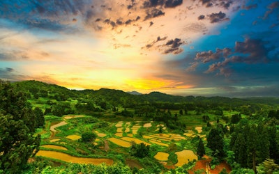
Hoshitoge Rice Terraces: Video Introduction This video, titled "[4K] [Original Scenery of Japan] Rice Terraces at Hoshitoge, Tokamachi, Niigata Prefecture" ([4K]【日本の原風景】新潟県十日町星峠の棚田。雲海と光芒。), was uploaded by "KYODO NEWS." In the video, you can see footage of the Hoshitoge Rice Terraces, which were selected by foreign tourists as the #1 bucket list view in Japan. The reflections on the water-filled rice fields and the sea of clouds that looks different throughout the day are captured in this beautiful 4K video. You can't help but be moved by these views. The video is accompanied by closed captions with tourist information, so be sure to turn them on while watching the video! Rice Fields in Japan Cultivation of rice fields in Japan is believed to have started during the Yayoi Period (300 BC - 250 AD). Rice has played an important role in the history of Japan, and has even been used historically as currency by farmers to pay taxes. Today, rice is a staple food in Japan, and while the exact number of rice fields in Japan is not known, according to the Ministry of Agriculture, Forestry and Fisheries, rice paddies account for 5.85 million acres of land. With Japan having a total landmass of 93.4 million acres, this means that more than 6% of Japan is rice paddies. Despite rice fields being made to grow rice, there are many places in Japan where you can see rice field art, such as Saitama and Aomori prefectures. The use of different colors of rice allows farmers to create incredible images inside the fields. Some other famous rice fields in Japan where you can see breathtaking views include the Shiroyone Senmaida Rice Terraces of Ishikawa Prefecture, the Maruyama Senmaida Rice Terraces of Mie Prefecture, and many more. Terraced rice fields prevent erosion, runoff, flooding, and other undesirable conditions, which is why they are often used in rice farming. Furthermore, they help nurture the land by allowing the water in the fields to slowly seep back into the ground, replenishing the groundwater. What Are the Hoshitoge Rice Terraces? Discover the Beautiful Scenery of Tokamachi, Niigata Photo:The Hoshitoge Rice Terraces of Tokamachi, Niigata Located in Tokamachi, Niigata, in Japan's Koshin'etsu region, the Hoshitoge Rice Terraces, numbering some 200 paddies, are spread across the hillside. Among the terraced rice fields scattered throughout the region, the Hoshitoge Rice Terraces are considered exceptionally beautiful. Depending on the weather and time of year, a sea of clouds and mirror-like water can also be seen at the rice terraces, making this a popular tourist spot with a variety of views. The Hoshitoge Rice Terraces have attracted attention both in Japan and overseas, as they were featured in the opening scene of NHK's historical drama "Tenchijin" (Heart of a Samurai) in 2009, and was recognized as a Japanese heritage that transcends borders by the Ministry of Agriculture, Forestry and Fisheries in 2022. The Hoshitoge Rice Terraces, a place where you can view the beautiful landscapes of Japan, are historic terraced rice fields created by the residents of Hoshitoge village more than 300 years ago. The area, including the village, has been selected as one of the "Top 100 Villages in Japan," and is one of Japan's leading scenic attractions. The Best Season to Visit the Hoshitoge Rice Terraces Photo:A sea of clouds over the Hoshitoge Rice Terraces, Tokamachi, Niigata One of the highlights of Hoshitoge Rice Terraces is the breathtakingly beautiful sea of clouds and mirror-like pools of water covering the fields. Unfortunately, the sea of clouds and mirror-like pools can only be seen during certain times of the year and under certain conditions. In addition, in order to capture the beautiful scenery in photographs, it's important to know in advance the best places to take photographs, so be sure to check before you visit. The best seasons for seeing a sea of clouds is during spring (late June) and autumn (mid-September). During these seasons, a sea of clouds is more likely to occur, and photographers from all over Japan flock to the area to enjoy the spectacular view. On the other hand, the best season for viewing the mirror-like pools is spring (around May to June) and autumn (around October to November). If you want to see both a sea of clouds and the mirror-like pools, be sure to visit in June. However, whether or not you can see a sea of clouds and a water mirror depends entirely on luck. The view in front of you will change depending on the conditions of the day. You will need some luck to take a good picture. However, if the conditions are right, you will be able to see a glowing sea of clouds or a scene enveloped in fog, and you will be able to capture a miraculous shot. Spring, Summer, Fall & Winter: Seasonal Views at the Hoshitoge Rice Terraces Photo:The Hoshitoge Rice Terraces covered in snow, Tokamachi, Niigata The Hoshitoge Rice Terraces are a beautiful sight in each of Japan's four seasons. In addition to the popular sea of clouds and mirror-like pools, you can enjoy colorful cherry blossoms in spring. In the summer, the rice terraces turn a deep green color and contrast with the bright blue sky. In autumn, the ears of rice shimmer with a golden glow, and in winter snow takes the place of water, creating a unique scene of pools of white snow. That being said, cars and motorcycles are unable to access the rice terraces when the snow gets too deep, and you may not be able to visit the rice fields during the winter. The Hoshitoge Rice Terraces also offer a different view during the daytime and at night. In particular, at sunrise and sunset, you can enjoy a beauty that is beyond words, no matter what season you visit in. Summary of the Hoshitoge Rice Terraces The Hoshitoge Rice Terraces are one of the most famous scenic views in Japan. It's a bucket list location, so if you're interested in visiting, we highly recommend adding it to your Niigata travel itinerary! To get to the Hoshitoge Rice Terraces in Tokamachi, Niigata, take the train to Matsudai Station and from there, it's about 20 minutes by taxi. For details on parking and directions, please check here. The rice terraces in Tokamachi, Niigata, including the Hoshitoge Rice Terraces, are not designed for the purpose of sightseeing. They are agricultural land that local people have inherited from their ancestors and carefully preserved. They are also private plots of land where farmers still cultivate rice. In addition to not entering the terraces, it's strictly prohibited to interfere with farm vehicles, take unauthorized photographs of farm work, or leave trash in the terraces. Please enjoy the spectacular scenery while observing proper manners and abiding by the rules. 【TripAdvisor】Hoshitoge Rice Terraces -
 Video article 8:51
Oze National Park Travel Guide: Discover Hiking Trails and the Nature of Oze, Fukushima + Learn How to Get to Oze National Park From Tokyo!
Nature Travel- 115 plays
- YouTube
The Skunk Cabbage of Oze National Park in 2022: Video Introduction This video, titled "The Skunk Cabbage of Oze Marsh, 2022|A Skunk Cabbage Colony in the Shimono Ohori River" (2022 尾瀬の水芭蕉 尾瀬ヶ原 下の大堀川ミズバショウ群生地), was uploaded by "Northen Japanese Alps Nature Video." The bright landscape of Oze National Park, introduced in the nine minutes of video, is as beautiful as an impressionist painting. In the video, taken on May 29th, 2022, you can see there is some snow left on the surface of Mt. Shibutsu (至仏山, Shibutsuzan) and the majestic mountain can be seen towering against the blue sky. Fully bloomed skunk cabbages sway in the wind on the vast marshland at the foot of Mt. Shibutsu. The abundance of water in Oze National Park is also home to frogs and other creatures and you can even hear frogs, a sound you won't hear in the cities. Walking along the boardwalk of Oze Marsh (尾瀬ケ原, Ozegahara) while listening to the bubbling of the Shimono Ohori River (下ノ大堀川 Shimono Ohori River) is therapeutic. Oze, a Place Whose Beauty is Sung About in Traditional Japanese Songs Photo:Oze National Park The beauty of Oze is no secret to the people of Japan, and it has even been featured in traditional Japanese songs dating back to the 1940s. But for those of us not familiar with Oze, here's a quick introduction. Oze is a plateau that straddles the four prefectures of Fukushima, Niigata, Gunma, and Tochigi. Oze is a basin surrounded by 2000-meter-tall mountains, such as Mt.Shibutsu (至仏山, Shibtsusan), Hiuchigatake (燧ヶ岳, Hiuchigatake), Mt. Keizuru (景鶴山, Keizuruyama), and Mt. Nakahara (中原山, Nakaharayama). The marshland centering on Oze Marsh, which is said to have been formed around 10,000 years ago, was designated as Oze National Park (尾瀬国立公園 Oze Kokuritsu Koen) in 2007 and as such, the terms "Oze" and "Oze National Park" are synonymous with one another. Oze National Park is a major scenic spot that has been selected as one of the Top 100 Views of Japan. Other than the marshland of Oze Marsh, many ponds and swamps can be seen on the nearby mountainsides. After the snow melts in May, all the plants and trees bloom at once. There are boardwalks and benches as well, so visitors can enjoy a refreshing walk while taking in all of the natural scenery. The Skunk Cabbage of Oze National Park – A Treat for the Eyes Photo:Skunk cabbage Asian Skunk Cabbage is characterized by its large white petals, but these white petal-like things are not actually petals, rather, they are bracts, which are specialized leaves. Skunk Cabbage is called "Mizubasho" in Japanese (水芭蕉, lit. 'Water Banana'). The name comes from the shape of its leaves, which resemble those of the Japanese banana plant, and from the fact that it grows near water. It's a perennial plant of the arum family that grows in mountainous marshlands, and its flowers are at their best from late May to mid-June in Japan. Although bloom dates are dependent on the amount of snowfall each year, the best time to see skunk cabbage in Oze National Park is the same; late May to early June. In the first week of June especially, Oze National Park is crowded with tourists looking to see the clusters of skunk cabbage in bloom. The Nature of Oze National Park & 2 Popular Hiking Courses in the Area There are many hiking courses in Oze National Park, but the two most popular hiking courses are the Ozegahara Course and the Ozenuma Course. These two courses are recommended for first-time visitors to Oze National Park. Incidentally, the hiking course introduced in the video is the Ozegahara Course. Photo:Ozegahara ●Ozegahara Course This course circles Oze Marsh, the largest marshland on Japan's mainland. The boardwalk is well maintained, so even beginners can walk the course with ease. [Main route] Hatomachi Toge (鳩待峠, Hatomachitoge)→ Yamanohana Visitor Center (山ノ花, Yamanohana)→ Kamino - Ohori River (上ノ大堀川, Kamino Ohori Kawa)→ Ushikubi (牛首, Ushikubi)→ Miharashi (見晴, Miharashi)→ Ryugu Hut (龍宮小屋, Ryugu Goya) (Overnight stay). ※If you're visiting on a day trip, turn back at Kamino - Ohori River or Ushikubi. Ryugu Hut→ Miharashi→ Akatashiro Branch (Akadashiro Bunki)→ Yoppi Suspension Bridge (ヨッピ吊橋 Yoppi Tsuribashi)→ Ushikubi→ Yamanohana Visitor Center→ Hatomachi Toge [Video] 1:28 - Walkers on a Well-Maintained Wooden Path Photo:Oze Marsh and Hiuchigatake ●Ozenuma Course This is a hiking course around Lake Ozenuma and it's the course with the least amount of inclines and declines. Although this course can be hiked on a day trip, it's recommended that you stay overnight at a lodge. Lake Ozenuma at sunset with the stars in the night sky makes for an unforgettable experience. The Numayama Pass Observation Deck (沼山峠展望台, Numayama Toge Tenboudai) is located at the end of a conifer forest uphill from the Oze Numayama Pass bus stop. Here you can enjoy a panoramic view of Lake Ozenuma. On the first day, go to Sanpeishita (三平下) via the east bank of Lake Ozenuma. From Sanpeishita, you can see Hiuchigatake (燧ヶ岳, Hiuchigatake) and Lake Ozenuma, making it a popular vantage point. On the second day, start from the south bank of Lake Ozenuma to Numajiri (沼尻, Numajiri). Numajiri is also a beautiful place with ponds and in spring and summer, you can see pygmy water-lilies and Japanese thistle. After passing through the north bank of Oze Marsh, return to Numayama Pass. [Main route] Numayama Pass→ Ozenuma Villa (Overnight stay) Ozenuma Villa→ Numajiri→ Oze Marsh→ Numayama Pass Hotels, Hot Springs, and Where to Eat Near Oze National Park Photo:The Hatomachi Toge Rest Area The Hatomachi Toge Rest Area is located at Hatomachi Toge, the starting point of Ozegahara in Gunma Prefecture. Many tourists use this spot to prepare before hiking and to eat. The Hanamame Soft Cream ice cream is also popular. For visitors to Oze National Park, we recommend the Sky Terrace (天空テラス, Tenku Terasu) located 2,000 meters above sea level and the free Foot Bath in the Sky (天空の足湯, Tenku no Ashiyu). It takes about 15 minutes by the Nikko Shiranesan Ropeway (日光白根山 Nikko-Shirane San) to reach the summit station. Located on the border with Nikko, Tochigi, you can relax while enjoying a view of Mt. Nikko-Shirane. At Oze Katashina, a roadside station in Tone, Gunma Prefecture, visitors can enjoy direct sales of fresh highland vegetables from Katashina Village (片品村, Katashina Mura), as well as delicious meals prepared using locally grown vegetables at Katashina Diner (かたしな食堂, Katashina Shokudo)" and "Village People's Kitchen (村民キッチン, Sonmin Kicchin)." If you are considering staying near Oze National Park, Oze Hut (尾瀬小屋 Oze Koya) is another great spot we recommend. Despite the name of "hut," it's clean and has excellent facilities, such as the Oze Hut Terrace (尾瀬小屋テラス Oze Koya Terasu), which is open to outside visitors, as well as hot springs. The food is so good that it's hard to believe that it's located in the middle of Oze Marsh. How to Get To Oze National Park From Tokyo From Tokyo there are several ways to get to Oze National Park and there are also several different trailheads to enter the park from. From Tokyo, the easiest entry to the park via public transportation is the Hatomachi Toge trailhead. Tokyo Station to Oze National Park: Hatomachi Toge Trailhead From Tokyo Station, take the Joetsu Shinkansen to Jomokogen Station (1 hr. 10 mins), from Jomokogen Station, take a Kan'etsu Bus to Numata Station (25 mins), from Numata Station, take a Kan'etsu Bus to Togura Station (1 hr. 15 mins), and from Togura, once more take a Kan'etsu Bus to Hatomachi Toge (35 mins). In total it will take approximately 4 hours to reach the Hatomachi Toge trailhead from Tokyo Station. Keep in mind that this is just one route and there are many different trailheads with which to start a hike in Oze National Park. Summary of Oze National Park's Charming Skunk Cabbage Oze National Park is the largest high-altitude marshland on Japan's mainland, and straddles the four prefectures of Fukushima, Niigata, Gunma, and Tochigi. Because of its vast geographical area, you can enjoy the nature of Oze with both hiking and overnight stays. When the short summer comes, various flowers bloom in Oze National Park. From late May to June in particular, when skunk cabbages, the representative flower of Oze National Park, are in bloom, many people visit Oze National Park to see the beautiful scenery. We hope this article can help you enjoy your trip to Oze National Park. Be sure to follow the hiking courses introduced above if you visit! 【Trip Advisor】Oze Marsh -
Video article 5:07
Konzoji Temple - Discover Autumn in Kyoto at This Hidden Gem
Travel Art & Architecture Nature- 31 plays
- YouTube
Konzoji Temple - A Scenic Location in Kyoto in 4K This video, titled "[4K] Concept of OKU, KONZO-JI Temple of Kyoto" ([4K] Concept of OKU, KONZO-JI Temple of Kyoto ”奥” 金蔵寺 京都の寺), was uploaded by "Yurara Sarara," a channel that introduces Japanese culture through video. It introduces Konzoji Temple located in Oshioyama, Kyoto. Kyoto's Konzoji Temple, shown in the video, was built during Japan's Nara period (710-794 AD) as a temple of the Tendai sect of Buddhism. Later, it was destroyed by fire during the Onin War, but was rebuilt by Keishoin, the mother of the 5th Tokugawa shogun, Tokugawa Tsunayoshi, during the Edo period (1603-1868 AD). Enjoy the beautiful appearance of the temple in this short, 4K video. Konzoji – A Mountain Temple Full of Beauty Photo:Beautiful greenery at Konzoji Temple, Kyoto Konzoji Temple is located in the Rakusai area of Kyoto, on the hillside of Mt. Oshio, a mountain with an elevation of 642m. During the Heian period (794-1185 AD), it was called "Iwakura of the West" and is said to have been revered by people. One of the best places to visit in Konzoji Temple is the 12-meter-tall "San no Taki" (産の滝), a waterfall that can be seen at 1:13 in the video. The name "San no Taki" (産の滝: lit. "waterfall of birth") comes from the fact that Mukojin, the deity of Muko Shrine, was born near this waterfall. The next thing to see at Konzoji Temple is the many halls on the temple grounds. The main hall of Konzoji Temple was reconstructed during the Edo period (1603-1868) by Keishoin and houses the eleven-faced thousand-armed Kannon statue, the principal deity of the temple. The Kaizando Hall is a magnificent hall made of all-cypress and enshrines successive generations of priests including Zen Master Takatoyo, the founder of Konzoji Temple. Behind the main hall of Konzoji Temple, there's the Atago Gongen Hall, which enshrines Atago Gongen, and houses a statue of the Jogun Jizo (勝軍地蔵), a jizo said to be able to defeat an army. The statue of the Jogun Jizo is enshrined in this hall, which is open only during the Buddhist memorial service held on April 23 every year. Furthermore, Konzoji Temple has an observatory, and if you head east from Shimonogawa Benzaiten (下の川弁財天, a small shrine), you can enjoy an observatory with a panoramic view of Kyoto City. We recommend checking out the view when visiting the temple. Konzoji Temple - A Hidden Gem for Enjoying Autumn Leaves! Photo:Autumn leaves at Konzoji Temple, Kyoto Konzoji Temple is rarely visited by people, and the people you do see there are usually those who enjoy hiking. However, in early summer, there is a lot of greenery and it is a very pleasant spot to take a leisurely tour of the temple grounds. Konzoji is also known for the beauty of the green maple leaves, and it is the perfect place to experience the nature of Japan. Konzoji Temple also takes on a new appearance during the autumn months. The beautiful autumn colors that can be seen here have turned the temple into a hidden gem for viewing the breathtaking foliage of the season. Because it's located on the mountainside, the temperature varies greatly between morning and evening, and it's a great place to enjoy the spectacular autumn leaves. In particular, the path from Nio-mon Gate to the main hall is surrounded by autumn leaves creating a sort of tunnel of foliage, and is famous locally for its eye-catching beauty. Konzoji Temple is a tourist spot where you can enjoy beautiful greenery in the summer and orange and red autumn leaves in the fall. There is a parking lot you can use when accessing Konzoji Temple via car, but please note that there are some steep roads. When coming by bus, it's about an hour on foot as the nearest bus stop is quite far. That being said, if you're looking to get some hiking or exercise in, or just want to explore something new, this is definitely a place to check out. Summary of Kyoto's Beautiful Konzoji Temple As introduced in this article, Konzoji Temple is a place where you can enjoy the beautiful nature of Japan. In addition, many Shigaraki ware tanuki (raccoon dogs) figures can be found in the area, and the figure of a tanuki enjoying sake is becoming popular as an Instagram icon. The quaint appearance of the halls standing amongst the green maples expresses the beauty of Japan. In autumn, these trees turn breathtaking shades of red and orange, and visitors can enjoy the natural beauty created by the autumn leaves. Consider visiting Konzoji Temple, a place where you can enjoy the beauty of Japan in each of the four seasons! 【Tripadvisor】Konzoji Temple https://www.tripadvisor.com/Attraction_Review-g298564-d1386185-Reviews-Konzoji_Temple-Kyoto_Kyoto_Prefecture_Kinki.html -
Video article 3:22
Beautiful Aerial Views of Isshiki Beach in Zushi and Hayama! Check Out One of the World's Top 100 Beaches That Can Be Reached on a Day Trip From Central Tokyo!
Nature- 92 plays
- YouTube
Isshiki Beach in Zushi-Hayama, Kanagawa This video, titled "Zushi, Hayama [Isshiki Beach] Drone Footage, 4K, Drone, Japan|HAYAMA ZUSHI" (逗子・葉山【一色海水浴場】ドローン空撮 4K Drone Japan HAYAMA ZUSHI), was uploaded by "Drone Man sky creative" (ドローン男子 sky creative). It introduces Isshiki Beach in the Zushi-Hayama area of Kanagawa Prefecture, located in Japan's Kanto Region, via drone footage. The video gives a unique view of Isshiki Beach that you wouldn't normally see, that is, from the sky. We hope you enjoy it! More About Isshiki Beach in Zushi-Hayama, Kanagawa! Photo:Isshiki Beach, Zushi-Hayama Isshiki Beach is a serene beach measuring 500m long and 30m wide facing Sagami Bay in Hayama, a resort area on the Miura Peninsula in Kanagawa Prefecture. It's a beautiful beach that extends to the backside of the Hayama Imperial Villa, a villa of the Imperial Family, and was selected as one of the "100 Best Beaches Around the World" by CNN in 2013. It's also a popular spot for surfing and SUP, and you can see many people enjoying marine activities, water sports, swimming, and sunbathing in the video. In the vicinity of Isshiki Beach is Arasaki Park, the #1 scenic spot on the Miura Peninsula, where you can get a great view of Mt. Fuji and beautiful sunsets! Isshiki Beach is a must-visit tourist spot when visiting the Isshiki area. The beach is easily accessible on a day trip from Tokyo, and is crowded with families swimming and sunbathing on sunny days. There are rocks on both sides of the beach where visitors can enjoy playing on the rocks. You can see the rocky beach from 1:42 in the video. During beach season, lifeguards are stationed at beach houses, so there's no need to worry about safety. The beach houses are rated highly on review sites for being very stylish and having great atmospheres. Lunch and showers are available at the beach houses as well. Unfortunately, the beach has been temporarily closed due to the novel coronavirus, so be sure to check in advance when visiting. Speaking of beaches and swimming, one of the things you might be wondering about is whether or not barbecues are allowed. Unfortunately, Isshiki Beach prohibits barbecues within the summer beach area. That being said, it is possible to have a barbecue a short distance away from the beach, but it is not permitted near residences. Information on Events and Activities Held at Isshiki Beach Photo:Beach yoga A variety of events are held at Isshiki Beach in the Zushi-Hayama area of Kanagawa. One such event is Feel SHONAN during Beach Yoga Week, where participants can experience authentic, relaxing beach yoga. Participants say that beach yoga at Isshiki Beach makes them feel like they are one with nature. In summer, the Hayama Kaigan Fireworks Festival is held, attracting many visitors annually. The Hayama Kaigan Fireworks Festival is held every year from late July to early August at Morito Beach and the Isshiki Beach Breakwater. At Isshiki Beach, sea kayaking, a type of canoeing, is a popular activity. Fishing is also popular, and anglers can catch flatheads and Japanese whiting. Sightseeing Information and Instagram Photo Tips for Isshiki Beach Photo:Morito Daimyojin Shrine, Hayama, Kanagawa The Zushi-Hayama area of Kanagawa is home to many tourist attractions. If you like visiting shrines and learning about the history of places you visit, we recommend checking out Morito Daimyojin, a shrine founded by Minamoto no Yoritomo that's visited by many people each year to pray for successful pregnancy and safe childbirth. If you're looking to enjoy a Japanese garden or a tea house, there's also Hayama Shiosai Park. We also recommend Hayama Ajisai Park, where visitors can see 3,000 colorful hydrangeas, and Hayama Sangaokayama Ryokuchi, where visitors can enjoy hiking. Hayama Marina, where visitors can enjoy cruising around Enoshima and Yujiro Lighthouse, is also popular. Summary of Isshiki Beach in Zushi-Hayama In this article, we introduced Isshiki Beach, one of the best beaches in Japan. The beach is just an hour and a half from Tokyo, and as you can see in the video, it features beautiful cobalt blue waters. Enjoy a relaxing time at Isshiki Beach in the Zushi-Hayama area of Kanagawa this summer! ◆Isshiki Beach◆ 【Address】Isshiki, Hayama, Miura, Kanagawa 【Access】From Zushi Station (JR Yokosuka Line) or Hayama Station (Keihin Kyuko Line), take the Keikyu Bus bound for Kaigan-mawari Hayama, and get off at the Isshiki Kaigan bus stop (20 minutes) By car, it's about 20 minutes from the Zushi Interchange on the Yokohama–Yokosuka Road via the Zushi Shindo toll booth (逗葉新道料金所). 【Parking】Parking available for 30 cars. Weekdays: 1,500 yen, Weekends: 2,000 yen 【TripAdvisor】Isshiki Beach https://www.tripadvisor.com/Attraction_Review-g1121132-d7652968-Reviews-Isshiki_Beach-Hayama_machi_Miura_gun_Kanagawa_Prefecture_Kanto.html -
Video article 8:06
Learn About the White-Tailed Eagle's Ecosystem and More. See It Soaring Through the Skies Above the Nemuro Strait in Hokkaido, Japan
Living Things Nature- 74 plays
- YouTube
White-tailed Eagles in the Nemuro Strait of Hokkaido, Japan: Video Introduction This video, titled "White-tailed Eagles" (オジロワシ), was uploaded by "Gaiapress Channel." Along with footage of white-tailed eagles living in Hokkaido, it provides detailed explanations of their ecosystem. It's a great opportunity for those interested in nature and the birds of Hokkaido to learn more about the area. Be sure to read on to learn more. The White-tailed Eagle Photo:A white-tailed eagle The white-tailed eagle is a bird belonging to the Accipitridae family and the Pandionidae genus. It lives near coastlines, rivers, and lakes, and is often found alone or in pairs. It is a carnivore and feeds on fish, birds, mammals, animal carcasses, young hares, and quail chicks. [Video] 0:12 - The White-tailed Eagle The white-tailed eagles’ size ranges from 80cm for males to 94cm for females, with a wingspan of 180-220cm. They have a distinct call, with males making a "gri-gri-gri" sound and the females a "gra-gra-gra-gra" sound. White-tailed eagles that breed in northern Eurasia migrate to areas around China and the Persian Gulf for the winter. In recent years their breeding rate has decreased, and they have been designated as a domestic endangered wild animal species, as well as a protected species since 1970. The Habitat of White-Tailed Eagles and Where to See Them in Japan Photo:A white-tailed eagle catching a fish On the Nemuro Peninsula, located between the Shiretoko Peninsula and Kunashir Island, you can see drift ice that has drifted southward from the Amur River. In the video, you can see white-tailed eagles on the drift ice as well. [Video] 0:27 - White-tailed Eagles on Drift Ice The natural habitat of white-tailed eagles is Eurasia, Europe and East and West Asia. In Japan, they mostly migrate to northern Japan, and in Hokkaido, they breed in small numbers. It takes 6-7 years for white-tailed eagles to become fully mature birds. When they are young, they have brown tail feathers, but when they become adults, their tail feathers turn white and their beaks turn yellow. Feeding Habits of Japanese White-Tailed Eagles In the video, you can see white-tailed eagles congregating, targeting fish lurking under the sea ice. The Nemuro Strait is home to a thriving pollock population, and white-tailed eagles gather there to take advantage of the abundant supply of pollock. [Video] 2:07 - A White-Tailed Eagle Stalking a Walleye Pollack Birds of the hawk family that feed primarily on fish are called sea eagles. White-tailed and Steller's sea eagles are typical examples of sea eagles, and salmon and cod are their favorite catch. You can see them preying on them in the video. [Video] 2:43 - A White-Tailed Eagle Feeding White-tailed Eagles and Steller's Sea Eagles Occupying the Nemuro Peninsula On the Nemuro Peninsula, coastal areas where fishing is carried out are inhabited by crows and seagulls, but about 6 miles offshore, there are birds of prey such as white-tailed eagles and eagles. White-tailed eagles occupy and settle down in favorable locations, such as high places with good visibility or suitable winds in snowy weather. A Group of White-Tailed Eagles Flying Above a Nest Photo:A white-tailed eagle flying through the skies In the video, you can see a group of white-tailed eagles gathering in the mountains. Their nest is located in a place far from the sea. [Video] 4:25 - White-tailed Eagles Gathering in the Mountains "Kettle" is the word used to describe a group of eagles or hawks rising together like a thermal updraft and flying into the sky. In the case of white-tailed eagles, they also form "kettles" regardless of migration. One of the characteristics of white-tailed eagles is that multiple adult birds can be found perching on one tree. [Video] 4:49 - A Kettle of White-tailed Eagles Facts About White-tailed Eagles and Their Vision The video also talks about the white-tailed eagle's vision. White-tailed eagles are known for their narrow upward sight, and it's believed that their eyes do not work in situations with little contrast, such as snowstorms. [Video] 6:05 - Regarding the Sight of White-tailed Eagles White-tailed eagles are also known to fatally crash into wind turbines. Most accidents involve hitting a wind turbine from above, which seems to be related to the narrowness of their visual field. Such accidents are commonly known as "bird strikes." Difference Between White-tailed Eagles and Steller's Sea Eagles Photo:Stellar's sea eagles eyeing fish from above the drift ice The bird with white shoulders is the Steller's sea eagle, and the bird that looks brownish all over is the white-tailed eagle. Both are large birds of prey that have wingspans over 2 meters when fully spread. If you visit the Nemuro Peninsula for sightseeing, you'll now be able to tell the difference with this information! [Video] 0:51 - White-tailed Eagles and Stellar's Sea Eagles White-tailed eagles, have many similarities to Stellar's sea eagles, such as not being susceptible to avian influenza. However, there are differences in minor details, such as the fact that they move in flocks and have gentle personalities. Summary of White-tailed Eagles Hokkaido, where this video was shot, is home to a variety of wildlife and plants. On the Nemuro Peninsula, in addition to white-tailed eagles and Stellar's sea eagles, there are also tours for bird watching. You can see wild birds such as the red-crowned crane, the red-flanked bluetail, and the hazel grouse. Take a trip to the wilderness of Hokkaido and enjoy bird watching in winter! -
Video article 2:12
Okuzure Suisenkyo – Beautiful Lakeside Views and a Daffodil Festival in a Quiet Japanese Town in Chiba via Video. Learn The Best Season to Visit and More!
Nature Travel- 28 plays
- YouTube
Okuzure Suisenkyo, Chiba Prefecture: Video Introduction This video, titled [HD] Chiba Prefecture, Kyonan 'Okuzure Suisenkyo' Daffodil Garden | Famous Flower Spot in Peak Season" ([HD]千葉県・鋸南町「をくづれ水仙郷」Daffodil Garden 花の名所 花見頃), was uploaded by "Discover Nippon." Kyonan, located on the Boso Peninsula in Chiba prefecture, is home to two famous daffodil spots - Okuzure Suisenkyo, (lit. Okuzure Narcissus Township) and Ezuki Narcissus Road, (江月水仙ロード), earning it a place as one of the "Top 3 Daffodil Colonies in Japan." The name "Okuzure" (をくずれ, sometimes romanized as "wokuzure") uses an unconventional spelling and is said to come from a dialectical pronunciation of local place name "Okuzure" (大崩, おくずれ, romanized as "okuzure"). Okuzure Suisenkyo, is a colony of daffodils stretching from Sakuma Dam's lakeside to the Okuzure area. Nurtured by an abundance of natural light, the gorgeous sight of the pretty, white daffodils blooming along the river makes this a superb sightseeing location. Between late December and late January (the peak of the daffodil season) a yearly "Daffodil Festival" (水仙まつり, suisen matsuri) is held at Okuzure Suisenkyo, At night there are illuminations, giving the festival a different atmosphere compared to daytime. Be sure to take a look at the mystical scenes produced by the daffodils blooming along the lakeside in the video. [Video] 0:00 - Sakuma Dam Lakeside Area Daffodils What Makes Okuzure Suisenkyo, Special? When to Visit? Photo:Daffodils at Okuzure Suisenkyo The town of Kyonan in Chiba Prefecture is listed alongside Awaji Island (淡路島, awaji-shima) of Hyogo and Fukui's Echizen Coast (越前海岸, echizen kaigan) as one of the "Top 3 Daffodil Colonies in Japan." Encompassing around 2.2 kilometers of land, the space between Sakuma Dam and the Okuzure area is known as Okuzure Suisenkyo, and is best visited between late December and late January, when the area is covered in daffodils as far as the eye can see. With every rice paddy in the area being of the terraced variety, the embankments that make up this beautiful scenery and the slopes at the mountain's foot provide rich soil for some 60 million daffodils over a vast area of approximately 12 acres. During the peak season at Okuzure Suisenkyo, from mid-December to mid-January, a direct delivery service is offered to ship daffodils nationwide so that people can enjoy the elegant flowers and fragrance of daffodils at home. In January of each year, when the daffodils are at their best, Okuzure Suisenkyo, and Ezuki Narcissus Road play host to the Daffodil Festival, complete with illuminations. [Video] 0:00 - Sakuma Dam Lakeside Area Daffodils [Video] 2:07 - Sakuma Dam Lakeside Ezuki Narcissus Road, a Popular Hiking Trail + Daffodil Festival Illuminations, Events, and More! Source :YouTube screenshot Minamiboso is known for its warm climate, as expressed by an old saying "You don't need a single piece of underwear once you crest Mt. Nokogiri." Even during fierce winters with their westerly winds (westerlies in Japan bring cold air from Siberia over the country), thanks to a distribution of high pressures in the west and low pressure to the east inland, temperatures in the area remain relatively mild. Thanks to these weather conditions, daffodils from Kyonan are deeply scented and grow very tall. Okuzure Suisenkyo, and Ezuki Narcissus Road are popular daffodil spots in Kyonan. Okuzure Suisenkyo is a 2.2-km area stretching from the Sakuma Dam area to the Okuzure area. Ezuki Narcissus Road refers to a road in the Ezuki area fringed for 3 kilometers on both sides by daffodils. A 30–40 minute walk each direction, the road is a popular hiking trail. Enjoy a stroll accompanied by a lovely view and the welcoming scent of the daffodils blooming along the road. Each year in January, just as the daffodils begin to bloom, the Daffodil Festival is held at Okuzure Suisenkyo, and Ezuki Narcissus Road, attracting large numbers of tourists. During the daffodil festival a variety of activities are available, including "mochitsuki" (a Japanese tradition of pounding rice into a stretchy, sticky confection known as "mochi"), vegetable stores open, and events, such as stamp rallies, take place as well. At the shops lining the road, visitors can purchase daffodils in addition to the vegetables for sale. Sakuma Dam Park located on Ezuki Narcissus Road is the stage for a light show at night-time, and the daffodils appear to rise up out of the night, making for an ethereal spectacle. [Video] 1:47 - Daffodils and Illuminations Enjoy Cherry Blossoms in Spring at Sakuma Dam Lake Park Photo:Kawazu cherry blossoms at Sakuma Dam Lake Park Located on the shores of Sakuma Dam's reservoir lake, Sakuma Dam Lake Park (佐久間ダム湖親水公園, sakuma damuko shinsui koen) is known not only for its daffodils, but for its cherry blossoms too. Between early February and early March the Yoritomo cherry blossoms (also known as Kawazu sakura) bloom, followed by Yoshino cherries from late March to early April, and multi-layered cherry blossoms (八重桜, yae-zakura) from mid to late April, with a "Yoritomo Cherry Blossom Festival" (頼朝桜まつり, Yoritomo Sakura Matsuri) and "Cherry Blossom Festival" (桜まつり, Sakura Matsuri) being held accordingly. Be sure to enjoy mountain dyed pink by the beautiful cherry blossoms in spring. In the vicinity of Sakuma Dam, the daffodils start to bloom as early as December, and as the season comes to an end in February the early-blooming Yoritomo cherry blossoms begin to flower, making it possible to experience a rare duet of daffodils and cherry blossoms. You can enjoy flowers at Sakuma Dam Lake Park at their best from winter, when the daffodils bloom, right through the cherry blossom season in the spring. Okuzure Suisenkyo, Chiba Prefecture: Roundup The "Daffodil Festival," held at one of the "Top 3 Daffodil Colonies in Japan," Okuzure Suisenkyo, and Ezuki Narcissus Road, have highlights aplenty, offering not only gorgeous views of daffodils, but also illuminations, and a variety of other events. A field of daffodils stretching as far as the eye can see would make a pretty good phone background to keep as a reminder of this year's winter. Don't you think? 【TripAdvisor】Narcissus Road -
Video article 4:21
Fuji - Japan's Largest Tourist Attraction and the Pride of the Country. Its Mysterious Beauty Fascinates All Who See It
Nature- 186 plays
- Vimeo
An Introduction to Mt. Fuji This video is “Mount Fuji | A Time-lapse Film 4K,” made by Daisuke Shimizu. It is a 4K time-lapse of Mt. Fuji. Mt. Fuji is the highest mountain in Japan at 12,000 feet tall, spanning both Shizuoka and Yamanashi Prefectures. Since long ago it has been an object of worship under the name “Reihou Fuji.” In 2013 it was registered as a World Heritage Site, and it has become a famous mountain visited by more than 200,00 tourists, both Japanese and international, every year. Mt. Fuji is still an active volcano, but the last time it erupted was about 300 years ago (1707 AD) during the Edo period. This video introduces the beautiful scenery of Mt. Fuji through a 4K time-lapse. The highlights are the flowing, starry sky, the cityscape spreading into the hills, and the reflection of Mt. Fuji on the surface of a nearby lake. Enjoy the charm of the power spot, Mt. Fuji. Mt. Fuji: A World Heritage Site ©Koichi_Hayakawa Modifying Mt. Fuji is a mountain that spans Shizuoka Prefecture (in Fujinomiya CIty, Susono City, Fuji City, Gotemba City, Koyama-town Sunto-gun) and Yamanashi Prefecuture (in Fujiyoshida City and Narusawa-mura Minamitsuru-gun). It is a world-famous mountain that has been selected as one of Japan's "Three Great Mountains," "Japan's Top 100 Geological Sites," and as a World Heritage Site. In the past, Mt. Fuji was feared for its large eruptions and lava spills, and it was considered a mysterious mountain and an object of worship. It is said that when Mt. Fuji's eruptions subsided, trainees began to step into the mountain to gain the divine and spiritual power of Mt. Fuji. Nowadays, the Fujinomiya peak side of Mt. Fuji is home to Sengen Taisha Okumiya who worships Asama no Ookami (浅間大神), also called Konohanasakuyabime, as the main deity. Also, the summit of the Yoshida and Kawaguchi Lake (河口湖, Kawaguchiko) side is home to Kukushi Shrine. The beautiful figure of Mt. Fuji, said to be the symbol of Japan, has been drawn in various art works, such as the famous “Gaifu Kaisei,” drawn by the Japanese ukiyo-e artist Katsushika Hokusai. Mt. Fuji Is Also Popular Abroad! Photo:Mt. Fuji The mountain climbing season at Mt. Fuji differs by trail. Please note that it is completely closed outside of these climbing seasons. ・ Yoshida trail (Yamanashi Prefecture side): July 1 - September 10 ・ Subashiri trail (Shizuoka Prefecture side): July 10 - September 10 ・ Gotemba trail (Shizuoka Prefecture side): July 10 - September 10 ・ Fujinomiya trail (Shizuoka Prefecture side): July 10 - September 10 ・ Ohachi-meguri Trail (The trail of the crater's rim): July 10 - September 10 The trailhead is near the fifth station, and you can take the Fuji-Subaru Line/Fujiyama Skyline to get to it. You can also get there by car or bus. Parking is also available. The time required for climbing differs by trail, but the Subashiri route takes about 5 hours and 40 minutes and descending takes about 2 hours and 30 minutes. The weather on Mt. Fuji, which is 12,000 ft. above sea level, is extremely variable, and the summit of Mt. Fuji may reach subzero temperatures even during the summer. Headlights are also required if you are climbing in the evening. Mountain climbing on a one-day trip is also possible, but if climb to high in a short time, you run the risk of developing altitude sickness, so please be careful. Fuji also has a number of huts, so we recommend that you take a break at them or stay overnight. Please follow the rules and manners, bring sufficient equipment, and avoid taking any unnecessary risks. The Peak of Mt. Fuji in 4K This article's video introduces the beautiful figure of Mt. Fuji through a 4K time-lapse. From 0:08 in the video, You can see Mt. Fuji in the darkness of the night as the morning sun gradually rises. From 1:15, it is possible to see clouds over the snow capped Mt. Fuji, and from 1:33, there's the highlight of the movie, the mysterious and beautiful starry sky over Mt. Fuji. The video shows Mt. Fuji seen from the beach, an upside-down Mt. Fuji floating on the surface of a lake, a night view at the foot of Mt. Fuji, and many more beautiful sceneries. There might be aspects of Mt. Fuji that you have not seen before! Things to Do Near the Sacred Mt. Fuji Photo:Mt. Fuji and autumn leaves seen from Lake Kawaguchi When you visit Mt. Fuji, be sure to check out the sightseeing spots around Mt. Fuji. This article introduces some recommended sightseeing spots around Mt. Fuji, but there are still more. The World Heritage Center, located in Fujikawaguchiko-machi, Minamitsuru-gun, Yamanashi Prefecture, is a hands-on exhibition and tourism facility where you can enjoy the charms of Mt. Fuji. There's also Fujikyu Highland, a popular amusement park, and many hot springs, hotels, inns, and campgrounds, where you can relax after a long day of travel. Also famous is "Oshino Hakkai," "Shiraito Falls, "Narusawa Ice Cave," and the "Fugaku Wind Cave" where you can feel the clear water of Mt. Fuji. These are also popular as some of Japan's leading power spots. In addition, there are many sightseeing spots around Mt. Fuji, such as "Yamanakako Hananotsu Park," "Mishima Skywalk," "Fuji Safari Park Clematis Hill," and "Children's Country." Gourmet foods that we recommend trying are the local Yoshida Udon and Fujito. The Fuji Sanroku Whiskey, made with delicious subterranean water from Fuji, is also popular. Summary of Popular Sightseeing Spots at Mt. Fuji This time we introduced the charm of Mt. Fuji, a world renown mountain and the symbol of Japan. Be sure to check out the video to see the beautiful 4K footage of Mt. Fuji. It truly is amazing. Mt. Fuji, the tallest mountain in Japan, can be seen from different places all over Japan. Definitely keep your eyes peeled when visiting Japan. 【Official Website】Mt. Fuji Climbing Official Website http://www.fujisan-climb.jp/en/index.html -
Video article 7:41
Isonokami Shrine – The Oldest Shrine in Japan. Discover Sacred Swords, and Ancient Amulets at This Shrine Surrounded by a Divine Forest in Kanagawa Prefecture
Travel History- 82 plays
- YouTube
Isonokami Shrine – The Oldest Shrine in Japan: Video Introduction This video, titled "[Nara / National Treasure] Rainy Scenery at Isonokami Shrine in NARA, JAPAN -" (【奈良/国宝】石上神宮 - Rainy scenery of the Isonokami Jingu Shrine in NARA, JAPAN -), was uploaded by "channel WASABI." This video, shot during autumn, shows both the beauty of nature and the divinity of the area. Be sure to check out the video before reading along. Isonokami Shrine – A Brief History of the Shrine Photo:Isonokami Shrine, Tenri, Nara Isonokami Shrine is located in Tenri, Nara, in Japan's Kansai Region, at the western foot of Mt. Ryuo. The haiden (拝殿, hall of worship) is the oldest existing hall of worship in Japan and is designated as a National Treasure. Isonokami Shrine has been worshipped as the ancestral deity of the Mononobe Clan, a powerful clan in the Asuka Period (circa 592-710 A.D.). The shrine is also known for its blessings of health and longevity, its power to heal illnesses, protect from disaster, and fulfill wishes, and is designated as the 19th site on the Shinbutsu Reijo Junpai no Michi, a pilgrimage route to sacred Shinto shrines and Buddhist temples. The pilgrimage route is made up of 152 sacred sites in Japan's Kinki region, including Ise Jingu Shrine. The Gods Worshipped at Isonokami Shrine Isonokami Shrine worships three main deities. Here we'll introduce them briefly. Futsunomitama no Okami – A sword that appears in Japanese mythology. The deity is said to have been inspired by the sword held by Takemikazuchi no Kami, a god of thunder. Furunomitama no Okami – Said to refer to one of the sacred treasures given to Nigihayahi no Mikoto (a god and ancestor of the Mononobe Clan) by Amatsukami Mioya, as well as its mysterious powers. Futsushimitama no Okami – A divine sword used by Susanoo no Mikoto when he defeated Yamata no Orochi, a legendary 8-headed dragon serpent, and the spiritual power of the sword itself. Chickens: Messengers of the Gods at Isonokami Shrine Photo:The sacred chickens of Isonokami Shrine, Tenri, Nara The 30 to 40 chickens at Isonokami Shrine are called goshinkei (御神鶏, lit "sacred chickens") and are designated as a protected species by the Japanese government. They are free-range chickens at Isonokami Shrine and welcome visitors to the shrine. Chickens, which appear in the Kojiki (Records of Ancient Matters) and the Nihon Shoki (Chronicles of Japan), are believed to be messengers of the gods, and their crowing is thought to ward off evil. On the temple grounds, Goshinkei Mikuji (御神鶏みくじ, sacred chicken mikuji), which come in containers shaped like chickens, and ema (wooden prayer plaques) depicting a chicken crowing at dawn, are also popular. [Video] 2:05 - Chickens at Isonokami Shrine Highlights of Isonokami Shrine Photo:Izumo Takeo Shrine at Isonokami Shrine, Tenri, Nara The tower gate, designated as an Important Cultural Property, was built in 1318 in the late Kamakura Period (1185-1333), and in the past, a bell was hung on the upper level of the gate. The space behind the hall of worship, which is the oldest in Japan and is designated as a National Treasure, is a consecrated ground, and serves as a sacred space where the shrine's deities reside. The worship hall of Izumo Takeo Shrine, an auxiliary shrine to Isonokami Shrine, has also been designated as a National Treasure. The historic and solemn atmosphere of the shrine as well as its divine appearance can be seen in the video. [Video] 3:25 - Izumo Takeo Shrine's Worship Hall Seven-Branched Swords, Divine Amulets & More Photo:Isonokami Shrine, Tenri, Nara The seven-branched sword of Isonokami Shrine is an ancient relic that has been handed down within the treasury of Isonokami Shrine. It's assumed to be the same as a sword which was presented by the Baekje people (an ancient Korean kingdom) many years ago. The uniquely shaped sword, measuring 74.8 cm in length, is made of iron and has three "branch" swords on each side. The amulet called Go-shinken Mamori, which represents this seven-branched sword, is said to be a lucky charm with the power to rescue someone on the brink of death. The shrine's shuin stamp also depicts a seven-branched sword. Summary of Isonokami Shrine Isonokami Shrine is known as a power spot and is visited by many people seeking blessings. In addition to Isonokami Shrine, there are many other interesting historical sightseeing spots in Nara Prefecture. If you're planning a visit to Nara, consider visiting Isonokami Shrine as well! 【Official Website】Isonokami Shrine Official Website|Tenri, Nara 【TripAdvisor】Isonokami Shrine -
Video article 1:19
Flowers, Playgrounds and the Sea – Discover the Charms of Uminonakamichi Seaside Park via Video! This State-Run Park in Fukuoka is Fun for All the Family!
Travel Things to Do Nature- 52 plays
- YouTube
Uminonakamichi Seaside Park: Video Introduction This video, titled "Uminonakamichi Seaside Park -Fukuoka- PRvideo 2018 'English version'," was uploaded by "Uminonakamichi Seaside Park." Spanning 6 kilometers from east to west and covering an area of 750 acres, Uminonakamichi Seaside Park (海の中道海浜公園, Uminonaka kaihin koen) is a nature-rich national park surrounded by the sea in Higashi, Fukuoka and is nicknamed "Uminaka." This video shows everything to enjoy at the park; from magnificent aerial views and children playing gleefully on the various playground equipment, to flower fields filled to the brim with blooms. Uminonakamichi Seaside Park: Entrance Fees Photo:Uminonakamichi Seaside Park, Fukuoka City, Fukuoka Prefecture Located in Fukuoka City's Higashi Ward, and bursting with natural beauty, there are many ways to enjoy Uminonakamichi Seaside Park. There is a host of playground equipment, including an adventure course, and the park has received rave reviews not only from locals as a place to go with the kids, but from people living in the surrounding area and visitors to Fukuoka as a superb location for leisure activities. [Video] 0:17 - Various playground equipment Entrance fees are 450 yen per adult (ages 15+), or 290 yen per adult for larger group bookings. A silver ticket (ages 65+) costs 210 yen regardless of group size, and children of middle school age or below can visit for free. The group price applies for groups of 20 or more members for elementary school students and above. There are also tickets available that can be used over two consecutive days. (Prices as of September 2022) Nemophila, Lupinus, Roses – Different Colors in Every Season! When to See the Different Flowers at Uminonakamichi Seaside Park Photo:Baby blue eyes at Uminonakamichi Seaside Park, Fukuoka City, Fukuoka Prefecture There are a plethora of places to view flowers around the park, most notably "Flower Hill" (花の丘, Hana no Oka), Hanasajiki (花桟敷), and the Rose Garden (バラ園, Bara-en), and you can enjoy flowers during all four seasons. The vast 12,000 sqm. flower garden encompassing Flower Hill and the surrounding lawns plays host to nemophila (baby blue eyes) in the spring (best viewing time: April), and in autumn, cosmos (best viewing time: October) cover the area. [Video] 0:41 - Flower Hill: Nemophila in Spring | Cosmos in Autumn The area is full of places to take photos, with Hanasajiki playing host to lupin (which flower in May) and the Rose Garden to autumn roses (best enjoyed in October). If you're an instagrammer or photographer, this is definitely a place to check out! [Video] 0:27 - Seasonal Flwoers at Uminonakamichi Seaside Park|Flower Museum Enjoy a walk through the park and allow the delightful flowers to soothe your soul. You can check the bloom forecast for each of the seasonal flowers on the official homepage as well. A Place Full of Fun and Children's Smiles! Enjoy Cycling and Other Athletic Activities as Well! Photo:The Shiomidai observation deck at Uminonakamichi Seaside Park With go-karts, a mini steam train, F1 battery cars and even a maze, "Wonder World" will keep the kids smiling all day long. The adventure playground, which opened in March 2022, is the first of its kind in Kyushu and ranks amongst the largest in the country. There's a host of exciting activities for people of all ages to enjoy at the gigantic Sea Dragoon tower. If you're an animal lover, Animal Forest (動物の森, dobutsu no mori) natural zoo is a must visit, as it's home to around 50 different species of animals, including capybaras, kangaroos, flamingos, black-capped squirrel monkeys and more, and you can interact with tortoises, goats, and other cute animals at the petting events. [Video] 0:49 - Interact With Cute Animals at the Natural Zoo The park is full of things to see and do, but one of the things we recommend trying is the bicycle service. You can take a bike and ride around the park while enjoying some fresh air. You can rent a mountain bike for 2,500 yen per 3 hours, a city bike for 1,000 yen per 3 hours, or an E-BIKE (electric-assist sports bicycle) for 3,500 yen per 3 hours. (Prices as of September 2022) [Video] 0:57 - Feel the Breeze With Some Cycling Back for 2023 – Summer Fun for Everyone! Marine World's 'Night Aquarium' Photo:Marine World at Uminonakamichi, Fukuoka City, Fukuoka Prefecture Also within the boundaries of Uminonakamichi Seaside Park is "Marine World Uminonakamichi." Following the theme of "Kyushu's Ocean," a variety of sea creatures, including dolphins, sea lions, sea otters, sardines, sea turtles, spotted garden eels, sharks (sand tiger sharks and sandbar sharks) and more are waiting to delight guests. In summer, the "Night Aquarium" opens, and its "Light and Sound Sardine Show" and "Nighttime Dolphin Show," which take place only after dark, allow visitors to enjoy a different atmosphere at the aquarium. The dates for the Night Aquarium are July 15 to July 17 and July 22 to August 31, 2023. It will also take place on Saturdays, Sundays, and holidays from September 1 to September 24. Uminonakamichi Seaside Park: Roundup So much to see! So much to do! Uminoinakamichi Seaside Park has more to offer than can be explored in just one day. It's no surprise that there's a two-day pass available either, as this is a park you'll want to visit time and time again. Get away from the hustle and bustle of the city and enjoy nature's bounty, with beautiful views of the Genkai Sea from the observatory and much more. The kids will love it and it's a great chance for adults to relax and relieve themselves of their day-to-day stress, meaning smiles all around! You can enjoy a picnic or barbecue with a nice sea breeze at the popular day-camping spot nearby, and depending on which plan you choose, everything from the stove to utensils, ingredients, cleanup, and trash collection can be included as part of your stay. The park is easily accessible by train, and there is a toll parking lot for those visiting by car. We highly recommend spending the day here and enjoying a wonderful time out with your family or friends! ◆Uminonakamichi National Government Seaside Park 【Official Website】https://uminaka-park.jp/ 【Address】18-25 Saitozaki, Higashi-ku, Fukuoka 811-0321 【Telephone】092-603-1111 【Admission fee】Adult (15 years and over) \450 | Silver (65 years and over) \210 | Middle-school age and below: Free 【Access】 [By train] For access to Wonder World, Sunshine Pool and Marine World, use JR Uminonakamichi Station (JR海の中道駅, JR Uminonakamichi-eki) (Closest park entrance: Uminonakamichi Station entrance – immediately outside the station). For access to the lawn plaza and Flower Hill, use JR Saitozaki Station (JR西戸崎駅, JR Saitozaki-eki) (Closest park entrance: West Entrance – 10 minutes walking). [By car] Toll parking lots are available (check the official website for further details). 【Official Website】Uminonakamichi Seaside Park | National Government Park Filled With Natural Beauty in Higashi, Fukuoka https://uminaka-park.jp/ 【TripAdvisor】Uminonakamichi National Government Seaside Park https://www.tripadvisor.com/Attraction_Review-g298207-d1423810-Reviews-Uminonakamichi_Seaside_Park-Fukuoka_Fukuoka_Prefecture_Kyushu.html -
Video article 3:09
The Carpet of the Gods – Aerial Footage of Autumn Leaves on Mt. Kurikoma. Experience a Sea of Clouds, Sunrise, and Brilliant Autumn Colors on the Mountain Spanning Miyagi, Iwate, and Akita Prefectures!
Nature Travel- 76 plays
- YouTube
The Carpet of the Gods – Autumn Leaves on Mt. Kurikoma: Video Introduction This video, titled "Autumn Leaves on Mt. Kurikoma|The Carpet of the Gods|Amazing Aerial Footage (Shot on a Phantom 4 Pro)" (栗駒山の紅葉 神の絨毯 絶景空撮 - Autumn Foliage at Mt.Kurikoma, Aerial Footage - (shot on Phantom 4 Pro)), was uploaded by "AQUA Geo Graphic." Straddling Miyagi, Iwate, and Akita prefectures, Mt. Kurikoma is a mountain known for its beautiful autumn leaves. Its appearance is said to resemble that of a carpet for the gods. Mt. Kurikoma is a bucket-list location, and this video shows footage of the breathtaking mountain from the sky. Be sure to check it out as you read along. The Beautiful Autumn Colors of Mt. Kurikoma Photo:Mt. Kurikoma, Miyagi Prefecture Mt. Kurikoma is a 1,626-meter-tall volcano located in the central Tohoku region of Japan. It's known for its abundance of alpine flora, and is popular not only for hiking in the fall, but also in the spring and summer. Thanks to its many deciduous trees, including primeval beech forests and maple trees, the entire mountain changes color in autumn. The summit is of course spectacular, but the mountain features excellent viewpoints for the red and yellow autumn leaves as you hike your way to the top. The mountain is crowded with hikers who come to see the beautiful autumn leaves in the fall. There are nine different hiking courses on Mt. Kurikoma, and hikers can choose the one that best suits their fitness level and experience, which is one of the reasons it's so popular. When to See the Autumn Colors on Mt. Kurikoma Photo:The Carpet of the Gods - Autumn on Mt. Kurikoma Mt. Kurikoma is usually at its best from late September to mid-October. The autumn foliage begins near the summit and gradually spreads over the entire mountain, creating what is called "The Carpet of the Gods," as seen in the video. In 2022, the autumn foliage reached Iwakagami-daira at the trailhead on October 6. The "Carpet of the Gods" is so beautiful you can't help but gasp [Video] 0:33 - Autumn Leaves and the "Carpet of the Gods" on Mt. Kurikoma The entire mountain is truly a photogenic sight during the autumn, leading to crowds every year. When the autumn leaves are in season, the trailhead parking lot fills up quickly, creating traffic jams. For a limited time on weekends and holidays, an bus runs between Kurikoma-Kogen Station and the Iwakagami-daira trailhead, so visitors may want to consider using this service. Hiking on Mt. Kurikoma – Great for Beginners! Photo:Hiking on Mt. Kurikoma in autumn, Miyagi Prefecture Mt. Kurikoma has many well-maintained hiking trails. All trails can be enjoyed on a day trip, making it a pleasantly accessible hiking destination. Among the nine mountain trails, the Chuo Course and Higashi Kurikoma Course, which start from the Iwakagami-daira trailhead, are recommended for beginners. The Chuo Course, in particular, is the shortest trail (about 3 km) and it takes about 2 hours on average to hike it. It's recommended for beginners and families. The Sukawa Course from Sukawa Kogen Onsen is another trail suitable for beginners, but please note that it is currently partially closed due to high concentrations of volcanic gases (please check the latest news of the Iwate Prefecture official website). You can see what the hiking trails look like in the video as well. [Video] 1:39 - Mt. Kurikoma Hiking Trails Hot Springs Near Mt. Kurikoma; a Great Way to Relax After Hiking & Enjoying the Autumn Leaves Photo:Oyasu Valley in Autumn Next, we'll introduce some nearby sightseeing spots you can enjoy after viewing the autumn leaves at Mt. Kurikoma. There are several hot springs around Mt. Kurikoma where you can relax after a nice day of hiking: Sukawa Kogen Onsen (Ichinoseki, Iwate), Sukawa Kurikoma Sanso (Ogatsu, Akita), Shinyu Onsen Kurikomaso (Kurihara, Miyagi), Oyasukyo Onsen (Yuzawa, Akita), and Doroyu Onsen (Yuzawa, Akita). In addition to overnight stays, day-trip hot spring visits are also available, so consider stopping by one of these hot springs after a drive. Please keep in mind that traffic jams can occur and parking lots may be full during fall when the autumn leaves are in season. In addition, there will be sections where cars are restricted as well, so be sure to check hot springs' website for up-to-date information. In addition to the hot springs, other popular tourist attractions include the Kurikoma Foothills Geopark Visitor Center, Fukayama Pasture, and the some of the local restaurants. Summary of Autumn Leaves on Mt. Kurikoma Mt. Kurikoma, one of Japan's "Top 100 Mountains for Flowers," is a popular tourist attraction for viewing both the fresh greenery of summer and autumn leaves in the fall, as well as alpine flowers and grasses throughout the year. If you're visiting from far away, we recommend staying at a hot spring hotel after hiking the mountain and enjoying delicious sake and local cuisine from Japan's Tohoku region! It's also a wonderful way to enjoy the autumn leaves. In the video, you can see the sunrise over a sea of clouds, as well as splendid views of the autumn leaves. [Video] 0:00 - Sunrise Over a Sea of Clouds on Mt. Kurikoma Mt. Kurikoma is called the "Carpet of the Gods" because of its spectacular views. We invite you to visit Mt. Kurikoma and experience its beauty for yourself! 【TripAdvisor】Mt. Kurikoma https://www.tripadvisor.com/Attraction_Review-g1023415-d1386243-Reviews-Mt_Kurikoma-Kurihara_Miyagi_Prefecture_Tohoku.html -
Video article 4:38
Aerial Views of Autumn Leaves on Mt. Daisen! Experience One of the Top Sightseeing Spots in Western Japan in Tottori Prefecture!
Travel Nature- 65 plays
- YouTube
Aerial Views of Mt. Daisen in Tottori, Japan via Drone: Video Introduction This video, titled "Autumn Leaves of Mt.Daisen JAPAN【Scenery Of JAPAN 4K】," was uploaded by "SCENERY OF JAPAN." It introduces the breathtaking autumn leaves around Mt. Daisen in Tottori, Japan. Enjoy the beautiful panoramic scenery as far as the eye can see, in this magnificent 4.5-minute video of Mt. Daisen blanketed in autumn leaves. Daisenji Temple, a Must-See Tourist Attraction on Mt. Daisen Photo:Daisenji Temple, Tottori, Japan Mt. Daisen in Tottori Prefecture is located roughly in the center of Japan's San'in region. Its official name is "Hoki Daisen." The majestic mountain even appears in the Izumo Fudoki, a record of the history of Japan's former Izumo Region, which is said to have been written in 733 AD, making it one of the most historical mountains in the history of Japan. Daisenji Temple is one of the prominent tourist attractions on Mt. Daisen. To get there by car, take Prefectural Route 24 (commonly known as "Daisen Sightseeing Road" (大山観光道路, Daisen Kanko Douro)) from the Yonago Interchange on the Yonago Expressway to the Bakuroza parking lot (about 15 minutes), or by train or bus from JR Yonago Station to Daisenji Temple by Nikko Bus (about 50 minutes). Both routes offer a great view of the stunning autumn leaves. Daisenji Temple has a history of flourishing as a training center for Shugendo (mountain asceticism). At its peak, the temple had more than 100 temples and over 3,000 monks. Following the Heian period (794-1185 A.D.), the number of temples increased as mountain worship became increasingly Buddhist. It's said that at one time, the temple was as prosperous as Mt. Hiei, Mt. Yoshino, and Koyasan, 3 of the most prominent places for Buddhism in Japan. Beautiful Views, Autumn Leaves, and Mountain Climbing on Mt. Daisen Photo:Autumn leaves on Mt. Daisen The autumn leaves overlooking the rugged southern cliff of Mt. Daisen is truly a photogenic spot. Although there have been some changes over the past few years due to climate change, the leaves usually begin to change color in early October and are at their peak from late October to early November. The white snow on the top of the mountain and red autumn leaves blend harmoniously with each other, adding even more color to the already spectacular view. You can view this in the video. [Video] 0:11 - Spectacular Autumn Leaves on the South Face of Mt. Daisen in the Snow, Captured via Drone The forests are mainly broadleaf forests renowned for their beautiful autumn leaves, with beech, oak, maple, rowans, and mizunara oak being the main species. Mt. Daisen is the largest mountain in Japan's Chugoku and San'in regions and also one of the 100 Famous Japanese Mountains. It is popular among climbers, tourists, and travelers year-round. Although it sits at an elevation of 1,709 meters, its beautiful conical shape seen from the northwestern side has earned it the nickname "Mt. Fuji in the East." Mt. Daisen's 2022 Autumn Illumination Event – Autumn Leaves & Traditional Japanese Umbrellas Photo:Mt. Daisen's illumination event, Tottori, Japan The autumn illumination event started as part of the 1,300th anniversary of the founding of Mt. Daisen in 2018, and is now a tradition of Mt. Daisen. Only because Tottori Prefecture has a large number of craftsmen is it possible to organize the autumn illumination displaying more than 100 wagasa (traditional Japanese umbrellas). The festival is held during the Obon Festival every year, but in 2022, it was held in October for the first time in two years. The event welcomed visitors with 120 wagasa and a variety of lanterns. In addition, there was a system for taking beautiful photos with the use of a smartphone, and a commemorative photo spot as well. It's a remarkable event, great for taking photos. Tickets for the 2022 event were sold exclusively online. No tickets were sold on the day of the event. We recommend checking ticket and other information as soon as possible in advance if you're planning to attend the next event. [Video] 2:44 - The Beautiful 'Mt. Fuji in the East' Summary of Autumn Leaves on Mt. Daisen During autumn on Mt. Daisen, a famous mountain in Tottori, Japan, the entire area is covered in beautiful autumn leaves. One of the most popular driving courses is the tunnel of autumn leaves leading to Kagikake Pass (鍵掛峠, Kagikake Toge). [Video] 1:32 - A Tunnel of Beautiful Beech Trees Leading To Kagikake Pass On weekends and other occasions, you can expect traffic on Prefectural Route 24. Even still, Mt. Daisen's autumn leaves are worth the time and effort to see. The autumn colors paint a magnificent canvas of autumn on Mt. Daisen, and we hope that you will enjoy the unique autumn leaves of Mt. Daisen with your own eyes. 【TripAdvisor】Mt. Daisen https://www.tripadvisor.com/Attraction_Review-g1121369-d1373369-Reviews-Mt_Daisen-Daisen_cho_Saihaku_gun_Tottori_Prefecture_Chugoku.html -
Video article 5:28
Experience the Beauty of Autumn at Jogakura Bridge in Aomori, Japan via Aerial Footage Taken by Drone. Let the Sweeping Autumn Colors Take You on a Journey!
Nature Travel- 90 plays
- YouTube
Jogakura Bridge: Video Introduction This video, titled "[Drone] Jogakura Bridge, Aomori / Aerial Drone Shots of Jougakura Bridge [4K]" (【Drone】青森 城ヶ倉大橋 / Aerial Drone Shots of Jougakura Bridge【4K】), was uploaded by "TinyBetter Drone Works 4K." The video showcases magnificent views of autumn foliage against the backdrop of the Jogakura Bridge in Aomori, Japan. We hope you enjoy the magnificent views captured via drone accompanied by wonderful music. Jogakura Bridge – Facts About the Beautiful Bridge in Aomori, Japan Photo:Jogakura Bridge, Aomori, Japan Jogakura Bridge is located in Towada-Hachimantai National Park in Aomori, in Japan's Tohoku region. National Route 394 connects the Tsugaru and Nanbu regions of Aomori Prefecture, and in October 1995, Jogakura Bridge was built over Jogakura Gorge, which had been a major obstacle previously. Needless to say, a great deal of effort was put into building the bridge, and many people worked hard to make it possible. Jogakura Bridge is 360 meters long, with an arch span length measuring 255 meters. It is the longest deck arch bridge in Japan, which have their deck is completely above the arch. The arch span length is the length of the bridge between the piers (the main span). The height from the valley floor is 122 meters! The view of the Hakkoda Mountains from the bridge is truly spectacular. The Best Time to View Autumn Leaves at Jogakura Bridge Photo:Autumn leaves from Jogakura Bridge, Aomori, Japan From Jogakura Bridge, visitors can enjoy views of the Hakkoda Mountains throughout Japan's four seasons, but autumn is especially popular, when the autumn leaves change to beautiful shades of red and orange. The best time to view the autumn leaves is in mid-October, and the picturesque scenery of the autumn leaves stretching far into the distance is a must-see. Mt. Iwaki, one of the 100 Famous Japanese Mountains, can be seen on the west side of the mountain. The view of Mt. Iwaki beyond the autumn leaves is one of the highlights of Jogakura Bridge, and will surely make for some great shots for any instagrammers or photographers out there. There are parking lots and restrooms at both ends of the bridge. From the observation space on the Kuroiwa side of the parking lot, visitors can take pictures of the arch bridge against the backdrop of autumn leaves. You can walk across the bridge's walkway and take your time snapping photos while viewing the autumn leaves. You can see tourists doing this throughout the video as well. Because it's filmed via drone, you can also see just how large and tall the bridge actually is. [Video] 1:25 - Tourists Walking Across the Bridge, Enjoying the Autumn Leaves Peering into Jogakura Gorge below, can be a bit daunting if you're afraid of heights. There used to be a walking trail that led down to Jogakura Gorge below the bridge, but it's now closed due to hazardous sections. Although you can't get up close to Jogakura Canyon, you can enjoy the panoramic view from 122 meters in the air. Hot Springs, Ropeways, and Other Popular Attractions Around Jogakura Bridge Photo:The Hakkoda Ropeway ●Sukayu Onsen This hot spring has been known as a therapeutic bath since the Edo period (1603-1868 A.D.). "Hiba Senninburo," a large, 290 square meter mixed bathing area constructed entirely of hiba (cypress), is what makes this hot spring so special. The retro atmosphere is also popular. ●The Hakkoda Ropeway Located in the northern part of Towada-Hachimantai National Park, the ropeway connects the base station and the summit park station via a 10-minute gondola ride, offering spectacular seasonal views, such as autumn leaves in the fall and ice-covered trees in winter. From the ropeway station, a walking trail is available where visitors can enjoy a 30-60-minute stroll. ●Jigoku-numa Pond A swamp created as a result of the former volcanic activity of the Hakkoda Mountains, located not far from Sukayu Onsen Hot Spring. Even today, sulfur-containing gases spew forth from the surrounding fumaroles, and highly acidic, 90-degree Celsius water gushes into the pond. Summary of Jogakura Bridge Jogakura Bridge, built in a harsh natural environment high in the air, features a spectacular panoramic view. Did you get a chance to check out the beautiful autumn leaves in the video? In addition to the autumn foliage, winter, spring, and summer are also beautiful, so if you get the chance, we definitely recommend visiting during these seasons as well. There is also a well-known soba restaurant near Jogakura Bridge. Some serve tempura made with vegetables grown in the surrounding mountains with soba, while others even have tempura apples, a specialty of Aomori Prefecture, and others even have soba pudding! Enjoy the vast nature of Towada-Hachimantai National Park while also enjoying some delicious local food! 【TripAdvisor】Jogakura Bridge https://www.tripadvisor.com/Attraction_Review-g298241-d2471814-Reviews-Jogakura_Bridge-Aomori_Aomori_Prefecture_Tohoku.html -
Video article 2:34
A UFO Landing Spot?! Take a Look at the Beautiful Scenery of the Power Spot "Kizuro"! Enjoy the Surprising, Mysterious Sight of This Unexplored Region Known Only by a Select Few!
Nature- 616 plays
- YouTube
A Mysterious Power Spot in a Valley Surrounded by Mountains? More About the Unexplored Area of Kizuro, Japan This video "Unexplored Japan (Kizuro) (日本の秘境 (木津呂))" was created by "hashieemov". Kizuro is an unexplored region in Japan in the town called Kiwa (紀和町, kiwachou). Kiwa is located in Kumano city, Mie prefecture in the Tokai region of Japan. It is one of the most uniquely structured settlements to be found in Japan and attracts many tourists as it is thought to be a power spot. It has also been featured in the Japanese TV show "Nani kore, Chinkyakkei" (What's this? 100 Famous, Bizarre Views) and looks identical to a location from the movie "Your name" (君の名は, kiminonawa). In this video, we introduce to you the Kizuro Village through aerial drone photography. Kizuro: An Unexplored Region of Japan. Why Is It Shaped So Strangely? Source :YouTube screenshot Kizuro Village is located in a basin surrounded by mountains in a town called Kiwa in Kumano city, Mie prefecture. It is situated in the center of a white, oval area of land with a river running through it. The unusual and unique shape of the terrain is one of the characteristics of this small, ancient settlement. You can take a look at the terrain from 0:07 in the video. Depending on which direction you look at it from, the terrain appears circular and the highest point from which you can see it is the top of Mt. Shimzau (嶋津山, shimazuyama) in Kumanogawa, Shingu in Wakayama prefecture. The mountain path is very steep and rugged so please take a map if you plan on climbing it. The mouth of the Kitayama river (北山川, kitayamagawa) which surrounds Kizuro Village is part of the Kumano pilgrimage which is registered as a World Heritage Site. The settelement of Kizuro is thought to have been formed approximately 1500 years ago after the eruption of a volcano caused the land to sink and was slowly eroded by the surrounding Kitagawa river, the shape of the settlement is still changing today. It has become a popular tourist spot because of its photographic terrain which looks similar to a UFO landing spot, with tour buses even operating in the area. There is an ancient practice in Asia called Feng Shui that can be used to forecast or predict fortune by reading the energy in an area. Feng Shui masters believe that the unique terrain surrounding Kizuro Village makes it a very important power spot. Being referred to as an "unexplored region" you would think that the area is very isolated, and therefore deserted, however in 2015 there were eleven people living in the area. The main industry is forestry, and lumber from the area (Kumano) is very valuable and is sold at a high price. Outdoor Activities in Kizuro, an Unexplored Region of Japan Photo:Camp In the opening of the video you can see a car, however there are very few car parks in the area and it could also be said that the access is rather inconvenient. However, a lot of outdoor activities can be enjoyed nearby such as camping, mountain climbing, an observation deck, rafting, Ikadanori and the flower grotto. It is a great spot to experience outdoor adventures! Kizuro Village Is Also a Popular Hot Spring Area Source :Official home page of the Yunokuchi Onsen The unexplored region of Kizuro is also popular as a hot spring area. Many people come to visit Yunokuchi Onsen which is surrounded by the Kumano mountains where the water is said to have healing benefits. Summary of Japan's Unexplored Kizuro Village Photo:Kizuro What do you think of Japan's Kizuro Village? If you decide to visit Kizuro Village, there are many other tourist spots you can enjoy in the area, such as the Maruyama-senmai Rice Field, Shishiiwa and Onigajou. You can access Kizuro from Kumano city center in approximately 60 minutes by car. -
Text only
Hokkaido in COOL JAPAN VIDEOS Photo Contests: From Popular Sightseeing Spots to Exotic Animals, Discover the Beauty of Japan's Northernmost Prefecture!
Travel Nature- 326 views
capture the grandeur of Hokkaido, Japan's northernmost prefecture. We'll introduce photos that capture popular sightseeing spots, the unique wildlife of Hokkaido, and more. We hope this will help you get an idea of what Hokkaido is all about! COOL JAPAN VIDEOS is a social, video curation site that introduces the charms of Japan to people around the world who are interested in Japan. Our photo contests allow you to participate and even win with photos taken via your smartphone! Stick around to learn more! ■Table of Contents - Hokkaido in Past Photo Contests Shirogane Blue Pond Hill of the Buddha Lake Nukabira Daisetsuzan National Park Abashiri Prison Museum Flowerland Kamifurano Lake Shikotsu Ice Festival The Ezo Red Fox of Hokkaido Mt. Asahi Notsuke Peninsula - Features of COOL JAPAN VIDEOS Photo Contests - Current Photo Contest - Summary of Hokkaido in COOL JAPAN VIDEOS Photo Contests Hokkaido in Past Photo Contests We have picked out some amazing photos of Hokkaido from among the many wonderful entries that convey the charms of Japan. We'll also introduce some popular photo spots as well! COOLJAPANVIDEOS Photographer: 林 優 Location: Shirogane Blue Pond (Hokkaido) Sightseeing at Shirogane Blue Pond Shirogane Blue Pond is a popular sightseeing spot where the surface of the water appears various shades of blue during different seasons, at different times of the day, and in different weather conditions. The surface of the water appears blue when light reflects off the aluminum and sulfur in the water flowing into the pond from the Biei River. The blue water and withered larch trees create a fantastic scene. At night in fall and winter, the area is lit up and visitors can enjoy a very different scenery from that during the daytime. A Video Article About Shirogane Blue Pond in Biei, Hokkaido Video article 2:10 This Blue Pond in Biei, Hokkaido Is a Natural Miracle Created by Nature. The Beautiful Scenery of This Popular Sightseeing Spot Fascinates All Who See It! YouTube COOLJAPANVIDEOS Photographer: umestagram Location: Hill of the Buddha (Hokkaido) Highlights of the Hill of the Buddha, a Popular Tourist Attraction in Sapporo, Hokkaido From the outside of the Hill of the Buddha, only the head of the Great Buddha can be seen poking out from the top of the lavender-covered hill. Designed by world-renowned architect Tadao Ando, the Daibutsuden (Great Buddha Hall) was built so that a concrete approach leads to the basement of the lavender hill. Looking up through the dimly lit space, visitors can see the Great Buddha surrounded by natural light filtering in through the open ceiling. A Video Article About the Hill of the Buddha in Sapporo, Hokkaido Video article 5:58 Hill of the Buddha - A New Attraction in Sapporo, Hokkaido Designed by a World-Famous Architect. Come Check Out the Buddha as He Pokes His Head Out From a Hill Surrounded by Lavenders! YouTube COOLJAPANVIDEOS Photographer: 三浦奈津美 Location: Lake Nukabira (Kato, Hokkaido) Highlights of Lake Nukabira, a Popular Tourist Attraction in Kato, Hokkaido Lake Nukabira is a man-made lake surrounded by dense virgin forests. At the bottom of the lake is a large human-shaped rock called 'Nukabira.' Taushubetsu Bridge on the east bank of the dam is a concrete arch bridge of the former Japan National Railways' Shihoro Line. It is also called the "phantom bridge" because it appears in winter when the water level is low and sinks to the bottom of the lake and disappears when the water level increases. A Video Article About Lake Nukabira in Kato, Hokkaido Video article 2:40 Discover the Amazing Ice Bubbles at Lake Nukabira! Sightseeing Information for the Fantastical Lake in Hokkaido, Japan! YouTube COOLJAPANVIDEOS Photographer: 古谷久樹 Location: Daisetsuzan National Park (Hokkaido) The Cute Northern Pika of Japan The northern pika is found only in some high-altitude areas of Hokkaido. It can fit in the palm of your hand, is 10 to 20 centimeters long, and weighs 60 to 160 grams. Its ears are round and small, and it's characterized by its frequent squeaking. In 2012, it was listed as a near-threatened species on the Red List of endangered species by the Ministry of the Environment. A Video Article About the Northern Pika Video article 3:01 The Northern Pika of Japan: Learn About the Cute Critter Known as the "God of Rocky Lands" and Found in the Outdoors of Hokkaido. Also See Its Characteristic High-Pitched Cry! YouTube COOLJAPANVIDEOS Photographer: HAYATO/日本の風景写真・絶景スポット Location: Abashiri Prison Museum (Abashiri, Hokkaido) Highlights of the Abashiri Prison Museum, a Popular Sightseeing Attraction in Abashiri, Hokkaido The Abashiri Prison Museum is an open-air history museum that preserves and exhibits the former buildings of Abashiri Prison. The wooden prison buildings that were used during the Meiji Era (1868-1912) have been relocated and reconstructed on a vast site. Eight of the buildings have been designated as Important Cultural Properties of Japan. There are also six registered Tangible Cultural Properties at the museum, including a building made of bricks made in the prison. Visitors can learn about the history of Abashiri Prison, which was instrumental in the development of Hokkaido, from the many exhibits. A Video Article About Tourist Attractions in Hokkaido Video article 3:30 Hokkaido - Endlessly Sweeping Horizons and Magnificent Scenery! Set off on a Trip to Hokkaido's Scenic Locations to Enjoy Spectacular Views of Japan's Natural Landscape! YouTube COOLJAPANVIDEOS Photographer: 長野恵莉佳 Location: Flowerland Kamifurano Highlights of Flowerland Kamifurano, a Popular Tourist Attraction in Kamifurano, Hokkaido Flowerland Kamifurano is a vast flower garden where colorful flowers bloom from June to the end of September. It's a popular tourist attraction with magnificent views of the Tokachi Mountain range and Mt. Asahi. Admission is free, and visitors can ride a tractor bus that circles the 100,000-square-meter flower garden and enjoy the fresh Hokkaido breeze and the fragrance of the flowers in a relaxing atmosphere. A Video Article About Sightseeing in Biei and Furano, Hokkaido Video article 3:18 Outstanding Views of Flowers and Nature in Biei and Furano, Hokkaido. The Scenic View of Lavenders and Poppies, Together With the Natural Scenery of the Surrounding Area, Will Make Your Trip Unforgettable! YouTube COOLJAPANVIDEOS Photographer: koichi hakuchuu Location: Lake Shikotsu Ice Festival (Chitose, Hokkaido) The Lake Shikotsu Ice Festival of Chitose, Hokkaido One of the top winter festivals in Hokkaido. The Lake Shikotsu Ice Festival, started by local volunteers, has a history of more than 40 years. Ice sculptures of various sizes are made by pumping up water from Lake Shikotsu and spraying it onto structures. The ice sculptures line the shores of Lake Shikotsu in the extreme cold, glowing with the blue color of Lake Shikotsu during the day and illuminated with colorful lights at night, creating a fantastic atmosphere. A Video Article About the Sapporo Snow Festival Video article 2:12 The Sapporo Snow Festival Popular Among Overseas Tourists! The Pure White Snow of Nature and Colorful Projection Mapping in the City of Sapporo, Hokkaido, in a Brilliant Competition! YouTube COOLJAPANVIDEOS Photographer: ぬこであります(´ー`) Location: Kushiro, Hokkaido The Ezo Red Fox of Hokkaido, Japan The Ezo red fox is a widespread inhabitant of the plains and alpine zones of Hokkaido. In recent years, there have been reports of sightings in Aomori Prefecture as well. The Ezo red fox is slightly larger than the Japanese red foxes that inhabit Honshu (Japan's main island), measuring 60 to 80 centimeters in length. The backs of its ears and ankles are black, and their lifespan in the wild is about 6 to 7 years. A Video Article About the Ezo Red Fox Video article 3:15 Cute Ezo Red Foxes Playing in Hokkaido. Learn About the Wildlife of Japan! YouTube COOLJAPANVIDEOS Photographer: しま Location: Mt. Asahi (Kamikawa, Hokkaido) Highlights of Mt. Asahi, the Tallest Peak in Hokkaido Mt. Asahi, one of the One Hundred Famous Mountains of Japan, is the tallest peak in Hokkaido, located in the northern part of Daisetsuzan National Park. It is a 2,291-meter-high volcano, and the ropeway takes you to the fifth station at an altitude of 1,600 meters. Various alpine plants and magnificent mountain scenery can be enjoyed on Mt. Asahi. Trekking and cross-country skiing courses are available, so visitors can enjoy activities in all four seasons in the great outdoors of Hokkaido. A Video Article About Sightseeing in Hokkaido Video article 3:00 The Town of Wassamu, Hokkaido Is a Place Where You Can Enjoy All Four Seasons of Japan! Check Out the Attractions of Wassamu Town in Hokkaido, a Place You Won't Want to Miss! YouTube COOLJAPANVIDEOS Photographer: HAYATO/日本の風景写真・絶景スポット Location: Notsuke Peninsula (Hokkaido) Highlights of the Notsuke Peninsula The Notsuke Peninsula is a spit in the eastern part of Hokkaido, between the Shiretoko and Nemuro Peninsulas. The spit is approximately 26 kilometers long, and was created by sediment carried by ocean currents and deposited over many years. From spring to fall, the spit is covered with fields of Kamchatka lilies, zenteika, and beach roses. In winter, the entire area freezes over, creating ice as far as the eyes can see. The scenery of dead forests caused by the erosion from seawater is also very popular. A Video Article About the Yezo Sika Deer Inhabiting Hokkaido Video article 2:06 Yezo Sika Deer: Learn About the Magnificent Deer of Hokkaido's Snowy Notsuke Peninsula! All About Yezo Sika Deer and Their Problem as a Disruptive Species YouTube Features of COOL JAPAN VIDEOS Photo Contests COOL JAPAN VIDEOS is a social, video curation site that showcases the charms of Japan to people around the world who are interested in Japan. Click here for more information about COOLJAPANVIDEOS Anyone can enter COOL JAPAN VIDEOS' photo contests! Below are some of the features of our contests. ・On top of single-lens reflex cameras and digital cameras, photos taken with smartphones and other devices can also be submitted. ・Each person can submit as many photos as they like during the contest period. ・Editing of images, such as cropping and color changes, is also allowed! Here you can find all of the past photo contest winners in one place. You can also see the prizes for each contest, as well as the locations where the photos were taken and the judges' critiques. Click here to see past photo contest winners Text only Photo Contest Results - COOL JAPAN VIDEOS Winning Photos - Discover the Charms of Japan! Current Photo Contest The following is information about the current photo contest. [Ongoing From March2024] The 22th COOL JAPAN VIDEOS Photo Contest Theme: Spring in Japan Submission period: March 1, 2024 12:00 AM – April 30, 2024 11:59 PM (JST) Prizes: ■Grand Prize: 30,000 yen Amazon gift card (1 Winner) ■Honorable Mentions: 10,000 yen Amazon gift card (5 Winners) Spring in Japan Photo Contest Landscape Photography Summary Did you enjoy these landscape photos from past photo contest entries? Some of these landscapes can only be seen in specific conditions. Japan is full of rich nature, historical locations, and seasonal events! Share your photos with the world and help showcase the beauty of Japan through COOL JAPAN VIDEOS! Related Articles Text only Children of COOL JAPAN VIDEOS Photo Contests: 10 Heartwarming Photos That Will Put a Smile on Your Face! Text only Autumn in COOL JAPAN VIDEOS Photo Contests: 10 Beautiful Photos of Autumn in Japan Text only Mt. Fuji in COOL JAPAN VIDEOS Photo Contests: 10 Photos Showcasing the Different Views of Mt. Fuji Text only Hokkaido in COOL JAPAN VIDEOS Photo Contests: From Popular Sightseeing Spots to Exotic Animals, Discover the Beauty of Japan's Northernmost Prefecture! Text only Tohoku in COOL JAPAN VIDEOS Photo Contests: Hot Springs, Festivals, Snowscapes, and More – 10 Beautiful Photos of Japan's Tohoku Region! Text only Kyoto in COOL JAPAN VIDEOS Photo Contests: 10 Beautiful Photos of Kyoto, the Ancient Capital of Japan, and Its Most Popular Tourist Attractions! Text only Tokyo in COOL JAPAN VIDEOS Photo Contests: 10 Photos Featuring the Charms of Tokyo, the Capital of Japan + Popular Tourist Attractions! Text only Winter in COOL JAPAN VIDEOS Photo Contests: 10 Photos Capturing the Beauty of Winter in Japan. Snowy Landscapes, Glittering Illuminations + More! Text only Kansai in COOL JAPAN VIDEOS Photo Contests: 10 Spectacular Views of Japan's Kansai Region. From Night Views to Traditional Events, Discover the Best Photo Spots in Kansai! Text only Cherry Blossoms in COOL JAPAN VIDEOS Photo Contests: 10 Amazing Views of Cherry Blossoms, from Castles and Temples to Rows of Cherry Blossom! .separation_line { border-width: 0 0 8px; border-style: solid; border-image: url('data:image/svg+xml,') 0 0 100% repeat; width: 216px; margin:auto; margin-bottom: 50px; } -
Video article 4:00
The Beautiful Rice Paddies of Japan in 4K. Golden Ears of Rice Painted on the Horizon Bring Peace to the People of Japan
Nature- 247 plays
- YouTube
Like a Work of Art! Japan’s Rice Paddies Are Unbelievably Beautiful Before the Autumn Sunset To us Japanese, our staple food is rice. And where there is rice, there are rice paddies! You'll be completely absorbed by the view of the rice paddies during the autumn season that the 4K video “Japan Rice Paddies in autumn afternoon-views of rice paddies before the autumn sunset 4K (Ultra HD)(Japan Rice Paddies in autumn afternoon - 田んぼの風景・秋の夕暮れ前 4K (Ultra HD))” has to offer. The place where they shot the footage is the paddy field area in Aizu of the Fukushima prefecture, in the rice-producing district of Japan's Tohoku region. From the beginning of the video, you can see the Japanese pampas grass around the rice paddy, and from 1:19, the ears of rice slowly being colored into a golden hue can be seen as well. The singing of the insects combined with the melody of the nearby river also relaxes the mind and makes you feel at peace. These kind of rural landscapes aren't uncommon in Japan either. The most Instagrammable, breathtaking sights to behold are the “Senmaida” and the “Tanada”, which are rice paddies or rice terraces that are cut into the steep mountain slope in a stair-like shape. This miraculous scenery is the crystallization of the wisdom of our ancestors. How Much Do You Know About Japan’s Paddy Fields? Photo:Rural landscape The scenery of Japan’s rice paddies is said to be the absolute perfection of inner peace and relaxation. However, how much do you know about Japan's rice paddies? The scientific name for Japanese rice is "Japonica rice" and as you've probably guessed, it originates from Japan. In the history of paddy field cultivation, Indica rice was cultivated in Southeast Asia. However, this rice is different from Japonica rice. The rice eaten in the present day, which has a special characteristic that makes it suitable for the Japanese climate, has a long history of agriculture in Japan. Photo:Rural landscape So, we will now introduce some basic knowledge about the rice paddies of Japan. First of all, the map symbol of a rice paddy is 2 lines. This symbolizes the “Aze” (the furrow between the paddy fields). The rice paddy is thought to be part of an idyllic scenery of nature. However, it is a man-made agricultural land formation, and the furrows are man-made paths between each rice paddy so people can work on the fields. Between the furrow and the rice paddy, there are waterways that help manage water. Paddy fields are measured in units called “Tan” and 1 Tan is about 991.74 square meters big. Rice Paddies and the Divine Photo: White rice Shinto is an original religion of Japan and deifies nature. The highest object of worship is the Emperor. Every year in November, there is The Niiname Festival(新嘗祭,Niiname-sai), held in the Imperial palace, in which the emperor prays for a bountiful harvest in the coming year. During this time, grains that are harvested from a lucky direction as designated through divination, will be eaten by both the Emperor and Empress. As you can see, for Japan, planting rice is not just an act of agriculture; it has significant cultural relevance as well, and rice was also used to pay annual tribute (presently known as taxes) in the past. Therefore, rice paddies were an important infrastructure that have supported the very heart of Japan since ancient times. How to Make Paddy Fields Photo:Rice planting Rice cultivation is in autumn. Depending on the region, however, usually the preparation of rice beds and seedlings start around March. There are many things that need to be done to prepare for rice planting as well: repairs on furrows, spreading of fertilizer, plowing and irrigating the fields ( to prevent damage from weeds or water leakage), filling the paddies with water, and then finally planting the rice seedlings. Come summertime, weed killers and pesticides are used to manage the growth of the rice, and in autumn the rice is harvested, some made into seedlings again, and the rest is threshed and put on a rice rack to dry. Referred to as "tilling", this act involves creating hills and soil beds in the rice field, as well as creating ice-field furrows and dams. In the modern day, much of the work is mechanized, however, in the past this was all done by hand. Summary of Japan’s rice paddies Photo:Rice paddy in Summer A rice paddy and a regular farm field are very different in terms of plowing, and grains other than rice are made in regular fields but not in rice paddies. That just goes to show how special of a crop rice is to the Japanese people. Also, because rice paddies are abundant with water, many living creatures gather near them, such as the aquatic stink bug, the diving beetle, the pond snail, and sparrows. Sometimes damage to crops does occur, however, there is a very rich ecosystem within the paddy fields. Recently, the aging of the rice farmers has led to many rice fields being fallowed. The original scenery of Japan, “Sunset on the rice paddies” is an incredible view that we want to preserve for future generations. -
Video article 3:05
An Encounter With the Specially Protected Rock Ptarmigan While Mountain Climbing! A Look at the Ecology of the Endangered Species and Where You Can Find It!
Living Things Nature- 213 plays
- YouTube
The Rock Ptarmigan - An Endangered Species This video, titled "Endangered Species|Rock Ptarmigan|A Precious Encounter Whilst Mountain Climbing|Special Edition (4k)" (絶滅危惧種 雷鳥 登山で出会った貴重なニホンライチョウ動画 特集 【4K】), was created by "Yamacchi channel" (やまっちchannel). It contains footage of the rock ptarmigan, a protected species in Japan, as well as the Crested ibis and Red-crowned crane. Due to the effects of global warming, the number of rock ptarmigan in Japan has dwindled to around 1,500 and it is now recognized as an endangered species. This video contains a compilation of footage of the adorable rock ptarmigan, which was spotted whilst mountain climbing. In this article, we'll introduce the rock ptarmigan, an endangered species! More About the Rock Ptarmigan, an Endangered Species Photo:Tateyama ptarmigan Said to have survived the ice age, the rock ptarmigan is now an endangered species belonging to the order Galliformes, family Phasianidae and genus Lagopus (キジ目キジ科ライチョウ属, kijimokukijikaraichouzoku). The subspecies of rock ptarmigan which inhabits Japan is a very adorable and friendly bird, making it a favorite among mountain climbers. It has a characteristic call that sounds similar to that of a frog. From 0:14 in the video you can see the rock ptarmigan at Mt. Senjo (仙丈ヶ岳, senjogatake), and at Mt. Tsubakuro (燕岳, tsubakurodake) from 1:38, Mt. Chogatake (蝶ヶ岳, chougatake) from 2:09, and Mt. Jonen (常念岳, jounendake) at 2:04. Rock ptarmigan chicks average 6 cm in height. A fully grown adult rock ptarmigan measures 37 cm in height and weighs approximately 400-600g. They lay their eggs in early summer from the beginning to the middle of June. The color of their feathers also changes depending on the season. In summer, their feathers are a dark brown color, and in winter they change to a snowy white. Furthermore, the rock ptarmigan is a symbol of Toyama Prefecture (富山県 toyamaken), Nagano Prefecture (長野県, naganoken) and Gifu Prefecture (岐阜県, gifuken). Photo:Northern Alps The rock ptarmigan lives in a harsh environment at an altitude of 2,400 m. In the warmer summer months they live in the alpine zone, moving to the subalpine zone in the cooler winter months. In 1980, there were an estimated 3,000-4,000 rock ptarmigans living in Japan. However that number has dropped to around 1,500. The effects of global warming are considered to have been the direct cause of this decrease in numbers. It is thought that the decrease in creeping pine (ハイマツ, haimatsu) numbers, a main food source for the rock ptarmigan, due to global warming is one of the main causes of the decline in rock ptarmigan numbers. Several measures are being taken in order to conserve the rock ptarmigan, such as protecting the species from predators and breeding in zoos. Incidentally, rock ptarmigans have been kept in Ueno zoo (上野動物園, uenodoubutsuen) since 2019. The Habitat of the Endangered Rock Ptarmigan Photo:Tateyama mountain range and a ptarmigan There are 6 genera and 17 species of rock ptarmigan found across the world. They can be found in North America, the coast of the Arctic Ocean in Eurasia, Europe, and the alpine zone in Asia. In Japan, they inhabit the central area of Honshu (Japan's main island) (本州中部地方, honshuuchuubuchihou). In this video, you can see footage of the rock ptarmigan spotted whilst climbing Mt. Senjo, Mt. Chogatake, Mt. Tsubakuro and Mt. Jonen. Snacks shaped like rock ptarmigan are sold in Nagano prefecture, the home of the Northern Alps. A similar bird, the Hazel grouse (エゾライチョウ, ezoraichou), of the genus Tetrastes (エゾライチョウ属, ezoraichouzoku), inhabits Hokkaido (北海道), Japan's northernmost Island. Summary of the Endangered Rock Ptarmigan Source :YouTube screenshot This video "Endangered Species|Rock Ptarmigan|a Precious Encounter Whilst Mountain Climbing|Special Edition (4k)," created by "Yamacchi channel" (やまっちchannel), contains footage of the rock ptarmigan, an endangered species. We highly recommend the video to animal lovers as it has footage of the rock ptarmigan from different places all over Japan! This video of the adorable rock ptarmigan is guaranteed to bring a smile to your face! -
Video article 1:39
Baikamo – Flowers That Bloom Only in the Clearest Water. Beautiful Underwater Images of the Summertime Flower
Nature Travel- 120 plays
- YouTube
Baikamo Blooming on the Takimi River in Hyogo Prefecture: Video Introduction This video, titled "Baikamo|A Flower Only Found in Japan [Shinonsen] 4K" (バイカモ 日本固有種 【新温泉町】4k), was uploaded by "e production.com" (e映像制作.com). Have you ever heard of the plant baikamo? In this article, we'll introduce an underwater flower that blooms in the Takimi River in Shinonsen, Hyogo. Be sure to check out the video to see the beautiful baikamo blooming in the clear stream. Baikamo – A Look at the Flower Blooming on the Takimi River in Hyogo, Japan Source :YouTube screenshot From the beginning of the video, you can see baikamo growing as birds chirp and the gentle sound of the river plays in the background. The video is very striking, as if it were shot from a bird's eye view. The location shown in the video is Baikamo Park. There are not many areas in Japan where baikamo can be found in such abundance. Baikamo is a plant that grows in tall mountains where the water is very cold, so it's rare to see it growing in clusters. Unfortunately, the baikamo colony on the Takimi River began to shrink in size around 2017, and as of 2022, not many baikamo can be seen anymore. Baikamo, a Flower that Blooms Under Water Photo:Baikamo Baikamo is a species endemic to Japan. The baikamo, which blooms along the Takimi River in Shinonsen, belongs to the buttercup family, Ranunculaceae, and has the scientific name of Ranunculus Kazusensis Makino. In floriography (the language of flowers) its meaning is "Happiness will come." Just as the language of flowers suggests, the small, pretty flowers blooming on the surface of the water make people happy just by looking at them. There is also a type of baikamo called ginkgo baikamo, which can be seen in some areas of Japan. This flower blooms from early summer to early fall, with white flowers 1-2 cm in diameter. The flowers resemble plum blossoms, and because of this, baikamo is often written with the kanji 梅花藻 (梅, Bai "Plum"; 花 ka "Flower"; 藻 mo "Algae"). It's a perennial flower that grows underwater and is characterized by its evergreen nature. It is also edible as a wild plant. Where Can Baikamo Be Found in Japan? Photo:The Jizo River, Awai, Shiga The baikamo featured in this video can be seen in Japan's Kinki region, such as the Jizo River in Awai, Shiga, and Kamikawa, Hyogo. Other locations include Echizen, Fukui; Mishima Baikamo Park (三島梅花藻公園), Shizuoka; Chokeiji Temple (長慶寺) in Tsuru, Yamanashi; and the Shimizu River in Konan, Fukushima. There is also a baikamo colony in Eniwa, Hokkaido. Summary of Baikamo, an Aquatic Plant That Blooms Only in Clear Streams Baikamo is an aquatic plant that blooms only in clear streams rich in nature. It's a pity that the number of baikamo has been decreasing due to various climate and environmental changes. However, there is good news from the Shimizu River in Tamba, Hyogo. The number of baikamo had been rapidly decreasing due to the decrease in water flow caused by the proliferation of weeds, but thanks to preservation activities by local residents, the baikamo population has been restored. It would be nice to see baikamo blooming beautifully again in the Takimi River like in the video. 【TripAdvisor】Baikamo Park https://www.tripadvisor.com/Attraction_Review-g1121310-d8368832-Reviews-Baikamo_Park-Shinonsen_cho_Mikata_gun_Hyogo_Prefecture_Kinki.html -
Video article 1:30
The Oniyanma: Amazing Footage of Japan's Largest Dragonfly! See It Molting and Laying Eggs in Nature...
Living Things- 1.66K plays
- YouTube
The Oniyanma - Japan's Largest Dragonfly! This video, titled "Oniyanma (The Largest in Japan)" (オニヤンマ(日本最大)), introduces the oniyanma, a large dragonfly belonging to the Cordulegastridae family and Odonata order. The massive dragonfly has an abdominal length of 7 cm for males and 8 cm for female. Those that inhabit Hokkaido (北海道, Hokkaido), Yakushima Island (屋久島, Yakushima), etc., have a tendency to be smaller. Their eyes are a bright emerald green color, but change color when they are made into specimens. Their body is black with a yellow pattern and fine horizontal stripe at each section. They are compared with sieboldius albardae (ko-oniyanma), but these belong to the Gomphidae family, and are different from oniyanma in that their compound eyes are placed separately on both sides of their head, and their larvae are flat and disk-shaped and live on stones at the bottoms of rivers. Oniyanma - Distribution and Habits Photo:Oniyanma Oniyanma are widely distributed throughout Japan, mainly around streams, riverbanks, outskirts of forests and mountainous areas, but they can also be seen on the plains and in urban areas when it is cooler. International visitors may be surprised to find them in urban areas because of their very large area of activity. When you find a female oniyanma, you can catch it by taking advantage of its habit of stopping its movement and hovering. Male Oniyanma consider anything that flaps its wings to be female, so if you hold a fan or other wind-producing object in front of the male, it will stop moving. If you're a bug collector, you can use this as a reference when collecting! The Life Cycle of Oniyanma Photo:Oniyama Patrol Oniyanma are carnivorous, feeding on moths, flies, and other small flying insects. Their natural predators are birds, bats, etc. They can bite humans as well, so be careful. Male oniyanma mate with females they meet while patrolling their territory. After mating, the female will go to a clean river or puddle to lay her eggs. Upon finding a suitable location, oniyanma perform a unique spawning display in which they will drop to the surface of the water while standing up and flying. You can see a female oniyanma laying eggs at 0:30 in the video. They spawn by thrusting their ovipositor into the mud in the water. Photo:An oniyama hatching Eggs hatch about 1 month after being laid, and the larvae are called nymphs. Nymphs are a translucent white with no wings and a short abdomen. They burrow into the mud to lie in wait for food to pass. When they are young, they feed on water fleas, mosquito larvae, etc., but as they grow older they begin feeding on tadpoles, small fish, etc. In addition, they feed on each other as well as nymphs of other species and, as a result, only the strong survive. It takes five years for them to become adults, and they molt about ten times before reaching this stage. Eventually, compound eyes pop out and the mouth part of the molt becomes a unique face as if they were wearing masks. Eventually, scaly wings form on their backs, and on a sunny summer day, they climb up from the bottom of the water to a stone or pile on the surface of the water and their backs split open and they emerge as adults. Immediately after hatching, their wings are white and shrunken, but over night, the black and yellow pattern appears and the wings solidify. You can amazing footage of an oniyanma molting at 0:58 in the video. After emerging as adults, they continuously feed for about a month before mating. The total life span of an oniyanma is 5-6 years. Summary of Oniyanma- Japan's Largest Dragonfly Photo:An adult oniyanma emerging Did you enjoy learning about the oniyanma, the largest dragonfly in Japan? Footage of them laying eggs is quite rare, so if you still haven't yet, be sure to check it out! -
Video article 3:35
Shirasaki Coast in Wakayama Prefecture, Called the "Aegean Sea of Japan," Is Just Like a Painting! Introducing the Charms and Activities of Shirasaki Coast!
Nature- 116 plays
- YouTube
Introducing Shirasaki Coast in Wakayama Prefecture! This video, titled "Shirasaki Coast (Wakayama) A Beautiful Scenic Location Called the Aegean Sea of Japan" (白崎海岸(和歌山)日本のエーゲ海と称される絶景スポット), was released by "K Japan Traveler." Shirasaki Coast in Wakayama prefecture, which has a magnificent view on Instagram, was selected as one of the Top 100 Beaches of Japan, and in 2009, it was also selected as one of the Top 100 Landscapes of the Yomiuri Shimbun. Many tourists visit the beach throughout the year, where the contrast between the blue of the sea and sky and the pure white of limestone and sandy beaches is attractive. The History and Highlights of Shirasaki Coast Photo:Shirasaki Coast, Wakayama Prefecture Shirasaki Coast is the sea of the Shirasaki Coast Prefectural Natural Park in Yura, Hidaka District, Wakayama Prefecture, and, as you can see at 0:33 in the video, is characterized by the white limestone surrounding it. Geologically, limestone is said to have come from the Permian Period in the latter half of the Paleozoic Era, more than 200 million years ago. From spring to summer, a large group of black-tailed gulls fly to Shirasaki Coast in Wakayama prefecture, which is rich in nature, as you can see from 3:03 in the video. The marine park is also known for its daffodils. Things To Do at Shirasaki Coast in Wakayama Prefecture Photo:Shirasaki Coast, Wakayama Prefecture We recommend enjoying swimming, fishing, and Shirasaki cruise activities around Shirasaki Coast in Wakayama prefecture. There are also diving spots and diving pools nearby. From Shirasaki Manyo Park, we recommend enjoying the view of the strange rocks "Tatego" and "Oobae," which are the symbols of Shirasaki Coast. Also, stop by Koukokuji Temple, the Shellfish Exhibition Hall, the Park Center, Shirasaki Marine Park Observatory, and Totsui Limestone Cave. Dining and Lodging at Shirasaki Coast Photo:The Starry Skies of Shirasaki Marine Park, Wakayama Prefecture Around Shirasaki Coast, there are many restaurants and cafes where you can eat seafood dishes such as Shirasu-don on a low budget as well as the famous Shirasaki curry. In addition, there's Roadside Station Shirasaki Ocean Park where you can buy souvenirs, and hotels that are ideal for accommodation, so plan your trip carefully! Summary of Wakayama Prefecture's Shirasaki Coast As you can see in the video, the charm of Shirasaki Coast is that you can enjoy the spectacular blue and white scenery. When the sun sets, you can see a soothing view that you won't find during the day. Be sure to check out the business information and regular holidays for the Shirasaki Marine Park campsite and the surrounding facilities before visiting for sightseeing. ◆ Introduction to Shirasaki Coast ◆ 【Address】Take a bus from JR Kii-Yura Station and get off at Shirasaki Nishi, and walk 1.5 km. 【Parking】Free Parking Available 【Tripadvisor】Shirasaki Marine Park https://www.tripadvisor.com/Attraction_Review-g1121347-d1385202-Reviews-Shirasaki_Ocean_Park-Yura_cho_Hidaka_gun_Wakayama_Prefecture_Kinki.html -
Video article 2:28
Enjoy the Majestic Natural Scenery of Mt. Chokai and Tobishima Geopark in Akita Prefecture! Discover the Beauty of Shirataki Falls and the Mototaki Underflow!
Nature- 93 plays
- YouTube
Introducing Mt. Chokai and Tobishima Geopark in Nikaho City, Akita Prefecture This video, titled “[4K UHD ] Mt. Chokai/Tobishima Geopark: Fresh Greenery and Mototaki Falls (Shot on GH5 With Gimbal)” ([ 4K UHD ]鳥海山・飛島ジオパーク: 新緑の元滝伏流水 Moto-taki Waterfall ( shot on GH5 with Gimbal)), was released by “AQUA Geo Graphic.” Mt. Chokai & Tobishima Geopark is the name of Akita Fuji (秋田富士), Dewa Fuji (出羽富士), and Shonai Fuji (庄内富士), which have been selected as some of the 100 Famous Mountains and 100 Famous Geographical Features of Japan. Furthermore, it is also the name of the "Mysterious Island Tobishima" and "Chokai National Park," which is located about 30 km west of Mt. Chokai, and was recognized as a Japan Geopark in 2016. Nowadays it's called Mt. Chokai, but in ancient times it was known as "Torimiyama" and you could see a 360-degree view of the horizon from the top. Due to volcanic eruptions and other volcanic activities, this view is no longer visible and it is now called Mt. Chokai. The overall theme is "The cycle of water and life created by the Japan Sea and the plateau," and the sub-theme is "Nature and life created by warm currents, active volcanoes, and spring water." In this article, we'll introduce the "Mototaki Underflow," an ethereal waterfall flowing down a rock face at the foot of Mt. Chokai in the Mt. Chokai & Tobishima Geopark area. What Exactly is a “Geopark”? Photo:Mototaki Underflow, Akita Prefecture The word "geopark" (“ジオパーク” jiopaaku in Japanese) is a combination of the words “geo” and “park.” It was selected for the purpose of learning about the natural environment and ecosystems that spread across the land, as well as the culture and industries that people have created. At present, there are 43 areas selected as Japan Geoparks, and 9 of them are also recognized as UNESCO Global Geoparks. As they are sometimes called "大地の公園" (Daichi no Kouen, lit. "Earth Parks") in Japanese, they are famous for the various scenery they offer throughout the year, and are especially popular during the fall with the autumn leaves change to beautiful shades of red and yellow. There is also a sake brewery in the area that uses clean spring water, so if you like sake, be sure to take a tour of the brewery. The Mototaki Underflow Located at the Foot of Mt. Chokai Photo:Mototaki Underflow, Akita Prefecture The Mototaki Underflow is located at Mt. Chokai in Nikaho City, Akita Prefecture. Although it is called "Mototaki" (元滝, lit. "source waterfall"), the original source of the subterranean waterfall is currently closed to traffic, and the Mototaki Underflow is located about 200 meters downstream. As you can see from 0:42 in the video, the waterfall is relatively small, only 5 meters tall and about 30 meters wide, yet 50,000 tons of water flow from it each day. The fantastic scenery created by the moss and the subterranean stream flowing out of the gaps in the green rocks is fascinating, and surely allows for some beautiful photos to share on Instagram. Recommended Sightseeing Destinations Around the Mt. Chokai & Tobishima Geopark Area Photo:Scenery from Hokotate Observatory, Akita Prefecture 1. Mt. Chokai Omonoimi Shrine/Fukura Kuchinomiya (Chokaisan Omonoimi Jinja Fukura Kuchinomiya) An old shrine, said to be the oldest shrine in the Shonai region, with origins dating back to 1963. It sits on the summit of Mt. Chokai, and there are two satomiya (shrines built in a village for the convenience of worshippers) called "Kuchinomiya" (口ノ宮, lit. "entrance shrines") at the foot of the mountain, one at Fukuura and the other at Warabioka. 2. The Shirai Rice Fields and Weirs This farmland was developed in 1800 based on the concept of rice fields for the Han-School of Shonai Chido-kan by Yadayu Shirai, the county representative of the Shonai domain. There are many innovative ways to heat and utilize the cool spring water of Mt. Chokai, and you can see the fruits of the wisdom of the area's ancestors here. It's a 10-minute drive east from Yuza Station. 3. Hokotate Observatory Mt. Chokai & Tobishima Geopark is also famous for its mountain climbing, and the Hokotate Observatory is a popular tourist spot where you can enjoy the magnificent view of Mt. Chokai. The observatory is located at the fifth station of the mountain, which can be reached by car, so it's possible to stop by during your drive, and there are a number of mountain lodges on the way to the summit, so you can take breaks as you go. When climbing the mountain, we recommend asking for a mountain guide or participate in a geotour so that you can learn more about Mt. Chokai. 4. Chokai Blue Line Chokai Blue Line is a mountainous road that rises from zero to 1,100 meters above sea level, and during the fall, amongst the autumn foliage, it offers a spectacular view worthy of any bucket list. Summary of Mt. Chokai & Tobishima Geopark Photo:Mototaki Underflow, Akita Prefecture Mt. Chokai and Tobishima Geopark has become a nature-rich spot called "緑のダム" (The Green Dam) due to the planting of beech trees by the townspeople to preserve water quality and purify the water source. In addition to sightseeing, be sure to try some gourmet foods like delicious Akita Iwagaki Oysters, which contain many minerals from the spring water! 【Tripadvisor】Mt. Chokai https://www.tripadvisor.com/Attraction_Review-g298237-d1397297-Reviews-Mt_Chokai-Tohoku.html -
Video article 2:20
Mino Ware, a Traditional Craft From Gifu Prefecture. Learn About These Amazing Works of Art and How They're Made!
Traditional Crafts- 31 plays
- YouTube
伝統工芸品美濃焼紹介動画について こちらの動画は「瑞浪市大好き」が公開した「美濃焼観光PRムービー 瑞浪市観光協会」です。 食事をするときに、綺麗な食器が使われていると目でも楽しめテンションがあがりますよね。 こちらの記事では、日本の伝統工芸である美濃焼の特徴や種類、作り方などを動画とともに紹介します。 日本の伝統工芸である美濃焼とは 日本の代表的な伝統工芸である美濃焼は産地が数箇所あり、岐阜県の瑞浪市、土岐市、多治見市などで作られています。 お皿や、茶碗、マグカップ、コーヒーカップなどさまざまな種類のある美濃焼は、丈夫で使いやすくとても人気。 デザインも多種多様で様々な料理に合わせやすく、日本の食卓を支えている食器です。 お洒落な美濃焼は、陶磁器の生産量が日本一で、日本人の暮らしを支えている食器と言えるでしょう。 美しい陶器の美濃焼を使って、日々の食事を楽しみましょう。 日本の伝統工芸である美濃焼の作り方 芸術品のような美しさを持つ美濃焼は、職人の手仕事によって作られていきます。 ではその制作工程を簡単に紹介します。 まず、土練りと言われる工程で土を練っていきます。 続いてに成形し、形を作っていきます。 その後、天日干しなどで乾燥。 乾燥させる時間は、作品の大きさや素材の厚さによって変わります。 成形し乾燥させたら、700度から800度の窯元で焼き上げ。 下絵を書き、作品の強化のために釉薬をかけていきます。 釉薬をかけたら本焼きで、高温で焼成していきます。 本焼きが終わったら、上絵用の絵具で絵を描いて、また700から800度で焼き上げて完成です。 日本の伝統工芸である美濃焼を購入する 日本の伝統工芸である美濃焼は、岐阜県の美濃地方以外ではネットショップで購入するのがおすすめ。 また、岐阜県多治見市では美濃焼ミュージアムがあります。 各時代の焼き物が展示されており、伝統工芸品が好きな方が満足できる施設になっています。 日本の伝統工芸である美濃焼紹介まとめ こちらの動画では岐阜県美濃地方の歴史や美濃焼の職人技をご覧になることができ、とても興味深い内容になっています。 日本で人気の食器である美濃焼。 この記事を読んで興味を持たれた方はぜひ動画をご覧ください。 -
Video article 2:40
Discover the Amazing Ice Bubbles at Lake Nukabira! Sightseeing Information for the Fantastical Lake in Hokkaido, Japan!
Travel Nature- 283 plays
- YouTube
Video Introduction This video, titled "Lake Nukabira in Hokkaido, a Treasure Trove of Ice Bubbles in Winter...." (北海道糠平湖、この冬アイスバブルの宝庫に...。), was uploaded by "Shinji Kawamura." Lake Nukabira's Ice Bubbles Photo:Ice bubbles at Lake Nukabira, Hokkaido Lake Nukabira, located in Kamishihoro, Hokkaido, a town with great natural beauty in Northern Japan, is a man-made dammed lake completed in 1956. Around Lake Nukabira are the hot springs and ski slopes of Nukabira Gensenkyo. These facilities, as well as smelt fishing on Lake Nukabira are also popular during the winter months, when the Lake Nukabira Ice Bubbles can be enjoyed. The Lake Nukabira Ice Bubbles refer to the phenomenon in which gases generated by microorganisms decomposing plants, etc. that have sunk to the bottom of the lake are trapped in ice as the lake freezes. The sight of countless bubbles freezing like white jellyfish in the ice at various depths is nothing short of magical! It's an exceptional sight created by nature that looks great on Instagram. You can enjoy a fantastic sight of the Lake Nukabira Ice Bubbles throughout the video. [Video] 0:25 - Lake Nukabira Ice Bubbles When to See the Lake Nukabira Ice Bubbles Photo:Ice bubbles at Lake Nukabira, Hokkaido The ice bubbles can be seen from early January to late February, provided that snow is not covering the ice. Since the ice bubbles are often seen in years with little snowfall, if you want to see the ice bubbles at Lake Nukabira, we recommend checking the weather conditions and snowfall. Since there are few places in Japan where you can see ice bubbles, seeing them at Lake Nukabira can be considered lucky. For safer viewing, it's recommended that you join a tour organized by Higashitaisetsu Nature Guide Centre, which will take you to places where you can see the ice bubbles. Sightseeing and Attractions at Lake Nukabira Photo:Taushubetsu Bridge, Hokkaido The video only shows beautiful images of Lake Nukabira's ice bubbles, but there are also various leisure and sightseeing spots around Lake Nukabira. One of the most famous sights of Lake Nukabira is Taushubetsu Bridge. Taushubetsu Bridge is an arch-shaped bridge over which the old Japan National Railways Shihoro Line ran. The reflection of Taushubetsu Bridge on the lake is fantastic, and there are tours where visitors can see the bridge in all seasons. In the video, you can see a series of arch bridges on a frozen Lake Nukabira. [Video] 0:00 - Taushubetsu Bridge In winter, you can enjoy Lake Nukabira's ice bubbles as well as the aforementioned smelt fishing, and in summer, you can enjoy fishing for different varieties of trout. From the end of June to the end of September, the Lake Nukabira Campground, a place rich in nature, can be used! From the campground, visitors can also take a day trip to the Nukabira Gensenkyo. The foot-pedaled trolley train, modeled after the tracks of the old Japanese National Railways, is also popular! Mori no Torokko Ecorail allows parents and children to enjoy a train trip in the great outdoors, which is approximately 1 km round trip. It also doesn't require any reservations! Access to Lake Nukabira ・From Obihiro Station, 100 minutes by bus (20 minutes walking from Nukabira Gensenkyo Office) ・Approximately 77 minutes by car from Obihiro Station Summary of Lake Nukabira's Ice Bubbles Lake Nukabira, located near the center of Hokkaido, is a popular tourist spot where you can enjoy the magnificent nature of Japan throughout the year. This article introduced information about when and under what conditions you can see the Lake Nukabira ice bubbles, as well as information about leisure and sightseeing activities to enjoy at Lake Nukabira. Seeing the fantastic ice bubble of Lake Nukabira in winter will surely have you wanting to see it in person. Be sure to check weather conditions in advance so that you can visit and experience the natural beauty of Japan during winter. 【TripAdvisor】Lake Nukabira https://www.tripadvisor.com/Attraction_Review-g1120379-d8734770-Reviews-Lake_Nukabira-Kamishihoro_cho_Kato_gun_Hokkaido.html -
Video article 7:07
Cape Kiritappu - Enjoy a View of Cute Otters Playing in Hokkaido! Observe the Wildlife of Japan at This Popular Sightseeing Location!
Living Things- 1.98K plays
- YouTube
Video Introduction This video, titled "Cape Kiritappu, Hokkaido|Wild Sea Otters Floating in the Sea|2020" (北海道霧多布岬 ぷかぷか浮かぶ 野生のラッコ 2020), was uploaded by "Shinji kawamura." The video captures endangered sea otters playfully swimming and relaxing at Cape Kiritappu, a place where you can encounter otters, foxes, and other wildlife of Japan. It's a great place for taking Instagram photos as well, so be sure to check it out. Don't forget to follow along with the video! Sea Otters – An Endangered Species on the Decline in Japan Photo:A raft of sea otters The main habitat of wild sea otters is the area from the California coast through Alaska and the Aleutian Islands to the coast of the Kamchatka Peninsula. Overfishing has led to a decline in the wild population, and it's estimated that more than 3,000 sea otters perished when an oil tanker ran aground in Alaska. Although the number of sea otters in the wild temporarily declined to less than 2,000, active conservation efforts have helped the population recover to more than 100,000. On the other hand, the number of sea otters kept in aquariums in Japan has continued to decline from 122 in 1994, and by 2021 there will be only 4 in Japan. Sea otters, which are designated as an endangered species, are prohibited from being imported from outside of Japan. Currently, because of declining reproductive capabilities and aging populations, further breeding of sea otters kept in Japan becoming more and more difficult. Because of this, it's not unlikely that there will come a day when sea otters can no longer be seen in aquariums in Japan. Where to See Sea Otters in the Wild in Japan Photo:Cape Kiritappu, Hokkaido There was a time when wild sea otters were no longer seen in the waters around Japan due to overfishing, but since 1980, there has been a string of sightings along the eastern coast of Hokkaido. In recent years, wild sea otters have been seen in Japan mainly in three areas along the eastern coast of Hokkaido. One is Cape Kiritappu, which is introduced in the video, and the others are Cape Nosappu in Nemuro, which is located on the northeast side of the cape, and Moyururi Island, an uninhabited island off the Kombumori fishing port between Cape Kiritappu and Cape Nosappu. Breeding has been confirmed on both Cape Kiritappu and Moyururi Island. Of these three locations, the highest probability of observing wild sea otters from land is at Cape Kiritappu. The sight of wild sea otters, both parents and offspring, floating in the sea, is both funny and cute. [Video] 0:19 - Wild Sea Otters Swimming With Their Offspring in Their Arms Sea Otters at Cape Kiritappu - The Best Times and Where to See Them Photo:An otter Wild sea otters can be seen throughout the year around Cape Kiritappu. However, your chances are low during bad weather, such as fog or high waves. It's said that the chance of seeing sea otters on a clear day is only a 1 in 3 chance, so weather is also an important factor. The best place to see them is where the waves are most calm. The probability of seeing them is higher on the north side of the cape and around reefs. If you're lucky, you can see wild sea otters up close, but we recommend bringing a telescope or binoculars in order to clearly see their appearance, behavior, and facial expressions. You can check out the sea otters napping and eating in the video. [Video] 1:50 - Sea Otters Relaxing and Taking Naps [Video] 4:28 - Sea Otters Eating Shellfish off Their Stomachs Summary of Otters at Cape Kiritappu The number of sea otters kept in aquariums has drastically decreased due to difficulties in breeding in Japan. Wild sea otters, on the other hand, a species that once vanished due to overhunting, can now be seen in the waters around Japan. The eastern coast of Hokkaido, where sightings are particularly common, is now quite popular. Cape Kiritappu is a popular spot to see rare wild sea otters from land. If you happen to see them during a visit to the area, consider yourself lucky! 【TripAdvisor】Cape Kiritappu https://www.tripadvisor.com/Attraction_Review-g1120924-d1553698-Reviews-Kiritappu_Cape-Hamanaka_cho_Akkeshi_gun_Hokkaido.html -
Video article 15:36
The Abukuma Caves in Fukushima Prefecture's Tamura District Are a Natural Work of Art! You'll Be Mesmerized by This Beautiful, Mystical Space!
Travel- 31 plays
- YouTube
人気の鍾乳洞「福島県のあぶくま洞」の紹介動画について 「Japan Videography」が公開した「[4K]Abukumado Cave 福島県・あぶくま洞~神秘と大自然の造形美を誇る鍾乳洞 amazing nature of limestone cave in Fukushima Japan」では、福島県にある美しい鍾乳洞を紹介しています。 目を疑うほど美しい「あぶくま洞」の景観に、きっと心を奪われるでしょう。 動画の中で紹介されている、「あぶくま洞」の大自然の造形美やイルミネーションは必見となっています。 こちらの記事では、人気観光スポット「福島県のあぶくま洞」の魅力を動画と共に解説していきます。 人気の鍾乳洞「福島県のあぶくま洞」とは? 日本観光で訪れたい「あぶくま洞」は、福島県田村郡にある歴史ある鍾乳洞です。 美しい大自然の造形美や神秘的な景色が特徴で、多くの観光客を魅了します。 鍾乳石の種類と数は東洋一と言われ、「あぶくま洞」の美しい風景を作り上げています。 こちらの動画の1:11からあぶくま洞の風景を見ることができますよ。 「あぶくま洞」の洞内は、総延長が約3,300mあります。 そのうち一般見学用として600m、一般見学用から分岐する全長120mの探検コースを観光用で一般公開しています。 また、「あぶくま洞」ではイルミネーションイベントの「緋桜物語」が開催。 鍾乳洞の中がイルミネーションの光で彩られ、圧巻の美しさを楽しめます。 「あぶくま洞」観光では必ず見ておきたいイベントです。 人気の鍾乳洞「福島県のあぶくま洞」の必見エリア 日本の人気の観光スポット「あぶくま洞」は、必見の絶景エリアがたくさんあります! 「滝根御殿」「月の世界」「クリスタルカーテン」「ボックスワーク」「シールド」「洞穴サンゴ」などがおすすめ。 変わった形をした鍾乳石を見られるエリア、神秘的な景色を楽しめるエリア、たけのこ状に伸びた石筍が見られるエリアなど、それぞれで特徴のある景色を楽しめます。 人気の鍾乳洞「福島県のあぶくま洞」情報 福島県の観光スポットである「あぶくま洞」の料金やアクセス方法などを紹介します。 福島県田村市にある「あぶくま洞」の料金は、高校生以上が1,200円、中学生800円、小学生600円。 公式ホームページでプリントアウトできる割引券を使うと100円~200円安くなります。 あぶくま洞を見学する所要時間は一般コースが約40分で探検コースが約50分。 洞窟内の気温は平均で15℃前後。 下層部では0~10℃くらいまで下がることもあるので、上着を1枚持っていくなど服装には気をつけましょう。 人気の鍾乳洞「福島県のあぶくま洞」紹介記事のまとめ 「Japan Videography」が公開した「[4K]Abukumado Cave 福島県・あぶくま洞~神秘と大自然の造形美を誇る鍾乳洞 amazing nature of limestone cave in Fukushima Japan」は、日本観光におすすめの「あぶくま洞」を紹介しています。 圧倒的な美を堪能できる福島県の「あぶくま洞」。 大自然の造形美を堪能しましょう!