-
Article
-
Nature
-
Region
-
Season
-
Tag
Articles
-
 Video article 3:55
Daisekirinzan - A Place Where You Can Enjoy the Magnificent Nature of Okinawa, Unchanging Since Ancient Times! Leave Behind the Hustle and Bustle of the City on the Famous Trekking Courses!
Nature- 62 plays
- YouTube
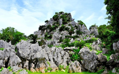
Daisekirinzan in Kunigami District, Okinawa Prefecture This video, "Oishi Forest Mountain|A walk in the sky" (大石林山 空中散歩), was created by "Okinawaworld." Daisekirinzan is a mountain in Okinawa's Kunigami District, about a 3-minute drive from Cape Hedo (辺戸岬, hedo-misaki), the northernmost point of the main island of Okinawa. As seen from 0:15 in the video, the island has a karst landscape created by limestone from 250 million years ago. The many strange rock formations and beautiful scenery is reminiscent of Guilin in China, known for its depictions in ink paintings. Nearby is Ashimui (安須杜), which has been a sacred place since ancient times. From Cape Hedo, the mountains seem steep and forbidding, but once you actually enter the mountains, you'll find a peaceful paradise of subtropical flora and fauna. Most of Daisekirinzan is designated as a specially protected area of Yanbaru National Park. You can enjoy the magnificent nature of Yanbaru while making your way through the two main trekking courses. The History of Daisekirinzan Photo:Daisekirinzan, Okinawa Daisekirinzan is a "quasi-national park" in Okinawa, in accordance with the Natural Parks Act. The park is managed with the aim of protecting the beauty of nature and contributing to the health, recuperation, and knowledge of Japanese citizens. On September 15, 2016, along with the official designation of Yanbaru National Park, a part of the area previously designated as Okinawa Kaigan Quasi-National Park was transferred to Yanbaru National Park. Daisekirinzan is a must-visit sightseeing area in Okinawa, even winning the "Tripadvisor Excellence Award 2018" on TripAdvisor for the fifth consecutive year. The Two Main Trekking Courses of Daisekirinzan Photo:Banyan Tree in Oishi Forest Mountain, Okinawa ① Strange Rock / Churaumi Panorama Course As seen from 0:36 in the video, this is a course where you can experience the tropical karst landscape at the northernmost tip of Okinawa. It takes about 60 minutes to complete the 1,200m course. You can see the strange rocks and massive boulders from 0:45 in the video. In addition to strange rocks and boulders, there are also many places of worship, such as the "Stone Forest Wall," which is said to be full of spiritual power. There is also an observation deck where you can enjoy a panoramic view, and during good weather conditions, you can even see Yoron Island (与論島, yoron-to) and Okinoerabu Island (沖永良部島, okinoerabu-jima) in Kagoshima Prefecture (鹿児島県, kagoshima-ken). There is also a barrier-free course, which is 600 meters long and takes about 20 minutes to complete It's designed for the elderly and people in wheelchairs to enjoy. As seen from 2:00 in the video, there's also Eboshi-iwa Rock (鳥帽子岩) towering into the sky, as well as the mysterious Nabe-ike Pond (鍋池). ② Yanbaru Forest Course The Yanbaru Forest Course can be seen from 2:09 in the video. Even in the midst of Daisekirinzan, this is an area where the subtropical trees grow especially densely. It takes about 30 minutes to traverse the 1,000m-long course, and you can enjoy the magnificent natural scenery, including the huge banyan tree seen from 2:32 in the video. Summary of Daisekirinzan Photo:The Phantom Flower Mucuna Macrocarpa, Okinawa In addition to the two famous trekking courses, there are many other sightseeing spots in Daisekirinzan. The Okinawa Stone Culture Museum (沖縄石の文化博物館, okinawa-ishi no bunka hakubutsukan) is a geological and ethnic museum centered around Okinawan stones. Gajumaru Road (ガジュマルロード), also known as the "Path of the Wind" (風の道, kaze no michi) is a road winding along gorgeous scenery. If you're lucky, you might even get the chance to see the rare "Mucuna Macrocarpa," which grows naturally in the mountains of Yanbaru. Even Okinawans rarely come across this "phantom flower." In recent years, Daisekirinzan has been attracting attention as the largest spiritual area in Okinawa. Consider adding Daisekirinzan to your itinerary when you visit Okinawa! 【Official Homepage】Yanbaru National Park Daisekirinzan https://www.sekirinzan.com/en/ 【Tripadvisor】Daisekirinzan https://www.tripadvisor.com/Attraction_Review-g1025649-d1373544-Reviews-Daisekirinzan-Kunigami_son_Kunigami_gun_Okinawa_Prefecture.html -
 Video article 3:47
The Caldera of Mt. Aso: A Magnificent Landscape Created by Nature. The Natural Wonderland, Full of Mysterious Scenery, Is Said to Have Been Created by the Gods!
Nature- 302 plays
- YouTube
The Caldera of Mt. Aso This PR video, titled "The Heritage of Tomorrow- God, Nature, and Man," is produced by “N.a” to promote Mt. Aso in Kumamoto Prefecture. The beautiful landscape of Kyushu, including Mt. Aso, can be seen throughout this video. Mt. Aso has a caldera produced by an ancient volcanic eruption, and the people have lived their lives here believing in the power of the gods and nature. A Caldera is a large circular depression in a volcano created from the body of the volcano collapsing. You can see a view of the caldera, billowing with volcanic smoke, in the video at 1:54. The Beautiful Scenery of Mt. Aso Photo:Aso Panorama Line Aso Shrine, known as the Ichinomiya of Higo province (肥後国 : Higono Kuni), and located at the foot of Mt. Aso, is a historic location, considered to be the number one shrine in Higo province. Its origins trace back to mountain and volcano worship in the Jomon period. Legend has it that the god of the shrine, Takeiwatatsumi no Mikoto, once kicked out water from the mountain in order to build a rice field around Mt. Aso. The area around Aso Caldera is designated as a Aso UNESCO Global Geopark. It's a beautiful location where you can learn about the natural landscape. At Aso UNESCO Global Geopark, focused on active caldera, you can see large clouds of smoke climbing high up into the sky. You can also enjoy a view of Aso Geopark in this video. Tourist Spots in the Mt. Aso Area! ©阿蘇市 Modifying Daikanbo (大観峰: Daikanbo) is the highest peak at Aso Kitagairin Zan (阿蘇北外輪山:Aso Kitagairin Zan) in Aso city阿蘇市 : Aso-shi). From the Daikanbo observantory, you can enjoy a spectacular view of the "Five Mountains of Aso" (阿蘇五岳: Aso Gogaku). The Aso Milk Road leading to Daikanbo is great for sightseeing. There's a parking lot and it can be easily accessed, so we definitely recommend checking it out if you have the chance. Some other hidden gems where you can explore the natural scenery of Mt. Aso include Shirakawa Suigen and Kusasenrigahama. Relax in the Hot Springs and Feel the Blessings of Nature! Photo:Kurokawa Hot Springs There are a lot of hot spring facilities around Mt. Aso due to the many volcanoes in the area. One that we recommend visiting is Kurokawa Hot Springs. We especially recommend Aso Farm Land, created with the idea of promoting health. You can enjoy delicious local cuisine and natural hot springs to heal your body after exploring Mt. Aso. Summary of Mt. Aso There are many sightseeing spots where you can experience the beautiful landscape of Mt. Aso. In the video, you can enjoy beautiful views of Mt. Aso with calm music playing in the background. Enjoy the mysterious scenery of Mt. Aso, famous as a land created by the gods. There are many volcanoes in Japan besides Mt. Aso. People have lived in reverence for them since ancient times. We hope to see you at Mt. Aso to enjoy the relaxing hot springs, beautiful scenery, and the spiritual shrines! 【Tripadvisor】Asosan (Takadake) https://www.tripadvisor.com/Attraction_Review-g298212-d320703-Reviews-Mt_Aso-Kumamoto_Prefecture_Kyushu.html -
Video article 2:38
Kujukushima in Nagasaki Has a Total of 208 Islands, and It Contains the Highest Density of Islands in Japan! Check Out the Superb View at the Tenkaiho Observatory!
Nature- 161 plays
- YouTube
Introducing Nagasaki Kujukushima Tenkaiho The video “Kujukushima Tenkaiho 8KHDR(Kujukushima Tenkaiho 九十九島 展海峰 8KHDR),” created by “Japan Explorers,” is a promotional video introducing the popular tourist spot “Kujukushima Tenkaiho,” part of the Saikai National Park in Sasebo, Nagasaki. Kujukushima is easily accessed from Sasebo station, (home to the popular tourist spot “Nagasaki Huis Ten Bosch”) taking only about 30 minutes to reach by car. It's an area of ocean 25 km north of Sasebo Port, dotted with islands. Many people visiting Kujukushima visit Nagasaki's Huis Ten Bosch and vice versa. The scenic view from the Tenkaiho observatory in Kujukushima, is introduced in the video with a famous Japanese song called “Jupiter.” Enjoy the contrast of the green islands and blue ocean as far as the eye can see. The Top 100 Landscapes of Japan - Kujukushima Photo:Tenkaiho rapeseed field Kujukushima is an archipelago located in the north of Nagasaki, 25 km from the west coast of the Kita-Matsuura Peninsula. It contains the highest density of islands in Japan. The word “Kujuku” means 99, but there are actually a total of 208 islands. There are only 4 inhibited islands, and they are: Kuroshima, Takashima, Maejima, and Toudomari. The rest are uninhabited. There are 4 observatories as well. Tenkaiho, Yumiharidake Observatory, Ishidake Observatory, and Kujukushima Hakkei. Tenkaiho is the one introduced in the video. From Tenkaiho, you can enjoy a panoramic view of Kujukushima which is included in the "100 Landscapes of Japan." The most popular view among photographers is of the cruise ship weaving through Kujukushima. It's also great for taking Instagram pictures, and many young adults come here to take photos. You can see the full view of Kujukushima from Tenkaiho in the video. Tenkaiho is also a popular spot for tourists who come to see the flowers. In the spring, rape blossoms are in full bloom and more than 150,000 cosmos bloom in the fall. There are also cherry blossoms and a night view as well. Sightseeing Around Kujukushima's Tenkaiho Photo:Scenery from Ishidake Observatory Among the observation decks, the most popular one for viewing the sunset is the Ishidake Observatory, where the silhouettes of islands floating in the sunset are as beautiful as an ink painting. You can also experience the view from the ocean by cruise ship or on a sailboat. The Kujukushima Pleasure Boat "Pearl Queen" is popular among tourists as you can see the southern islands of Kujukushima up close on a 50 minute cruise. While listening to the explanations of the legends and lore that remain on the island of Kujukushima, you begin to imagine its rocks turning into lions and turtles. On top of that, you can also experience the sunset cruise, where you can see the beautiful sun setting between the islands. There's also Kujukushima Aquarium Umikirara, and the Kujukushima Zoological and Botanical Garden Morikirara at Pearl Sea Resort. At 0:24 in the video, you can see the 2 ships floating in the distance. Sea kayaking, yachting, swimming and other marine sports that take advantage of Kujukushima Island's topography are also popular. From Sasebo Port, where Kujukushima is located, you can also take a ferry to enjoy sightseeing at the Goto Islands. Dining in Kujukushima Photo:Grilled oysters If you're going to Sasebo, you've got to try the Sasebo Burgers and fresh seafood. Kujukushima oysters are a famous winter food as well. In November and February, they hold the Kujukushima Oyster Festival. It's a fun event with 400 grills and endless oysters! Visitors can experience grilling their very own oysters too. Kujukushima rice crackers (from Kujukushima Group CO.,LTD.), Kujukushima Iriko Somen (a type of thin noodles), and Kujukushima puffer-fish, are some of the other popular foods in Kujukushima. A little-known souvenir spot on Kujuku Islands is "Kujukushima Namino Michi," a direct sales outlet on the westernmost tip of the Japanese mainland. It is a very small roadside station, but there are variety of fresh vegetables and sea food. It is a very small roadside station, but you can buy local vegetables and seafood here, as well as enjoy the local gourmet food of Kujukushima. Summary of Kujukushima With it's vast blue seas and incredible islands, it has to be one of the best natural landscapes in the world. The video shows some amazing views, so be sure to check it out if you still haven't yet. If you're looking for a vacation why not stop by Kujukushima? You definitely won't regret it. Sightseeing is also very convenient as there are several hotels around Kujukushima. There's also the Sasebo Convention & Visitors Association which is very useful for travelers. Gather your information beforehand and enjoy your trip to Kujukushima! 【Tripadvisor】Tenkaiho https://www.tripadvisor.com/Attraction_Review-g298217-d1820255-Reviews-Tenkaiho-Sasebo_Nagasaki_Prefecture_Kyushu.html -
Video article 3:18
Fujido Cave – This Mysterious 2.2 km Long Limestone Cave in Gunma Prefecture, the Largest in the Kanto Region, Will Take Your Breath Away! The Stalactites, Which Take 100 Years to Grow 1 Centimeter, Are a Famous Power Spot!
Nature- 164 plays
- YouTube
An Exciting Trip to the Largest Limestone Cave in Japan - Fujido Cave! This video, titled "The Largest Limestone Cave in Kanto!" (関東最大級の鍾乳洞 『不二洞』), shows a fabulous view of the Limestone cave located in Gunma. There are many mysterious limestone caves found throughout Japan. Of all the limestone caves, Fujido Cave, located in Kawawa Nature Park in Ueno-village, Tano District is the largest in the Kanto region, with an astonishing length of 2.2 km. Fujido is designated as a natural monument of Gunma Prefecture. If you explore inside of the Fujido, you're sure to have an extraordinary experience! You can see a number of breathtaking views in the video. Be sure to check it out to see the mysterious Fujido Cave! Fujido Cave Photo:Fujido Cave A limestone cave is a natural cave that is formed over a long period of time by the gradual erosion of limestone rock due to the inflow of underground water. It's said that the Ueno-village area, where Fujido Cave is located, was once covered with a deep virgin forest. Villagers in the area discovered the cave about 1,200 years ago, and since then, the cave has been used as a place for Buddhist training. In the Fujido Cave, the Fujido Yayoi Matsuri (festival) is held every March. Through the festival, people pray for the safety of the Fuji cave, the largest cave in the Kanto region. Highlights of Fujido Cave! Source :YouTube screenshot You can see the exploration of Fujido Cave at 0:38 in the video. At the end of a 120-meter underground tunnel, visitors climb up a 40-meter pit staircase to find a spacious limestone cave. The cave is kept cool throughout the year at a temperature of about 11 degrees Celsius(51.8°F). In the limestone cave, there are a lot of Instagram worthy spots made by nature such as the "Five Colored Clouds" (0:54), "Yama's Staff of Pilgrimage" (1:25), "Dragon King Falls" (1:44), and "Nyoraido" (2:02) and many more. There’s a legend about "Yama’s Staff of Pilgrimage" that says if you make a wish and touch it seven times, your wish will come true. Source :YouTube screenshot Inside of the cave, there are 45 spots named after Buddhist beliefs. At 2:17 in the video, you'll see a sparkling tower made of limestone. This tower, called "Renge-no-To" (Lotus Tower) is the largest stone in the cave. Next, at 2:34 you can see "Hi-no-Hashira" (The Pillar of Flame), and at 2:49 the sacred spot known as "Gohyaku-Rakan." It is said that it takes about 100 years for the limestone to grow 1 cm. Next time you visit Fujido, pay attention to the artistic shape of the cave and try to comprehend the amount of time it took to form. Summary of Fujido Cave, the Largest Cave in the Kanto Region Photo:Fujido Cave A limestone cave is a mysterious phenomenon created by nature. In recent years, the area around the Fujido Cave has become a popular power spot. Inside the cave you can also see the lit-up limestone, as shown in the video. Since the footing in the cave is not very good, we recommend that you wear comfortable clothes and shoes that are easy to get around in. If you're looking to travel to some of Japan's best-kept secrets, come to the mysterious Fujido Cave and experience the beauty of mother nature. Check out the video and feel for yourself the deep history and wonder concealed within the Fujido's limestone walls! ◆Fujido Cave◆ 【Address】665 Kawawa, Ueno-village, Tano Gun, Gunma Prefecture 【Access】35 minutes by car from Shimonita Interchange on the Joshinetsu Expressway 【Hours】9:00 AM - 4:30 PM ※ 9:00 AM 〜 4:00 PM in November, 10:00 AM〜 3:00 PM from December to mid March 【Closures】Open year round 【Average time spent here】About 40 minutes 【Parking】Available 【Telephone】 0274-59-3117 【Entrance fee】Adults 800 yen/Elementary and middle school students 500 yen (※ as of November 2019) -
Video article 11:19
Enjoy a Cup of Pure Bliss in the Great Outdoors! Enjoy an Out-of-the-Ordinary Experience With Coffee Brewed From the Spring Water of Oike Spring in Oita Prefecture
Nature- 29 plays
- YouTube
This video, titled "[Hiking] Coffee From a Spring - A Walk in the Woods and a Quiet Time" (【ハイキング】湧き水でコーヒー - 森林散策と静かな時間), was released by "Morinone Channel" (モリノネチャンネル). Wouldn't it be wonderful to make coffee from a clean spring in the mountains and take in the magnificent scenery? The Oike Spring Group in Yufu City, Oita Prefecture, introduced in the video, is an area at the source of the Aso River. The rainfall on Mt. Kurodake is filtered underground over a long period of time to produce clean spring water. It's very comfortable and cool even in summer as it is located 850 meters above sea level. Sitting under a tree, boiling water from the spring with a portable stove, and drinking coffee will refresh your body and mind. -
Video article 1:36
Viewer Discretion Advised! Mass Amounts of Pollen! Learn About the Causes, Symptoms and Treatments of Hay Fever, Which Affects Many People in Japan!
Nature- 780 plays
- YouTube
What Is Hay Fever? If you’re allergic to cedar pollen, just watching this video might cause you hay fever symptoms. The video, titled "スギ花粉の飛散 Cedar Pollen Dispersal ( Shot on RED EPIC High-speed )," is a super high-speed video that shows detailed footage of cedar pollen dispersing. It was created by "AQUA Geo Graphic." People with cedar pollen allergies show start to flare up just after watching some yellow cedar pollen be dispersed on TV commercials for anti-allergy medicine. It’s said that there are currently 25 million people with hay fever in Japan. The most common form of hay fever is cedar hay fever, but the number of people who suffer from other types of pollens, such as cypress, ragweed, and birch pollens, has been increasing rapidly, and countermeasures for hay fever are needed throughout the year. Treatment of Hay Fever Photo:A woman blowing her nose Is there any treatment for hay fever, which causes painful attacks every year when the pollen season arrives? In short, the only way to treat hay fever at its root is sublingual immunotherapy for cedar pollen allergies. In this treatment, a weakened cedar pollen pill is placed under the tongue and gradually taken into the body, in an attempt to get the patient’s body used to cedar pollen. The therapy takes more than 2 years and those who have severe hay fever attacks can have them during the treatment, so it’s not an effective cure for all, but it’s more than 60% likely to abate symptoms of cedar hay fever. For other types of pollen allergies, symptomatic treatment with medication or evacuation to pollen-free areas (Hokkaido and Okinawa) is necessary. Regarding anti-allergy drugs, the most effective ones are prescribed drugs, but over-the-counter drugs can be sufficiently effective as well if you act preemptively by using them before the pollen in the air is at its peak. The Causes of Hay Fever Photo:Cedar pollen Cedar pollen is called wind-borne pollen because it's dispersed by the wind. At the start of the video, you can see a large amount of pollen being dispersed by the wind on the branches of a cedar tree. According to the Ministry of Agriculture, Forestry and Fisheries, evergreen coniferous trees (cedar and cypress) are native to Japan, and their straight wood, which is not distorted, is suitable for use as lumber for wooden buildings, so large scale cedar plantations were established to revitalize the forestry industry after World War II, which led to major outbreaks of hay fever. The name "花粉症, kafunsho" ('hay fever' in Japanese), was first coined in October 1963, when the existence of allergic symptoms caused by cedar pollen was identified and presented at the annual meeting of the Japanese Society of Allergology in the fall of that year. The size of cedar pollen is just smaller than a heliozoan and can be seen with the naked eye using an optical microscope. Each cedar flower contains about 400,000 pieces of pollen, so during strong winds, large amounts are dispersed. When Do Hay Fever Symptoms Appear? Photo:Hay fever symptoms The Tokyo Metropolitan Government's Bureau of Public Health has been providing pollen information since 1985, and nowadays, the Japan Meteorological Agency and private meteorological forecasting services provide forecasts for the start of pollen dispersal and pollen distribution throughout the year. You can also check pollen forecasts for plants other than cedar, cypress, and ragweed on the Internet, so if you have hay fever, be sure to stay up to date. Even after December, when peak pollen dispersion has passed, early spring hay fever may come straight after the cold and flus of the year, so be sure to take countermeasures, such as keeping your room humid, ventilate and clean frequently, wash your hands, and gargle. Summary of Cedar Pollen and Hay Fever Cedar pollen allergies, which were once thought to be endemic in Japan, have spread, and are now common worldwide. Tomatoes can also worsen hay fever, so we recommend avoiding them during hay fever season! -
Video article 3:24
Chichibu's "Ashigakubo no Hyobashira" (Ice Pillars of Ashigakubo) is the highlight event of winter sightseeing in Chichibu, Saitama Prefecture! Watch the video to see the highlights!
Nature Travel Festivals & Events- 65 plays
- YouTube
The Ashigakubo Icicles: Video Introduction This video, titled "A Spectacular View [Ashigakubo Icicles] Light-up|A Top 3 Icicle Spot in Chichibu" (絶景「あしがくぼの氷柱」ライトアップ / 秩父三大氷柱2021), was uploaded by "Deep Channel / Shigeo Fukagawa" (Deepちゃんねる / 深川栄生). The Ashigakubo Icicles are generally open to the public from early January to late February in the town of Yokoze in Chichibu, Saitama, in Japan's Kanto Region, and are known as one of the top 3 icicle spots in Chichibu. At night on weekends, the icicles are lit up, attracting many tourists from all over Japan to see the fantastic sight of the icicles changing colors in the darkness. The icicles are just a 10-minute walk from Ashigakubo Station on the Seibu Railway line, making it an easily accessible spot for tourists to stop by. You can even take pictures of the icicles with the Seibu Chichibu Line train running nearby. Enjoy the realistic video of this beautiful icy world, which can only be viewed during the cold winter months in Japan. [Video] 0:51 - The Ashigakubo Icicles and the Nearby Train The Ashigakubo Icicles – How the Must-See Winter Attraction Is Created Photo:The Ashigakubo Icicles, Chichibu, Saitama The Top 3 Icicle Spots of Chichibu, which are normally visible from mid-January to mid-February, are a symbol of winter in Chichibu, a region known for its frigid temperatures. The three icicle spots are the Ashigakubo Icicles, the Misotsuchi Icicles, and the Onouchi Icicles. While the Misotsuchi Icicles are made up of natural icicles, the Onouchi Icicles and Ashigakubo Icicles are both man-made attractions. The magnificent icicles, which make good use of Chichibu's topography, are so impressive that it'is hard to believe that they're man made. The Ashigakubo Icicles are artificially created using sprinklers on the slope of the mountain. The giant field of icicles, standing 30 meters tall and 200 meters wide, covers the entire mountainside and is truly a sight to behold. The project was initiated by local residents of Yokoze and has become a popular tourist attraction since it was opened to the public in 2014. Because the Ashigakubo icicles are man-made rather than natural, it was possible to build a boardwalk where visitors can observe the icicles up close. This allows visitors to walk along the promenade and appreciate the various views of the icicles up close, as they change in height, angle, and color. The beautifully layered icicles are a work of ice art created through the cooperation of nature and man. Highlights & Attractions at the Ashigakubo Icicles Photo:The Ashigakubo Icicle illumination, Chichibu, Saitama The Ashigakubo Icicles are lit up both during the daytime as well as at night, making it a prominent midwinter event for sightseeing in Chichibu. The illumination lasts from sunset to 8 pm on Fridays, Saturdays, Sundays, and national holidays during the event period. Advance web reservations are required to view the illumination on Saturdays, Sundays, and national holidays. The Ashigakubo Icicle illumination slowly changes in color and intensity as it gets darker, adding to the fantastical atmosphere. The romantic view of the beautiful ice world is perfect for dates as well. We recommend enjoying the romantic view of the icicles while walking along the promenade, or from the top of the mountain overlooking the magical field of icicles. Another highlight of the event is the collaboration between the train and the icicles. If you're a photographer, or just looking to get a cool shot for Instagram, you can take an awesome photo of the train as it passes by the picturesque world of ice. [Video] 0:12 - The Ashigakubo Icicles Lit Up [Video] 0:51 - A Collaboration of the Train and Icicles Summary of the Ashigakubo Icicles Photo:Ashigakubo Station There are other places in Japan where large icicles can be seen in addition to the Ashigakubo Icicles, but they are not easy to visit due to long walks along steep paths. However, the Ashigakubo Icicles are the most accessible of the Top 3 Icicle Spots of Chichibu, and can be visited on a day trip from central Tokyo. The nearest station to the Ashigakubo Icicles is Ashigakubo Station on the Seibu Chichibu Line. It takes about 1.5 hours to reach Ashigakubo Station by train from Ikebukuro Station, and from there it's an approximately 10-minute walk. The Ashigakubo Icicles are a rare sightseeing spot where visitors can enjoy a spectacular winter view at just a train's ride from the heart of Tokyo. If you're in Japan this winter, consider visiting Chichibu for an extraordinary experience of ice and art. ◆Ice column with hollow legs◆ [Address] Daiji Ashigakubo, Yokose Town, Chichibu-Gun, Saitama Prefecture [Period] 16th to 25th February 2024 [Business Hours] Monday - Thursday 9:00-16:00 (last admission 16:00) [Friday, Saturday, Sunday and Holiday] Lighting up will be held from 17:00 to 20:00 Light-up varies depending on sunset time *Lighting up on Saturdays, Sundays and national holidays is by advance reservation (web) Day and night exchange system [Admission fee] 500 yen (over junior high school students) · 300 yen (elementary school students) [Transportation access] Seibu Chichibu Line Ashigakubo StationGet off and walk 10 minutes [Parking] Yes (free) Accept pets: Yes 【TripAdvisor】The Ashigakubo Icicles -
Video article 3:56
Lake Ozenuma Summer Hiking! Trek Through the Beautiful Daylilies of Lake Ozenuma, a Famous Place for Flowers at Oze National Park in Fukushima, Japan!
Nature Travel- 30 plays
- YouTube
The Daylilies of the Oe wetlands at Lake Ozenuma: Video Introduction This video, titled "Lake Ozenuma in Summer and Hiking Through the Daylilies of Oe Marsh|Daylilies at Lake Ozenuma|A Famous Place for Flowers" (夏の尾瀬沼とニッコウキスゲの大江湿原ハイキング 尾瀬沼のカンゾウ 花の名所 花見頃), was uploaded by "Discover Nippon." Daylilies are a common seasonal flower during summer in Japan, and Oe Marsh is famous for its spectacular view of the flowers. [Video] 0:21 - Oe Marsh The video shows the yellow daylilies swaying in the summer breeze and the beautiful scenery of various highland plants surrounding the marshland and Lake Ozenuma. Be sure to enjoy the beautiful video showing the lush greenery and brilliantly blooming flowers in this 4-minute video. [Video] 0:28 - Highland Plants [Video] 2:07 - Daylilies Oe Marsh – A Popular Attraction at Oze National Park Photo:Daylilies at Oe Marsh Oze National Park is a famous landmark in Japan and is home to Oe Marsh, an attraction known for its beautiful flowers. Oe Marsh lies around the Oe River near the village of Hinoemata, Fukushima and is known for the beautiful daylilies that bloom there. If you go down river, you'll find Lake Ozenuma, which is surrounded by a promenade for visitors to enjoy a relaxing stroll around it. It's an especially popular attraction during the summer months. What Are Daylilies? Facts and Interesting Information About the Famous Flower of Oze National Park Photo:Daylilies The daylilies of Oze National Park are characterized by their dark orange-yellow petals, of which it has six. The best time to see the daylilies at Oze National Park is from late June to August, as they grow at high elevations in the mountains, where temperatures can vary greatly. In Japanese, the daylilies at Oze National Park are called Nikkokisuge (ニッコウキスゲ, 'Nikko Daylilies'), which comes from the fact that there are many colonies of them that can be found growing in Nikko, Tochigi. Other than Oe Marsh, these daylilies can be found at Senjogahara Marshland and in the Kirifuri Highlands of Nikko, Tochigi, where the name originated, as well as in Nagano Prefecture, which is home to the Kirigamine Highlands and Kurumayama Highlands, where the flowers can be found growing in colonies. What makes the flowers so special is the vivid color of their petals. The flower is known to bloom in the morning and close in the evening, and it's almost as if it puts all of its energy into blooming to show you its brilliant beauty. Other Flowers to See at Oe Marsh, a Famous Spot for Flowers in Oze National Park! Photo:Daylilies at Oe Marsh Oe Marsh in Fukushima Prefecture is one of the most famous flower viewing spots in Oze National Park. Oe Marshland is famous for its flowers in summer, but there's a lot more to see than daylilies. Here we'll introduce the best time to view the different flowers around the Oe River from spring to summer, together with the meanings of each flower in Japanese culture. Daylilies A short-lived flower that blooms in the morning and withers in the evening. The bright color of the flower is its distinguishing feature. Best time to see it: Mid-July to late July Language of Flowers: Something new each day Photo:Skunk cabbage Skunk Cabbage At first glance, skunk cabbage looks like a large white flower, but the white part is actually not a petal, but rather a type of leaf called a bract. The white leaves have a strong presence, and the stick-like part of the leaf is surrounded by a flower that looks like an ear. It's popular for its dignified appearance. Best time to see it: Mid-May to early June Language of Flowers: Beautiful memories Photo:Cottongrass at Lake Ozenuma Hare's-Tail Cottongrass In June, small yellow petals bloom from this flower, and by the end of June, they turn into fluffy, white, round heads. The lovely cotton grass blooms all over Oze National Park. Best time to see it: Late June to mid-July Language of Flowers: Wavering thoughts ※The above information is based on the usual flower viewing times for Oze National Park as a whole. The blooming time and best time to see the flowers may vary with the climate of a given year and the altitude of the area the flower is growing, so please view this information only as a reference, not as a guarantee. Let's Go Hiking in Oze – Lake Ozenuma to Oe Marsh: A Walking Course Recommendation for Enjoying the Splendid Scenery of Oze National Park Photo:Lake Ozenuma hiking trails Oze National Park, which boasts a vast area, has a number of hiking courses, some of which are quite advanced and will require an overnight stay at a mountain lodge. We recommend a one-day course that begins at Numayama Pass on the Fukushima Prefecture side of the mountain, passes through Oe Marsh, and returns to Numayama Pass after stopping at Lake Ozenuma. It's a 4.35-mile hike, and the wooden boardwalk is well maintained, making it ideal for hiking beginners and those who want to enjoy a casual hike to see the views in Oze National Park. Oze National Park Day Trip Hiking Course Numayama Pass → Oe Marsh → Lake Ozenuma → Oe Marsh → Numayama Pass Near Lake Ozenuma, there is a famous photo spot as well as the Ozenuma Visitor Center where you can get information about the nature of Lake Ozenuma and Oze National Park by experts on the area. How to Get to Oze National Park From Tokyo How you decide to travel to Oze National Park will depend on which hiking course you plan on using. For the hiking course we listed above, the best way to reach Numayama Pass is as follows. Take the train from Tokyo Station to Aizukogen-Ozeguchi Station (210 mins), then take a bus to Numayama Pass (120 mins). This route will take about 6 hours in total and there will be a couple transfers depending on the line you use. Most trains will take you to Kitasenju Station and from there will be a straight shot to Aizukogen-Ozeguchi Station via the Tobu Line's Limited Express Revaty. Oze National Park From Tokyo Station Tokyo Station → Aizukogen-Ozeguchi Station → Numayama Pass ※The bus from Aizukogen-Ozeguchi Station to Numayama Pass is not in operation from November to March. ※Oike to Numayama Pass is closed from November to mid-May. If you're hiking at a trail starting at Hatomachi Pass or Oshimizu, you can use one of the two following routes. Take the shinkansen from Tokyo station to Jomo Kogen Station (60 mins), and from there take a bus to Togura (戸倉) (120 mins), and from Togura, take a bus to Hatomachi Pass (25 mins). Tokyo Station → Kogen Station → Togura → Hatomachi Pass ※The bus from Togura to Hatomachi Pass is not in operation from November to April. Take the shinkansen from Tokyo station to Jomo Kogen Station (60 mins), and from there take a bus to Togura (戸倉) (120 mins), and from Togura, take a bus to Oshimizu (20 mins). Tokyo Station → Kogen Station → Togura → Oshimizu ※The bus from Togura to Oshimizu is not in operation from November to April. Summary of Summer at Lake Ozenuma and Oe Marsh Currently, there are more than 900 species of alpine plants that inhabit Oze National Park, making it a very unique place to visit in Japan. In order to protect the scenery of Oze National Park, we ask that you please do not leave trash behind or step foot into the wetland area. In the summer, vast mountains and lovely flowers await you in Oze National Park. Whether you're a serious climber or visiting for a casual nature walk, be sure to stop visit! 【TripAdvisor】Oe Marsh -
Video article 2:07
The Mysterious Beauty of the Kakita River in Shizuoka, Japan! Video of the Kakita River Flowing With Melted Snow Water From Mt. Fuji!
Nature Travel- 126 plays
- YouTube
The Kakita River, a Unique Stream Flowing Through Shizuoka, Japan: Video Introduction This video, titled "Explore the Enchanting Crystal Waters of Kakita River with 8KVR!!!" (『静岡県清水町』が制作の『神秘の清流 柿田川 〜8KVRで体験!空中散歩と絶景癒しスポット〜) was uploaded by "Shimizu, Shizuoka" (静岡県清水町). The Kakita River is Japan's shortest Class 1 river, one of the three clearest rivers in Japan along with the Nagara River and the Shimanto River, and is fed by spring water from Mt. Fuji. In 1985, the Kakita River was selected as one of the "100 Famous Bodies of Waters" by the Kakita River Spring Group because of the purity of its water. Be sure to take a look at the beautiful 8K VR video of the clear stream created by the spring water from Mt. Fuji. The Kakita River, a Clear Stream Filled With Spring Water From Mt. Fuji! Photo:Spring water at Kakita River Park The Kakita River is a Class 1 river in the Kano River system located in Shimizu, Shizuoka, in Japan's Tokai Region. It boasts the largest volume of spring water in Japan, and most of the water in the Kakita River is spring water from melting snow and rainwater from Mt. Fuji that seeps into the Mishima lava flow. It is one of the most unique rivers in Japan. It is one of the three clearest rivers in Japan and is also designated as a Natural Monument by the government of Japan in the category of geological minerals. The Kakita River stays at a cool 15°C throughout the year, with a constant volume, allowing the Mishima Baikamo, an underwater plant unique to rivers, to grow in abundance, nurturing a rich natural environment that provides comfort to the local people. At one time, factories moved into the area to exploit the abundant spring water, and the deteriorating quality of the water made it uninhabitable for fish. However, thanks to the efforts of the local people to improve the water quality and protect the habitat for kingfishers and various fish, the Kakita River continues to flow as a clear and transparent stream. What Gives the Kakita River Its Blue Color? Photo:Spring water at Kakita River Park Kakita River Park is located upstream of the Kakita River. Originally the ruins of Izumigashira Castle built by Hojo Ujiyasu, a daimyo known as "The Lion of Sagami," this historic place is home to one of the most photogenic spots on the Kakita River. The "Wakima," is one of the sources of the Kakita River and can be seen from the observation deck of Kakita River Park. This place was originally used as a well by a nearby factory. The blue-colored source seen from the second observation deck is a mysterious beauty and has become quite popular on Japanese social media. The Kakita River spring water appears blue because of the water's ability to absorb red light. The deeper the water gets, the bluer it becomes. The color of the spring water changes slightly depending on the season, weather, and time of day, but the deepest and most beautiful blue can be seen in the mornings during the summer. Highlights of Kakita River Park Photo:Kifune Shrine at Kakita River Park, Shizuoka In addition to the Wakima, you can also enjoy a picnic at Kakita River Park! You can rent a picnic set at the Shimizu Town Tourist Information Center "Wakura Kakita River" and have a picnic without having to bring your own equipment. You can also rent equipment for activities such as badminton, dodgeball, and Othello/Reversi. Kakita River Park is located in the town of Shimizu in Sunto Ward, not Shimizu Ward, so be sure not to mix them up if you plan on visiting! Kifune Shrine, famous for boosting one's luck in love, is located in Kakita River Park. This shrine is a branch of Kibune Shrine in Kyoto and is dedicated to the god of water, but it has become known as a shrine for praying for love. On the approach to the shrine, there is a stone monument, and touching the stone shaped like a rice ball is said to bring good luck. There is also a mizu-mikuji (water fortune) that when placed in water makes the characters appear, making it a popular power spot for couples and those seeking love. Restaurants Near the Kakita River Photo:Tofu cuisine at Kitchen Kawasemi There are a variety of restaurants and cafes near the Kakita River. At the roadside stop Yusui no Michi (湧水の道), adjacent to Kakita River Park, you can find Kitchen Kawasemi (キッチンかわせみ) and Shokuji-dokoro Kawasemi Honkan (食事処かわせみ本館) where you can enjoy tofu dishes using fresh spring water from the Kakita River. At Kitchen Kawasemi, you can enjoy cold tofu and yuba (tofu skin) the freshest wasabi. Coffee brewed with spring water from the Kakita River is also available. Shokuji-dokoro Kawasemi Honkan offers a kominka (traditional Japanese home) experience, with reservations given priority. Here, the serve bento boxed lunches with a choice of either hot tofu or cold tofu made the famous spring water from the area. Also nearby is a store where you can purchase tofu ice cream, firm or soft tofu made spring water, green rice crackers, and coffee beans called Kakitagawa Yusui Blend (柿田川湧水ブレンド). Stop by after a stroll in Kakita River Park! A Brief Overview of Shimizu, Shizuoka Shizuoka Prefecture is the 10th largest prefecture in Japan based on population (3.5 million), and is located 1 hour from Tokyo and Nagoya via shinkansen (bullet train). Shimizu is a small town located in northeastern Shizuoka with a population of just 32,000. It's close to both the sea and mountains and even hot springs. Summary of the Mysteriously Clear Kakita River The Kakita River is one of the smallest rivers in Japan, at approximately 1.2 km long. However, it's so transparent that it is one of the three clearest rivers in Japan. The blue spring water gushing up from the earth, which can be seen from the second observatory in Kakita River Park, is a popular, photogenic spot. Kakita River Park is also a sightseeing spot where families can enjoy picnics and outdoor activities during the spring and fall. Nearby is Sun to Moon Kakitagawa, a large commercial facility that includes a movie theater and a shopping mall. When sightseeing in Shizuoka Prefecture, be sure to stop by Shimizu! 【TripAdvisor】Kakita River Park -
Video article 1:28
Sasaguri Kyudai Forest – Like Something You'd See in a Ghibli Movie! Discover One of the Most Scenic Spots in Fukuoka Prefecture, Plus Access Information and More!
Nature Travel- 125 plays
- YouTube
The Bald Cypresses of Sasaguri Kyudai Forest: Video Introduction This video, titled "Giant Conical Trees in a Pond "Bald Cypresses" in Sasaguri, Fukuoka" (view 池に浮かぶ円錐の巨木 福岡県篠栗町の「ラクウショウ」), was uploaded by "SankeiNews." Sasaguri Kyudai Forest is located at the western edge of the Kyushu University Forest in Sasaguri, Fukuoka, in Japan's Kyushu Region. Approximately 50 species of evergreen broad-leaved trees and 40 species of deciduous broad-leaved trees grow in this lush 42-acre forest. The mysterious beauty of the bald cypresses floating on the surface of the water in Sasaguri Kyudai Forest has become a hot topic in Japan, attracting a constant stream of visitors from all across the country. Please take a look at the video below to see the mystical view of Sasaguri Kyudai Forest created by the bald cypresses. [Video] 0:37 - Sasaguri Kyudai Forest An Introduction to Kyushu University Kyushu University, often abbreviated to "Kyudai," is a Japanese university in Fukuoka Prefecture. It is one of the top universities in Japan according to various sources, including the Times Higher Education Japan University Rankings, where it currently ranks 6th. While most courses at Kyushu University are taught in Japanese and will require a JLPT N1 certificate to qualify for, the university also teaches a number of courses in English, and accepts students with an IELTS score of 6.0 or greater. In order to study abroad at Kyushu University, you must be enrolled as a degree student at one of Kyushu University's partner institutions, and be nominated by your home university as a candidate. Kyushu University's graduate school programs have differing requirements in each department, but enrolling in graduate school at Kyushu University requires students pass an entrance exam that is regarded as one of the most difficult in Japan. What is Sasaguri Kyudai Forest? Photo:Sasaguri Kyudai Forest, Sasaguri, Fukuoka Sasaguri Kyudai Forest is located at the western edge of Kyushu University Forest in Sasaguri, Fukuoka, and is jointly managed and operated by Kyushu University and the town of Sasaguri. There is also a walking trail and the area has been open to the public since 2010. The vast 42-acre Sasaguri Kyudai Forest is home to about 50 species of evergreen broad-leaved trees, including itajii and Japanese blue oaks, and around 40 species of deciduous broad-leaved trees, including jolcham oaks and Japanese wax trees. The most eye-catching of all are the giant bald cypress trees. More than a dozen conical trunks can be seen standing in a corner of Kamata Pond. The bald cypress is characterized by its aerial roots. The aerial roots protruding from the ground supply oxygen to the submerged roots. In Japanese, the bald cypress is called "Rakusho" (ラクウショウ), but another name for the tree, which is native to North America, is "numasugi" meaning "swamp cedar." As this name suggests, it prefers places such as swamps and wetlands. The bald cypresses at Sasaguri Kyudai Forest were planted from seedlings in 1977 by Kyushu University to study the tree. The trees are currently around 20 meters tall, but can grow as tall as 40 meters in their natural habitat. The tree's appearance also changes with the seasons, with bright green leaves in the summer and autumn colors in the fall. There's a 2km-long promenade around Kamata Pond in the center of Sasaguri Kyudai Forest, which has been certified as a "forest therapy base" by the Forestry Agency of Japan for its pleasant atmosphere which is great for forest bathing. The Habitat and Characteristics of the Bald Cypress, and How It Differs From the Dawn Redwood Photo:Dawn redwoods The bald cypress is a deciduous coniferous tree of the cypress family (Cupressaceae) native to North America. The name bald cypress comes from their historical tendency to be among the first trees in the American South to lose their leaves in the fall. The bald cypress is characterized by its ability to grow in swampy areas, as evidenced by its other name, "numasugi" (ヌマスギ, lit "swamp cedar"). Another characteristic of the bald cypress, which grows very fast, is that when it becomes an old tree, it grows aerial roots that serve to supply oxygen to its submerged roots. The bald cypress is easily mistaken for the dawn redwood, which has a similar leaf shape, but the difference is obvious when looking at the way the leaves are attached. The bald cypress' leaves are attached to the branches in opposite directions, while the dawn redwood's leaves are attached to the same part of the branch in pairs. [Video] 0:42 - The Roots of the Bald Cypress The Waterfront Forest at Sasaguri Kyudai Forest + the Best Times to See the Bald Cypresses Photo:Bald cypresses at Sasaguri Kyudai Forest, Sasaguri, Fukuoka The 2km-long promenade around Kamata Pond at Sasaguri Kyudai Forest is dotted with attractions, including five plazas. Among them, the Waterfront Forest offers a mysterious view that makes you feel as if you have wandered into the world of Ghibli, and has become a popular spot on Japanese Instagram. This spectacular view can be seen when the water level of Kamata Pond is high. The best time to see the water level rise is from early spring to around the end of Japan's rainy season (June-mid-July). In contrast, the water level is low from summer to fall, but during this period, you can see the aerial roots of the bald cypresses. The best time to see the autumn leaves is mid-November, when the falling leaves decorate the area around the trees in place of the water. Sasaguri Kyudai Forest – Directions and Nearest Station Here is how to get to Sasaguri Kyudai Forest. If you go by train, the nearest station is Kadomatsu Station. Take the JR Fukuhoku Yutaka Line rapid train bound for Nogata at Hakata Station (platform 8), get off at Kadomatsu Station, and take a taxi to the Sasaguri Kyudai Forest south exit parking lot (篠栗九大の森南口駐車場, Sasaguri Kyudai no Mori Minami-guchi Chushajo), which takes about 10 minutes. The train ride from Hakata Station takes about 17 minutes, or 4 stops if you take the rapid train. The fare is 280 yen. If you take a bus, the nearest station is Kasuya Police Station. Take a highway bus bound for "Iizuka/Tagawa" from Tenjin Expressway BT bus stop #1 and get off at "Kasuya Keisatsu Sho-mae" (粕谷警察署前). Go straight for about 300m east on the sidewalk with the bus stop, turn left and keep going straight until you see the information board for "Sasaguri Kyudai Forest", follow the sign and you will arrive at Sasaguri Kyudai Forest in about 15 minutes on foot from "Kasuya Keisatsu Sho-mae". The bus ride from Tenjin to "Kasuya Keisatsu Sho-mae" takes about 35 minutes and costs 510 yen. If you're going by car, the shortest route to the waterfront forest is via the "North Exit Parking Lot." Directions are as follows: Exit the expressway at the "Fukuoka IC" and go straight for about 2 km in the direction of Iizuka (飯塚). Then turn left at the "Wadabashi Signal," go about 50m, turn left again, go straight for about 300m, then turn right and go uphill. Continue straight and you will arrive at the South Exit Parking Lot of Sasaguri Kyudai Forest. Go straight for about 200m from the South Exit Parking Lot, then turn right and walk about 300m through the forest to reach the North Exit Parking Lot. Although you can get there by car, we recommend using public transportation to avoid traffic congestion caused by the increase in the number of tourists to Sasaguri Kyudai Forest. Summary of the Bald Cypresess of Sasaguri Kyudai Forest Sasaguri Kyudai Forest is a photogenic spot that is rapidly gaining popularity. However, it's become so popular that many tourists visit the forest. As a result, the forest is experiencing problems, such as traffic congestion, and destruction of the forest due to violations of etiquette, such as barbecuing, littering, and taking photos in restricted areas. They've even considered closing the area to allow the forest to recover.... To prevent this from happening, please follow the rules and manners, and enjoy the cypresses of Sasaguri Kyudai Forest, one of the best healing spaces in Fukuoka. [TripAdvisor] Sasaguri Kyudai Forest -
Video article 6:52
Heisenji Hakusan Shrine – A Guide to the Famous Moss Temple of Fukui, Japan. Learn the History of the Temple, When to Visit, and More While Enjoying Video Footage of the Breathtaking Temple Grounds
Nature Travel Art & Architecture- 179 plays
- YouTube
Heisenji Hakusan Shrine in Fukui: Video Introduction This video, titled "【Fukui/Famous Tourist Attractions】Heisenji Hakusan Shrine - A Temple Covered in Moss - Heisenji Hakusan Shrine in FUKUI, JAPAN -" (【福井/観光名所】平泉寺白山神社/青苔が広がる苔の宮 - Heisenji Hakusan Jinja in FUKUI, JAPAN -), was uploaded by "channel WASABI." This video shows you the charms and history of Heisenji Hakusan Shrine with a video tour through its moss-covered cobblestone paths. Please enjoy the 7-minute video showing the solemn atmosphere of Heisenji Hakusan Shrine. Heisenji Hakusan Shrine: The History of the Shrine & the Deities Worshipped There Photo:Heisenji Hakusan Shrine, Katsuyama, Fukui Heisenji Hakusan Shrine is located in Katsuyama, Fukui, in Japan's Koshinetsu region. Its history dates back to 717 AD, during the Nara Period (710-794 AD). The shrine is the predecessor of Heisenji Temple and was founded by the monk Taicho Taishi. Later, it became a branch temple of Enryakuji Temple on Mt. Hieizan, and as the base of mountain worship in the Echizen Province, it boasted such prosperity that it had 48 shrines, 36 halls, and 6,000 monasteries. However, it was burned down during a civil rebellion in the Sengoku Period (1467-1615 AD). Moreover, Heisenji was banned during the Meiji Period as part of an order to separate Shintoism and Buddhism. Later, Hakusan Shrine was built on the site and became the current "Heisenji Hakusan Shrine." Located within the specially designated Hakusan National Park area, the site is a well-known tourist attraction in Fukui Prefecture, and is designated as a National Historic Site under "Former Precincts of Hakusan Heisenji Temple." Heisenji Hakusan Shrine is dedicated to the oldest goddess of well-being for couples, Izanami no Mikoto. In Japanese mythology, she is the creator of the Japanese continent and other gods in Japan and is considered the greatest god among them. It is believed that she blesses the well-being of couples, families, and future generations. In this vast area, many ruins have been discovered, though only a few have been studied. As researchers dig deeper, they discover more and more artifacts, such as cobbles and items from the schools of monks from medieval Japan. It's believed that there are still many more hidden treasures beneath the ground. The Best Seasons to Visit to See the Beautiful Mossy Temple Photo:Heisenji Hakusan Shrine, Katsuyama, Fukui Heisenji Hakusan Shrine is famous as a moss temple. From the cedar grove, to the boundary stones along the approach to the shrine, to the stone pavement leading to the hall of worship, the spacious shrine grounds are covered in beautiful green moss. The best time to view the approximately 100 varieties of moss is during Japan's rainy season from June to July. During this season, when the mosses are even more beautiful, it can feel as if you've wandered into another world. Spring brings fresh greenery, while in early summer the heavenly water-laden mosses shine even brighter. Autumn brings colorful foliage, and winter brings snowy landscapes. The contrast of the four seasons at Heisenji Hakusan Shrine is so incredible that it's hard to believe such beauty was created by nature. Heisenji Hakusan Shrine is the northern center of worship for Mt. Hakusan and is a popular power spot. If someone is available at the shrine office, have a goshuin stamp put directly into your stamp book if you're collecting them. Beautiful Echizen washi (Japanese paper) is used for the goshuin stamps. Attractions at Heisenji Hakusan Shrine Photo:Heisenji Hakusan Shrine, Katsuyama, Fukui There is much more to see at Heisenji Hakusan Shrine than just moss, and while the time required for a visit varies depending on how you choose to tour the grounds, it generally takes between 30 minutes and 2 hours. You can request a guide up to 7 days in advance, so you can plan your visit in accordance with your travel itinerary. Here are some of the highlights of the shrine. The Cobblestone Paths Leading to the Garden The cobblestone paths at Heisenji Hakusan Shrine are included in the list of Top 100 Roads in Japan. It's said that about 1,000 years ago, ascetic monks carried stones from the Kuzuryu River to make them. [Video] 0:30 - The Cobblestone Path Leading to the First Torii Gate The Second Torii Gate The second torii gate of Heisenji Hakusan Shrine has quietly watched years of history unfold before its eyes, with visitors such as Minamoto no Yoshinaka praying for victory in battle, or Minamoto no Yoshitsune and Benkei passing through the gates. The second torii gate also has an unusual shape with a roof over it. Mitarashi Pond This spring was discovered by the great Buddhist monk Taicho Daishi on his way to Mt. Hakusan. Legend says that a goddess appeared before him and instructed him to ascend to Mt Hakusan. [Video] 1:48 - Mitarashi Pond Surrounded by Dense Greenery The Giant Cedar of Wakamiya Hachiman Near Wakamiya Hachiman is a massive, majestic 450-year-old cedar tree. It is one of the seven cedars that survived the burning of Heisenji Hakusan Shrine during the Sengoku Period. The Main Shrine Pavilion of Heisenji Hakusan Shrine In 1795 AD during the Edo Period (1603-1868), Shigetomi Matsudaira, the samurai in charge of the Echizen province (today known as northern Fukui Prefecture), rebuilt the main pavilion of Heisenji Hakusan Shrine. The door of this shrine opens only once every 33 years, and the next time the door is scheduled to open is in 2025. On the door, there are spectacular sculptures of mythical creatures, including Kirin and Dragons. The best way to get to Heisenji Hakusan Shrine is by car. It has a parking lot that can accommodate 30 standard vehicles and it costs 300 yen to park, in order to fund maintenance of the historical landmark. Things to Do Near Heisenji Hakusan Shrine Heisenji Hakusan Shrine is located a short distance from the city of Katsuyama, where there are a number of things to see and do. Below we'll introduce a few of them. Echizen Daibutsu A 17-meter-tall Buddha statue. Taller than the Great Buddha of Nara at Todaiji Temple, it features 2 smaller Buddhist statues on each side of it, and Seidaiji Temple, where the Echizen Daibutsu is located, houses 1,281 Buddha statues. The temple is also home to a 5-story pagoda. Hours: 8:00 am - 5:00 pm (9:00 am - 4:00 pm during winter) Admission Fee: Adults: 500 yen, Elementary, middle, and high school students: 300 yen. Discounts are available for groups of 15 or more. Katsuyama Castle Museum Katsuyama Castle was built during the Warring States Period (1467-1615 AD) in present-day Katsuyama, Fukui. During the Edo period (1603-1867), it was used as the headquarters of the Katsuyama Clan. The castle museum features swords, guns, armor, etc., with hundreds of years of history to explore. Hours: 9:30 am - 4:30 pm (Admission until 4:00 pm). Closed on Wednesdays Admission Fee: Adults: 700 yen, Children (Elementary, middle, and high school students): 280 yen. Discounts available for groups of 20 or more. Yume Ole Katsuyama Textile Factory Memorial Hall Once a textile factory, the building was repurposed into a museum and now acts as a place where visitors can learn about spinning and weaving machines and techniques used in the past. There are also hands-on experiences available where visitors can make their own coasters, etc. from silkworm cocoons. Hours: 9 :00 am - 5:00 pm. Closed on Wednesdays (If Wednesday is a holiday, closed the following day). Admission Fee: General admission: Free. Hand weaving coaster experience: 600 yen. Hand-woven hemp yarn coaster experience: 800 yen. Mayu dama (cocoon ball) craft experience: 600 yen. High loom weaving experience: 1,500 yen Fukui Prefectural Dinosaur Museum As one of the leading dinosaur museums in the world, the Fukui Prefectural Dinosaur Museum is filled with a variety of dinosaur skeletons and fossils of plants and animals, and also features animatronic robots showing how the dinosaurs would have moved. Hours: 9:00 am - 5:00 pm (Admission until 4:30 pm) Admission Fee: Adults: 730 yen, High school and college students: 420 yen, Elementary school and middle school students: 260 yen, Young children and seniors: Free. Discounts are available for groups of 30 or more. Summary of Heisenji Hakusan Shrine The dense trees, carpets of moss, and cobblestone approaches steeped in history make Heisenji Hakusan Shrine a one-of-a-kind tourist attraction. Enjoy a trip to the mystical shrine and experience the slow flow of time. There are many nearby tourist attractions in the surrounding area to check out as well. Stay at a hotel and enjoy the charms of Fukui to your heart's content! 【TripAdvisor】Heisenji Hakusan Shrine -
Video article 5:38
Savor the Beauty of Nature at "Japan Alps Kamikochi" in Japan's Scenic Shinshu Region! Enjoy a Relaxing Time Surrounded by Greenery and Negative Ions!
Nature- 62 plays
- YouTube
Sightseeing in the Japanese Alps in Kamikochi This video, titled "LEAP | Kamikochi (上高地) - Japan - UHD 4K," was released by Jonathan Teo. It shows an aerial view of Kamikochi, a tourist resort area overflowing with natural beauty in Nagano Prefecture. Kamikochi, located in Matsumoto City in western Shinshu, is a scenic, mountainous area situated at an elevation of approximately 1,500 meters above sea level. The entire area makes up Chubu Sangaku National Park (中部山岳国立公園), and is a base for climbing the Hotaka Mountain Range (穂高連峰) and Mt. Yari (槍ヶ岳). If you want to enjoy the beautiful scenery, plan a trip to Kamikochi and explore the mountain route! Recommended Sightseeing Spots in Kamikochi Photo:Kamikochi, Nagano Prefecture After the opening of the mountain, many tourists flock to Kamikochi, which has a series of peaks that are coveted by alpinists, for the purpose of mountain climbing. When climbing in Kamikochi, be sure to get your fill of the unique mountain scenery. Kappa Bridge (河童橋), the symbol of Kamikochi, is a popular spot where you can enjoy a great view. Be sure to also check out Taisho Pond, Myojin Pond, and Tashiro Pond, which are known for their natural beauty. At 0:53 in the video, you can see the Azusa River glowing a cobalt blue. Key Points to Remember When Visiting Kamikochi Photo:Kamikochi, Nagano Prefecture Kamikochi is a fun mountain for both beginners and advanced climbers. If you're looking for a casual hike, consider planning a day trip. The climate in the mountains can change easily, so be sure to suitable clothing when climbing in the Kamikochi area. Also, be sure to bring maps, drinks, and emergency food in your luggage just in case. Inns and Souvenir Shops at Kamikochi in Shinshu, Nagano Photo:A hot spring at an inn There are a number of hot spring inns and tourist hotels in the area around Kamikochi. After a day of hiking, we recommend staying at an accommodation with a hot spring to relax and rejuvenate. There are also many tourist attractions nearby, including restaurants serving local gourmet food and souvenir shops. Summary of Kamikochi, Located in Shinshu, Nagano Photo:The scenery of Kamikochi, Nagano Prefecture There are many scenic spots like the ones shown in this article's video, in Kamikochi. Walking around while enjoying the unique mountain scenery is sure to leave you feeling refreshed. To protect the environment around Kamikochi, personal vehicles are prohibited in and around the area. Park your car at the parking lot in Sawatari before Kamikochi and use the shuttle bus to get there. 【Official Website】Kamikochi Official Website|Area Introduction https://www.kamikochi.or.jp/learn/spots 【Tripadvisor】Kamikochi https://www.tripadvisor.com/Tourism-g12830931-Kamikochi_Matsumoto_Nagano_Prefecture_Koshinetsu_Chubu-Vacations.html -
Video article 3:25
Tashirotai Marsh – Fantastical Cottongrass and Breathtaking Views of the Milky Way in Aomori Prefecture! Explore the Oldest Marshland in the Hakkoda Mountain Range!
Nature Travel- 55 plays
- YouTube
Tashirotai Marsh: Video Introduction This video, titled "Time Lapse #129|Mt. Hakkoda|Tashirotai Marsh|A Marsh of Rhododendrons and Cottongrass|4K" (Time Lapse #129 Mt.Hakkoda Tashirotai ツツジとワタスゲの湿原 八甲田・田代平 4K), was uploaded by "aomorigonta." Tashirotai Marsh is a high-elevation marsh located in Aomori City, Aomori Prefecture, in Japan's Tohoku region. The video shows the beautifully blooming cottongrass and azaleas in early summer, as well as the beautiful Milky Way in the night sky, and other breathtaking views that are sure to captivate. Be sure to check it out before reading along. Tashirotai Marsh – Discover the Beautiful, Natural Scenery of Aomori, Japan Photo:Ryujin-numa at Tashirotai Onsen Tashirotai Marsh is located at the northern end of Towada-Hachimantai National Park in Aomori City, Aomori Prefecture, and is a high-elevation marsh designated as a Natural Monument. Tashirotai Marsh was formed from a caldera lake that was created by volcanic activity in the Hakkoda Mountain Range approximately 2 million years ago, and is located at a relatively low elevation at 560 meters above sea level. Furthermore, Tashirotai Marsh is the largest and oldest of all the marshlands in the Hakkoda mountain range. Ryujin-numa (Ryujin Marsh), located at the entrance to Tashirotai Marsh, is filled with emerald green water, and its mysterious scenery has made it a popular spot among both tourists and the people of Aomori Prefecture. Tashirotai Marsh – Autumn Leaves & Other Seasonal Views Photo:Rhododendrons in the Hakkoda Mountains, Aomori A variety of alpine plants can be seen in Tashirotai Marsh, and from June to July, cottongrass and azaleas bloom, providing beautiful scenery. In summer, zenteika and eleorchis bloom, and the yellow flowers of kinkoka are especially popular. The yellow flowers bloom all over the area and are a must-see, especially if you're a photographer or instagrammer. From late September to mid-October, it's a popular spot for tourists to view the colorful autumn leaves, and the entire marshland changes to a golden hue, fascinating visitors. Tashirotai Marsh has a 1,600-meter-long walking trail that takes about one hour to complete. Visitors can enjoy the beautiful nature and fresh air in the summer and fall. The Tashirotai Marshland Course – Journey Through Nature in the Hakkoda Mountains Photo:Autumn leaves at Tashirotai Onsen, Hakkoda Mountains The Tashirotai Marshland Course is a recommended way to enjoy the nature of the Hakkoda Mountain Range, and starts from Aomori City. Driving along the driving route through the foot of the majestic Hakkoda Mountains, visitors can enjoy viewing the marshlands scattered throughout the Hakkoda Mountain Range. During the summer, visitors can enjoy the blooming flowers and the greenery of the Hakkoda Mountain Range, and in the fall, the autumn leaves add color and beauty to the natural scenery. It's a course we definitely recommend trying if you have the chance. The highlight of the Tashirotai Marshland Course is the natural beauty of the marshland, which changes with the seasons. Tashirotai Marsh is a diverse wetland with a variety of aquatic plants and offers a wide range of natural attractions, from alpine flora to the mysterious marshes created by the melting snow of the Hakkoda Mountains. There are also a number of delicious restaurants and footbaths along the driving route. The course is 88.2 km long and takes 3 hours and 38 minutes to complete. We urge you to visit Aomori and take your time to enjoy the seasonal natural beauty of the Hakkoda Mountains. Summary of Tashirotai Marsh Around Tashirotai Marsh, you'll find Hakkoda Onsen, where you can relax in hot springs after a long day of hiking/walking. There's also lodging facilities, such as the Hakkoda Hotel, so if you like the outdoors, consider planning a trip to enjoy the natural beauty of the Hakkoda Mountain Range. Before visiting, you can also check live cameras that provide video of Aomori Prefecture Route 40 (青森県道40号線, Aomori Kendo Yon-juu Go-sen) to see the weather and traffic conditions. Parking is available for those coming by car. When sightseeing in Aomori, consider stopping by Tashirotai Marsh to experience the natural attractions of the Hakkoda Mountain Range. 【TripAdvisor】Tashirotai Marsh https://www.tripadvisor.com/Attraction_Review-g298241-d1721841-Reviews-Tashirotai_Wetland-Aomori_Aomori_Prefecture_Tohoku.html -
Video article 24:24
Rock Climbing on Mt. Oku-Hotaka! The Breathtaking View From the Peak of the Mountain in Nagano and Gifu Prefectures Will Change How You View the World!
Nature- 172 plays
- YouTube
Climbing Round Trip From Mt. Oku-Hotaka to Uma no Se: Video Introduction This video, titled "Mt. Oku-Hotaka to Gendarmes|Route Change After a Rockslide|Video of a Detailed Round Trip of Uma no Se" (奥穂高からジャンダルム 滑落みて馬の背ピストンへ変更 馬の背詳細往復動画), was uploaded by "Biryu Jr." Mt. Oku-Hotaka Photo:The Hotaka mountain range from Mt. Norikura Mt. Oku-Hotaka is the main mountain of the Hotaka Mountain Range, which straddles Nagano and Gifu prefectures in the Hida Mountain Range of Chubu-Sangaku National Park in the southern part of Japan's Northern Alps. At 3,190 meters above sea level, it is the highest peak in the Northern Alps and the third highest in Japan after Mt. Fuji and Mt. Kita. Mt. Oku-Hotaka (奥穂高岳), Mt. Karasawa (涸沢岳), Kita-Hotaka (北穂高岳), Mae-Hotaka (前穂高岳), Nishi-Hotaka (西穂高岳), and Mt. Myojin (明神岳), are collectively referred to as Mt. Hotaka. It is said that the origin of the mountain's name comes from a legend that a god named Hotakami-no-Mikoto descended to the summit of Mt. Oku-Hotaka. Even today, the mountain is revered as a sacred mountain by local people, who visit and climb it to pray. The first person to summit Mt. Oku-Hotaka was surveyor Gunji Abe in 1906. With its challenging routes, powerful rocky ridges, and panoramic views from the ridge, Mt. Hotaka continues to attract many climbers to this day. The Geological Features of Mt. Oku-Hotaka Here, we'll take a look at the geological features of Mt. Oku-Hotaka ・Volcanic Terrain Mt. Hotaka, including Mt. Oku-Hotaka, is formed mainly of dacitic ignimbrite called "Hotaka andesite." This rock was formed by pyroclastic flows during an eruption approximately 1.75 million years ago, and was uplifted 2,000m over a period of 1 million years after a large-scale eruption. ・Glacial Landforms Many glacial landforms have been observed on Mount Hotaka. Glacial landforms are landforms created by glaciers that have accumulated soil, sand, rocks, etc., while carving away the land below. Mt. Oku-Hotaka – Uma no Se Photo:Uma no Se on Mt. Oku-Hotaka Mt. Okuhotaka, a famous mountain climbing spot, has a narrow ridge called "Uma no Se" (horse's back), which is steep and features cliffs on both sides. Because of how steep it is, it's also a dangerous place where falling accidents occur frequently. The slopes, which look like a combination of rubble, require extreme caution in order to prevent accidents. In the video, you can see how they decide not go to Gendarme (a rocky summit between Mt. Oku-Hotaka and Mt. Nishi-Hotaka), and instead decide to descend via Uma no Se. It's as realistic as if you were there yourself. The sound of the wind, the hands gripping the rocks, the shadows of climbers moving toward the spectacular views... the power of these scenes draws you in. [Video] 5:44 - Advancing Along Uma no Se Mt. Oku-Hotaka – Routes and Difficulties Here are the routes of Mt. Oku-Hotaka according to difficulty level: ・Kamikochi Course (上高地コース) - The recommended route for beginners Starting from Kamikochi Bus Center, the most common route is [Myojin (明神) - Tokusawa (徳沢) - Yoko (横尾) - Hontanibashi (本谷橋) - Karasawa (涸沢) - Mt. Hotaka Hut (穂高岳山荘, Hotakadake Sanso), Mt. Oku-Hotaka]. Your itinerary should be arranged according to your physical fitness. It is common to stay overnight during the climb. ・Kenkyakusha-Muke Course (健脚者向けコース) The rough route is [Shin Hotaka Onsen (新穂高温泉) - Shirade Hut Ruins (白出小屋跡) - Mt. Hotaka Hut (穂高岳山荘), Mt. Oku-Hotaka]. The trailhead is at Shin Hotaka Onsen. Since there are some points on the ascent where it's easy to make a mistake on the route, it's recommended that you be accompanied by an experienced climber. Furthermore, since route conditions change according to lingering snowfall, it's necessary to check trail conditions ahead of time. ・Advanced Climbing Course (熟練・上級者向けコース) The rough route is [Kamikochi Bus Terminal (上高地バスターミナル) - Yoko (横尾) - Yarisawa Lodge (槍沢ロッジ) - Kakusei Hutte (殺生ヒュッテ) - Yarigatake Hut (槍ヶ岳山荘) - Minamidake Hut (南岳小屋) - Kitahotaka Hut - Mt. Kitahotaka Hut (北穂高小屋) - Karasawa Hut (涸沢岳) - Mt. Hotaka Hut (穂高岳山荘)]. The ridge course from Yarigatake continues through rocky terrain with considerable height differences. Normally, three nights are required for this route, and extreme caution is needed as there are many steep sections. Summary of Mt. Oku-Hotaka Photo:Mt. Oku-Hotaka In this article. we introduced one of the three tallest peaks in Japan, Mt. Oku-Hotaka, and Uma no Se. Although there are dangers, such as slips and falling rocks, Mt. Oku-Hotaka is a thrilling mountaineering experience that features spectacular views of nature that attracts many climbers. Although the climb is not without its dangers, the view from the summit and the thrill of climbing over Uma no Se is said to be exceptional. If you wish to take on this challenge, please do your research and go fully prepared. That being said, if you're just here to enjoy some of the views, hopefully the video is enough for you. 【TripAdvisor】Mt. Oku-Hotaka https://www.tripadvisor.com/Attraction_Review-g298102-d7242442-Reviews-Mt_Okuhotaka-Chubu.html -
Video article 3:11
Experience the Beauty of Kikuchi Valley! Enjoy Clear Streams in the Nature of Kumamoto!
Nature Travel- 281 plays
- YouTube
Kikuchi Valley Video Introduction This video, titled "[4K UHD] Kikuchi Valley in Summer (Kikuchi, Kumamoto)" ([ 4K UHD ] 夏の菊池渓谷(熊本県菊池市)Kikuchi Valley in Summer), was uploaded by "AQUA Geo Graphic." Kikuchi Valley is a nature-rich valley located at the source of the Kikuchi River in Kumamoto Prefecture, and is widely known as a spot where visitors can enjoy its spectacular seasonal scenery. It is also a popular tourist spot for people of all ages, as visitors can enjoy various activities such as kayaking. Check out the beautiful images of Kikuchi Valley. Kikuchi Valley - One of the Most Beautiful Valleys in Kumamoto Photo:Aso-Kuju National Park Kikuchi Valley is known as a "forest of relaxation" stretching from Kikuchi to Aso in Kumamoto Prefecture. The Kikuchi Valley area is covered with primeval forests of firs and zelkova trees, and has been designated as a special recreation area in Aso-Kuju National Park. In addition, the Kikuchi Riverhead has been selected as one of the Top 100 Water Sources in Japan. Kikuchi Valley has many attractions, and waterfalls of various sizes. Reimei Falls around Ryugabuchi, Tengu Falls, and Yonjusanman Falls, selected as one of the Top 100 Waterfalls in Japan, are popular tourist attractions. In addition, Kikuchi Valley is so rich in nature that it has been selected as one of the Top 100 Forests for Forest Bathing and the Top 100 Nature Spots in Kumamoto because of the natural environment. Therefore, visitors are required to pay a maintenance fee to preserve the environment. From Cherry Blossoms to Autumn Leaves – Seasonal Highlights of Kikuchi Valley Photo:Autumn leaves in Kikuchi Valley Kikuchi Valley is known as a summer resort and is a place to cool off naturally. One of the highlights of the valley is that it is comfortable even in the hot Japanese summer, and visitors can enjoy a pleasant stroll in the great outdoors. There are two walking courses: a 1-km round-trip "Healing Course" and a 2-km round-trip "Negative Ion Enjoyment Course." The courses allow visitors to naturally detox their minds while enjoying the surrounding scenery. In spring, visitors can enjoy cherry blossoms at the Kikuchi Valley Rest Plaza, in fall, the autumn leaves begin to change color around the end of October, and in winter, the misty ice flowers bloom. Kikuchi Valley, with its beautiful and spectacular scenery throughout Japan's four seasons, offers plenty to see! The photogenic scenery is popular among photographers, instagrammers, and young people alike. Mizunoeki Pleasure Park - An Exciting Park for Families You might be worried that small children won't be able to have fun in a place with so much nature. For families, we recommend Mizunoeki Pleasure Park, located near the Kikuchi River flowing from Kikuchi Valley. Here, visitors can enjoy a variety of athletic activities, including BMX, and bouldering, and even go fishing in the fishing pond. After playing at Mizunoeki Pleasure Park, don't forget to take in the beautiful nature of Kikuchi Valley. Summary of Kikuchi Valley in Kumamoto, Japan Did you watch the video of Kikuchi Valley in summer, with its beautiful scenery and the soothing sound of flowing water? Camping and barbecues are prohibited in Kikuchi Valley in order to preserve the natural environment. Those who wish to enjoy playing in the river, camping, or barbecuing should use facilities such as Mizunoeki Pleasure Park or Mizunoeki Campground (水の駅キャンプ場). At Mizunoeki Pleasure Park, you can enjoy fishing for rainbow trout and salmon in the fishing pond, and you can even cook and eat them on-site. In the vicinity of Kikuchi Valley, there are facilities where you can enjoy a day trip to a hot spring, a visitor center where you can have lunch and refreshments, and two parking lots for sightseeing. Kikuchi Valley is close to Mt. Aso, and visitors can enjoy the spectacular view from the outer rim of the mountain. When sightseeing in Kumamoto, consider stopping by Kikuchi Valley, a place where you can experience Japan's great outdoors. In today's stressful society, it's important to get away from everyday life and detoxify your mind. And the natural scenery of Kikuchi Valley allows you to do just that. 【TripAdvisor】Kikuchi Valley https://www.tripadvisor.com/Attraction_Review-g1023370-d1238998-Reviews-Kikuchi_Gorge-Kikuchi_Kumamoto_Prefecture_Kyushu.html -
Video article 1:30
The Beautiful Shiroyone Senmaida Rice Terraces Descending Into the Sea of Japan! The Rice Paddies of Noto Peninsula Are One of the Best Examples of Okunoto Coast's Scenic Beauty! Come Check Out the Terraces, Designated a National “Place of Scenic Beauty”!
Nature Travel- 262 plays
- YouTube
Introduction to Ishikawa Prefecture’s Beautiful Shiroyone Senmaida Rice Terraces This video, “Ishikawa Shiroyone Senmaida - 白米千枚田 - 4K Ultra HD”, was created by “TokyoStreetView - Japan The Beautiful.” It shows the exquisite view of the Shiroyone Senmaida Rice Terraces dyed in brilliant shades of green. The rice terraces are located in Wajima City (輪島市, Wajima-shi), of Ishikawa Prefecture. The Shiroyone Senmaida Rice Terraces are located in Shiroyone, Wajima City, Ishikawa Prefecture in the Hokuriku region (北陸地方, Hokuriku chiho) of Japan. The view of the rice terraces changes with the seasons, making it a popular sightseeing area. In this article, we'll introduce the history and appeal of the Shiroyone Senmaida Rice Terraces, as well as information for visitors. The rice terraces are considered the epitome of Japanese agriculture, as well as the definitive landscape of Japan. Enjoy exploring the rice terraces shown in the article. Be sure to follow along with the video as well! The Shiroyone Senmaida Rice Terraces Photo:Ishikawa Shiroyone Senmaida The Shiroyone Senmaida Rice Terraces can be found on Noto Peninsula in Ishikawa Prefecture. The rice terraces are said to have been created nearly 400 years ago. There are around 1,004 paddy fields arranged on the steep slopes, each about 20 squares meters in size and in a variety of shapes. The view of the rice terraces descending into the Sea of Japan can be seen at 0:05 in the video. The Shiroyane Senmaida Rice Terraces are designated not only as a national "Place of Scenic Beauty," but also as one of "Japan's Top 100 Terraced Rice Paddies." In addition, the rice terraces are also a "Globally Important Agricultural Heritage System," known as "Noto's Satoyama and Satoumi." As farming machinery is too large for the paddy fields, the traditional hand-farming method "Nawashiroda" (苗代田) is used. The paddy fields all belong to certain owners who are in charge of their maintenance. Every year, the Shiroyone Senmaida Planting and Harvesting Event is held, with the owners and volunteers working together to plant and harvest rice by hand. Photo:Ishikawa Shiroyone Senmaida As you can see in the video, you can enjoy the summer view of the refreshingly green rice terraces. However, the rice terraces change with the seasons, making it a gorgeous view all throughout the year. In the spring, water soaks the paddy fields for rice planting, causing the terraces to sparkle and reflect the blue sky. In autumn, the rice has grown and the terraces turn a beautiful golden-yellow. During the peak rice-harvesting season, there are even wedding ceremonies held at the rice terraces. In winter, the sight of snow covering the rice terraces is absolutely beautiful, and you can also enjoy the illumination along Aze Street, "Aze no Kirameki" (あぜのきらめき, Aze-no-kirameki). The official mascot "Senren-chan" occasionally participates in events as well. The Shiroyone Senmaida Rice Terraces can be accessed through public transport. The rice terraces are a 5-minute walk from the Shiroyone Senmaida bus station, which is 2 and a half hours by bus from Kanazawa station (金沢駅, Kanazawa-eki) in Ishikawa Prefecture. For visitors travelling by personal or rental car, there is a parking area available at the roadside station "Senmaida Pocket Park." The address is- Ishikawa Prefecture, Wajima City, Shiroyanecho 99-5 (石川県輪島市白米町99-5, Ishikawa-ken Wajima-shi Shiroyane-cho 99-5). Summary of Ishikawa Prefecture’s Shiroyone Senmaida Rice Terraces Photo:Aze no Kirameki illumination In this video, “Ishikawa Shiroyone Senmaida - 白米千枚田 - 4K Ultra HD,” you can enjoy the beautiful view of the rice terraces. The sight of the rice terraces and the sea, dyed red by the setting sun, is breathtaking. Furthermore, at the roadside station “Senmaida Pocket Park,” onigiri made from rice harvested at the rice terraces, as well as various related souvenirs, are also available. In Noto Peninsula, there are many other sightseeing areas such as the Kamogaura Promenade (鴨ヶ浦遊歩道, Kamogaura yuhodo), Makaki no Sato Seiho (間垣の里 西保, Aidagaki-no-sato seiho), Elephant Nose Lookout (ゾウゾウ鼻展望台, Zozo-hana tenboudai), Oketaki Falls (桶滝, Oketaki), as well as Nametaki Falls (男女滝, Nametaki). Of course, you can enjoy fresh seafood as well. If you happen to be visiting Kanazawa City, besides the nearby attractions, why not try making a trip to Noto Peninsula as well? It'll definitely be a trip to remember! 【Tripadvisor】Shiroyone Senmaida Rice Terraces https://www.tripadvisor.jp/Attraction_Review-g1021242-d1384989-Reviews-Shiroyone_Semmaida-Wajima_Ishikawa_Prefecture_Hokuriku_Chubu.html -
Video article 2:53
Is Fukui Prefecture's "Tojinbo" a Suspense-Drama Fan's Mecca? Steep Cliffs and Powerful Spiritual Energy at This Thrilling Sightseeing Location
Nature Travel- 135 plays
- YouTube
Fukui Prefecture's "Tojinbo" Tojinbo, in Fukui prefecture, located in Japan's Hokuriku region, is a series of vertical cliffs created by the rough waves of the Japan Sea. It is a rare type of sea cliff which can only been seen in 3 other places in the world. This video, titled "(4K) Aerial Drone Footage / Flown in Tojinbo in Sakai City, Fukui Prefecture" (【4K】福井県坂井市 東尋坊で飛ばしてみた / ドローン空撮), was produced by "Mattsu." The video shows the exposed rock face and jagged landscape of Tojinbo via aerial drone footage. The geological composition of the cliffs of Tojinbo is made up of pyroxene andesite and some of the cliffs tallest points are approximately 25m tall. Its strangely shaped pillars extend for 1km and it has been designated a Natural National Monument and Scenic Spot, and is also a part of the specially protected area of Echizen-Kaga Kaigan Quasi-National Park. It is also one of the world's 3 most geologically rare scenic spots, and therefore it is well known around the world. The origin of the name Tojinbo is said to have come from the name of a monk "Tojinbo" who lived long ago and was affiliated with Heisenji Temple and lost his life after being thrown off the cliff in a romantic tangle. After Tojinbo was thrown into the sea; another monk, his rival in love, was also pulled into the rough waves and tempestuous weather continued for 49 days. Or so the legend goes anyways... It is also famous for being used as a film location for climactic scenes in which the culprit tries to throw him or herself into the sea after making a confession in suspenseful TV dramas or movies. Tourist Attractions Around Tojinbo Photo:Tojinbo, Fukui Prefecture The Tojinbo cliffs, which is a rare rock formation even outside of Japan, is a famous place that even many Japanese would like to visit at least once. In order to preserve Tojinbo's amazing view there are no safety features such as fences installed there. You are able to walk around Tojinbo freely, however, please watch your step. The recommended tourist sites around Tojinbo are, Tojinbo Tower, Echizen Matsushima Aquarium, the caravan campsite Kyukamura Echizen Mikuni, Echizen Matsushima, Minato-machi Mikuni, Shibamasa World, and the Araiso Shoreline Esplanade. Also, if you take the Tojinbo/Oshima sightseeing boat tour, you will be able to see the cliff face from the ocean and will be able to enjoy all of the Instagrammable locations such as Lion Rock and Candle Rock. In addition, the Mikuni Fireworks Festival is held near Tojinbo in the summer and every year many tourists flock to see this event. Tojinbo's Famous Hot Springs and Gourmet Food! Photo:A crab dish When you the town Mikuni, in Sakai city, Fukui prefecture, that Tojinbo is in, try to stay at the Mikuni Kanko Hotel. Japan's Hokuriku region is famous for Echizen crab and the crab dishes made from Fukui's freshly caught crab are absolutely delectable! You should also definitely go to the nationally famous, Mikuni hot springs. Relax and rid yourself of stress by sightseeing in Tojinbo, eating delicious seafood and relaxing in the hot springs- All at the Mikuni Kanko Hotel. Summary of Tojinbo in Fukui Prefecture Source :YouTube screenshot One of the world's most beautiful sights! Directions (access by public transportation such as bus), parking, events and other information about Tojinbo in Fukui prefecture, can be seen on the Mikuni hot springs official website "Mikuni Marugoto Navi." Now that you've seen the beautifully taken drone footage, it’s time to see it in person! 【Official Website】The Official Website of the Mikuni Tourist Association | Tojinbo・Echizen crabs・Mikuni Hot Spring|A Website Full of Beautiful Sights to See and Fun Places to Visit http://www.mikuni.org/?lang=en 【Tripadvisor】Tojinbo https://www.tripadvisor.com/Attraction_Review-g1021160-d1385002-Reviews-Tojimbo_Cliff-Sakai_Fukui_Prefecture_Hokuriku_Chubu.html -
Video article 5:41
The Magnificent Cliffs That Tower Over Iwate Prefecture! A Stunning View of One of the Most Scenic Spots in the Tohoku Region!
Nature- 36 plays
- YouTube
This video, titled "Iwate Cliffs and Coasts - Iwate - 岩手県の崖と海岸 - 4K Ultra HD," was released by "TokyoStreetView - Japan The Beautiful." The cliffs and coasts of Iwate Prefecture featured in this video show a stunning contrast between one of the steepest cliffs in the Tohoku region and the beautiful azure blue of the Pacific Ocean. The video introduces the majestic Unosu Cliff (2:54), a series of five cliffs draped in a beautiful row that can only be seen in Iwate Prefecture, and the Sannoiwa Rocks (4:00), rocks that rise up from the surface of the sea. The combination of white waves and marine blue seen through the pine tree lined promenade is a wonderful contrast between the movement of the waves and the stillness of the shore, and will have you feeling as if you're looking at an ukiyo-e painting. -
Video article 2:09
Spectacular view of lush tea fields and Mt! Photo spot "Obuchi Sasaba" in Shizuoka Prefecture is popular among foreign tourists!
Nature Travel- 458 plays
- YouTube
Tea Fields and Mt. Fuji This video, titled “Drone Shot Tea Plantation and Mt. Fuji Obuchi Sasaba(空撮 茶畑と富士山 静岡 大淵笹場 | Tea Plantation and Mt. Fuji),” is a video using drone footage of a tea plantation around Mt. Fuji in Shizuoka in the Tokai region of Japan. It was produced by "crescendo L DESIGN." The Mt.Fuji area in Shizuoka has two famous tea growing locations called Obuchi Sasaba and Imamiya. Early summer, when the lush tea plantation spreads across the slope on the outskirts of Mt. Fuji and shows natural scenic beauty unique to the famous tea growing locations, is the best time to visit. You can watch drone footage of the tea plantation at Obuchi Sasaba in the video. With Mt. Fuji faintly covered in snow in the background, the vast, solid green tea plantation creates a beautiful landscape unique to Japan. Please watch the video and enjoy the scenic beauty that can only be seen in Japan. How Japanese Tea Is Grown Photo:A Tea Plantation Tea plants grow well in warm weather. In Japan, the largest producers of tea are the Mt. Fuji area in Shizuoka, Uji in Kyoto, and Sayama in Saitama, and teas from these area are called the "Three Famous Teas of Japan." An evergreen tree called camellia sinensis is grown in tea farms nationwide and tea picking is held during May when fresh tea leaves are harvested. The tea is harvested and sold as new tea, so be sure to taste the freshly harvested, elegant flavors. In Shizuoka tea plantations, windmill-like structures are installed to protect the new tea from frost damage in the early spring. Obuchi Sasaba in this video is in Shizuoka Prefecture, which boasts the largest tea cultivation and production area in Japan. Experience Tea Picking on the Outskirts of Mt. Fuji! Photo:Tea picking A popular attraction in tea producing areas, including Obuchi Sasaba in the Shizuoka area, is tea picking. There are also spots where you can borrow a tea-girl costume to pick tea and enjoy a memorable experience. Picking tea in the sprawling tea fields of Obuchi Sasaba, is a great way to remember your trip. We recommend that you buy some delicious tea as a souvenir after a leisurely tour of the tea plantations around Mt. Fuji. When is the best time to visit "Oobuchi Sasaba", a tea plantation and Mt. Don't miss the Oobuchi Tea Festival! Photo:The tea plantation of Obuchi Sasaba Shizuoka Prefecture is known as one of Japan's leading tea-producing regions and there are many tea plantations in the prefecture. In spring, you can see the verdant landscape of tea fields at the foot of Mt. Fuji. The scenery has become so popular among foreign tourists in recent years that you can take a tour of the tea plantations by minibus. The best time to photograph the lush tea fields and Mt. Fuji at Oobuchi Sasaba is from late April to May. We recommend the "Oobuchi Tea Festival," which is held during the best time to view the tea fields. The festival is usually held on May 3, and visitors can enjoy a variety of gourmet foods and events, including a photo session where they can take pictures of tea girls picking tea along with Mt. You're sure to get some great Instagram pics! Summary of Obuchi Sasaba In this video, you can see a spectacular view of the greenery of young tea leaves against the backdrop of Mt. Fuji. After viewing the scenic beauty of Obuchi Sasaba, your everyday tea may be more flavorful. We hope you enjoy your early summer sightseeing trip in the scenic beauty of Shizuoka, where you can experience tea picking, buy delicious tea, and enjoy Japanese tea culture! ◆Obuchi Sasaba◆ 【Address】Near 1516, Obuchi, Fuji City, Shizuoka 【Access】About 35 minutes from JR Fuji Station by bus or about 20 minutes from Tomei Fuji IC/New Tomei New Fuji IC by car 【Parking】Toll parking is available near the tea plantation 【Tripadvisor】Obuchi Sasaba https://www.tripadvisor.en/ShowUserReviews-g303147-d10282623-r377490474-Obuchi_Sasaba-Fuji_Shizuoka_Prefecture_Tokai_Chubu.html -
Video article 7:32
The Graceful Sight of the World-Famous Mount Fuji Can Be Enjoyed From All Over Japan. This Article Will Help You Find a Spot to View Mt. Fuji That’s Just Right for You!
Nature Travel- 164 plays
- YouTube
Introducing the Places to View Mt. Fuji This video, titled "JG☆☆☆☆☆4K Mt.Fuji View Spots You can’t afford to miss" (JG☆☆☆☆☆4K 一度は訪れたい 富士山の絶景ポイント Mt.Fuji View Spots You can't miss) introduces many view spots and tourism spots where you can enjoy the magical scenery of Mount Fuji. Mount Fuji is the tallest mountain in Japan with a height of 3,776 meters above sea level and has been recognized as a World Cultural Heritage site, one of Japan’s Three Great Mountains, and one of Japan’s 100 Finest Soils. As is introduced in the video, you can also observe its grandeur from faraway in the Tokai Region (東海地方,Tokai-chiho) and Kanto Region (関東地方,Kanto Chiho), so why not go out and enjoy the scenery? If you can't go out though, don't worry. We've got you covered with this article. Enjoy the sight of Mount Fuji from various places in Japan through this video. Check out the Best Places to View Mt. Fuji! ©Koichi_Hayakawa Modifying The view of Mount Fuji from Osatsu (相差), Toba City, Mie Prefecture is one location introduced at the beginning of the video. The contrast between the five-storied pagoda of Arakura Fujisengen Shrine and Mount Fuji, which can be seen at 0:22 in the video, is exquisite. This magnificent view is currently the most famous Japanese scenery among foreigners. Many foreign tourists come to Japan to enjoy this view. It truly is the apex of nature. As you can see in the video, there are many popular viewing locations around Mount Fuji such as Lake Kawaguchi (Video 0:49〜), Lake Shoji (Video 1:15〜), Lake Yamanaka (Video 1:23〜), and Oshino Hakkai (Video 1:55〜). The views of Mount Fuji from the Kariyado-Geba Cherry Blossom Tree and Lake Tanuki in Fujinomiya City, Shizuoka Prefecture, are also breathtaking. You can see Mount Fuji up close from Satta Pass (薩埵峠,Satta-toge) in Shimizu Ward, Shizuoka Prefecture and from Miho no Matsubara (三保の松原,Mihonomatsubara), one of Japan’s Three Great Sceneries, as you can see from 3:05 in the video. Fujieda Takizawa: Mount Fuji Over Shizuoka’s Famous Tea Fields! Photo:Night view from Otome Pass Gotenba (Video 3:40〜), Numazu Area (Video 3:54〜), Yamanaka Castle(Video 4:45〜) and Nagahama Castle (Video 4:58〜) are historic places where you can enjoy the beautiful view of Mount Fuji. As you can see in the video, the night view around the foot of Mount Fuji and the view of Mount Fuji from across the sea are nothing less than breathtaking. Ose (Video 5:12〜), Heda Sea (Video 6:04〜), the canola flower fields of Ida (Video 5:58〜), Mount Daruma in Izu City, and Mount Takichi which you can observe from 6:23 in the video are also places where you can view Mount Fuji. At 6:34 in the video, you can see the sight of Mount Fuji from Kyonan Town, Chiba Prefecture, a faraway place. Mount Fuji, which stands in the endless sea with a hat of snow, is said to be the winter scenery that represents Japan. It’s exciting when you can see Mount Fuji from the window of your car or when riding a bus. From 7:08, you can see Mount Fuji from the window of a car on the express lane, a bullet train, and an airplane. At the end of the video at 7:28, you can see a gorgeous view of the contrast between the bright yellow canola flowers and Mount Fuji. The snow around the peak of Mount Fuji is beginning to melt, signaling the arrival of spring. Climbing and Tourist Information About Mount Fuji! Photo:Mount Fuji Many people visit Yamanashi prefecture and Shizuoka prefecture once mountaineering season has started in order to enjoy mountain climbing/hiking or walking around the crater. Please thoroughly check the route and distance to the mountain hut and the camping area, the weather forecast, the time it will take, and information about eruptions before mountaineering. It is also crucial that you check the live camera at the fifth station of Mount Fuji, carry a map, and wear clothes that you can move easily in. You can arrive at the fifth station of Mount Fuji by car, using the Fuji Subaru Line or the Mount Fuji Sky Line. A parking lot is also provided. The mountain paths are Yoshida, Gotenba, Fujinomiya, and the Subashiri Route, but be careful because some of them are closed depending on the season. If you’re going to visit Mount Fuji, be sure to visit the Mount Fuji World Cultural Heritage Center and Kodomo no Kuni! Summary Photo:Mount Fuji and cherry blossoms As is introduced in the video, there are countless spots around Mount Fuji where you can enjoy the graceful scenery of the mountain that it has been revered for. When you visit Mount Fuji, it is important to follow rules, behave respectfully, and avoid trouble. Set out on an adventure to these viewing locations in Shizuoka and Yamanashi prefecture after careful and deliberate preparation. Please enjoy the sight of Mount Fuji, the mountain that shows us different faces depending on the location and season. It is the pride of Japan. 【Official Website】Mount Fuji NET | Information about Mount Fuji https://www.fujisan-net.jp/ 【Tripadvisor】Mount Fuji https://www.tripadvisor.com/Attraction_Review-g298102-d321024-Reviews-Mount_Fuji-Chubu.html -
Video article 9:03
Hanamomo no Sato in Nagano Prefecture's Shimoina District Is a Spectacular Location Dyed in Shades of Pink! Feel the Arrival of Spring at This Paradise on Earth in Japan!
Nature- 218 plays
- YouTube
Highlights of Hanamomo no Sato in Nagano Prefecture This video, titled "JG☆☆☆4K 長野 花桃の里 Nagano,Peach Flowers at Hanamomo no Sato," was released by "JAPAN GEOGRAPHIC." It showcases Hanamomo no Sato, an attractive place for sightseeing due to its beautiful peach and cherry blossoms. In this article, we'll introduce Hanamomo no Sato in Nagano Prefecture! What are the best times to see and highlights of Hanamomo no Sato in Nagano Prefecture, which can be enjoyed from the train window? Hanamomo no Sato has a drive course that you can enjoy through the window of a cart and is called "Hanamomo Kaido" (はなもも街道, lit. "Peach Blossom Highway").The best time to see Hanamomo no Sato, which is said to be Japan's best Momogen-go, is usually from mid-April to late April.The scenery woven with gradations of red, white, and pink flowers over about 40 kilometers is worth seeing. A "Flower Peach Festival" will also be held to coincide with the flowering.Please check the details of the blooming conditions and the flower peach festival as they are updated from time to time on the official website of Nisshin Onsen. Enjoy Hot Springs and the Charm of Hanamomo no Sato in Nagano Prefecture! On Hanamomo Kaido, there are two places to stay, Gessen and Hirugami Hot Springs, where you can take your time admiring the beautiful cherry blossoms in the surrounding area. There are hot spring accommodations where you can take a day bath in the hot spring village, which is also the venue of the "Hanamomo Festival" (花桃まつり, Peach Blossom Festival), so why don't you stop by after enjoying the flowers? In addition to Gohei-mochi, seasonal curry bun, wheat bun, thick shiitake mushrooms, and so on can be purchased at the roadside station "Hanamomo-no-sato" as well as lunch such as wild vegetable soba. There are also a variety of souvenirs you can purchase, such as goheimochi (rice cakes), so be sure to give them a try as well. Summary of Hanamomo no Sato in Nagano Prefecture In this article we introduced Hanamomo no Sato, one of the best places in Japan for viewing peach and cherry blossoms! Achi Village, known more commonly as "Hanamomo no Sato" (花桃の里, Peach Blossom Village) has one of the best nighttime views in Japan. There are also night tours available at Hanamomo no Sato, so be sure to take in the sights at night! -
Video article 3:36
Feel the Arrival of Spring With the Red and White Plum Trees by the Lake and the Scent of Flowers from the 1,000 Plum Trees in Full Bloom in Shinshu-Shinmachi, Nagano!
Nature- 124 plays
- YouTube
長野県信州新町の「ろうかく梅園」について こちらの動画は「haruyuki onoue」が公開した「信州新町のろうかく梅園2019・4K」です。 こちらの動画では長野県信州新町の「ろうかく梅園」をご紹介します。 4Kで撮影された「ろうかく梅園」の梅の花の映像は非常に美しいのでぜひ御覧ください。 「ろうかく湖」は信州新町の犀川の中に作られた人工の湖です。 その「ろうかく湖」に架かる橋を渡ると長野県が誇る名所信州新町の「ろうかく梅園」が見えます。 4ヘクタールの梅園では竜峡小梅という品種の梅を生産しています。 満開の梅は紅白のコントラストが絶景です。 更に、夏には花火大会が行われるなど四季折々のイベントが行われています。 楼閣梅園の梅の見頃 信州新町「ろうかく梅園」の開花状況は長野市のホームページにて確認できます。 例年の見頃は3月下旬から4月頃上旬になります。 また、長野県には同様に伊那梅園という梅園もあり、こちらは2万坪に38種類もの梅が7,000本が植えられ、「ろうかく梅園」と並んでお花見の名所となっています。 こちらの梅園は標高850mの高地にあり、平地にある梅よりも遅い開花時期で鑑賞することができます。 梅肉エキスなどの梅に関するお土産も販売しています。 6月〜7月には梅の実を収穫する体験も行っているので様々な時期に訪れても楽しめます。 信州新町「ろうかく梅園」でジンギスカンを食べよう! 4月の初旬には「ろうかく梅園花祭り」が行われます。 花まつりの中で人気のグルメが信州新町名物のジンギスカンです。 焼肉や農産物・特産品なども販売されるのでお花見に合わせてこれらを楽しむのもおすすめです。 「ろうかく梅園」の花まつり期間中ではジンギスカンセットも販売されており、ござ・ガス・コンロ・鉄板などを貸し出ししているので手ぶらでジンギスカンを堪能しながら梅の景色を楽しむことができます。 信州新町は古くから羊の飼育をしており、そのためジンギスカン料理も有名になりました。 信州新町のジンギスカンはあらかじめお肉を漬け込んでおくのが特徴で、お店ごとに異なる味付けを比べてみるのも楽しいかもしれません。 「ろうかく梅園」へのアクセス 「ろうかく梅園」へのアクセスは長野方面から国道19号で信州新町川中島バス営業所先を左折して1分の場所にあります。 無料駐車場があるのでそちらを利用しましょう。 長野ICからは車で40分、新幹線では北陸新幹線長野駅からバスで45分、その後徒歩で10分ほど。 また周辺には善光寺や戸隠神社奥社などの歴史ある穴場スポットもありますよ。 長野県信州新町の「ろうかく梅園」紹介まとめ 長野県信州新町のろうかく梅園は全国にある梅の景勝地でもランキング上位の観光地です。 温暖な気候の春のはじまりに紅白それぞれの特徴を備えた梅とジンギスカンを楽しんでください! -
Video article 2:24
The Encounter of Waves, Brought Together by Two Islands, Is Reminiscent of Long Lost Lovers Being Reunited. Come Check Out the Amazing Scenery at Lover’s Cape in Wakayama Prefecture!
Nature Travel- 280 plays
- YouTube
The Gorgeous "Lover’s Cape" in Wakayama Prefecture! This video, titled "Lover's Cape - Wakayama - 恋人岬," introduces Lover’s Cape, a famous tourist spot in Susami, Wakayama prefecture in Japan's Kansai region. Lover's cape is also included in the "8 Scenic Views of Susami." The fierce waves split after hitting Kuroshima, and the shape and action of the 2 waves hitting each other again is said to be similar to putting one’s hands together in pray, thus, the waves are called "Gassho Nami" (合掌, Gassho, "Putting one's hands together in prayer, 波, Nami "Wave"). You can see the waves coming together at 0:48 in the video. The mysterious waves are called "Meotonami" (夫婦波, Wedded Waves) and the towering rocks are called "Meoto Iwa" (夫婦岩, Wedded Rocks) and has been selected as one of the "66 Waterfront Areas to Be Cherished in Wakayama" for its beautiful view. Because of its romantic name and scenery, it is popular with couples, and as the name "Lover's Cape" implies, many couples visit here. Lover’s Cape, a Popular Tourist Spot in Wakayama Prefecture Source :YouTube screenshot Lover’s Cape, introduced in the video, has 2 main attractions. The first is a cave called "Gama," located on the west side of Kuroshima. Here, you can enjoy scuba diving from March to the end of April and from late June to the end of October. Historically, there is a legend that it contains hidden treasures of the Kumano navy, and many people visit during scuba diving season. The second attraction at Lover's Cape is that between October and January and between April and September, the slopes of Lover's Cape are covered with bougainvillea flowers. You can also enjoy fishing here as well. Lover’s Cape is A 15-minute walk from Mirozu Station or a 15-minute drive from the Susami Interchange on the Kisei Expressway. Free parking is also available, so be sure to take advantage of it if you're going by car. The Waves of Lover's Cape Photo:Wakayama prefecture・Meotonami Lover's Cape consists of two islands one with a large reef and the other with a small reef. The islands are called Oki-no-Kuroshima and Riku-no-Kuroshima respectively. The Karekinada coastline, which was formed by upheaval and erosion of the Kii Peninsula, is famous for the phenomenon known as "Tombolo," where a road is formed between the two islands, and you can enjoy the dynamic ocean with waves on both sides. The entire island of Esuzaki Island in Wakayama Prefecture, where Lover's Cape is located, is a sacred area, and Kuroshima Benzaiten (a Buddhist goddess) is located at the bottom of the cliff at Lover's Cape. The bright red torii gate can be seen at 1:48 in the video as well. The view from Lover’s Cape in Wakayama prefecture Photo:Susami・Sunset from Roadside Station Susami The sunset that can be seen from Lover’s Cape is so gorgeous that it was chosen as one of the Top 100 Sunrise / Sunset Views of Wakayama Prefecture, and many tourists travel to see it. Being that "Meotonami" was selected as one of the "8 Scenic Views of Susami," it's a great place to quietly spend time gazing at the sunset and waves. There is also a restaurant at Lover's Cape called Italian Café BUSH. The interior of the restaurant is modeled in a Mediterranean style and you can enjoy pastas or pizza made with local ingredients. Their business hours are 9:00-18:00 so you can appreciate Wakayama prefecture’s sunset while enjoying a delicious meal at the restaurant. Lover’s Capes Around the World Photo:Izu・Lover's Cape Bell In addition to Lover's Cape in Wakayama Prefecture, there are many other Lover's Capes around the world. At Lover's Cape in Izu City, Shizuoka Prefecture, there's a story about a man who rang a bell when he passed through the cape, and it is said that if you call out the name of your beloved while ringing the bell, your love will be fulfilled. Lover's Cape in Guam is a spot where you can enjoy a spectacular panoramic view of Tumon Bay, which is depicted on the national flag of Guam. It's called "Lover's Cape" because of a story about a couple who pledged their eternal love to each other and jumped into the sea. The Lover’s Cape in Kashiwazaki in Niigata prefecture, is located at the Nihonkai Fisherman’s Cape, and it is a place where you can ring a bell with a heart-shaped plate for good romantic fortune. Summary of Lover’s Cape Source :YouTube screenshot What did you think about Lover's Cape? Lover’s Peak is definitely a place to go to when sightseeing in Wakayama. It has incredible views of nature romantic sunsets as well. Be sure to bring your lover with you when you visit! 【Official Website】Lover’s Cape – Izu City Tourist Information dedicated website http://kanko.city.izu.shizuoka.jp/form1.html?pid=2528 【Trip Advisor】Lover’s Cape https://www.tripadvisor.com/Attraction_Review-g1121354-d8538044-Reviews-Lover_s_Cape-Susami_cho_Nishimuro_gun_Wakayama_Prefecture_Kinki.html -
Video article 1:49
The Dynamic Eruption of Shinmoedake on Mt. Kirishima. The Invaluable Footage of this Volcanic Eruption in Kagoshima Prefecture Shows the Fury of Nature That Stretches Far Beyond the Human Imagination
Nature- 174 plays
- YouTube
The Eruption of Shinmoedake, Mt. Kirishima Before we begin, please watch the video "The moment of a volcanic eruption! Shinmoedake “Spouting Volcanic Bombs” Kirishima Mountain Range(火山噴火の瞬間!新燃岳「噴出す火山弾」霧島連山)". This is a video of the powerful eruption of Shinmoedake, Mt. Kirishima in Kagoshima Prefecture(鹿児島県,Kagoshimaken). You can feel the fury of nature that stretches far beyond the human imagination by watching the video of the dynamic eruption. We will introduce Shinmoedake, Mt. Kirishima through the video with this article, so be sure to follow along. What Kind of Place Is Shinmoedake? Photo:Kirishima Geopark Kirishima Mountain Range is a group of volcanoes that stretches from Miyazaki Prefecture (宮崎県,Miyazakiken) to Kagoshima Prefecture in Southern Kyushu (南九州,Minami-kyushu). Shinmoedake, which is introduced in the video, is 1,421 meters above sea and is located almost halfway between Karakunidake (韓国岳,Karakunidake), the highest mountain in Mt. Kirishima, and the sacred Mount Takachiho (高千穂峰,Takachihonomine) in the east. The area surrounding the peak of Shinmoedake consists of craters and calderas, which are hollows in the ground created by volcanic activity, and it stretches over Kirishima City, Kagoshima Prefecture, while the area surrounding the ridge line stretches over Kobayashi City (小林市,Kobayashishi), Miyazaki Prefecture. As you can see in the video, volcanic activity still continues actively in Shinmoedake. The History of Volcanic Activity in Shinmoedake Photo:Shinmoedake The history of Shinmoedake’s volcanic activity is thought to stretch back about 150,000 years. Shinmoedake is a volcano that has violent eruptions called "Plinian eruptions," which produce enormous amounts of volcanic products and energy, and it has been responsible for massive disasters such as the Kyoho Eruption and the Bunsei Eruption in the Edo period (1603-1868), as well as the Showa Eruption of 1959. From existing research, we know that the volcanic eruption during the Showa period was caused by an explosion of water vapor, not magma. The Current State of Shinmoedake Source :YouTube screenshot Shinmoedake’s volcanic alert level is currently level 3 out of 5, and the damage from the falling ash is also immense. Mountaineering on the volcano is also restricted, so the effect on tourism is quite large as well. There are also volcanoes other than Shinmoedake in Kyushu such as Sakurajima (桜島,Sakurajima) and volcanic eruption alerts come frequently, so it is important to check the newest information as often as possible. This video is of Shinmoedake, Mt. Kirishima in January 2011. You can see bright red lava bursting out and rocks flying through the sky from 0:15. You can also see lightning called “volcanic thunder” flash across the rising pitch-black ashes from 1:03. Summary of the Video on Shinmoedake's Volcanic Eruption This video of the volcanic eruption that we introduced is barely 2 minutes long, yet it is a powerful piece of footage that conveys the fury of nature. The volcanic alert level of Shinmoedake, Mt. Kirishima is still extremely high and its activities are being observed carefully. If you are ever to travel close to Mt. Kirishima in Kagoshima, be careful and be prepared! 【Tripadvisor】Shinmoedake https://www.tripadvisor.com/Attraction_Review-g1022935-d1384894-Reviews-Mt_Shinmoe-Kirishima_Kagoshima_Prefecture_Kyushu.html