-
Article
-
Nature
-
Region
-
Season
-
Tag
Articles
-
 Video article 3:56
Lake Ozenuma Summer Hiking! Trek Through the Beautiful Daylilies of Lake Ozenuma, a Famous Place for Flowers at Oze National Park in Fukushima, Japan!
Nature Travel- 119 plays
- YouTube
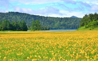
The Daylilies of the Oe wetlands at Lake Ozenuma: Video Introduction This video, titled "Lake Ozenuma in Summer and Hiking Through the Daylilies of Oe Marsh|Daylilies at Lake Ozenuma|A Famous Place for Flowers" (夏の尾瀬沼とニッコウキスゲの大江湿原ハイキング 尾瀬沼のカンゾウ 花の名所 花見頃), was uploaded by "Discover Nippon." Daylilies are a common seasonal flower during summer in Japan, and Oe Marsh is famous for its spectacular view of the flowers. [Video] 0:21 - Oe Marsh The video shows the yellow daylilies swaying in the summer breeze and the beautiful scenery of various highland plants surrounding the marshland and Lake Ozenuma. Be sure to enjoy the beautiful video showing the lush greenery and brilliantly blooming flowers in this 4-minute video. [Video] 0:28 - Highland Plants [Video] 2:07 - Daylilies Oe Marsh – A Popular Attraction at Oze National Park Photo:Daylilies at Oe Marsh Oze National Park is a famous landmark in Japan and is home to Oe Marsh, an attraction known for its beautiful flowers. Oe Marsh lies around the Oe River near the village of Hinoemata, Fukushima and is known for the beautiful daylilies that bloom there. If you go down river, you'll find Lake Ozenuma, which is surrounded by a promenade for visitors to enjoy a relaxing stroll around it. It's an especially popular attraction during the summer months. What Are Daylilies? Facts and Interesting Information About the Famous Flower of Oze National Park Photo:Daylilies The daylilies of Oze National Park are characterized by their dark orange-yellow petals, of which it has six. The best time to see the daylilies at Oze National Park is from late June to August, as they grow at high elevations in the mountains, where temperatures can vary greatly. In Japanese, the daylilies at Oze National Park are called Nikkokisuge (ニッコウキスゲ, 'Nikko Daylilies'), which comes from the fact that there are many colonies of them that can be found growing in Nikko, Tochigi. Other than Oe Marsh, these daylilies can be found at Senjogahara Marshland and in the Kirifuri Highlands of Nikko, Tochigi, where the name originated, as well as in Nagano Prefecture, which is home to the Kirigamine Highlands and Kurumayama Highlands, where the flowers can be found growing in colonies. What makes the flowers so special is the vivid color of their petals. The flower is known to bloom in the morning and close in the evening, and it's almost as if it puts all of its energy into blooming to show you its brilliant beauty. Other Flowers to See at Oe Marsh, a Famous Spot for Flowers in Oze National Park! Photo:Daylilies at Oe Marsh Oe Marsh in Fukushima Prefecture is one of the most famous flower viewing spots in Oze National Park. Oe Marshland is famous for its flowers in summer, but there's a lot more to see than daylilies. Here we'll introduce the best time to view the different flowers around the Oe River from spring to summer, together with the meanings of each flower in Japanese culture. Daylilies A short-lived flower that blooms in the morning and withers in the evening. The bright color of the flower is its distinguishing feature. Best time to see it: Mid-July to late July Language of Flowers: Something new each day Photo:Skunk cabbage Skunk Cabbage At first glance, skunk cabbage looks like a large white flower, but the white part is actually not a petal, but rather a type of leaf called a bract. The white leaves have a strong presence, and the stick-like part of the leaf is surrounded by a flower that looks like an ear. It's popular for its dignified appearance. Best time to see it: Mid-May to early June Language of Flowers: Beautiful memories Photo:Cottongrass at Lake Ozenuma Hare's-Tail Cottongrass In June, small yellow petals bloom from this flower, and by the end of June, they turn into fluffy, white, round heads. The lovely cotton grass blooms all over Oze National Park. Best time to see it: Late June to mid-July Language of Flowers: Wavering thoughts ※The above information is based on the usual flower viewing times for Oze National Park as a whole. The blooming time and best time to see the flowers may vary with the climate of a given year and the altitude of the area the flower is growing, so please view this information only as a reference, not as a guarantee. Let's Go Hiking in Oze – Lake Ozenuma to Oe Marsh: A Walking Course Recommendation for Enjoying the Splendid Scenery of Oze National Park Photo:Lake Ozenuma hiking trails Oze National Park, which boasts a vast area, has a number of hiking courses, some of which are quite advanced and will require an overnight stay at a mountain lodge. We recommend a one-day course that begins at Numayama Pass on the Fukushima Prefecture side of the mountain, passes through Oe Marsh, and returns to Numayama Pass after stopping at Lake Ozenuma. It's a 4.35-mile hike, and the wooden boardwalk is well maintained, making it ideal for hiking beginners and those who want to enjoy a casual hike to see the views in Oze National Park. Oze National Park Day Trip Hiking Course Numayama Pass → Oe Marsh → Lake Ozenuma → Oe Marsh → Numayama Pass Near Lake Ozenuma, there is a famous photo spot as well as the Ozenuma Visitor Center where you can get information about the nature of Lake Ozenuma and Oze National Park by experts on the area. How to Get to Oze National Park From Tokyo How you decide to travel to Oze National Park will depend on which hiking course you plan on using. For the hiking course we listed above, the best way to reach Numayama Pass is as follows. Take the train from Tokyo Station to Aizukogen-Ozeguchi Station (210 mins), then take a bus to Numayama Pass (120 mins). This route will take about 6 hours in total and there will be a couple transfers depending on the line you use. Most trains will take you to Kitasenju Station and from there will be a straight shot to Aizukogen-Ozeguchi Station via the Tobu Line's Limited Express Revaty. Oze National Park From Tokyo Station Tokyo Station → Aizukogen-Ozeguchi Station → Numayama Pass ※The bus from Aizukogen-Ozeguchi Station to Numayama Pass is not in operation from November to March. ※Oike to Numayama Pass is closed from November to mid-May. If you're hiking at a trail starting at Hatomachi Pass or Oshimizu, you can use one of the two following routes. Take the shinkansen from Tokyo station to Jomo Kogen Station (60 mins), and from there take a bus to Togura (戸倉) (120 mins), and from Togura, take a bus to Hatomachi Pass (25 mins). Tokyo Station → Kogen Station → Togura → Hatomachi Pass ※The bus from Togura to Hatomachi Pass is not in operation from November to April. Take the shinkansen from Tokyo station to Jomo Kogen Station (60 mins), and from there take a bus to Togura (戸倉) (120 mins), and from Togura, take a bus to Oshimizu (20 mins). Tokyo Station → Kogen Station → Togura → Oshimizu ※The bus from Togura to Oshimizu is not in operation from November to April. Summary of Summer at Lake Ozenuma and Oe Marsh Currently, there are more than 900 species of alpine plants that inhabit Oze National Park, making it a very unique place to visit in Japan. In order to protect the scenery of Oze National Park, we ask that you please do not leave trash behind or step foot into the wetland area. In the summer, vast mountains and lovely flowers await you in Oze National Park. Whether you're a serious climber or visiting for a casual nature walk, be sure to stop visit! 【TripAdvisor】Oe Marsh -
 Video article 4:00
Superb 4K video of beautiful rice fields in Aizuwakamastu City, Fukushima Prefecture! The scenery of golden rice ears dyed by the setting sun is soothing.
Nature- 533 plays
- YouTube
Video introduction of rural landscape of Aizuwakamastu City, Fukushima Prefecture To us Japanese, our staple food is rice. And where there is rice, there are rice paddies! You'll be completely absorbed by the view of the rice paddies during the autumn season that the 4K video “Japan Rice Paddies in autumn afternoon-views of rice paddies before the autumn sunset 4K (Ultra HD)(Japan Rice Paddies in autumn afternoon - 田んぼの風景・秋の夕暮れ前 4K (Ultra HD))” has to offer. The place where they shot the footage is the paddy field area in Aizuwakamastu of the Fukushima prefecture, in the rice-producing district of Japan's Tohoku region. From the beginning of the video, you can see the Japanese pampas grass around the rice paddy, and from 1:19, the ears of rice slowly being colored into a golden hue can be seen as well. The singing of the insects combined with the melody of the nearby river also relaxes the mind and makes you feel at peace. These kind of rural landscapes aren't uncommon in Japan either. The most Instagrammable, breathtaking sights to behold are the “Senmaida” and the “Tanada”, which are rice paddies or rice terraces that are cut into the steep mountain slope in a stair-like shape. This miraculous scenery is the crystallization of the wisdom of our ancestors. How Much Do You Know About Japan’s Paddy Fields? Photo:Rural landscape The scenery of Japan’s rice paddies is said to be the absolute perfection of inner peace and relaxation. However, how much do you know about Japan's rice paddies? The scientific name for Japanese rice is "Japonica rice" and as you've probably guessed, it originates from Japan. In the history of paddy field cultivation, Indica rice was cultivated in Southeast Asia. However, this rice is different from Japonica rice. The rice eaten in the present day, which has a special characteristic that makes it suitable for the Japanese climate, has a long history of agriculture in Japan. Photo:Rural landscape So, we will now introduce some basic knowledge about the rice paddies of Japan. First of all, the map symbol of a rice paddy is 2 lines. This symbolizes the “Aze” (the furrow between the paddy fields). The rice paddy is thought to be part of an idyllic scenery of nature. However, it is a man-made agricultural land formation, and the furrows are man-made paths between each rice paddy so people can work on the fields. Between the furrow and the rice paddy, there are waterways that help manage water. Paddy fields are measured in units called “Tan” and 1 Tan is about 991.74 square meters big. Rice Paddies and the Divine Photo: White rice Shinto is an original religion of Japan and deifies nature. The highest object of worship is the Emperor. Every year in November, there is The Niiname Festival(新嘗祭,Niiname-sai), held in the Imperial palace, in which the emperor prays for a bountiful harvest in the coming year. During this time, grains that are harvested from a lucky direction as designated through divination, will be eaten by both the Emperor and Empress. As you can see, for Japan, planting rice is not just an act of agriculture; it has significant cultural relevance as well, and rice was also used to pay annual tribute (presently known as taxes) in the past. Therefore, rice paddies were an important infrastructure that have supported the very heart of Japan since ancient times. How to Make Paddy Fields Photo:Rice planting Rice cultivation is in autumn. Depending on the region, however, usually the preparation of rice beds and seedlings start around March. There are many things that need to be done to prepare for rice planting as well: repairs on furrows, spreading of fertilizer, plowing and irrigating the fields ( to prevent damage from weeds or water leakage), filling the paddies with water, and then finally planting the rice seedlings. Come summertime, weed killers and pesticides are used to manage the growth of the rice, and in autumn the rice is harvested, some made into seedlings again, and the rest is threshed and put on a rice rack to dry. Referred to as "tilling", this act involves creating hills and soil beds in the rice field, as well as creating ice-field furrows and dams. In the modern day, much of the work is mechanized, however, in the past this was all done by hand. Summary of Japan’s rice paddies Photo:Rice paddy in Summer A rice paddy and a regular farm field are very different in terms of plowing, and grains other than rice are made in regular fields but not in rice paddies. That just goes to show how special of a crop rice is to the Japanese people. Also, because rice paddies are abundant with water, many living creatures gather near them, such as the aquatic stink bug, the diving beetle, the pond snail, and sparrows. Sometimes damage to crops does occur, however, there is a very rich ecosystem within the paddy fields. Recently, the aging of the rice farmers has led to many rice fields being fallowed. The original scenery of Japan, “Sunset on the rice paddies” is an incredible view that we want to preserve for future generations. -
Video article 5:41
The Magnificent Cliffs That Tower Over Iwate Prefecture! A Stunning View of One of the Most Scenic Spots in the Tohoku Region!
Nature- 41 plays
- YouTube
This video, titled "Iwate Cliffs and Coasts - Iwate - 岩手県の崖と海岸 - 4K Ultra HD," was released by "TokyoStreetView - Japan The Beautiful." The cliffs and coasts of Iwate Prefecture featured in this video show a stunning contrast between one of the steepest cliffs in the Tohoku region and the beautiful azure blue of the Pacific Ocean. The video introduces the majestic Unosu Cliff (2:54), a series of five cliffs draped in a beautiful row that can only be seen in Iwate Prefecture, and the Sannoiwa Rocks (4:00), rocks that rise up from the surface of the sea. The combination of white waves and marine blue seen through the pine tree lined promenade is a wonderful contrast between the movement of the waves and the stillness of the shore, and will have you feeling as if you're looking at an ukiyo-e painting. -
Video article 3:31
The Beautiful Sight of 1,200 Brilliant Hydrangeas in Full Bloom! Take a Moment to Relax and Enjoy the Nature, History, and Culture of Sendai, Miyagi!
Nature- 769 plays
- YouTube
Video introduction to Shifukuji Temple, a hydrangea temple in Sendai City, Miyagi Prefecture This time, we introduce a video titled "[4K]Ajisai Temple: 1200 hydrangea flowers in the shifukuji temple, Miyagi Japan".([4K]Ajisai Temple 仙台のあじさい寺・資福寺に咲く1200株の紫陽花 hydrangea flower in the shifukuji temple, Miyagi Japan) The video shows the precincts of Shifukuji Temple in full bloom with hydrangeas at their best. What is Sendai Hydrangea Temple "Shifukuji"? Highlights and history Shifukuji Temple, also known as the Hydrangea Temple (あじさい寺, Ajisai-dera), is located in Kitayama, Aoba Ward, Sendai, Miyagi Prefecture in the Tohoku region of Japan (Miyagi-ken Sendai-shi Aoba-ku Kitayama). The temple is formally known as the Shiunzan Shifukuji Zen Temple (慈雲山 資福禅寺, Shiunzan Shifukuji-zen-dera) of the Myoshinji Sect of the Rinzai school of Buddhism (臨済宗妙心寺派, Rinzai-shu Myoshinji-ha). As suggested by the name "Hydrangea Temple," Shifukuji Temple is known for its more than 1,200 bunches of blooming hydrangeas. The temple is a popular sightseeing destination in Sendai. An especially popular and Insta-worthy spot is the hydrangea-lined path leading to the sanmon gate. This can be seen at 0:56 in the video. Shifukuji Temple (Hydrangea Temple) has a long and rich history. It was originally constructed in Takahata Town, Yamagata Prefecture (山形県高畠町, Yamagata-ken Takahata-machi) in the Tohoku region of Japan. During the Warring States period (1467~1615), Kosai Soitsu (虎哉宗乙, Kosai Soitsu) became the chief priest of the temple. After Kosai became the educator of Sendai’s feudal lord Date Masamune (伊達政宗, Date Masamune), the temple was moved to Sendai. The ruins of the former Shifukuji Temple can still be found in Takahata Town, along with the graves of Date Masamune’s ancestors and Endo Motonobu (遠藤基信, Endo Motonobu), one of the Date clan’s chief vassals. Shifukuji Temple is also known for the statue of Ninomiya Sontoku (二宮金次郎, Ninomiya Sontoku). When is the best time to see hydrangeas at Shifukuji Temple? Sendai Hydrangea Temple "Shifukuji" has about 1,200 hydrangea plants in its precincts. The best time to view them is usually from mid-June to early July. The best time to view them depends on the weather, so please check the weather information website for the blooming conditions. Access to Sendai’s Hydrangea Temple Photo:Shifukuji・Hydrangeas Parking spaces are available behind the Main Hall of Shifukuji Temple. However, as the roads leading to the temple are narrow, we recommend that visitors take public transportation such as buses. The peak viewing season for the hydrangeas is late June, and many events, such as matcha-tasting at Shoshoin (小書院, Shoshoin), are held. However, as many visitors congregate during this time, it can be difficult to find a free parking space. In addition, a zen meditation session is held on the 1st of every month. This is also a popular event that draws many visitors. What is the language of flowers for the hydrangea variety? Photo:Shifukuji・Hydrangeas Hydrangeas bloom during Japan's rainy season, and appear in shades of white, purple, blue and red from May to July, growing to about 1m to 2m. In Japan, they symbolize both a young girl’s love or persevering love, as well as the opposing meaning of capriciousness and betrayal. The latter meaning is thought to be derived from the fact that the flowers' color changes depending on the quality of the soil. The colorful cluster which is frequently mistaken for flowers is actually the calyx of the hydrangea, with the flower petals hidden in the middle of the cluster. This is where pollination occurs and seeds are formed. The hydrangea is native to Japan, China, Taiwan and South America. They are deciduous shrubs of the Hydrangeacae family, and are also known as the Western hydrangea. The various species of hydrangea include the hydrangea macrophylla f. macrophylla, hydrangea quercifolia, hydrangea serrata, as well as the hydrangea macrophylla f. normalis. Recommended for beginner growers? How to grow "Hydrangea Photo:A potted Hydrangea The cultivation and care of hydrangeas is fairly simple, making it great plant even for beginners at gardening. For potting, first cut 2 centimeters off the stem of the hydrangea. Place the cut stem in water for about 30 minutes. In the meantime, place a net at the bottom of the pot, then fill the pot with Kanuma soil or Akadama soil and then moisten it. Next, create an opening to insert the cut stem. In about one month’s time, roots will grow. After the roots have grown sufficiently, transfer the shrub to a large pot. Place the pot in a place with plenty of sunlight, water the shrub frequently, and the hydrangea will grow healthily. View Hydrangeas at Sendai's Hydrangea Temple! Photo:Shifukuji・Hydrangeas How about it? Revitalize yourself and enjoy the sight of colorful hydrangea at the Hydrangea Temple! Furthermore, besides the hydrangea season, during other times of the year, you can enjoy the majestic bamboo forest as well! There is even a goshuin (commemorative seal stamp) available. This can be seen at 1:50 in the video. ◆Shifukuji Temple Overview of Facilities◆ 【Address】〒981-0931 Miyagi Prefecture Sendai City Aoba Ward Kitayama 1-13-1 【Access】12 minutes walking from Kita-Sendai Station on the JR Senzan Line (仙山線 北仙台駅, Senzan-sen Kita-sendai-eki) 【Parking】Free, with around 50 spots available 【Telephone No.】022-234-5730 【Tripadvisor】Shifukuji Temple https://www.tripadvisor.jp/Attraction_Review-g298249-d14920878-Reviews-Shifuku_ji_Temple-Sendai_Miyagi_Prefecture_Tohoku.html -
Video article 4:00
The Autumn Leaves of Tsutanuma Lake - Experience the Fantastic Beauty of Mother Nature in This Secluded Area in Towada, Aomori via Video
Nature Travel- 285 plays
- YouTube
Autumn Leaves at Tsutanuma Lake in Towada, Aomori: Video Introduction This video, titled "Perfect Fall Foliage Reflections at Tsuta Numa Lake - (shot on BMPCC6K)" ([4K] 紅色の絶景 美しすぎる蔦沼の紅葉 - Perfect Fall Foliage Reflections at Tsuta Numa Lake - (shot on BMPCC6K)), was uploaded by "AQUA Geo Graphic." The video, which is less than four minutes long, introduces the breathtaking views of nature in Aomori, Japan. Tsutanuma is a secluded area at the foot of the Hakkoda Mountains in Japan's Aomori Prefecture. The trees are dyed a fiery red in the morning sun, and the still surface of the lake becomes a mirror, reflecting the magnificent red and orange foliage. The contrast with the clear blue sky is also wonderful, and the video allows viewers to experience something not often found in nature. [Video] 0:30 - Autumn Leaves Reflecting on the Surface of Tsutanuma Lake Characteristics and Highlights of Tsutanuma Lake, a Place Surrounded by Magnificent Natural Scenery Photo:Akanuma Pond, Hakkoda, Aomori Tsutanuma Lake is a secluded area deep in the Hakkoda Mountains of Aomori Prefecture, located 460 meters above sea level. The lake has a circumference of 1 km and an area of about 15 acres. It is one of seven marshes, lakes, and ponds (Tsutanuma, Kagaminuma, Tsukinuma, Naganuma, Suganuma, Hyotan-numa, and Akanuma) scattered throughout the prefecture, and is popular as a place for viewing the autumn leaves. The area around Towada-Hachimantai, including Tsutanuma Lake, was designated as Towada-Hachimantai National Park in 1936, and is an area where virgin forests of beech trees and other pristine natural features remain. The area is also a wildlife protection area for birds and animals, as it's home to a variety of wild birds, making bird-watching very enjoyable here. The "Marsh Tour" (沼めぐりの小路, Numa-meguri no Koji) is a 2.9 km circuit of six marshes (excluding Akanuma), which takes visitors counterclockwise from the Visitor Center to Tsutanuma, Kagaminuma, Tsukinuma, Naganuma, Suganuma, and Hyotan-numa, in that order, through beautiful beech forests. The course takes about one and a half hours to complete, depending on how fast you walk. You can enjoy the breathtaking seasonal scenery as you stroll along. The Autumn Foliage Season at Tsutanuma Lake – When to Visit and How to Make Reservations Photo:Tsutanuma Lake, Aomori The autumn leaves at Tsutanuma usually appear from mid-October to early November. The best time to visit is early in the morning from 6:00 to 6:30 a.m. The spectacular view of the crimson autumn leaves illuminated by the early morning sun, as shown in the video, is a sight that can only be seen before the sun has fully risen. However, please note that prior reservations and a "cooperation fee" are collected when touring Tsutanuma. The purpose of this is to prevent congestion and protect the environment so that the beautiful Tsutanuma can be enjoyed by future generations. Advance reservations are required to access the observation deck in the early morning. Also, daytime sightseeing does not require advance reservations, but a "cooperation fee" system is in place for both early morning and daytime viewing. Please keep this in mind when planning your visit, and enjoy sightseeing while respecting proper etiquette. [Video] 0:10 - Autumn Leaves Blazing Crimson in the Morning Sun The Four Seasons of Tsutanuma Lake and the Secluded Hot Springs of Tsuta Onsen Photo:Tsuta Onsen If you visit Tsutanuma, be sure to stop by Tsuta Onsen Ryokan. It's a hot spring inn located near the entrance to Oirase Gorge, surrounded by a forest of beech trees and abundant greenery. Tsuta Onsen has a long history, and is a hidden hot spring that has been flowing for 1,000 years, which is very rare, even in Japan. Tsuta Onsen is also conveniently located approximately 5 minutes on foot from "Numa-meguri no Koji," a course for exploring the seven lakes. It's also only a 20-minute drive to the Oirase Gorge and a 40-minute drive to the Hakkoda Ropeway, making it easy to access nearby tourist attractions. Embraced by pristine nature, Tsutanuma is a popular spot not only for tourists, but also for photographers, as it offers a different look in each of the four seasons, leading to many repeat visitors who visit every season. Outside of autumn, the area offers a variety of seasonal landscapes, including fresh greenery in the spring, fog and fireflies in the summer, and snowy landscapes in the winter. Summary of Sightseeing at Tsutanuma Lake Tsutanuma isn't a place mentioned by many travel guides, but most people in Japan are familiar with the Hakkoda Mountains. In addition to strolling around Tsutanuma Lake, you can also visit the surrounding tourist spots such as Oirase Gorge, Lake Towada, and the Hakkoda Mountains in about 40 minutes by car. Also, the Hachimantai area, including Tsutanuma, is one of the most prominent volcanic areas in Japan, and there are many hot spring resorts scattered around Towada-Hachimantai National Park. You can see magnificent scenes of nature all around that will help you forget your everyday life, and you can also take many photos that will look great on Instagram. Take a trip to Towada-Hachimantai in Michinoku and immerse yourself in the great nature of Aomori in north-eastern Japan. 【TripAdvsior】Tsutanuma Lake https://www.tripadvisor.com/Attraction_Review-g1059454-d1367829-Reviews-Tsutanuma_Pond-Towada_Aomori_Prefecture_Tohoku.html -
Video article 5:28
Drone aerial photography animation of autumn leaves of “Jogakura Ohashi” in Aomori-city, Aomori-prefecture, Japan! The autumn leaves spreading all over the background of the bridge are impressive! Thinking about the origins of the bridge!
Nature Travel- 200 plays
- YouTube
Video introduction of “Jogakura Ohashi” Autumn Foliage in Aomori City, Aomori Prefecture This video, titled "[Drone] Jogakura Bridge, Aomori / Aerial Drone Shots of Jougakura Bridge [4K]" (【Drone】青森 城ヶ倉大橋 / Aerial Drone Shots of Jougakura Bridge【4K】), was uploaded by "TinyBetter Drone Works 4K." The video showcases magnificent views of autumn foliage against the backdrop of the Jogakura Bridge in Aomori, Japan. We hope you enjoy the magnificent views captured via drone accompanied by wonderful music. Jogakura Bridge – Facts About the Beautiful Bridge in Aomori, Japan Photo:Jogakura Bridge, Aomori, Japan Jogakura Bridge is located in Towada-Hachimantai National Park in Aomori, in Japan's Tohoku region. National Route 394 connects the Tsugaru and Nanbu regions of Aomori Prefecture, and in October 1995, Jogakura Bridge was built over Jogakura Gorge, which had been a major obstacle previously. Needless to say, a great deal of effort was put into building the bridge, and many people worked hard to make it possible. Jogakura Bridge is 360 meters long, with an arch span length measuring 255 meters. It is the longest deck arch bridge in Japan, which have their deck is completely above the arch. The arch span length is the length of the bridge between the piers (the main span). The height from the valley floor is 122 meters! The view of the Hakkoda Mountains from the bridge is truly spectacular. The Best Time to View Autumn Leaves at Jogakura Bridge Photo:Autumn leaves from Jogakura Bridge, Aomori, Japan From Jogakura Bridge, visitors can enjoy views of the Hakkoda Mountains throughout Japan's four seasons, but autumn is especially popular, when the autumn leaves change to beautiful shades of red and orange. The best time to view the autumn leaves is in mid-October, and the picturesque scenery of the autumn leaves stretching far into the distance is a must-see. Mt. Iwaki, one of the 100 Famous Japanese Mountains, can be seen on the west side of the mountain. The view of Mt. Iwaki beyond the autumn leaves is one of the highlights of Jogakura Bridge, and will surely make for some great shots for any instagrammers or photographers out there. There are parking lots and restrooms at both ends of the bridge. From the observation space on the Kuroiwa side of the parking lot, visitors can take pictures of the arch bridge against the backdrop of autumn leaves. You can walk across the bridge's walkway and take your time snapping photos while viewing the autumn leaves. You can see tourists doing this throughout the video as well. Because it's filmed via drone, you can also see just how large and tall the bridge actually is. [Video] 1:25 - Tourists Walking Across the Bridge, Enjoying the Autumn Leaves Peering into Jogakura Gorge below, can be a bit daunting if you're afraid of heights. There used to be a walking trail that led down to Jogakura Gorge below the bridge, but it's now closed due to hazardous sections. Although you can't get up close to Jogakura Canyon, you can enjoy the panoramic view from 122 meters in the air. Hot Springs, Ropeways, and Other Popular Attractions Around Jogakura Bridge Photo:The Hakkoda Ropeway ●Sukayu Onsen This hot spring has been known as a therapeutic bath since the Edo period (1603-1868 A.D.). "Hiba Senninburo," a large, 290 square meter mixed bathing area constructed entirely of hiba (cypress), is what makes this hot spring so special. The retro atmosphere is also popular. ●The Hakkoda Ropeway Located in the northern part of Towada-Hachimantai National Park, the ropeway connects the base station and the summit park station via a 10-minute gondola ride, offering spectacular seasonal views, such as autumn leaves in the fall and ice-covered trees in winter. From the ropeway station, a walking trail is available where visitors can enjoy a 30-60-minute stroll. ●Jigoku-numa Pond A swamp created as a result of the former volcanic activity of the Hakkoda Mountains, located not far from Sukayu Onsen Hot Spring. Even today, sulfur-containing gases spew forth from the surrounding fumaroles, and highly acidic, 90-degree Celsius water gushes into the pond. Summary of Jogakura Bridge Jogakura Bridge, built in a harsh natural environment high in the air, features a spectacular panoramic view. Did you get a chance to check out the beautiful autumn leaves in the video? In addition to the autumn foliage, winter, spring, and summer are also beautiful, so if you get the chance, we definitely recommend visiting during these seasons as well. There is also a well-known soba restaurant near Jogakura Bridge. Some serve tempura made with vegetables grown in the surrounding mountains with soba, while others even have tempura apples, a specialty of Aomori Prefecture, and others even have soba pudding! Enjoy the vast nature of Towada-Hachimantai National Park while also enjoying some delicious local food! 【TripAdvisor】Jogakura Bridge https://www.tripadvisor.com/Attraction_Review-g298241-d2471814-Reviews-Jogakura_Bridge-Aomori_Aomori_Prefecture_Tohoku.html -
Video article 2:13
Zao - Where Fantastic Ice Trees Stretch as Far as the Eye Can See. Referred to as "Ice Monsters" This Destination in Yamagata Prefecture Is Very Popular Among Foreign Tourists
Nature- 123 plays
- YouTube
自然が生み出す絶景「蔵王の樹氷」をご紹介! 日本にはさまざまな名所があります。 その中でも幻想的な景色を楽しめる場所に旅行したいと思っている方は多いと思います。 そのような方々に、山形県の蔵王の樹氷をおすすめします。 この記事では、「Saha Entertainment TV」が公開した「[4K] 絶景蔵王の樹氷 Amazing Ice Monsters」をもとに、日本のおすすめの観光地である蔵王の樹氷の魅力や、おすすめのインスタ映えスポットの情報などを説明します。 「蔵王の樹氷」が生み出す自然の美しさ 蔵王の樹氷は、山形の蔵王連峰にある植物に雪が凍り付き、固まったものです。 東北地方の奥羽山脈(飯豊連峰、朝日連峰、月山、鳥海山など)でしか確認されておらず、とても珍しい自然美を堪能することができます。 見ごろは、1月の下旬から3月の上旬です。 この時期には樹氷のライトアップイベントも行われているので、夜の幻想的な蔵王の樹氷を楽しめます。 このように、蔵王の樹氷は他では見ることができない美しい絶景を楽しめるので、自然を楽しみたい方にはおすすめの観光地です。 「スノーモンスター」や「アイスモンスター」とよばれる蔵王の樹氷を思う存分、鑑賞しましょう。 日本の観光地である「蔵王の樹氷」は幻想的な景観を楽しめる 日本の観光地である蔵王の樹氷は、幻想的な景観を楽しむことができます。 昼の太陽の光によるデイライト樹氷は、自然の光と特徴的な形の樹氷が融合して、少し変わった美しい風景を楽しむことができます。 夜のライトアップでは、色彩が鮮やかな光によって樹氷が浮かびあがり、幻想的な景色を堪能できるでしょう。 蔵王の樹氷は、昼と夜で幻想的な景色を見ることができる素晴らしい場所です。 日本の観光地である「蔵王の樹氷」を見るのにおすすめのエリア 日本の観光地である蔵王の樹氷は、自然の景色を満喫できるスポットがたくさんあります。 温泉街からのれるロープウェイは、大きな窓から樹氷を見ることができるのでおすすめです。 ゆったり座りながら鑑賞できるのもポイントです。 ロープウェイの山頂駅も人気スポット。 駅から降りた瞬間に広大な樹氷が目の前に広がっています。 展望台では樹氷原を一望できるので、ぜひ訪ねてみてください! 絶景「蔵王の樹氷」のまとめ 他では見ることができない蔵王の樹氷。 ぜひ現地でアイスモンスターと呼ばれる絶景をご覧になってみてください。 その幻想的な景色と迫力を思う存分、楽しみましょう! -
Video article 3:13
Autumn Leaves in Hakkoda, Aomori - The Reflection of This Beautiful Red Foliage Is Poetic
Nature- 706 plays
- YouTube
Tourist Information for Viewing the Autumn Colors in Hakkoda and the Tsugaru Plains in Aomori This tourism promotional video (made by JAPAN GEOGRAPHIC) highlights the renowned autumn foliage in Hakkoda. Although Japan boasts many scenic sites to practice the traditional autumn foliage viewing, one of the 100 most beautiful Japanese mountains, Mt.Hakkoda has been very popular for the viewing of autumn colors in the countryside. The breathtaking view of autumn foliage reflected on the lake surface attracts a great number of visitors. The video navigates us through the beauty of autumn-colored Hakkoda which often appears on well-known travel sites or TV programs, and also has been a regular winner of the ranking of places in Japan to see autumn colors. Autumn leaves are best seen on a sunny day. The sunlight makes the red and yellow leaves shine. Winter comes early up in the north in Aomori. Such meteorological conditions give leaves vibrant colors. The video captures the spectacular color display in Hakkoda. Hakkoda: From Hot Springs to Beautiful Autumn Foliage Photo:Kenashitai Wetlands dyed in autumn colors Some hiking trails are maintained in Hakkoda so that hikers can take in the splendid autumn color display in the clear air, or enjoy the sounds of walking through the deciduous forests on a carpet of fallen leaves. Aomori Prefecture features many renowned hot springs. Staying at an Onsen Ryokan located in the area such as Sugayu Onsen (a very charming old-fashioned onsen hotel), Jogakura Onsen, or Tsuta Onsen will make your trip even more special. The recommended hiking route is an excellent 5-hour circular walking trail that starts and ends at Sugayu Onsen. The route takes you up to Mt. Otake and leads to the vast marshlands of Kenashitai. As plenty of visitors are expected during the peak of the autumn colors, it is better to book your room in advance. The Best Sightseeing Spots in Hakkoda Source :YouTube screenshot Aomori is one of the most popular tourist destinations in Japan. When it gets a color makeover from the autumn foliage, places like Mt. Hakkoda, Oirase Gorge, Zenkojidaira, Mutsu Bay or Jyogakura Oohashi are filled with tourists hunting for vibrant colors. Look at the breathtaking autumn vistas at Jigokunuma starting at 0:50! The red tinge with yellow, and vivid orange hues.... The stunningly beautiful color display is made mainly of Beech, Japanese rowan trees (nanakamado) and maple trees. "Tsutanuma Lake" (from 1:20 -) laying at the foot of Mt. Hakkoda is a hidden gem of the area. With the red leaves floating on the water, the lake has a mysterious beauty. The image of Lake Towada reflecting the mountains of autumn colors on its surface (from 1:42) is something you never get tired of looking at it. This explains why it is a photographers' dream destination. The symbolic scenery of the turning of autumn leaves contrasted with the water's surface is a magnet that pulls tourists back to this location. A Walk in the Sky With Hakkoda Ropeway Photo:Mt. Hakkoda, Ropeway The nighttime illumination during the autumn season allows visitors to admire the colors of autumn foliage from the sky until late hours. The approximately 10-minute sky walk in a gondola takes you up to the summit of Mt. Tamoyashidake offering you a look out of the colorful autumn mountains. Road Trip Information to Hakkoda in Autumn Photo:Autumn Leaves at Hakkoda Mountain Autumn foliage in the Tohoku region typically peaks from the beginning to the end of October. The route twisting through the mountains gives travelers a diverse views of the autumn leaves. From JR Aomori station, it takes about an hour to drive to Hakkoda. There is some parking in the area. Summary : 360° Panorama View From the Summit of Hakkoda - 4k Video of Autumn Colors Hakkoda is crowded with both domestic and international tourists in the autumn season, so we recommend checking traffic information and accommodation availability provided by the tourist information websites. Enjoy the video of the majestic autumn colors in Hakkoda! 【Tripadvisor】Hakkoda Mountains https://www.tripadvisor.com/Attraction_Review-g298240-d556800-Reviews-Hakkoda_Mountains-Aomori_Prefecture_Tohoku.html 【Official Website】Aomori Prefecture Tourist Information SIte - Aptinet https://www.en-aomori.com/ -
Video article 4:05
This is exactly what Instagram looks like! Goshiki-numa" in Kitashiobara-mura, Fukushima Prefecture The cobalt blue surface of the water is a mysterious sight that is out of this world!
Nature Travel- 308 plays
- YouTube
Sightseeing Video Introduction of "Goshikinuma" in Kitashiobara-mura, Yama-gun, Fukushima Prefecture This video, titled "Goshikinuma - A Fantastic Colored Pond in Fukushima Japan" (Fantastic Colors Pond in Fukushima Japan 五色沼湖沼群 神秘的な絶景の福島裏磐梯・東北の美しい風景), introduces the beautiful cobalt blue lakes of "Goshikinuma," located on the north side of Mt. Bandai (津磐梯山, Aizu Bandaisan), in Fukushima Prefecture, located in Japan's Tohoku region. "Urabandai" in Fukushima Prefecture has about 30 small and large lakes and swamps, which are characterized by various shades of green, red, and blue. It is also called the "Mysterious Lake" because of its beauty, and has received one Michelin Green Guide star. Please enjoy the scenic beauty of nature during the season when the fresh greenery is at its best. What Is Goshikinuma Like? Photo:Benten-numa at Goshikinuma Goshikinuma consists of Bishamon-numa (毘沙門沼, Bishamon-numa), Aka-numa (赤沼, Aka-numa), Midoro-numa (みどろ沼, Midoro-numa), Benten-numa (弁天沼, Benten-numa), Ruri-numa (るり沼, Ruri-numa), Ao-numa (青沼, Ao-numa), and Yanagi-numa (柳沼, Yanagi-numa), which are introduced from the beginning of the video. In addition to the cobalt blue lakes, the fresh greenery is reflected on the water's surface as shown in the video at 1:56, and the emerald green Ruri-numa is also beautiful. There are also swamps that show different colors depending on the season and weather, such as emerald blue, turquoise blue, and pastel blue. You can rent a rowing boat in Bishamon-numa, so we recommend that you take your time and enjoy the beauty of nature. Sightseeing at Goshikinuma Photo:Bishamon-numa Bandai Asahi National Park (磐梯朝日国立公園内, Bandai Asahi Kokuritsu Koen) in Fukushima Prefecture is a special protected area. The area around the scenic Goshikinuma in April is a hiking course where you can enjoy cycling. Be sure to choose a sunny day to go on a sightseeing trip. It's a good idea to walk along the Goshikinuma Nature Exploration Road when the autumn leaves are at their most colorful. There are gourmet spots where you can enjoy lunch, accommodations such as the Goshikinuma Hotel, campsites, and holiday villages as well. Make sure to book accommodations and tours, to travel around at and enjoy the surrounding sights. Sightseeing Spots Around Goshikinuma Photo:Hibara Lake When you come to Goshikinuma for sightseeing, you should definitely check out the nearby sightseeing spots. Recommendations include Mount Bandai's largest lake "Hibara Lake," which is located in the center of the plateau, "Urabandai Roadside Station" for local gourmet and sweets, the drive course "Bandai Azuma Lake line," and "West Azuma Sky Valley" overlooking the superb view. Goshikinuma Sightseeing Video Summary Goshikinuma in Fukushima Prefecture is a hidden sightseeing spot with a beautiful cobalt-blue lake surface. We hope the beauty was conveyed through the video. The sparkling lake is so attractive that you won't get tired of looking at it even if you spent the rest of your life doing so. If you are going on a sightseeing trip to Goshikinuma in Fukushima Prefecture, please enjoy the miraculous scenery, created by nature, to your heart's content. ◆Goshikinuma Lakes and Marshes Overview◆ 【Address】〒966-0401 Kita-Shiobara-mura, Yama-gun, Fukushima 【Access】25 minutes by bus from Inawashiro Station on the Banetsu West Line 【Parking】 Available 【Telephone No】0241-32-2850 【Tripadvisor】Goshikinuma https://www.tripadvisor.com/Attraction_Review-g1120994-d1222009-Reviews-Goshikinuma_Lake-Kitashiobara_mura_Yama_gun_Fukushima_Prefecture_Tohoku.html -
Video article 1:32
Mt. Adatara, Fukushima – Autumn Leaves, Ropeways, and Hiking
Nature Travel- 337 plays
- YouTube
Autumn Leaves on Mt. Adatara, Fukushima: Video Introduction Photo:Kurogane Lodge and autumn leaves on Mt. Adatara, Fukushima Prefecture This video, titled "World's First|Autumn Leaves on Mt. Adatara|6K Video" (世界初 紅葉の安達太良山 6K撮影), was uploaded by "International Drone Association" (国際ドローン協会). This 6K video captures the beauty of the autumn leaves of Mt. Adatara as seen from the sky using a drone. Enjoy the incredible views of Mt. Adatara that you simply cannot see from the ground. [Video] 0:32 - The Colorful Autumn Leaves on Mt. Adatara Mt. Adatara Overview Photo:Mt. Adatara, Fukushima Prefecture Located in central Fukushima Prefecture, Mt. Adatara is an active volcano with an elevation of approximately 1,700 meters and has been selected as one of the 100 Famous Japanese Mountains. The beautiful Mt. Adatara, which appears in ancient texts and classic Japanese movies, is well known both inside and outside of the prefecture. The ropeway makes it easy for beginner hikers to reach the summit, while intermediate and advanced courses are also available. From spring to fall, the mountain is crowded with hikers enjoying the beautiful scenery. Mt. Adatara Ropeway & Parking Information Photo:Mt. Adatara Ropeway, Fukushima Prefecture Adatara Kogen Ski Resort is located at the foot of Mt. Adatara, and there is a ropeway station at the foot of the mountain near the ski resort and a free parking lot that can accommodate up to 1,500 vehicles. A 10-minute ropeway ride will take you to the summit station of Mt. Yakushi (1,350 meters above sea level). From there, it takes about 1 hour and 20 minutes on foot to reach the summit of Mt. Adatara. During autumn, when the leaves change color, there are days when there are lines to board the ropeway, and depending on how crowded it is, you may also have to pay for parking. Because of this, we recommend doing some research before visiting. The ropeway costs 1,200 yen (one-way) and 2,000 yen (round-trip) for adults, and 900 yen (one-way) and 1,500 yen (round-trip) for children. In addition to group discounts and discounts for persons with disabilities, there are also special discount tickets available exclusively on the ropeway's website and discount packages for hot springs and Tohoku Safari Park, so be sure to check the Adatara Ropeway website for details. When to Visit to See the Autumn Leaves on Mt. Adatara Photo:The view from Yakushidake Panorama Park, Fukushima Prefecture Mt. Adatara, famous for its autumn foliage, usually attracts many tourists and climbers, as well as many photographers who come to take pictures of the spectacular scenery. The best time to view the autumn leaves is from late September through October. The best place to take pictures of the spectacular autumn foliage is Yakushidake Panorama Park, located just beyond the ropeway summit station. The park has a 300-meter promenade where visitors can relax and enjoy the spectacular panoramic view of the autumn leaves. Hiking On Mt. Adatara – Trails, Hiking Time, Etc. Photo:The summit of Mt. Adatara, Fukushima Prefecture Mt. Adatara is a popular mountain for hiking and trekking with even beginner hikers due to its relative ease. The recommended hiking course is the approximately 9-km long, 4-hour course that starts from the ropeway summit station. Mt. Adatara Ropeway Summit Station (ロープウェイ山頂駅) → Senjo-daira Trail (仙女平分岐) → Adatara Summit (安達太良山頂上) → Mine no Tsuji (峰の辻) → Kurogane Lodge (くろがね小屋) → Seshitaira Trail (勢至平分岐) → Okudake Trailhead (奥岳登山口). There is a walking trail near Mt. Adatara Ropeway Station, but it has been closed for the time being due to heavy rainfall during the summer of 2022. Mt. Adatara is great for hiking during the fall, but also during the summer and spring as well, so consider visiting during different seasons to enjoy the various scenery! Hot Springs Near Mt. Adatara Photo:Kurogane Lodge and winter on Mt. Adatara, Fukushima Prefecture Kurogane Lodge, a mountain lodge on Mt. Adatara, has a hot spring bath with free-flowing hot-spring water, which is popular among climbers. It's available for day-trip bathing, but as of 2023 Kurogane Lodge is under reconstruction and is therefore unavailable; it's scheduled to be reopened in 2025, so be sure to visit when it's completed. There is also a day-trip hot spring facility called "Adatarayama Okudake no Yu" near the ropeway station at the foot of the mountain, which is used by many hikers in the summer and skiers in the winter. Both Kurogane Lodge and Adatarayama Okudake no Yu have unique acidic springs that are said to be good for relieving fatigue, fighting against nerve and muscle pain, and also help beautify the skin. It's a good place to relax and heal your body after a day of hiking to see the autumn foliage. Admission is 700 yen for adults (junior high school students and older) and 500 yen for children (ages 4 to elementary school students). Skiing on Mt. Adatara Photo:Ski tracks in the snow on Mt. Adatara, Fukushima Prefecture During the winter (December - March), the Mt. Adatara Ropeway transforms into Adatara Kogen Ski Resort. Adatara Kogen Ski Resort features 8 courses and relatively cheap lift tickets. Pricing (1-day Pass/Weekdays): Adults (Junior-high school students and older): 3,500 yen, Seniors (60+): 3,100 yen, Children (Elementary school students and younger): 2,200 yen. Pricing (1-day Pass/Weekends): Adults (Junior-high school students and older): 4,300 yen, Seniors (60+): 3,800 yen, Children (Elementary school students and younger): 2,600 yen. Besides the passes listed above, there are a number of other tickets available to help fit your itinerary, plans, and budget. Summary of Mt. Adatara Photo:Winter on Mt. Adatara, Fukushima Prefecture Mt. Adatara is a mountain that attracts climbers not only during the fall when the leaves change color, but throughout the entire year. In summer, an illumination event is held at Adatara Kogen Ski Resort, making it a popular summer spot. ※In 2022, the illumination was held from July 30 to September 19, from 7:00 pm to 9:00 pm each day. A chain of mountains and beautiful blue skies... Mt. Adatara is a place you'll want to visit again and again to discover the breathtaking scenery in each season. 【TripAdvisor】Mt. Adatara -
Video article 3:09
The Carpet of the Gods – Aerial Footage of Autumn Leaves on Mt. Kurikoma. Experience a Sea of Clouds, Sunrise, and Brilliant Autumn Colors on the Mountain Spanning Miyagi, Iwate, and Akita Prefectures!
Nature Travel- 350 plays
- YouTube
The Carpet of the Gods – Autumn Leaves on Mt. Kurikoma: Video Introduction This video, titled "Autumn Leaves on Mt. Kurikoma|The Carpet of the Gods|Amazing Aerial Footage (Shot on a Phantom 4 Pro)" (栗駒山の紅葉 神の絨毯 絶景空撮 - Autumn Foliage at Mt.Kurikoma, Aerial Footage - (shot on Phantom 4 Pro)), was uploaded by "AQUA Geo Graphic." Straddling Miyagi, Iwate, and Akita prefectures, Mt. Kurikoma is a mountain known for its beautiful autumn leaves. Its appearance is said to resemble that of a carpet for the gods. Mt. Kurikoma is a bucket-list location, and this video shows footage of the breathtaking mountain from the sky. Be sure to check it out as you read along. The Beautiful Autumn Colors of Mt. Kurikoma Photo:Mt. Kurikoma, Miyagi Prefecture Mt. Kurikoma is a 1,626-meter-tall volcano located in the central Tohoku region of Japan. It's known for its abundance of alpine flora, and is popular not only for hiking in the fall, but also in the spring and summer. Thanks to its many deciduous trees, including primeval beech forests and maple trees, the entire mountain changes color in autumn. The summit is of course spectacular, but the mountain features excellent viewpoints for the red and yellow autumn leaves as you hike your way to the top. The mountain is crowded with hikers who come to see the beautiful autumn leaves in the fall. There are nine different hiking courses on Mt. Kurikoma, and hikers can choose the one that best suits their fitness level and experience, which is one of the reasons it's so popular. When to See the Autumn Colors on Mt. Kurikoma Photo:The Carpet of the Gods - Autumn on Mt. Kurikoma Mt. Kurikoma is usually at its best from late September to mid-October. The autumn foliage begins near the summit and gradually spreads over the entire mountain, creating what is called "The Carpet of the Gods," as seen in the video. In 2022, the autumn foliage reached Iwakagami-daira at the trailhead on October 6. The "Carpet of the Gods" is so beautiful you can't help but gasp [Video] 0:33 - Autumn Leaves and the "Carpet of the Gods" on Mt. Kurikoma The entire mountain is truly a photogenic sight during the autumn, leading to crowds every year. When the autumn leaves are in season, the trailhead parking lot fills up quickly, creating traffic jams. For a limited time on weekends and holidays, an bus runs between Kurikoma-Kogen Station and the Iwakagami-daira trailhead, so visitors may want to consider using this service. Hiking on Mt. Kurikoma – Great for Beginners! Photo:Hiking on Mt. Kurikoma in autumn, Miyagi Prefecture Mt. Kurikoma has many well-maintained hiking trails. All trails can be enjoyed on a day trip, making it a pleasantly accessible hiking destination. Among the nine mountain trails, the Chuo Course and Higashi Kurikoma Course, which start from the Iwakagami-daira trailhead, are recommended for beginners. The Chuo Course, in particular, is the shortest trail (about 3 km) and it takes about 2 hours on average to hike it. It's recommended for beginners and families. The Sukawa Course from Sukawa Kogen Onsen is another trail suitable for beginners, but please note that it is currently partially closed due to high concentrations of volcanic gases (please check the latest news of the Iwate Prefecture official website). You can see what the hiking trails look like in the video as well. [Video] 1:39 - Mt. Kurikoma Hiking Trails Hot Springs Near Mt. Kurikoma; a Great Way to Relax After Hiking & Enjoying the Autumn Leaves Photo:Oyasu Valley in Autumn Next, we'll introduce some nearby sightseeing spots you can enjoy after viewing the autumn leaves at Mt. Kurikoma. There are several hot springs around Mt. Kurikoma where you can relax after a nice day of hiking: Sukawa Kogen Onsen (Ichinoseki, Iwate), Sukawa Kurikoma Sanso (Ogatsu, Akita), Shinyu Onsen Kurikomaso (Kurihara, Miyagi), Oyasukyo Onsen (Yuzawa, Akita), and Doroyu Onsen (Yuzawa, Akita). In addition to overnight stays, day-trip hot spring visits are also available, so consider stopping by one of these hot springs after a drive. Please keep in mind that traffic jams can occur and parking lots may be full during fall when the autumn leaves are in season. In addition, there will be sections where cars are restricted as well, so be sure to check hot springs' website for up-to-date information. In addition to the hot springs, other popular tourist attractions include the Kurikoma Foothills Geopark Visitor Center, Fukayama Pasture, and the some of the local restaurants. Summary of Autumn Leaves on Mt. Kurikoma Mt. Kurikoma, one of Japan's "Top 100 Mountains for Flowers," is a popular tourist attraction for viewing both the fresh greenery of summer and autumn leaves in the fall, as well as alpine flowers and grasses throughout the year. If you're visiting from far away, we recommend staying at a hot spring hotel after hiking the mountain and enjoying delicious sake and local cuisine from Japan's Tohoku region! It's also a wonderful way to enjoy the autumn leaves. In the video, you can see the sunrise over a sea of clouds, as well as splendid views of the autumn leaves. [Video] 0:00 - Sunrise Over a Sea of Clouds on Mt. Kurikoma Mt. Kurikoma is called the "Carpet of the Gods" because of its spectacular views. We invite you to visit Mt. Kurikoma and experience its beauty for yourself! 【TripAdvisor】Mt. Kurikoma https://www.tripadvisor.com/Attraction_Review-g1023415-d1386243-Reviews-Mt_Kurikoma-Kurihara_Miyagi_Prefecture_Tohoku.html -
Video article 3:25
Sightseeing video of Tashirodaira Marsh, Aomori City, Aomori Prefecture! The contrast between cotton grass and the Milky Way is beautiful! Take a trip to taste the charm of the oldest marshland in the Hakkouda mountain range!
Nature Travel- 159 plays
- YouTube
Tashirodaira Marsh, Aomori City, Aomori Prefecture, Japan Video Introduction This video, titled "Time Lapse #129|Mt. Hakkoda|Tashirotai Marsh|A Marsh of Rhododendrons and Cottongrass|4K" (Time Lapse #129 Mt.Hakkoda Tashirotai ツツジとワタスゲの湿原 八甲田・田代平 4K), was uploaded by "aomorigonta." Tashirotai Marsh is a high-elevation marsh located in Aomori City, Aomori Prefecture, in Japan's Tohoku region. The video shows the beautifully blooming cottongrass and azaleas in early summer, as well as the beautiful Milky Way in the night sky, and other breathtaking views that are sure to captivate. Be sure to check it out before reading along. Tashirotai Marsh – Discover the Beautiful, Natural Scenery of Aomori, Japan Photo:Ryujin-numa at Tashirotai Onsen Tashirotai Marsh is located at the northern end of Towada-Hachimantai National Park in Aomori City, Aomori Prefecture, and is a high-elevation marsh designated as a Natural Monument. Tashirotai Marsh was formed from a caldera lake that was created by volcanic activity in the Hakkoda Mountain Range approximately 2 million years ago, and is located at a relatively low elevation at 560 meters above sea level. Furthermore, Tashirotai Marsh is the largest and oldest of all the marshlands in the Hakkoda mountain range. Ryujin-numa (Ryujin Marsh), located at the entrance to Tashirotai Marsh, is filled with emerald green water, and its mysterious scenery has made it a popular spot among both tourists and the people of Aomori Prefecture. Tashirotai Marsh – Autumn Leaves & Other Seasonal Views Photo:Rhododendrons in the Hakkoda Mountains, Aomori A variety of alpine plants can be seen in Tashirotai Marsh, and from June to July, cottongrass and azaleas bloom, providing beautiful scenery. In summer, zenteika and eleorchis bloom, and the yellow flowers of kinkoka are especially popular. The yellow flowers bloom all over the area and are a must-see, especially if you're a photographer or instagrammer. From late September to mid-October, it's a popular spot for tourists to view the colorful autumn leaves, and the entire marshland changes to a golden hue, fascinating visitors. Tashirotai Marsh has a 1,600-meter-long walking trail that takes about one hour to complete. Visitors can enjoy the beautiful nature and fresh air in the summer and fall. The Tashirotai Marshland Course – Journey Through Nature in the Hakkoda Mountains Photo:Autumn leaves at Tashirotai Onsen, Hakkoda Mountains The Tashirotai Marshland Course is a recommended way to enjoy the nature of the Hakkoda Mountain Range, and starts from Aomori City. Driving along the driving route through the foot of the majestic Hakkoda Mountains, visitors can enjoy viewing the marshlands scattered throughout the Hakkoda Mountain Range. During the summer, visitors can enjoy the blooming flowers and the greenery of the Hakkoda Mountain Range, and in the fall, the autumn leaves add color and beauty to the natural scenery. It's a course we definitely recommend trying if you have the chance. The highlight of the Tashirotai Marshland Course is the natural beauty of the marshland, which changes with the seasons. Tashirotai Marsh is a diverse wetland with a variety of aquatic plants and offers a wide range of natural attractions, from alpine flora to the mysterious marshes created by the melting snow of the Hakkoda Mountains. There are also a number of delicious restaurants and footbaths along the driving route. The course is 88.2 km long and takes 3 hours and 38 minutes to complete. We urge you to visit Aomori and take your time to enjoy the seasonal natural beauty of the Hakkoda Mountains. Summary of Tashirotai Marsh Around Tashirotai Marsh, you'll find Hakkoda Onsen, where you can relax in hot springs after a long day of hiking/walking. There's also lodging facilities, such as the Hakkoda Hotel, so if you like the outdoors, consider planning a trip to enjoy the natural beauty of the Hakkoda Mountain Range. Before visiting, you can also check live cameras that provide video of Aomori Prefecture Route 40 (青森県道40号線, Aomori Kendo Yon-juu Go-sen) to see the weather and traffic conditions. Parking is available for those coming by car. When sightseeing in Aomori, consider stopping by Tashirotai Marsh to experience the natural attractions of the Hakkoda Mountain Range. 【TripAdvisor】Tashirotai Marsh https://www.tripadvisor.com/Attraction_Review-g298241-d1721841-Reviews-Tashirotai_Wetland-Aomori_Aomori_Prefecture_Tohoku.html -
Video article 2:28
Enjoy the magnificent nature at the Chokaisan-Tobishima Geopark in Nikaho City, Akita Prefecture! Don't miss this video if you want to enjoy the beauty of Shirataki Falls in Mototaki subterranean water!
Nature- 145 plays
- YouTube
Chokaisan-Tobishima Geopark, Nikaho City, Akita Prefecture, Japan Video Introduction This video, titled “[4K UHD ] Mt. Chokai/Tobishima Geopark: Fresh Greenery and Mototaki Falls (Shot on GH5 With Gimbal)” ([ 4K UHD ]鳥海山・飛島ジオパーク: 新緑の元滝伏流水 Moto-taki Waterfall ( shot on GH5 with Gimbal)), was released by “AQUA Geo Graphic.” Mt. Chokai & Tobishima Geopark is the name of Akita Fuji (秋田富士), Dewa Fuji (出羽富士), and Shonai Fuji (庄内富士), which have been selected as some of the 100 Famous Mountains and 100 Famous Geographical Features of Japan. Furthermore, it is also the name of the "Mysterious Island Tobishima" and "Chokai National Park," which is located about 30 km west of Mt. Chokai, and was recognized as a Japan Geopark in 2016. Nowadays it's called Mt. Chokai, but in ancient times it was known as "Torimiyama" and you could see a 360-degree view of the horizon from the top. Due to volcanic eruptions and other volcanic activities, this view is no longer visible and it is now called Mt. Chokai. The overall theme is "The cycle of water and life created by the Japan Sea and the plateau," and the sub-theme is "Nature and life created by warm currents, active volcanoes, and spring water." In this article, we'll introduce the "Mototaki Underflow," an ethereal waterfall flowing down a rock face at the foot of Mt. Chokai in the Mt. Chokai & Tobishima Geopark area. What Exactly is a “Geopark”? Photo:Mototaki Underflow, Akita Prefecture The word "geopark" (“ジオパーク” jiopaaku in Japanese) is a combination of the words “geo” and “park.” It was selected for the purpose of learning about the natural environment and ecosystems that spread across the land, as well as the culture and industries that people have created. At present, there are 43 areas selected as Japan Geoparks, and 9 of them are also recognized as UNESCO Global Geoparks. As they are sometimes called "大地の公園" (Daichi no Kouen, lit. "Earth Parks") in Japanese, they are famous for the various scenery they offer throughout the year, and are especially popular during the fall with the autumn leaves change to beautiful shades of red and yellow. There is also a sake brewery in the area that uses clean spring water, so if you like sake, be sure to take a tour of the brewery. The Mototaki Underflow Located at the Foot of Mt. Chokai Photo:Mototaki Underflow, Akita Prefecture The Mototaki Underflow is located at Mt. Chokai in Nikaho City, Akita Prefecture. Although it is called "Mototaki" (元滝, lit. "source waterfall"), the original source of the subterranean waterfall is currently closed to traffic, and the Mototaki Underflow is located about 200 meters downstream. As you can see from 0:42 in the video, the waterfall is relatively small, only 5 meters tall and about 30 meters wide, yet 50,000 tons of water flow from it each day. The fantastic scenery created by the moss and the subterranean stream flowing out of the gaps in the green rocks is fascinating, and surely allows for some beautiful photos to share on Instagram. Recommended Sightseeing Destinations Around the Mt. Chokai & Tobishima Geopark Area Photo:Scenery from Hokotate Observatory, Akita Prefecture 1. Mt. Chokai Omonoimi Shrine/Fukura Kuchinomiya (Chokaisan Omonoimi Jinja Fukura Kuchinomiya) An old shrine, said to be the oldest shrine in the Shonai region, with origins dating back to 1963. It sits on the summit of Mt. Chokai, and there are two satomiya (shrines built in a village for the convenience of worshippers) called "Kuchinomiya" (口ノ宮, lit. "entrance shrines") at the foot of the mountain, one at Fukuura and the other at Warabioka. 2. The Shirai Rice Fields and Weirs This farmland was developed in 1800 based on the concept of rice fields for the Han-School of Shonai Chido-kan by Yadayu Shirai, the county representative of the Shonai domain. There are many innovative ways to heat and utilize the cool spring water of Mt. Chokai, and you can see the fruits of the wisdom of the area's ancestors here. It's a 10-minute drive east from Yuza Station. 3. Hokotate Observatory Mt. Chokai & Tobishima Geopark is also famous for its mountain climbing, and the Hokotate Observatory is a popular tourist spot where you can enjoy the magnificent view of Mt. Chokai. The observatory is located at the fifth station of the mountain, which can be reached by car, so it's possible to stop by during your drive, and there are a number of mountain lodges on the way to the summit, so you can take breaks as you go. When climbing the mountain, we recommend asking for a mountain guide or participate in a geotour so that you can learn more about Mt. Chokai. 4. Chokai Blue Line Chokai Blue Line is a mountainous road that rises from zero to 1,100 meters above sea level, and during the fall, amongst the autumn foliage, it offers a spectacular view worthy of any bucket list. Summary of Mt. Chokai & Tobishima Geopark Photo:Mototaki Underflow, Akita Prefecture Mt. Chokai and Tobishima Geopark has become a nature-rich spot called "緑のダム" (The Green Dam) due to the planting of beech trees by the townspeople to preserve water quality and purify the water source. In addition to sightseeing, be sure to try some gourmet foods like delicious Akita Iwagaki Oysters, which contain many minerals from the spring water! 【Tripadvisor】Mt. Chokai https://www.tripadvisor.com/Attraction_Review-g298237-d1397297-Reviews-Mt_Chokai-Tohoku.html -
Video article 3:30
The Cherry Blossoms at the Hirosaki Cherry Blossom Festival in Hirosaki, Aomori, Said to Be the Best in Japan, Are Sure to Look Great on Instagram! Enjoy the Cherry Blossom Festival With 3 Million Visitors, Where 'Hatsune Miku' Was Appointed as the Official Supporting Character!
Nature- 460 plays
- YouTube
青森県の日本一の桜まつり「弘前さくらまつり」を紹介 こちらの動画は「shota odagiri」さんが公開した「SAKURA 日本一の桜まつり青森県弘前市【HD】」です。 日本の春を代表する桜! 青森県弘前市にある弘前城周辺でおこなわれる弘前さくらまつりはソメイヨシノを始めとして数々の桜が百花繚乱のごとく咲き乱れ、毎年弘前公園には全国から訪れる数多くのお花見目当ての観光客で賑わいます。 本州最北端の地、青森県で咲く桜 桜前線の北上に伴い青森県弘前城周辺では4月下旬頃に開花予想が出されます。 弘前公園内には、ソメイヨシノを中心に、シダレザクラ、八重桜など、約50種類2,600本の桜が咲き誇ります。 日本一と言われる弘前さくらまつりの桜たちは一つの花芽からいくつもの花が咲き、もこもこの迫力のある花付きが特徴と言われています。 弘前さくらまつりの終盤になると弘前城周辺のお堀にはたくさんの桜の花びらが浮かび、この光景を「花筏(はないかだ)」「桜の絨毯」と呼び、壮大な景観の花筏が楽しめます。 2019年から2年間は弘前さくらまつり公式応援キャラクターにボーカロイドの「桜ミク(初音ミク)」が選ばれ、祭りをより一層盛り上げています。 弘前さくらまつり情報紹介 弘前市は青森県最大の都市で四季折々の自然が楽しめる観光地です。 春は桜、夏のねぷた祭り、秋は菊と紅葉が特に有名で、この弘前さくらまつりの日程は毎年4月23日〜5月5日の期間に開催されています。 弘前さくらまつりは非常に長い歴史があり1889年から続く伝統のお祭りです。 期間中は日没から23時までライトアップされ夜桜見物を楽しむ観光客であふれます。 弘前さくらまつりには出店や屋台もたくさん並びますので絶景とグルメを一緒に楽しむことができます。 弘前さくらまつりが開かれている弘前公園までのアクセスは以下のとおりです。 ・東京からお越しの方:東京→はやて(3時間20分)→新青森→特急つがる(30分)→弘前→路線バス「弘前公園」下車 ・大阪からお越しの方:大阪→のぞみ(2時間30分)→新青森→東京→はやて(3時間20分)→新青森→特急つがる(30分)→弘前→路線バス「弘前公園」下車 ・羽田空港から飛行機でお越しの方:羽田空港(1時間15分)→青森空港→バス(55分)→弘前路線バス「弘前公園」下車 ・伊丹空港から飛行機でお越しの方:伊丹空港(1時間30分)→青森空港→バス(55分)→弘前路線バス「弘前公園」下車 なお駐車場は完備されていますが、大変混雑いたしますので弘前駅からバスをご利用ください。 弘前さくらまつり期間中は20:00まで特別便を増発して運行します。 弘前さくらまつり紹介まとめ JR弘前駅ではおすすめ情報満載の観光ガイドを無料配布していますのでご活用ください。 また全国の旅行代理店で弘前さくらまつりツアーが催行されますのでホテルと交通がパックになったお得な観光ツアーをご利用ください。 是非日本一の桜を弘前さくらまつりでお楽しみください。 -
Video article 6:57
Beautiful autumn color animation of "Koankyo hot spring" in Yuzawa, Akita, which is famous as the most scenic spot in Tohoku! A mysterious sightseeing spot with precipitous cliffs and the sight of hot springs bubbling up from the riverbank!
Nature- 313 plays
- YouTube
Autumn color video introduction of "Koankyo Onsen" in Yuzawa City, Akita Prefecture This video, titled "JG☆☆☆8K HDR Akita Oyasu Onsen Gorge in Autumn," shows footage of Oyasu Gorge, a spectacular place to enjoy the autumn colors in Yuzawa City, Akita Prefecture. Oyasukyo Daifunto, located within Kurikoma Quasi-National Park (栗駒国定公園, Kurikoma Kokuteikoen), is a scenic spot that provides beautiful seasonal scenery. Coming into sight at 0:14 in the video, is a breathtaking scene of the fiery autumnal foliage. During the peak of the autumn foliage, there are events that light up the area, and so many tourists visit, filling up the nearby parking lots. Enjoy the entrancing scenery and the mystical views of hot springs shown in the video. Oyasukyo Onsen, Akita Photo:Akita Prefecture・Oyasu Gorge Oyasukyo Onsen, which offers a spectacular view of steam rising from the gorge, is a popular tourist spot in the Tohoku region. has a long history and prospered as a therapeutic bath in the Edo period (1603-1868). It takes about 50 minutes to get to by bus from Yuzawa Station on the Ou Main Line by use of the local Ugo Transport Bus. At 2:20 in the video, you can hear the sound of the hot springs bubbling up from the Minase River (皆瀬川, Minasegawa). Oyasu Gorge Geyser (小安峡大噴湯, Oyasukyo Daifunto), where boiling water and steam are ejected, is the most famous hot spring in the Oyasu Gorge area. There is a promenade around the 60-meter-high V-shaped valley in Oyasu Gorge, where you can enjoy hiking while admiring the autumn colors. You can also see the beautiful red and yellow mountains in this video. Be sure to step out of the hot spring town and visit Fudo Falls (不動滝, Fudotaki) and Yakushi Falls (薬師滝, Yakushitaki) as well. Where to Stay at Oyasukyo Onsen Photo:Hot springs If you're looking for a great way to spend your time, try staying at one of the inns or hotels at Oyasukyo Onsen, Akita, when the autumn leaves are about. Hotels such as Motoyu Kurabu, where you can enjoy excellent food and relaxing hot springs, and the warm and inviting Oyado Yamanosuna, are perfect for those looking to make their trip special. Ryokan Tarobee, Hotel Matsubakan, Abe Ryokan, Komakusa, and Yadoya Sanpei are all popular Japanese ryokan in the area. Oyasukyo Onsen is a sodium-chloride, sulfuric acid, alkaline hot spring. There are many inns and hotels in the vicinity where you can take a day trip to the hot spring. The day after your stay, you may want to venture out and check out Ishinomaki Seafood Market (石巻海の市, Ishinomaki Uminoichi) and other popular tourist destinations after a good night’s sleep. Tourist Center (観光物産館, Kankobussankan), Oyasu Gorge Icicles (小安峡大つらら, Oyasukyo Daitsurara), Tokotonyama Campsite, Kawarayu Bridge (河原湯橋, Kawarayuhashi), Mt. Magusa (秣岳, Magusadake), Oyasu Gobansho Remains (小安御番所跡, Oyasu Gobanshoato), and Kijiyama Plateau (木地山高原, Kijiyamakogen) are some of the many popular sightseeing spots nearby. If you're interested in Japan's public baths, try visiting Oyasukyo Onsen. You can enjoy the beautiful autumnal foliage here as well. Summary of Oyasu Gorge Photo:Akita Prefecture・Oyasu Gorge Oyasukyo Onsen in Akita Prefecture, is a popular out-of-the-way place with breathtaking scenery and colorful autumn leaves. Check out the beautiful autumnal foliage at 0:14 in the video. You can enjoy the beautiful scenery of Japan first, and get into the mood for traveling! 【Official Website】Kurikoma Quasi-National Park – Miyagi Prefecture https://www.pref.miyagi.jp/soshiki/kohou/foreign.html 【Official Website】Oyasukyo Onsen, Minase, Yuzaka City, Akita Prefecture https://www.oyasukyo.jp/ -
Video article 4:42
Animation of Tsugaru Railway and Cherry Tunnel in Ashino Park, Goshogawara, Aomori! The place associated with Osamu Dazai of “Running Meros! When is the best time to see cherry blossoms?
Nature Transportation Travel- 117 plays
- YouTube
-
Text only
Tohoku in COOL JAPAN VIDEOS Photo Contests: Hot Springs, Festivals, Snowscapes, and More – 10 Beautiful Photos of Japan's Tohoku Region!
Travel Nature Festivals & Events- 851 views
COOL JAPAN VIDEOS is always holding photo contests. This time, we have selected photos that convey the beauty of Japan's Tohoku region from among those submitted to our past photo contests. From popular tourist attractions to picturesque shots of natural phenomena, we've got an amazing list of photos lined up for you to enjoy! COOL JAPAN VIDEOS is a social, video curation site that introduces the charms of Japan to people around the world who are interested in Japan. Our photo contests allow you to participate and even win with photos taken via your smartphone! Stick around to learn more! ■Table of Contents - Tohoku in Past Photo Contests Ginzan Onsen (Yamagata Prefecture) Risshakuji Temple (Yamagata Prefecture) Fudosawa Bridge (Fukushima Prefecture) Goshikinuma Ponds (Fukushima Prefecture) Zao Fox Village (Miyagi Prefecture) Okama Crater (Miyagi Prefecture) An igloo (Yokote, Akita Prefecture) Ashino Park (Goshogawara, Aomori Prefecture) Tsutanuma Pond (Towada, Aomori Prefecture) A white rainbow at Hachimantai (Hachimantai, Iwate Prefecture) - Features of COOL JAPAN VIDEOS Photo Contests - Current Photo Contest - Summary of Tohoku in COOL JAPAN VIDEOS Photo Contests Tohoku in Past Photo Contests We have picked out some amazing photos of Japan's Tohoku region from among the many wonderful entries that convey the charms of Japan. We'll also introduce some popular photo spots as well! Enjoy! COOLJAPANVIDEOS Photographer: もつ Location: Ginzan Onsen (Yamagata Prefecture) Highlights of Ginzan Onsen, a Popular Tourist Attraction Lined with wooden, multi-story Western-style inns, Ginzan Onsen has a retro-modern townscape reminiscent of Japan's Taisho period (1912-1926). The best time to visit Ginzan Onsen, which attracts photographers from all over the world, is during the snowy winter season (January to February). The landscape illuminated by the orange glow of gas lamps, essential for a nostalgic atmosphere, makes for a tasteful and chic photo. Onsen ryokan (hot spring inns) with open-air baths where visitors can bathe while viewing the snowy scenery are very popular. Enjoy the fantastic Ginzan Onsen covered with snow. A Video Article About Snowscapes in Japan Video article 7:26 Japan's Most Beautiful Snow-Covered Scenery and Popular Tourist Spots That'll Look Great on Your Instagram! The Country, Dyed in a Beautiful White, Shows a Different Face Than Most Are Used To YouTube COOLJAPANVIDEOS Photographer: Yuta Aihara Location: Risshakuji Temple (Yamagata Prefecture) Highlights of Risshakuji Temple, a Popular Tourist Attraction Hoshuzan Risshakuji Temple is the setting for the famous haiku poem Such stillness Sinking into the rocks The shrill of the cicadas by the master haiku poet Matsuo Basho in his travelogue The Narrow Road to the Deep North. The temple is also known as a 'yamadera' (mountain temple) and belongs to the Tendai Sect of Buddhism in Yamagata City, Yamagata Prefecture. Climb the narrow stairs to reach the top of the temple. The platform, which juts out from the cliff, offers a breathtakingly beautiful view and is a popular photo spot for visitors. A Video Article About Risshakuji Temple in Yamagata Prefecture Video article 3:32 1,015 Steps to the Top of Risshaku-ji Temple in Yamagata, Yamagata Prefecture. A National Site of Scenic Beauty, With a View That Moved Even the Famous Poet Matsuo Basho! YouTube COOLJAPANVIDEOS Photographer: 山川 さおり Location: Fudosawa Bridge (Fukushima Prefecture) Highlights of Tsubakuro Valley, a Popular Tourist Attraction Fudosawa Bridge spans the scenic Tsubakuro Valley along the Bandai-Azuma Skyline. In autumn, it's a spectacular spot to photograph the autumn leaves, and if the sky over Fukushima City is overcast, there is a good chance to see a sea of clouds. If the live camera on Route 115 shows clear views of Fudosawa and Jododaira, consider driving to the top of the clouds. We guarantee you'll take photos that will make you think you're in heaven. A Video Article About the Aizu-Tadami Koyo-go Steam Locomotive Video article 2:06 Aizu-Tadami Koyo-go - A Steam Locomotive Running Through Beautiful Autumn Foliage! Selected As One of the "Top Ten Railway Lines With Beautiful Autumn Foliage," This Train Still Runs As a Classic Steam Locomotive! YouTube COOLJAPANVIDEOS Photographer: めんま Location: Goshikinuma Ponds (Fukushima Prefecture) Highlights of Goshikinuma Pond, a Popular Tourist Attraction Goshikinuma is a group of lakes and swamps created by the eruption of Mount Bandai in Aizu. The water of the lakes come in a variety of colors, such as emerald green and cobalt blue, fascinating visitors and leading to the nickname the 'Lakes of Mystery." From mid-October to early November, the best season for viewing the autumn foliage, visitors are mesmerized by the colorful autumn leaves and the beautiful ponds. Aonuma, which has a more mysterious atmosphere than the other lakes, is especially recommended. The contrast with the autumn leaves is exceptional. A Video Article About Goshikinuma Video article 4:05 This Place Screams Instagram! The Cobalt Blue Waters of Fukushima's "Goshikinuma" Are Out of This World! YouTube COOLJAPANVIDEOS Photographer: だいだい@名前のつかない写真展 Location: Zao Fox Village (Miyagi Prefecture) Highlights of Zao Fox Village, a Popular Tourist Attraction Located in Shiroishi, Miyagi, Zao Fox Village is Japan's only zoo for foxes. The zoo has more than 100 foxes of various species that are raised free range, and visitors can see them from up close. The best time to visit is from spring to early summer, as holding a newborn fox cub is a popular activity. Visitors can capture the cute foxes in their natural habitat during a 2-3 hour stay. A Video Article About Zao Fox Village in Miyagi Prefecture Video article 4:58 Play With Adorable Foxes at Zao Fox Village in Miyagi Prefecture. This Facility, Where Approximately 100 Foxes Run Free, Is Sure to Make for a Memorable Experience! YouTube COOLJAPANVIDEOS Photographer: Syohei photography Location: Okama Crater (Miyagi Prefecture) Highlights of Zao's Okama Crater, a Popular Tourist Attraction One of the 100 Famous Japanese Mountains in Japan, Mt. Zao is located on the border between Miyagi and Yamagata prefectures. Okama Crater, a popular tourist attraction there, is a crater lake surrounded by three mountains and is a symbol of Zao, along with the famous ice monsters (ice-covered trees). Visitors can enjoy Okama Crater from late April to early November. Be sure to bring a jacket, as temperatures are low even during the summer months. According to locals, the recommended time to visit is in the morning, even on clear days. You may be able to see the stunning emerald green surface of the water. Please note that the dedicated road to the crater is closed during the winter. A Video Article About Zao in Yamagata Prefecture Video article 2:13 Zao - Where Fantastic Ice Trees Stretch as Far as the Eye Can See. Referred to as "Ice Monsters" This Destination in Yamagata Prefecture Is Very Popular Among Foreign Tourists YouTube COOLJAPANVIDEOS Photographer: 小西直昭 Location: An igloo (Yokote, Akita Prefecture) Highlights of the Yokote Snow Festival, a Popular Tourist Attraction The Yokote Snow Festival is said to have a history of approximately 450 years as a festival where people can enjoy igloos at a small New Year's event, and the Brahma dedicated to Asahi Okayama Shrine. Held annually on February 15 and 16, children serve amazake (sweet sake) and mochi (rice cakes) inside the approximately 80 igloos built in the city, while welcoming guests into the igloos. The candles lit in the igloos create a spectacular atmosphere. A Video Article About the Yokote Snow Festival of Akita Prefecture Video article 5:52 Enjoy the Pure White Snowy Landscape at the Traditional "Yokote Snow Festival" in Yokote, Akita Prefecture! Experience Warm Rice Cakes in a Giant Igloo and a Fantastical Silver World! YouTube COOLJAPANVIDEOS Photographer: Lily0321 Location: Ashino Park (Goshogawara, Aomori Prefecture) Highlights of Ashino Park, a Popular Tourist Attraction in Aomori Prefecture Ashino Park is said to be one of the best places on the Tsugaru Peninsula to enjoy the cherry blossoms. The best time to view the cherry blossoms is usually from late April to early May, when more than 1,500 cherry trees of all sorts of varieties can be seen in full bloom. The cherry blossoms blooming along the lakeside are so beautiful that they overwhelm onlookers. The scenery of Tsugaru Railway's an old-fashioned train 'Run Melos-go, named after a popular children's story, passing through the tunnel of cherry blossoms in full bloom creates a popular photo spot for those looking take pictures of the cherry blossoms. A Video Article About Popular Tourist Attractions in Aomori Prefecture Video article 2:59 After a Harsh Winter, the Beauty of Aomori's Spring, From the Mountains All the Way to the Sea, Shows Its Colors! Enjoy the Cherry Blossoms and Fresh Greenery of Aomori's Popular Sightseeing Destinations! YouTube COOLJAPANVIDEOS Photographer: こーさ | Kousa Kobayashi Location: Tsutanuma Pond (Towada, Aomori Prefecture) Highlights of Tsutanuma, a Popular Tourist Attraction Tsutanuma is a popular tourist attraction in Towada, Aomori, with its fiery red autumn leaves. On a day when the wind is calm, the reflection of the trees on the surface of the lake is truly breathtaking. To reduce traffic and protect the environment, advance reservations and a "cooperation fee" of 4,000 yen per car (including one driver) plus 2,000 yen per passenger are required to visit Tsutanuma when the autumn leaves are in season (October 20 - October 31, 2022, from 5 AM to 7:30 AM). A Video Article About Autumn Leaves at Tsutanuma in Hakkoda, Aomori Video article 3:13 Autumn Leaves in Hakkoda, Aomori - The Reflection of This Beautiful Red Foliage Is Poetic YouTube COOLJAPANVIDEOS Photographer: 山川 さおり Location: A white rainbow at Hachimantai (Hachimantai, Iwate Prefecture)) A White Rainbow A rainbow is a phenomenon that appears when sunlight is reflected and refracted by moisture in the air. The conditions for the appearance of a white rainbow are clear skies and fog, but they are rarely caught on camera. If you come across one of these rare white rainbows, be sure to take a photo. A Video Article About Towada Hachimantai National Park in Japan's Tohoku Region Video article 2:46 Superb Seasonal Views and Hot Springs! With Red Autumn Leaves in the Fall and Pure White Snow in the Winter, the Many Different Faces of Akita Prefecture's Towada Hachimantai National Park Make It One of Japan's Most Scenic Places to Visit! YouTube Features of COOL JAPAN VIDEOS Photo Contests COOL JAPAN VIDEOS is a social, video curation site that showcases the charms of Japan to people around the world who are interested in Japan. Click here for more information about COOLJAPANVIDEOS Anyone can enter COOL JAPAN VIDEOS' photo contests! Below are some of the features of our contests. ・On top of single-lens reflex cameras and digital cameras, photos taken with smartphones and other devices can also be submitted. ・Each person can submit as many photos as they like during the contest period. ・Editing of images, such as cropping and color changes, is also allowed! Here you can find all of the past photo contest winners in one place. You can also see the prizes for each contest, as well as the locations where the photos were taken and the judges' critiques. Click here to see past photo contest winners Text only Photo Contest Results - COOL JAPAN VIDEOS Winning Photos - Discover the Charms of Japan! Current Photo Contest The following is information about the current photo contest. [Ongoing From March2024] The 22th COOL JAPAN VIDEOS Photo Contest Theme: Spring in Japan Submission period: March 1, 2024 12:00 AM – April 30, 2024 11:59 PM (JST) Prizes: ■Grand Prize: 30,000 yen Amazon gift card (1 Winner) ■Honorable Mentions: 10,000 yen Amazon gift card (5 Winners) Spring in Japan Photo Contest Landscape Photography Summary Did you enjoy these landscape photos from past photo contest entries? Some of these landscapes can only be seen in specific conditions. Japan is full of rich nature, historical locations, and seasonal events! Share your photos with the world and help showcase the beauty of Japan through COOL JAPAN VIDEOS! Related Articles Text only Children of COOL JAPAN VIDEOS Photo Contests: 10 Heartwarming Photos That Will Put a Smile on Your Face! Text only Autumn in COOL JAPAN VIDEOS Photo Contests: 10 Beautiful Photos of Autumn in Japan Text only Mt. Fuji in COOL JAPAN VIDEOS Photo Contests: 10 Photos Showcasing the Different Views of Mt. Fuji Text only Hokkaido in COOL JAPAN VIDEOS Photo Contests: From Popular Sightseeing Spots to Exotic Animals, Discover the Beauty of Japan's Northernmost Prefecture! Text only Tohoku in COOL JAPAN VIDEOS Photo Contests: Hot Springs, Festivals, Snowscapes, and More – 10 Beautiful Photos of Japan's Tohoku Region! Text only Kyoto in COOL JAPAN VIDEOS Photo Contests: 10 Beautiful Photos of Kyoto, the Ancient Capital of Japan, and Its Most Popular Tourist Attractions! Text only Tokyo in COOL JAPAN VIDEOS Photo Contests: 10 Photos Featuring the Charms of Tokyo, the Capital of Japan + Popular Tourist Attractions! Text only Winter in COOL JAPAN VIDEOS Photo Contests: 10 Photos Capturing the Beauty of Winter in Japan. Snowy Landscapes, Glittering Illuminations + More! Text only Kansai in COOL JAPAN VIDEOS Photo Contests: 10 Spectacular Views of Japan's Kansai Region. From Night Views to Traditional Events, Discover the Best Photo Spots in Kansai! Text only Cherry Blossoms in COOL JAPAN VIDEOS Photo Contests: 10 Amazing Views of Cherry Blossoms, from Castles and Temples to Rows of Cherry Blossom! .separation_line { border-width: 0 0 8px; border-style: solid; border-image: url('data:image/svg+xml,') 0 0 100% repeat; width: 216px; margin:auto; margin-bottom: 50px; } -
Video article 13:59
Enjoy the Snowy Landscape of Japan's Tohoku Region! These Winter Sightseeing Spots Tinged With Snowy Scenery Have a Unique Beauty That Can't Be Seen Anywhere Else
Travel Nature- 126 plays
- YouTube
Enjoy Sightseeing in Japan's Snowy Tohoku Region in the Cold Winter This video, titled "[4K] Snowy Landscapes in Tohoku, Japan|Winter Travel in Japan's Tohoku Region|Sightseeing in Tohoku|Ouchi-Juku, Tsugaru Railway Stove Train|Samurai Houses in Kakunodate|Mogami River Boat Ride|Ginzan Onsen" ([4K]JAPAN 東北の雪景色の風景 Winter travel in Tohoku region 東北の観光 大内宿 津軽 鉄道ストーブ列車 角館武家屋 最上川舟下り 銀山温泉), is a 4K video released by "Discover Nippon" that introduces the Tsugaru Railway stove train running in Aomori Prefecture, as well as tourist information on Japan's Tohoku region in winter. In the Tohoku region, where you can enjoy the natural scenery of Japan's four seasons, you can also enjoy the snowy landscape in winter. The Tsugaru Railway, which goes through the snowy scenery of the Tohoku region, is a simple sightseeing train with a potbelly stove, through which you can feel the culture of Japan while riding the train. This can be seen from 3:05 in the video. Take the Tsugaru Railway Stove Winter Train, known as the winter event train, and experience a fascinating trip to enjoy the scenery around Japan's Tohoku region in winter. Recommended Tourist Destinations in Fukushima, Yamagata, Akita, Aomori Photo:Ouchi-juku Ouchi-juku in Fukushima Prefecture, which can be seen from 0:23 in the video, is a popular tourist destination where the landscapes of old Japan remain. Take a leisurely stroll through the quaint cityscape that will have you feeling as though you've traveled back in time to the Edo period. In Yamagata, we recommend experiencing a Mogami River boat ride that can be seen from 7:55 in the video, and enjoying the views of nature, or stopping by Ginzan Onsen, which has a beautiful "Taisho Roman" style scenery. Ginzan Onsen can be seen from 10:07 in the video. We also recommend stopping by Tamasudare Falls, a lesser-known tourist spot, and enjoying the amazing view. If you stop by Akita, be sure to take a commemorative photo with the armored warrior on the Kakunodate Samurai House Museum Street, and take in the history. It will make your sightseeing trip an even more memorable experience. If you're traveling along the coast of Aomori, we recommend trying some of the delicious seafood. After strolling through the snowy landscapes, enjoy the luxurious "Aomori Nokke Don," a seafood bowl at Aomori Gyosai Center & Auga Shinsen Ichiba (魚菜センター&アウガ新鮮市場), which can be seen from 5:37 in the video. Spending the Winter in Japan's Tohoku Region Photo:samurai doll Icicles hang from the eaves of the historic Japanese houses in the winter, creating a beautiful scene. People in Tohoku spend their time in traditional Japanese-style rooms with an irori hearth on cold days, looking out at the snowy landscape from the snow-viewing window of the shoji screen. Some families make snowmen or igloos after shoveling snow. In Tohoku, there are many local dolls, such as Hina dolls and various samurai dolls. After sightseeing in the snowy Tohoku region, consider picking one up as a souvenir. Summary of Snowy Landscapes of Japan's Tohoku Region Photo:Ouchi-juku In the Tohoku region, we recommend taking the winter stove train shown in the video to experience the wonderful scenery, or relaxing at a traditional Japanese inn. If you want to enjoy the snowscapes of Japan, then the Tohoku region during winter is the place to be! -
Video article 4:37
Don't miss the illumination of the autumn leaves at “Entsunokai” in Matsushima-cho, Miyagi Prefecture! Watch a video of Matsushima Town's autumn colorful traditions!
Travel Nature Festivals & Events- 123 plays
- YouTube
Autumn color video introduction of “Entsunomori” in Matsushima Town, Miyagi Prefecture This video, titled "Entsuin Temple|Autumn Leaves Illumination|Matsushima, Miyagi|2019|Panasonic FZ1000" (円通院 紅葉ライトアップ 松島 宮城 2019 Panasonic FZ1000), was uploaded by "JMF Japan Miyagi Film." It introduces the breathtakingly beautiful autumn foliage illumination event at Entsuin Temple. A Closer Look at Entsuin Temple – Its History and What Makes It Unique Photo:The garden and mausoleum of Entsuin Temple Entsuin Temple is a temple associated with the Date clan, the feudal lords of Sendai, located in Matsushima, Miyagi, in Japan's Tohoku region, a place known as one of the "Three Views of Japan." Entsuin Temple was built in 1647 by Date Tadamune as the mausoleum of Date Mitsumune, the grandson of Date Masamune. Located in the inner part of the temple grounds is a mausoleum from the early Edo period (~1603-1700 AD) which is designated as an Important Cultural Property of Japan. Within the grounds of Entsuin Temple, visitors can enjoy several gardens, including a dry landscape garden that depicts Matsushima, a garden designated as a Cultural Property by the Town of Matsushima, a moss garden that takes advantage of the natural beauty of the inner mausoleum, and a garden mainly featuring roses, created by the temple's head priest. Entsuin temple is located just a few minutes' walk from Zuiganji Temple, and as you pass through the temple gate, you'll see many kokeshi dolls that have been used in marriage ceremonies, and enshrined on the back side of the gate is Enmusubi Kannon. Enmusubi Kannon (the Buddhist goddess Avalokiteshvara depicted as a matchmaker) is said to bring together men and women or those who have never had a chance to be together, and is famous as a power spot for marriage. Thus, Entsuin Temple is one of the most famous tourist attractions in Matsushima, together with Zuiganji Temple, a National Treasure. When to See the Autumn Illumination Event at Entsuin Temple + Highlights of the Event Photo:Shinji Pond at Entsuji Temple in Matsushima, Miyagi Entsuin Temple is also known for its beautiful autumn foliage. Every year from late October to late November, when the autumn leaves are at their best, an autumn illumination event takes place. The event is held in the historic Matsushima Rikyu, which is planted with ancient maple trees. The autumn illumination event is held every year from early November to mid-November, when the autumn foliage is at its best. [Autumn Foliage Illumination in 2023]. Period: October 28 - November 19, 2023 Venue: Zuiganji, Entonji, Zuiganji approach, and Sanseido, Matsushima Fee: Zuiganji and Entsuji [common admission ticket] 2,000 yen Zuiganji and Entsuji [single ticket] 1,300 yen each In 2023, a special tour with the Date Busyoutai and a mini-concert will be held on the Entsuji temple grounds. In addition, a "Matsushima Bay Twilight Cruise" by Matsushima Island Tour Boat will be available during the festival period. We hope you have a chance to visit Entsuin Temple and enjoy the fantastic autumn leaves as shown in the video. The Rose Garden at Entsuin Temple Photo:The garden of Entsuin Temple Entsuin Temple is famous not only for its autumn foliage but also for its roses, and is also known as "Bara-ji" or "Rose Temple." The origin of this name is that the oldest Western roses in Japan were brought back by Hasekura Tsunenaga of the Date Clan, who traveled to Europe as an envoy during the Keicho Mission to Europe. As a symbol of his achievement, Entsuin Temple created a garden mainly composed of roses. In addition, roses are painted on the zushi (minature shrine) of the inner mausoleum, which is also designated as an Important Cultural Property. Entsuin Temple is a baroque garden born from a fusion of Buddhism and Christianity. The best time to see the roses is in early June, when the roses in the rose garden are in full bloom. However, bloom times vary according to the variety of rose. Traditional Prayer Bead Making Experiences and More! At Entsuin Temple, which is famous for its matchmaking activities, visitors can try their hand at making their own original Buddhist prayer beads. Buddhist prayer beads, called Juzu (数珠) in Japanese, are important Buddhist ritual objects that are worn during funerals, memorial services, visits to graves, and other occasions when one prays to Buddha. It's said that just by holding them, one can rid themself of misfortune and gain peace and tranquility. In the bead making experience, participants can choose their favorite beads and make their own unique prayer beads. The beads are made of natural stone, plastic, and glass, all of which are used to pray and express gratitude to the deity of Entsuin Temple. The process takes 20 minutes, is relatively simple, and does not require an appointment. Entsuin Temple also has its own original shuin stamp books. All of these books are also used to pray and make offerings of gratitude to the main deity of Entsuin temple. By depositing your shuin stamp book at the entrance before visiting the temple, you can receive a shuin stamp when visiting. Summary of Autumn at Entsuin Temple Photo:Entsuin Temple, Matsushima, Miyagi Entsuin Temple is a place where visitors can enjoy various gardens, autumn leaves, Buddhism, and bead-making workshops in a relaxing atmosphere with lots of nature and rich history. It's a sightseeing spot with many attractions. In particular, the beautiful autumn foliage illumination, which can be viewed for a limited time only, is great for taking photos, and looks great on Instagram too! Come and see it for yourself! ◆Entsuin Temple◆ 【Address】Entsuin, Chonai-67 Matsushima, Miyagi District, Miyagi 981-0213 【Telephone】022-354-3206 【Hours】(Open all year round) Weekdays 9:00 AM - 3:30 PM Weekends & Holidays 9:00 AM - 4:00 PM 【Admission Fee】Adults 300 yen, High school students 150 yen, Children (junior high and elementary school students) 100 yen ※The bead-making experience has a separate fee 【Access】 Train: A 5-minute walk from JR Matsushima-kaigan Station on the Senseki Line. A 20-minute walk from JR Matsushima Station on the Tohoku Line Car: A 5-minute drive from the Matsushima-kaigan IC on the Sanriku Expressway via Route 45 【Parking】Please use the prefectural parking lot on National Route 45. 【TripAdvisor】Entsuin Temple https://www.tripadvisor.jp/Attraction_Review-g319095-d319868-Reviews-Entsu_in_Temple-Matsushima_machi_Miyagi_gun_Miyagi_Prefecture_Tohoku.html -
Video article 6:28
Super beautiful 4K video of the spectacular spring scenery of "Oirase Keiryu" in Towada City, Aomori Prefecture! Super soothing and spectacular video of nature surrounded by fresh greenery with background music!
Travel Nature- 567 plays
- YouTube
Video introduction of "Oirase Keiryuu in fresh green" in Towada City, Aomori Prefecture Located in Northern Japan in Towada city, Aomori, Oirase Gorge is a main attraction among Japanese tourist spots. Oirase stream, which has a total length of about 14 km, is blessed with beautiful weather throughout the year, and in the spring, the spray of the clear stream is reflected in the lush greenery. The riversides forest and streams are a paradise for plants and animals, such as wild birds, serows, chars, Tohoku salamanders and other precious flora and fauna. From the moment you step inside, you'll be overwhelmed by the mystique of these woods. This video introduces the beauty of Oirase Gorge’s fresh greenery with a wonderful BGM. It's in 4K, so be sure to enjoy the beautiful footage in full screen. So Many Places to See! Recommended Tourist Spots at Oirase Gorge! Photo:The Fresh Greenery of Oirase Mountain Stream The recommended route of the Oirase River is a trail from the mouth of the Oirase River, which leads from Nenokuchi to the Shimei Gorge and then to Yakeyama. There are mossy benches throughout the trail and you can take some beautiful pictures, perfect for Instagram, especially during spring. On the way from Ishikedo (石ヶ戸の瀬, Ishikedo no se) to Kumoi Falls (雲井の滝, Kumoi no taki), you'll come across a huge rock called Makado (馬門岩, Makadoiwa Rock). The highlight of Oirase stream is the Flow of Ashura(阿修羅の流れ, Ashura no nagare). According to local legends, Ishigedo resthouse, the only rest house along Oirase stream, operated as a base for female bandits long ago. This popular route is perfect for walking as it includes Choshi Falls (銚子大滝, Choshi Oodaki), Nenokuchi water gate (子ノ口の水門, Nenokuchi no suimon), Samidare stream (三乱の流れ, Samidare no nagare), and other amazing views. Oirase Gorge was designated as a place of scenic beauty and a natural monument in 1928, and in 1936, it was designated as Towada National Park. You can see the majestic greenery, waterfalls, and powerful river in the video as well. Food & Access Information for Oirase Gorge Photo:Grilled salted fish At hotels and ryokan around Oirase Gorge, you can enjoy natural hot springs and local dishes using locally grown vegetables and freshly caught trout. One of the most famous hotels is "Hoshino Resort Oirase Keikyu Hotel." At Oirase Gorge's neighborhood facility "Oirase Stream Museum," there's a diorama of Towada Hachimantai, and "Community Land," where you can learn about history and nature. To get to Oirase Gorge, you can take local bus from Aomori airport, Misawa airport, JR Aomori station, JR Misawa station or JR Towada station. You can get more details on the official page for Towada Lake National Park Association. There are different kinds of tours so pick your preference and enjoy your time at Oirase Gorge. Summary of Oirase Gorge Oirase Gorge's source is lake Towada. There are a number of waterfalls and rapids, and you can enjoy the abundant greenery of the surrounding area. The video shows a lot of scenic spots at Oirase Gorge. Feel the beauty of nature even more with the sound of the flowing river which doubles as a BGM. The video shows us the seasonal beauty of Oirase Gorge, so we can enjoy the beauty of spring. If you've watched the video already, I bet you're already packing your bags! 【Official website】Lake Towada National Park Association http://towadako.or.jp/en/ -
Video article 8:15
Enjoy Autumn Leaves and Hot Springs at Popular Sightseeing Spots in Japan's Tohoku Region! Heal in the Scenic Hot Springs of Hachimantai, a Place in Akita and Iwate Prefectures Loved by Many!
Travel Nature- 60 plays
- YouTube
秋田・岩手の観光スポット「八幡平の紅葉」の動画について/h2> 「JAPAN GEOGRAPHIC」が公開した「JG 4K 秋田/岩手 八幡平の紅葉 Akita/Iwate Hachimantai」は、秋田・岩手の自然の景色を見られる八幡平を紹介している動画です。 八幡平の雄大な自然の中で楽しめる温泉や紅葉が紹介されています。 秋田・岩手の観光スポットの八幡平とは? 秋田・岩手の観光スポットの八幡平は、奥羽山脈北部にある山郡です。 日本百名山に選ばれている八幡平は、手軽な登山・ハイキング・トレッキングコースを楽しめる名所。 1956年には十和田八幡平国立公園に指定され、多くの観光客が訪れる人気のスポットです。 八幡平は、広い高原に火山起源の小さなピークや無数の沼、湿原が点在します。 9千~5千年前に発生した水蒸気爆発によって出来た火口に水がたまり、「めがね沼」「八幡沼」「ガマ沼」といった火山沼が形成されました。 また、八幡平は素晴らしい宿泊施設が充実しています。 「マウンテンホテル」「八幡平ハイツ」「ロイヤルホテル」などがおすすめ。 ホテルで温泉やグルメを楽しみ、充実した旅行にしましょう。 秋田・岩手の観光エリアである八幡平の人気スポット 数多くの見どころがある八幡平ですが、アスピーテラインの紅葉は外せません。 全国でも有数の美しさを誇る紅葉を堪能できます。 ゴルフを楽しみたい人には「八幡平カントリークラブ」。 日帰り登山を楽しみたい人は「八幡平山」。 鏡沼の雪解けの変わった風景を見られる「八幡平ドラゴンアイ」。 美しい花々を鑑賞したい人は「お花畑」がおすすめ。 ほかにも、「藤助森」「源太森」「見返り峠」「安比高原」「八幡平樹海ライン」「岩手山焼走り溶岩流」など見どころがたくさんあります。 秋田・岩手の観光スポット「八幡平の紅葉」の記事のまとめ 温泉、紅葉、登山とさまざまな魅力がある八幡平。 温泉や紅葉を楽しむのはもちろん、気軽に登れる登山はおすすめ。 八幡平登山口ルートや茶臼岳登山口ルートは初心者におすすめのルートなので、ぜひ挑戦してみてください! -
Video article 4:24
Zao Ropeway Autumn Leaves in Yamagata, 800m Shifts the Peak
Travel Nature Local PR- 18 plays
- YouTube
■Contents Introduction Why Zao's Autumn Colour Changes With an 800-Metre Difference in Elevation Juhyo Kogen Station Sits at 1,331 m, Jizo Sancho Station at 1,661 m An Autumn Where the Colour at Your Feet and the Colour Overhead Are Out of Step When Zao Ropeway's Autumn Leaves Reach Their Peak The Colour Moves From the Summit Down to the Hot Spring Village A Gradient of Yellow, Orange, Red and Brick Typical Peak Timing by Elevation How to Check This Year's Colour Before You Go Riding to the Summit on Two Connected Sections The Sanroku Line and the Sancho Line Make Up the Two Sections Juhyo Kogen Station, the Transfer Point The Gondolas Used on the Sancho Line Autumn Slopes Filling the Window Hyakumannin Terrace, a Short Walk From Juhyo Kogen Station Hyakumannin Terrace, Just Steps From Juhyo Kogen Station What You Actually See From Hyakumannin Terrace You Cannot Drive to Zao Terrace, So the Ropeway Is How You Get There Zao Jizo and the Summit Views at Jizo Sancho Station Jizo Sancho Station at 1,661 m Why There Is a Jizo Statue at the Summit The Weather Decides What You See Walking the Official Courses at Iroha Numa and Kanshodaira Trekking Courses for Beginners and General Walkers Iroha Numa, a Wetland Dotted With Dozens of Ponds What to Bring Before You Walk Guided Custom Trekking Fares, Operating Hours and Ticket Rules Fares by Section and Fare Categories Operating Hours and the Last Ride Up Luggage and Pets Discounts and Group Travel Ticket Refunds The Three Ropeway Systems at Zao Onsen and How They Differ Choosing Among the Three Systems by Where You Want to Go What to Wear and What the Weather Does Up the Mountain The Higher You Go, the Colder It Gets Dress in Layers You Can Adjust Service Can Be Suspended by Weather. Bring Rain Gear Too Getting to Zao Ropeway, and Where to Park By Bus From Yamagata Station Driving There, and Parking Coming From the Sendai Area A One-Day Model Course for Zao's Autumn Colour From Morning to Evening A Soak in Zao Onsen on the Way Back Where Okama Is, and How to Reach It Frequently Asked Questions About Zao Ropeway's Autumn Leaves Q1. How long does it take to reach the summit? Q2. Is the foliage still worth seeing in rain or fog? Q3. Can you see the autumn leaves and the juhyo at the same time? Q4. Is a round trip only as far as Juhyo Kogen Station worth it for the foliage? In Summary, Going to See the Gap an 800-Metre Climb Creates Show more Introduction At the Zao Ropeway in Yamagata City, the autumn colour begins high on the summit and takes about a month to work its way down to the hot spring village. The Tohoku region occupies the northern part of Honshu, Japan's main island, and Yamagata Prefecture sits near its centre. Zao Onsen lies in the mountains on the edge of Yamagata City, the prefectural capital. The Zao Ropeway climbs from there towards the summit, spanning about 800 metres between base and top, and the autumn colour works its way down from the summit in late September to the hot spring village around late October, reaching the highest elevations first. This guide covers when each elevation band peaks, fares and operating hours, the trekking courses on the mountain, the differences between the three ropeway systems at Zao Onsen, and how to get there from Yamagata Station. By the end, you may well find yourself wanting to see Zao's autumn colour for yourself. Why Zao's Autumn Colour Changes With an 800-Metre Difference in Elevation When people plan a trip to see autumn leaves, most start by searching the name of the spot alongside the words "best time to see". At Zao, though, that search returns more than one answer. Visit the same mountain on the same day, and the colour is at a different stage above your head than it is at your feet. Photo: Yamagata City, Yamagata / A Zao Ropeway gondola spanning a climb of about 800 metres Juhyo Kogen Station Sits at 1,331 m, Jizo Sancho Station at 1,661 m The Zao Ropeway runs from Zao Sanroku Station via Juhyo Kogen Station up to Jizo Sancho Station. Juhyo Kogen Station, the transfer point, stands at 1,331 metres, and Jizo Sancho Station, the upper terminus, at 1,661 metres. In terms of vertical rise, the Sanroku Line climbs 464 metres and the Sancho Line 329 metres, which comes to roughly 800 metres for the two sections combined. That is more height than the 634-metre Tokyo Skytree, covered by changing gondolas once. An Autumn Where the Colour at Your Feet and the Colour Overhead Are Out of Step An 800-metre difference in elevation brings a substantial difference in temperature. That is why Zao's foliage does not turn all at once, but descends in order from the summit to the hot spring village. Arrive on the right day in October and you can see bare branches at the summit, peak colour on the middle slopes, and green still holding on down in the village. Three layers at once. Seeing the beginning and the end of autumn on a single mountain is the most interesting thing about a Zao autumn. When Zao Ropeway's Autumn Leaves Reach Their Peak So which elevation will be at its best on the day you go? Here is the order in which the colour comes down, from Jizo Sancho Station to the Zao Onsen village, with dates attached. Photo: Zao mountain range / Slopes that turn colour from the summit downwards The Colour Moves From the Summit Down to the Hot Spring Village Colour appears first around Jizo Sancho Station. It starts there in late September, works its way slowly down the mountain, and reaches the area around Zao Sanroku Station by late October. At the lower elevations it varies by year, and some colour can linger into early November. The whole journey down takes about a month, with the higher ground peaking first from late September through late October. How quickly it moves, however, shifts considerably with the weather that year. In 2025, for instance, the area around the summit of Mt. Jizo had already lost its leaves by 21 October. Once your dates are set, check this year's conditions using the methods below. A Gradient of Yellow, Orange, Red and Brick Zao's autumn colour is described as yellow and orange, red and brick, because several colours mix together across the slope rather than the hillside turning a single shade. Japanese beech and a range of other trees each change at their own pace, which leaves the slope mottled. And you get to look down on that gradient from directly above. The way the colours layer and spread is nothing like looking up at foliage from the ground. That single fact is why the ropeway is inseparable from autumn at Zao. Typical Peak Timing by Elevation Usual timings are as follows. Around Jizo Sancho Station 【Elevation】1,661 m 【Usual peak】Colour starts in late September, peaking around early October Around Juhyo Kogen Station, Iroha Numa and Kanshodaira 【Elevation】1,331 m 【Usual peak】Early to mid October Zao Onsen village and around Zao Sanroku Station 【Elevation】The base area, where the hot spring village sits 【Usual peak】Around late October Please treat the above as typical timings. They shift by location and by year, so check the official website before you set out. 【Reference】Yamagata City Tourism Association How to Check This Year's Colour Before You Go Colour comes earlier or later depending on the weather that year. That is where the live camera near the summit comes in. You can see the colour and the sky on screen, so try opening it on the morning you leave. The Yamagata City Tourism Association's "Web Yamagata Juni Kagetsu" also updates its foliage information regularly. Zao Ropeway's official Facebook and Instagram accounts post updates on alpine flowers in bloom, so you can find out what is flowering up on the mountain as well. One more thing to look forward to on the day. Riding to the Summit on Two Connected Sections Once you have settled on when to go, the next question is the ride itself. The Zao Ropeway looks like a single line but is actually made up of two sections, and that distinction matters when you are choosing your destination at the ticket machine. Photo: Juhyo Kogen Station / The sign at the mid-mountain station where the two sections connect The Sanroku Line and the Sancho Line Make Up the Two Sections Zao Sanroku Station to Juhyo Kogen Station is the Sanroku Line; Juhyo Kogen Station to Jizo Sancho Station is the Sancho Line. The ride takes 7 minutes on the Sanroku Line and 10 minutes on the Sancho Line. Together, that is 17 minutes one way for a whole mountain's worth of height. Juhyo Kogen Station, the Transfer Point Take the Sanroku Line and you arrive first at Juhyo Kogen Station. From there you change to the Sancho Line for Jizo Sancho Station. You can also get off at Juhyo Kogen Station and go no further. Fares are listed separately for each station, so how high you go is yours to decide based on the time and energy you have that day. The Gondolas Used on the Sancho Line The Sancho Line uses a type of gondola called a Funitel, whose defining feature is that the two ropes are set further apart than the width of the cabin. The name is a French coinage combining Funiculaire, meaning funicular railway, and Téléphérique, meaning aerial ropeway. Very few installations in Japan use this system, and Zao was the second in the country, after Hakone Ropeway. Because the ropes sit further apart, there is less sway when passing towers and in strong wind, and you can take in the view from your seat. There is also no step or gap between the platform and the cabin, so boarding takes no particular care. Autumn Slopes Filling the Window The doors close, the gondola starts moving, and the slope opens up right outside the window. A band of yellow shading into orange runs on below your eye line, filling the view with foliage. Plenty of passengers keep a camera raised the whole way, and the 17-minute ride turns into viewing time in its own right.(0:52) On the way down, the same window shows something else. Where the slope breaks, the roofs of the hot spring village appear. Going up you watch the mountainside come towards you; coming down you look out over a town falling away behind. The same 17 minutes leave two quite different impressions.(3:13) And partway up, there is a place to sit down and take it all in. Hyakumannin Terrace, a Short Walk From Juhyo Kogen Station Step off at Juhyo Kogen Station, walk a short way, and you come out somewhere with benches and chairs lined up facing the slope. This is Hyakumannin Terrace. Photo: Hyakumannin Terrace / Benches and chairs arranged to face the slope Hyakumannin Terrace, Just Steps From Juhyo Kogen Station Hyakumannin Terrace is one of the Zao Terrace facilities maintained by Zao Ropeway. It sits just a short walk from Juhyo Kogen Station, the upper end of the Sanroku Line, close enough that you can head straight there from the platform without changing into hiking boots. Covered benches sit alongside chairs angled towards the slope, so you can pick your spot to suit the day: under the roof when the sun is strong, out on the chairs when there is no wind.(1:59) What You Actually See From Hyakumannin Terrace The terrace faces downhill. Closest to you are the trees in colour; beyond them the ski slopes fall away in a gentle sweep; and furthest out, the buildings of Zao Onsen sit small in the distance. Because you are looking down from 1,331 metres, the whole slope fits into a single view. The scenery that streamed past the gondola window is now yours to follow end to end from a seat. Foliage at this height usually peaks between early and mid October. It is the band that turns just as the colour at the summit is finishing, so if you are visiting in the middle of the month, spending your time here gives you a denser display than riding straight through to the top. All it asks is that you sit down and look ahead, which means families with small children and anyone who finds long walks difficult get exactly the same view as everyone else. The slope also makes an easy backdrop for portraits, and if you are after an Instagram-worthy shot, these front-row chairs are the place to take it. You Cannot Drive to Zao Terrace, So the Ropeway Is How You Get There Zao Terrace cannot be reached directly by car. Visitors take the Zao Ropeway instead, which means the view from here is something only gondola passengers get to receive. Even if you drive as far as Zao Onsen, you park at the base station and continue by gondola. Parking is covered in the access section later in this guide. Zao Jizo and the Summit Views at Jizo Sancho Station From Juhyo Kogen Station, one more section. Change to the Sancho Line and you arrive at the upper terminus, Jizo Sancho Station. The moment the doors open, the cold on your face tells you the height has changed. Photo: Jizo Sancho Station / Zao Jizo, visible in full outside the snow season Jizo Sancho Station at 1,661 m The highlights listed for this station are the Zao Natural Botanical Garden on Sanpo Kojin Yama, the Zao Jizo statue, and the trailheads for Mt. Jizo, Mt. Kumano and Mt. Karita. In other words, this station is both a place to look at the view and the entrance to the Zao mountain range on foot. Climbers with full gear and visitors out for a gentle stroll around the station step out of the same door. It is a mountain station through and through. Why There Is a Jizo Statue at the Summit Zao Jizo is enshrined about 100 metres from Jizo Sancho Station. Jizo is a figure of Buddhist devotion, enshrined across Japan as a protector of travellers and children. This particular statue was created in 1775. It is a seated figure 2.34 metres tall, carved from andesite, and is said to have taken 37 years to complete. Zao was long a centre of mountain worship, and the statue was placed at the summit as part of that tradition. After it was built, fewer people were lost on the mountain, and it came to be known as the Jizo that wards off misfortune. Kannon and Fudo Myoo stand to either side, and festivals are still held every year on 24 May and 24 September for protection from calamity and the granting of wishes. In winter the body disappears beneath the snow, and photographs from that season show only the upper half rising above the snowfield. During the autumn season you can take it in from the base to the crown of the head. For anyone who has only seen the winter pictures, the full height comes as a surprise. The Weather Decides What You See At 1,661 metres, you are at the height where clouds pass through. It can be clear at the base and misty at the summit, with the distant peaks softening until only the outline of the ridge remains. On the same day, what you see here and what you see from Hyakumannin Terrace can differ sharply. Jizo Sancho Station stands above the treeline, so nothing blocks the view, but when cloud moves in the whole scene turns white. Hyakumannin Terrace, surrounded by trees, keeps the foliage in front of you visible even in mist. For distant views, head for the summit; to be sure of seeing colour, stop at Juhyo Kogen Station. There is also a summit terrace at Jizo Sancho Station, with views across the Zao mountain range on a clear day. Plan to swap which station you linger at depending on the weather, and you will have somewhere worth being either way. Walking the Official Courses at Iroha Numa and Kanshodaira There are also proper paths to walk up on the mountain. They start from two places: Jizo Sancho Station, and the top of the Utopia Summer Lift, which you reach by transferring at Juhyo Kogen Station. Distances and times are published, so you can pick one that suits how you feel that day. Photo: Iroha Numa / A wooden boardwalk crossing the wetland Trekking Courses for Beginners and General Walkers The official trekking pages list the following six courses for beginners and general walkers, alongside others aimed at strong walkers. Beginner 【Iroha Numa Course】1.0 km on foot, about 1.0 hour 【Zao Natural Botanical Garden Loop】0.4 km on foot, about 0.5 hour 【Shigi no Yachi Numa Loop】2.0 km on foot, about 1.0 hour 【Mt. Jizo Loop】2.0 km on foot, about 1.5 hours General 【Zao Natural Botanical Garden and Mt. Jizo Loop】2.4 km on foot, about 2.0 hours 【Kanshodaira Loop】2.5 km on foot, about 1.5 hours The times are averages for an adult male. The Zao Natural Botanical Garden and Mt. Jizo courses start from Jizo Sancho Station. The Iroha Numa and Kanshodaira courses begin at the top of the Utopia Summer Lift, reached by transferring at Juhyo Kogen Station. Shigi no Yachi Numa lies on the Zao Onsen village side. Iroha Numa, a Wetland Dotted With Dozens of Ponds The easiest of them to walk is the Iroha Numa course. To get there, stay off the Sancho Line at Juhyo Kogen Station and head for the Utopia Summer Lift beside it instead. The top of the lift is the entrance to Kanshodaira, and following the signs from there brings you to Iroha Numa. Iroha Numa is a subalpine wetland scattered with several dozen ponds of varying size. The walk covers 1.0 kilometre and takes about 1.0 hour. A wooden boardwalk and a rest area cross the marsh, letting you walk out over the water. Beech woods spread out on either side of the path, and once the leaves are down, it is all pale trunks and open sky. The same path hands the lead role to something different depending on when you come.(2:20) What to Bring Before You Walk What you want is footwear and clothing suited to trekking, plus rain gear, since mountain weather changes easily even on courses that are mostly boardwalk. Crossing the mountain is treated differently. Visitors doing so are asked to fill in a climbing registration card at the summit station, which means riding up on a one-way ticket and walking back down is something to prepare for as a climb rather than a stroll. Guided Custom Trekking Walking an unfamiliar mountain with a guide is another option. Custom trekking starts at 15,000 yen for one guide, is available year-round, and must be booked at least five days in advance. Bookings go through the Zao Trekking Desk within the Zao Onsen Tourism Association. Learning the names of the flowers and trees as you go changes how much you notice in the same hour. Fares, Operating Hours and Ticket Rules Ride all the way to the summit, or stop partway? What decides it is the fare for each section and the time of the last service. The numbers you will need on the day are gathered here. All prices in this article are in Japanese yen. Photo: Zao Sanroku Station / The base-side gateway, where tickets are sold Fares by Section and Fare Categories Fares depend on how high you go. To Jizo Sancho Station (1,661 m) 【Adult】One way 2,200 yen / Round trip 4,400 yen 【Child】One way 1,100 yen / Round trip 2,200 yen To Juhyo Kogen Station (1,331 m) 【Adult】One way 1,200 yen / Round trip 2,200 yen 【Child】One way 600 yen / Round trip 1,100 yen Utopia Summer Lift 【Adult】One way 400 yen / Round trip 800 yen 【Child】One way 200 yen / Round trip 400 yen Fares are subject to change, so please check the official website before you set out. 【Reference】Zao Ropeway fares and operating information The categories are adult for junior high school age and above, child for elementary school age, and infant for pre-school age. If you plan to ride with a pre-school child, staff at the Zao Sanroku Station window can confirm how it is handled on the day. Operating Hours and the Last Ride Up Operating hours are 8:30 to 17:00 on the Sanroku Line and 8:45 to 16:45 on the Sancho Line, and the last upward departure for a return trip to Jizo Sancho Station leaves Zao Sanroku Station at 16:00. If you are heading to the summit, that 16:00 becomes the turning point of your day. The last downward times are posted at the station too, so a glance before you board means you can stop watching the clock up on the mountain. Extra runs operate at busy times. Luggage and Pets There are set rates for travelling with large items too. Luggage costs 400 yen per section for items up to 30 kilograms. Anything that will not sit on your lap is treated as a hand-carried item at 300 yen per section, with one set of skis or a snowboard carried free. If you leave items at the station, short-term storage costs 400 yen per item per day, rising to 600 yen a day from the sixth day. Pets may ride at the child fare during the period treated as the summer season, provided small breeds are placed entirely inside a hard case or similar carrier. Pets cannot ride during the winter season. Which period the autumn foliage season falls into varies by year, so if you want to bring one up with you, check the current arrangement on the official website. Assistance dogs, including guide dogs, hearing dogs and service dogs, ride free under Japan's Act on Assistance Dogs for Physically Disabled Persons. Discounts and Group Travel A 50 percent discount applies to holders of a physical disability certificate. Holders of a rehabilitation certificate and their carers also receive 50 percent off, with the carer discount applying where the company recognises that assistance is required. If you hold a certificate issued outside Japan, an enquiry before you travel will clarify how it is treated on the day. Group travel requires a reservation for parties of 20 or more, made by phone to Zao Sanroku Station (the number is listed in the facility information at the end of this article). The group discount applies to four sections for 20 people or more: 400 yen off the standard fare, 600 yen off the student fare, and 400 yen off the child fare for kindergarten children, with accompanying teachers riding free. Ticket Refunds The refund fee is 100 yen per ticket. Reservations are described only for group travel; individual visitors buy tickets at the window on the day. The Three Ropeway Systems at Zao Onsen and How They Differ Search for "ropeway" at Zao Onsen and three similarly named services come up. An aerial ropeway, or sakudo in Japanese, is the general term for a vehicle that carries cabins suspended from cables strung through the air, and it covers both ropeways and gondola lifts. All three have their own boarding points and their own destinations, so working backwards from where you want to go is the quickest way to sort them out. Note that the Zao Chuo Ropeway and the Zao Sky Cable are both operated by Zao Kanko Kaihatsu Co., Ltd. Photo: Zao Onsen / A hot spring village where bathhouses and inns line the slope Choosing Among the Three Systems by Where You Want to Go The first is the Zao Ropeway covered in this guide. Operated by Zao Ropeway Co., Ltd., it runs from Zao Sanroku Station via Juhyo Kogen Station to Jizo Sancho Station. This is the one to take for Hyakumannin Terrace, Zao Jizo, Iroha Numa and Kanshodaira. The second is the Zao Chuo Ropeway, which links Onsen Station and Torikabuto Station in 7 minutes 30 seconds. A large 101-passenger gondola covers a vertical rise of 524 metres, with the Zao Onsen townscape and the Yamagata Basin in view on the way up. A one-minute walk from Torikabuto Station brings you to Torikabuto Observatory, where Zao Daikokuten is enshrined. The third is the Zao Sky Cable. Four-passenger gondolas connect Uenodai Station and Chuo Kogen Station in about 8 minutes. Dokko Numa, the pond known for its emerald-green water, lies in this Chuo Kogen area, and Zao Daigongen stands in front of the station. Three deities have long been enshrined at Zao: Zao Jizo, Zao Daikokuten and Zao Daigongen. Each of the three ropeway systems leads to one of them, and some visitors ride all three specifically to complete the Zao Sandaijin pilgrimage. Zao Ropeway 【Boarding point】Zao Sanroku Station 【Main highlights】Hyakumannin Terrace, Zao Jizo, Zao Natural Botanical Garden, Iroha Numa, Kanshodaira 【Fare】Adult round trip 4,400 yen to Jizo Sancho Station / 2,200 yen to Juhyo Kogen Station Zao Chuo Ropeway 【Boarding point】Onsen Station 【Main highlights】Torikabuto Observatory, Zao Daikokuten, views over the Yamagata Basin 【Fare】Adult round trip 2,400 yen / Child round trip 1,200 yen Zao Sky Cable 【Boarding point】Uenodai Station 【Main highlights】Chuo Kogen, Dokko Numa, Zao Daigongen 【Fare】Adult round trip 2,400 yen / Child round trip 1,200 yen The Zao Chuo Ropeway and the Zao Sky Cable share a fare table, with one-way tickets at 1,300 yen for adults and 650 yen for children. These two can be closed for parts of the year, so if you are building an autumn plan around them, look up whether they are running that day. Fares and operating status are subject to change, so please check the official website before you set out. 【Reference】Zao Chuo Ropeway and Zao Sky Cable What to Wear and What the Weather Does Up the Mountain The summit, and the hot spring village down at the base. Even on the same day, the two feel notably different, and whether you bring an extra layer decides how long you can comfortably stay up there. The Higher You Go, the Colder It Gets Air temperature is generally said to fall by about 0.6°C for every 100 metres of elevation gained. On elevation alone, 800 metres works out to a difference of roughly 5°C, which is the background to why the Zao Onsen bus terminal and Jizo Sancho Station feel so unlike each other. Actual temperatures and how they feel also shift considerably with the weather, the wind and the sunshine on any given day. Checking the forecast for the summit area of Mt. Zao, rather than for central Yamagata City, makes it easier to settle on what to wear. Dress in Layers You Can Adjust If the temperature differs between top and bottom, clothing you can add and remove becomes a real ally. A mid-layer over a shirt, plus a windproof outer layer. Those two pieces handle the swing between a cool summit and a warm base. On the mountain in October, gloves and a knit hat make a noticeable difference to your hands and ears. If you plan to walk a trekking course, comfortable walking shoes are worth bringing too. Service Can Be Suspended by Weather. Bring Rain Gear Too Zao Ropeway sometimes suspends operations depending on weather conditions. You can check the status for the day on the operating information page of the official website before you leave. The official trekking information lists rain gear among the things to bring, and mountain weather does change easily. Pack a folding rain jacket or poncho and a sudden shower stops being a problem. Getting to Zao Ropeway, and Where to Park Zao Onsen is reachable from Yamagata Station on a single bus. With no transfers to make, the journey stays easy even on days when you are carrying a lot. Photo: Zao Onsen Bus Terminal / The hub where buses from Yamagata Station arrive By Bus From Yamagata Station The starting point is Yamagata Station, a stop on the Yamagata Shinkansen. The Shinkansen is Japan's high-speed rail network, and the ride from Tokyo Station to Yamagata Station takes roughly two and a half to three hours. Visitors arriving from overseas usually travel from a Tokyo airport to Tokyo Station or Ueno Station and transfer to the Shinkansen there. From Yamagata Station, Yamako Bus route Z90 runs from bus stop 1 in front of the station to the Zao Onsen bus terminal in about 37 minutes. From the bus terminal to Zao Sanroku Station is a walk of roughly 10 to 15 minutes, up a slope lined with public bathhouses and souvenir shops, through steam that carries the smell of sulphur. It makes the distance feel about right. Route Z91 to the Zao Karita summit leaves from the same stop and also calls at Zao Ropeway Mae, beyond the bus terminal, which is worth timing your day around if you are carrying a lot. Fares and the timetable for the day are available on the Yamako Bus website, and it is worth checking how fares are paid and whether IC transit cards are accepted at the same time, so that all you have to do on the day is get on. Driving There, and Parking By car, allow about 35 minutes from the Yamagata Zao interchange on the Yamagata Expressway, or about 25 minutes from the Yamagata Kaminoyama interchange on the Tohoku Chuo Expressway. Parking is on the Yokokura ski slope side, where Zao Ropeway Car Parks 1, 2 and 3 provide 200 spaces. How charges are handled varies by season, so looking up what is open and what it costs on the official Zao Onsen website before you leave tells you what to expect on arrival. Visitors from overseas who plan to rent a car need a driving licence that is valid in Japan. In most countries and regions that means an International Driving Permit issued under the Geneva Convention, while Switzerland, Germany, France, Belgium, Monaco and Taiwan, among others, are covered by a system in which a Japanese translation is attached to the home-country licence. Which applies to your licence can be confirmed with the National Police Agency's guidance or with the rental company before you travel. Note also that Japan drives on the left. In early November, at the tail end of the foliage season, snow and icy road surfaces are possible up the mountain, so check at the booking stage whether you can choose a car fitted with winter tyres. Coming From the Sendai Area The Sendai to Yamagata Zao express bus is reservation-only and runs in winter only. Travelling from the Sendai area in autumn therefore means going via Yamagata Station and changing to route Z90. A One-Day Model Course for Zao's Autumn Colour Here is everything above laid out across a single day, morning to evening. The journey there is covered in the previous section, so this is about how to structure your time once you arrive. Photo: Zao Onsen / A public bathhouse known for its strongly acidic waters From Morning to Evening Arrive at Zao Sanroku Station early in the morning and ride straight through to the summit. The Sancho Line starts running at 8:45. At Jizo Sancho Station, visit Zao Jizo and walk the paths around the station, and if the weather holds, continue to the Zao Natural Botanical Garden. Around midday, come back down to Juhyo Kogen Station and sit at Hyakumannin Terrace to take in the slope. If you still have energy, transfer to the Utopia Summer Lift and loop the Iroha Numa course, which takes about an hour. With the last ride up at 16:00, leave yourself room in the afternoon for the descent. Once you are back at Zao Sanroku Station, walk down to the hot spring village. The days are short at this time of year, so finishing your moving around while it is still light keeps the last stretch enjoyable. A Soak in Zao Onsen on the Way Back What waits at the end of a day on foot is Zao Onsen. An onsen is a bathing facility using hot water or mineral water that rises from the ground. Zao Onsen is said to have been discovered some 1,900 years ago, and in the Edo period the village thrived as the western trailhead for the Zao Gongen pilgrimage. People walking the mountain and then soaking in the water is a pattern that goes back centuries. The water is a strongly acidic sulphur spring with a pH of 1.25 to 1.6. Source temperatures run from 45°C to 66°C, and the flow reaches roughly 5,700 litres a minute. It has long been known as the water that makes you beautiful. The Zao Onsen village has three public bathhouses, three foot baths and five day-use hot spring facilities, so a round of bathing is open to visitors who are not staying overnight. Public bathhouses are shared baths used by local residents as well, and a foot bath is an outdoor facility where you soak only your feet. After a day of walking, a foot bath does a lot of good. The three public bathhouses, Kami-yu, Shimo-yu and Kawara-yu, are open from 6:00 to 22:00 year-round. The Zao Onsen Tourism Association lists admission at 300 yen for adults and 100 yen for children. All three are unstaffed, and you pay into a box at the entrance before going in. Because the water is strongly acidic, visitors are advised to remove metal jewellery before bathing. Please also note that many hot spring facilities in Japan do not admit bathers with tattoos. Check with each facility about their policy. Opening hours and prices are subject to change, so please check the Zao Onsen Tourism Association website before you set out. Where Okama Is, and How to Reach It The other name that often comes up alongside Zao is Okama, a crater lake formed by water collecting in a volcanic crater and one of the landscapes Zao is known for. The Zao mountain range straddles Yamagata and Miyagi prefectures, and Okama lies on the Miyagi side. It is not directly connected to any of the Zao Ropeway stations. The walking route described on Zao Ropeway's official website is the Mt. Kumano Komakusa Viewing Course, covering the Mt. Kumano and Okama area, at 5.0 kilometres and 4.0 hours one way for strong walkers. That is a generous distance to fold into a single day of leaf viewing. To reach Okama, the usual approach is from the Zao Karita summit side. Yamako Bus route Z91, mentioned in the previous section, connects Yamagata Station and the Zao Karita summit daily from 1 August to 25 October. Services are limited, so confirm the timetable for the day before building your plan around it. Frequently Asked Questions About Zao Ropeway's Autumn Leaves Finally, here are the questions most likely to remain before you travel. Q1. How long does it take to reach the summit? The ride is about 17 minutes each way in total. To that you add the transfer at Juhyo Kogen Station and however long you spend at the summit. If you are taking photographs and walking to the Jizo statue and back, allowing 30 minutes to an hour up there leaves room to enjoy it. Counting the return journey, around two hours from leaving the base station to getting back is a reasonable estimate. Q2. Is the foliage still worth seeing in rain or fog? On a foggy day, the colour of the nearby trees reads deeper and richer. Leaves wet with rain reflect less light, so reds and oranges settle into darker, denser tones. If the distant view is what you are after, checking the operating information and the weather on the official website before you set out makes it easier to switch plans. Q3. Can you see the autumn leaves and the juhyo at the same time? They belong to different seasons. Juhyo, sometimes called snow monsters in English, are trees encased in thick layers of snow and ice, and they are one of the things Zao is famous for. Since severe winter conditions are what create them, they are a winter sight rather than an autumn one. The name Juhyo Kogen Station leads some visitors to expect a winter scene, but what waits there in autumn is foliage and wetland. Q4. Is a round trip only as far as Juhyo Kogen Station worth it for the foliage? A round trip to Juhyo Kogen Station gives you plenty of autumn colour. The fare is 2,200 yen for an adult return, exactly half the 4,400 yen to Jizo Sancho Station, and Hyakumannin Terrace is a short walk from the station, so you can keep costs down and still spend the day looking out over the slope from a seat. Going all the way to the summit adds places to visit, including Zao Jizo and the Zao Natural Botanical Garden, so choose according to your time, your energy and your budget. In Summary, Going to See the Gap an 800-Metre Climb Creates With Zao Ropeway's autumn leaves, the plan is decided not by "when is the peak" but by "whose peak do I want to see". A difference of roughly 800 metres in elevation carries the autumn front from the summit down to the hot spring village over about a month. For colour at the summit, aim for late September to early October. To walk the wetlands and forest at Iroha Numa and Kanshodaira, early to mid October. To see the hot spring village itself turn colour, around late October. And if you want all three, the ropeway, a vehicle that moves you between elevation bands, is the answer in itself. Once you know which view you are after, all that is left is to check how far the colour has come this year. Open the live camera and the Yamagata City Tourism Association's foliage updates, and take a look at where Zao stands right now. Zao Ropeway (Zao Sanroku Station) Basic information 【Address】229-3 Zao Onsen, Yamagata City, Yamagata Prefecture 【Telephone】023-694-9518 【Operating hours】 Sanroku Line 8:30-17:00 Sancho Line 8:45-16:45 ※As of August 2026 【Last ride up】 16:00 from Zao Sanroku Station (return trip to Jizo Sancho Station) 【Other】 Service may be suspended due to weather; extra runs operate at busy times Group travel requires a reservation for 20 or more (call Zao Sanroku Station) Ticket refund fee is 100 yen per ticket Access 【Train and bus】 Yamagata Shinkansen to Yamagata Station ↓ Yamako Bus route Z90 (bus stop 1 in front of the station), about 37 minutes Zao Onsen Bus Terminal ↓ About a 10 to 15 minute walk Zao Ropeway, Zao Sanroku Station 【Car】 Yamagata Expressway about 35 minutes from Yamagata Zao IC Tohoku Chuo Expressway about 25 minutes from Yamagata Kaminoyama IC 【Parking】 Zao Ropeway Car Parks 1, 2 and 3 on the Yokokura ski slope side 200 spaces 【Bus enquiries】 Yamagata Kotsu Bus Information Centre 023-632-7272 【Trekking enquiries】 Custom trekking From 15,000 yen for one guide / year-round / book at least five days ahead Bookings Zao Trekking Desk, Zao Onsen Tourism Association 023-694-9328 Journey times, fares, parking capacity and charges are all subject to change, so please check the official website before you set out. 【Official Website】https://zaoropeway.co.jp/summer/en.php .text-bold { font-weight: bold; } .caption-heading-2 { font-weight: bold; font-size: 1.7rem; margin-bottom: 15px; max-width: 800px; margin-left: auto; margin-right: auto; } .mod-article-caption .caption-text { margin-bottom: 50px; } .caption-information-table { background-color: #efefef; margin-top: -20px; margin-bottom: 50px; padding: 20px; border-radius: 8px; width: 90%; margin-left: auto; margin-right: auto; } .caption-information-table .title { font-weight: bold; font-size: 1.7rem; } @media screen and (max-width: 1024px) { .caption-information-table { width: 95%; padding: 30px 15px 30px 15px; } } .caption-heading-table .caption-text li { line-height: 2.5rem; margin-top: 1.3rem; } .mod-article-caption .caption-heading { position: relative; border-left: 5px solid #ff1300; padding-left: 10px; margin-top: 60px; } .mod-article-caption .caption-heading-table { width: 95%; padding: 30px 15px 1px 15px; margin-left: auto; margin-right: auto; } .caption-heading-table ul { counter-reset: listnum; list-style: none; font-size: 1.5rem !important; margin-bottom: 15px; } .caption-heading-table ul.list-style-number-jp>li { margin-left: 1.1em; text-indent: -1.1em; font-weight: bold; } .caption-heading-table ul.list-style-number-jp>li::before { counter-increment: listnum; content: counter(listnum) ". "; } .list-style-dot>li::before { content:"\2193 "; } .list-style-dot>li { padding-left: 1.8rem; margin-left: 1.1em; text-indent: -1.1em; line-height: 2rem !important; margin-top: 1rem !important; } .readMoreContainer { position: relative; height: auto; max-height: 300px; overflow: hidden; transition: all 0.5s; } .readMoreContainer.show { max-height: none; } .readMoreBtn { display: block; margin: 10px auto 20px; padding: 8px 24px; border: 1px solid #999; border-radius: 20px; background: #fff; cursor: pointer; font-size: 1.4rem; } const readmore = document.querySelectorAll('.readMoreInner'); Array.from(readmore).forEach(function(more){ const btn = more.querySelector('.readMoreBtn'); const content = more.querySelector('.readMoreContainer'); btn.addEventListener('click', () => { if(!content.classList.contains('show')){ content.style.maxHeight = content.scrollHeight + 'px'; content.classList.add('show'); btn.innerText = 'Close'; } else { content.style.maxHeight = '300px'; content.classList.remove('show'); btn.innerText = 'Show more'; window.location.href = "#readMoreBlock"; } }); }); -
Video article 1:40
Unshoji Temple" in Oga City, Akita Prefecture, with 1,500 blue hydrangeas in full bloom, a world of blue woven in collaboration with the sea and sky, and illuminated at night with fantastic beauty.
Travel Festivals & Events Nature- 281 plays
- YouTube
Unshoji Temple in Oga, Akita: Video Introduction This video, titled "[4K] A Temple Where Hydrangeas in All Shades of Blue Bloom Across the Precincts: Oga, Akita|nippon.com" (【4K】青一色の紫陽花(あじさい)が境内一面に咲き誇る寺:秋田県男鹿市| nippon.com), was uploaded by "nippon.com." The 1,500 hydrangeas that cover the temple grounds, also known as 'Blue Heaven,' make Unshoji a popular spot in Oga, Akita. It was also selected as one of "The Best Scenery in Japan" in 2017. Hydrangeas at Unshoji Temple Photo:Hydrangeas at Unshoji Temple, Oga, Akita The highlight of Unshoji Temple is the beautiful blue world that can be seen there. On a clear day, the blue of the cloudless sky, the blue of the sea in Oga, and the blue of the hydrangeas at Unshoji Temple all combine to create a unique view that you won't find anywhere else. Hydrangeas at Unshoji Temple, also known as "hydrangea temple," date back to when the temple's deputy chief priest was captivated by the beauty of a single hydrangea that was blooming quietly in a corner of the temple's grounds. After seeing this he began to take cuttings and plant the hydrangea to the delight of his parishioners and local residents. After 15 years, the hydrangea bloomed like a carpet of blue, moving the hearts of all who saw it. At night, when the hydrangeas are lit up, their blue color becomes deeper and more beautiful than in the daytime, creating fantastic scenery. The best time to view the hydrangeas is usually from mid-June to early July, and they are in full bloom in late June. [Video] 0:55 - Hydrangeas Lit Up at Unshoji Temple Unshoji Temple and Highlights of the Temple Photo:A cute Jizo statue at Unshoji Temple, Oga, Akita Usually in June and July, the precincts of Unshoji Temple are filled with vivid blue hydrangeas. Even before you pass through the temple gate, you'll be overwhelmed by their beauty, and your soul will be spirited away. Now we'll introduce some of the other highlights of Unshoji Temple besides the hydrangeas. Unshoji Temple belongs to the Soto sect of Japanese Buddhism. The temple was founded in 1624 (early Edo period). In the main hall, there are statues of the Gautama Buddha, Kannon, the Goddess of Compassion, Bodhidharma, and Manjushri. In addition to the joint tomb of the statues of Kannon and Kshitigarbha, the temple grounds are dotted with photogenic spots where you can take great pictures for Instagram, including elegant bamboo groves, Japanese umbrellas (wagasa), and the view from the observation deck. There are also "heart stones" in seven locations around the temple, which are said to grant wishes if found, and the gentle-looking Smiling Jizo. Be sure to check them out when you visit. [Video] 1:26 - Smiling Jizo Charms and Souvenirs at Unshoji Temple Charms and other souvenirs, like shuin stamps available only at Unshoji Temple, are also popular. One charm containing a single hydrangea petal costs 700 yen. Hydrangeas are believed to ward off evil spirits, prevent women from getting sick, bring families together, and bring good luck. There are three types of shuin stamps available at Unshoji Temple, all Hydrangea-themed, and they can be purchased for 500 yen each. However, during the hydrangea viewing period, there are special shuin stamps you can collect as well. Summary of Unshoji Temple, a Hydrangea Temple in Akita, Japan Photo:Hydrangeas at Unshoji Temple, Oga, Akita The deputy chief priest of Unshoji Temple spent 15 years painstakingly cultivating the hydrangeas, and this 4K video enhances their beauty and transports the viewer into a fantastical world. With 1,500 blue hydrangeas blooming all over the temple grounds, Unshoji Temple is a must-see spot! ◆Unshoji Temple◆ 【Address】Kitaura-57 Kitaurakitaura, Oga, Akita 010-0683 【Access】 ・Approximately 45 minutes (34 km) by car from the Showa Oga Peninsula IC. ・Approximately 1 hour from JR Akita Station to Oga Station or Hattachi Station on the Oga Line. Approximately 20 to 40 minutes (16 km) by Namahage shuttle (なまはげシャトル), local bus, or cab. ・From Oga Onsen (Oga Hot Spring), it's about 7 minutes (4 km) by car. 【Parking】Designated parking lots are available. Free parking for standard cars. 【Hydrangea viewing (2022)】 Period: Saturday, June 11, 2022 - Monday, July 18, 2022 Viewing Hours and Admission Fees: ・Daytime: 9:00-17:00 (last admission 16:30) 500 yen (200 yen for admission fee + 300 yen for special admission fee during hydrangea viewing period) ※6/25 (Sat), 6/26 (Sun), 7/2 (Sat), 7/3 (Sun): 800 yen (200 yen for admission fee + 600 yen for special admission fee during hydrangea viewing period) ・Special nighttime illumination viewing: 18:45 - 21:30 (last admission 21:00) 1,000 yen (200 yen entrance fee + 800 yen special nighttime admission fee) ※6/24 (Fri.) - 6/26 (Sun.) and 7/1 (Fri.) - 7/3 (Sun.) 1,300 yen (200 yen for admission fee + 1,100 yen for special nighttime admission fee) Free for junior high school students and younger. Regular admission fee outside the hydrangea viewing period is 200 yen.