-
Article
-
Channel
-
Region
-
Season
-
Tag
Articles
-
 Video article 24:24
Rock Climbing on Mt. Oku-Hotaka! The Breathtaking View From the Peak of the Mountain in Nagano and Gifu Prefectures Will Change How You View the World!
Nature- 376 plays
- YouTube
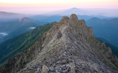
Introducing a round-trip mountain climbing video from Okuhotaka to Uma no Uma no Uta, spanning Nagano and Gifu Prefectures. This video, titled "Mt. Oku-Hotaka to Gendarmes|Route Change After a Rockslide|Video of a Detailed Round Trip of Uma no Se" (奥穂高からジャンダルム 滑落みて馬の背ピストンへ変更 馬の背詳細往復動画), was uploaded by "Biryu Jr." Mt. Oku-Hotaka Photo:The Hotaka mountain range from Mt. Norikura Mt. Oku-Hotaka is the main mountain of the Hotaka Mountain Range, which straddles Nagano and Gifu prefectures in the Hida Mountain Range of Chubu-Sangaku National Park in the southern part of Japan's Northern Alps. At 3,190 meters above sea level, it is the highest peak in the Northern Alps and the third highest in Japan after Mt. Fuji and Mt. Kita. Mt. Oku-Hotaka (奥穂高岳), Mt. Karasawa (涸沢岳), Kita-Hotaka (北穂高岳), Mae-Hotaka (前穂高岳), Nishi-Hotaka (西穂高岳), and Mt. Myojin (明神岳), are collectively referred to as Mt. Hotaka. It is said that the origin of the mountain's name comes from a legend that a god named Hotakami-no-Mikoto descended to the summit of Mt. Oku-Hotaka. Even today, the mountain is revered as a sacred mountain by local people, who visit and climb it to pray. The first person to summit Mt. Oku-Hotaka was surveyor Gunji Abe in 1906. With its challenging routes, powerful rocky ridges, and panoramic views from the ridge, Mt. Hotaka continues to attract many climbers to this day. The Geological Features of Mt. Oku-Hotaka Here, we'll take a look at the geological features of Mt. Oku-Hotaka ・Volcanic Terrain Mt. Hotaka, including Mt. Oku-Hotaka, is formed mainly of dacitic ignimbrite called "Hotaka andesite." This rock was formed by pyroclastic flows during an eruption approximately 1.75 million years ago, and was uplifted 2,000m over a period of 1 million years after a large-scale eruption. ・Glacial Landforms Many glacial landforms have been observed on Mount Hotaka. Glacial landforms are landforms created by glaciers that have accumulated soil, sand, rocks, etc., while carving away the land below. Mt. Oku-Hotaka – Uma no Se Photo:Uma no Se on Mt. Oku-Hotaka Mt. Okuhotaka, a famous mountain climbing spot, has a narrow ridge called "Uma no Se" (horse's back), which is steep and features cliffs on both sides. Because of how steep it is, it's also a dangerous place where falling accidents occur frequently. The slopes, which look like a combination of rubble, require extreme caution in order to prevent accidents. In the video, you can see how they decide not go to Gendarme (a rocky summit between Mt. Oku-Hotaka and Mt. Nishi-Hotaka), and instead decide to descend via Uma no Se. It's as realistic as if you were there yourself. The sound of the wind, the hands gripping the rocks, the shadows of climbers moving toward the spectacular views... the power of these scenes draws you in. [Video] 5:44 - Advancing Along Uma no Se Mt. Oku-Hotaka – Routes and Difficulties Here are the routes of Mt. Oku-Hotaka according to difficulty level: ・Kamikochi Course (上高地コース) - The recommended route for beginners Starting from Kamikochi Bus Center, the most common route is [Myojin (明神) - Tokusawa (徳沢) - Yoko (横尾) - Hontanibashi (本谷橋) - Karasawa (涸沢) - Mt. Hotaka Hut (穂高岳山荘, Hotakadake Sanso), Mt. Oku-Hotaka]. Your itinerary should be arranged according to your physical fitness. It is common to stay overnight during the climb. ・Kenkyakusha-Muke Course (健脚者向けコース) The rough route is [Shin Hotaka Onsen (新穂高温泉) - Shirade Hut Ruins (白出小屋跡) - Mt. Hotaka Hut (穂高岳山荘), Mt. Oku-Hotaka]. The trailhead is at Shin Hotaka Onsen. Since there are some points on the ascent where it's easy to make a mistake on the route, it's recommended that you be accompanied by an experienced climber. Furthermore, since route conditions change according to lingering snowfall, it's necessary to check trail conditions ahead of time. ・Advanced Climbing Course (熟練・上級者向けコース) The rough route is [Kamikochi Bus Terminal (上高地バスターミナル) - Yoko (横尾) - Yarisawa Lodge (槍沢ロッジ) - Kakusei Hutte (殺生ヒュッテ) - Yarigatake Hut (槍ヶ岳山荘) - Minamidake Hut (南岳小屋) - Kitahotaka Hut - Mt. Kitahotaka Hut (北穂高小屋) - Karasawa Hut (涸沢岳) - Mt. Hotaka Hut (穂高岳山荘)]. The ridge course from Yarigatake continues through rocky terrain with considerable height differences. Normally, three nights are required for this route, and extreme caution is needed as there are many steep sections. Summary of Mt. Oku-Hotaka Photo:Mt. Oku-Hotaka In this article. we introduced one of the three tallest peaks in Japan, Mt. Oku-Hotaka, and Uma no Se. Although there are dangers, such as slips and falling rocks, Mt. Oku-Hotaka is a thrilling mountaineering experience that features spectacular views of nature that attracts many climbers. Although the climb is not without its dangers, the view from the summit and the thrill of climbing over Uma no Se is said to be exceptional. If you wish to take on this challenge, please do your research and go fully prepared. That being said, if you're just here to enjoy some of the views, hopefully the video is enough for you. 【TripAdvisor】Mt. Oku-Hotaka https://www.tripadvisor.com/Attraction_Review-g298102-d7242442-Reviews-Mt_Okuhotaka-Chubu.html -
 Video article 4:44
Fukushima Oze - A Plateau Brimming With Natural Scenery! Embark on a Journey Through the Beautiful Scenery of Japan's Four Seasons!
Local PR Things to Do- 162 plays
- YouTube
About the Fukushima Oze Introductory Video This video, titled "OZE.jp Fukushima Oze PR Movie," was released by "PrefFukushima." "Fukushima Oze," introduced in the video, is the nickname for the route and area leading to Oze from the Fukushima Prefecture side. Oze National Park is a vast area of natural marshlands that spans four prefectures: Fukushima prefecture, Gunma prefecture, Niigata prefecture, and Tochigi prefecture. Oze is famous for Ozegahara, a marshland on the Gunma side, but the route that enters Oze from the Fukushima prefecture side is called Fukushima Oze, and it has also been gaining popularity as a sightseeing route full of natural scenery. In this video, you can see two women trekking the mountain while traveling around Fukushima Oze. Hiking at Fukushima Oze Photo:Lake Ozenuma, Fukushima Prefecture Walking along the promenade of Fukushima Oze Route, you can enjoy the natural scenery of Japan's four seasons. Take a shuttle bus to Numayama Pass, the starting point of the Oze Route, and then proceed to the Oe Marsh, which can be seen from 1:15 in the video. You'll also find seasonal alpine plants, such as skunk cabbage and day lilies, blooming in the Oze Highlands and around Lake Ozenuma in the spring, creating a magnificent view, as shown at 0:51 in the video. Sightseeing Locations at Fukushima Oze Photo:Ozegahara seen from Hiuchigatake, Fukushima Prefecture There is a fishing pond full of char in Hinoemata, a village where you can enjoy fishing surrounded by nature. We definitely recommend stopping by Sanjo Falls, one of the Top 100 Waterfalls in Japan. In Oze, be sure to drop by famous places, such as Hashiba no Banba and Seirou-zukuri Itakura (セイロウ造り板倉), a famous place in Nushiri-daira. Hinoemata Shrine also has a stage where you can see traditional Hinoemata Kabuki. The area around Hiuchigatake, one of the 100 Famous Japanese Mountains, that can be seen from 1:34 in the video, is another recommended sightseeing route. Visit the summit of Hiuchigatake from Lake Miike via Hirosawa Tashiro and Kumazawa Tashiro. After sightseeing in Oze, you can head over to Hiuchi no Yu (燧の湯), a hot spring at the foot of Mt. Hiuchigatake. There is also an open-air outdoors bath, so you can spend an excellent time bathing while gazing at the vast nature. Events and Gourmet Food in Oze Photo:Shrine at Mini Oze Park, Fukushima Prefecture The "Fukushima Oze-Hinoemata Mountain Festival" is held every year at Fukushima Oze. There are hiking tours, outdoor events, stage shows and workshops, and markets where you can shop for outdoor goods, so we recommend lining up your trip to visit Fukushima Oze at the time of this event. If you're looking to enjoy delicious food in Oze, we recommend Aizu's famous mountain dish, "Tachi-soba." At Mini Oze Park, you can buy a mysterious dessert called "salamander gelato" (サンショウウオジェラート). Summary of Fukushima Oze Photo:Fukushima Oze, Fukushima Prefecture Oze, with its abundance of nature, is closed in the winter due to the cold weather, but is a great tourist attraction for hiking in the warmer months. In addition to beautiful natural spots like the ones shown in the video, there are also spots where you can enjoy traditional performing arts and local cuisine, so be sure to check it out! -
Video article 0:59
Ogita Yasunaga - The First Japanese Person to Reach the South Pole Alone Without Receiving Any Supplies!
News Celebrities- 52 plays
- YouTube
Japanese Adventurer Ogita Yasunaga! This video, titled "'The Earth is Huge!' Mr. Ogita, who walked to the South Pole" (「地球って大きいな」歩いて南極点に立った荻田さん), was created by "ANNnewsCH." It's a news broadcast about Japanese adventurer, Ogita Yasunaga, who reached the South Pole solo, with no resupply aid. He walked 1,130 kilometers across the Antarctic continent by himself, being the first Japanese person to best the journey without aid. After achieving the feat, he says in the interview "The earth is huge." This can be seen at 0:10 in the video. About Ogita Yasunaga Source :YouTube screenshot Japanese adventurer Ogita Yasunaga is from Hokkaido, Japan. He has walked the Canadian Arctic, Greenland, and Hokkaido alone. From 2000 to 2019, he went to the North Pole a whopping 16 times! In April 2019, he traveled 600 kilometres in the Arctic Circle with young travelers. He is noted as Japan's only Arctic adventurer and gives various lectures and talk events. In 2000, he participated in "Adventure Walk aiming for North Magnetic Poles," a 700 km walk from Resolute to the North Pole. In 2003, he walked to Victoria Island in the Canadian Arctic Circle, and in 2004, he went on a dog sledding trip in Greenland. In 2011, he received the Faust A.G. Award for Adventurer of the Year and in 2017, he received the Naomi Uemura Adventure Award. He appeared in "Crazy Journey" on TBS, "News Watch 9" from NHK and WOWOW's "Nonfiction W." When he appeared in Crazy Journey, Matsumoto Hitoshi, the host of the show, was amazed by his feats and the episode was well received by audiences. The DVD is available on Amazon, so check it out if you're interested! The First Japanese Person to Reach the South Pole Unassisted Source :YouTube screenshot As you can see in the video, he was the first Japanese person to reach the South Pole unassisted. He left the coast of Antarctica in November 2017 and pulled a 100 kg sled loaded with food and other supplies, and skied roughly 1,130 km in 50 days. He reached the South Pole as planned, despite being faced with difficult conditions, including strong headwinds and snowfall. You can see Ogita Yasunaga posing with his fist in the air after reaching the South Pole at 0:17 in the video. During the Journey, his daily diet was 1 kg of food/day, roughly 5000 kilocalories. He had oatmeal for breakfast, biscuits, nuts, and chocolate bars for lunch and instant rice for dinner. He was able to survive and complete his journey by eating foods high in calories. At the end of the video he introduces his next goal. To make it to the North Pole unassisted! Summary of Ogita Yasunaga Photo:Base in Antarctica The video introduces Ogita Yasunaga the Japanese adventurer who reached the South Pole completely unassisted. His achievement was widely covered by the media. If you want to learn more about the awesome Japanese adventurer Ogita Yasunaga, be sure to check out his official website and Instagram! 【Official Website】Ogita Yasunaga https://www.ogita-exp.com/english/ -
Video article 4:48
Mountaineer Ken Noguchi Talks About Environmental Issues. The Climber Who Conquered the Mountains of the World, Now Spends His Time Cleaning up the World Heritage Site Mt. Fuji, With Children.
Celebrities Nature- 209 plays
- YouTube
The Cool Choice Project The Cool Choice Project is an educational activity that was launched in 2015 to introduce the efforts of the Ministry of the Environment to tackle global warming and call on all people to help fight global warming caused by carbon dioxide. Ken Noguchi, a world-famous, professional mountaineer, and the youngest person to climb the Seven Summits, talks about COOL CHOICE in a video interview titled "Our COOL CHOICE: Mountaineer Ken Noguchi|COOL CHOICE" (私たちができるCOOL CHOICE 登山家 野口健|COOL CHOICE). Who Is Ken Noguchi? Source :YouTube screenshot Maybe the profile of the alpinist (professional mountaineer) Ken Noguchi is more appropriate than the mountaineer Ken Noguchi. Mountaineer Ken Noguchi- No, scratch that, PROFESSIONAL mountaineer Ken Noguchi, was born in Boston, Massachusetts, to a Japanese diplomat father and an Egyptian mother. He first came to Japan when he was four years old, and at first, wasn't able to speak any Japanese. His parents also divorced when he was in elementary school. When he was suspended from high school, he received a copy of "Risking My Youth on the Mountains" by mountaineer Naomi Uemura and had his first mountain climbing experience. Even when he was unsure of what to do after graduating from high school, this book inspired him to enroll in Asia University with the goal of conquering the Seven Summits. Ken Noguchi is currently married, with a wife and daughter. It became a hot topic on a TV variety show when it was revealed that he and his wife had lived apart for 15 of their 16 years of marriage and that he had set up a separate house in Otsuki, Yamanashi Prefecture, far from his home, and that even when he was in Japan, he stayed there. His daughter, Eko Noguchi, is a TV personality and mountaineer that does mountain climbing activities with her father. You can find more information about Ken Noguchi and his daughter on Twitter and blog, so if you're interested, be sure to follow him. Source :YouTube screenshot Ken Noguchi Profile ・ Height 169 cm (5'6") ・ Blood type A ・ Alpinist (professional mountaineer) and t.v. personality ・ Visiting Scholar, Asia University -Biography- ・ Climbed Mont Blanc, the highest peak in the European continent, at the age of 16. ・ At the age of 17, climbed Mt. Kilimanjaro, the highest peak on the African continent. ・Set the record for the youngest person to climb Mt. Everest at the age of 25. ・ Established the Sherpa Fund for Sherpa orphans who died in 2000 ・ Established the Manaslu Fund in 2006 to support children's education in Sama Village ・ Currently engaged in cleaning and climbing the Himalayas and Mt. Fuji as a representative of NPO PEAK + AID Environmental Protection Message From Mountaineer Ken Noguchi Source :YouTube screenshot At 1:00 in the video, Noguchi talks about his reasons for wanting to clean up the environment. A truly admirable task. When climbing Everest for the first time, he noticed there was a lot of garbage, some of which had Japanese writing on it. According to the Sherpas, Mt. Fuji is famous for being one of the most trash-filled mountains in the world, and the Japanese climbers are considered a nuisance because they just kept littering. Hearing this, Noguchi's ego as an alpinist began to change. From 2:38 in the video, Noguchi says, "Above all, it's important to understand our impact on nature." Without mountains, there'd be no mountaineering. Understanding this, Noguchi desired to keep clean the mountains that he treasured so. If you love the sea, you clean the sea. The first thing to do is to discover a connection with nature, even if it's subjective, just wanting to clean the place that you love, that's a start. Summary of Professional Climber Ken Noguchi Source :YouTube screenshot In addition to his work as a mountaineer, Ken Noguchi also focuses on environmental education and organizes classes to clean up mountains around Japan, including Mount Fuji. You can see some of his activities at 2:44 in the video. We hope you take a look at Mr. Noguchi's interview and think about your own impact on the environment. 【Official Website】Ken Noguchi Official Website http://www.noguchi-ken.com/ -
Video article 3:32
Mt. Odaigahara – Hiking the Beautiful Mountain in Nara, Japan
Nature Travel- 165 plays
- YouTube
A Paradise of Precious Plants, Mt. Odaigahara, Nara: Video Introduction Photo:Autumn at Mt. Odaigahara, Nara Prefecture This video, titled "[Official] Higashi Odaigahara, Kamikitayama, Nara|Promotional Video (Short Ver.)" (【公式】奈良県上北山村・東大台ヶ原(HIGASHI ODAIGAHARA)プロモーション映像(短編)), was uploaded by "kamikitayama." Mt. Odaigahara is one of the 100 Famous Japanese Mountains and the entire mountain is designated as Yoshino-Kumano National Park. It's divided into Higashi-Odaigahara, which anyone can visit, and Nishi-Odaigahara, which requires advance permission to enter in order to protect the natural environment. Enjoy the beauty of Higashi-Odaigahara, a charming place for hiking, mountain climbing, and even just a walk, in the video below. Higashi-Odaigahara – A Popular Hiking and Trekking Spot With Beginner Courses Photo:A suspension bridge at Mt. Odaigahara, Nara Prefecture Mt. Odaigahara is a sightseeing spot selected as one of the 100 Famous Japanese Mountains and 100 Unexplored Regions of Japan. The mountain is located in Kamikitayama, Nara, in Japan's Kansai region. Mt. Odaigahara is popular among climbers and hikers because of its unrestricted access. Mt. Odaigahara has four trekking trails that can be climbed and hiked, ranging from beginner to advanced courses. The A trail (middle trail) for beginners starts from the Mt. Odaigahara parking lot and passes Hinodegatake, Masakigahara, Owashi Tsuji, Ushiigahara, Ojigura, and Owashi Tsuji before returning to the parking lot again. From the observatory on Mt. Hinodegatake, you can enjoy a panoramic view of the Omine Mountain Range and other mountains, and if the weather is nice early in the morning, you may even be able to see Mt. Fuji. As the name "Hinodegatake" (lit. "Sunrise Mountain") suggests, the summit is known as a sunrise viewing spot where visitors can watch the sunrise from the top of the mountain. Masaki Pass, located just before Masakigahara, offers a mysterious view of dead and fallen trees on a wide hill, and a spectacular view of the Kumano-nada Sea beyond. Masakigahara is a vast grassy area with trees and a view of Masaki Pass in front of it, where wild deer are frequently seen. The highlight of the beginner course in Higashi-Odaigahara is Daijagura, an 800-meter precipice that offers visitors a panoramic view of the Omine Mountains. Trail A for beginners is about 9 km long and takes about 4 hours to complete. Trail B, for intermediate-level climbers, is the same as Trail A with the addition of Shiokara Valley. This popular course has a slope called "Shakunage Slope" (Rhododendron Slope) where rhododendrons bloom for about a week every year from May 20, leading up to Shiokara Valley. Shiokara Valley has a suspension bridge, and visitors can also enjoy a walk along it downstream. Nishi-Odaigahara, a Treasure Trove of Nature That Requires a Permit to Enter Photo:The outdoors of Nishi-Odaigahara Mt. Odaigahara can be divided into two main areas. One is the Higashi-Odaigahara area, where anyone can enjoy climbing and hiking, and the other is the Nishi-Odaigahara area, where advance permission is required to enter the mountain. The Nishi-Odaigahara area is designated as a special protection area to preserve the natural environment, and the number of people entering the mountain is restricted. Nishi Odaigahara receives approximately 5,000 millimeters of annual rainfall, as much as that of Yakushima Island, and features virgin forests nurtured by the rain, allowing visitors to enjoy the landscape with its pristine vegetation. Wildlife and the Four Seasons on Mt. Odaigahara Photo:The Milky Way from Mt. Odaigahara, Nara Prefecture Mt. Odaigahara is home to a large number of wild animals. In addition to the deer of Masakigahara, there are Japanese serows, foxes, tanuki (Japanese raccoon dogs), marten, and Japanese squirrels, as well as many wild birds, such as Eurasian jays and wrens, and great spotted woodpeckers. Mt. Odaigahara is also a popular photo spot because of its lush greenery, seas of clouds, and beautiful starry skies. If you're looking to take some Instagram photos, this is definitely a place to visit! In autumn, you can see the leaves turned beautiful shades of red and orange, and in the cold winter months, if you're lucky, you can see the local flora covered in rime. A Hiking Trip for Advanced Hikers Photo:Dogura Falls, Osugidani Valley, Mie Prefecture For advanced hikers looking for an adventure to discover the beauty that is Japan's nature, there's a course that will take you on a 10-mile hike from Osugidani Valley, an idyllic place of interest, to the breathtaking Mt. Odaigahara. This hike will take even the most advanced hikers at least 2 days to complete due to the terrain, but if you're up to the challenge and have the experience, it's well worth your time. During the hike, you'll pass Dogura Falls (堂倉滝), a waterfall with a 20-meter drop and a beautiful basin where you can relax and take a break while hiking, Nanatsugama Falls (七ツ釜滝), a unique, 7-tiered waterfall, and Shishi-buchi (シシ淵), a breathtaking canyon with a waterfall hidden at the back of sheer cliffs, and a myriad of other points of interest. As the hike will take 2-3 days to complete, you'll need to stay overnight at the rest stop Momonoki Yamanoie (桃の木山の家). The Ohsugidani Tozan Center has maps with detailed courses as well (including this one and other shorter tours), which we highly recommend checking out. ※For information on reservations, routes, and hiking conditions/seasons, please contact the Ohsugidani Tozan Center (大杉谷登山センター). ※Camping and campfires are strictly prohibited in the Mt. Odaigahara and Osugidani Valley area. ※Because weather in the area can change quickly, it's necessary to bring sufficient equipment for rainy conditions. ※If you have any doubts in your hiking abilities or you are unable to acquire the necessary information for a safe hike, we strongly suggest waiting until you are fully prepared. ※It's recommended that you bring a helmet, as there is a danger of falling rocks along the hiking trail. Summary of Mt. Odaigahara, Nara Photo:Osugidani Valley, Mt. Odaigahara, Nara Prefecture Mt. Odaigahara is also a registered UNESCO Eco Park, and efforts are also being made to promote symbiosis between nature and people. When visiting Mt. Odaigahara, it's recommended that you use public transportation. If you take a bus departing from Yamato-Kamiichi Station, you can reach Mt. Odaigahara in about 2 hours. If you're driving, please note that the parking lot may be full during high seasons, such as autumn, when the leaves change color. Mt. Odaigahara, also known as the "Roof of the Kinki Region," is also famous as a summer retreat. A walking map of Higashi-Odaigahara is available for climbers and hikers as well. If you're looking to explore the beautiful outdoors of Japan, then consider a trip to Mt. Odaigahara. 【TripAdvisor】Mt. Odaigahara -
Video article 6:26
Video of the autumn foliage of Mt. Takao in Hachioji, Tokyo! A tourist spot listed in the Michelin Guide.Enjoy beautiful autumn by hiking and climbing!
Nature Travel Things to Do- 211 plays
- YouTube
Autumn Leaves on Mt. Takao: Video Introduction This video, titled "Autumn Leaves and Hiking on Mt. Takao|Travel|Sightseeing in Tokyo|Michelin Guide|Autumn Leaves in Japan|4K 2021" (4K 2021紅葉の秋の高尾山 TOKYO Autumn leaves of Mt. Takao 紅葉ハイキング 高尾山観光 旅行 Michelin Guides 東京観光 日本の紅葉 紅葉の名所), was uploaded by "Discover Nippon." Mt. Takao, a 599-meter-tall mountain in Hachioji, Tokyo, in Japan's Kanto region, is a national park that has received three stars in the Michelin Guide and is a tourist attraction where visitors can enjoy hiking. Mt. Fuji can be seen from the top of the mountain, and Takao Yakuoin Temple is crowded with many visitors. [Video] 1:55 - Takao Yakuoin Temple Be sure to check out the video to see the autumn leaves of Mt. Takao Hiking and Mountain Climbing – Recreational Activities on Mt. Takao Photo:Autumn leaves on Mt. Takao, Hachioji, Tokyo Mt. Takao, located in Hachioji, Tokyo, is 599 meters above sea level. As a relatively easy-to-climb low-lying mountain, it's gaining popularity as a mountain where hikers and climbers can enjoy casual hiking and mountain climbing. There are both full-scale mountain climbing courses and hiking courses that can be completed in casual clothing, making the mountain enjoyable for adults and children alike. From the observatory at the top of the mountain, visitors can view the symbol of Japan, Mt. Fuji. Mt. Takao is also home to legends of tengu, Japanese goblins, that have been passed down for generations. Takao Yakuoin Temple, a Shingon sect temple located halfway up Mt. Takao, is said to bring good luck and ward off evil spirits. The main deity, Izuna Daigongen, a deity worshipped by Japanese warlords during the Warring States Period, is said to be accompanied by a tengu, and you can see statues of tengu in many places on Mt. Takao. [Video] 2:00 - Takao Yakuoin Temple Mt. Takao is also famous for its autumn leaves, which attract many tourists in the fall. Even though the mountain is not very tall, the temperature is lower than that of the ground, so be sure to dress warm when visiting. When to View the Autumn Leaves on Mt. Takao Photo:The cable car on Mt. Takao, Hachioji, Tokyo Mt. Takao's annual autumn leaves are at their best from mid-November to early December. The best places to view the autumn leaves on Mt. Takao are around Takao-yamaguchi Station, in front of Kiyotaki Station on the cable car, and halfway up the mountain on the cable car. In addition, a festival to celebrate the autumn leaves is held every year from early November to coincide with the autumn foliage of Mt. Takao. On holidays, various events, such as demonstrations of Tokyo Kokeshi doll-making and masu-zake (sake served in small boxes) enliven the celebration of the autumn leaves. Be sure to check event schedules in advance, as they are subject to change. Advanced Hiking Courses and Crowding Information on Mt. Takao Photo:Autumn leaves on Mt. Takao, Hachioji, Tokyo As Mt. Takao can be climbed by cable car or lift to the midpoint of the mountain, it attracts many visitors. It's said to be the most visited mountain in the world, with 3 million climbers per year. During the high season, particularly during the fall when hikers can view the autumn leaves, it's not unusual for visitors to have to wait up to an hour for the cable car. If you're planning on climbing or hiking Mt. Takao, we recommend checking the latest information regarding crowding conditions on social networking sites before visiting the mountain. If you want to see the autumn leaves in a relaxed atmosphere, we recommend arriving at the mountain early in the morning. The cable cars start running at 8:00 a.m., and there are fewer people on the mountain first thing in the morning, making this the best time to arrive. If you're a beginner, Mt. Takao can be ascended in about an hour by cable car, but there is also a course that can be enjoyed by advanced climbers. However, there is also a trail that advanced climbers can enjoy. This is the advanced course located at the branch leading to the southern trails 2 and 6. Compared to the gently paved beginners' trails, this trail is not paved and climbs along a mountain path that's too slippery for ordinary sports shoes. Therefore, trekking shoes or other mountaineering shoes are required for this trail. It's the most mountain trail-like course on Mt. Takao. Mt. Takao is truly a mountain that can be enjoyed by both beginners and advanced climbers alike, so if you're a nature lover, or just looking to enjoy some wonderful scenery, consider going for a hike up the mountain while appreciating the autumn leaves. Summary of Autumn Leaves and Sightseeing on Mt. Takao We've introduced Mt. Takao during the fall foliage season, but you can also enjoy Mt. Takao lit up in the summer. At Takao Yakuoin Temple, the statues at Niomon gate and the bronze statues of tengu are lit up with green and red lights. The nighttime scenery is completely different from that of the daytime, and will have you feeling as though you're in a scene from some mythological story. Mt. Takao, a famous place for viewing the autumn leaves, can be reached in about an hour by train from Shinjuku Station in central Tokyo. There are parking lots in the area, but expect crowds during the fall when people come to view the autumn leaves. Be sure to check information in advance before visiting the mountain as well. Mt. Takao is a great spot for climbing and hiking to view the autumn foliage. It'd be a shame to miss such beautiful scenery! 【TripAdvisor】Mt. Takao https://www.tripadvisor.jp/Attraction_Review-g1060898-d320052-Reviews-Mt_Takao-Hachioji_Tokyo_Prefecture_Kanto.html -
Video article 0:53
Mt. Norikura: At an Altitude of Nearly 10,000 Feet, Boasting 60-Foot-Tall Snow Walls and Autumnal Leaves, Its a Great Place to Enjoy Nature in Every Season in Nagano and Gifu Prefectures!
Nature Travel- 226 plays
- Vimeo
Norikura-dake" in Nagano and Gifu Prefectures, Introduction of mountain climbing video This video, titled “Mt. Norikura in one minute” (乗鞍岳登山を一分でまとめてみました。), was created by “odenkuuuuuuun.” It introduces Mt. Norikura, a part of the Hida Mountains, or Northern Alps. Mt. Norikura is one of "Japan’s Top 100 Famous Mountains," and stretches through Nagano Prefecture’s Matsumoto City to Gifu Prefecture’s Takayama City. The video summarizes "odenkuuuuuuun's" climb of Mt. Norikura in September. Although the video is only 54 seconds long, it’s brimming with the allure of Mt. Norikura. Matsumoto Prefecture・Gifu Prefecture’s Mt. Norikura Photo:Summit of Mt. Norikura Mt. Norikura is a complex volcano encompassing 7 lakes and 8 plains. The highest of its 23 peaks is Kengamine Peak, at a height of 10,000 feet. The mountain was chosen as one of "Japan’s Top 100 Famous Mountains," and its popularity extends to foreign visitors as well. Its most recent eruption is said to be the Mt. Ebisu eruption over 2000 years ago. The mountain lies in the Hida Mountains. At the top of the mountain is the Norikura Shrine (乗鞍神宮, Norikura jingu), which has been a place of worship since long ago. This can be seen from 0:47 in the video. In the Shinshu Province, the mountain is also known as “Asahidake,” due to it being the first mountain touched by the light of the morning sun. (朝日, Asahi "Morning sun," 岳, dake "Mountain/Peak"). The starting point of the trail is Tatami-daira, which is 8,800 feet above sea level, and it takes about 1.5 hours to reach the summit, depending on which trail you take, making it an easy climb even for beginners. However, at an altitude of 10,000 feet, the weather can be quite unpredictable, and the temperature is low year round, so you'll need to wear warm clothes. Mt. Norikura’s popular trekking courses include the route from Tatamidaira to Kodamadake to Kengamine (approximately one and a half hours), and the route from the Norikura Kogen highlands to the peak of Mt. Norikura (approximately five hours and forty minutes). There are hiking courses available as well. Behind Tatamidaira is a national park where alpine flora and fauna are blooming, and visitors can enjoy the beautiful sight of the flower gardens while strolling around the lake or through the promenade. Autumn at Mt. Norikura provides stunning views of autumn leaves. The peak viewing period is from mid-September to early October. During the summer season, July to September, buses begin operating early in the morning, enabling visitors to be able to enjoy the sunrise from the 10,000 ft. tall mountain peak. It's great for taking pictures. Be sure to post them on your Instagram! On Mt. Norikura, there are a few mountain huts, so climbs with overnight stays are also possible. Many of these huts are fully-equipped with facilities such as baths, so visitors can feel as if they're resting at a hotel or ryokan. For the sake of nature preservation, access to Mt. Norikura by personal vehicles is limited, so you will need to use a tourist bus, shuttle bus, or taxi to get there. As the entrance of private cars is prohibited, of course, the usage of the Tsurugaike Parking Lot is not permitted. Visitors can head to Mt. Norikura from the Honokidaira Bus Terminal or the Hirayu Onsen Bus Terminal. The bus terminals can be found at Hirayu Onsen of the Okuhida Onsen Village. Roads leading to Mt. Norikura include the Norikura Skyline (乗鞍スカイライン, Norikura sukairain) from Gifu Prefecture, as well as the Norikura Eco Line from Nagano Prefecture. Travelling on road bikes or bicycles is also possible. Cycling events are held as well, such as the “Mountain Cycling in Norikura,” and the “Norikura Skyline・Cycling Hill Climb. Sightseeing Around Mt. Norikura Photo:Mt. Norikura Snow Wall Norikura Kogen highland’s Norikura Skyline is open from mid-May to mid-June, visitors can view the snow wall "Yuki no Kairo" (雪の回廊, yuki no kairo) as well. At its highest, the snow wall can reach up to 60 feet, towering over the Norikura Skyline. Visitors can even walk amongst this magnificent sight. As seen from 0:17, snow remains on Mt. Norikura even in September, and summer skiing, where visitors climb the mountain on their own and ski at the peak, is also possible. Of course, in winter, ski resorts are opened as well, and visitors can enjoy winter sports such as skiing and snowboarding. Mt. Norikura also boasts the 50-meter “Sanbon Falls (三本滝, Sanbon-daki), which is counted among "Japan’s top 100 waterfalls." It has been a place of worship since olden times, and it is said that ascetics come to practice discipline at this waterfall. The “Starry Sky Observation Event” at Tatamidaira is also popular. Visitors can gaze up at the night sky full of stars while listening to the guide’s explanation of the sights. Summary of Mt. Norikura What'd you think of this article about Mt. Norikura? From the video, you can see the mountain from the view of a mountain climber, but you don't need to be a mountain climber to enjoy the natural beauty of Mt. Norikura. Although only 54 seconds long, the video is full of the sights and sounds of Mt. Norikura, so definitely check it out! 【Official Website】Mt. Norikura, Norikura Skyline Official Site https://norikuradake.jp/en.html 【Tripadvisor】Mt. Norikura https://www.tripadvisor.com/Attraction_Review-g298102-d2318270-Reviews-Mt_Norikura-Chubu.html -
Video article 11:19
Enjoy a Cup of Pure Bliss in the Great Outdoors! Enjoy an Out-of-the-Ordinary Experience With Coffee Brewed From the Spring Water of Oike Spring in Oita Prefecture
Nature- 35 plays
- YouTube
This video, titled "[Hiking] Coffee From a Spring - A Walk in the Woods and a Quiet Time" (【ハイキング】湧き水でコーヒー - 森林散策と静かな時間), was released by "Morinone Channel" (モリノネチャンネル). Wouldn't it be wonderful to make coffee from a clean spring in the mountains and take in the magnificent scenery? The Oike Spring Group in Yufu City, Oita Prefecture, introduced in the video, is an area at the source of the Aso River. The rainfall on Mt. Kurodake is filtered underground over a long period of time to produce clean spring water. It's very comfortable and cool even in summer as it is located 850 meters above sea level. Sitting under a tree, boiling water from the spring with a portable stove, and drinking coffee will refresh your body and mind. -
Video article 6:37
4K video of silver grass at "Sengokuhara Miscanthus Meadow" in Ashigarashimo-gun, Kanagawa Prefecture! Don't miss it in autumn when it is at its best! Also introduces nearby spots, lunch, etc.
Nature Travel- 209 plays
- YouTube
Video introduction of "Sengokuhara Susuki Meadow" in Ashigarashimo-gun, Kanagawa Prefecture This video, titled "Sengokuhara Pampas Grass Field - Kanagawa - 4K Ultra HD" (Sengokuhara Pampas Grass Field - Kanagawa - 仙石原すすき草原 - 4K Ultra HD), was uploaded by "TokyoStreetView - Japan The Beautiful." Enjoy the beautiful 4K visuals and the sound of pampas grass swaying in the wind as if you were standing in the pampas grass field of Sengokuhara. Sengokuhara – A Famous Place for Viewing Pampas Grass in Hakone, Kanagawa Photo:The pampas grass field of Sengokuhara, Hakone The pampas grass field of Sengokuhara is located on Mt. Hakone in Kanagawa Prefecture, in Japan's Kanto region. It is one of the "Top 50 Scenic Spots in Kanagawa" and "Top 100 Places to View Flowers in Kanagawa," and is well known for its pampas grass. At the foot of Mt. Daigatake, which was formed by the eruption of Mt. Hakone, lies a field of pampas grass, and in autumn, visitors can enjoy the beautiful scenery of golden plumes rippling in the wind. The fantastic scenery of the Sengokuhara pampas grass field has attracted a lot of attention and draws a large number of tourists every year. The Field of Pampas Grass in Hakone – When to See the Breathtaking Autumnal Scenery Photo:The walking path through the pampas grass field of Sengokuhara, Hakone The golden pampas grass in the field in Sengokuhara is at its best from late September to early November. The lush green tips of pampas grass turn a silvery-white, and as autumn deepens, the tips open up and turn a pale golden color. The beautiful golden color of the pampas grass field, which can only be seen during autumn in Japan, is a distinctive sight of autumn in Hakone. The main walking route for the pampas grass field is to go straight along the path and back, which takes about 30 minutes round-trip. The path through the grassy field is great for taking photos as well. [Video] 0:05 - Sengokuhara Pampas Grass Field Walking Path At the midpoint of the path, visitors can enjoy a lovely collaboration of mountains and the soft tips of the pampas grass. The view from the small hill in the middle of the path is another nice spot, perfect for taking pictures. The best times to visit are in the morning and at dusk, when there are few people around. The photogenic golden pampas grass glistening in the sunlight and the setting sun are guaranteed to be make for awesome photos for Instagrammers and photographers alike. The Pampas Grass Field of Sengokuhara During Summer Sengokuhara's pampas grass field is of course famous for its pampas grass in autumn, but other seasons also have their own unique charms. In early summer, around June, visitors can enjoy the lush green landscape of the meadow that has grown back after the annual burn in the spring. The sight of the newly sprouted green pampas grass swaying in the wind is a different aesthetic than that of autumn. The green pampas grass and blue skies are a perfect contrast, and photographers/Instagrammers can take some delightful photos during this time as well. Spring at Sengokuhara – A Fiery Event on the Pampas Grass Field In the pampas grass field of Sengokuhara, an event called Yamayaki is held from mid to late March every year. Yamayaki, meaning "Mountain burning," is an annual event to maintain the pampas grass field. By burning the dead grass, it prevents the growth of weeds in the field and helps to return the meadow to its youthful appearance. The event is held in the mild spring weather, and spectator seating is available as well. The crackling fire and the intense heat are definitely worth a trip to Hakone. How to Get to Sengokuhara's Pampas Grass Field + Parking & Lunch Photo:Hakone-Yumoto Station To get to Sengokuhara's pampas grass field, take the Hakone Tozan Bus bound for Togendai from Hakone-Yumoto Station and get off at Sengokogen (~30 mins). If going by car, free parking and paid parking are available in the immediate vicinity of the pampas grass field. A temporary free parking lot is also available from September 1 to November 30 every year during the pampas grass' peak viewing period. For lunch, we recommend trying the soba restaurant Hoshinoan (そば処 穂し乃庵, Soba-dokoro Hoshinoan) by the Sengokuhara pampas grass field. In the midst of the refreshing pampas grass field, you can enjoy the seasonal flavors and unique dishes made from the best ingredients while gazing out at the field of pampas grass. Summary of Sengokuhara's Pampas Grass Field The area around the Sengokuhara pampas grass field is home to numerous tourist attractions, including art museums, and its hot springs, characterized by their cloudy white water, are also popular. In particular, the hot springs of the Hakone Ichinoyu Group, which currently has 10 facilities in Hakone, are well known as affordable accommodations in Hakone, and feature dreamy open-air guest rooms as well. Let the warmth of the hot springs wash away your fatigue. Sengokuhara's pampas grass field is easily accessible from central Tokyo, as it's located just a short 2-hour and 15-minute bus ride from Shinjuku Station in Tokyo via the Odakyu Hakone Express Bus. If taking this route, be sure to get off at the Sengokukogen bus stop. Enjoy a visit to see the spectacular golden landscapes of autumn in Hakone! 【TripAdvisor】Sengokuhara https://www.tripadvisor.com/Attraction_Review-g298171-d1514732-Reviews-Sengokuhara-Hakone_machi_Ashigarashimo_gun_Kanagawa_Prefecture_Kanto.html -
Video article 2:09
Otaru Tenguyama in Otaru City, Hokkaido! Video introduction of the ropeway, view from the observatory, shrine, and other attractions! How to enjoy and Otaru night view spots too!
Travel Nature Food & Drink- 325 plays
- YouTube
Mt. Tengu in Otaru, Hokkaido: Video Introduction This video, titled "Otaru Tenguyama (Mt. Tengu) - Enjoy a Spectacular View of the Sky|Official PR Video" (札幌から一番近い 天空の絶景を存分に楽しめる小樽天狗山 -Mt.TENGU-|公式PR動画), was uploaded by Otaru Tenguyama Ropeway. The video introduces various things to do on Otaru Tenguyama (Mt. Tengu), including a ropeway, beautiful views from the observation deck, a shrine and cafeteria at the top of Tenguyama, and more. There's no shortage of fun things to do on Mt. Tengu. What is Otaru Tenguyama? Photo:The view from Otaru Tenguyama, Hokkaido Otaru Tenguyama, aka Mt. Tengu, is a 532.4-meter-tall mountain located in Otaru, Hokkaido. It is a symbolic mountain of Otaru and overlooks the city of Otaru and the Sea of Japan. Otaru Tenguyama is approximately 15 minutes from the Otaru IC by car, and 17 minutes by bus from JR Otaru Station. You can also drive to the top of Mt. Tengu, but we recommend taking the ropeway if it's your first time visiting the mountain; the 30-seat ropeway takes roughly 4 minutes to reach the top, and offers a spectacular view of Otaru Bay, Ishikari Bay, and even the Shakotan Peninsula on a clear day. In the winter, you can enjoy skiing at a ski resort where two lifts are in operation. In the warmer months, there are zip lines, hot air balloon rides, mountain climbing/hiking, slides, and camping facilities that are popular during summer vacation. Otaru Tenguyama is an appealing tourist attraction that can be enjoyed all year round. Otaru Tenguyama (Mt. Tengu) – Observation Deck, Shrine, and Gorgeous Night Views Photo:Tenguu Terrace, Otaru Tenguyama, Hokkaido Here, we'll take a look at some things to do on Otaru Tenguyama. ・Observation Deck Otaru Tenguyama has five observation decks with different views. Tenguu Terrace, located at the Tengu Cherry Blossom Observatory, offers an unobstructed view from a wooden deck with no railing. Some visitors take pictures with their takeout drinks they ordered from the nearby TENGUU Café! [Video] 0:19 - Tenguu Terrace ・Mt. Tengu Shrine Mt. Tengu Shrine, located at the top of Mt. Tengu in Otaru, Hokkaido, is dedicated to the deity Sarutahiko. Located near the shrine is a large tengu, which is said to ward off evil and make wishes come true when its long nose is stroked. [Video] 0:37 - Mt. Tengu Shrine ・Night Views Otaru Tenguyama is also known for having one of the three best night views in Hokkaido. In addition to the Tenguu Terrace observation deck, the Manten Stage offers a night view of the highway and a starry sky. [Video] 1:55 - The Night View from Otaru Tenguyama Photo:Chipmunk Park, Otaru Tenguyama, Hokkaido ・Chipmunk Park Chipmunk Park is a park where you can see cute chipmunks up close and feed them. (The park is open from late May to mid-October.) [Video] 0:33 - Cute Squirrels at Chipmunk Park Winter at Otaru Tenguyama – Skiing & Fireworks One of the best things to do during winter at Otaru Tengu is enjoy some winter sports on the ski slopes, which offer a spectacular view of the area. Skiing while enjoying the view below is a great way to unwind and have some fun. Otaru Yuki Hanabi (Otaru Snow Fireworks) is a fireworks display held at the ski resort in December, and is a popular annual event. The 2022 Otaru Snow Fireworks was held on December 17, but the schedule for 2023 has yet to be determined. Please check the Otaru Yuki Hanabi official website for information regarding the 2023 event. Otaru Tenguyama – One of the Top 3 Nights Views of Hokkaido + Nearby Night Views Photo:The night view from Mt. Hakodate, Hokkaido Otaru Tenguyama is one of the top 3 night views of Hokkaido, along with Mt. Hakodate and Mt. Moiwa, but there are other lesser-known night view spots scattered around the area. Some recommended night view spots are the Asahi Observatory, which can be easily accessed via a 5-minute drive from Otaru Station; the Mount Kenashi View Point, a 30-minute drive from Otaru Station; and the illumination of the Otaru Canal, a famous tourist attraction in Otaru, Hokkaido. After enjoying the night view of Mt. Tengu, consider visiting one of these other locations. Other Things to Do in Otaru, Hokkaido Besides Otaru Tenguyama, there is a myriad of things to do in Otaru. Otaru Museum A museum offering a variety of activities with which to learn about the history and natural scenery of Otaru, Hokkaido. The museum is made up of two facilities: the main museum and the canal museum. The museums are located just 20 minutes apart and so its recommended that you visit both as there are also discounted tickets that can be used at both facilities. Hours: 9:30 am - 5:00 pm Admission Fee: General admission: 400 yen (winter 300 yen), high school students and senior citizens living in the area: 200 yen (winter 150 yen), Junior high school students and younger: free Otaru Aquarium Built in 1958, the Otaru Aquarium has a variety of exhibits, including penguins, dolphins, sea lions, etc. Children and adults alike can enjoy learning about the various marine life at the aquarium and even watch the impressive dolphin shows. The aquarium shop features a variety of cute stuffed animals and souvenirs to commemorate your trip. Hours: Mar. 18 - Oct.15 9:00 am - 5:00 pm (4:30 pm last admission) Oct. 16 - Nov. 26 9:00 am - 4:00 pm (3:30 pm last admission) Dec. 16 - Feb. 25 - 10:00 am - 4:00 pm (3:30 pm last admission) Admission Fee: Adults: 1,800 yen, Children: 700 yen, Young children (Ages 3 and under): 350 yen Otaru Canal The Otaru Canal is a 1,140-meter-long canal running through the city of Otaru. Built in 1923, the Otaru Canal was used to transport cargo from offshore. The canal is lined with 63 atmospheric street lights, and the buildings that line the canal, once used as warehouses, have been transformed into restaurants and other facilities. It's a scenic location to explore the history of Otaru. What to Eat in Otaru? Otaru is home to tons of delicious foods to try. Because Otaru is a port town, it has some of the freshest seafood that money can buy. You can enjoy sampling various types of sushi, seafood bowls and more. Besides seafood, we recommend trying Otaru Ankake Yakisoba, a famous food from Otaru. The dish features fried noodles, lots of sauce, and a variety of vegetables from Otaru and is sold in restaurants all over Otaru. Summary of Otaru Tenguyama Otaru Tenguyama is full of attractions all year round. After seeing all the amazing attractions in the video, don't be surprised if you're itching to visit the area this summer! In addition to the video introduced here, the Otaru Tenguyama Ropeway YouTube channel also offers live footage from the ropeway's cameras. You can check out the current view from Mt. Tengu and even night views from the mountain. Otaru Tengu is located relatively close to Sapporo, so consider stopping by if you're traveling in Hokkaido! Otaru Tenguyama Ropeway Information 【Address】Tenguyama, Otaru, Hokkaido 047-0012 【Operation Period】April 15 - November 5 【Hours】9:00 am - 9:00 pm 【Admission Fee】Adults: 1,600 yen, Children: 800 yen, Pets: 300 yen ※Discounts available for groups of 20 or more 【Parking】Available (Free) 【TripAdvisor】Otaru Tenguyama -
Video article 2:30
Take a flight to Agatsuma Valley, the autumn foliage spot in Agatsuma-gun, Gunma Prefecture, Japan, with 4K aerial drone video! Feel like a bird and enjoy the breathtaking autumn scenery of Japan.
Nature Travel Things to Do- 244 plays
- YouTube
Autumn Leaves at Gunma, Japan’s Agatsuma Gorge: Video Introduction This video will give you a view of autumn leaves like you've never seen before. Located in Gunma, Japan, Agatsuma Gorge (吾妻渓谷, Agatsuma Keikoku) is a wonderful place to enjoy the autumn leaves, and the perfect spot for filming some aerial views via drone! Bearing a resemblance to Mt. Fuji (富士山, Fujisan), the stunning shots of the 1,391-meter-tall Mt. Haruna (榛名山, Harunasan) will take your breath away. Immerse yourself in the superb background music and experience Agatsuma Gorge with a bird’s-eye view! [Video] 1:39 - Mt. Haruna Agatsuma Gorge – The Best Time to View the Autumn Leaves + More Photo:Autumn leaves in Agatsuma Gorge, Gunma Agatsuma Gorge carries the Agatsuma River (吾妻川, Agatsumagawa) between the towns of Higashiagatsuma (東吾妻町, Higashiagatsuma-cho) in Agatsuma County (吾妻郡, Agatsumagun), and Naganohara (原町, Naganohara-cho) in Gunma. The jewel in its crown is Agatsuma Gorge (吾妻峡, Agatsumakyo). A designated National Place of Scenic Beauty, the gorge is said to be on a par with Oita Prefecture's Yabakei Gorge (耶馬渓, Yabakei), and has even earned the moniker "Kanto's Yabakei." Its beauty is such that it even gets a mention in Jomo Karuta (a Gunma version of a card game where players compete to be the quickest to snatch a card that matches the chant "Yabakei shinogu Agatsumakyo" (lit. "Agatsuma Gorge, better than Yabakei Gorge")). Located on the gorge’s right bank is a 1.8-kilometer sightseeing trail, which makes for a 40-minute hike one way. The best time to view the autumn scenery pf the beautiful Agatsuma Gorge is said to be between the end of October and the middle of November, offering the opportunity to enjoy the vivid colors of the maples, cherry blossoms, and sawtooth oaks. The views of the autumn leaves from Koyodai Bridge (紅葉台橋, Koyodaibashi) and Shikatobi Bridge (鹿飛橋, Shikatobibashi) are particularly stunning, and have become popular Instagram spots amongst travelers to the area. [Video] 0:50 - Stunning Fall Scenery Rhododendrons and Spring Greenery – Must-See View and Things to Do in Agatsuma Gorge Photo:Agatsuma Gorge, Gunma Prefecture Aside from its autumn leaves, Agatsuma Gorge is also worth a visit in the spring. Heralding the arrival of the season of new life, rhododendrons bloom in a frenzy of purplish-red petals, and are soon followed by spiketail, Japanese roses, and all sorts of different flowers. Located at the final stop on the Agatsuma Gorge Hiking Course, Shohorai, a viewing platform, is a superb photo spot with a view of the gorgeous Yanba Dam (八ッ場ダム, Yanba Dam). At the rest area Roadside Station Agatsumakyo (あがつま峡), visitors can enjoy the "Tengu no Yu" hot spring after working up a sweat on the Agatsuma hiking trail. We definitely recommend making a trip like this out to Gunma in the spring. Things to Do Around Agatsuma Gorge: Asobi no Kichi NOA Established in 2020, Asobi no Kichi NOA (lit. Play Base NOA) is located a short distance from Yanba Dam. Against the beautiful setting of the dam and the Agatsuma River, this popular spot can be enjoyed with friends or family, offering a campsite, barbeque space, hot spring and a café. Perfectly positioned approximately one minute by foot from JR Kawarayu Onsen Station (JR川原湯温泉駅, JR Kawarayu Onsen Eki), the outdoor campsite and barbeque space have everything you might need to use available for rent, meaning you can show up empty handed and still have a great time. Inside the facility is Sasayu (笹湯, Sasayu), a hot spring which is available for both those staying at the facility and those visiting on a day trip. You can also tuck into food made with local produce at the café. It's a place where you can enjoy the great outdoors, great food, and relaxing hot springs. If you have the chance, head over to Asobi no Kichi NOA and get your fill of mother nature! By Bus or by Car? How to Get to Agatsuma Gorge Photo:Agatsuma Gorge, Gunma Prefecture Below is information on how to get to Agatsuma Gorge: [Access via Train] 10 minutes by bus from JR Iwashima Station (JR岩島駅, JR Iwashima Eki). Alternatively, should you choose to go by foot you should arrive at the entrance to the sightseeing trail in 60 minutes. [Access via Car] 60 minutes from the Shibukawa Ikaho Interchange on the Kanetsu Expressway (関越自動車道渋川伊香保IC, Kanestsu Jidoshado Shibukawa Ikaho IC) via Route 353 and Route 145. (※Be advised that some parts of the old Route 145 are closed to traffic) [Parking] 120 free parking spots are available. Junisawa Parking Lot (十二沢パーキング, Junisawa Paakingu) has 28 spaces, Keikoku Parking Lot (渓谷パーキング, Keikoku Paakingu) has 12, Roadside Station Agatsumakyo has 80, and Yokotani Parking Lot (横谷駐車場, Yokotani Chushajo) has 52. The parking lots can get rather busy during the holidays and when the autumn leaves are in season, so be sure to leave yourself plenty of time and drive safe. The Agatsuma Valley Shuttle Bus operates from Roadside Station "Agatsuma Gorge" and other locations when the autumn leaves are at their best. [Agatsuma Gorge Shuttle Bus - Fares] ● Single Trip Adults: 200 yen / Children 100 yen (flat fare) ● One Day Pass Adults: 500 yen / Children 200 yen Agatsuma Gorge Sightseeing Roundup Agatsuma Gorge was created from lava ejected by an ancient volcano, which was later eroded away by the river's water. Against that splendid backdrop, maple, sawtooth oaks, Japanese red pines and all manner of trees blanket both banks of the river, adding a vibrant splash of color which changes with the seasons. Visit for yourself and experience the sightseeing trails and hiking courses surrounded by bountiful nature! 【TripAdvisor】Agatsuma Gorge https://www.tripadvisor.com/Attraction_Review-g1123091-d1423975-Reviews-Agatsuma_Canyon-Higashiagatsuma_machi_Agatsuma_gun_Gunma_Prefecture_Kanto.html -
Video article 6:28
Super beautiful 4K video of the spectacular spring scenery of "Oirase Keiryu" in Towada City, Aomori Prefecture! Super soothing and spectacular video of nature surrounded by fresh greenery with background music!
Travel Nature- 549 plays
- YouTube
Video introduction of "Oirase Keiryuu in fresh green" in Towada City, Aomori Prefecture Located in Northern Japan in Towada city, Aomori, Oirase Gorge is a main attraction among Japanese tourist spots. Oirase stream, which has a total length of about 14 km, is blessed with beautiful weather throughout the year, and in the spring, the spray of the clear stream is reflected in the lush greenery. The riversides forest and streams are a paradise for plants and animals, such as wild birds, serows, chars, Tohoku salamanders and other precious flora and fauna. From the moment you step inside, you'll be overwhelmed by the mystique of these woods. This video introduces the beauty of Oirase Gorge’s fresh greenery with a wonderful BGM. It's in 4K, so be sure to enjoy the beautiful footage in full screen. So Many Places to See! Recommended Tourist Spots at Oirase Gorge! Photo:The Fresh Greenery of Oirase Mountain Stream The recommended route of the Oirase River is a trail from the mouth of the Oirase River, which leads from Nenokuchi to the Shimei Gorge and then to Yakeyama. There are mossy benches throughout the trail and you can take some beautiful pictures, perfect for Instagram, especially during spring. On the way from Ishikedo (石ヶ戸の瀬, Ishikedo no se) to Kumoi Falls (雲井の滝, Kumoi no taki), you'll come across a huge rock called Makado (馬門岩, Makadoiwa Rock). The highlight of Oirase stream is the Flow of Ashura(阿修羅の流れ, Ashura no nagare). According to local legends, Ishigedo resthouse, the only rest house along Oirase stream, operated as a base for female bandits long ago. This popular route is perfect for walking as it includes Choshi Falls (銚子大滝, Choshi Oodaki), Nenokuchi water gate (子ノ口の水門, Nenokuchi no suimon), Samidare stream (三乱の流れ, Samidare no nagare), and other amazing views. Oirase Gorge was designated as a place of scenic beauty and a natural monument in 1928, and in 1936, it was designated as Towada National Park. You can see the majestic greenery, waterfalls, and powerful river in the video as well. Food & Access Information for Oirase Gorge Photo:Grilled salted fish At hotels and ryokan around Oirase Gorge, you can enjoy natural hot springs and local dishes using locally grown vegetables and freshly caught trout. One of the most famous hotels is "Hoshino Resort Oirase Keikyu Hotel." At Oirase Gorge's neighborhood facility "Oirase Stream Museum," there's a diorama of Towada Hachimantai, and "Community Land," where you can learn about history and nature. To get to Oirase Gorge, you can take local bus from Aomori airport, Misawa airport, JR Aomori station, JR Misawa station or JR Towada station. You can get more details on the official page for Towada Lake National Park Association. There are different kinds of tours so pick your preference and enjoy your time at Oirase Gorge. Summary of Oirase Gorge Oirase Gorge's source is lake Towada. There are a number of waterfalls and rapids, and you can enjoy the abundant greenery of the surrounding area. The video shows a lot of scenic spots at Oirase Gorge. Feel the beauty of nature even more with the sound of the flowing river which doubles as a BGM. The video shows us the seasonal beauty of Oirase Gorge, so we can enjoy the beauty of spring. If you've watched the video already, I bet you're already packing your bags! 【Official website】Lake Towada National Park Association http://towadako.or.jp/en/ -
Video article 16:17
There Are Many Hidden Hot Springs in Japan That Are Unknown to the Public! How to Enjoy "Nasu Nakanosawa Onsen," a Hot Spring Attracting Attention in Nasu, Tochigi!
Travel- 62 plays
- YouTube
This video, titled "Amazing as Expected! The Natural Hot Spring of the Best Unexplored Region of Kanto. Nasu Nakanosawa Hot Spring" (やっぱりすごかった!関東最強秘境の野湯。那須中ノ沢温泉), was released by "Suu San's Outdoor Activities" (すーさんの外遊び outdoor activities). There are a number of hot springs in Japan that are called "hidden hot springs," but Nasu Nakanosawa Onsen in the Kanto area is the one that attracts attention from hot spring fanatics. Nasu Nakanosawa hot spring is located in the Nasu area of Tochigi Prefecture, near the border of Fukushima Prefecture, and is located at the end of a mountain path full of bushes. For this hot spring found in nature, you can dig around yourself to shape the hot springs and adjust the temperature of the hot springs to your liking. The road to the hot spring is quite steep, but after all the hard work, the ultimate hot spring awaits. -
Video article 6:26
[2025] When is the Best Time to View Autumn Leaves at Mt. Takao in Hachioji, Tokyo? Complete Guide Including Crowd Information, Recommended Routes, and Bear Sighting Updates [Latest Information]
Travel Nature Local PR- 42 plays
- YouTube
Mt. Takao – A Mountain Surrounded by Nature, Just an Hour From the Heart of Tokyo Photo:Mt. Takao, Hachioji, Tokyo Mt. Takao is a 599-meter-tall mountain located in Hachioji, Tokyo. It was designated as Meiji no Mori Takao Quasi-National Park and in 2020 became the first mountain in Tokyo to be recognized by the Agency for Cultural Affairs as a "Japan Heritage Site" as "Mt. Takao – A Mountain Full of Spirituality ~The Tale of the Mulberry Capital, Spun From People's Prayers~." Takao Yakuoin Temple, one of the three main temples of the Chizan sect of Shingon Buddhism, is located halfway up Mt. Takao, and various events are held at the temple throughout the year, including a Setsubun Festival, Spring Festival, Autumn Festival, festivals with bonfires, and more. You can view the autumn leaves at Yakuo-in from 1:54 in the video. Photo:Yakuoin Temple, Mt. Takao Near Mt. Takao Cable Car Station, there is a monkey garden, a wildflower garden, and the Mt. Takao Beer Garden, where visitors can enjoy a refreshing beer in the summer. The beautiful autumn scenery visible from the cable car can be seen from 0:54 in the video. As it's located just one hour from central Tokyo, visitors can easily enjoy mountain climbing and hiking in the area throughout the year. In 2007, Mt. Takao was awarded the highest ranking of three stars in the Michelin Guide, along with Mt. Fuji, making it well known worldwide, and it is currently the most climbed mountain in the world, attracting approximately 3 million climbers annually. When Is the Best Time to View the Autumn Leaves on Mt. Takao? [Updated Information for 2025] Photo:Autumn leaves on Mt. Takao, Hachioji, Tokyo Surrounded by abundant nature, the autumn leaves of Mt. Takao begin to change color from around the end of October, and are usually at their best from mid-November to early December. This is slightly later than in central Tokyo. The autumn colors of the maple and beech trees turn Mt. Takao brilliant shades of red and yellow, but the best time to see the leaves is usually near the foot of the mountain in mid-November, and near the summit in late November. The autumn foliage near the summit can be seen from 5:27 in the video. Source :Hachioji's local information portal site, Hachinavi During the peak foliage viewing season, the cable cars and lifts are often crowded, and you may have to wait an hour or more for a ride. The trail leading to the summit is also congested with climbers, and it's sometimes difficult to advance. The 2025 "Mt. Takao Maple Festival" will be held from October 25 to December 14. At the event plaza, performances by students from Hachioji City and other events will be held. Also, on weekdays during the festival, visitors can get a raffle ticket when they spend 1,000 yen or more at member stores of the Takao-san Shopping Association. 599 people will win prizes. What Are the Recommended Courses and Tips for Viewing the Autumn Leaves on Mt. Takao? [Updated Information for 2025] Source :Hachioji's local information portal site, Hachinavi There are several trails on Mt. Takao that lead to the summit. The main trails and routes on Mt. Takao are as follows: ・Trail 1 (Omotesando Trail): Total length: 3.8 km ・Trail 2 (Kasumidai Loop Trail): Total length: 900 m ・Trail 3 (Katsura Forest Trail): Total length: 2.4 km ・Trail 4 (Suspension Bridge Trail): Total length: 1.5 km ・Trail 5 (Summit Loop Trail): Total length: 900 m ・Trail 6 (Biwa Waterfall Trail): Total length: 3.3 km ・Inariyama Trail (Ridgeline Trail): Total length: 3.1 km Below, we'll introduce the features of each course and recommended points of interest for viewing the autumn leaves. Source :Hachioji's local information portal site, Hachinavi Trail 1 (Omotesando Trail) This is the most popular route for climbing Mt. It is also paved, making it a friendly route for beginners. Kasumidai Observatory, the Buddhist Stupa, Yakuoin Temple, and the summit of Mt. Takao are points of interest for viewing the autumn leaves. Trail 2 (Kasumidai Loop Trail) It takes about 30 minutes to go around the area near Mt. Takao Cable Car Station on the cable car. The wildflower garden is a point of interest for viewing the autumn leaves. Trail 3 (Katsura Forest Trail) This course is located on the south side of Trail 1 and has relatively fewer hikers than other trails, allowing visitors to take their time and enjoy the natural surroundings. It's not recommended for viewing the autumn leaves, as there are many evergreen trees. Photo:The suspension bridge on Mt. Takao, Hachioji Tokyo Trail 4 (Suspension Bridge Trail) Located on the north side of Trail 1, Trail 4 is popular for its suspension bridge (Miyama Bridge), the only suspension bridge on Mt. Takao. Many deciduous trees lose their leaves during the winter season, and the yellowing of dogtooth vines and beech trees can be enjoyed during autumn. The autumn leaves at the suspension bridge on Trail 4 can be viewed from 3:10 in the video. Trail 5 (Summit Loop Trail) This course circles the area just below the summit of Mount Takao and takes about 30 minutes to complete. Almost all trails, including Trails 1, 3, 4, 6, and the Inariyama Trail, are connected to Trail 5. The course has few changes in elevation, allowing visitors to enjoy the autumn leaves at a leisurely pace. Trail 6 (Biwa Waterfall Trail) This trail is also called the "water trail" because of the waterfalls and rivers along its creeks. Biwa Falls has long been used for water ablutions by Shugendo practitioners. The trail is not very well maintained, and footing is poor in some places, so we do not recommend hiking with light equipment. Because this trail takes you through an overgrown forest, you will not be able to see the autumn leaves. Inariyama Trail (Ridgeline Trail) This course passes through the south side of Mt. Takao and includes some steep ascents, making it a genuine mountain climbing experience. It takes only 90 minutes to reach the summit, and you can enjoy viewing the various autumn colors from the foot of the mountain to the summit. How to Avoid Crowds When Climbing Mt. Takao Mt. Takao is very popular and can get especially crowded on weekends and during the autumn foliage season. To avoid the crowds, we recommend starting your hike early on a weekday. The number of climbers increases significantly after 10 a.m., so it's best to arrive at the station or trailhead by around 8 a.m. Also, instead of the crowded Trail No. 1 or using the cable car, try taking less congested routes such as Trail No. 4 or the Inariyama Trail. If you're driving, note that parking lots often fill up by the morning, so using public transportation or arriving early is a safer choice. Plan ahead and enjoy the nature of Mt. Takao in peace. How to Access Mt. Takao? Photo:Takaosanguchi Station, Hachioji Tokyo [Access via Train] Keio Line: From Shinjuku Station to Takao-yamaguchi Station, approx. 50 min. JR Chuo Line: From Shinjuku Station to Takao Station: 44 min (special rapid), 58 min (rapid); from JR Takao Station, transfer to Keio Line to reach Takao-yamaguchi Station, approx. 3 min. [Access via Car] Take the Chuo Expressway via Hachioji Junction, get off at the Mt. Takao Interchange on the Ken-O Expressway, and drive approximately 5 minutes towards Shinjuku. There are several pay parking lots around the foot of Mt. Takao, but please note that they become very crowded during the high season for viewing the autumn leaves. What Are the Points of Interest Near Mt. Takao During Autumn Foliage Season? [Updated Information for 2025] Mt. Takao features a variety of popular tourist attractions in addition to hiking, so consider stopping by some of them on your way home after a day of mountain climbing. [Hot Spring Facilities Near Mount Takao] Keio Takaosan Onsen Gokurakuyu is a recommended day spa located next to Keio Takao-yamaguchi Station on Mt. Takao. Opened in 2015, this relatively new spa facility offers seven different types of baths, including an outdoor bath with natural hot spring water, as well as a sauna and a micro-bubbling cypress bath. Source :Hachioji's local information portal site, Hachinavi Address: 2229-7 Takao-machi, Hachioji City, Tokyo, 193-0844 Admission Fee: Weekdays - Adults ¥1,100, Children ¥550 / Weekends & Peak Season - Adults ¥1,300, Children ¥650 (Peak Season: December 29 - January 3, Golden Week, Obon, November 1-30, etc.) Spring Quality: Simple alkaline hot spring Hours: 8 AM - 10:45 PM (Open year-round) Telephone: 042-663-4126 Parking: Available (Up to 110 standard vehicles. Free parking for 3 hours for hot spring users) Official Website: Keio Takaosan Onsen Gokurakuyu Official Website Access: Located near Takao-yamaguchi Station on the Keio Line [Soba Restaurants Near Mt. Takao] More than 20 soba noodle shops line the streets from the foot of Mt. Takao to the summit of the mountain. To relieve the fatigue of worshippers visiting Takao Yakuoin Temple, one store began serving soba noodles topped with grated yam, which is believed to nourish and strengthen the body, about 100 years ago in 1924. Gonsuke Source :Hachioji's local information portal site, Hachinavi With private rooms, large and medium-sized halls, Gonsuke is a restaurant that can be used for a variety of occasions. Gonsuke's specialty is its authentic Irori-yaki course featuring carefully selected ingredients grilled over an irori (a traditional Japanese open hearth). A shuttle bus service is available from Takao-yamaguchi Station, so definitely consider dropping in for a delicious meal on your way home from mountain climbing. Address: 4068 Minami Asakawa-cho, Hachioji-shi, Tokyo Access: A 5-minute drive from Takao-yamaguchi Station on the Keio Takao Line Parking: Available (70 vehicles) Hours: 11:00 AM 10:00 PM Closures: None Official Website: Gonsuke Official Website [Ukai Toriyama] Source :Hachioji's local information portal site, Hachinavi Source :Hachioji's local information portal site, Hachinavi At Ukai Toriyama, located in inner Takao, a 10-minute drive from Takao-Yamaguchi Station, you can enjoy authentic food charcoal-grilled over an irori. Visitors can enjoy a meal in an atmosphere not often found in Tokyo, with buildings in the Gassho-zukuri style relocated from Gokayama, and an 8,000 sq m Japanese garden. This restaurant has also been featured in a variety of popular Japanese TV shows. Address: 3426 Minami-asakawa-machi Hachioji City, Tokyo 193-0846 Access: A 10-minute drive from Takao-yamaguchi Station on the Keio-Takao Line Parking: Available Hours: Weekdays 11:30 AM - 3:00 PM / 5:00 PM - 9:30 PM Weekends 11:00 AM - 9:00 PM Closures: Tuesdays (varies by season), Year-end and New Years holidays Official Website: Ukai Toriyama Official Website TAKAO 599 MUSEUM Source :Hachioji's local information portal site, Hachinavi A facility where visitors can learn about the history of Mt. Takao and the ecosystems of its flora and fauna. Visitors can learn about Mt. Takao through specimens of insects and animals that live in the mountain, as well as through fossilized animal specimens. Admission is free, so definitely stop in for a visit. Address: 2435-3 Takao, Hachioji, Tokyo 193-0844 Telephone: 042-665-6688 Business Days: Open year-round ※Possible closures due to maintenance Hours: [April - November] 8:00 AM - 5:00 PM / [December - March] 8:00 AM - 4:00 PM Admission Fee: Free Access: An approximately 4-minute walk from Takao-yamaguchi Station on the Keio Electric Railway (Keio Line) Official Website: TAKAO 599 MUSEUM Official Website Summary of Autumn Foliage Information for Mt. Takao ~Don't Forget Bear Safety Precautions~ Mount Takao, which can be reached in less than an hour from Tokyo, offers a colorful landscape of red and yellow leaves during autumn. Enjoy a pleasant dose of negative ions in this popular spot surrounded by nature that you wouldn't expect to find in Tokyo. [Bear Sighting Information and Safety Measures on Mt. Takao] In recent years, sightings of Asian black bears (Tsuki-no-wa-guma) have been reported around Mt. Takao. According to "TOKYO Kuma-ppu" (Tokyo Bear Map) provided by the Tokyo Metropolitan Government Bureau of Environment, sightings have been confirmed in the Mt. Takao area. The autumn foliage season (October to November) is also when bears are most active before hibernation. Please observe the following safety measures when hiking: ・Carry bear bells or radios to make noise and signal your presence to wildlife ・Avoid hiking alone during early morning or dusk; travel in groups whenever possible ・Check the latest sighting information on "TOKYO Kuma-ppu" before your visit ・Exercise extra caution on less crowded routes (Trail 6, Oku-Takao areas) ・Always take your trash with you to avoid attracting bears While there have been no reported bear attacks on humans at Mt. Takao in the past three years, proper preparation is essential for a safe visit. By taking appropriate precautions, you can fully enjoy the beautiful autumn foliage and rich natural environment. -
Video article 4:38
Aerial Views of Autumn Leaves on Mt. Daisen! Experience One of the Top Sightseeing Spots in Western Japan in Tottori Prefecture!
Travel Nature- 184 plays
- YouTube
Aerial Views of Mt. Daisen in Tottori, Japan via Drone: Video Introduction This video, titled "Autumn Leaves of Mt.Daisen JAPAN【Scenery Of JAPAN 4K】," was uploaded by "SCENERY OF JAPAN." It introduces the breathtaking autumn leaves around Mt. Daisen in Tottori, Japan. Enjoy the beautiful panoramic scenery as far as the eye can see, in this magnificent 4.5-minute video of Mt. Daisen blanketed in autumn leaves. Daisenji Temple, a Must-See Tourist Attraction on Mt. Daisen Photo:Daisenji Temple, Tottori, Japan Mt. Daisen in Tottori Prefecture is located roughly in the center of Japan's San'in region. Its official name is "Hoki Daisen." The majestic mountain even appears in the Izumo Fudoki, a record of the history of Japan's former Izumo Region, which is said to have been written in 733 AD, making it one of the most historical mountains in the history of Japan. Daisenji Temple is one of the prominent tourist attractions on Mt. Daisen. To get there by car, take Prefectural Route 24 (commonly known as "Daisen Sightseeing Road" (大山観光道路, Daisen Kanko Douro)) from the Yonago Interchange on the Yonago Expressway to the Bakuroza parking lot (about 15 minutes), or by train or bus from JR Yonago Station to Daisenji Temple by Nikko Bus (about 50 minutes). Both routes offer a great view of the stunning autumn leaves. Daisenji Temple has a history of flourishing as a training center for Shugendo (mountain asceticism). At its peak, the temple had more than 100 temples and over 3,000 monks. Following the Heian period (794-1185 A.D.), the number of temples increased as mountain worship became increasingly Buddhist. It's said that at one time, the temple was as prosperous as Mt. Hiei, Mt. Yoshino, and Koyasan, 3 of the most prominent places for Buddhism in Japan. Beautiful Views, Autumn Leaves, and Mountain Climbing on Mt. Daisen Photo:Autumn leaves on Mt. Daisen The autumn leaves overlooking the rugged southern cliff of Mt. Daisen is truly a photogenic spot. Although there have been some changes over the past few years due to climate change, the leaves usually begin to change color in early October and are at their peak from late October to early November. The white snow on the top of the mountain and red autumn leaves blend harmoniously with each other, adding even more color to the already spectacular view. You can view this in the video. [Video] 0:11 - Spectacular Autumn Leaves on the South Face of Mt. Daisen in the Snow, Captured via Drone The forests are mainly broadleaf forests renowned for their beautiful autumn leaves, with beech, oak, maple, rowans, and mizunara oak being the main species. Mt. Daisen is the largest mountain in Japan's Chugoku and San'in regions and also one of the 100 Famous Japanese Mountains. It is popular among climbers, tourists, and travelers year-round. Although it sits at an elevation of 1,709 meters, its beautiful conical shape seen from the northwestern side has earned it the nickname "Mt. Fuji in the East." Mt. Daisen's 2022 Autumn Illumination Event – Autumn Leaves & Traditional Japanese Umbrellas Photo:Mt. Daisen's illumination event, Tottori, Japan The autumn illumination event started as part of the 1,300th anniversary of the founding of Mt. Daisen in 2018, and is now a tradition of Mt. Daisen. Only because Tottori Prefecture has a large number of craftsmen is it possible to organize the autumn illumination displaying more than 100 wagasa (traditional Japanese umbrellas). The festival is held during the Obon Festival every year, but in 2022, it was held in October for the first time in two years. The event welcomed visitors with 120 wagasa and a variety of lanterns. In addition, there was a system for taking beautiful photos with the use of a smartphone, and a commemorative photo spot as well. It's a remarkable event, great for taking photos. Tickets for the 2022 event were sold exclusively online. No tickets were sold on the day of the event. We recommend checking ticket and other information as soon as possible in advance if you're planning to attend the next event. [Video] 2:44 - The Beautiful 'Mt. Fuji in the East' Summary of Autumn Leaves on Mt. Daisen During autumn on Mt. Daisen, a famous mountain in Tottori, Japan, the entire area is covered in beautiful autumn leaves. One of the most popular driving courses is the tunnel of autumn leaves leading to Kagikake Pass (鍵掛峠, Kagikake Toge). [Video] 1:32 - A Tunnel of Beautiful Beech Trees Leading To Kagikake Pass On weekends and other occasions, you can expect traffic on Prefectural Route 24. Even still, Mt. Daisen's autumn leaves are worth the time and effort to see. The autumn colors paint a magnificent canvas of autumn on Mt. Daisen, and we hope that you will enjoy the unique autumn leaves of Mt. Daisen with your own eyes. 【TripAdvisor】Mt. Daisen https://www.tripadvisor.com/Attraction_Review-g1121369-d1373369-Reviews-Mt_Daisen-Daisen_cho_Saihaku_gun_Tottori_Prefecture_Chugoku.html -
Video article 3:09
The Carpet of the Gods – Aerial Footage of Autumn Leaves on Mt. Kurikoma. Experience a Sea of Clouds, Sunrise, and Brilliant Autumn Colors on the Mountain Spanning Miyagi, Iwate, and Akita Prefectures!
Nature Travel- 296 plays
- YouTube
The Carpet of the Gods – Autumn Leaves on Mt. Kurikoma: Video Introduction This video, titled "Autumn Leaves on Mt. Kurikoma|The Carpet of the Gods|Amazing Aerial Footage (Shot on a Phantom 4 Pro)" (栗駒山の紅葉 神の絨毯 絶景空撮 - Autumn Foliage at Mt.Kurikoma, Aerial Footage - (shot on Phantom 4 Pro)), was uploaded by "AQUA Geo Graphic." Straddling Miyagi, Iwate, and Akita prefectures, Mt. Kurikoma is a mountain known for its beautiful autumn leaves. Its appearance is said to resemble that of a carpet for the gods. Mt. Kurikoma is a bucket-list location, and this video shows footage of the breathtaking mountain from the sky. Be sure to check it out as you read along. The Beautiful Autumn Colors of Mt. Kurikoma Photo:Mt. Kurikoma, Miyagi Prefecture Mt. Kurikoma is a 1,626-meter-tall volcano located in the central Tohoku region of Japan. It's known for its abundance of alpine flora, and is popular not only for hiking in the fall, but also in the spring and summer. Thanks to its many deciduous trees, including primeval beech forests and maple trees, the entire mountain changes color in autumn. The summit is of course spectacular, but the mountain features excellent viewpoints for the red and yellow autumn leaves as you hike your way to the top. The mountain is crowded with hikers who come to see the beautiful autumn leaves in the fall. There are nine different hiking courses on Mt. Kurikoma, and hikers can choose the one that best suits their fitness level and experience, which is one of the reasons it's so popular. When to See the Autumn Colors on Mt. Kurikoma Photo:The Carpet of the Gods - Autumn on Mt. Kurikoma Mt. Kurikoma is usually at its best from late September to mid-October. The autumn foliage begins near the summit and gradually spreads over the entire mountain, creating what is called "The Carpet of the Gods," as seen in the video. In 2022, the autumn foliage reached Iwakagami-daira at the trailhead on October 6. The "Carpet of the Gods" is so beautiful you can't help but gasp [Video] 0:33 - Autumn Leaves and the "Carpet of the Gods" on Mt. Kurikoma The entire mountain is truly a photogenic sight during the autumn, leading to crowds every year. When the autumn leaves are in season, the trailhead parking lot fills up quickly, creating traffic jams. For a limited time on weekends and holidays, an bus runs between Kurikoma-Kogen Station and the Iwakagami-daira trailhead, so visitors may want to consider using this service. Hiking on Mt. Kurikoma – Great for Beginners! Photo:Hiking on Mt. Kurikoma in autumn, Miyagi Prefecture Mt. Kurikoma has many well-maintained hiking trails. All trails can be enjoyed on a day trip, making it a pleasantly accessible hiking destination. Among the nine mountain trails, the Chuo Course and Higashi Kurikoma Course, which start from the Iwakagami-daira trailhead, are recommended for beginners. The Chuo Course, in particular, is the shortest trail (about 3 km) and it takes about 2 hours on average to hike it. It's recommended for beginners and families. The Sukawa Course from Sukawa Kogen Onsen is another trail suitable for beginners, but please note that it is currently partially closed due to high concentrations of volcanic gases (please check the latest news of the Iwate Prefecture official website). You can see what the hiking trails look like in the video as well. [Video] 1:39 - Mt. Kurikoma Hiking Trails Hot Springs Near Mt. Kurikoma; a Great Way to Relax After Hiking & Enjoying the Autumn Leaves Photo:Oyasu Valley in Autumn Next, we'll introduce some nearby sightseeing spots you can enjoy after viewing the autumn leaves at Mt. Kurikoma. There are several hot springs around Mt. Kurikoma where you can relax after a nice day of hiking: Sukawa Kogen Onsen (Ichinoseki, Iwate), Sukawa Kurikoma Sanso (Ogatsu, Akita), Shinyu Onsen Kurikomaso (Kurihara, Miyagi), Oyasukyo Onsen (Yuzawa, Akita), and Doroyu Onsen (Yuzawa, Akita). In addition to overnight stays, day-trip hot spring visits are also available, so consider stopping by one of these hot springs after a drive. Please keep in mind that traffic jams can occur and parking lots may be full during fall when the autumn leaves are in season. In addition, there will be sections where cars are restricted as well, so be sure to check hot springs' website for up-to-date information. In addition to the hot springs, other popular tourist attractions include the Kurikoma Foothills Geopark Visitor Center, Fukayama Pasture, and the some of the local restaurants. Summary of Autumn Leaves on Mt. Kurikoma Mt. Kurikoma, one of Japan's "Top 100 Mountains for Flowers," is a popular tourist attraction for viewing both the fresh greenery of summer and autumn leaves in the fall, as well as alpine flowers and grasses throughout the year. If you're visiting from far away, we recommend staying at a hot spring hotel after hiking the mountain and enjoying delicious sake and local cuisine from Japan's Tohoku region! It's also a wonderful way to enjoy the autumn leaves. In the video, you can see the sunrise over a sea of clouds, as well as splendid views of the autumn leaves. [Video] 0:00 - Sunrise Over a Sea of Clouds on Mt. Kurikoma Mt. Kurikoma is called the "Carpet of the Gods" because of its spectacular views. We invite you to visit Mt. Kurikoma and experience its beauty for yourself! 【TripAdvisor】Mt. Kurikoma https://www.tripadvisor.com/Attraction_Review-g1023415-d1386243-Reviews-Mt_Kurikoma-Kurihara_Miyagi_Prefecture_Tohoku.html -
Video article 3:55
Daisekirinzan - A Place Where You Can Enjoy the Magnificent Nature of Okinawa, Unchanging Since Ancient Times! Leave Behind the Hustle and Bustle of the City on the Famous Trekking Courses!
Nature- 89 plays
- YouTube
Daisekirinzan in Kunigami District, Okinawa Prefecture This video, "Oishi Forest Mountain|A walk in the sky" (大石林山 空中散歩), was created by "Okinawaworld." Daisekirinzan is a mountain in Okinawa's Kunigami District, about a 3-minute drive from Cape Hedo (辺戸岬, hedo-misaki), the northernmost point of the main island of Okinawa. As seen from 0:15 in the video, the island has a karst landscape created by limestone from 250 million years ago. The many strange rock formations and beautiful scenery is reminiscent of Guilin in China, known for its depictions in ink paintings. Nearby is Ashimui (安須杜), which has been a sacred place since ancient times. From Cape Hedo, the mountains seem steep and forbidding, but once you actually enter the mountains, you'll find a peaceful paradise of subtropical flora and fauna. Most of Daisekirinzan is designated as a specially protected area of Yanbaru National Park. You can enjoy the magnificent nature of Yanbaru while making your way through the two main trekking courses. The History of Daisekirinzan Photo:Daisekirinzan, Okinawa Daisekirinzan is a "quasi-national park" in Okinawa, in accordance with the Natural Parks Act. The park is managed with the aim of protecting the beauty of nature and contributing to the health, recuperation, and knowledge of Japanese citizens. On September 15, 2016, along with the official designation of Yanbaru National Park, a part of the area previously designated as Okinawa Kaigan Quasi-National Park was transferred to Yanbaru National Park. Daisekirinzan is a must-visit sightseeing area in Okinawa, even winning the "Tripadvisor Excellence Award 2018" on TripAdvisor for the fifth consecutive year. The Two Main Trekking Courses of Daisekirinzan Photo:Banyan Tree in Oishi Forest Mountain, Okinawa ① Strange Rock / Churaumi Panorama Course As seen from 0:36 in the video, this is a course where you can experience the tropical karst landscape at the northernmost tip of Okinawa. It takes about 60 minutes to complete the 1,200m course. You can see the strange rocks and massive boulders from 0:45 in the video. In addition to strange rocks and boulders, there are also many places of worship, such as the "Stone Forest Wall," which is said to be full of spiritual power. There is also an observation deck where you can enjoy a panoramic view, and during good weather conditions, you can even see Yoron Island (与論島, yoron-to) and Okinoerabu Island (沖永良部島, okinoerabu-jima) in Kagoshima Prefecture (鹿児島県, kagoshima-ken). There is also a barrier-free course, which is 600 meters long and takes about 20 minutes to complete It's designed for the elderly and people in wheelchairs to enjoy. As seen from 2:00 in the video, there's also Eboshi-iwa Rock (鳥帽子岩) towering into the sky, as well as the mysterious Nabe-ike Pond (鍋池). ② Yanbaru Forest Course The Yanbaru Forest Course can be seen from 2:09 in the video. Even in the midst of Daisekirinzan, this is an area where the subtropical trees grow especially densely. It takes about 30 minutes to traverse the 1,000m-long course, and you can enjoy the magnificent natural scenery, including the huge banyan tree seen from 2:32 in the video. Summary of Daisekirinzan Photo:The Phantom Flower Mucuna Macrocarpa, Okinawa In addition to the two famous trekking courses, there are many other sightseeing spots in Daisekirinzan. The Okinawa Stone Culture Museum (沖縄石の文化博物館, okinawa-ishi no bunka hakubutsukan) is a geological and ethnic museum centered around Okinawan stones. Gajumaru Road (ガジュマルロード), also known as the "Path of the Wind" (風の道, kaze no michi) is a road winding along gorgeous scenery. If you're lucky, you might even get the chance to see the rare "Mucuna Macrocarpa," which grows naturally in the mountains of Yanbaru. Even Okinawans rarely come across this "phantom flower." In recent years, Daisekirinzan has been attracting attention as the largest spiritual area in Okinawa. Consider adding Daisekirinzan to your itinerary when you visit Okinawa! 【Official Homepage】Yanbaru National Park Daisekirinzan https://www.sekirinzan.com/en/ 【Tripadvisor】Daisekirinzan https://www.tripadvisor.com/Attraction_Review-g1025649-d1373544-Reviews-Daisekirinzan-Kunigami_son_Kunigami_gun_Okinawa_Prefecture.html -
Video article 2:35
The Beautiful Landscape of Kumano Kodo, A World Heritage Site in Wakayama Prefecture. This Historic Power Spot Is Full of Stone Steps and Sacred Waterfalls, Perfect for Your Instagram!
Travel- 1.51K plays
- YouTube
The World Heritage Site, Kumano Kodo This video, titled "[4K] A World Heritage Site with Scenic Landscape: Kumano Kodo" ([4K] 世界遺産 絶景 熊野古道), is a sightseeing PR video that captures the breathtaking scenery of Kumano Kodo, a UNESCO World Heritage Site in Wakayama Prefecture (和歌山県, Wakayama-ken). Sacred Sites and Pilgrimage Routes in the Kii Mountain Range, a World Heritage Site, includes Yoshino Omine, Kumano Sanzan, and the Sacred Sites and Pilgrimage Routes of Koyasan (Mt. Koya). Among them, the route from Kumano Sanzan's Daimonzaka (大門坂, Daimonzaka), to Nachi Falls (那智の滝, Nachinotaki) is one of the most popular tourist routes, where you can enjoy the cultural scenery. It takes about 15 minutes to get to Daimonzaka by car from Nachi Station on the JR Kii Main Line (紀伊本線, Kiihonsen). This video captures the route from Daimonzaka to Nachi Falls in beautiful 4K footage. Enjoy the natural beauty and sacred temples and shrines in the video. Kumano Kodo- A World Heritage Site Source :YouTube screenshot Kumano Pilgrimage Routes (熊野参詣道, Kumano Sankeido) is an umbrella term for Nakahechi Route (中辺路, Nakahechi) which runs from Tanabe to Kumano Hongu Taisha Shrine (熊野本宮, Kumanohongu), Ohechi Route (大辺路, Ohechi) which runs along the coast to Nachi Shingu (那智新宮, Nachishingu) along the coastline, and Kohechi Route (小辺路, Kohechi) which runs from Koyasan to Kumano Hongu Taisha. In addition, the Kii Route (紀伊路, Kiiji), accessible from the Kii area, the Ise Route (伊勢路, Iseji), accessible from Ise, and the Omine Okugakemichi Route (大峯奥駈道, Omineokugakemichi), which leads from Yoshino Omine in Nara to Kumano Hongu Taisha Shrine, are some of the historical hidden gems in the area. Kumano Kodo is known as a historical power spot that has been used by many people since ancient times. If you’re planning on visiting Kumano Kodo, we also recommend getting a Kumano Kodo Stamp Book (熊野古道押印帳, Kumano Kodo Oincho) to gather seals. A Pilgrimage to the Historical Kumano Kodo! ©T-KIMURA Modifying The natural trails of Kumano Kodo are paved with cobblestones. Make your way through the historical cobblestone trail and through the torii gates to make the pilgrimage to Kumano Hongu Taisha Shrine and Kumano Nachi Shrine (熊野那智大社, Kumanonachitaisha), introduced at 1:23 in the video. At 2:00, you can see the breathtaking sight of Nachi Falls. Located at Hiro Shrine (飛瀧神社, Hirojinja), an associated shrine of Kumano Nachi Shrine, and is one of the three most famous waterfalls in Japan. The solemn waterfall, which is considered to be a sacred object of worship, is so beautiful that you can't help but lose track of time as you gaze at it. Other Sightseeing Spots Around Kumano Kodo Photo:Kamikura Shrine There are many more sightseeing spots around Kumano Kodo! There's the former site of Kumano Hongu-taisha, which was moved to its present location in 1889, called Oyu no hara Kumano Hayatama Shrine (熊野速玉大社, Kumanohayatamataisha), where Kumano Hayatama no Okami (熊野速玉大神, Kumanohayatamanookami) and Kumano Fusumi no Okami (熊野夫須美大神, Kumanofusuminookami) are enshrined, Kamikura Shrine (神倉神社, Kamikurajinja), a shrine with a huge rock called "Gotobiki Boulder" as its deity atop the 500 stone steps, Seiganto Temple (青岸渡寺, Seigantoji), Tamaki Shrine (玉置神社, Tamakijinja), Doro Gorge (瀞峡, Dorokyo), which is a huge valley inside Yoshino Kumano National Park (吉野熊野国立公園, Yoshinokumanokokuritsukoen), Tanise Suspension Bridge (谷瀬の吊り橋, Tanisenotsuribashi), Yunomine Hot Springs (湯の峰温泉, Yunomineonsen), Kawayu Hot Springs (川湯温泉, Kawayuonsen), and many others. You may want to consider visiting Kumano Kodo in conjunction with festivals and events such as the annual Kumano Hongu Taisha Shrine Festival (熊野本宮大社例大祭, Kumanohongutaisha Reidaisai), Funatama Shrine Festival (船玉神社祭, Funatamajinjasai), the Yata Fire Festival (八咫の火祭り, Yatanohimatsuri), and more. There are also restaurants, cafes and eateries aroundKumano Kodo to help you relax after a long journey. Summary of Kumano Kodo Photo:Kumano Kodo in Fall We hope that this video and article has inspired you to visit Kumano Kodo, a historic and famous tourist attraction. There are many Instagrammable views, so take the time to take in the sights. The Kumano Kodo pilgrimage route includes steep slopes such as Koyazaka (高野坂, Koyazaka) and Tomitazaka (富田坂, Tomitazaka), so wear clothes that are easy to get around in. After the pilgrimage, we recommend that you take a refreshing dip in a hot spring, such as at "Boukido" in the Nachi Katsura area. Some travel agencies offer Kumano Kodo walking tour plans, so if it's your first time visiting, consider giving it a try. Be sure to watch the video to see the beautiful views of the Kumano Kodo! 【Official Website】Kumano Kodo|Kumano Hongu Taisha Shrine Tourism Association https://www.hongu.jp/en/ 【Tripadvisor】Kumano Kodo https://www.tripadvisor.com/Attraction_Review-g1023661-d7902795-Reviews-Kumano_Kodo_Pilgrimage_Routes-Tanabe_Wakayama_Prefecture_Kinki.html -
Video article 3:32
Climbing the 1015 stone steps of "Hoshuzan Risshakuji Temple" in Yamagata City, Yamagata Prefecture, one is met with a spectacular view. The temple, built on a precipitous cliff, is a scenic spot where Matsuo Basho, the famous haiku poet, wrote a poem!
Art & Architecture Travel- 851 plays
- YouTube
Hoshuzan Risshakuji Temple, Yamagata City, Yamagata Prefecture, Japan This video, titled "Risshaku-ji Temple Temple 4K - Risshaku-ji in Yamagata" (宝珠山立石寺 4K - Risshaku-ji in Yamagata), was uploaded by "channel WASABI." It explores Risshaku-ji Temple, a National Site of Scenic Beauty in Yamagata Prefecture, Tohoku, Japan. Risshaku-ji Temple in Yamagata City, Yamagata Prefecture is an ancient temple opened by a monk in 860 A.D. It is one of the most famous temples in Japan's Tohoku region. It is most famous as the temple that Matsuo Basho made a haiku poem about, in his poetry book "Oku no Hosomichi." The poem goes like this- Deep silence the shrill of cicadas seeps into the rocks The temple suffered damage from fire several times between the Kamakura Period (1185~1333) and Muromachi Period (1336~1573). In the Edo Period (1603~1868), the temple was given a territory of 1,420 koku by the government and rebuilt the temple buildings. The temple currently owns a land of 330,000 tsubo where around 30 various sized buildings are built. It is one of the most famous tourist attractions in Yamagata Prefecture. Built on top of the tall steep stone cliff, Risshaku-ji Temple lays within the beautiful natural landscape of Zao Quasi-National Park. Here you can enjoy the beautiful seasonal views and elegance of nature. Yamagata Prefecture proudly boasts the temple as a National Site of Scenic Beauty in Japan. The video captures the beautiful Risshaku-ji Temple in stunning 4K quality. The sound of the piano adds to the beauty of Risshaku-ji Temple. The "Four Temple Pilgrimage" of Yamagata Prefecture Photo:Spring scenery at Risshaku-ji Temple Risshaku-ji Temple is spiritually associated with Hiraizumi Chuson Temple (平泉中尊寺 Hiraizumi Chusonji), Moutsu Temple (毛越寺 Moutsuji), and Matsushima Zuigan Temple (松島瑞巌寺 Matsushima Zuiganji), and the pilgrimage route to visit the four temples has become a popular tourist activity in Yamagata. There are many spots along the route that are great for taking Instagram pictures as well. Your trip isn't complete until you've collected a shuin stamp from all four temples! Making a trip to all four temples is sure to be an unforgettable experience. The Pilgrimage Route for Risshaku-ji Temple Photo:Yamadera (Yamagata Prefecture) The recommended route to visit Risshaku-ji Templeis shown below. 1. Start of the trail:Start here. The pilgrimage to Risshaku-ji Temple is more like climbing a mountain. (0:48 in the video) ↓ 2. Konpon Chudo Hall (根本中堂 Konponchudo) ↓ 3. Basho Mound (芭蕉塚 Bashozuka) ↓ 4. Treasure House (宝物殿 Takaramonoden) ↓ 5. Mountain Gate (山門 Sanmon) ↓ 6. Cicada Mound (せみ塚 Semizuka) ↓ 7. Nio Gate (仁王門 Niomon) ↓ 8. Inner Sanctuary (奥の院 Okunoin) (1:22 in the video) ↓ 9. Three-storied Pagoda (三重の小塔 Mieno kotou) ↓ 10. Kaizan Hall (開山堂 Kaizando), Nokei Hall (納経堂 Nokeido) (1:31 in the video) ↓ 11. Godai Hall (五大堂 Godaido) The route takes around 1.5 hours to complete, and you have to climb up 1,050 stone steps! From the start of the trail to the peak, you'll only walk up the steps. You won’t need special attire, just normal clothes and shoes are fine. You can complete a pilgrimage and get some light mountain climbing in at the same time! Take your time enjoying the history and culture of Risshaku-ji Temple. Other halls include Shoso Hall (性相院, Shosoin), Kinjo Hall (金乗院, Kinjoin), Chusei Hall (中性院, Chuseiin), and Kazo Hall (華蔵院, Kazoin). You can check the official website to see the map showing the exact locations of each hall. Tourist Attractions and Dining at Risshaku-ji Temple Photo:konjac at Risshaku-ji Temple The most famous dishes at the ancient Risshaku-ji Temple area are wild vegetable dishes and Japanese Soba - buckwheat noodle. The temple is well-known for being a mountain temple surrounded by the steep cliffs and magnificent mountain views. You can taste delicious Japanese dishes using wild vegetables grown on the mountain. Access to Risshaku-ji Temple in Yamagata prefecture Train:30 minutes by bus or taxi from JR Yamagata Station Car:15 minutes from the Yamagata Expressway Air:30 minutes from Yamagata Airport Risshaku-ji Temple is on top of a very steep cliff. There is a free car park for visitors. However, it is very small, so we recommend that you use public transport when possible. Hotels Around Risshaku-ji Temple If you're visiting Risshaku-ji Temple for a pilgrimage or sightseeing, we recommend staying at a hotel near JR Yamagata Station or JR Yamadera Station on the JR Senzan Line. Summary of the Serene Risshaku-ji Temple in Yamagata Prefecture Photo:Jizo statue Risshaku-ji Temple in Yamagata City, Yamagata Prefecture has been connected with Hie Shrine (日枝神社 Hie Jinja) by Shinbutsu-shugo. It is now completely merged with Risshaku-ji Temple, and In May every year, they have an event called the Sanno Festival. The Harsh climate of Yamagata brings the seasonal beauty of nature- cherry blossoms and plum trees in spring, fresh greenery in summer, beautiful autumnal foliage in fall, and snowy scenery in winter. It's a place where you can enjoy the natural landscape of Japan and majestic views year round. The views from Risshaku-ji Temple are shown at 1:57 in the video. With an elevation difference of approximately 160m, the view from Risshaku-ji Temple on top of the steep cliffs is something special. The video also shows the solemn atmosphere of the mountain temple and the beautiful changes that each season brings. Be sure to check it out if you haven't yet! ◆Risshaku-ji Temple◆ 【Address】4456-1 Yamadera, Yamagata, 999-3301 【Access】30 minutes from Yamagata by car 【Parking】Available. 10 free spaces 【Telephone No.】023-695-2843 【Official website】Risshaku-ji Temple https://www.rissyakuji.jp/ -
Video article 8:51
A beautiful video of Oze's skunk cabbages at their best! The video also introduces the best time and places to see skunk cabbages in Oze, famous for the song "Memories of Summer", as well as hiking courses in Oze, which straddles four prefectures, Fukushima, Niigata, Gunma, and Tochigi.
Nature Travel- 433 plays
- YouTube
Video introduction of "Skunk cabbage in Oze" taken in 2022 This video, titled "The Skunk Cabbage of Oze Marsh, 2022|A Skunk Cabbage Colony in the Shimono Ohori River" (2022 尾瀬の水芭蕉 尾瀬ヶ原 下の大堀川ミズバショウ群生地), was uploaded by "Northen Japanese Alps Nature Video." The bright landscape of Oze National Park, introduced in the nine minutes of video, is as beautiful as an impressionist painting. In the video, taken on May 29th, 2022, you can see there is some snow left on the surface of Mt. Shibutsu (至仏山, Shibutsuzan) and the majestic mountain can be seen towering against the blue sky. Fully bloomed skunk cabbages sway in the wind on the vast marshland at the foot of Mt. Shibutsu. The abundance of water in Oze National Park is also home to frogs and other creatures and you can even hear frogs, a sound you won't hear in the cities. Walking along the boardwalk of Oze Marsh (尾瀬ケ原, Ozegahara) while listening to the bubbling of the Shimono Ohori River (下ノ大堀川 Shimono Ohori River) is therapeutic. Oze, a Place Whose Beauty is Sung About in Traditional Japanese Songs Photo:Oze National Park The beauty of Oze is no secret to the people of Japan, and it has even been featured in traditional Japanese songs dating back to the 1940s. But for those of us not familiar with Oze, here's a quick introduction. Oze is a plateau that straddles the four prefectures of Fukushima, Niigata, Gunma, and Tochigi. Oze is a basin surrounded by 2000-meter-tall mountains, such as Mt.Shibutsu (至仏山, Shibtsusan), Hiuchigatake (燧ヶ岳, Hiuchigatake), Mt. Keizuru (景鶴山, Keizuruyama), and Mt. Nakahara (中原山, Nakaharayama). The marshland centering on Oze Marsh, which is said to have been formed around 10,000 years ago, was designated as Oze National Park (尾瀬国立公園 Oze Kokuritsu Koen) in 2007 and as such, the terms "Oze" and "Oze National Park" are synonymous with one another. Oze National Park is a major scenic spot that has been selected as one of the Top 100 Views of Japan. Other than the marshland of Oze Marsh, many ponds and swamps can be seen on the nearby mountainsides. After the snow melts in May, all the plants and trees bloom at once. There are boardwalks and benches as well, so visitors can enjoy a refreshing walk while taking in all of the natural scenery. The Skunk Cabbage of Oze National Park – A Treat for the Eyes Photo:Skunk cabbage Asian Skunk Cabbage is characterized by its large white petals, but these white petal-like things are not actually petals, rather, they are bracts, which are specialized leaves. Skunk Cabbage is called "Mizubasho" in Japanese (水芭蕉, lit. 'Water Banana'). The name comes from the shape of its leaves, which resemble those of the Japanese banana plant, and from the fact that it grows near water. It's a perennial plant of the arum family that grows in mountainous marshlands, and its flowers are at their best from late May to mid-June in Japan. Although bloom dates are dependent on the amount of snowfall each year, the best time to see skunk cabbage in Oze National Park is the same; late May to early June. In the first week of June especially, Oze National Park is crowded with tourists looking to see the clusters of skunk cabbage in bloom. The Nature of Oze National Park & 2 Popular Hiking Courses in the Area There are many hiking courses in Oze National Park, but the two most popular hiking courses are the Ozegahara Course and the Ozenuma Course. These two courses are recommended for first-time visitors to Oze National Park. Incidentally, the hiking course introduced in the video is the Ozegahara Course. Photo:Ozegahara ●Ozegahara Course This course circles Oze Marsh, the largest marshland on Japan's mainland. The boardwalk is well maintained, so even beginners can walk the course with ease. [Main route] Hatomachi Toge (鳩待峠, Hatomachitoge)→ Yamanohana Visitor Center (山ノ花, Yamanohana)→ Kamino - Ohori River (上ノ大堀川, Kamino Ohori Kawa)→ Ushikubi (牛首, Ushikubi)→ Miharashi (見晴, Miharashi)→ Ryugu Hut (龍宮小屋, Ryugu Goya) (Overnight stay). ※If you're visiting on a day trip, turn back at Kamino - Ohori River or Ushikubi. Ryugu Hut→ Miharashi→ Akatashiro Branch (Akadashiro Bunki)→ Yoppi Suspension Bridge (ヨッピ吊橋 Yoppi Tsuribashi)→ Ushikubi→ Yamanohana Visitor Center→ Hatomachi Toge [Video] 1:28 - Walkers on a Well-Maintained Wooden Path Photo:Oze Marsh and Hiuchigatake ●Ozenuma Course This is a hiking course around Lake Ozenuma and it's the course with the least amount of inclines and declines. Although this course can be hiked on a day trip, it's recommended that you stay overnight at a lodge. Lake Ozenuma at sunset with the stars in the night sky makes for an unforgettable experience. The Numayama Pass Observation Deck (沼山峠展望台, Numayama Toge Tenboudai) is located at the end of a conifer forest uphill from the Oze Numayama Pass bus stop. Here you can enjoy a panoramic view of Lake Ozenuma. On the first day, go to Sanpeishita (三平下) via the east bank of Lake Ozenuma. From Sanpeishita, you can see Hiuchigatake (燧ヶ岳, Hiuchigatake) and Lake Ozenuma, making it a popular vantage point. On the second day, start from the south bank of Lake Ozenuma to Numajiri (沼尻, Numajiri). Numajiri is also a beautiful place with ponds and in spring and summer, you can see pygmy water-lilies and Japanese thistle. After passing through the north bank of Oze Marsh, return to Numayama Pass. [Main route] Numayama Pass→ Ozenuma Villa (Overnight stay) Ozenuma Villa→ Numajiri→ Oze Marsh→ Numayama Pass Hotels, Hot Springs, and Where to Eat Near Oze National Park Photo:The Hatomachi Toge Rest Area The Hatomachi Toge Rest Area is located at Hatomachi Toge, the starting point of Ozegahara in Gunma Prefecture. Many tourists use this spot to prepare before hiking and to eat. The Hanamame Soft Cream ice cream is also popular. For visitors to Oze National Park, we recommend the Sky Terrace (天空テラス, Tenku Terasu) located 2,000 meters above sea level and the free Foot Bath in the Sky (天空の足湯, Tenku no Ashiyu). It takes about 15 minutes by the Nikko Shiranesan Ropeway (日光白根山 Nikko-Shirane San) to reach the summit station. Located on the border with Nikko, Tochigi, you can relax while enjoying a view of Mt. Nikko-Shirane. At Oze Katashina, a roadside station in Tone, Gunma Prefecture, visitors can enjoy direct sales of fresh highland vegetables from Katashina Village (片品村, Katashina Mura), as well as delicious meals prepared using locally grown vegetables at Katashina Diner (かたしな食堂, Katashina Shokudo)" and "Village People's Kitchen (村民キッチン, Sonmin Kicchin)." If you are considering staying near Oze National Park, Oze Hut (尾瀬小屋 Oze Koya) is another great spot we recommend. Despite the name of "hut," it's clean and has excellent facilities, such as the Oze Hut Terrace (尾瀬小屋テラス Oze Koya Terasu), which is open to outside visitors, as well as hot springs. The food is so good that it's hard to believe that it's located in the middle of Oze Marsh. How to Get To Oze National Park From Tokyo From Tokyo there are several ways to get to Oze National Park and there are also several different trailheads to enter the park from. From Tokyo, the easiest entry to the park via public transportation is the Hatomachi Toge trailhead. Tokyo Station to Oze National Park: Hatomachi Toge Trailhead From Tokyo Station, take the Joetsu Shinkansen to Jomokogen Station (1 hr. 10 mins), from Jomokogen Station, take a Kan'etsu Bus to Numata Station (25 mins), from Numata Station, take a Kan'etsu Bus to Togura Station (1 hr. 15 mins), and from Togura, once more take a Kan'etsu Bus to Hatomachi Toge (35 mins). In total it will take approximately 4 hours to reach the Hatomachi Toge trailhead from Tokyo Station. Keep in mind that this is just one route and there are many different trailheads with which to start a hike in Oze National Park. Summary of Oze National Park's Charming Skunk Cabbage Oze National Park is the largest high-altitude marshland on Japan's mainland, and straddles the four prefectures of Fukushima, Niigata, Gunma, and Tochigi. Because of its vast geographical area, you can enjoy the nature of Oze with both hiking and overnight stays. When the short summer comes, various flowers bloom in Oze National Park. From late May to June in particular, when skunk cabbages, the representative flower of Oze National Park, are in bloom, many people visit Oze National Park to see the beautiful scenery. We hope this article can help you enjoy your trip to Oze National Park. Be sure to follow the hiking courses introduced above if you visit! 【Trip Advisor】Oze Marsh -
Video article 3:43
Ome City, TokyoOme City, TokyoOme City, Tokyo, one hour from the center of Tokyo, surrounded by great nature, experience Ome's sightseeing spots in this video! Full of activities, gourmet food and attractions! Experience the sightseeing spots in Ome, surrounded by great nature, in this video! Full of activities, gourmet food, and attractions!
Travel Nature Food & Drink- 185 plays
- YouTube
Ome City, Tokyo "Ome Sightseeing" Video Introduction This video, titled "Ome, Tokyo|Tourism PR "Another World Just an Hour the Heart of Tokyo|Long ver." (東京青梅 観光PR「都心から約1時間の別世界」長編 Ome City Tokyo Long ver.), was uploaded by "Ome Blue|Ome, Tokyo Sightseeing Video Channel" (Ome Blue 東京青梅 観光動画チャンネル). The city of Ome, located just an hour from Tokyo, is an otherworldly place surrounded by nature. Check out the video to learn about the joy of sightseeing in Ome, including traditional indigo dyeing experiences, delicious gourmet food, and activities that you can enjoy in the surrounding nature of Ome. Ome – Just 1 Hour From the Heart of Tokyo Photo:Mt. Mitake, Ome, Tokyo Ome, Tokyo, located in Japan's Kanto region, is located in the northwestern part of the Tama area, just one train ride from Shinjuku. Despite being within day-trip distance from central Tokyo, the city boasts spectacular natural beauty. There are many sightseeing spots in Ome, including Mt. Mitake, where visitors can enjoy hiking, Okutama, a place with breathtaking seasonal scenery, and Mitake Gorge, where visitors can enjoy a variety of aquatic activities. Ome is also home to many culinary delights, featuring dishes made using local vegetables and sake made from the famous water of Okutama, which will satisfy both your stomach and your spirit. With the Aizome Experience (indigo dyeing experience), visitors can try their hand at making Omejima, a traditional textile of Ome that has been produced since Edo-period Japan. You can also see the indigo-dyeing experience in the video via the below timestamp. [Video] 2:33 - Indigo-Dyeing Experience Ome is a great place for sightseeing, as visitors can enjoy nature, recreational activities, gourmet food, culture, and more. Highlights and Sightseeing Spots in Okutama, a Place Surrounded by Mountains Photo:Autumn leaves at Lake Okutama, Tokyo Okutama is a must-visit place if you're sightseeing in Ome, Tokyo. In the Okutama area, visitors can enjoy exciting activities in a scenic natural setting. Lake Okutama, with its beautiful rural scenery, is popular for hiking, as it offers different scenery in each of Japan's four seasons. SUP (stand-up paddleboarding) is another activity that can be enjoyed at Lake Okutama, and allows visitors to ride a board on the quiet surface of the lake. You can also rent a bicycle and enjoy trekking through the mountains of Okutama. Hybrid electric bikes are also available for rent, so even those who are not confident in their stamina can enjoy trekking in Okutama comfortably. [Video] 2:20 - Activities in Okutama Leaving Lake Okutama and moving to the Nippara area, you'll find the Nippara Limestone Caves, a sightseeing spot created by Mother Nature. The Nippara Limestone Caves are the largest limestone caves in Japan's Kanto region, and there are many attractions to see within the caves, including Buddhist statues and giant frog-shaped rocks. The temperature inside the cave is around 11°C year-round, making it cool in summer and comparatively warm in winter, making it a pleasant place to walk around. The Tama River, Mt. Mitake, and Other Highlights – Explore the Beautiful Views of the Mitake Gorge Photo:Gyokudo Art Museum The Mitake Gorge hiking course, which starts at JR Ikusabata Station and takes you along the Mitake Gorge Trail to visit tourist spots, can be completed in about an hour and a half on foot. You can also take a break from hiking and stop by the Ozawa Sake Brewery for a sake tasting. [Video] 0:48 - Ozawa Sake Brewery Sake Tasting Mitake Gorge is also known for its beautiful autumn foliage, and in the fall, visitors can stroll along the clear streams enjoying while admiring the changing of the leaves. Mitake Gorge also offers a variety of water-based activities, such as canoeing and rafting. Whether canoeing down the river in the great outdoors or enjoying a thrilling rafting session, you're sure to experience the beauty of the Mitake Gorge. [Video] 2:12 - Canoeing and SUP in Mitake Gorge Musashi Mitake Shrine, a Power Spot at the Top of Mt. Mitake Photo:Musashi Mitake Shrine at the summit of Mt. Mitake Mt. Mitake has long been worshipped as a sacred mountain, and Musashi Mitake Shrine, said to be a power spot, is located at the summit of Mt. Mitake. The guardian deity of the shrine is the Japanese wolf Oguchimagami, also known as O-Inu-sama. The eyes of O-Inu-sama, which are depicted on a talisman with the power to ward off fire and protect against theft, are in the shape of a crescent moon. [Video] 1:36 - Musashi Mitake Shrine Along the mountain path leading to Musashi Mitake Shrine, there is also an ancient zelkova tree, which legend has it was planted by Yamato Takeru during his expeditions to the east. Check out the video for a close-up of the zelkova tree. [Video] 1:18 - The Jindai Keyaki Zelkova To get to Mt. Mitake, first take the Nishi-Tokyo Bus from Mitake Station on the JR Ome Line to Takimoto Station on the Mitake Tozan Railway. Walking from Takimoto Station to Mt. Mitake takes about 60 minutes, so we recommended taking the cable car to Mt. Mitake. Be sure to check out the scenery from the cable car as well. [Video] 1:09 - The Takimoto Station Cable Car Mt. Mitake also offers easy hiking courses that can be enjoyed by both children and the elderly. Please check the Mitake Tozan Railway website for information on various courses. Summary of Ome, Tokyo Sightseeing If you still haven't watched the video yet, be sure to check it out, as it's filled with all the charms of Ome. Ome is a place rich in natural beauty, but it is also a place where you can enjoy old-fashioned Showa-retro atmospheres. The Showa Retro Goods Museum exhibits candy shop packages and posters from Japan's Showa period, and is sure to be a memorable experience. It's a great place for Instagrammers and photographers as well. The museum also serves delicious food, which is a must when sightseeing in Ome. Mayugura, which has a gallery attached to it, serves nutritious and well-balanced meals centering on seasonal vegetables. The plum manju (steamed buns) at Kobaien, a plum confectionery, are perfect as souvenirs. You can also enjoy them inside the restaurant, which also has a tatami room. [Video] 2:48 - Plum Manju and the Showa Retro Goods Museum A trip to Ome, Tokyo, will leave you feeling like you're in a different world. We hope you enjoy a satisfying sightseeing trip to Ome that will stimulate all 5 senses! 【Official Website】Ome City Website https://www.city.ome.tokyo.jp/ 【TripAdvisor】Ome, Tokyo https://www.tripadvisor.com/Tourism-g1060902-Ome_Tokyo_Prefecture_Kanto-Vacations.html -
Video article 5:28
Drone aerial photography animation of autumn leaves of “Jogakura Ohashi” in Aomori-city, Aomori-prefecture, Japan! The autumn leaves spreading all over the background of the bridge are impressive! Thinking about the origins of the bridge!
Nature Travel- 186 plays
- YouTube
Video introduction of “Jogakura Ohashi” Autumn Foliage in Aomori City, Aomori Prefecture This video, titled "[Drone] Jogakura Bridge, Aomori / Aerial Drone Shots of Jougakura Bridge [4K]" (【Drone】青森 城ヶ倉大橋 / Aerial Drone Shots of Jougakura Bridge【4K】), was uploaded by "TinyBetter Drone Works 4K." The video showcases magnificent views of autumn foliage against the backdrop of the Jogakura Bridge in Aomori, Japan. We hope you enjoy the magnificent views captured via drone accompanied by wonderful music. Jogakura Bridge – Facts About the Beautiful Bridge in Aomori, Japan Photo:Jogakura Bridge, Aomori, Japan Jogakura Bridge is located in Towada-Hachimantai National Park in Aomori, in Japan's Tohoku region. National Route 394 connects the Tsugaru and Nanbu regions of Aomori Prefecture, and in October 1995, Jogakura Bridge was built over Jogakura Gorge, which had been a major obstacle previously. Needless to say, a great deal of effort was put into building the bridge, and many people worked hard to make it possible. Jogakura Bridge is 360 meters long, with an arch span length measuring 255 meters. It is the longest deck arch bridge in Japan, which have their deck is completely above the arch. The arch span length is the length of the bridge between the piers (the main span). The height from the valley floor is 122 meters! The view of the Hakkoda Mountains from the bridge is truly spectacular. The Best Time to View Autumn Leaves at Jogakura Bridge Photo:Autumn leaves from Jogakura Bridge, Aomori, Japan From Jogakura Bridge, visitors can enjoy views of the Hakkoda Mountains throughout Japan's four seasons, but autumn is especially popular, when the autumn leaves change to beautiful shades of red and orange. The best time to view the autumn leaves is in mid-October, and the picturesque scenery of the autumn leaves stretching far into the distance is a must-see. Mt. Iwaki, one of the 100 Famous Japanese Mountains, can be seen on the west side of the mountain. The view of Mt. Iwaki beyond the autumn leaves is one of the highlights of Jogakura Bridge, and will surely make for some great shots for any instagrammers or photographers out there. There are parking lots and restrooms at both ends of the bridge. From the observation space on the Kuroiwa side of the parking lot, visitors can take pictures of the arch bridge against the backdrop of autumn leaves. You can walk across the bridge's walkway and take your time snapping photos while viewing the autumn leaves. You can see tourists doing this throughout the video as well. Because it's filmed via drone, you can also see just how large and tall the bridge actually is. [Video] 1:25 - Tourists Walking Across the Bridge, Enjoying the Autumn Leaves Peering into Jogakura Gorge below, can be a bit daunting if you're afraid of heights. There used to be a walking trail that led down to Jogakura Gorge below the bridge, but it's now closed due to hazardous sections. Although you can't get up close to Jogakura Canyon, you can enjoy the panoramic view from 122 meters in the air. Hot Springs, Ropeways, and Other Popular Attractions Around Jogakura Bridge Photo:The Hakkoda Ropeway ●Sukayu Onsen This hot spring has been known as a therapeutic bath since the Edo period (1603-1868 A.D.). "Hiba Senninburo," a large, 290 square meter mixed bathing area constructed entirely of hiba (cypress), is what makes this hot spring so special. The retro atmosphere is also popular. ●The Hakkoda Ropeway Located in the northern part of Towada-Hachimantai National Park, the ropeway connects the base station and the summit park station via a 10-minute gondola ride, offering spectacular seasonal views, such as autumn leaves in the fall and ice-covered trees in winter. From the ropeway station, a walking trail is available where visitors can enjoy a 30-60-minute stroll. ●Jigoku-numa Pond A swamp created as a result of the former volcanic activity of the Hakkoda Mountains, located not far from Sukayu Onsen Hot Spring. Even today, sulfur-containing gases spew forth from the surrounding fumaroles, and highly acidic, 90-degree Celsius water gushes into the pond. Summary of Jogakura Bridge Jogakura Bridge, built in a harsh natural environment high in the air, features a spectacular panoramic view. Did you get a chance to check out the beautiful autumn leaves in the video? In addition to the autumn foliage, winter, spring, and summer are also beautiful, so if you get the chance, we definitely recommend visiting during these seasons as well. There is also a well-known soba restaurant near Jogakura Bridge. Some serve tempura made with vegetables grown in the surrounding mountains with soba, while others even have tempura apples, a specialty of Aomori Prefecture, and others even have soba pudding! Enjoy the vast nature of Towada-Hachimantai National Park while also enjoying some delicious local food! 【TripAdvisor】Jogakura Bridge https://www.tripadvisor.com/Attraction_Review-g298241-d2471814-Reviews-Jogakura_Bridge-Aomori_Aomori_Prefecture_Tohoku.html -
Video article 3:05
An Encounter With the Specially Protected Rock Ptarmigan While Mountain Climbing! A Look at the Ecology of the Endangered Species and Where You Can Find It!
Living Things Nature- 688 plays
- YouTube
The Rock Ptarmigan - An Endangered Species This video, titled "Endangered Species|Rock Ptarmigan|A Precious Encounter Whilst Mountain Climbing|Special Edition (4k)" (絶滅危惧種 雷鳥 登山で出会った貴重なニホンライチョウ動画 特集 【4K】), was created by "Yamacchi channel" (やまっちchannel). It contains footage of the rock ptarmigan, a protected species in Japan, as well as the Crested ibis and Red-crowned crane. Due to the effects of global warming, the number of rock ptarmigan in Japan has dwindled to around 1,500 and it is now recognized as an endangered species. This video contains a compilation of footage of the adorable rock ptarmigan, which was spotted whilst mountain climbing. In this article, we'll introduce the rock ptarmigan, an endangered species! More About the Rock Ptarmigan, an Endangered Species Photo:Tateyama ptarmigan Said to have survived the ice age, the rock ptarmigan is now an endangered species belonging to the order Galliformes, family Phasianidae and genus Lagopus (キジ目キジ科ライチョウ属, kijimokukijikaraichouzoku). The subspecies of rock ptarmigan which inhabits Japan is a very adorable and friendly bird, making it a favorite among mountain climbers. It has a characteristic call that sounds similar to that of a frog. From 0:14 in the video you can see the rock ptarmigan at Mt. Senjo (仙丈ヶ岳, senjogatake), and at Mt. Tsubakuro (燕岳, tsubakurodake) from 1:38, Mt. Chogatake (蝶ヶ岳, chougatake) from 2:09, and Mt. Jonen (常念岳, jounendake) at 2:04. Rock ptarmigan chicks average 6 cm in height. A fully grown adult rock ptarmigan measures 37 cm in height and weighs approximately 400-600g. They lay their eggs in early summer from the beginning to the middle of June. The color of their feathers also changes depending on the season. In summer, their feathers are a dark brown color, and in winter they change to a snowy white. Furthermore, the rock ptarmigan is a symbol of Toyama Prefecture (富山県 toyamaken), Nagano Prefecture (長野県, naganoken) and Gifu Prefecture (岐阜県, gifuken). Photo:Northern Alps The rock ptarmigan lives in a harsh environment at an altitude of 2,400 m. In the warmer summer months they live in the alpine zone, moving to the subalpine zone in the cooler winter months. In 1980, there were an estimated 3,000-4,000 rock ptarmigans living in Japan. However that number has dropped to around 1,500. The effects of global warming are considered to have been the direct cause of this decrease in numbers. It is thought that the decrease in creeping pine (ハイマツ, haimatsu) numbers, a main food source for the rock ptarmigan, due to global warming is one of the main causes of the decline in rock ptarmigan numbers. Several measures are being taken in order to conserve the rock ptarmigan, such as protecting the species from predators and breeding in zoos. Incidentally, rock ptarmigans have been kept in Ueno zoo (上野動物園, uenodoubutsuen) since 2019. The Habitat of the Endangered Rock Ptarmigan Photo:Tateyama mountain range and a ptarmigan There are 6 genera and 17 species of rock ptarmigan found across the world. They can be found in North America, the coast of the Arctic Ocean in Eurasia, Europe, and the alpine zone in Asia. In Japan, they inhabit the central area of Honshu (Japan's main island) (本州中部地方, honshuuchuubuchihou). In this video, you can see footage of the rock ptarmigan spotted whilst climbing Mt. Senjo, Mt. Chogatake, Mt. Tsubakuro and Mt. Jonen. Snacks shaped like rock ptarmigan are sold in Nagano prefecture, the home of the Northern Alps. A similar bird, the Hazel grouse (エゾライチョウ, ezoraichou), of the genus Tetrastes (エゾライチョウ属, ezoraichouzoku), inhabits Hokkaido (北海道), Japan's northernmost Island. Summary of the Endangered Rock Ptarmigan Source :YouTube screenshot This video "Endangered Species|Rock Ptarmigan|a Precious Encounter Whilst Mountain Climbing|Special Edition (4k)," created by "Yamacchi channel" (やまっちchannel), contains footage of the rock ptarmigan, an endangered species. We highly recommend the video to animal lovers as it has footage of the rock ptarmigan from different places all over Japan! This video of the adorable rock ptarmigan is guaranteed to bring a smile to your face! -
Video article 2:45
Enjoy the Magnificent Natural Scenery in Minami-Alps City at the Minami-Alps Biosphere Reserve! Learn All About Yamanashi Prefecture's Mysterious Mt. Kushigata, and Nearby Tourist Information!
Local PR- 110 plays
- YouTube
Video introduction of natural scenery of Mt. Kushigatayama in Minami-Alps City, Yamanashi Prefecture This video, titled "Minami-Alps UNESCO Eco Park|Mt. Kushigata Promotion|Minami Alps City" (南アルプスユネスコエコパーク 櫛形山プロモーション【南アルプス市】), was released by "Minami Alps UNESCO Eco Park Mt. Kushigata." The video introduces the "Minami-Alps Biosphere Reserve on Mt. Kushigata" in Yamanashi Prefecture. The Minami-Alps Biosphere Reserve covers a vast area, around both Mt. Kushigata, as shown in the video, as well as a vast area from Shizuoka Prefecture (静岡県) to Yamanashi (山梨県) and Nagano Prefectures (長野県, Nagano-Ken). As you can see from 0:37 in the video, you can sometimes see Japanese Serow (Capricornis crispus) and other wildlife in the primeval forest of the 3,000 meter peaks. The Minami-Alps Biosphere Reserve in Minami-Alps City Source :YouTube screenshot The Minami-Alps Biosphere Reserve (called a "UNESCO Eco Park" in Japanese) aims to preserve and harmonize ecosystems and is a part of the UNESCO MAB (Man and the Biosphere) project initiated by the Natural Sciences Sector. The Minami-Alps City area was registered as a Biosphere Reserve in 2014 in recognition of its history and culture of protecting and coexisting with its rich natural environment. More About Mt. Kushigata, a Popular Site in the Minami-Alps Biosphere Reserve in Minami-Alps City Photo:Mt. Kushigata, Yamanashi Prefecture Mt. Kushigata is the vanguard of the Akaishi Mountain Range (赤石山脈, Akaishi-Sanmyaku) in Yamanashi Prefecture, and is located on the west side of Mt. Fuji (富士山, Fuji-San) and the Kofu Basin (甲府盆地, Kofu-Bonchi). It was named for its appearance similar to the shape of a Japanese comb (櫛形, kushigata, lit. "comb shape"). Mt. Kushigata, which has an elevation of 2,052 meters, has been selected as one of the top 200 mountains of Japan. The top ridge of Mt. Kushigata in Minami-Alps City has a series of peaks, such as Mt. Karamatsu (唐松岳), Mt. Hadaka (裸山), Okusenju (奥仙重), and Mt. Kita (北岳). The hiking course from the trailhead at Miharashi-daira and other locations is popular for its beautiful forest trails covered in nature. At the foot of Mt. Kushigata, there's a wetland called Ayame Daira where you can enjoy a beautiful natural landscape with clusters of iris flowers. This can be seen at 1:11 in the video. There are many other seasonal flowers along the hiking routes and trekking trails. so be sure to take a camera! The Natural Landscapes of Mt. Kushigata in Minami-Alps City Photo:Lake Inagashira Other attractions in the Minami-Alps City area include Midai-minami Park, the snow valley at Ōkanbasawa, the prefectural forest Lake Minami-Inagako (南伊奈ヶ湖), and Inagako Eco Park (エコパ伊奈ヶ湖, Ecopa Inagako). Also, be sure to stop by Nakagomi Orchard and the hot spring "Yamanami no Yu." Some events and tours are held at each location, so you should check for information in advance. Summary of Mt. Kushigata in Minami-Alps City As shown in the video, the Minami-Alps Biosphere Reserve has a mystical and spectacular natural view. Before you head out to the nature-rich Minami-Alps City, be sure to look up information about weather, trailhead locations, route details, parking information, and more.