-
Article
-
Channel
-
Region
-
Season
-
Tag
Articles
-
 Video article 19:38
A Trip to the "Great Snow Corridor," a Stunning Landscape Created by Nature That Towers Over the Tateyama Kurobe Alpine Route! Enjoy the Great Outdoors of Japan With a Panoramic View of the Northern Alps in Toyama and Nagano!
Local PR Travel- 91 plays
- YouTube
About the Tateyama Kurobe Alpine Route Promotional Video This video, titled "(TKAR010) Long Version 'Tateyama Kurobe Alpine Route Promotional Video' Japan" ((TKAR010)立山黒部アルペンルート long version "Tateyama Kurobe Alpine Route promotional video" JAPAN), was released by "[Official] Tateyama Kurobe Alpine Route Video Channel" (【公式】立山黒部アルペンルート絶景動画チャンネル). The Tateyama Kurobe Alpine Route is a popular mountain sightseeing route with a series of 3,000-meter tall mountains. It offers observation decks with incredible views of the Tateyama Mountain range, a sightseeing route through a massive snow wall that appears at 0:48 in the video, and the stunning scenery of the Northern Alps. Check it out in the video! The Tateyama Kurobe Alpine Route Sightseeing Route Photo:Kurobe-daira, cable car The Tateyama Kurobe Alpine Route is a 37 km long mountain sightseeing route that starts from Tateyama Station in Toyama Prefecture and ends at Shinano-Omachi (信濃大町, Shinano-Omachi) in Nagano Prefecture. The route starts by taking the cable car from Tateyama Station on the Toyama Prefecture side, seen at 0:58 in the video, to Bijodaira (美女平, Bijodaira), and then to Tateyama Murodo (立山室堂,Tateyama Murodo) via Midagahara (弥陀ヶ原, Midagahara. Murodo is known as the highest station in Japan. You'll be able to enjoy a panoramic view of the Northern Alps from the sightseeing observation deck on Mt. Murodo (室堂山, Murodo-Yama). Explore the Tateyama Kurobe Alpine Route Using Local Transportation! Photo:Kurobe Lake and a ropeway Take the Tateyama Tunnel Trolley Bus from Murodo to Daikanbo Station, which can be seen at 1:42 in the video. The Tateyama Ropeway takes you to Kurobe-daira (黒部平, Kurobe-daira) from Daikanbo (大観峰, Daikanbo) in just 7 minutes. Take a ride on Japan's longest ropeway, a single-span ropeway with no aerial lift pylons, and experience the beautiful scenery. You can also take the Kurobe Cable Car from Kurobe-daira to Kurobeko (黒部湖, Kurobeko). The Highlight of the Tateyama Kurobe Alpine Route - The Great Snow Corridor Photo:Toyama Prefecture, Yuki no Oya The area around Snow Corridor of the Tateyama Kurobe Alpine Route has the most snowfall on the route. The snow that falls in winter forms two massive wall of snow, and even in mid-May, visitors can walk through a wall of snow more than 10 meters tall. The buses that run through the snow corridor were discontinued in April 2019, but you can still enjoy touring the sights on an environmentally-friendly hybrid bus. The bus may be cancelled depending on the weather, so be sure to check ahead of time and make reservations before your journey. After passing through the Kurobe Dam area of the Tateyama Kurobe Alpine Route, you'll be heading to Shinano Omachi, passing through the scenic landscape of Ogisawa (扇沢, Ogisawa) and the Hinatayama Plateau (日向山高原, Hinatayama Kougen). Summary of the Tateyama Kurobe Alpine Route Photo:Kurobe Dam and Tateyama Tourism on the Tateyama Kurobe Alpine Route peaks from winter through spring. You should expect there to be a large number of visitors on the route during the peak of the season, as many people will come to see the massive snow corridor. When the weather is nice in the summer, try the sightseeing route from the Tateyama Kurobe Alpine Route to the summit of Mt. Tsurugi (剱岳, Tsurugi-dake). We also recommend sightseeing in the fall when the Northern Alps are covered in beautiful autumn colors. As shown in the video, wildflowers, birds, and other wildlife that can only be seen here will make your trip unforgettable. 【Official Website】Tateyama Kurobe Alpine Route Official Guide https://www.alpen-route.com/en/ 【Tripadvisor】Tateyama Kurobe Alpine Route https://www.tripadvisor.com/Attraction_Review-g1121155-d1220498-Reviews-Tateyama_Kurobe_Alpine_Route-Tateyama_machi_Nakaniikawa_gun_Toyama_Prefecture_Ho.html -
 Video article 2:01
Enjoy the Breathtaking Views and Natural Beauty of Shikoku Karst! Spanning Ehime and Kochi Prefectures, Shikoku Karst Is a Refreshing Corridor in the Sky That Is a Must-See When Traveling To Shikoku!
Travel Nature- 128 plays
- YouTube
Introducing Shikoku Karst! This video, titled "[4K]天空のカルスト「四国カルスト」 Shikoku Karst Mountain in the Sky," was released by "AQUA Geo Graphic." Shikoku Karst, which stretches along the border of Ehime and Kochi prefectures, is known as the "Road to the Skies" (天空の道, tenkuu no michi or the "Corridor in the Sky" (天空の回廊, tenkuu no kairo), and has been selected as one of the three major karst formations of Japan (Akiyoshidai (秋吉台) in Yamaguchi Prefecture, Hiraodai (平尾台) in Fukuoka Prefecture, and Shikoku Karst (四国カルスト)). Shikoku Karst is a scenic location ideal for going on sightseeing drives. A Closer Look at Shikoku Karst, a Scenic Sightseeing Destination Photo:Shikoku Karst, Ehime & Kochi Prefectures Shikoku Karst is located at an elevation of about 1,400 meters above sea level and is approximately 25 kilometers wide from east to west, offering a panoramic view of the surrounding mountains, including Mt. Ishizuchi. Shikoku Karst, a karst plateau, is dotted with limestone rocks exposed on the surface of the earth due to erosion, and is popular for its beautiful scenery that makes it a popular destination for instagrammers. Part of Shikoku Karst is a grazing area. You can see cows grazing in the vast landscape at 0:42 in the video. National Route 383 (四国カルスト公園縦断線, Shikoku Karst Park Traverse) offers extraordinary scenery, including dairy cows and giant windmills. Enjoying Your Trip to Shikoku Karst Photo:The Mezurudaira Camping Ground at Shikoku Karst, Ehime & Kochi Prefectures Shikoku Karst, known as the "Karst of the Skies" and the "Switzerland of Japan," is beautiful in all four seasons. Particularly elegant is the silver grass in autumn, shown at 1:30 in the video. In the summer, we recommend pitching a tent and staying overnight at the Mezurudaira Camping Ground and stargazing under the beautiful night sky. If you aren't able to bring your own camping gear then we recommend staying at "Tenguso" (高原ふれあいの家 天狗荘) on "Forest Therapy Road" (森林セラピーロード). Tenguso also serves an excellent lunch, so be sure to make a reservation. The Godan Highlands (五段高原), Mezurudaira (姫鶴平), Onogahara (大野ヶ原), and the Tengu Forest (天狗の森) of Tengu Highland Forest (天狗高原自然林) in Shikoku Karst are all ideal for hiking. On the roadside, you can see pretty flowers, such as Japanese ligularia, bamboo lily, morning star lily, and more, so be sure to keep an eye out for them. Summary of Shikoku Karst Photo:Shikoku Karst, Ehime & Kochi Prefectures This introductory video for Shikoku Karst shows a spectacular view of the natural scenery and landscapes of Japan. In addition, while many people visit Shikoku Karst by car, it's also possible to visit by bike. Keep in mind, however, that depending on the season, roads may be closed, so we recommend checking live cameras before visiting. Also, make sure to research transportation access, weather, and temperatures before your trip so you'll be fully prepared! 【Official Website】Shikoku Karst – A Place of Scenic Beauty https://www.visitehimejapan.com/en/see-and-do/6614 【Tripadvisor】Shikoku Karst https://www.tripadvisor.com/Attraction_Review-g1121435-d1383884-Reviews-Shikoku_Karst-Kumakogen_cho_Kamiukena_gun_Ehime_Prefecture_Shikoku.html -
Video article 5:00
Hitachi Station" in Hitachi City, Ibaraki Prefecture, is like a museum. Also introduces 5 recommended stations with a view of the sea in the Kanto region.
Travel Nature- 127 plays
- YouTube
Introduction of "Hitachi Station," a station with a view of the sea, Hitachi City, Ibaraki Prefecture, Japan. This video, titled "[Joban Line] Visiting a Station With a View of the Sea [Hitachi Station]" (【常磐線】海の見える駅へ行ってきた【日立駅】), was uploaded by "Tabi ni Detateru" (旅に出たてる), a channel that introduces train-related travelogues. Hitachi Station - A Popular Tourist Attraction Photo:Hitachi Station Hitachi Station is a station on the Joban Line connecting Tokyo to Miyagi Prefecture. It takes less than two hours to reach from Tokyo Station via limited express train. The station itself is a sightseeing attraction, with a view of the sea and the relaxing Sea Birds Cafe. The Hitachi Station building was designed by architect Kazuyo Sejima and looks like a museum. The all-glass station building overlooks the Pacific Ocean, creating the illusion that the station is floating on the sea. Check out the video to see the station; on Japanese social media you can find many photos of sunrises at Hitachi Station. On a clear day, the sunrise shines through the glass-walled building, and you can take some amazing photos that will look great on Instagram and other social networking sites. [Video] 1:27 - A Panoramic View of the Pacific Ocean at Hitachi Station Enjoy Lunch at a Café With a View of the Sea Near Hitachi Station Sea Birds Cafe is a popular spot at Hitachi Station. You can dine in a scenic location with all glass walls and a sweeping view of the ocean. In addition to delicious lunches and dinners, Sea Birds Cafe is also used for wedding receptions due to the beauty of the building. Hitachi Station attracts many people from outside Ibaraki Prefecture, a kind of popularity that only a station as unique as this would have. 5 Popular Stations With a View of the Sea in Japan's Kanto Region Photo:Nebukawa Station, Odawara, Kanagawa Shimonada Station in Ehime Prefecture is well known as a station with a view of the sea, but here we'll introduce five popular stations with a view of the sea in Japan's Kanto region. ・Aomi Station (Koto, Tokyo) Located at a bend in a canal, Aomi Station offers a view of Tokyo Gate Bridge and the sunrise. Aomi Station is becoming popular as a station with a view of the sea in Tokyo. ・Kamakura Koko-mae Station (Kamakura, Kanagawa) The retro Enoden and the shimmering blue sea are the perfect combination. In the evening, you can enjoy the sunset facing Enoshima. From the station platform, you can look out over Shichirigahama, a beach in Kanagawa. The area around the station has been used as a shooting location for TV dramas and anime, and is a great place to take moving photos. ・Nebukawa Station (Odawara, Kanagawa) Nebukawa Station in Odawara is an unmanned station built on a cliff overlooking Sagami Bay. It is also known as a popular destination for viewing the first sunrise of the year. The blue station building, reminiscent of a tropical island, is also popular. ・Umi-Shibaura Station (Yokohama, Kanagawa) Because Umi-Shibaura Station is located within the grounds of a factory, visitors cannot go outside the station. It's a secluded spot where you can only get off and on trains. You can enjoy a beautiful night view here because of the factory area in front of the station. It's popular among couples and photographers as a place where you can enjoy a sweeping view of the sea from within the city. ・Kozu Station (Odawara, Kanagawa) As you enter the platform of Kozu Station, Sagami Bay comes into view. After getting off the station and passing private residences, you'll reach the beach in just a few minutes. The area around the station has a nostalgic and peaceful atmosphere with retro private residences. Summary of Scenic Stations in Japan's Kanto Region The glass-walled station building of Hitachi Station accentuates the beauty of the ocean. The station attracts many tourists from all over Japan as a scenic spot overlooking the Pacific Ocean. In winter, the city of Hitachi holds an illumination event, and the lights make the areas in front of the station and Hitachi Civic Center look like a different world. In the past, there have also been events such as the "Winter Cherry Blossom Festival" in which the station is lit up in pink, the color of cherry blossoms. Hitachi Station is attracting attention as a station with a view of the sea. The experience of floating on the blue sea is attractive, but I would definitely like to see the sunrise as well. 【TripAdvisor】Hitachi Station https://www.tripadvisor.com/Attraction_Review-g303154-d10210951-Reviews-Hitachi_Station-Hitachi_Ibaraki_Prefecture_Kanto.html -
Video article 5:19
Lake Saroma in northeastern Hokkaido, Japan, "Acheilognathus (Corallium japonicum)" turns the whole area red. A 4K video of the great outdoors at its best!
Nature Travel- 66 plays
- YouTube
Glasswort, the Bright Red Plant Covering Lake Saroma in Hokkaido This video, titled " JG 4K Hokkaido|Glasswort Around Lake Saroma|Hokkaido Sea Asparagus" (JG 4K 北海道 サロマ湖周辺のアッケシソウ(サンゴソウ) Hokkaido Sea Asparagus), was uploaded by " JAPAN GEOGRAPHIC." Hokkaido is one of the most popular tourist destinations in Japan, attracting many foreign tourists every year thanks to its natural beauty. "In this 4K video, you can see the rare carpet of sea asparagus at Lake Saroma in Hokkaido, which is known as "Japan's best red carpet." Glasswort is a saltwater plant that grows in salt marshes that are subject to the ebb and flow of the tides. It is a salt-tolerant, edible plant that grows into a cylindrical shape 10 to 35 cm tall. As glasswort, an annual plant, grows, its flesh stores a large amount of salt, giving it a firm texture and salty taste. The leaves and stems are edible, and it is called sea asparagus because of its resemblance to asparagus, and is used in cooking in parts of Europe. Lake Saroma is the largest brackish lake in Japan and faces the sea, making it ideal the ideal environment for sea asparagus to grow. The Sea Asparagus at Lake Saroma in Hokkaido Photo:Sea asparagus Salicornia Europaea, this variety of sea asparagus, has been registered as an endangered species. Lake Noto in Abashiri, Hokkaido, is home to one of the largest colonies of sea asparagus in Japan, which is artificially cultivated with a tractor to suppress the growth of other halophytes (salt-tolerant plants). Lake Saroma, shown in the video, is one of the few areas where sea asparagus is cultivated. In Japanese the plant is often called "Sango-so" (サンゴ草: lit. "Coral grass") because its tips are red and resemble coral. You can see a close-up shot of the coral-like glasswort at 3:13 in the video. Tasting the Sea Asparagus Grown in Hokkaido's Lake Saroma Photo:Sea asparagus Sea asparagus is a plant that tastes salty when eaten raw, so it is commonly boiled and eaten as is. It is also delicious when added to pasta, stews, and other boiled dishes. In recent years, it has been distributed in supermarkets across Japan, so be sure to try it if you have the chance. It is rich in minerals and amino acids such as magnesium, which Japanese people tend to deficient in, and the extract of sea asparagus is so nutritious that it is used as an ingredient in many supplements. Summary of Sea Asparagus at Lake Saroma in Hokkaido Source :YouTube screenshot Lake Saroma in Hokkaido is part of the Abashiri Quasi-National Park, and is famous as an area that cranes fly over every year in early September when the autumn leaves begin to change color. You can see one of these cranes at 3:17 in the video. Sango-so Matsuri (能取湖さんご草祭り) a sea asparagus festival at Lake Saroma is held from early to mid-September, and a sightseeing bus called "Dollymint Okhotsk-go" (ドリーミントオホーツク号) operates there. As it is not a place with convenient access, many tourists visit by rental car, so be sure to research details on parking and other events in the area. 【TripAdvisor】Lake Saroma https://www.tripadvisor.com/Attraction_Review-g1120894-d1384194-Reviews-Lake_Saroma-Saroma_cho_Tokoro_gun_Hokkaido.html -
Video article 3:09
A Fantastic Spot Where You Can Have Kobe's Million Dollar Night View All To Yourself! The Sparkling Night View From the Observatory on Hyogo's Mt. Maya Will Leave You Speechless!
Travel- 139 plays
- YouTube
The Night View of Kikuseidai This video, titled "Kobe's 10 Million Dollar Night View|Time Lapse|Kikuseidai|Mt. Maya|Timelapse|One of Japan's Three Great Night Views" (神戸1000万ドル夜景 タイムラプス 掬星台 摩耶山 timelapse 日本三大夜景), was released by "STAR streamer YOSUKE." It introduces a superb view from the view point "Kikuseidai" in Kobe, Hyogo. The night view from Kikuseidai in Kobe, located in Japan's Kansai region, along with Mt. Hakodate in Hakodate City, Hokkaido, and Mt. Inasa in Nagasaki City, Nagasaki Prefecture, is one of the three major night views in Japan. More About Kikuseidai Photo:Glittering path at Kikuseidai・Kobe, Hyogo Prefecture Kikuseidai, introduced in the video, is a view point located near the summit of Mt. Maya in Kobe, Hyogo Prefecture. Kikuseidai is located at an altitude of 700m and there are attractions such as the Maya Nature Observation Garden, Hôtel de Maya, Mayasan Tenjoji Temple, and Lake Hodaka. In the promenade "Kirakira Komichi" at Kikuseidai, phosphorescent stones that can be recharged with ultraviolet rays from natural light and emit light, creating a fantastical atmosphere reminiscent of the Milky Way. There is also a restaurant on the mountain, so be sure to stop by for a bite to eat of you're hungry. Access to Kikuseidai Photo:Mt. Maya nightview・Kobe, Hyogo Prefecture Using the Maya Viewline is a convenient way to reach Kikuseidai. The ride from Maya Cable Station to Rainbow Station (虹の駅, Niji no Eki) takes about 5 minutes, and from there you transfer to the Maya Ropeway to reach Maya View Terrace 702, the "station of the stars." Kikuseidai is open 24 hours a day and is free of charge, so some people go out to see the sunrise as well as the night view. There's a parking lot on Mt. Maya as well, but be careful as the roads can get quite congested. Also, the road to Kikuseidai is closed to vehicles after a certain point, so you'll have to walk. Recommended Destinations in Kobe Photo:Night view of Kikuseidai・Kobe, Hyogo Prefecture Kobe is close to Kansai International Airport, and you can easily go sightseeing around the area via train or bus, making it a popular destination. In Kobe, you'll want to stop by not only Mt. Maya, where Kikuseidai is located, but also the Mt. Rokko Observatory and Rokko Island, where Emperor Hirohito visited. In addition, Sannomiya's Port Island is great for both sightseeing and shopping. You can see the beautiful night view of Port Island from 1:17 in the video. If you purchase a "Rokko / Maya 1-day ticket" at the "Kobe Information Center" you can enjoy sightseeing in Kobe even more. Summary of Kikuseidai in Kobe, Hyogo Prefecture Photo:Night view of Kikuseidai・Kobe, Hyogo Prefecture As the name suggests, you can enjoy the spectacular view at Kikuseidai, as if you were scooping the stars into your own hands (掬星台, lit. "star scooping pedastal"). The night view of Kikuseidai, which overlooks the city of Kobe when facing Osaka, is also called a "10 million dollar night view." Head over to Kobe to enjoy one of Japan's many beautiful night views! 【Tripadvisor】Mt. Maya https://www.tripadvisor.com/ShowUserReviews-g298562-d1384609-r500562432-Mt_Maya-Kobe_Hyogo_Prefecture_Kinki.html -
Video article 4:40
Animation of the spectacular view of Cape Erimo sung "Nothing Spring" in Horosen-gun, Hokkaido! Introducing everything from nearby sightseeing spots to gourmet food!
Travel Nature- 182 plays
- YouTube
Cape Erimo" in Erimo-cho, Horosen-gun, Hokkaido, Japan This video, titled "Cape Erimo, a Spectacular View of Hokkaido|Short Version|DRONE×HOKKAIDO" (北海道の絶景・襟裳岬ショートバージョン DRONE×HOKKAIDO), was uploaded by "Shinji kawamura." The video features drone footage of Cape Erimo in Hokkaido, Japan. Be sure to check it out to see some of the amazing views that Cape Erimo has to offer! Amazing Views on Cape Erimo Photo:Hatsuhinode on Cape Erimo Many Japanese people have this idea that there's nothing to do on Cape Erimo. But, let's start with some basic information about Cape Erimo. Cape Erimo is located at the southernmost tip of the Hidaka Mountains, known as the backbone of Hokkaido, jutting out into the Pacific Ocean. A scenic tourist destination, Cape Erimo is located in Erimo, in Hokkaido's Horoizumi District. It is also known for its strong winds and the large amount of sea fog that occurs from May to August. The cape is approximately 60 meters tall, and from the tip of the cape, a reef continues for approximately 2 km, offering a magnificent view of nature's beauty. The spectacular view was designated as a national cultural asset, in August 2010, with the name "Meisho Pirikanoka" (meaning "beautiful shape" in the language of the Ainu)." Furthermore, Cape Erimo is also known as a spot for the Japanese tradition "Hatsuhinode" (the first sunrise of the year), and many tourists come to see the majestic sight. Cape Erimo is not a place with nothing, but rather, a popular spot where you can take Instagrammable photos. Cape Erimo - Now a Popular Tourist Spot! Photo:Cape Erimo, Hokkaido In Japan, there's a song called "Cape Erimo" that was sung by Chiyoko Shimakura. Later, in 1974, "Cape Erimo" composed by Takuro Yoshida and sung by Shinichi Mori became a big hit. The phrase in the lyrics, "Erimo no Haru wa nani mo nai Haru desu" (Spring in Erimo is a spring of nothing), left a lasting impression on people. This single phrase of the hit song made it famous as a place offering nothing. However, Cape Erimo is actually a place with loads of natural beauty, as mentioned above. It is now one of the most popular sightseeing spots in Hokkaido, and has become such a famous tourist attraction that people no longer say that Cape Erimo has nothing to offer. Popular Tourist Attractions on Cape Erimo! Photo:Cape Erimo, Hokkaido Let's take a look at the sightseeing spots in Cape Erimo, which has now become famous as one of Hokkaido's most scenic and beautiful sightseeing spots. Cape Erimo is famous for its strong winds, and "Kaze no Yakata," a facility where visitors can experience those winds, opened in 1997. Visitors can experience wind speeds as high as 25 meters per second. As we mentioned previously, Cape Erimo is known for its beautiful sunrises, and the panoramic view of the sunrise from the cape is truly something to marvel at! On New Year's Day, the observatory and observation decks are filled with tourists who come to see the first sunrise of the year. Furthermore, Cape Erimo is also a habitat for wild seals, so you can even try seal watching with binoculars. If you want to see them up close, we recommend joining a seal-watching tour by kayak. Seals give birth in the spring, and if you're lucky, you might be able to spot a mother and her pups. There is also a theater showing videos taken by nature photographer Eiichi Kurasawa, where visitors can learn about the ecology of the harbor seals seen at Cape Erimo. A monument of "Cape Erimo," the song that made Cape Erimo famous, stands side by side with the other monument to the song with same name. This sight of two monuments, for the song of the same name, side by side, is not often seen in other places. Dining Recommendations on Cape Erimo Photo:Whelk sashimi When it comes to dining on Cape Erimo, the fresh seafood is a must. You can enjoy seasonal seafood, such as whelks grown in the rough seas of Cape Erimo. The sushi is also highly recommended. Ginzushi (銀寿し) and Isami Sushi (いさみ寿し) are famous sushi restaurants in the area. Cape Erimo also has a hotel called Erimo Kankokan (えりも観光館) not far from the observatory. It's recommended for those looking to watch the sunrise from the sea in the morning. Summary of Cape Erimo, Hokkaido Did you enjoy this video showing aerial footage of Cape Erimo, a place of natural beauty? The image of Cape Erimo as a place with nothing to offer was generated by the lyrics of a hit song, and it turns out that it is actually a scenic sightseeing spot created by a harsh natural environment. Consider visiting Cape Erimo, a place where you can feel nature on a grand scale! 【Official Website】Cape Erimo https://www.town.erimo.lg.jp/kankou/pages/k9mfea0000000bnv.html 【TripAdvisor】Cape Erimo https://www.tripadvisor.com/Attraction_Review-g1065243-d1372677-Reviews-Cape_Erimo-Erimo_cho_Horoizumi_gun_Hokkaido.html -
Video article 6:38
Mishakaike Pond, Full Of Fresh Greenery and Nature! The Locals Have Loved This Beautiful View for Years, and It Doesn't Leave You With Any Feelings Other Than Excitement!
Nature- 209 plays
- YouTube
This video, titled "Fresh Greenery at Mishakaike Pond "'A Place I Want to Visit Before I Die! Scenery of Japan" Okutateshina|Japan's Mishakaike Pond in Summer|Downconvert 4K Video to 2K|Natural Landscape Photography" (新緑の御射鹿池「死ぬまでに行きたい!日本の絶景」奥蓼科 Japan Mishaka pond of summer Downconvert 4k shot video by 2k 自然風景映像), was released by "Yatsugatake21_4K_Japan." This video introduces Mishakaike Pond, which was the motif of the famous Japanese painter Kaii Higashiyama's work. Mishakaike Pond in Chino City, Nagano Prefecture was actually created at the beginning of the Showa Period (1926-1989) as an agricultural reservoir, and has now been selected as one of Japan's Top 100 Ponds by the Ministry of Agriculture, Forestry and Fisheries. The beautiful scenery, which can be called a true mystery of nature, is unforgettable, and it is one of the most famous sightseeing spots in Japan that you should be on your bucket list. Please enjoy the beautiful scenery of Mishakaike Pond in the video. -
Video article 1:31
Sail out From Otaru, Hokkaido on the Scenic Blue Cave Cruise! Witness the Enchanting Cobalt Blue Ocean and Make Great Memories!
Things to Do Travel- 429 plays
- YouTube
About Hokkaido's Blue Cave Cruise Promotional Video This promotional video, titled "Otaru, Hokkaido - Tsuusen's Original Blue Cave Cruise" (【北海道・小樽】元祖!青の洞窟クルーズbyツウセン), was released by "ACTIVITY JAPAN." It focuses on the Blue Cave Cruise that sails out from the Otaru Canal and goes around the Marine Park. The well-organized cruise tour takes you to the best sightseeing spots by boat, so you can enjoy Hokkaido's vast sea. The video captures the cobalt blue ocean and the marvelous sunset. This article will delve into some of the charms of Otaru, Hokkaido's Blue Cave Cruise. About the Blue Cave Cruise Source :YouTube screenshot Sailing out from the Otaru Canal, the Blue Cave Cruise offers you a great experience to enjoy the vast sea of Hokkaido. Sea birds elegantly flying in the air, the stunning rocks structures... you'll probably even see a dolphin or shark on your way there as well. This coastal area was once called "Shu-ya" in Ainu language, which can be loosely translated as "Kettle Rock". The main attraction of the cruise is the blue cave located on the shore in Niseko-Shakotan-Otaru Kaigan Quasi National Park. When you enter the cave, you'll notice how the water turns turquoise blue. In the video, the boat enters the cave at 0:17. The awesome beauty of the blue pool inside the cave is certainly worth seeing. photo: Otaru's Blue cave entrance Located on the shore of Shakotan Peninsula, the blue cave was formed by strong sea waves. It's known for its apparent luminescent quality, imparted by the light passing through the openings. Its unique geographical formation and the angle of the sunlight flooding in create a series of magical scenes. Other marine activities, such as snorkeling, sea kayaking, boat cruises, and rafting are also offered in the area. When you hear "blue cave," it might be the Blue Grotto in Italy that first comes to mind. Japan, however, features several blue sea caves including the one in Otaru. Some other well known blue caves in Japan are: - Hachinoheana in Iwate Prefecture - Dogashima Sea Cave Skylight in Shizuoka Prefecture - Cape Maeda in Okinawa - San-in Coast National Park in Hyogo Prefecture. Highlights of the Blue Cave Cruise Source :YouTube screenshot The cruise offers you a great opportunity to take in the natural beauty of Hokkaido. You can enjoy a quiet time admiring the beautiful expanse of the sea, and the luxury of having the aromatic sea breeze fill your nose as it brushes your cheeks. If the weather is clear you can catch a gorgeous sunset, as seen in the video from 1:05. Sea birds, such as seagulls, black-tailed gull, and white-tailed sea eagles often fly around the cruise boat and you can enjoy feeding them as well. This is shown in the video at 0:58. Information About Hokkaido's Blue Cave Cruise Photo: Otaru station platform Hokkaido's Blue Cave Cruise is offered for a limited time between late spring and early autumn. Otaru port is 5 minutes by car and 13 minutes on foot from JR Otaru station, and the port has 10 free parking lots. The 80-minute cruise will take you to 10 different viewpoints. You need to make your reservation in advance either by phone or on their official website. As of April 2020, the tour costs 5500 Yen (~$51 USD) for Adults, and 3000 Yen (~$28 USD) for Children and Toddlers. Cold weather protection is offered on the cruise, but we recommend wrapping yourself well just in case. Summary of Hokkaido's Blue Cave Cruise Photo:Otaru, Blue Cave Cruise The video "Otaru, Hokkaido - Tsuusen's Original Blue Cave Cruise" introduces the Blue Cave Cruise in Hokkaido. The video is composed of beautiful images of the stunning turquoise sea and the clear blue pool glowing in a mysterious pitch-black cave. You'll definitely want to check it out after seeing the video! 【Tripadvisor】Blue Caves Hokkaido's Blue Cave Cruise -
Video article 6:34
Unkai Terrace - Experience a Sea of Clouds Flowing Like the Ocean! Powerful Views You Won't Find in Everyday Life. It's Truly a Sight to Behold!
Nature- 83 plays
- YouTube
This video, titled "[Hoshino Resort Tomamu] Unkai Terrace - Sea of clouds flowing into the sea of clouds (Unkai Terrace)" (【星野リゾート トマム】雲海テラス 流れ込む雲海<絶景> Unkai Terrace), was released by Hoshino Resort Tomamu (official). This video introduces Unkai Terrace at the luxury resort "Hoshino Resort Tomamu" in Hokkaido. Unkai Terrace is a superb spot at the Hoshino Resort Tomamu in Hokkaido where you can see the sea of clouds from above, and the overwhelming view of the grandeur of nature is nothing short of breathtaking. The probability of seeing the sea of clouds itself is low, but it is a view that makes you want to see it at least once in person. This video shows the actual view of the sea of clouds from Unkai Terrace, so if you're interested, be sure to check it out. -
Video article 1:10
Spectacular Views for Only Two Weeks of the Year! A Dragon's Eye on the Surface of the Lake in Kagami-Numa, Akita Prefecture
Nature- 43 plays
- YouTube
This video, titled "A Dragon's Eye That Appears at Hachimantai in Early Summer: Akita-Iwate Border [nippon.com]" (初夏の八幡平に現れる「ドラゴンアイ」:秋田・岩手県境 | nippon.com), was released by "nippon.com" Hachimantai, which lies near the border of Akita and Iwate prefectures, is a mountain range in the northern part of the Ou Mountains dotted with rolling lakes and swamps at 1,600 meters above sea level. One of the lakes, Kagami-numa in Senboku City, Akita Prefecture, is called "Hachimantai Dragon Eye" because the snow on the surface of the lake melts into a doughnut shape, making it look like the eye of a dragon. The dragon's eye is only visible for two weeks, and heavy equipment is required to climb the mountain during the snowy season. Seeing a scene like the one in this video is extremely rare, so it's a must-see! -
Video article 1:26
Chichibu Sea of Clouds" is rapidly gaining popularity! A fantastic video of the night view and sea of clouds in Chichibu City, Saitama Prefecture. 1 minute and 26 seconds later, your common sense will be overturned!
Nature Travel- 484 plays
- YouTube
Chichibu Cloud Sea and Night View" Video Introduction in Chichibu, Saitama Prefecture This video, titled "Chichibu Sea of Clouds/Time Lapse Video(4K-ProRes)2016.11.21" (秩父雲海 / Sea of Clouds - JAPNA タイムラプス動画 (4K-ProRes) 2016.11.21), was released by HASHIZUKA DESIGN STUDIO. The sea of clouds is a mysterious phenomenon in which a thick fog is generated near the surface of the earth, creating what looks like a sea of clouds when viewed from a high altitude. In Japan, Takeda Castle in Hyogo prefecture and Hoshino Resorts Tomamu in Hokkaido are famous for this, but did you know that this phenomenon also occurs in Chichibu, Saitama, a place close to Tokyo? This video introduces a colorful night view and the wondrous scenery of the sea of clouds in Chichibu city in 1 minute and 26 seconds. The beauty of Chichibu's sea of clouds is beyond imagination! Get ready to have everything you thought you knew about the beauty of nature thrown out the window! The Chichibu Sea of Clouds - Popularity, Forecasts, and the Conditions To See It Photo:Chichibu sea of clouds The Chichibu sea of clouds, which can be seen in Saitama Prefecture, is rapidly increasing in its popularity online. It's in a good location, about 90 minutes from Tokyo, and has become widely talked about for its amazing night views popular among instagrammers. It's so popular that, in recent years, tours with the theme "Sea of Clouds" are being held as well. As you can see from 0:32 in the video, what makes Chichibu's Sea of Clouds special is that the fog fills the Chichibu basin, covering the city. The lights of the factories and residential areas in the city of Chichibu, gives a faint color to the sea of clouds, creating a fantastic view. The conditions for seeing the Chichibu sea of clouds are as follows. ◇Season: Spring and Autumn - High probability in April and November ◇Time: Dawn-Early morning ◇Weather: If it was raining (or snowing) the day before, and sunny on the day of ◇Wind speed: If wind speed is 1m (~2.2 mph) or less and very weak ◇Humidity: If the humidity is very high, around 100% With these conditions in mind, it's extremely difficult to stare at the weather forecast and information sites of Saitama Prefecture hoping for the day to finally come. If you still want to witness some of the best moments of the Chichibu Sea of Clouds, we recommend the sea of clouds forecast on Twitter. They transmit the probability of the sea of clouds occurring in Chichibu and are proud of their reliable accuracy rate. In addition, you can check the current state of the sea of clouds with the "Chichibu Sea of Clouds Live Camera" on the Chichibu Official Website, so you see the beautiful sea of clouds whenever it occurs. That being said, nothing beats actually experiencing the Chichibu Sea of Clouds in person. In the next paragraph, we'll introduce some recommended viewing locations. Chichibu Muse Park - Stay Overnight and Enjoy the Sea of Clouds! Photo:Chichibu Muse Park Chichibu Muse Park is the best place for those looking to see the Chichibu Sea of Clouds. Chichibu Muse Park is a park managed by Saitama Prefecture and the Chichibu Municipal Government and is a popular tourist destination that is also known for firefly viewing. There are two observatories in the park, the "Observatory" and "The Hill of Departure." The video was taken from the observatory in Chichibu Muse Park at an altitude of 363m. The H-shaped structure that can be seen from 0:52 is Chichibu Bridge. Chichibu Muse Park is a park operated by Saitama Prefecture and Chichibu City, and is a popular tourist attraction known for its fireflies. The fantastic sea of clouds can be seen from the park's two observatories, Tabidachi no Oka (The Hill of Adventures) and the 363-meter-tall observation deck. The early morning hours in November, when the sea of clouds is at its peak, can be crowded, but if you stay at the PICA Chichibu lodging facility in the park, you should have no problem seeing it. Here, you can enjoy the Chichibu Sea of Clouds while camping under the starry sky. There's free parking and it's only 20 minutes from Seibu Chichibu Station. Transportation access is also very convenient. Summary of the Chichibu Sea of Clouds Photo:Chichibu Sea of Clouds Here we introduced the Chichibu Sea of Clouds, the conditions for it to occur, recommended viewing locations, and more! In the city of Chichibu, you can also see the Chichibu Sea of Clouds at Minoyama Park, which is one of the best night views in Japan, as well as Hitsujiyama Park, from which you can enjoy the view from the same height as the sea of clouds. You can also see the sea of clouds from Mitsumine Shrine, a known power spot. Every place for viewing the Chichibu Sea of Clouds has its own charm, but night view of Chichibu Muse Park, shown in the video, is absolutely breathtaking. Be sure to check out the video to see a serene view of Chichibu's sea of clouds. -
Video article 24:24
Rock Climbing on Mt. Oku-Hotaka! The Breathtaking View From the Peak of the Mountain in Nagano and Gifu Prefectures Will Change How You View the World!
Nature- 245 plays
- YouTube
Introducing a round-trip mountain climbing video from Okuhotaka to Uma no Uma no Uta, spanning Nagano and Gifu Prefectures. This video, titled "Mt. Oku-Hotaka to Gendarmes|Route Change After a Rockslide|Video of a Detailed Round Trip of Uma no Se" (奥穂高からジャンダルム 滑落みて馬の背ピストンへ変更 馬の背詳細往復動画), was uploaded by "Biryu Jr." Mt. Oku-Hotaka Photo:The Hotaka mountain range from Mt. Norikura Mt. Oku-Hotaka is the main mountain of the Hotaka Mountain Range, which straddles Nagano and Gifu prefectures in the Hida Mountain Range of Chubu-Sangaku National Park in the southern part of Japan's Northern Alps. At 3,190 meters above sea level, it is the highest peak in the Northern Alps and the third highest in Japan after Mt. Fuji and Mt. Kita. Mt. Oku-Hotaka (奥穂高岳), Mt. Karasawa (涸沢岳), Kita-Hotaka (北穂高岳), Mae-Hotaka (前穂高岳), Nishi-Hotaka (西穂高岳), and Mt. Myojin (明神岳), are collectively referred to as Mt. Hotaka. It is said that the origin of the mountain's name comes from a legend that a god named Hotakami-no-Mikoto descended to the summit of Mt. Oku-Hotaka. Even today, the mountain is revered as a sacred mountain by local people, who visit and climb it to pray. The first person to summit Mt. Oku-Hotaka was surveyor Gunji Abe in 1906. With its challenging routes, powerful rocky ridges, and panoramic views from the ridge, Mt. Hotaka continues to attract many climbers to this day. The Geological Features of Mt. Oku-Hotaka Here, we'll take a look at the geological features of Mt. Oku-Hotaka ・Volcanic Terrain Mt. Hotaka, including Mt. Oku-Hotaka, is formed mainly of dacitic ignimbrite called "Hotaka andesite." This rock was formed by pyroclastic flows during an eruption approximately 1.75 million years ago, and was uplifted 2,000m over a period of 1 million years after a large-scale eruption. ・Glacial Landforms Many glacial landforms have been observed on Mount Hotaka. Glacial landforms are landforms created by glaciers that have accumulated soil, sand, rocks, etc., while carving away the land below. Mt. Oku-Hotaka – Uma no Se Photo:Uma no Se on Mt. Oku-Hotaka Mt. Okuhotaka, a famous mountain climbing spot, has a narrow ridge called "Uma no Se" (horse's back), which is steep and features cliffs on both sides. Because of how steep it is, it's also a dangerous place where falling accidents occur frequently. The slopes, which look like a combination of rubble, require extreme caution in order to prevent accidents. In the video, you can see how they decide not go to Gendarme (a rocky summit between Mt. Oku-Hotaka and Mt. Nishi-Hotaka), and instead decide to descend via Uma no Se. It's as realistic as if you were there yourself. The sound of the wind, the hands gripping the rocks, the shadows of climbers moving toward the spectacular views... the power of these scenes draws you in. [Video] 5:44 - Advancing Along Uma no Se Mt. Oku-Hotaka – Routes and Difficulties Here are the routes of Mt. Oku-Hotaka according to difficulty level: ・Kamikochi Course (上高地コース) - The recommended route for beginners Starting from Kamikochi Bus Center, the most common route is [Myojin (明神) - Tokusawa (徳沢) - Yoko (横尾) - Hontanibashi (本谷橋) - Karasawa (涸沢) - Mt. Hotaka Hut (穂高岳山荘, Hotakadake Sanso), Mt. Oku-Hotaka]. Your itinerary should be arranged according to your physical fitness. It is common to stay overnight during the climb. ・Kenkyakusha-Muke Course (健脚者向けコース) The rough route is [Shin Hotaka Onsen (新穂高温泉) - Shirade Hut Ruins (白出小屋跡) - Mt. Hotaka Hut (穂高岳山荘), Mt. Oku-Hotaka]. The trailhead is at Shin Hotaka Onsen. Since there are some points on the ascent where it's easy to make a mistake on the route, it's recommended that you be accompanied by an experienced climber. Furthermore, since route conditions change according to lingering snowfall, it's necessary to check trail conditions ahead of time. ・Advanced Climbing Course (熟練・上級者向けコース) The rough route is [Kamikochi Bus Terminal (上高地バスターミナル) - Yoko (横尾) - Yarisawa Lodge (槍沢ロッジ) - Kakusei Hutte (殺生ヒュッテ) - Yarigatake Hut (槍ヶ岳山荘) - Minamidake Hut (南岳小屋) - Kitahotaka Hut - Mt. Kitahotaka Hut (北穂高小屋) - Karasawa Hut (涸沢岳) - Mt. Hotaka Hut (穂高岳山荘)]. The ridge course from Yarigatake continues through rocky terrain with considerable height differences. Normally, three nights are required for this route, and extreme caution is needed as there are many steep sections. Summary of Mt. Oku-Hotaka Photo:Mt. Oku-Hotaka In this article. we introduced one of the three tallest peaks in Japan, Mt. Oku-Hotaka, and Uma no Se. Although there are dangers, such as slips and falling rocks, Mt. Oku-Hotaka is a thrilling mountaineering experience that features spectacular views of nature that attracts many climbers. Although the climb is not without its dangers, the view from the summit and the thrill of climbing over Uma no Se is said to be exceptional. If you wish to take on this challenge, please do your research and go fully prepared. That being said, if you're just here to enjoy some of the views, hopefully the video is enough for you. 【TripAdvisor】Mt. Oku-Hotaka https://www.tripadvisor.com/Attraction_Review-g298102-d7242442-Reviews-Mt_Okuhotaka-Chubu.html -
Video article 3:47
Wakanoura in Wakayama Prefecture Is One of the Most Beautiful Spots in Japan and Has Even Been Selected As a Japan Heritage! Be Amazed by the Natural Scenery That Even the Greatest Figures in Japanese History Have Written About!
Local PR Travel- 89 plays
- YouTube
Introducing the Charm of Wakanoura in Wakayama City, Wakayama Prefecture This video, titled "Wakayama City Japan Heritage PR Video 'Wakanoura, a Treasure Trove of Spectacular Views,'" was released by "Wakayama City Official Channel" (和歌山市公式チャンネル). Wakanoura is a place with magnificent views and is a general term for scenic places located in the southwestern part of Wakayama City in the northern part of Wakayama Prefecture in Japan's Kansai region. It is a nationally designated scenic spot known for its spectacular views, applied for jointly by Wakayama Prefecture and Kainan City. It was registered with the Agency for Cultural Affairs as a Japanese asset in 2017. The official name is Wakanoura, but since it can be read as "Wakaura" in Kanji, local residents sometimes call it "Wakaura." In this article, we'll introduce Wakanoura alongside the video. Origin of the Name of Wakanoura Photo:Tamatsushima Shrine, Wakayama Prefecture Wakanoura (和歌の浦) was originally spelled "若の浦" (same pronunciation, but different kanji), and when Emperor Shomu came on an imperial visit, Yamabe no Akahito, who accompanied him, wrote in the 919th poem of the Manyoshu Vol.6, "When the tide rolls in at Wakanoura, the mud flats disappear, and the cranes cross to where the reeds grow, all the while singing." Also, according to the Shoku Nihongi, the area was called "Wakanohama" (弱浜), but it is also stated that Emperor Shomu changed it to "Akanoura" (明光浦) because of the beauty of the landscape in the sun. Spectacular Sightseeing Locations in Wakanoura Photo:Tamatsushima Shrine, Wakayama Prefecture 1. Wakanoura Wakanoura, seen from 0:31 in the video, is a scenic spot surrounding Wakanoura Bay in Saikazaki, which centers around the tidal flats that spread out at the mouth of the Waka River and has Kumano Kodo's Fujishirozaka to its south, and the Kii Channel to its west. The beauty of the scenery has been recited in many poems since ancient times, and it has become a place where many cultural arts are nurtured. It was also loved by Toyotomi Hideyoshi and successive feudal lords of Kishu. During the Nara period (710-794 AD), Emperor Shomu was impressed by the scenery changing every moment due to the ebb and flow of the tide, and it's also a famous fact that he ordered the landscape to be preserved for a long time. The sandbar that stretches across the tidal flat of Wakanoura, separating it from the outside world, is called "Katao Nami" after a famous Waka poem. 2. Tamatsushima Shrine In the video from 1:37, you can see Tamatsushima Shrine on Tamatsushima, which sits facing the tidal flats of Waka. The god of Waka is enshrined here and is the object of people's worship. 3. Imoseyama Imoseyama is the first of the six rocky mountains that line Tamatsushima, and can be seen from 1:50 in the video. Yorinobu Tokugawa, the first feudal lord of the Kishu clan, built his legacy on it and built Sandankyo Bridge and Kankaikaku and opened them to the public Photo:Wakanoura Temmangu Shrine, Wakayama Prefecture 4. Wakanoura Tenmangu Shrine Wakanoura Temmangu Shrine, sits atop Mt. Tenjin, which is the innermost part of the cove, and can be seen from 2:12 in the video. Mbr< It enshrines the god of literature as the guardian of Wakanoura. 5. Kishu Toshogu Shrine Next to Temmangu sits Kishu Toshogu Shrine, which enshrines the warlord Tokugawa Ieyasu, the father of Tokugawa Yorinobu. This can be seen at 2:26 in the video. Kishu Toshogu Shrine holds a Waka festival every year on the second Sunday of May, which you can see from 2:46 in the video. It is a distinguished festival with a history dating back approximately 400 years. 6. Takanosu / Saikazaki You can see a view that displays both ruggedness and beauty. It changes with the ebb and flow of the tide, and you'll be able to enjoy a constantly changing view. Summary of Wakanoura in Wakayama City, Wakayama Prefecture Photo:Sunset at Wakanoura, Wakayama Prefecture Wakanoura has majestic and beautiful natural scenery that has also been selected as a Japan Heritage. Many Japanese people and foreign travelers come to visit this place, as it is also a well-known sightseeing location outside of Japan. be sure to book a hotel or ryokan (Japanese inn) when planning your sightseeing or trip. We recommend staying for 1 to 3 days and exploring the area at a leisurely pace. There are hot springs, cafes, and other facilities around the area where you can rest, and also spots where you can enjoy a variety of activities, so you can enjoy sightseeing in whichever way suits you best. 【Official Website】Wakayama City, Wakayama Prefecture City Hall Website http://www.city.wakayama.wakayama.com/shisetsu/simadoguchi/1005300.html 【Official Website】Wakayama City Tourist Association https://www.mysecretwakayama.com/ -
Video article 3:25
Nara Prefecture's Beautiful Ryuogabuchi Pond Is a Great Place for Taking Instagram Photos! Check Out the Video To See Its Beauty for Yourself!
Nature Travel- 358 plays
- YouTube
Ryuogabuchi Pond – A Photographer's Dream Do you know of the mysterious pond deep in the mountains of Nara Prefecture? This time, we'll introduce the video "【日本の絶景】新緑の龍王ヶ淵 Ryuogabuchi Superb view of Nara Japan 4K," uploaded by "SOTOBURA." Ryuogabuchi Pond is a famous location for photography in Uda City, Nara Prefecture, thanks to its beautiful reflective water surface. The crystal-clear pond is also a popular spot for photographers as the surrounding mountains reflect off the water's surface like a mirror. It's also famous as an "instagrammable" location in Japan. And with that, let's dive into the video of Ryuogabuchi Pond! A Closer Look at Ryuogabuchi! Photo:Ryuogabuchi Pond, Nara Prefecture Ryuogabuchi is located on the hillside of Mt. Nukai, a small mountain in Yamato Fuji, and the water flowing from the approximately 530m tall mountain is crystal clear, creating a mysterious pond. At 1:08 in the video, you can see the mysterious reflection of the trees of Mt. Nukai on the surface of the pond. The pond is 150 meters across from east to west and 100 meters across from north to south, making it a popular walking course. Some parts of the trail can be marshy and sometimes wet, so be sure to wear some comfortable sneakers. The nearby Horikoshi Shrine worships Toyotama-hime, who appears in the folk tale Urashima Taro. The video shows the quiet surface of the pond, but there are a lot of tourists on holidays, so we recommend visiting on a weekday to avoid the crowds and enjoy a quiet view of the pond. The Best Time to Visit Ryuogabuchi Pond Photo:Starry skies at Ryuogabuchi Pond, Nara Prefecture Ryuogabuchi is an amazing place to visit in the summer when the leaves are fresh and green, and in the fall when the leaves change to beautiful shades of red and orange. You can also enjoy breathtaking snowy scenery during the winter months. That being said, if you're driving in winter, you'll need to be prepared with snow tires. On a clear, windless day, the lake does not stir, and the surrounding scenery is said to reflect beautifully off of its surface. Because it is located deep in the mountains, you'll be able to see the stars on clear nights as well. Fishing is prohibited at Ryuogabuchi Pond, as it's considered a place of faith. Sightseeing Around Ryuogabuchi Pond Photo:Murouji Temple, Nara Prefecture There are many tourist attractions, including temples, around Ryuogabuchi in Nara Prefecture. In particular, nearby you'll find Murouji Temple and Onoji Temple, for which the nearest station, Muroguchi-Ono Station, is named. Approximately 100 mikumari cherry trees line the banks of the Hono River and they're lit up, making it a popular cherry blossom spot in the city. Ryuogabuchi is only 10 minutes away from the Hari Interchange on the Meihan National Highway (名阪国道針IC), so it's a good place to visit by car. Parking is also available, so you can visit easily. Summary of the Ryuogabuchi Area Photo:Ryuogabuchi Pond, Nara Prefecture Check out the video of Ryuogabuchi and be soothed by the clear blue skies and tranquil pond. If you're looking to relax and get away from work, be sure to visit Ryuogabuchi. You can also enjoy listening to the playful sounds of fish and frogs jumping in the pond. Just walking around the promenade while taking in the natural scenery is sure to make you feel at peace. 【Tripadvisor】Ryuogabuchi https://www.tripadvisor.com/Attraction_Review-g1022867-d19690682-Reviews-Ryuogabuchi_Pond-Uda_Nara_Prefecture_Kinki.html -
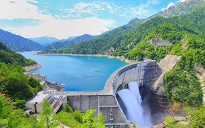
Video article 18:20
Admire the Breathtaking View of the Venus Line at Kirigamine Plateau in Early Summer in Nagano Prefecture From the Sky!
Travel Nature- 212 plays
- YouTube
ドローンで撮影された絶景の長野県霧ヶ峰高原ビーナスラインとは こちらの動画は「Yatsugatake21_4K_Japan」が公開した「4K 絶景ドローン「初夏のビーナスライン 霧ヶ峰高原」癒し空撮自然映像 Drone Japan Nature Relaxation Venus line」です。 長野県の霧ヶ峰高原ビーナスラインをドローンの空撮で捉えた映像になっています。 長野県霧ヶ峰高原ビーナスラインとは、八ヶ岳中信高原国定公園 の高原地帯を走るツーリングにはもってこいのドライブルート。 全長76kmにも及び、蓼科高原・白樺湖・車山高原・霧ヶ峰高原・八島高原・美ヶ原高原といった森林地帯や高原地帯の四季を望むことのできる絶景スポットです。 平均の標高は1,400mで最高では1,920mにもなります。 野県霧ヶ峰高原ビーナスラインのおすすめルート 長野県霧ヶ峰高原ビーナスラインの中でおすすめのルートは白樺高原から霧ヶ峰のルートです。 これは白樺湖から出発し、車山展望リフトで車山山頂へ。 こちらでは、天気が良ければ八ヶ岳連峰や富士山まで望むことができます。 また紅葉やニッコウキスゲなどの草花も楽しむことができます。 その先には霧ヶ峰富士見台があります。 こちらでは食事処やお土産屋などの売店も充実しています。 最後にはレストラン「チャップリン」でソースカツ丼やカツカレーを楽しめます。 長野県霧ヶ峰高原ビーナスラインには人気のドライブインも 長野県霧ヶ峰高原ビーナスラインの中心には人気のドライブインである霧ヶ峰高原ビーナスラインドライブイン霧の駅があります。 ここでは長野県の様々なお土産を買うことができ、駐車場のそばには八島湿原や三峰大展望台・霧ヶ峰自然保護センターもあります。 動画では3:31より美しい自然の景色を見ることができます。 長野県霧ヶ峰高原ビーナスラインから諏訪湖へ 新日本三大夜景やサンセットをご覧になることのできる立石公園も霧ヶ峰高原ビーナスラインの見どころです。 映画「君の名は。」のモデルになったと言われるスポットとしても有名です。 長野県霧ヶ峰高原ビーナスラインでもお参りを 長野県霧ヶ峰高原ビーナスラインのなかには諏訪大社上社本宮・諏訪大社下社秋宮といった神社にも触れるができます。 諏訪大社上社本宮は国内最古の神社の一つで、八ヶ岳や諏訪平などを望むことができます。 また画家の岡本太郎さんが絶賛した万治の石仏という石像もあります。 こちらは諏訪大社下社春宮から徒歩5分ほどの場所にあるので、諏訪大社下社春宮のお参りを終えたら是非訪れてみましょう。 その他長野県霧ヶ峰高原ビーナスラインの旅行スポット 長野県霧ヶ峰高原ビーナスラインではこれら以外にも様々な施設に楽しむことができます。 国指定重要文化財である片倉館、県下最大級のガラスミュージアムであるSUWAガラスの里、400年の歴史がある高島城、無料で足湯につかれる湖畔公園足湯と豊富な温泉があります。 自然と観光を楽しめる長野県霧ヶ峰高原ビーナスライン紹介まとめ 大自然の景色を楽しみながらドライブできる長野県霧ヶ峰高原ビーナスラインをみなさまも楽しんでください! -
Video article 1:01
An Impressive View of the First Sunrise of the Year at Mt. Fuji – Helicopter Footage From 4,000 Meters + 5 Spots for Watching the First Sunrise of the Year Over Mt. Fuji
Nature Travel- 159 plays
- YouTube
Mt. Fuji – Hatsuhinode: Video Introduction This video, titled "An Aerial View of Mt. Fuji | The First Sunrise of 2022【Shizuoka Shimbun / Your Shizuoka Newspaper】" (富士山上空 2022年初日の出【静岡新聞/あなたの静岡新聞】) was uploaded by "Shizuoka Shimbun【TEAM NEXT】." Jelico No.1, a helicopter owned by Shizuoka Newspaper Inc., filmed Mt. Fuji and the first sunrise of 2022 at approximately 4,000 meters above Fujinomiya, Shizuoka, in Japan's Tokai region. Hatsuhinode is the Japanese tradition of viewing the first sunrise of the New Year. Enjoy the breathtaking sunrise over Mt. Fuji! A Divine View of Mt. Fuji and a Sunrise That Will Take Your Breath Away! Photo:The first sunrise of the year, Mt. Fuji If you're superstitious, then there's nothing more auspicious than Mt. Fuji and hatsuhinode to greet the new year. Moreover, this combination is filmed at the height of 4,000 meters. It's going to take your breath away. [Video] 0:18 - Snow Whirling in the Wind on Mt. Fuji as the Sun Rises In this video, you can also see the rare Kage-Fuji, a phenomenon which can only be seen for a few hours before sunrise and sunset, when only oblique light shines on Mt. Fuji. The shadow of Mt. Fuji can be seen on the surface of the earth or on a sea of clouds. The first sunrise of the year coupled with the Kage-Fuji phenomenon makes for an incredible experience. [Video] 0:30 - The Magnificent Scale of Kage-Fuji Seen From the Sky The photogenic Kage-Fuji in the crisp air is a different experience from what climbers can see, creating a fantastic sight that can only be captured from 4,000 meters in the air. Recommended Spots for Viewing Mt. Fuji and the First Sunrise of the Year Photo:Sunrise and Mt. Fuji from Lake Motosu Mt. Fuji is also called "Reiho" (霊峰), or "sacred mountain" in Japanese, and is loved by the people of Japan. No matter the season, this place is always a popular attraction. Now you're probably thinking "It must be crowded during Hatsuhinode then." Crowding conditions vary from year to year, but here we'll introduce some popular spots and hidden gems where you can view Mt. Fuji. Be sure to take a camera for some awesome photos as well! ●Lake Kawaguchi (河口湖, Kawaguchiko) (Popular) On the side of the lake, there are so many places where you can enjoy views of Mt. Fuji, like Oishi Park (大石公園, Oishi Koen) or Ubuyagasaki (産屋ヶ崎, Ubuyagasaki). The first sunrise of the year rising over the majestic Mt. Fuji illuminates the surface of the lake with a beautiful light. Fuji Sengen Shrine (about 20 minutes away by car) is located nearby and is recommended for hatsumode (the first shrine visit of the New Year). Sunrise: 6:54 a.m., January 1, 2022 ●Lake Motosu (本栖湖, Motosuko) (Popular) The famous Sakasa-Fuji (the upside-down reflection of Mt. Fuji on the surface of a lake) printed on 1,000-yen notes came from the view from this lake. This spot is popular as a top photo spot to witness Diamond Fuji, a beautiful phenomenon where the sunrise hits the peak of Mt. Fuji and shines like a diamond. Unfortunately, whether or not you can see this will depends on the day's weather, so there's no guarantee you'll be able to see it. Sunrise: 6:49 a.m., January 1st, 2022 ●Roadside Station Asagirikogen (道の駅 朝霧高原, Michinoeki Asagirikogen) (Popular) Here, visitors can enjoy restaurants and a variety of local products. Only on January 1st, this area opens at 7:00 AM to warmly welcome people who come there to take photos or enjoy the first sunrise of the year. It's located along Shio no Michi (Salt Road), Route 139, which links Shizuoka with Yamanashi. Sunrise: 6:55 a.m., January 1st, 2022 ●Jukkoku Toge Summit (十国峠山頂, Jukkoku Toge Sancho) (Hidden Gem) The Hakone Jukkoku Toge Cable Car starts running from 5:00 a.m. as a "Hatsuhinode Special Service." On a bright and clear New Year's Day, you can catch Mt. Fuji colored red by the sunrise. Sunrise: 6:52 a.m., January 1st, 2022 ●Senbonhama Beach (千本浜海岸, Senbonhama Kaigan) (Hidden Gem) This beach is approximately 10 km long and is full of pine trees. It's a nice spot where you can avoid the crowds in the area surrounding Mt. Fuji and enjoy the beautiful pine trees with a distant view of Mt. Fuji. Sunrise: 6:52 a.m., January 1st, 2022 Each spot has special New Year's tours. If you're in Japan for the new year, consider staying at a hotel or ryokan and watching the beautiful sunrise over Mt. Fuji. Climbing Mt. Fuji to See the First Sunrise of the Year? Photo:Sunrise, Mt. Fuji There are many people that want to witness the sunrise from the peak of Mt. Fuji. However, the climbing season on Mt. Fuji doesn't start until early July and ends in late September. In general, the climbing season is during the period when the trails are open to the public. Since the opening period differs by trail, please refer to the Official Website for Climbing Mt. Fuji. New Year's means winter on Mt. Fuji, and weather conditions can be harsh, leading to an increased risk of accidents. Therefore, if you're planning on climbing Mt. Fuji, be sure to keep this in mind and be extra careful. Summary of the First Sunrise of the Year at Mt. Fuji This article introduced information about the first sunrise of the year at Mt. Fuji, a sight that many people wish to see. There are tons of good places to watch the sunrise, including popular spots and hidden gems. There are also risks to be aware of if you're planning on climbing Mt. Fuji to watch the first sunrise of the year. Having a good New Year's Day is the key to having a good year. Watching the sunrise at Mt. Fuji is one of the best ways to start your year off right. Be sure to dress warm and enjoy the amazing view! 【TripAdvisor】Mt. Fuji -
Video article 5:14
Mt. Yoshino in Nara Prefecture – Experience a Panoramic View of 30,000 Beautiful Cherry Blossoms at One of the Most Famous Cherry Blossom Viewing Locations in Japan
Travel Nature- 196 plays
- YouTube
The Breathtaking Cherry Blossoms of Mt. Yoshino This video, titled "Yoshino Cherry Blossoms 吉野山の桜 [8K]," was uploaded by "Japan Explorers." Enjoy the beautiful cherry blossoms of Mt. Yoshino in high-quality 8K video, that truly captures the scenery of Japan. Mt. Yoshino, introduced in the video, is a generic name for the ridge of mountains leading from the south bank of the Yoshino River to the Omine Mountain Range in the town of Yoshino in Yoshino County, Nara Prefecture, located in Japan's Kansai region. There is also a theory that it is the name of a wide area dotted with temples and shrines, centering on Kinpusenji Temple. The area around Mt. Yoshino is said to be a famous place for flowers, not just their famous cherry blossoms, and there are even records that tell of Toyotomi Hideyoshi visiting for cherry blossom viewing. From 1:29 in the video, you can see the beautiful cherry blossoms in full bloom in front of the main hall of Kinpusenji Temple (Zao Hall), a World Heritage Site. Yoshinoyama is usually at its best from early to mid-April; in 2023, the cherry blossoms were in full bloom from March 30 to April 3, earlier than usual. Why not check the blooming status and visit this spring? When is the best time to view the cherry blossoms at Yoshinoyama? Why is it called the best cherry blossom viewing spot in Japan? Photo:The Senbonzakura of Mt. Yoshino, Yoshino, Nara There are many famous places for cherry blossom viewing in Japan, and all of them have splendid views of cherry blossoms worthy of a title, but there's a good reason why the cherry blossoms of Mt. Yoshino are said to be "the best in Japan." The vocaloid masterpiece "Senbonzakura" (千本桜, lit. One Thousand Cherry Blossoms) is said to have been inspired by the thousand cherry blossoms of Mt. Yoshino. Moreover, from the beginning to the end of April, the cherry blossoms bloom up the mountain in ascending order starting with the thousand at the foot of the mountain, followed by the thousand of the middle section, the thousand at the peak of the mountain, and finally the thousand in the deeper reaches of the mountain. In other words, it can be said that Mt. Yoshino is worthy of the title "No. 1 in Japan" simply because it allows for cherry blossom viewing for an entire month. Yoshino-Kumano National Park, which includes Mt. Yoshino, is designated as a National Place of Scenic Beauty and a historic site, and Mt. Yoshino is also included in the "Sacred Sites and Pilgrimage Routes in the Kii Mountain Range," a UNESCO World Heritage Site. Naturally, it has also been selected as one of the " Top 100 Places to View Cherry Blossoms in Japan." The History of Mt. Yoshino, the Most Famous Place to View Cherry Blossoms in Japan Photo:The Yoshino Ropeway, Yoshino, Nara The history of cherry blossoms on Mt. Yoshino dates back more than a thousand years with documents mentioning the cherry blossoms of Mt. Yoshino as far back as the Heian period (794-1185). Since the Yoshino Cherry, which bears the name "Yoshino," is an ornamental cherry tree that was refined during the Edo period (1603-1868 A.D.), there are many more varieties planted on Mt. Yoshino, and it is said that there are approximately 30,000 of them covering the entirety of the mountain. The reason why Mt. Yoshino became a famous place for cherry blossoms is that cherry blossoms were considered to be the sacred tree of Zao Gongen, a mountain deity of Shugendo, an ancient religion in Japan. It is said that En no Ozuno, considered the founder of Shugendo, practiced asceticism on Mt. Kinpu and attained enlightenment through the manifestation of the bodhisattva Zao Gongen. At that time, they carved a statue of the bodhisattva Zao Gongen out of a cherry tree and worshipped it, and it became a custom for mountain ascetics in the past to carve a statue of Zao Gongen out of a cherry tree on Mt. Yoshino. As a result, cherry trees were planted all over the mountain, and it became a popular topic of conversation among commoners as a place where they could view thousands of splendid cherry blossoms in one location, making it the most famous cherry blossom viewing location in Japan. Furthermore, the Yoshino Ropeway, the oldest ropeway in Japan, is another must-see location for cherry blossom viewing. It was founded in 1929 and has a history of more than 90 years. The pillars, built in 1928 when the ropeway opened, are in use even now, showcasing the high-level Japanese architectural technology, even at that time. The Recommended Route for Cherry Blossom Viewing on Mt. Yoshino Photo:Senbonzakura seen from the Hanayagura Observatory, Yoshino, Nara Mt. Yoshino is a place for leisurely enjoyment that can be enjoyed throughout all of Japan's four seasons. You can enjoy not only the cherry blossom season, but also autumn leaves, early summer hydrangeas, snowy winter scenery, the hot springs of Yoshino, temples and shrines, and even quiet places to go for a walk through the forests of Yoshino. In particular, the recommended route for viewing the cherry blossoms is from Yoshino Station to Saigyoan. On the way you'll see: ・Kumoi-no-Sakura (雲井の桜) ・Takizakura (滝桜) ・Nunobiki-no-Sakura (布引の桜) ・Tennin-no-Sakura (天人桜) ・Yumemizakura (夢見桜) ・Goshozakura (御所桜) ・Arashiyama-no-Sakura (嵐山の桜) ・Sekiyazakura (関屋桜) ・Yonhonzakura (四本桜) ・Senbonzakura (千本桜) ・Hanazonosan-no-Sakura (花園山の桜) These are the famous places you can stop by where many wild cherry trees can be seen in full bloom. In addition, the views from Hanayagura Observatory and Shimosenbon Observatory at an elevation of about 600m, showcase a panoramic view of 30,000 cherry blossoms of around 200 different species! When they're in full bloom, they're lit up and you can enjoy spectacular views of cherry blossoms at night. Since Mt. Yoshino covers a large area, it's also recommended as a driving course for private vehicles, rental cars, and buses. Summary of Mt. Yoshino, the Most Famous Place to View Cherry Blossoms in Japan In this article, we introduced some of the history and highlights of Mt. Yoshino alongside the video showcasing the cherry blossoms in full bloom. We hope you enjoyed it! There are many other attractions around Mt. Yoshino, such as Zao Hall, and Yoshimizu Shrine, both World Heritage Sites. Also, since it was originally a sacred place for Shugendo, there are plenty of accommodation facilities, such as Sakuramotobou (桜本坊) that were originally for mountain ascetics. Please check the official website of the Mt. Yoshino Tourism Association for directions to Mt. Yoshino, parking information, bloom forecasts, and more. The mascot character "Pinkle" chan will guide you! 【Official Website】Mt. Yoshino Tourist Association, Nara Prefecture http://www.yoshinoyama-sakura.jp/english/ 【TripAdvisor】Mt. Yoshino https://www.tripadvisor.com/Attraction_Review-g1121327-d1384139-Reviews-Mt_Yoshino-Yoshino_cho_Yoshino_gun_Nara_Prefecture_Kinki.html -
Video article 6:18
A Beautiful Night View From the Restaurants at Abeno Harukas! Enjoy the Stunning Views of Osaka From Harukas 300 in This Stunning Video!
Travel Art & Architecture- 75 plays
- YouTube
Harukas 300 – The Abeno Harukas Observatory: Video Introduction Photo:Abeno Harukas and an 'OSAKA' sign This video, titled "Night View from Harukas 300, the Abeno Harukas Observatory, Osaka, Japan) (あべのハルカス展望台 ハルカス300からの大阪夜景), was uploaded by "Night Movie Channel of Osaka Japan." At 300 meters (984 ft.) tall, Abeno Harukas, which opened in March 2014, is the tallest skyscraper in Japan. The skyscraper is located in the Abeno Ward of Osaka City. The Abeno Harukas observation deck, named Harukas 300, is located on floor 58-60 of Abeno Harukas. The night view from Harukas 300 is known as a spectacular spot from which to view the entire city of Osaka. Be sure to check it on in the video as you read on! [Video] 0:07 - Abeno Harukas [Video] 0:58 - Night View of Osaka From the Observatory Gallery at Harukas 300 [Video] 4:50 - Harukas 300's Sky Garden More About Harukas 300, the Abeno Harukas Observatory Photo:People enjoying the view from Harukas 300, the observation deck of Abeno Harukas Abeno Harukas is a 60-story skyscraper completed in 2014 in the Abeno Ward of Osaka City. The name Abeno Harukas is derived from the name of the Abeno district where it is located, and the ancient word harukasu, meaning "to clear the skies." Because of its diverse facilities, such as department stores, restaurants, museums, offices, hotels, and observation decks, all housed in one city-like area, Abeno Harukas has become a popular tourist attraction in Osaka. Abeno Harukas' observatory, Harukas 300, is Japan's tallest tower at 300 meters (984 ft.) and consists of three levels on the 58th, 59th, and 60th floors. Many tourists visit the observatory every day to catch a glimpse of the breathtaking view. The observatory gallery, located on the top floor of Harukas 300, is made completely of glass, giving visitors the unique sensation that they're walking on air. From the corridor, visitors can enjoy a panoramic view of central Osaka, Osaka Bay, and Mt. Ikoma. In addition, if the weather permits it, you can even see Mt. Rokko, Kyoto, Akashi Kaikyo Bridge, Awaji Island, Mt. Ikoma, and Kansai International Airport. In addition to the observatory gallery, there is an outdoor area called Sky Garden which is surrounded by plants, making it a great place to relax. Various events are held here as well. There are also cafés, restaurants, and stores inside the observatory, where you can enjoy a meal or a drink along with the view. Harukas 300 Tickets, Discounts, and Free Gardens Photo:Abeno Harukas Admission to Harukas 300 is 1,500 yen for adults, 1,200 yen for junior high and high school students, 700 yen for elementary school students, 500 yen for young children, and free for children under 3 years of age. Visitors with disabilities and groups can enter at a discounted rate. Same-day tickets can be purchased at the ticket counter on the 16th floor of Abeno Harukas on a first-come, first-served basis. If you are traveling from far away, you can purchase advance vouchers or e-tickets to shorten your wait time. Advance vouchers can be purchased at Kintetsu Station sales offices, and e-tickets can be purchased online in advance. Both are valid for 30 days from the date of purchase. Harukas 300 1-day tickets, which allow re-entry into the facility, are 1,950 yen for adults, 1,650 yen for junior high and high school students, 950 yen for elementary school students, 750 yen for young children, and free for children under 3 years of age. In addition, Harukas Wing Garden, located on the 10th floor rooftop of Abeno Harukas' Wing Building, is an area with free admission and benches to sit and rest. Events and other events are held in the space, and in winter there are also illuminations. Enjoy the Night View at Harukas 300 With the Heliport Tour! Photo:The night view from Harukas 300, the observation deck of Abeno Harukas Abeno Harukas also has a heliport on its rooftop. Here you can enjoy the Harukas 300 Heliport Tour. The attraction of this tour is that you can monopolize the spectacular view from 300 meters above the ground, the highest point in Japan, while feeling the wind on your skin. Heliport tours are conducted 15 times a day, but we particularly recommend the nighttime tour. The nighttime heliport tours allow you to enjoy a beautiful night view of Osaka in a romantic atmosphere. A Dinner Date With a View – Restaurants at Abeno Harukas Photo:The night view from Harukas 300, the observation deck of Abeno Harukas There are a number of restaurants at Abeno Harukas with beautiful night views that are great for a date. Here are three restaurants at Abeno Harukas that we recommend for dinner. ●Restaurant ZK in Osaka Marriott Miyako Hotel - 57th Floor Osaka Marriott Miyako Hotel is located on the upper floors of Abeno Harukas. Restaurant ZK is located on the 57th floor, the top floor, and promises a beautiful view of the city of Osaka. The menu is characterized by its fusion of Japanese and Western ingredients. ●BAR PLUS in Osaka Marriott Miyako Hotel - 19th Floor An open bar located on the 19th floor front lobby of the Osaka Marriott Miyako Hotel. It offers a variety of light meals and alcoholic beverages, making it an elegant place to enjoy a night out. ●Aloha Table Abeno Harukas Dining - 14th Floor Aloha Table is an open-plan restaurant divided into a café/dining area and a bar space. The carefully selected interior and Hawaiian music create a relaxing space that will make you feel as though you've taken a trip to Hawaii. Unlike the bright scenery during the day, you can enjoy the beautiful night view of Osaka in the calm lighting at night. Enjoy the beautiful night view as well as the gastronomic delights at the various restaurants at Abeno Harukas. We recommend making reservations in advance if you're interested in a window seat. Things to Do at Abeno Harukas Photo:The view from the glass floor of Harukas 300, the Abeno Harukas observation deck Abeno Harukas houses numerous tourist attractions and hosts a wide variety of events. For example, EDGE THE HARUKAS is a newly built attraction at the top of the building, 300 meters above the ground. Visitors can enjoy walking along the edge of the building with a lifeline attached to them. The Abeno Harukas Art Museum, conveniently located within Abeno Harukas, has a high ceiling and 880 square meters of exhibition space. The museum hosts a variety of temporary exhibits, including both Asian and Western art and a wide range of art events are held here. The museum is popular among locals and tourists alike. Things to Do Near Abeno Harukas Photo:Shitennoji Temple in Osaka Below is a list of tourist attractions we recommend checking out near Abeno Harukas. Shitennoji Temple Founded in 593, Shitennoji Temple is one of, if not the, oldest temple in Japan. It was founded by Prince Shotoku, a legendary figure in Japanese history. The temple is home to a 5-story pagoda, a lovely garden where you can enjoy cherry blossoms in spring, and the temple hosts a variety of events throughout the year. Hours: Temple/Central Temple/Garden: 8:30 am - 4:30 pm (April - September), 8:30 am - 4:00 pm (October - March) ※Besides the areas listed above, the gate for Shitennoji Temple is open 24 hours. Tsutenkaku Tower One of the most famous landmarks in Osaka, the original Tsutenkaku Tower was built in 1912, although it was destroyed by a fire in 1943 and rebuilt in 1956. The Tower Slider, a 60-meter-long slide, is a new attraction that visitors can enjoy at the tower. Hours: 10:00 am - 8:00 pm (7:30 pm last admission) Admission Fee: Adults: 900 yen, Children (ages 5 to junior high school students): 400 yen. ※Discounts are available for groups of 10 or more. Tennoji Zoo Tennoji Zoo opened in 1915 and is home to a variety of animals, including polar bears, penguins, giraffes, lions, etc. Hours: 9:30 am - 5:00 pm Admission Fee: Adults: 500 yen, Junior high and elementary school students: 200 yen, Preschoolers and younger: Free How to Get to Abeno Harukas Photo:Tennoji Station, Osaka There are a number of ways to get to Abeno Harukas depending on where you're coming from; below we'll introduce a few of them. Osaka International Airport to Abeno Harukas If you're traveling to Japan and will be landing in Osaka, or will be leaving Japan via Osaka International Airport, this is far and away the simplest way to get to Abeno Harukas. There is a scheduled limousine bus to Abeno Harukas that departs every 30 minutes from Osaka International Airport. The bus will take you to Osaka Abenobashi Station and from there it's a 5-minute walk to Abeno Harukas. That same limousine bus departs from Abeno Harukas for Osaka International airport every 30 minutes as well. The bus ride is 30 minutes each way and costs 650 yen per person. Kansai International Airport to Abeno Harukas From Kansai International Airport, you can take the Haruka 34 limited express train to Tennoji Station and from there it's a 2-minute walk to Abeno Harukas. Just like the limousine bus from Osaka International Airport, this train is scheduled every 30 minutes, but the fare is 2,370 yen per person. Kyoto to Abeno Harukas To get to Abeno Harukas from Kyoto, it's a 45-minute train ride via the Haruka 37 limited express train which will take you from Kyoto Station to Tennoji Station. The fare is 2,680 yen per person. From anywhere else in Japan, the easiest way to get to Abeno Harukas is to head towards Tennoji Station, the nearest station, and from there walk to Abeno Harukas. Summary of Abeno Harukas Photo:The view from the observatory of Abeno Harukas The observation deck Harukas 300 is located on the top floor of Abeno Harukas, the tallest skyscraper in Japan. The view from 300 meters (984 ft.) above the ground is breathtaking, offering a panoramic view of Osaka City and the surrounding landscape. From couples to family trips, Abeno Harukas can be enjoyed in all kinds of ways. Be it a date or other special occasion, why not enjoy a meal at Harukas 300 while viewing a beautiful night view of Osaka? 【Official Website】Abeno Harukas 【TripAdvisor】Abeno Harukas -
Video article 15:24
Spring Is a Wonderful Time of Year When the Whole of Kyoto Is Bathed in the Brilliant Colors of Cherry Blossoms! Explore Some of Kyoto’s Most Popular Cherry Blossom Viewing Locations!
Travel- 92 plays
- YouTube
Introducing Some of the Best Cherry Blossom View Locations in Kyoto! This video, titled "4K JAPAN, Cherry Blossoms in Kyoto, Kyoto, Sightseeing, Travel, Hanami, Full Bloom, Sewaritei, Kiyomizudera, Arashiyama, Gion Shirakawa, Kyoto Botanical Gardens, Heian Jingu Shrine, Okazaki Canal, Byodoin, Kamogawa, Sakura" (4K JAPAN 京都の桜 Cherry blossoms Kyoto 京都 観光 旅行花見 満開 背割堤 清水寺 嵐山 祇園白川 京都植物園 平安神宮 岡崎疏水 平等院 鴨川 sakura), was uploaded by "Discover Nippon." It condenses the beautiful scenery of Kyoto into one video. As you can see from the video, there are many cherry blossom viewing spots in Kyoto, so get out there and see them for yourself! Explore Some of Kyoto’s Most Popular Cherry Blossom Locations! One of the most popular cherry blossom viewing spots in Kyoto is Kiyomizudera, a temple and World Heritage Site known for the "Stage of Kiyomizu," its three-story pagoda, and Hojo Pond. The temple grounds can be seen from 7:33 in the video. At Kiyomizu-ji Temple, "Night Special Visits" are held three times a year.Spring, when cherry blossoms are at their best, is from March 23rd to March 31st, 2024.The opening time of the gate has been extended until 21:30, so please enjoy the collaboration between fantastic cherry blossoms and historical buildings. Photo:Cherry blossoms and Tatsumi Bridge in Gion Shirakawa, Kyoto The Gion Shirakawa Sakura Light-up is held at Gion Tatsumi Bridge in the Instagrammable Gion Shirakawa area, there are about 43 weeping cherry trees in "Gion Tsubashi.""Gion Shirakawa Sakura Light Up" will be held at the best time to see the cherry blossoms.2024 will be lit up from March 22nd to 31st from 18:00 to 22:00, so please enjoy the fantastic night cherry blossoms that emerge in Kyoto's tasteful streets. If you want to enjoy an unusual experience during the cherry blossom season, go to the gagaku performance of the Heian Jingu Shrine's Kanzakura Tea Ceremony and the Red Shidare Concert, which you can see from the video 6:15. "Heian Shrine" where you can enjoy cherry blossoms while enjoying matcha." The Kanzakura Tea Ceremony will be held from March 31st to April 11th, 2024.The Red Shidare Concert, which will be held in the illuminated cherry blossoms, will be held from April 3rd to the 7th, 2024. 4:46 is a popular cherry blossom viewing spot where you can also see Okazaki Sosu and Lake Biwa Sosu on Instagram. Photo:Cherry blossoms along the bank of the Kamo River, Kyoto Also consider checking out the "Flower Corridor" on the Kamo Riverbank between Shichijo Bridge (七条大橋) and Sanjo Bridge (三条大橋), as well as Kamo River Park in Kamogawa, and Nakaragi no Michi between Kitayama Bridge (北山大橋) and Kitaoji Bridge (北大路橋). The Kyoto Botanical Garden located near Nakaragi no Michi features beautiful red tulips and is a must-see. On the other side of the Iwashimizu Hachimangu Shrine, there is a tunnel of cherry blossom trees along the Yodogawa River Park's Sewaritei Bank. This is shown at 2:53 in the video. At the Sewaritei Cherry Blossom Festival, you can enjoy cherry blossom viewing under roughly 1,500 cherry trees of various types, including Someiyoshino and Yamazakura. Be sure not to miss the Sakura-deai Visitor Center and the observation tower that were built on the bank in 2017. Photo:Cherry blossoms at Togetsukyo Bridge, Kyoto In the cherry blossom forests of Hirano Shrine and Haradani-en Garden, you can see rare varieties of cherry blossoms, including some with yellow or green petals. You can also see the cherry blossoms at Nakanoshima Park and Togetsukyo Bridge in Arashiyama along the Oigawa River, which can be seen at 9:37 in the video. There are also many other places in Kyoto that are perfect for walking around cherry blossoms and cherry blossom viewing, including Daigoji Temple, Byodoin's Phoenix Hall, and Hieizan Enryakuji Temple. Summary of Cherry Blossoms in Kyoto There are many cherry blossom viewing spots in Kyoto, from well-known landmarks to hidden gems. Be sure to check the cherry blossom forecast before your trip to Kyoto to see the cherry blossoms when they're in full bloom. -
Video article 1:56
Spring Quartet: Enjoy Cherry Blossoms Along the Funakawa River in Toyama! Beautiful Views That Only a Drone Could Capture!
Travel Nature- 105 plays
- YouTube
Spring Quartet – Cherry Blossoms Along the Banks of the Funakawa River: Video Introduction This video, titled "[SAKURA DRONE] Asahi, Toyama & Cherry Blossoms|Drone Project 4K" ([SAKURA DRONE] Asahi-machi, Toyama-Ken & cherry blossoms|富山県朝日町|桜ドローンプロジェクト 4K), was uploaded by "Sakura Drone Project - Drone Entertainment Co." (桜ドローンプロジェクト - 株式会社ドローンエンタテインメント). Spring Quartet: A Collaboration in Nature Photo:Cherry blossoms along the Funakawa River, Toyama Prefecture In Asahi, Toyama, located in Japan's Koshin'etsu Region, there is a beautiful landscape referred to as the "Spring Quartet." This miraculous landscape is created through a combination of the mountains of the Northern Alps, rows of cherry blossoms along the Funakawa River, tulips, and rape blossoms. You can enjoy the beautiful Japanese spring woven by nature in Toyama Prefecture. Beautiful Cherry Blossoms Along the Banks of the Funakawa River This video features drone footage of Spring Quartet. It begins with beautiful footage of cherry blossoms and rape blossoms against a backdrop of mountains. The video of the rows of cherry trees along the banks of the Funakawa River shows 280 Someiyoshino cherry trees from the sky and various other angles that only drone photography can provide. [Video] 0:14 - Rows of Cherry Blossoms From the Sky [Video] 1:05 - Flying Through the Cherry Blossoms The cherry blossoms usually bloom in early April in Toyama Prefecture, but be sure to check the blooming conditions if you want to visit at the best times. Full bloom was mid-April in 2022. Toyama Life, Toyama Prefecture's local information website, has published information on the best times to visit Asahi Funakawa Spring Quartet. The rows of cherry blossoms along the Funakawa River are illuminated at night during the blooming period. Visitors can also enjoy bonfires and nighttime cherry blossoms, make it a very memorable event. Spring Quartet Events and Initiatives Photo:Cherry blossoms along the Funakawa River, Toyama Prefecture An annual cherry blossom festival is held at the cherry blossoms lining the banks of the Funakawa River, and musical events are also held. The Spring Quartet 2022 Instagram Photo Contest was also held this year. The photo contest seems to be held every year, so consider participating and taking photos in some of the beautiful spots you can find in the area. In addition, to help the tulip bulbs by the cherry blossoms lining the banks of the Funakawa River grow bigger, a tulip flower-picking team is being recruited. This is an effort to pick the flowers and preserve the beautiful scenery for years to come. In addition, there will be other things to enjoy, such as rice paddy art. Summary of Spring Quartet Be sure to check out the beautiful Japanese scenery of cherry blossoms along the Funakawa River at the Spring Quartet if you still haven't yet. If you're planning on going to the event, remember to look up the best times to see the cherry blossoms so you can get the most out of your sightseeing trip. To reach the Funakawa River cherry blossoms, shuttle buses from Asahi General Hospital and Asahi Cultural and Sports Center are available on Saturdays and Sundays. Note that parking near the cherry blossoms is only available on weekdays. The beautiful and uniquely Japanese scenery of Asahi Funakawa, where you can enjoy rows of cherry blossoms, rape blossoms, and tulips against the backdrop of Japan's Northern Alps, including the Asahi and Hakuba Mountains, awaits your arrival! 【Official Website】Asahi Tourism Association / Asahi Funakawa Spring Quartet https://www.asahi-tabi.com/sijuusou/ 【TripAdvisor】Funakawa River Cherry Blossoms https://www.tripadvisor.com/Attraction_Review-g1121157-d13442353-Reviews-Funagawa_Berisakura_Namiki-Asahi_machi_Shimoniikawa_gun_Toyama_Prefecture_Hokur.html -
Video article 1:24
Enjoy a moment of elegance in a luxurious space with an ocean view in every room at Umi no Hotell Isaba in Nishi Izu, Numazu City, Shizuoka Prefecture. With its relaxing hot springs and cuisine, this is a wonderful place that you must visit at least once.
Hotel & Japanese Inn- 101 plays
- YouTube
Video Introduction of "Umi no Hotell Isabara," a popular inn in Numazu City, Shizuoka Prefecture, Nishi-Izu This video, titled "Umi no hotel ISABA” YADO PV/JAPAN : 宿PV 海のほてるいさば02," was uploaded by "private-onsen JAPAN." Umi-no Hotel Isaba is located in Heda Onsen, a famous hot spring resort in Nishiizu, Shizuoka Prefecture. Surrounded by Mt. Fuji and Suruga Bay, this is a hot spring hotel in a fishing town that's crowded with beachgoers in the summer. All guest rooms at Umi-no Hotel Isaba are luxurious oceanfront accommodations. Suruga Bay is a treasure trove of seafood with approximately 1,200 species of fish, including deep-sea species! At Umi-no Hotel Isaba, you can enjoy the freshest seafood from Suruga Bay in a luxurious setting. You can see some of the gorgeous dishes served at Umi-no Hotel Isaba at 0:57 in the video. The hot spring is an alkaline sulfur hot spring that is very popular among women as it's effective at promoting beautiful skin. The hotel's hot spring facilities include a large public bath, an open-air rooftop bath called "Tenku Onsen," and each room has its own personal hot spring, so you can relax to your heart's content. The rooftop hot spring overlooking Suruga Bay is also available for private use once per stay. The hot springs at Umi-no Hotel Isaba can be seen at 0:37 in the video. The rooms are very luxurious and we highly recommend the special room floor "Akane-no-Uta," which was renovated and reopened in July 2020! There is also a beauty spa, souvenir shop, terrace lounge, and lobby, all of which are very beautiful! Why not relax and spend a luxurious holiday at Umi-no Hotel Isaba? Sightseeing Around Umi-no Hotel Isaba Photo:Mihama Cape, Shizuoka Prefecture Nishiizu in Shizuoka Prefecture, one of the most popular tourist destinations in Japan, has many spectacular sightseeing spots. Let's take a look at some of them! ・Mihama Cape Mihama Cape is a cape shaped like a bird's beak, and was formed through the accumulation of sediment carried in by the currents of Suruga Bay. It's also a good fishing ground where you can enjoy fresh seafood at lunch time. ・Deai Misaki Cape This is a great sightseeing spot with a panoramic view of Heda Port, Mihama Cape, and Mt. Fuji. The name "Deai" (出会い) means "encounter" and the monument, from the hole of which you can see Mt. Fuji, signifies a meeting between two lovers. ・Tabibito Misaki Cape Tabibito Misaki Cape is located about 1km north of Matsubara Park on Prefectural Road 17. The beauty of the sunset that can be seen from here is absolutely breathtaking. The name "Tabibito" (旅人) means "traveler(s)." ・Koibito Misaki Cape Koibito Misaki Cape is a cape along Route 136, approximately 8 km south of Toi Onsen. "Koibito" (恋人) means "lovers," and, as its name suggests, it's a popular location among couples as a power spot for romance. It is said that couples who take a photo with the "I Love You" hand-sign statue on the cape or get a certificate of declaration of love from the Koibito Cape Office are said to have a better chance of achieving a successful relationship. (Whether or not you believe that is entirely up to you...) Summary of Umi-no Hotel Isaba, a Popular Hotel in Nishiizu, Shizuoka Prefecture Photo:Umi-no Hotel Isaba, Shizuoka Prefecture To get to Umi-no Hotel Isaba, a hotel popular for its many attractions and luxurious facilities, it's about a 50-minute bus ride from Shuzenji Station to Heda (a shuttle bus is also available). All-you-can-eat mandarin oranges are available from November to December every year, and the Kawazu Cherry Blossom Festival is held from mid-February to early March every year, attracting many tourists. Be sure to check with your travel agency or the official website of Umi-no Hotel Isaba for information regarding accommodation rates and tours. ◆Umi-no Hotel Isaba|Facility Overview◆ 【Address】3878-20 Heda, Numazu City, Shizuoka Prefecture 【Access】Approximately 50 minutes by bus from Shuzenji Station to Heda. A shuttle bus is also available 【Telephone】0558-94-3048 【Official Website】Umi-no Hotel Isaba https://www.isaba.co.jp/en/ 【Tripadvisor】Umi-no Hotel Isaba https://www.tripadvisor.com/Hotel_Review-g1019668-d1065897-Reviews-Isaba-Numazu_Shizuoka_Prefecture_Tokai_Chubu.html -
Video article 5:38
Taste the great outdoors at Kamikochi in the Japanese Alps, a spectacular sightseeing spot in Matsumoto City, Nagano Prefecture, Shinshu! Surrounded by greenery full of negative ions, spend a healing time.
Nature- 151 plays
- YouTube
Introduction of "Japan Alps Kamikochi" sightseeing video in Matsumoto City, Nagano Prefecture This video, titled "LEAP | Kamikochi (上高地) - Japan - UHD 4K," was released by Jonathan Teo. It shows an aerial view of Kamikochi, a tourist resort area overflowing with natural beauty in Nagano Prefecture. Kamikochi, located in Matsumoto City in western Shinshu, is a scenic, mountainous area situated at an elevation of approximately 1,500 meters above sea level. The entire area makes up Chubu Sangaku National Park (中部山岳国立公園), and is a base for climbing the Hotaka Mountain Range (穂高連峰) and Mt. Yari (槍ヶ岳). If you want to enjoy the beautiful scenery, plan a trip to Kamikochi and explore the mountain route! Recommended Sightseeing Spots in Kamikochi Photo:Kamikochi, Nagano Prefecture After the opening of the mountain, many tourists flock to Kamikochi, which has a series of peaks that are coveted by alpinists, for the purpose of mountain climbing. When climbing in Kamikochi, be sure to get your fill of the unique mountain scenery. Kappa Bridge (河童橋), the symbol of Kamikochi, is a popular spot where you can enjoy a great view. Be sure to also check out Taisho Pond, Myojin Pond, and Tashiro Pond, which are known for their natural beauty. At 0:53 in the video, you can see the Azusa River glowing a cobalt blue. Key Points to Remember When Visiting Kamikochi Photo:Kamikochi, Nagano Prefecture Kamikochi is a fun mountain for both beginners and advanced climbers. If you're looking for a casual hike, consider planning a day trip. The climate in the mountains can change easily, so be sure to suitable clothing when climbing in the Kamikochi area. Also, be sure to bring maps, drinks, and emergency food in your luggage just in case. Inns and Souvenir Shops at Kamikochi in Shinshu, Nagano Photo:A hot spring at an inn There are a number of hot spring inns and tourist hotels in the area around Kamikochi. After a day of hiking, we recommend staying at an accommodation with a hot spring to relax and rejuvenate. There are also many tourist attractions nearby, including restaurants serving local gourmet food and souvenir shops. Summary of Kamikochi, Located in Shinshu, Nagano Photo:The scenery of Kamikochi, Nagano Prefecture There are many scenic spots like the ones shown in this article's video, in Kamikochi. Walking around while enjoying the unique mountain scenery is sure to leave you feeling refreshed. To protect the environment around Kamikochi, personal vehicles are prohibited in and around the area. Park your car at the parking lot in Sawatari before Kamikochi and use the shuttle bus to get there. 【Official Website】Kamikochi Official Website|Area Introduction https://www.kamikochi.or.jp/learn/spots 【Tripadvisor】Kamikochi https://www.tripadvisor.com/Tourism-g12830931-Kamikochi_Matsumoto_Nagano_Prefecture_Koshinetsu_Chubu-Vacations.html -
Video article 1:52
6 Million Lights at "Lake Sagami Illumillion," One of the 3 Great Illuminations of the Kanto Region! Create Life-Long Memories at Lake Sagami Pleasure Forest in Sagamihara, Kanagawa Prefecture!
Things to Do Festivals & Events- 112 plays
- YouTube
Lake Sagami Illumillion! This time, we'll introduce the video "Lake Sagami Illumillion 2019-2020 Digest" (さがみ湖イルミリオン2019-2020ダイジェスト), publicized by "Lake Sagami Pleasure Forest." Lake Sagami Illumillion is an illumination event held at Lake Sagami Pleasure Forest in Sagamihara City, Kanagawa Prefecture, in Japan's Kanto Region. The video contains highlights of Lake Sagami Illumillion's 2019-2020 season. What Kind of Illumination Events Are There at Lake Sagami Illumillion? Source :YouTube screenshot There are many events at Lake Sagami Illumillion, including Rainbow Lift, shown at 0:04 in the video, the Hot Air Balloon of Light, which can be seen at 0:18 in the video, and more! From 0:34 in the video, you can see the City of Light and Music, the main attraction of Lake Sagami Illumillion 2019, in detail. Spots such as the Zoo of Light, the Flower Garden of Light and the Aquarium of Light are also shown in the video, so please take your time and enjoy it. Lake Sagami Illumillion Photo:Sagamihara Illumination Lake Sagami Illumillion is a popular event chosen as one of the 3 great illuminations of the Kanto Region. An astonishing 6 million lights are used for the event. In addition to the spots introduced in the video, there are many other mysterious areas such as the Sea of Light, Tulip Lane, Fantasy Walk: The Seven Colored Galaxy, Illumillion Tree, full of Christmas spirit, The Fortress of Trickery/The Maze of Light, and more! We recommend enjoying the nighttime attractions, such as the Ferris Wheel of Life, Pilot Paradise, or seeing a show. About Lake Sagami Pleasure Forest Lake Sagami Pleasure Forest is a leisure destination located in Wakayanagi (若柳,Wakayanagi), Midori Ward (緑区, Midoriku), Sagamihara City, Kanagawa Prefecture. The amusement park area is popular for its outdoor sports facilities, such as the attractions of Paddington Town, the thrill ride "Ozoratengoku," and the "Muscle Monster" athletic facility. There is also a barbecue area, a souvenir shop, and a spot where you can enjoy spending time with your pets. Summary of Lake Sagami Illumillion Source :YouTube screenshot At Lake Sagami Pleasure Forest's popular "Lake Sagami Illumillion" event, you too can enjoy the stunning illumination featured in the video. Event times and lighting schedules change every year, so be sure to check the website before heading out. Please note that it is very crowded on weekends. We recommend taking a bus tour to visit. ◆Lake Sagami Pleasure Forest Facility Information◆ 【Address】〒252-0175 1634 Wakayanagi, Midori Ward, Sagamihara City, Kanagawa Prefecture 【Access】An 8-minute bus ride from JR Sagamihara Station 【Admission Fee】Adults:1800 yen Children:1100 yen 【Hours】Weekdays 10:00〜16:00, Weekends 9:00〜17:00 【Closures】Irregular 【Parking】Available 【Telephone】0570-037-353 【Official Website】Lake Sagami Pleasure Forest https://www.sagamiko-resort.jp/ 【Tripadvisor】Lake Sagami Pleasure Forest https://www.tripadvisor.com/Attraction_Review-g1021282-d1881044-Reviews-Sagami_Lake_Resort_Pleasure_Forest-Sagamihara_Kanagawa_Prefecture_Kanto.html -
Video article 5:41
The Magnificent Cliffs That Tower Over Iwate Prefecture! A Stunning View of One of the Most Scenic Spots in the Tohoku Region!
Nature- 40 plays
- YouTube
This video, titled "Iwate Cliffs and Coasts - Iwate - 岩手県の崖と海岸 - 4K Ultra HD," was released by "TokyoStreetView - Japan The Beautiful." The cliffs and coasts of Iwate Prefecture featured in this video show a stunning contrast between one of the steepest cliffs in the Tohoku region and the beautiful azure blue of the Pacific Ocean. The video introduces the majestic Unosu Cliff (2:54), a series of five cliffs draped in a beautiful row that can only be seen in Iwate Prefecture, and the Sannoiwa Rocks (4:00), rocks that rise up from the surface of the sea. The combination of white waves and marine blue seen through the pine tree lined promenade is a wonderful contrast between the movement of the waves and the stillness of the shore, and will have you feeling as if you're looking at an ukiyo-e painting.