-
Article
-
Channel
-
Region
-
Season
-
Tag
Articles
-
 Video article 2:43
The Precious Okinawa Rail – A Look at the Awkwardly Adorable Flightless Bird of Kunigami, Okinawa, Registered as a Protected Species!
Living Things- 1.12K plays
- YouTube
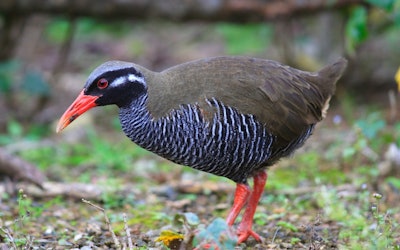
Introducing the Okinawa Rail - A Protected Species in Japan This video, titled “Wild Okinawa rail (Kunigami, Okinawa prefecture) May 11th-12th, 2019(野生の ヤンバルクイナ (沖縄県国頭村) 2019年5月11-12日) introduces the Okinawa rail, a protected species on the Red List of the Ministry of the Environment. The Okinawa rail is also a critically endangered species and a Specified National Endangered Species of Wild Fauna and Flora. They are flightless birds and live only in Okinawa. This video was taken in 2019 on the street in Kunigami, Okinawa prefecture. The bird is an endemic species found only in northern Okinawa prefecture, Kunigami, Ogimison, and Higashison, and is referred to as "Yanbaru." It's a very rare bird, not only in Japan but also around the world. The forest area located in the northern part of Okinawa is called the Yanbaru Forest. Kunigami Village, where wild Okinawa rail (Yanbaru Kuina) appear frequently, is called the Forest of Kuina. There is an Okinawa Rail Ecology Center, and the Yanbaru Kuina observatory is located there. The Ecology of the Okinawa Rail Photo:Okinawa rail The wild Okinawa rail is characterized by the following morphology and characteristics: ・Birds, Order Gruiformes, Family Rallidae, scientific name: Gallirallus okinawae ・Size: approx. 35 cm in length with a weight of 230 gramst ・Wild distribution:The woodlands near Mt. Yonahatake ・Eating habits:Omnivorous ・Nesting:They build nests on the grounds of the forest, and lay about 4 eggs in breeding season. ・They have vestigial wings and are unable to fly, but parent birds have bright red bills and beautifully striped feathers. Chicks have a protective coloring of deep black feathers. ・Their calls are distinctive, and very loud. The Origins of the Name "Yanbaru Kuina," and the History the Okinawa Rail Photo:Okinawa rail The first discovery of the wild Okinawa rail by experts was in 1981, which is actually quite recent. There are various kinds of Rallidae (rails) around the world, but it gained a lot of attention as the first rail species to be discovered in the wild. In Okinawa Prefecture, they were called by different names such as Agachi, Agacha, and Yamadui, depending on the region, and it turned out that they are a species indigenous to the region with a long history. Therefore, they were named Yanbaru Kuina from Yamadui, which means bird of the mountains, using the Kanji "山原"as a phonetic equivalent (pronounced Yanbaru in Okinawa dialect). Other than Yanbaru Kuina, Yanbaru Fumiru and Okinawa Kuina were other possible names. Summary of Very Rare Okinawa Rail Photo:An Okinawa rail crossing sign The Okinawa rail is an endangered species of wild bird that can only be seen in Yanbaru Forest on the main island of Okinawa. Even in Okinawa Prefecture, you cannot see them on remote islands such as Miyako Island. They are a very rare endemic species. The reasons for the decline in the Okinawa rail's population are due to deaths from car accidents and attacks by alien predators such as mongooses, Yellow fever mosquitoes, and stray cats. At 0:10 in the video, an Okinawa rail is seen crossing the road at a brisk pace, raising concerns about traffic accidents. Japan is still an island country with 70% of its land surrounded by forests, and there are many rare wild indigenous species that are only found in Japan, so it is said to be very important for the protection of indigenous species that we do not pollute the natural environment through overexploitation, nor bring dangerous alien species into the country without care. Currently, the Ministry of the Environment is taking the lead in protecting the Okinawa rail, breeding mates, increasing their numbers, and returning them to the wild. However, it is important not only to protect them strictly, but also to make people widely aware of Okinawa rails. In this way there are goods such as stuffed animals sold at roadside stations and airport shops in Okinawa. These awareness raising activities are also part of the important protection policies. -
 Video article 4:48
Mountaineer Ken Noguchi Talks About Environmental Issues. The Climber Who Conquered the Mountains of the World, Now Spends His Time Cleaning up the World Heritage Site Mt. Fuji, With Children.
Celebrities Nature- 209 plays
- YouTube
The Cool Choice Project The Cool Choice Project is an educational activity that was launched in 2015 to introduce the efforts of the Ministry of the Environment to tackle global warming and call on all people to help fight global warming caused by carbon dioxide. Ken Noguchi, a world-famous, professional mountaineer, and the youngest person to climb the Seven Summits, talks about COOL CHOICE in a video interview titled "Our COOL CHOICE: Mountaineer Ken Noguchi|COOL CHOICE" (私たちができるCOOL CHOICE 登山家 野口健|COOL CHOICE). Who Is Ken Noguchi? Source :YouTube screenshot Maybe the profile of the alpinist (professional mountaineer) Ken Noguchi is more appropriate than the mountaineer Ken Noguchi. Mountaineer Ken Noguchi- No, scratch that, PROFESSIONAL mountaineer Ken Noguchi, was born in Boston, Massachusetts, to a Japanese diplomat father and an Egyptian mother. He first came to Japan when he was four years old, and at first, wasn't able to speak any Japanese. His parents also divorced when he was in elementary school. When he was suspended from high school, he received a copy of "Risking My Youth on the Mountains" by mountaineer Naomi Uemura and had his first mountain climbing experience. Even when he was unsure of what to do after graduating from high school, this book inspired him to enroll in Asia University with the goal of conquering the Seven Summits. Ken Noguchi is currently married, with a wife and daughter. It became a hot topic on a TV variety show when it was revealed that he and his wife had lived apart for 15 of their 16 years of marriage and that he had set up a separate house in Otsuki, Yamanashi Prefecture, far from his home, and that even when he was in Japan, he stayed there. His daughter, Eko Noguchi, is a TV personality and mountaineer that does mountain climbing activities with her father. You can find more information about Ken Noguchi and his daughter on Twitter and blog, so if you're interested, be sure to follow him. Source :YouTube screenshot Ken Noguchi Profile ・ Height 169 cm (5'6") ・ Blood type A ・ Alpinist (professional mountaineer) and t.v. personality ・ Visiting Scholar, Asia University -Biography- ・ Climbed Mont Blanc, the highest peak in the European continent, at the age of 16. ・ At the age of 17, climbed Mt. Kilimanjaro, the highest peak on the African continent. ・Set the record for the youngest person to climb Mt. Everest at the age of 25. ・ Established the Sherpa Fund for Sherpa orphans who died in 2000 ・ Established the Manaslu Fund in 2006 to support children's education in Sama Village ・ Currently engaged in cleaning and climbing the Himalayas and Mt. Fuji as a representative of NPO PEAK + AID Environmental Protection Message From Mountaineer Ken Noguchi Source :YouTube screenshot At 1:00 in the video, Noguchi talks about his reasons for wanting to clean up the environment. A truly admirable task. When climbing Everest for the first time, he noticed there was a lot of garbage, some of which had Japanese writing on it. According to the Sherpas, Mt. Fuji is famous for being one of the most trash-filled mountains in the world, and the Japanese climbers are considered a nuisance because they just kept littering. Hearing this, Noguchi's ego as an alpinist began to change. From 2:38 in the video, Noguchi says, "Above all, it's important to understand our impact on nature." Without mountains, there'd be no mountaineering. Understanding this, Noguchi desired to keep clean the mountains that he treasured so. If you love the sea, you clean the sea. The first thing to do is to discover a connection with nature, even if it's subjective, just wanting to clean the place that you love, that's a start. Summary of Professional Climber Ken Noguchi Source :YouTube screenshot In addition to his work as a mountaineer, Ken Noguchi also focuses on environmental education and organizes classes to clean up mountains around Japan, including Mount Fuji. You can see some of his activities at 2:44 in the video. We hope you take a look at Mr. Noguchi's interview and think about your own impact on the environment. 【Official Website】Ken Noguchi Official Website http://www.noguchi-ken.com/ -
Video article 5:35
Feel the Grandeur of Nature in Futtsu City, Chiba Prefecture! Beautiful Natural Scenery Through Realistic Drone Footage of Insta-Worthy Spots!
Local PR Travel- 219 plays
- YouTube
日本の観光スポット「千葉県富津市」の動画について 千葉県富津市は太平洋に面した場所で、雄大な海を観賞できるスポットです。 いくつものおすすめの鑑賞エリアがあり、それぞれで特徴的な景色を楽しめます。 富津岬は東京湾内を一望できる人気の鑑賞スポット。 絶好のロケーションでみなとみらいや三浦半島まで見渡せます。 富津岬のおすすめのスポットが明治百年記念展望塔。 遠くまで見渡せる東京湾の絶景に心奪われるでしょう。 動画では0:35から紹介されています。 海水浴場として人気の場所が新舞子海岸。 動画の1:44から紹介されています。 どこまでも続く広い砂浜と開放的な雰囲気が特徴の海岸です。 また、新舞子海岸は釣り場としても人気で、堤防の上からのんびり釣りをするのもおすすめ。 富津市の雄大な海を見られるスポットは他にも、磯根崎や上総湊海水浴場、富津海岸、東京湾フェリー、東京湾観音などがあります。 千葉県の人気観光スポット「千葉県富津市」で自然を感じる 千葉県富津市には海以外にも自然の景観を楽しめるスポットがたくさんあります。 動画の1:07から紹介されているマザー牧場は豊かな自然と触れ合うことができる大人から子どもまで楽しめる施設です。 美しい花々や広大な牧場の中で育つ動物など見どころがいっぱい。 綺麗な空気の中で動物たちと触れ合い、心が癒やされる貴重な体験になるでしょう。 燈籠坂大師の切通しトンネルは、古代遺跡のような雰囲気を楽しめるスポット。 光と影の幻想的な景勝が見られます。 動画では3:37より紹介されています。 他にも湊川上流や鋸山ロープウェー、岩谷堂やぐら群、富津公園、高宕山自然動物園などもおすすめのスポット。 千葉県の人気観光スポット「千葉県富津市」で人気のアクティビティ 千葉県富津市は自然豊かで、海水浴、ゴルフ、釣り、ハイキング、潮干狩りなどのアクティビティが人気です。 また、富津市民の森キャンプ場で綺麗な星空を見ながらのキャンプや天然温泉海辺の湯でゆったり温泉につかるのもおすすめ。 さらに富津市民花火大会で花火を楽しんだり、金谷美術館で日本の芸術品に触れれば、とても充実した旅行となるはずです。 千葉県の人気観光スポット「千葉県富津市」紹介記事のまとめ 日本の観光名所である千葉県富津市。 雄大な日本の海を楽しむのもよし、牧場で動物に触れ合うのもよし、釣りやキャンプなどのアクティビティを体験するのもよしとさまざまな楽しみ方があります。 富津市の自然に癒やされパワーをもらいましょう。 -
Video article 4:07
The Pristine Sandy White Beaches and Emerald Green Waters of Yoron Island in Kagoshima Prefecture... Beautiful Natural Scenery, History, Culture, and Local Food Come Together to Create Something Amazing!
Travel- 100 plays
- YouTube
美しき海が堪能できる「与論島」紹介動画について こちらの動画は「Yoron Island Japan」が公開した「Yoron Island Japan in 8K HDR - 与論島」です。 突如出現する、幻の白い浜。 南国のどこかを想像させるハイビスカスは、潮風に揺らされ、大自然のなかで鮮やかに咲き誇ります。 8K動画でご覧になれるのは、鹿児島県にある「与論島」。 日本にいることを忘れてしまうほどの景観を持つ、日本でも有数の癒しスポットです。 与論島ってどんな観光スポット? 与論島とは、奄美諸島最南端にある、自然豊かな島です。 亜熱帯気候で、ダイビングや海水浴などの海のレジャーが盛んです。 サンゴ礁が隆起してできた与論島は砂浜が白く、条件が揃ったときのみ現れる「百合ヶ浜」は、日本内外の観光客に人気があります。 サンゴは他にも、コーラルウェイとういう白い一本道を作り、地下では景勝地の赤崎鍾乳洞を作り上げました。 豊かな自然には多くの生き物たちが暮らし、トゥイシ海岸はウミガメの産卵地にもなっています。 与論島は、特産物のもずくの他、マンゴー、伊勢エビなどグルメも充実。 茶花漁港の魚市場では、伊勢エビを筆頭に、南国の新鮮な魚介類をご覧になることができます。 自然の恵みを思う存分堪能しましょう。 日本でも珍しい文化を持つ与論島 与論島は沖縄県に近いため、琉球と薩摩の文化が融合され、日本のなかでも独自の文化が発展しました。 かつて琉球国王に仕えた武術の達人、按司根津栄(アジニッチェー)を祀る按司根津栄神社は、沖縄との文化交流の歴史を裏打ちします。 また、与論島の伝統芸能である「与論十五夜踊り」は、琉球と薩摩の文化の特色があり、国の重要無形民俗文化財に指定されています。 観光名所である「与論民族村」では、芭蕉布織りの体験を通して、与論島の暮らしや文化に触れることができます。 与論島には、海岸ごとに異なった魅力がある 与論島の海岸は、ひとつひとつに異なった景色があり、楽しみ方もそれぞれです。 例えば、与論島最大のビーチである大金久海岸は、キャンプ場を併設。家族や連れや団体客で賑わうビーチです。 潮干狩りができる前浜海岸からは、沖縄本島を望むことができます。 プライベート感を味わいたいなら寺埼海岸や宇勝海岸へ。 さざなみに自然と心癒される、旅行の穴場です。 カップルにおすすめなのは兼母海岸。 周辺のホテルのプリシアリゾートでは、マジックアワーとともにバーベキューを楽しむことができます。 イチャジキ浜も訪れてみましょう。 満点の星空が絶景で、ここは日本ではない、楽園のようです。 美しき海が堪能できる「与論島」紹介まとめ 与論島には、竜宮岩、ビーチリングなどのインスタ映えスポットも多数点在! 豊かな自然と文化、日本が誇るリゾートの情報は、この動画でチェックです! -
Video article 4:52
Introducing the Popular Family-Friendly Takenohama Beach! Enjoy the Crystal Clear Waters of Toyooka, and Spectaculars Views of the Ocean and Mountains!
Nature- 74 plays
- YouTube
This video, titled "Japan - Aerial Shot - Takeno Beach ・ 日本 - 竹野浜ビーチ," was released by "Taru Farias - Japan Travel." In the video, you can see Takenohama Beach at the sea in Toyooka in Hyogo Prefecture. The sea at Toyooka is clear and blue even from the sky, and it is crowded with many swimmers. The view from the nearby mountains is also superb. Be sure to check it out in the video! -
Video article 6:34
Unkai Terrace - Experience a Sea of Clouds Flowing Like the Ocean! Powerful Views You Won't Find in Everyday Life. It's Truly a Sight to Behold!
Nature- 88 plays
- YouTube
This video, titled "[Hoshino Resort Tomamu] Unkai Terrace - Sea of clouds flowing into the sea of clouds (Unkai Terrace)" (【星野リゾート トマム】雲海テラス 流れ込む雲海<絶景> Unkai Terrace), was released by Hoshino Resort Tomamu (official). This video introduces Unkai Terrace at the luxury resort "Hoshino Resort Tomamu" in Hokkaido. Unkai Terrace is a superb spot at the Hoshino Resort Tomamu in Hokkaido where you can see the sea of clouds from above, and the overwhelming view of the grandeur of nature is nothing short of breathtaking. The probability of seeing the sea of clouds itself is low, but it is a view that makes you want to see it at least once in person. This video shows the actual view of the sea of clouds from Unkai Terrace, so if you're interested, be sure to check it out. -
Video article 11:06
What to Do in Tomakomai in a Day, 30 Minutes from the Airport
Travel Nature Local PR- 20 plays
- YouTube
■Contents Introduction Why Tomakomai Is Chosen as a Base for a Hokkaido Trip A Port Town Where the Gateways of Air and Sea Overlap Major Spots Divided Between the Airport Side and the City Center Why Tomakomai Has So Many Places You Can Enter for Free A One-Day Model Itinerary for Tomakomai Start the Morning With the Lake and the Observation Deck Head for the Space Station and the Port Photo Spot in the Afternoon Travel Times Until Evening and How to Rearrange the Plan The Lake and Airplane Views at Michi-no-Eki Utonai-ko An Observation Deck With a 360-Degree View From the Rooftop Walking the Nature Trail Along the Shore Local Seafood and Regional Goods Inside the Building Michi-no-Eki Utonai-ko Basic Information Inside a Space Station at the Mir Exhibition Hall Why There Is a Backup Unit of Mir in Tomakomai What You Can See Inside, From Control Panels to Living Quarters Enjoying the Planetarium and the Main Exhibition Room Too Tomakomai Science Center Basic Information Tomakomai Seen From Two Heights, the Port and the Hill The PORT OF TOMAKOMAI Monument at Kirakira Park Mount Tarumae and the Sea From the Midorigaoka Park Observation Deck The Factory Lights That Emerge After Dark Basic Information for the Two Parks Port Town Flavors and Souvenirs to Try in Tomakomai A Plate of Hokki Clam, the Taste of a Port Town The Soft Serve That Placed at a Grand Prix Choosing Yoitomake and Haskap Sweets at the Mitsuboshi Main Store Basic Information for Each Shop How to Pick a Season When You Cannot Decide When to Go When Can You See Swans Mount Tarumae and the Lakeshore at Their Best in the Green Season Temperature Differences by Season and What to Wear Wider Sightseeing With Tomakomai as Your Base A Half-Day Plan Out to Lake Shikotsu The Route Toward Shiraoi and Noboribetsu Short Plans That Fit Into a Layover at the Airport Getting to Tomakomai and Around the City Traveling From New Chitose Airport by Car, JR or Bus Getting Around After Arriving by Ferry Points to Watch When Getting Around by Public Transportation Frequently Asked Questions About Visiting Tomakomai Can You Visit Tomakomai From New Chitose Airport as a Day Trip Can You Get Around the Sights in Tomakomai Without a Car Are There Places to Enjoy on Rainy or Cloudy Days Can You Fill a Whole Day With Children Along When Can You See Swans at Lake Utonai Ways to Spend a Day in Tomakomai, Chosen by What You Want もっと見る Introduction Hokkaido is the island at the northern end of the Japanese archipelago. Tomakomai, in its southwestern part, sits about 30 minutes by car from New Chitose Airport, and it is also a port town that serves as a gateway by sea, with ferries arriving and departing. Here you will find Lake Utonai, registered under the Ramsar Convention, a real backup unit of the space station Mir, and the view of Mount Tarumae and the ocean from a hill. This article gathers a model itinerary for Tomakomai and the highlights of each spot, based on a route actually covered in a single day. Photo: Tomakomai, Hokkaido / A Pacific port town where greenery, factories and harbor sit side by side Why Tomakomai Is Chosen as a Base for a Hokkaido Trip You may have seen the name Tomakomai on expressway signs or on ferry destination boards without ever getting off and walking around. Tomakomai is a transport hub, easy to reach from New Chitose Airport and served by ferry routes linking ports across Honshu. Photo: Tomakomai West Port Ferry Terminal / Hokkaido's sea gateway, linked by ferry to ports across Honshu A Port Town Where the Gateways of Air and Sea Overlap New Chitose Airport is Hokkaido's gateway by air. From there to central Tomakomai is 22.7 km on ordinary roads, roughly 30 minutes by car. You get there without ever using the expressway, so the afternoon of your arrival day, or the morning of your departure day, turns straight into sightseeing time. The other gateway is the Tomakomai West Port Ferry Terminal. Four routes serve it, running to Hachinohe, Sendai, Nagoya and Oarai, and this is the port where travelers who have crossed from Honshu with their cars first set foot. Few cities in Hokkaido act as an entrance both by air and by sea. If you are coming from overseas, the usual route is to connect to a domestic flight at a major airport such as Tokyo, Osaka or Nagoya and fly into New Chitose Airport. Travel time varies with your point of departure and your flight, so check connection times in the airline timetables. Major Spots Divided Between the Airport Side and the City Center The sights of Tomakomai fall into two broad clusters. The Uenae district, nearer the airport, has Lake Utonai and the roadside station on its shore, while the city center side lines up the Tomakomai Science Center, Kirakira Park by the port, and Midorigaoka Park up on the hill. Because the sights are split between the airport side and the city center side, you can head for the lake first with the airport still fresh behind you, then work your way down into town, and build a day that never doubles back. On a day when you arrive at the port by ferry, follow the same route in reverse and you come out at the airport. Why Tomakomai Has So Many Places You Can Enter for Free Sightseeing in Tomakomai is easy on the wallet. At the Tomakomai Science Center, the main exhibition room, the Mir Exhibition Hall and the planetarium are all free to enter, and the Midorigaoka Park observation deck is free as well. Neither Kirakira Park nor Michi-no-Eki Utonai-ko charges admission. Most of the main spots introduced here are free to enter. A One-Day Model Itinerary for Tomakomai Before going into what each spot holds, here is the shape of the day as a whole. Each sight is explored one by one from the next section onward. Start the Morning With the Lake and the Observation Deck The first stop of the day is Michi-no-Eki Utonai-ko, on National Route 36. A michi-no-eki is a roadside rest facility you can drop into partway through a journey, where local produce, souvenirs and light meals are also on offer. It opens at 9:00, so if you pick up a rental car at New Chitose Airport and drive straight south, you arrive right around opening time. Here you go up to the rooftop deck to look out over the lake, then walk a short stretch of the trail along the shore. Allowing about an hour for the view and the walk together gives you a pace that never feels rushed. 【Video】2:37〜 The lake and a passenger plane seen from the observation deck at Michi-no-Eki Utonai-ko If you want to browse local products at the shop or grab something light at the food court, add another 30 minutes or so. Head for the Space Station and the Port Photo Spot in the Afternoon After leaving the lake, drive toward the city center and go into the Tomakomai Science Center. It is open from 9:30 to 17:00, so arriving early in the afternoon leaves you time for both the Mir Exhibition Hall and the planetarium. Figure on one hour to an hour and a half for the visit. From there, drop down toward the sea to Kirakira Park. Photograph the monument with the moored ferries behind it and spend around 30 minutes. Finish by going up to the Midorigaoka Park observation deck on the hill, where Mount Tarumae, the city and the ocean all come into view at once. Travel Times Until Evening and How to Rearrange the Plan Travel times within the city change with the route and the time of day. Checking the day's travel times on a map app before you set out keeps the second half of the plan from falling apart. On a day when you only have half a day, narrow it down to two places, the lake and the science center. If photography is your aim, rearranging the day around the port and the hill works well. Time your climb to the Midorigaoka Park observation deck to sunset and you can stay on after the sun has gone down, since it is open until 21:00 from April 20 through October 31. The Lake and Airplane Views at Michi-no-Eki Utonai-ko Many people probably think of Lake Utonai as a place for birdwatching. Stand there, though, and you notice a combination you cannot see anywhere else, created by the closeness of the lake and the airport. Photo: Lake Utonai / A Ramsar-listed wetland for birdwatching, with New Chitose Airport flights crossing overhead An Observation Deck With a 360-Degree View From the Rooftop The building at Michi-no-Eki Utonai-ko has three floors, with an elevator up to the outdoor space on the third. The second floor is an indoor observation room, a place to view the lake through glass. Step outside on the third floor and climb one more flight of stairs to the rooftop deck, and the view opens up a full 360 degrees. What you see, in order, is the parking lot and National Route 36 in the foreground, grassy lakeshore beyond that, and the surface of the lake spreading out at the very back of your line of sight. New Chitose Airport is close by, so you may catch sight of an airliner crossing the far side of the lake as it loses altitude. Flight paths change with the time of day and the wind direction, so there is no guarantee you will see one. Walking the Nature Trail Along the Shore If you want to get down to the water's edge, there is the nature trail of the Wild Bird Society of Japan's Utonai-ko Sanctuary. Observation points are set out along the way, including the Common Sandpiper terrace, the alder terrace, the Greater White-fronted Goose terrace, the grassland observation hut and the barrier-free course, on a route that takes you through woodland, grassland and waterside. Some facilities are currently out of use, so check the latest status before you set out. The path is surfaced with wood chips, so even a short walk leaves you feeling you have been out in the forest. The sanctuary's nature center is open Saturdays, Sundays and public holidays from 9:30 to 16:30. If you visit on a weekday, the neighboring Utonai-ko Wildlife Protection Center serves as the point of contact. It closes every Monday and is open from 9:00 to 17:00. Local Seafood and Regional Goods Inside the Building Inside there is a local products corner and a direct sales counter for farm, forest and marine products, alongside takeout windows where you can eat on the spot. There is a food court too, so on a day when you set out without breakfast, one option is to simply have a meal here. The toilets and the car park are open 24 hours, and inside the building there is a tourist information and luggage counter, a kids' corner where small children can play, and a nursing room. On a day of long-distance driving with small children, this roadside station makes the first rest stop. Michi-no-Eki Utonai-ko Basic Information Michi-no-Eki Utonai-ko 【Address】156-30 Aza-Uenae, Tomakomai, Hokkaido 【Phone】0144-58-4137 【Hours】9:00-18:00 (March-October), 9:00-17:00 (November-February) 【Closed】New Year period (December 31-January 2) 【Admission】Free 【Time needed】1 hour to 1 hour 30 minutes 【Parking】93 standard cars, 10 large vehicles, 2 accessible spaces 【Official Website】Tomakomai City tourist information, "Michi-no-Eki Utonai-ko" ※Prices and opening hours are as of September 2026. Please check the official website for the latest details. Inside a Space Station at the Mir Exhibition Hall A real space station, sitting in a city better known as an industrial town. That fact alone is surprising enough, but what follows is more so. The exhibit is not something you only view from the outside, because you can go inside and look around. COOLJAPANVIDEOS Why There Is a Backup Unit of Mir in Tomakomai Mir was a space station launched by the former Soviet Union. Its core module was launched on February 19, 1986, and observation and experiment modules were added to it one after another. In April 1996 it became the largest space station in history up to that time, and on March 23, 2001 it came down off the coast of New Zealand in the South Pacific, ending 15 years of operation. What stands in Tomakomai is the actual backup unit. Tomakomai received it as a donation from Iwakura Corporation in 1998, and the Mir Exhibition Hall opened the following December, in 1999. It is not the craft that actually went into space, but it is a genuine article built to the same design, so the interior remains exactly as it was. 【Video】5:36〜 Walking through the inside of the Mir Exhibition Hall What You Can See Inside, From Control Panels to Living Quarters Two modules are on display, the core module Mir and the astrophysics observation module Kvant. Mir means peace in Russian, and Kvant means quantum. The core module weighs 20.4 tons and is 13.13 m long, with a pressurized section of 90 cubic meters where people could live, holding the life support system and the power system driven by solar panels. Kvant weighs 11.5 tons and is 5.8 m long, and it carried telescopes, various observation instruments, gyroscopes and an oxygen generator. There are six docking ports on the outside of the craft, where other modules and supply vessels could connect. Go inside and you find a control room lined with automatic control panels, with the living quarters continuing behind it. The private cabin where a cosmonaut slept is about the size of half a tatami mat, and the sleeping bag was fixed to the wall. A toilet and faucet adapted to zero gravity, a shower designed so the water does not fall away, an oven and a refrigerator, and even a treadmill for preventing muscle loss all remain. Standing in front of the real thing, you understand why the same daily life as on the ground had to be provided in a form so unlike it. Enjoying the Planetarium and the Main Exhibition Room Too The same building also holds a planetarium with a dome 10 m across. It has 84 seats, and a projector made by Goto Optical Manufacturing projects about 6,500 fixed stars down to magnitude 6.25. The main exhibition room, the Mir Exhibition Hall and the planetarium are all free. When rain or strong wind wrecks your plans, this facility, which works entirely indoors, is the first place to head for. Tomakomai Science Center Basic Information Tomakomai Science Center (Mir Exhibition Hall) 【Address】3-1-12 Asahicho, Tomakomai, Hokkaido 【Phone】0144-33-9158 【Hours】9:30-17:00 【Closed】Every Monday (the next weekday if Monday is a public holiday), New Year period (December 29-January 3) 【Planetarium screenings】Twice a day on weekdays, at 14:00 and 15:30; three times a day on Saturdays, Sundays, public holidays and the spring, summer and winter school holidays, at 11:30, 14:00 and 15:30. Each screening seats 40, with priority given to advance bookings. Reservations open the month before the screening date, and same-day booking is also possible 【Admission】Free (main exhibition room, Mir Exhibition Hall and planetarium all included) 【Time needed】1 hour to 1 hour 30 minutes 【Parking】Free. 20 cars, 4 large buses (large buses must contact the center in advance) 【Official Website】Tomakomai Science Center ※Admission and opening hours are as of September 2026. Screenings are suspended on some days for maintenance, so please check the official website for the current schedule. Tomakomai Seen From Two Heights, the Port and the Hill So far we have looked at the lake and at indoor exhibits, but Tomakomai offers one more pleasure, that of looking at the city itself. A quay close to sea level, and a hill overlooking the built-up area. Even in the same city, what you see changes with where you stand. Photo: Kirakira Park / A photo spot backed by the port, its base inscribed PORT OF TOMAKOMAI The PORT OF TOMAKOMAI Monument at Kirakira Park Kirakira Park is the popular name for a green space on the north wharf of Tomakomai Port. It appears in the city's list of parks under the name Kitafuto Ryokuchi, or North Wharf Green Space, and it was laid out as part of the redevelopment of the port. In 2011 it received national certification as a "Minato Oasis." If you are visiting to take photographs, the target is the PORT OF TOMAKOMAI monument, installed to mark the 60th anniversary of the opening of Tomakomai Port. The lineup runs from a lawn in the foreground to the quay beyond it, with moored ferries and the factories on the far shore at the back of the view. 【Video】7:31〜 The monument and a large ferry berthed at the port The park also has combination play equipment, a wading pool and a zip line, so families with children can pass the time on the playground. Mount Tarumae and the Sea From the Midorigaoka Park Observation Deck Midorigaoka Park, spreading across the north side of the city center, is a sports park covering 87.0 ha. The observation deck standing in one corner of it was built in 1998 to mark the 50th anniversary of Tomakomai's founding as a city. An elevator takes you up to the viewing level. What you see from here is the park's trees and the rooftops of the city in the foreground, the chimneys of the Oji Paper Tomakomai mill and the port beyond them, and the foothills of Mount Tarumae and Mount Fuppushi stretching out on the opposite side. Mountains, city and sea line up in a single field of view. 【Video】9:59〜 Mount Fuppushi and the mill chimneys seen from the viewing level Opening hours switch with the season, running from 9:00 to 21:00 between April 20 and October 31, and from 10:00 to 18:00 between November 1 and April 19. Days are long in summer, so even if you go up in the evening you can enjoy the scenery while it is still light. The Factory Lights That Emerge After Dark Tomakomai is also a city of paper manufacturing and petrochemicals, and after sunset the plants along the coast light up. The Midorigaoka Park observation deck closes at 21:00 in summer, so you can go up in the hours after the sun has set. If night views are your goal, build your plan by lining up that day's sunset time with the deck's closing time. In winter it closes at 18:00, so from November through April the short window just after sunset is the one to aim for. Basic Information for the Two Parks Kirakira Park (Kitafuto Ryokuchi) 【Address】3-1 Irifunecho, Tomakomai, Hokkaido 【Phone】0144-34-5551 (Tomakomai Port Authority) 【Open】Always open 【Closed】None 【Admission】Free 【Time needed】30 minutes 【Parking】About 70 standard cars 【Official Website】Tomakomai Port Authority, "Kirakira Park" Midorigaoka Park Observation Deck 【Address】1 and 3 Chome Shimizucho and Aza-Takaoka, Tomakomai, Hokkaido 【Phone】0144-33-6933 (Midorigaoka Park management) 【Open】9:00-21:00 (April 20-October 31), 10:00-18:00 (November 1-April 19) 【Closed】First Monday of the month (April 20-October 31), every Monday (November 1-April 19). New Year period (December 31-January 2) 【Admission】Free 【Time needed】30 minutes 【Parking】8 lots across the whole park, 931 spaces in total 【Official Website】Tomakomai City, "Midorigaoka Park" ※Admission and opening hours are as of September 2026. Please check the official websites for the latest details. Port Town Flavors and Souvenirs to Try in Tomakomai Once you have made the rounds of the scenery, food and souvenirs are the next thing on your mind. Tomakomai has flavors that could only come together in this city. Photo: Yoitomake, a Tomakomai specialty / Mitsuboshi's signature cake, haskap jam swirled inside and coating the outside A Plate of Hokki Clam, the Taste of a Port Town No account of Tomakomai is complete without hokki clam, the Sakhalin surf clam. In Japan it is a familiar type of bivalve, eaten either raw or cooked. According to materials from the city of Tomakomai, the annual catch is around 800 tons, said to be the largest of any municipality in Japan. The figure for 2024 (Reiwa 6) was about 750 tons. On Marine Day, July 20, 2002, it was also designated the city's official shellfish. Behind those numbers lies years of resource management. Only large clams with a shell length of 9 cm or more are landed, and the spawning season from May to June is a closed period for fishing. Restaurants around the city use hokki clam in a wide range of dishes, from sushi to curry to ramen, and comparing how each place serves it is a pleasure in itself. The Soft Serve That Placed at a Grand Prix Shiawase no Nama Soft Petit Lapin, in Misonocho, took second place at the first Hokkaido Soft Serve Grand Prix. It has moved from Shirakabacho and is takeout only, with no seating inside. Its signature item, the "shiawase no nama soft," is made with select fresh cream from pasture-raised cows in eastern Hokkaido. In summer, seasonal items using haskap, which grows wild on the Yufutsu Plain, join the menu. Slotting a stop in between your time in the city center and the observation deck makes for a well-timed break. Choosing Yoitomake and Haskap Sweets at the Mitsuboshi Main Store For souvenirs, head to the main store of Mitsuboshi in Itoi. This confectionery maker was founded in 1898, in the 31st year of the Meiji era. Its signature product, Yoitomake, is a rolled castella that went on sale in 1953, castella being a sponge-style baked cake. This sweet is wrapped on the outside in haskap jam. Alongside the standard haskap version, the store also carries a lemon flavor, a related product called Nanakamado, and cakes. The name comes from the call workers used when raising and lowering logs at the timber yard of the paper mill. Haskap is a shrub of the honeysuckle family that grows wild on the Yufutsu Plain and bears dark purple berries in summer. The name comes from the Ainu word "hasikap," meaning something that grows in abundance on the branches. The Ainu are the Indigenous people who have lived in Hokkaido and northern Japan since ancient times. The main store is open from 8:00 to 19:00 with no closing days, so you can fit it in before a ferry departure or during an early morning drive. 【Video】0:31〜 Tasting Yoitomake and Nanakamado side by side Basic Information for Each Shop Mitsuboshi Main Store 【Address】141 Itoi, Tomakomai, Hokkaido 【Phone】0144-74-5221 【Hours】8:00-19:00 【Closed】Open year-round 【Prices】Vary by product 【Time needed】20 to 30 minutes 【Parking】Available 【Official Website】Mitsuboshi (Yoitomake) Shiawase no Nama Soft Petit Lapin 【Address】2-3-22 Misonocho, Tomakomai, Hokkaido 【Phone】080-3537-5025 【Hours】11:00-20:00 (closes at 18:00 on machine maintenance days) 【Closed】Irregular 【Prices】Please check with the shop 【Time needed】20 minutes 【Parking】Available on site 【Official Website】Shiawase no Nama Soft Petit Lapin ※Prices and opening hours are as confirmed in September 2026. Petit Lapin has only just moved to Misonocho, so please check its official social media for opening hours, closing days and prices. How to Pick a Season When You Cannot Decide When to Go Tomakomai is a city where what you see changes dramatically with the season. What you are coming for decides which time of year to choose. Photo: Lake Utonai in winter / A birdwatching site in Tomakomai where whooper swans appear even when the lake freezes When Can You See Swans Lake Utonai became a nationally designated wildlife protection area in 1982, and in 1991 it became Japan's fourth wetland registered under the Ramsar Convention, an international treaty aimed at conserving wetlands. The number of bird species recorded is given as about 270 both in the city of Tomakomai's nature information and on the official website of Michi-no-Eki Utonai-ko, and as more than 260 in Ministry of the Environment materials. Swans are easiest to see during the migration seasons. According to observation records kept by the city of Tomakomai, Whooper Swans are frequently seen from December through March, and Tundra Swans in November and from February through April. Greater White-fronted Geese center on September through November and February through April. In spring, the period up until they fly north in early April is when the lake is at its busiest. Arrival timing shifts earlier or later depending on the year's weather, so check the current situation in the nature updates for that year from the Utonai-ko Wildlife Protection Center or the Wild Bird Society of Japan sanctuary before you set out. Mount Tarumae and the Lakeshore at Their Best in the Green Season From summer into early autumn, the species you can spot differ from those of the spring and autumn migrations, and the greenery around you deepens. The foot of Mount Tarumae as seen from the Midorigaoka Park observation deck also looks sharpest at this time of year. Long days, plus a deck that stays open until 21:00, make up another reason to choose summer. Temperature Differences by Season and What to Wear According to Japan Meteorological Agency normals for 1991 to 2020, the monthly average temperature in Tomakomai is minus 3.6°C in January and 20.4°C in August, with an annual average of 7.9°C. May averages 10.0°C and October 11.5°C, so for spring and autumn, plan on one more layer than you would in Honshu. On the day of the visit in early May, the sky was overcast and the temperature was around 15°C, cool enough to want a jacket. Even in summer it stays around 20°C, so bring a light layer to throw on even for an August visit. In winter it drops to around minus 3°C, and there is nothing to block the wind at the port or on the observation deck. Along with warm outerwear, you will need gloves and shoes with good grip. Wider Sightseeing With Tomakomai as Your Base You have spent a day in Tomakomai, and you have another half day to spare. On days like that, the destinations are waiting in this city. Photo: Shiraoi, Hokkaido / The National Ainu Museum at Upopoy, its walls set with Ainu patterns A Half-Day Plan Out to Lake Shikotsu Head north from central Tomakomai on National Route 276 and you reach Lake Shikotsu after about 25 km, roughly 30 minutes by car. The lake is known for the clarity of its water, and the shore is equipped with walking paths and a visitor center. Public transportation is the thing to watch. According to information from the Lake Shikotsu Visitor Center, there are no scheduled bus routes to Lake Shikotsu from Sapporo or Tomakomai. To get there by bus, use the Hokkaido Chuo Bus "Sora 4 Lake Shikotsu Line." It runs from New Chitose Airport with no transfer and takes about an hour, calling at Minami-Chitose Station and Chitose Station on the way. The Route Toward Shiraoi and Noboribetsu Follow the coast west and you come to Upopoy, the National Ainu Museum and Park, in the town of Shiraoi. From the Tomakomai West Port Ferry Terminal it is 26 km via National Route 36. This national facility deals with Ainu culture, and between the museum and the traditional kotan outdoors it takes about half a day to see. A kotan is the Ainu word for a settlement or village. Continue west and you reach Noboribetsu Onsen. Onsen, bathing in naturally heated hot spring water, is a distinctly Japanese bathing culture. Note that many hot spring facilities decline entry to people with tattoos. Please check with each facility. From Tomakomai it is about 25 minutes by JR limited express and about 45 minutes by local train, so it fits into an itinerary without a car as well. Leaving Tomakomai in the morning and spending the afternoon in Noboribetsu is a realistic plan. Short Plans That Fit Into a Layover at the Airport If you have a few hours to spare at New Chitose Airport, there are options that do not involve going far. Northern Horse Park, 15 minutes from the airport by car, has 500 free parking spaces and a free shuttle bus running to and from the airport. Michi-no-Eki Utonai-ko is also in Uenae, on the airport side, so another way to use the time is to stop by before returning your rental car, take in the lake from the rooftop deck, and then head back to the airport. Getting to Tomakomai and Around the City Now that we have gone through the sights, here is a summary of how to get there. This city has two gateways, so which one you enter by decides your first move. Traveling From New Chitose Airport by Car, JR or Bus By car it is 22.7 km on ordinary roads such as National Route 36, roughly 30 minutes. You arrive without using any toll roads, so you can drive into the city as soon as you pick up a rental car. If you use JR (Japan Railways), Japan's main railway operator, there is no direct train from the airport to Tomakomai. From New Chitose Airport Station you transfer at Minami-Chitose Station and take the Chitose Line to Tomakomai Station. It takes about 30 minutes, costing 700 yen on a local train. A limited express carries an additional charge, so please check the latest fares on the JR Hokkaido official website. For those who would rather avoid a transfer, there is the Donan Bus Chitose Airport Line. It links New Chitose Airport with the area in front of Tomakomai Station in 1 hour 5 minutes, and the fare is 630 yen one way. There are 13 services on weekdays. Getting Around After Arriving by Ferry The Tomakomai West Port Ferry Terminal is in Irifunecho, the same district as Kirakira Park. The Hachinohe route is operated by Kawasaki Kinkai Kisen with four sailings a day, taking 7 hours 30 minutes to 8 hours 30 minutes. The Sendai route is run daily by Taiheiyo Ferry and takes about 15 hours, while the Nagoya route, also Taiheiyo Ferry, runs every other day, taking about 39 hours 30 minutes from Tomakomai to Nagoya and about 40 hours from Nagoya to Tomakomai. The Oarai route is operated by MOL Sunflower six days a week and takes 18 hours to 19 hours 15 minutes. If you have brought your car with you, you can move straight into sightseeing in the city after disembarking. Foot passengers should check in advance how to get from the terminal to the city center, matching the times of their arriving sailing. Points to Watch When Getting Around by Public Transportation The Tomakomai Science Center is a 20-minute walk from JR Tomakomai Station. Using the Donan Bus it is a 4-minute ride plus a 3 to 5 minute walk, and the nearest stops are "Hoken Center" and "Shiyakusho-mae." Michi-no-Eki Utonai-ko, on the other hand, is some way from Tomakomai Station. The Midorigaoka Park observation deck is about a 30-minute walk from the north exit of Tomakomai Station according to its official guide. If you are getting around by public transportation alone, build a half-day plan around the science center and the restaurants in the city center. Visitors from overseas who want to rent a car need an International Driving Permit. Japan uses left-hand traffic, so anyone coming from a country that drives on the right should take particular care. From around November to March there is snow and ice on the roads, so choose a car fitted with studless tires, or confirm with the rental company whether winter equipment is included. Frequently Asked Questions About Visiting Tomakomai Here are the questions that tend to come up just as you are finalizing an itinerary, gathered in one place. Can You Visit Tomakomai From New Chitose Airport as a Day Trip? Yes. It is about 30 minutes from the airport on ordinary roads, so on an itinerary that leaves the airport in the morning and returns in the evening you can cover all four places, the lake, the science center, the port and the observation deck. It is also possible to build a half-day plan using only the afternoon of your arrival day or the morning of your departure day. Can You Get Around the Sights in Tomakomai Without a Car? Some of them, yes. The Tomakomai Science Center is a 20-minute walk from JR Tomakomai Station, or a 4-minute ride on the Donan Bus plus a few minutes on foot. Michi-no-Eki Utonai-ko has the Utonai-ko stop on the Donan Bus Chitose Airport Line 30, and Midorigaoka Park has the Sogo Undo Koen and Shiritsu Byoin stops on the Donan Bus. Services are not frequent, though, so allow extra time when you plan. Are There Places to Enjoy on Rainy or Cloudy Days? At the Tomakomai Science Center, the main exhibition room, the Mir Exhibition Hall and the planetarium are all indoors, and admission is free on top of that. The second floor of Michi-no-Eki Utonai-ko is an indoor observation room as well, so you can look out over the lake through the glass. When the weather turns, rebuild the day around these two places. Can You Fill a Whole Day With Children Along? Kirakira Park has combination play equipment, a wading pool and a zip line, so you can work in time for running around. Michi-no-Eki Utonai-ko has a kids' space and a nursing room, and the science center's planetarium has 84 seats, making it a place to sit down regardless of the weather. Another point in its favor is that many facilities are free, so costs do not balloon as the group grows. When Can You See Swans at Lake Utonai? According to observation records kept by the city of Tomakomai, Whooper Swans are frequently seen from December through March, and Tundra Swans in November and from February through April. In spring, the season runs until they migrate north in early April. The timing shifts from year to year, so check the nature updates from the Utonai-ko Wildlife Protection Center or the Wild Bird Society of Japan sanctuary for that year's situation before you head out. Ways to Spend a Day in Tomakomai, Chosen by What You Want Even within the same single day in Tomakomai, what you are after changes how you put it together. If you want a day centered on nature, give the morning generously to Michi-no-Eki Utonai-ko and the trail along the shore, then spend the afternoon looking at Mount Tarumae from the Midorigaoka Park observation deck. Time it to the migration seasons and the number of birds on the lake is on another level entirely. With children along, the two anchors are the science center and Kirakira Park. Allow an hour and a half for the Mir Exhibition Hall and the planetarium, and an hour at the park with the play equipment. Neither costs anything, and being able to cut things short when everyone tires out helps. If you want photographs, work backward from sunset. Shoot the monument and the ferries at Kirakira Park, then go straight up to the Midorigaoka Park observation deck and wait for the hour when the city lights and the glow of the factories come into the frame. Admission and opening hours can change. Checking the day's operating status on the Tomakomai Tourist Association site or the official sites of each facility before you visit also makes it easier to rearrange things on the day. If your Hokkaido itinerary still has half a day open in it, why not give that time to Tomakomai. 【Official Website】https://www.tomakomai-kanko.jp/ .text-bold { font-weight: bold; } .caption-heading-2 { font-weight: bold; font-size: 1.7rem; margin-bottom: 15px; max-width: 800px; margin-left: auto; margin-right: auto; } .mod-article-caption .caption-text { margin-bottom: 40px; } .caption-information-table { background-color: #efefef; margin-top: -20px; margin-bottom: 50px; padding: 20px; border-radius: 8px; width: 90%; margin-left: auto; margin-right: auto; } .caption-information-table.blue { background-color: #fffaef; } .caption-information-table .title { font-weight: bold; font-size: 1.7rem; } @media screen and (max-width: 1024px) { .caption-information-table { width: 95%; padding: 30px 15px 30px 15px; } } .caption-heading-table .caption-text li { line-height: 2.5rem; margin-top: 1.3rem; } .mod-article-caption .caption-heading { position: relative; border-left: 5px solid #ff1300; padding-left: 10px; margin-top: 60px; } .mod-article-caption .caption-text { margin-bottom: 50px; } .mod-article-caption .caption-heading-table { width: 95%; padding: 30px 15px 1px 15px; margin-left: auto; margin-right: auto; } .caption-heading-table ul { counter-reset: listnum; list-style: none; font-size: 1.5rem !important; margin-bottom: 15px; } .caption-heading-table ul.list-style-number-jp>li { margin-left: 1.1em; text-indent: -1.1em; font-weight: bold; } .caption-heading-table ul.list-style-number-jp>li::before { counter-increment: listnum; content: counter(listnum) ". "; } .list-style-dot>li::before { content:"↓ "; } .list-style-dot>li { padding-left: 1.8rem; margin-left: 1.1em; text-indent: -1.1em; line-height: 2rem !important; margin-top: 1rem !important; } .separation_line { border-width: 0 0 8px; border-style: solid; border-image: url('data:image/svg+xml,') 0 0 100% repeat; width: 216px; margin: auto; margin-bottom: 50px; } .line-height-text { line-height: 3.7rem !important; } .readMoreContainer { position: relative; height: auto; max-height: 300px; overflow: hidden; transition: max-height 0.6s; } .readMoreContainer::after { content: ""; position: absolute; top: 0; left: 0; z-index: 0; display: block; width: 100%; height: 100%; transition: 1s; background: linear-gradient(to bottom, transparent 40%, #efefef 100%); pointer-events: none; } .readMoreContainer.show:after { z-index: -1; opacity: 0; } .readMoreBtn { display: block; margin: 0 auto; padding: 8px 40px; border: 0; color: #ffffff; background-color: #ff1300; cursor: pointer; border-radius: 5px; margin-bottom: 20px; } .readMoreBtn:hover { opacity: 0.7; } const readmore = document.querySelectorAll('.readMoreInner'); Array.from(readmore).forEach(function(more){ const btn = more.querySelector('.readMoreBtn'); const content = more.querySelector('.readMoreContainer'); btn.addEventListener('click', () => { if(!content.classList.contains('show')){ content.style.maxHeight = content.scrollHeight + 'px'; content.classList.add('show'); btn.innerText = '閉じる'; } else { content.style.maxHeight = '300px'; content.classList.remove('show'); btn.innerText = 'もっと見る'; window.location.href = "#readMoreBlock"; } }); }); { "@context": "http://schema.org", "@type": "WebPage" } -
Video article 2:59
Autumn Leaves at Musashi Kyuryo National Government Park. Enjoy, Seasonal Flowers, Nature, and Exercise With Your Family at Japan's First National Park, Located in Saitama Prefecture!
Nature Travel Art & Architecture- 213 plays
- YouTube
Autumn Leaves at Musashi Kyuryo National Government Park: Video Introduction This video, titled "[Official] Autumn Foliage at Musashi Kyuryo National Government Park" (【公式】国営武蔵丘陵森林公園 園内の紅葉の様子), was uploaded by "Musashi Kyuryo National Government Park" (国営武蔵丘陵森林公園). The video features aerial footage taken via drone showing the beautiful autumn leaves of Musashi Kyuryo National Government Park. The mascots Shin-kun and Rin-chan, as well as a pirate ship, welcome visitors at the central entrance plaza, and from there they pass through Yamada Onuma Pond, where many birds gather, to the beautifully colored maple garden, followed by an installation with beautiful artwork made of bamboo and wood, created by the Sogetsu School of Ikebana. The beautiful 3-minute video is sure to captivate. Be sure to check out the video before reading further! Attractions & Things to Do at Musashi Kyuryo National Government Park Photo:Activities at Musashi Kyuryo National Government Park Musashi Kyuryo National Government Park, Japan's first national park, was developed in Hiki Hills (比企北丘陵) in Saitama Prefecture as part of the Meiji Centennial Anniversary Temple Project. Its vast site approximately 755 acres. In addition to the magnificent natural beauty of the park, visitors will enjoy Pompoko Mountain, the largest outdoor trampoline in Japan, an athletic course, and a dog run where dogs can run around freely. There are also other facilities and areas for the whole family to enjoy, such as a 17-kilometer bike path for enjoying nature, orienteering, and Segway tours through the park's natural surroundings. Due to the vast size of the park, there are four entrances (West, North, South, and Central), and each entrance offers a variety of different facilities. There are also restaurants, stores, and other paid facilities, but admission is free for children of junior high school age and younger, and ¥450 for adults. The Best Time to See the Autumn Leaves at Musashi Kyuryo National Government Park Photo:Musashi Kyuryo National Government Park, Saitama Prefecture Beautiful autumn leaves can be seen at various places at Musashi Kyuryo National Government Park. One of the most famous spots is the maple garden. About 500 maple trees of some 20 varieties are gathered here, and the red, yellow, orange, and even somewhat pink colors make it a popular spot. [Video] 1:06 - Autumn Leaves at the Maple Garden From mid-late November, when the autumn leaves are at their best, an illumination event called Momiji Minaito, which lights up the autumn leaves, is held. The park is brightly illuminated, creating a fantastic atmosphere, and visitors can enjoy a unique nighttime views. Also, at the same time, an art exhibition using bamboo and wood by the Sogetsu School of Ikebana, is held. [Video] 2:02 - An Installation by the Sogetsu School of Ikebana Enjoy art and beautiful autumn leaves in one place. More Than Just Autumn Leaves! Information on Seasonal Flowers at Musashi Kyuryo National Government Park! Photo:Blue skies and nemophila at Musashi Kyuryo National Government Park Musashi Kyuryo National Government Park is home to beautiful flowers in every season, and the most popular spring flowers blooming from March to May are the nemophila (baby blue eyes). The West Gate Plaza Flower Garden, where the nemophila bloom, is covered with baby-blue flowers. False anemone and sunflowers can be seen blooming from June to August. Visitors can enjoy the yellow, white, red, and chocolate-colored sunflowers. The anemone should be viewed up close in order to appreciate the beauty of the pretty white flowers. From September to November, visitors can enjoy cockscomb and cosmos, which are representative of autumn in Japan. Cockscomb flowers are characterized by their vivid red, yellow, and pink colors. Cosmos, a representative flower of autumn in Japan, can be seen in the herb garden. During the colder months from December to February, hellebores and other flowers are can be seen in full bloom. Enjoy the dignified beauty of flowers in winter. Musashi Kyuryo National Government Park is a place of tasteful art installations where beautiful flowers bloom throughout the year. We recommend visiting the park in different seasons to see the various flowers. Illuminations and Other Events at Musashi Kyuryo National Government Park Photo:An illumination event at Musashi Kyuryo National Government Park In addition to the outstanding autumn leaves, many events are held at Musashi Kyuryo National Government Park. Mori no Halloween (Halloween Night in the Forest) features Halloween decorations, and in December there's a "Starlight Illumination," where the park is decorated with approximately 550,000 illuminated bulbs. Both of these events allow visitors to stroll through the park at night, enjoying the fantastic nighttime scenery. Other physical activities, such as walking events in the forest and marathons are also held, so be sure to check these out as well. Summary of Musashi Kyuryo National Government Park Musashi Kyuryo National Government Park is a national park where beautiful autumn leaves can be seen in the fall. Unfortunately, no amount of video can do it justice, so we recommend coming and seeing it for yourself! In addition to the autumn leaves at Musashi Kyuryo National Government Park, visitors can admire a variety of flowers and experience physical exercise while surrounded by nature. Playing outdoors with your family will be a fun and memorable experience. If you're coming to Saitama, be sure to check out Musashi Kyuryo National Government Park! 【Official Website】Musashi Kyuryo National Government Park|The First National Park in Japan 【TripAdvisor】Musashi Kyuryo National Government Park -
Video article 6:37
4K video of silver grass at "Sengokuhara Miscanthus Meadow" in Ashigarashimo-gun, Kanagawa Prefecture! Don't miss it in autumn when it is at its best! Also introduces nearby spots, lunch, etc.
Nature Travel- 222 plays
- YouTube
Video introduction of "Sengokuhara Susuki Meadow" in Ashigarashimo-gun, Kanagawa Prefecture This video, titled "Sengokuhara Pampas Grass Field - Kanagawa - 4K Ultra HD" (Sengokuhara Pampas Grass Field - Kanagawa - 仙石原すすき草原 - 4K Ultra HD), was uploaded by "TokyoStreetView - Japan The Beautiful." Enjoy the beautiful 4K visuals and the sound of pampas grass swaying in the wind as if you were standing in the pampas grass field of Sengokuhara. Sengokuhara – A Famous Place for Viewing Pampas Grass in Hakone, Kanagawa Photo:The pampas grass field of Sengokuhara, Hakone The pampas grass field of Sengokuhara is located on Mt. Hakone in Kanagawa Prefecture, in Japan's Kanto region. It is one of the "Top 50 Scenic Spots in Kanagawa" and "Top 100 Places to View Flowers in Kanagawa," and is well known for its pampas grass. At the foot of Mt. Daigatake, which was formed by the eruption of Mt. Hakone, lies a field of pampas grass, and in autumn, visitors can enjoy the beautiful scenery of golden plumes rippling in the wind. The fantastic scenery of the Sengokuhara pampas grass field has attracted a lot of attention and draws a large number of tourists every year. The Field of Pampas Grass in Hakone – When to See the Breathtaking Autumnal Scenery Photo:The walking path through the pampas grass field of Sengokuhara, Hakone The golden pampas grass in the field in Sengokuhara is at its best from late September to early November. The lush green tips of pampas grass turn a silvery-white, and as autumn deepens, the tips open up and turn a pale golden color. The beautiful golden color of the pampas grass field, which can only be seen during autumn in Japan, is a distinctive sight of autumn in Hakone. The main walking route for the pampas grass field is to go straight along the path and back, which takes about 30 minutes round-trip. The path through the grassy field is great for taking photos as well. [Video] 0:05 - Sengokuhara Pampas Grass Field Walking Path At the midpoint of the path, visitors can enjoy a lovely collaboration of mountains and the soft tips of the pampas grass. The view from the small hill in the middle of the path is another nice spot, perfect for taking pictures. The best times to visit are in the morning and at dusk, when there are few people around. The photogenic golden pampas grass glistening in the sunlight and the setting sun are guaranteed to be make for awesome photos for Instagrammers and photographers alike. The Pampas Grass Field of Sengokuhara During Summer Sengokuhara's pampas grass field is of course famous for its pampas grass in autumn, but other seasons also have their own unique charms. In early summer, around June, visitors can enjoy the lush green landscape of the meadow that has grown back after the annual burn in the spring. The sight of the newly sprouted green pampas grass swaying in the wind is a different aesthetic than that of autumn. The green pampas grass and blue skies are a perfect contrast, and photographers/Instagrammers can take some delightful photos during this time as well. Spring at Sengokuhara – A Fiery Event on the Pampas Grass Field In the pampas grass field of Sengokuhara, an event called Yamayaki is held from mid to late March every year. Yamayaki, meaning "Mountain burning," is an annual event to maintain the pampas grass field. By burning the dead grass, it prevents the growth of weeds in the field and helps to return the meadow to its youthful appearance. The event is held in the mild spring weather, and spectator seating is available as well. The crackling fire and the intense heat are definitely worth a trip to Hakone. How to Get to Sengokuhara's Pampas Grass Field + Parking & Lunch Photo:Hakone-Yumoto Station To get to Sengokuhara's pampas grass field, take the Hakone Tozan Bus bound for Togendai from Hakone-Yumoto Station and get off at Sengokogen (~30 mins). If going by car, free parking and paid parking are available in the immediate vicinity of the pampas grass field. A temporary free parking lot is also available from September 1 to November 30 every year during the pampas grass' peak viewing period. For lunch, we recommend trying the soba restaurant Hoshinoan (そば処 穂し乃庵, Soba-dokoro Hoshinoan) by the Sengokuhara pampas grass field. In the midst of the refreshing pampas grass field, you can enjoy the seasonal flavors and unique dishes made from the best ingredients while gazing out at the field of pampas grass. Summary of Sengokuhara's Pampas Grass Field The area around the Sengokuhara pampas grass field is home to numerous tourist attractions, including art museums, and its hot springs, characterized by their cloudy white water, are also popular. In particular, the hot springs of the Hakone Ichinoyu Group, which currently has 10 facilities in Hakone, are well known as affordable accommodations in Hakone, and feature dreamy open-air guest rooms as well. Let the warmth of the hot springs wash away your fatigue. Sengokuhara's pampas grass field is easily accessible from central Tokyo, as it's located just a short 2-hour and 15-minute bus ride from Shinjuku Station in Tokyo via the Odakyu Hakone Express Bus. If taking this route, be sure to get off at the Sengokukogen bus stop. Enjoy a visit to see the spectacular golden landscapes of autumn in Hakone! 【TripAdvisor】Sengokuhara https://www.tripadvisor.com/Attraction_Review-g298171-d1514732-Reviews-Sengokuhara-Hakone_machi_Ashigarashimo_gun_Kanagawa_Prefecture_Kanto.html -
Video article 5:41
Explore Shinonome No Sato, One of the Largest Hydrangea Gardens in Japan, via Video! Go for a Leisurely Stroll and Enjoy the 4 Seasons of Japan at This Garden in Kagoshima!
Nature Travel- 89 plays
- YouTube
Hydrangeas at Shinonome no Sato: Video Introduction This video, titled "Hydrangeas at Shinonome no Sato (Izumi, Kagoshima) [4K]"(紫陽花(アジサイ) 東雲の里(鹿児島県出水市) 【4K】) was uploaded by "Doronpi." Shinonome no Sato was created by taking advantage of the rolling hills of the mountain. This video shows what it's like to take a stroll through the garden while viewing the different varieites of hydrangeas. The video also features bird's eye views, so you can see what Shinonome no Sato is like from the skies, with hydrangeas extending as far as the eye can see. It's a beautiful scene that can only be seen during the rainy season in Japan. You can really feel the radiance of the hydrangeas as the flow in the sunlight in this 4K video. Be sure to take your time to viewing the hydrangeas Shinonome no Sato in the video, before reading along. A Beautiful Hydrangea Garden Made From Scratch: An Introduction to Shinonome no Sato Photo:Shinonome no Sato, Izumi, Kagoshima Shinonome no Sato is a garden located in Izumi, Kagoshima, in Japan's Kyushu region. The owner of the garden cleared a desolate mountainside, and opened the garden in 1995. The garden is a large area of about 40,000 tsubo (~32.5 acres) that takes advantage of the rolling hills of the mountain, and is planted with hydrangeas and other flowers and trees that reflect the four seasons of Japan. The Hydrangea Festival held in June attracts many tourists each year. The hydrangea blooming on both sides of the promenade are highly praised for being within arms' length. The owner of the garden is also a potter and there is a corner in the park where he exhibits his ceramic works. The works can be purchased as well, so if you're looking for a new coffee cup or souvenirs, you're sure to find something among his one-of-a-kind works. Hydrangea Bloom Periods and the Best Time to Visit Shinonome no Sato Photo:Hydrangeas at Shinonome no Sato, Izumi, Kagoshima The Hydrangea Festival at Shinonome no Sato is generally held from early June to coincide with the blooming of the hydrangeas. It is scheduled to take place from late May to late June 2025.The festival features 100,000 hydrangeas of 160 varieties, making it one of the most populated hydrangea spots in Japan. This is a rare event where visitors can see many different varieties of hydrangeas blooming in a variety of colors all at once. Usually, admission to Shinonome no Sato is free, but during the Hydrangea Festival and Autumn Leaves Festival, there's a 500 yen admission fee for junior high school students and older (free for elementary school students and younger). Shinonome no Sato is well known for its hydrangeas and spacious grounds that allow visitors can stroll around at their leisure. Enjoy Tasty Soba Noodles at Shinonome no Sato Within the spacious grounds of Shinonome no Sato is Nama Soba Kusanoi, a soba restaurant selling delicious, handmade soba noodles. The owner is very particular about the seeds used to make the soba, making it a popular place to eat. Dishes made by the owner owner of Shinonome no Sato, are decorated with seasonal flowers and plants. It's well known for its tasteful appearance highlighting the seasons as well as its flavor. A café menu including cake sets is also available, making it a great place to take a break after a stroll through the garden. The architecture, which is in the style of a traditional Japanese residence, is carefully decorated and furnished to provide a relaxing atmosphere. Eating delicious soba and viewing the beautiful hydrangeas makes it a place that will stimulate all five of your senses. Experience the 4 Seasons of Japan at Shinonome no Sato Photo:Weeping cherry blossoms In addition to the hydrangeas in June, Shinonome no Sato also features a variety of seasonal views: in April, there's colorful weeping cherry blossoms, and in November, guests can enjoy the beauty of autumn as the leaves change color. A visit to Shinonome no Sato is a great way to get away from the hustle and bustle of the city and recharge in nature. Things to Do Near Shinonome no Sato Shinonome no Sato is located 25 minutes from the city of Izumi by car. Because of this, there isn't much to do in the immediate area surrounding the hydrangea garden. That being said, if you make your way back to Izumi, there are a few places we recommend checking out. Izumi-Fumoto Samurai Residences & the Izumi Historical Museum The samurai residences in Izumi were built some 400 years ago and today the area remains one of the largest samurai villages in Japan. Visitors to the Izumi-Fumoto Samurai Residences can enjoy learning about the history of the area and the Satsuma Domain, while seeing samurai armor and weapons and learning how people lived back then. There is also an ox carriage tour that takes you on a 25-minute-long tour of the area. Located right next to the Izumi-Fumoto Samurai Residences, the Izumi Historical Museum features a variety of exhibits with which to learn about the history of Izumi and the Satsuma Domain, including exhibits on traditional Japanese archery practiced by samurai, and the historical significance of Izumi. Hours: 9:00 am - 5:00 pm (Last entry 4:30 pm) Admission Fee: High school students and older: 510 yen (460 yen) Elementary and junior high school students: 300 yen (260 yen) ※Brackets indicate prices for groups of 20 or more. Izumi Crane Museum and Park As the largest crane migration grounds in Japan, each year Izumi sees more than 10,000 cranes between October and December, which migrate there all the way from Serbia. At the museum, visitors can learn about different varieties of cranes and see what they look like in their natural habitats. Hours: 9:00 am - 5:00 pm (Last entry 4:30 pm). Closed: Every Monday from April to October (or the following day if Monday is a national holiday) Admission Fee: Adults: 330 yen (260 yen), University and High school students: 220 yen (170 yen), Middle and elementary school students: 110 yen (80 yen) ※Brackets indicate prices for groups of 20 or more. Summary of Shinonome no Sato Known for its hydrangeas, Shinonome no Sato is highly rated on Google Maps reviews as a place to enjoy beautiful scenery and food. It's a healing spot where seasonal flowers and plants gently greet visitors. The expansive grounds are perfect for those looking to take a leisurely stroll and forget about the passage of time. If you've got the time, drop by to enjoy the flowers, the delicious food, and handmade ceramics! ◆Shinonome no Sato◆ 【Address】2881 Kami-Okawauchi, Izumi City, Kagoshima Prefecture 【Admission】Junior high school students and older: 500 yen, Elementary school students and younger: free ※Admission is free outside of the Hydrangea Festival and Autumn Leaves Festival event periods 【Hours】9:30 am - 4:30 pm 【Access】From Fukuoka: Minami-Kyushu Expressway Tsunaki IC→National Route 3→National Route 447→Shinonome no Sato From the Kyushu Longitudinal Expressway→Kurino IC→Route 267→Route 447→Shinonome no Sato 【Parking】Available 【Official Website】Welcome to the Website of Shinonome no Sato|Izumi City 【TripAdvisor】Shinonome no Sato -
Video article 9:58
One of the Largest in Japan! The Tulip Fields at Sera Kogen Farm in Hiroshima Are Beautiful Beyond Belief! This Brightly Colored Scene Is Something You Won't Want to Miss!
Nature- 327 plays
- YouTube
A Popular Sightseeing Spot, Sera Kogen Farm, Boasts a Vast 65,000㎡ Tulip Field This video is "[4K] Tulips in full bloom Hiroshima • Sera Kogen Farm Tulips Hiroshima Japan Sightseeing" produced by "Discover Nippon([4K]Tulips in full bloom広島•世羅高原農場のチューリップ Sera Kogen Farm 広島観光 JAPAN Hiroshima)." "Sera Kogen Farm" located in the Japan's Chugoku region, in Hiroshima Prefecture, is a hidden sightseeing spot with the largest flower garden in west Japan. It is a tourist farm where you can enjoy different flowery scenery in each season, but was originally opened in 1978 as a leaf tobacco farm. In the vast garden, there are facilities such as an observatory and the Sera Kogen Flower Forest, as well as tulip fields, sunflower fields, English roses, dahlia, and moss phlox. They also cultivate radish, corn, and more. There's also an event where you can experience harvesting and sowing. In this video, you'll see a beautiful 4K image of "Sera Kogen Farm," where colorful tulips are in full bloom. After watching this video, you're sure to want to visit the beautiful scenery of "Sera Kogen Farm." Seasonal Flowers at Sera Kogen Farm Photo:Tulip Field As you can see from 0:58, the Sera Kogen Farm grows more than 750,000 tulips of 300 varieties on its 65,000 square meter tulip farm. We recommend going to see "Hanae," which occurs when the tulips bloom. It's a superb view created by planting different varieties of plants in certain areas to create images in the fields. This can be seen at 1:19 in the video. The sunflower field, which is as large as the tulip field, is planted with 1.1 million sunflowers of 50 varieties, and the Sunflower Festival is held every summer during the blooming season. There are also dahlia in autumn. There are 550 varieties of dahlias of all shapes and sizes, but the most spectacular are the gigantic flowers, which are over 30 cm in diameter. In addition, they cultivate different seasonal flowers such as cherry blossoms, moss phlox, roses, nemophilia, and poppies. Tulips at Sera Kogen Farm, the highlight is "Hanae" (flower painting)! Source :YouTube screenshot Before we move further, be sure to check out the "Hanae" which can be seen at 1:19 in the video. Red, white, yellow, pink, and purple tulips paint large, beautiful pictures in the fields. From 4:44 you can see not only the tulips, but also the Sera Kogen Farm surrounded by beautiful greenery. At 6:20 you can see the tulips that are dyed in the setting sun. It is a fantastic landscape, with the nighttime view being different from the daytime view. If the weather is nice you can take some great pictures as well. Sera Plateau "Tulip Festival" and other flower viewing times and events Photo:Sera Kogen Farm's Sunflower Field The following is the schedule of events that will be held in the spring and summer of 2024. Cherry Blossom Festival In spring, visitors can enjoy the contrast of weeping cherry blossoms and rape blossoms. The illuminated nighttime cherry blossoms are also popular. Schedule: April 23 - April 7, 2024 Venue:Sera Kogen Farm Shiba-zakura and nemophila hill 450,000 shiba-zakura and 1 million nemophilas spread over the entire hill. The beautiful sight of pink and blue flowers covering the entire hill is a highlight of the festival. Schedule: March 30 - May 12, 2024 Venue: Flower Village Hanamumu no Sato Tulip Festival The flower paintings of 750,000 tulips of 200 varieties in white, pink, yellow and other vivid colors are a must-see. Schedule: April 6 - May 8, 2024 Venue: Sera Kogen Farm Wisteria Festival The flower garden with approximately 1,000 wisteria and 12,000 lupines called ascending wisteria is a truly photogenic sight. Schedule: April 27 - May 19, 2024 Venue: Serafuji Garden Rose Festa Located at an elevation of 540 m, the English Rose Garden will be in full bloom with 7,200 roses and 2,000 native grasses. Schedule: May 11 - June 30, 2024 Venue: Sora no Hanabatake Sera Kogen Hananomori Hill of hydrangeas and hollyhocks Enjoy 4,500 hydrangeas and 3,500 hollyhocks in pink, blue, and white. Schedule: June 1 - July 7, 2024 Venue: Flower Village Hanamumu no Sato Sunflower Festival There are various kinds of sunflowers, including common sunflowers as well as rare varieties of sunflowers. Visitors will be able to enjoy summer to the fullest with fields of sunflowers blooming all over the area. Schedule: July 27 - August 25, 2024 Venue: Sera Kogen Farm Dining at Sera Kogen Farm The park has a restaurant and a flower café where you can enjoy herbal tea. At the stall you can buy harvested corn and flower bulbs as souvenirs. The menus using freshly grilled corn and vegetables harvested in the garden are all excellent, so if you're hungry, we recommend grabbing a bite to eat here. The Surrounding Area of Sera Kogen Farm Please use a car or a local bus to access the Sera Kogen Farm, the largest flower field in west Japan. There is a free parking lot at the farm that can hold up to 1,000 vehicles. It takes about 15 minutes from the Sera Interchange on the Onomichi Matsue Line, about 40 minutes from the Kawachi Interchange on the Sanyo Expressway, and about 40 minutes from the Miyoshi Interchange on the Chugoku Expressway. Please note that nearby roads are crowded when the flowers are in bloom. Summary of Sera Kogen Farm Source :YouTube screenshot At the Sera Kogen Farm, you can enjoy seasonal flowers and plants at one of the largest flower fields in Japan. It also has hands-on activities that families, and couples can enjoy. Admission is 800 yen for adults and 400 yen for children (as of November 2019). If you still haven't yet, be sure to watch the video to see the amazing views of Sera Kogen Farm! It's truly something you don't want to miss. ◆Sera Kogen Farm◆ 【Address】1124-11 Besako, Sera-cho, Sera-gun, Hiroshima 【Access】15 minutes from the Sera Interchange on the Onomichi Matsue Line, about 40 minutes from the Kawachi Interchange on the Sanyo Expressway, and about 40 minutes from the Miyoshi Interchange on the Chugoku Expressway 【Entrance fee】800 yen for adults, 400 yen for children (as of November 2019) 【Opening Days】Outside of the event period, the park is closed for maintenance and flower growth. 【Parking】Available (1,000 cars) Free 【Phone number】0847-24-0014 【Official Website】Flowers Make Everyone Happy | Sera Kogen Farm 2019 https://sera.ne.jp/en/ 【Tripadvisor】Sera Kogen Farm https://www.tripadvisor.com/Attraction_Review-g1121400-d1424066-Reviews-Sera_Kogen_Farm-Sera_cho_Sera_gun_Hiroshima_Prefecture_Chugoku.html -
Video article 5:30
Aerial video of the fantastic sunrise at “Jewelry Ice” on the Otsu Coast in Toyokoro Town, Hokkaido! Learn when you can see the new spectacular winter-only view and how to photograph it!
Nature Travel- 239 plays
- YouTube
Otsu Beach, Toyokoro, Hokkaido: Video Introduction This video, titled "[Jewelry Ice] Toyokoro, Otsu Beach, Near the Mouth of the Tokachi River|Mavic Pro 4K|Aerial Photography" ([ジュエリーアイス] 豊頃町 大津海岸 十勝川河口付近 Mavic Pro 4K 空撮), was uploaded by "Koichi Katayama" (片山昇一). Otsu Beach is located in Toyokoro, on Hokkaido, Japan's northernmost island and is a vast expanse of land overlooking the Pacific Ocean. It's known as one of the most popular tourist attractions in Hokkaido in recent years for its "Jewelry Ice," natural artwork created by nature. Among Hokkaido's many exciting tourist destinations, people are especially interested in seeing the jewelry ice. Enjoy the beautiful views of winter in Japan along with some relaxing music. [Video] 0:16 - A Fantastic Sunrise Over the Foggy Sea Where to See the Jewelry Ice – Otsu Beach in Toyokoro, Hokkaido Photo:Harunire Tree, Toyokoro, Hokkaido Toyokoro is located in Tokachi, Hokkaido. It takes about 40 minutes to reach from Obihiro by car. This city is near the mouth of the Tokachi River. It's called "The Birthplace of Tokachi" due to its history as the starting place where the Tokachi region expanded upstream from the mouth of the Tokachi River. This city's name came from the word "Toekoro." The name, meaning "The place where giant butterburs grow," comes from the Ainu language. From oceans and mountains to vast plains… Toyokoro is full of natural beauty. In addition to the sightseeing spots with beautiful waterside scenery such as Lake Choboshi (長節湖, Choboshiko) and Lake Yudo (湧洞湖, Yudoko), the town's symbol, the "Harunire Tree," is estimated to be 150 years old and is a popular photo spot where visitors can enjoy different expressions in each of Japan's four seasons. A short car ride will take you to the rich ocean, Otsu Beach, and Otsu Fishing Port (大津漁港, Otsugyoko), where you can see "jewelry ice." It's a relatively new, but popular, tourist attraction thanks to its beautiful scenery. Of course, the seafood here is delicious as well, so be sure to try some after sightseeing in the area. [Video] 0:59 - Mist Over the Tokachi River How Does the Jewelry Ice Form? When Can I see the Jewelry Ice? Photo:Jewlery ice, Toyokoro, Hokkaido "Jewelry ice" is a group of ice blocks that have washed up on the shore. This ice comes from the Tokachi River and flows to the Pacific Ocean. As the ice is battered by waves, the edges are removed and the ice becomes smooth, clear and crystal-like. The resulting product of this natural phenomenon is the beautiful jewelry ice. Jewelry ice, created by the severe cold of Tokachi and the Tokachi River, shines like a beautiful jewel in the sunlight. The jewelry ice changes its color beautifully from yellow, gold, orange, red, purple, and blue depending on the time of day, making it a popular destination for tourists and photographers alike. The best time to see the jewelry ice is usually from mid-January to late February on the sandy beach near the mouth of the Tokachi River in Otsu, Toyokoro. Photographing the Jewelry Ice at Sunset: Tips for Photographers Photo:Jewelry ice shining brightly at sunrise It's recommended that you take photos when the sun rises. By doing so, you can really capture the beauty of the natural phenomenon. Sunrise is from 6:40 - 7:00 a.m. in January and February. You should visit there around 30 to 60 minutes before the sunrise to take photos and prepare. Look for jewel-like clear ice or ice with mysterious holes created by nature, and take pictures by arranging the ice in a composition that takes into account the direction of the morning sunrise and the waves. It'll make for some amazing Instagram photos as well! Suffice it to say, you can easily take some amazing photos here. There's even a special page on Toyokoro's official website where information about the "jewelry ice" is updated daily. Be sure to check it out if you're visiting! Things to Be Careful of When Viewing the Jewelry Ice – Respect the Local Residents Please remember to be considerate of local residents around the area where jewelry ice can be seen, as there are residential areas in close proximity. If you're coming by car, please use the free parking lots, as cars are not allowed on the beach. Parking on the street is strictly prohibited, as it can inconvenience the local residents and obstruct access for emergency vehicles. Please remember to observe good manners, especially when visiting the site at night or early in the morning, particularly with regards to parking, noise, and disposing of trash. Summary of Jewelry Ice at Otsu Beach Photo:Jewelry ice and stars at Otsu Beach, Hokkaido Temperatures during this time of year, when thew jewelry ice can be seen, can drop below -20°C! The lowest temperatures are often recorded early in the morning, between 6:30 and 7:30 a.m., and taking into account windchill, etc., it can feel like it's -25°C to -30°C outside. Therefore, it's important to dress warm to protect yourself from the cold. Body temperature varies greatly depending on the strength of the wind and humidity, so please check the weather forecast and temperature in advance to be well prepared for your trip. It's also said that electronic devices (cell phones, cameras, etc.) should be kept warm with body warmers, as extremely low temperatures may temporarily cause batteries to drain faster. Be sure to fill a water bottle with a hot drink and drink it to stay warm while you admire the clear sparkling ice. If you end up visiting and taking some photos, we'd love to see them in our photo contests as well! [TripAdvisor] Otsu Beach -
Video article 1:03
Come Visit Kutchan, Hokkaido and Enjoy the Beauty of Its Vast Wilds. Spend Some Quality Time in the Luxury Ryokan "Zaborin," and Relax in the Private Hot Springs Fit for a King
Hotel & Japanese Inn- 168 plays
- YouTube
Kutchan, Hokkaido's "Zaborin" The video this time is a promotional video for the Hotel/Hot Springs ryokan "Zaborin," created by "Teiku Hiko HIGH RESOLUTION TOUR" (北海道 倶知安町 坐忘林 | Hokkaido Kutchan ZABORIN). In this article, we'll introduce you to the 100% pure hot springs in the great outdoors of Hokkaido, and the attracting "Zaborin" where you can spend a most relaxing and quiet time. "Zaborin" has many good reviews on different websites, such as hotel/ryokan websites and price comparison sites. In the video, it briefly explains the facilities of the ryokan as well as the rooms and hot springs. Enjoy the quaint space of the hot springs in Kutchan, a popular tourist spot with bountiful nature. The Zaborin Hot Springs in Kutchan, Hokkaido Source :YouTube screenshot Zaborin is a luxury ryokan located in the popular tourist spot, Kutchan, Hokkaido. It takes about 2 hours by car from New Chitose Airport. It was designed by a British couple who loved Japan and were fascinated by the nature of Niseko. It is a must-see ryokan if you're interested in Japanese modernity. Enjoy the view of Mt. Yoteizan, the outstanding nature of Hokkaido, and its native Japanese white birch trees. All 15 rooms contain a private 100% pure hot spring, with both inside and open-air baths. Please refer to the video at 0:35. This pure hot spring gushes out into the property of Zaborin. The hot springs contains sodium, hydrogen carbonate, and chloride which helps to maintain beautiful skin and health. Other ailments these hot springs treat are neuralgia, soreness, joint pain, stiff shoulders, motor paralysis, stiff joints, bruises, sprains, fatigue, chronic digestive diseases, hemorrhoids, cold sensitivity, cuts, burns, chronic skin disease, and more. Please note that Zaborin does not have a large community bath. Amenities are provided in the room, so there's no need to bring your own. Wouldn't you like to wake up early in the morning, take a fresh bath in the hot springs, and see the sun rise from Mt. Muine? Rooms at Kutchan, Hokkaido's Zaborin Source :Zaborin Official Website Hotel Zaborin offers western-style rooms, Japanese-style rooms, and suite rooms as well. All of the rooms are very spacious as well, and come with a living room attached to them. During the winter, time seems to freeze, as the outside world is covered with snow. You can try some winter sports at "Niseko Mountain Resort Grand HIRAFU," "Niseko HANAZONO Resort," "White Isle Niseko," and "Asahigaoka Ski Resort. Or you could stay in your room all day and enjoy the view in the hot springs. We're not here to judge you... Gourmet Dining at Zaborin Source : Zaborin Official Website Try a Japanese traditional course-meal with plenty of Hokkaido seasonal grace at Zaborin. You can also try the different kinds of fresh local food at the restaurant inside the ryokan. You can also enjoy duck and deer game dishes depending on the season. In the morning, they serve creative cuisine using fresh Hokkaidan ingredients. They have a counter bar where you can enjoy the view of Mt. Yoteizan while warming up with some spirits as well. Tourist Spots Around Zaborin Photo:Shirogane Blue Pond There are several tourist spots near Zaborin Kutchan, Hokkaido. Other tourist spots you can try when you visit Zaborin are, - The private garden "Mishima’s Shibazakura Garden" with Mt. Yoteizan in the backdrop - "Hangetsuko Nature Park," a quiet lake at the base of Mt. Yoteizan - "Kagaminuma," where you can enjoy trekking - "The Shu Ogawara Museum of art " containing art from the local artist Shu Ogawara - "Kuchan Hudokan" which displays unique exhibits - "NOASC" where you can experience rafting Summary of Kutchan, Hokkaido's Zaborin Source :YouTube screenshot As you can see in the video, Zaborin offers a relaxing atmosphere with luxurious private hot springs. At Zaborin, there are Irori fireplaces, "Cha no Za," where you can have tea, a library, a smoking area, a massage room, foot bath, a boutique store where they sell popular butter cases, and lockers for skiing and golfing. If you're thinking about going to Japan to enjoy its hidden gems and secret getaways in its beautiful outdoors, don't overlook Zaborin. Be sure to watch the video and see just how fascinating it is. Be sure to check the official homepage and travel websites for tour pricing, plans, and rooms. Prices often vary by season. ◆Zaborin◆ 【Address】76-4 Hanazono, Kutchan, Abuta district, Hokkaido 044-0084 【Access】2 hours by car from Shin Chitose Airport 【Parking】Available 【Telephone No】0136-23-0003 【Official Website】Ryokan Zaborin | Hokkaido https://zaborin.com/en/ 【Tripadvisor】Zaborin https://www.tripadvisor.com/Hotel_Review-g1025639-d7745400-Reviews-Zaborin-Kutchan_cho_Abuta_gun_Hokkaido.html -
Video article 2:12
Tokamachi City in Niigata Prefecture is a great sightseeing spot where you can experience the great outdoors in a natural setting! Which activity would you like to experience, skiing, SUP, rafting, etc.?
Local PR Things to Do Nature- 85 plays
- YouTube
Outdoor Sightseeing Video Introduction of Tokamachi City, Niigata Prefecture This is a video to promote outdoor tourism in Tokamachi, a city located in the southern part of Niigata prefecture. Here, we will introduce you to some of the nature-rich sightseeing spots in the Shinanogawa area of Niigata Prefecture. The video introduces a variety of outdoor activities in various spots and seasons, including rivers, plateaus, and snowy mountains. There's sure to be something for everyone! Outdoor Locations in Tokamachi, Niigata Photo:glamping If you want to go camping in Tokamachi city, we recommend the beautiful Daigonji Kogen Camping Ground or the Fushikurojoseki Camping Ground. You can see the scenery at each campground at 0:29 in the video. Besides that, there are also facilities where you can enjoy the popular activity "glamping" around Tokamachi. There are various outdoor activities to enjoy in Tokamachi city, such as cycling along the Shinanogawa river, SUP (Stand Up Paddle Boarding) at the Shinanogawa river, canoeing, and rafting down the amazing Shinanogawa river. These can be seen at 0:39 in the footage. Known as one of the areas of Japan that has extremely heavy snowfall, there are many famous tourist spots where you can enjoy winter activities in Tokamachi city. It's been designated a special heavy snowfall area, so you know the snow will be great! You can also try cross-country skiing in the scenery of the great outdoors, or airboarding and snow biking at the Matsunoyama Onsen Ski Resort. These winter activities are shown from 1:24 in the video. Appealing Tourist Spots in Tokamachi City ©Koichi_Hayakawa Modifying In addition to Chotokuji Temple, which is famous for Senju Kannon (the thousand-armed Goddess of Mercy), the stone Buddha of Hachi, where approximately 200 stone Buddhas are enshrined, Suwa Shrine and Matsuo Shrine, Saieiji Temple, and Jinguji Temple, a nationally renowned sight and national monument, and Tashiro no Nanatsugama, are all must-see tourist spots that show the history of Tokamachi city. You can also visit the ruins of Oida Castle, which was home to a local wealthy family during the Kamakura period. At the Tokamachi Museum, you can see the flame-shaped earthenware that was found in the area. Kiyotsu Gorge, the Hoshitoge rice terrace fields, and the beech forest, given the name Bijinbayashi, are all secret tourist spots overflowing with natural beauty. The Art Festival of the Earth - Echigo-Tsumari Art Triennial, one of the world's largest art festivals, attracts many visitors as well. When you visit Tokamachi city of Niigata prefecture, be sure to try the local cuisine. The Kashiwazaki Tai Chazuke (sea bream rice with tea), Soba inari, and Hegi soba are famous local specialties. Traditions of Tokamachi City In Tokamachi, Shinbo Kodaiji Bushi, which is said to be the root of Japanese folk music, has been passed down since ancient times. Akakura Kagura, which has been passed down from one generation to the next in Akakura Village, is a Shinto ritual within which you can feel the traditions of Japan. Tokamachi Kouta, which was made for the commercial of the traditional "Akashi Chijimi," is performed at the Tokamachi Summer Festival. In the city, the Tokamachi Snow Festival is held in the winter season and it's always a lively event. There are places where you can experience making Tsumariyaki, a traditional craft of Tokamachi, using soil from the area. Tokamachi city is also the second largest producer of silk fabrics after Kyoto, and is even called “Kimono town” for having many kimono and fabric shops. Accommodations in and Around Tokamachi If you're traveling to Tokamachi, we recommend staying at Hikari no Yakata, a hotel built by James Turrell in the image of Junichiro Tanizaki’s book “In the Praise of Shadows.” There are also many appealing hot spring inns in the city, so choose the one that suits you best. Summary of Tokamachi, Niigata Source :YouTube screenshot In this article, we introduced the outdoor activities in Tokamachi, Niigata Prefecture as well as tourist attractions and traditional performing arts that are featured in the video. We hope you enjoyed reading about some of the attractions of Tokamachi, as it has a lot to offer. As you can see in the video, Tokamachi city, where the magnificent Shinanogawa river flows, is a great place to visit for those looking to actively experience nature. This video introduces many outdoor activities, such as skiing and SUP. Find anything you're interested in? It might be difficult deciding what to do when there's so many options! 【Official Website】Tokamachi, Niigata Prefecture Town Hall Website http://www.city.tokamachi.lg.jp/english/index.html -
Video article 3:32
Mt. Odaigahara – Hiking the Beautiful Mountain in Nara, Japan
Nature Travel- 181 plays
- YouTube
A Paradise of Precious Plants, Mt. Odaigahara, Nara: Video Introduction Photo:Autumn at Mt. Odaigahara, Nara Prefecture This video, titled "[Official] Higashi Odaigahara, Kamikitayama, Nara|Promotional Video (Short Ver.)" (【公式】奈良県上北山村・東大台ヶ原(HIGASHI ODAIGAHARA)プロモーション映像(短編)), was uploaded by "kamikitayama." Mt. Odaigahara is one of the 100 Famous Japanese Mountains and the entire mountain is designated as Yoshino-Kumano National Park. It's divided into Higashi-Odaigahara, which anyone can visit, and Nishi-Odaigahara, which requires advance permission to enter in order to protect the natural environment. Enjoy the beauty of Higashi-Odaigahara, a charming place for hiking, mountain climbing, and even just a walk, in the video below. Higashi-Odaigahara – A Popular Hiking and Trekking Spot With Beginner Courses Photo:A suspension bridge at Mt. Odaigahara, Nara Prefecture Mt. Odaigahara is a sightseeing spot selected as one of the 100 Famous Japanese Mountains and 100 Unexplored Regions of Japan. The mountain is located in Kamikitayama, Nara, in Japan's Kansai region. Mt. Odaigahara is popular among climbers and hikers because of its unrestricted access. Mt. Odaigahara has four trekking trails that can be climbed and hiked, ranging from beginner to advanced courses. The A trail (middle trail) for beginners starts from the Mt. Odaigahara parking lot and passes Hinodegatake, Masakigahara, Owashi Tsuji, Ushiigahara, Ojigura, and Owashi Tsuji before returning to the parking lot again. From the observatory on Mt. Hinodegatake, you can enjoy a panoramic view of the Omine Mountain Range and other mountains, and if the weather is nice early in the morning, you may even be able to see Mt. Fuji. As the name "Hinodegatake" (lit. "Sunrise Mountain") suggests, the summit is known as a sunrise viewing spot where visitors can watch the sunrise from the top of the mountain. Masaki Pass, located just before Masakigahara, offers a mysterious view of dead and fallen trees on a wide hill, and a spectacular view of the Kumano-nada Sea beyond. Masakigahara is a vast grassy area with trees and a view of Masaki Pass in front of it, where wild deer are frequently seen. The highlight of the beginner course in Higashi-Odaigahara is Daijagura, an 800-meter precipice that offers visitors a panoramic view of the Omine Mountains. Trail A for beginners is about 9 km long and takes about 4 hours to complete. Trail B, for intermediate-level climbers, is the same as Trail A with the addition of Shiokara Valley. This popular course has a slope called "Shakunage Slope" (Rhododendron Slope) where rhododendrons bloom for about a week every year from May 20, leading up to Shiokara Valley. Shiokara Valley has a suspension bridge, and visitors can also enjoy a walk along it downstream. Nishi-Odaigahara, a Treasure Trove of Nature That Requires a Permit to Enter Photo:The outdoors of Nishi-Odaigahara Mt. Odaigahara can be divided into two main areas. One is the Higashi-Odaigahara area, where anyone can enjoy climbing and hiking, and the other is the Nishi-Odaigahara area, where advance permission is required to enter the mountain. The Nishi-Odaigahara area is designated as a special protection area to preserve the natural environment, and the number of people entering the mountain is restricted. Nishi Odaigahara receives approximately 5,000 millimeters of annual rainfall, as much as that of Yakushima Island, and features virgin forests nurtured by the rain, allowing visitors to enjoy the landscape with its pristine vegetation. Wildlife and the Four Seasons on Mt. Odaigahara Photo:The Milky Way from Mt. Odaigahara, Nara Prefecture Mt. Odaigahara is home to a large number of wild animals. In addition to the deer of Masakigahara, there are Japanese serows, foxes, tanuki (Japanese raccoon dogs), marten, and Japanese squirrels, as well as many wild birds, such as Eurasian jays and wrens, and great spotted woodpeckers. Mt. Odaigahara is also a popular photo spot because of its lush greenery, seas of clouds, and beautiful starry skies. If you're looking to take some Instagram photos, this is definitely a place to visit! In autumn, you can see the leaves turned beautiful shades of red and orange, and in the cold winter months, if you're lucky, you can see the local flora covered in rime. A Hiking Trip for Advanced Hikers Photo:Dogura Falls, Osugidani Valley, Mie Prefecture For advanced hikers looking for an adventure to discover the beauty that is Japan's nature, there's a course that will take you on a 10-mile hike from Osugidani Valley, an idyllic place of interest, to the breathtaking Mt. Odaigahara. This hike will take even the most advanced hikers at least 2 days to complete due to the terrain, but if you're up to the challenge and have the experience, it's well worth your time. During the hike, you'll pass Dogura Falls (堂倉滝), a waterfall with a 20-meter drop and a beautiful basin where you can relax and take a break while hiking, Nanatsugama Falls (七ツ釜滝), a unique, 7-tiered waterfall, and Shishi-buchi (シシ淵), a breathtaking canyon with a waterfall hidden at the back of sheer cliffs, and a myriad of other points of interest. As the hike will take 2-3 days to complete, you'll need to stay overnight at the rest stop Momonoki Yamanoie (桃の木山の家). The Ohsugidani Tozan Center has maps with detailed courses as well (including this one and other shorter tours), which we highly recommend checking out. ※For information on reservations, routes, and hiking conditions/seasons, please contact the Ohsugidani Tozan Center (大杉谷登山センター). ※Camping and campfires are strictly prohibited in the Mt. Odaigahara and Osugidani Valley area. ※Because weather in the area can change quickly, it's necessary to bring sufficient equipment for rainy conditions. ※If you have any doubts in your hiking abilities or you are unable to acquire the necessary information for a safe hike, we strongly suggest waiting until you are fully prepared. ※It's recommended that you bring a helmet, as there is a danger of falling rocks along the hiking trail. Summary of Mt. Odaigahara, Nara Photo:Osugidani Valley, Mt. Odaigahara, Nara Prefecture Mt. Odaigahara is also a registered UNESCO Eco Park, and efforts are also being made to promote symbiosis between nature and people. When visiting Mt. Odaigahara, it's recommended that you use public transportation. If you take a bus departing from Yamato-Kamiichi Station, you can reach Mt. Odaigahara in about 2 hours. If you're driving, please note that the parking lot may be full during high seasons, such as autumn, when the leaves change color. Mt. Odaigahara, also known as the "Roof of the Kinki Region," is also famous as a summer retreat. A walking map of Higashi-Odaigahara is available for climbers and hikers as well. If you're looking to explore the beautiful outdoors of Japan, then consider a trip to Mt. Odaigahara. 【TripAdvisor】Mt. Odaigahara -
Video article 3:24
Chichibu, Chichibu County, Saitama Prefecture, “Ashigakubo no Hyobashira” (Ice Pillars of Ashigakubo) is the highlight event of winter sightseeing in Chichibu! Watch the video to see the highlights!
Nature Travel Festivals & Events- 103 plays
- YouTube
The Ashigakubo Icicles: Video Introduction This video, titled "A Spectacular View [Ashigakubo Icicles] Light-up|A Top 3 Icicle Spot in Chichibu" (絶景「あしがくぼの氷柱」ライトアップ / 秩父三大氷柱2021), was uploaded by "Deep Channel / Shigeo Fukagawa" (Deepちゃんねる / 深川栄生). The Ashigakubo Icicles are generally open to the public from early January to late February in the town of Yokoze in Chichibu, Saitama, in Japan's Kanto Region, and are known as one of the top 3 icicle spots in Chichibu. At night on weekends, the icicles are lit up, attracting many tourists from all over Japan to see the fantastic sight of the icicles changing colors in the darkness. The icicles are just a 10-minute walk from Ashigakubo Station on the Seibu Railway line, making it an easily accessible spot for tourists to stop by. You can even take pictures of the icicles with the Seibu Chichibu Line train running nearby. Enjoy the realistic video of this beautiful icy world, which can only be viewed during the cold winter months in Japan. [Video] 0:51 - The Ashigakubo Icicles and the Nearby Train The Ashigakubo Icicles – How the Must-See Winter Attraction Is Created Photo:The Ashigakubo Icicles, Chichibu, Saitama The Top 3 Icicle Spots of Chichibu, which are normally visible from mid-January to mid-February, are a symbol of winter in Chichibu, a region known for its frigid temperatures. The three icicle spots are the Ashigakubo Icicles, the Misotsuchi Icicles, and the Onouchi Icicles. While the Misotsuchi Icicles are made up of natural icicles, the Onouchi Icicles and Ashigakubo Icicles are both man-made attractions. The magnificent icicles, which make good use of Chichibu's topography, are so impressive that it'is hard to believe that they're man made. The Ashigakubo Icicles are artificially created using sprinklers on the slope of the mountain. The giant field of icicles, standing 30 meters tall and 200 meters wide, covers the entire mountainside and is truly a sight to behold. The project was initiated by local residents of Yokoze and has become a popular tourist attraction since it was opened to the public in 2014. Because the Ashigakubo icicles are man-made rather than natural, it was possible to build a boardwalk where visitors can observe the icicles up close. This allows visitors to walk along the promenade and appreciate the various views of the icicles up close, as they change in height, angle, and color. The beautifully layered icicles are a work of ice art created through the cooperation of nature and man. Highlights & Attractions at the Ashigakubo Icicles Photo:The Ashigakubo Icicle illumination, Chichibu, Saitama The Ashigakubo Icicles are lit up both during the daytime as well as at night, making it a prominent midwinter event for sightseeing in Chichibu. The illumination lasts from sunset to 8 pm on Fridays, Saturdays, Sundays, and national holidays during the event period. Advance web reservations are required to view the illumination on Saturdays, Sundays, and national holidays. The Ashigakubo Icicle illumination slowly changes in color and intensity as it gets darker, adding to the fantastical atmosphere. The romantic view of the beautiful ice world is perfect for dates as well. We recommend enjoying the romantic view of the icicles while walking along the promenade, or from the top of the mountain overlooking the magical field of icicles. Another highlight of the event is the collaboration between the train and the icicles. If you're a photographer, or just looking to get a cool shot for Instagram, you can take an awesome photo of the train as it passes by the picturesque world of ice. [Video] 0:12 - The Ashigakubo Icicles Lit Up [Video] 0:51 - A Collaboration of the Train and Icicles Summary of the Ashigakubo Icicles Photo:Ashigakubo Station There are other places in Japan where large icicles can be seen in addition to the Ashigakubo Icicles, but they are not easy to visit due to long walks along steep paths. However, the Ashigakubo Icicles are the most accessible of the Top 3 Icicle Spots of Chichibu, and can be visited on a day trip from central Tokyo. The nearest station to the Ashigakubo Icicles is Ashigakubo Station on the Seibu Chichibu Line. It takes about 1.5 hours to reach Ashigakubo Station by train from Ikebukuro Station, and from there it's an approximately 10-minute walk. The Ashigakubo Icicles are a rare sightseeing spot where visitors can enjoy a spectacular winter view at just a train's ride from the heart of Tokyo. If you're in Japan this winter, consider visiting Chichibu for an extraordinary experience of ice and art. ◆Ice column with hollow legs◆ [Address] Daiji Ashigakubo, Yokose Town, Chichibu-Gun, Saitama Prefecture [Period] 16th to 25th February 2024 [Business Hours] Monday - Thursday 9:00-16:00 (last admission 16:00) [Friday, Saturday, Sunday and Holiday] Lighting up will be held from 17:00 to 20:00 Light-up varies depending on sunset time *Lighting up on Saturdays, Sundays and national holidays is by advance reservation (web) Day and night exchange system [Admission fee] 500 yen (over junior high school students) · 300 yen (elementary school students) [Transportation access] Seibu Chichibu Line Ashigakubo StationGet off and walk 10 minutes [Parking] Yes (free) Accept pets: Yes 【TripAdvisor】The Ashigakubo Icicles -
Video article 11:32
The Yaeyama Islands: Scuba Diving, Snorkeling, and Other Things to Do on the Islands of Okinawa, Japan!
Nature Travel- 107 plays
- YouTube
The Yaeyama Islands, the Pride of Okinawa: Video Introduction This video, titled "[4K] Spectacular Aerial Views: Yaeyama Islands, Okinawa (Ishigaki Island, Hatoma Island, Aragusuku Island, Kuroshima Island, Iriomote Island)" (【沖縄/石垣島/竹富島/浜島/幻の島】石垣島観光スポット 絶対行くべき幻の島(浜島)), was uploaded by "AQUA GeoGraphic," a channel that mainly uploads underwater videos of Japan, as well as nature videos and other clips of Japan and abroad. In this video, you will see the spectacular view of the sea of the Yaeyama Islands. Where Are the Yaeyama Islands? The Yaeyama Islands are a group of 12 islands, including Ishigaki Island, Taketomi Island, Kohama Island, Kuroshima Island, Aragusuku Island, Iriomote Island, Hateruma Island, and Yonaguni Island. They occupy one fourth of the total area of Okinawa Prefecture. Check out the aerial and underwater footage of the beautiful sea of the Yaeyama Islands in the video! Kabira Bay – A Scenic Location 40 Minutes From New Ishigaki Airport Photo:Kabira Bay, Ishigaki Island Kabira Bay is located about 40 minutes away from New Ishigaki Airport, the gateway to the Yaeyama Islands, by car. The color of the sea changes depending on the time of day you view it from, and the scenery afforded by the uninhabited islands scattered throughout the bay is simply breathtaking. The view of the bay has been selected as one of the "Top 100 Landscapes of Japan." The Beauty of Kabira Bay has earned it three stars in the Michelin Green Guide Japan. Popular Scuba Diving Spots on Ishigaki Island! Photo:Scuba diving on Ishigaki Island, Okinawa There are many beautiful scuba diving spots and must-see locations around Ishigaki Island. Here are a few places we recommend checking out: ・Kabira-Ishizaka Manta Scramble (川平石崎マンタスクランブル) - A place scuba diving spot where you can dive with manta rays ・Yoshiwara Arch (吉原アーチ) - A fantastical underwater scuba diving spot where the light shines beautifully through the exit of the arch ・Jukabijin (樹下美人) - A tree-shaped root with schools of fish dancing around it ・Arakawa Double Arch (荒川Wアーチ) - An arch with two tunnels, crevasses, and other terrain ・Yonehara Double Reef (米原Wリーフ) - A scuba diving spot that can be enjoyed by beginners and expert divers alike These are only some of the scuba diving spots you can find on Ishigaki Island, but there are many more. Things to Do on Hatoma Island – A Lesser-Known Destination in Okinawa Hatoma Island is a small island with a population of just 50 people. Although the island does not attract as many people as other tourist sites, it's a place where humans and animals coexist in harmony. With beautiful sandy beaches and coral reefs there's plenty to enjoy here. You can even see wild goats in town. Both children and adults can enjoy snorkeling on the sandy white beaches. Legends of Mermaids on Aragusuku Island Photo:Aragusuku Island, Taketomi, Okinawa Aragusuku Island is said to have once been inhabited by dugongs, and you can even find Ningyo Shrine (人魚神社, lit. 'Mermaid Shrine') on the island that only islanders are allowed to enter. It's a mysterious island with many other forbidden areas. Aragusuku Island consists of two islands, Kamiji Island and Shimoji Island, which are not accessible by regular boats and can only be reached via tours departing from Ishigaki Island or Iriomote Island with local guides. The islands are known as snorkeling spots where you can enjoy nature. Things to Do on Kuroshima Island – A Unique, Heart-Shaped Island With Fresh Air, Sea Turtles, and More! Photo:Kuroshima Island, Okinawa Kuroshima Island is known as "Heart Island" because of its heart-like shape. It is also known as a nesting ground for sea turtles, and the island is home to the Kuroshima Research Institute, which researches sea turtles and other marine life. Interestingly, the cow population on Kuroshima is 10 times that of the human population, so visitors can enjoy a magnificent view of cows dotting the landscape. Visitors also can enjoy swimming and snorkeling at Nakamoto Beach, located on the west side of the island. Jungle Tours and Cave Exploration on Iriomote Island, the Last Unexplored Island in Japan Photo:A jungle tour on Iriomote Island, Okinawa Iriomote Island is referred to as "the last unexplored island in Japan" and is covered with pristine subtropical virgin forests and mangrove forests at many river mouths. Iriomote Island offers many activities to enjoy its great nature, including scuba diving, kayaking, spelunking, and jungle trekking tours. Other Things to Do on the Yaeyama Islands! Photo:A starry sky from the Yaeyama Islands In addition to the islands mentioned above, there are several other remote islands in the Yaeyama Islands which have their own charms. Hateruma Island, the southernmost inhabited island in Japan, is home to the beautiful sea dubbed Hateruma Blue and starry skies, which are a prime location for stargazing. To get to Hateruma Island, you'll have to take a high-speed boat (ferry) from Ishigaki Island. Taketomi Island, a small island southwest of Ishigaki Island, is a popular remote island where you can fully experience the tropical atmosphere of Okinawa. The buffalo cart tour, which takes you to traditional Okinawan houses with red-tile roofs, banyan trees, coral trees, and other seasonal flowers, all while listening to Okinawan folk songs played by the guide, is extremely popular. Kohama Island, located on the east side of Iriomote Island, is one of the leading resort areas in the Yaeyama Islands. Although Kohama Island is home to famous resort hotels, much of the nature on the island remains untouched, and there is even a famous road called Sugar Road that passes through the middle of sugar cane fields. It's a popular location that has been used in many Japanese television dramas. Yonaguni Island, Japan's westernmost island, is full of attractions, such as Tategami Rock (Standing God Rock) and Gunkan Rock (Battleship Rock). Yonaguni Island is also home to a hill where you can view the last sunset in Japan each day, as well as spots that are thought to be underwater ruins. In addition to scuba diving, you can enjoy glass boat and snorkeling tours as well. In addition, tourists to Yonaguni Island can purchase souvenirs in the souvenir store at Yonaguni Airport to commemorate their trip to the island. For example, you can buy hanasake (a special type of spirit, made only on Yonaguni island, with 60% alcohol content), as well as straps and drawstrings made of Yonaguni ori (Yonaguni brocade), a vivid fabric with 500 years of history. How to Get to the Yaeyama Islands & Visiting Other Islands: Ferry Schedules + Prices As we mentioned above, New Ishigaki Airport is the gateway to the Yaeyama Islands. As such, visitors to the island will need to travel to the island by plane. Flights are available from all major airports in Japan, including Tokyo, Osaka, Kyoto, and Okinawa. Flight prices and times will vary by location. In the past, there was a ferry from Naha that took visitors directly to the Yaeyama Islands, but the service was discontinued in 2008. After you've arrived on Ishigaki Island, you can visit the other islands via ferry. Most islands have regularly scheduled ferries, but some islands have just 1-2 ferries scheduled each day, so we recommend looking up ferry timetables before visiting. Please also keep in mind that because travel time to each islands varies, so to do ferry ticket prices. Round trip tickets can cost anywhere from 1,500 yen (~10 USD) to 6,000 yen (~42 USD). Summary of the Yaeyama Islands, Okinawa If you haven't already watched the video, be sure to take a look at it, as you can see incredible aerial views of the islands in Okianwa, Japan. The Yaeyama Islands are a place where you can enjoy untouched nature, as well as scuba diving and snorkeling in crystal clear waters. The Yaeyama Islands also offer a unique cultural experience, different than you'll find on mainlaind Okinawa. With all this in mind, what are you waiting for?! Plan your trip to the Yaeyama Islands! 【Trip Advisor】Okinawa, Japan -
Video article 3:59
A powerful image of the cliff "Itsuura Coast" in Kitaibaraki City, Ibaraki Prefecture! Don't miss the dynamic sight from aerial photography that you can't usually see!
Travel Nature- 139 plays
- YouTube
Video introduction of "Itsuura Beach" in Kitaibaraki City, Ibaraki Prefecture, Japan This video, titled "[4K] Superb Aerial Views of the Izura Coast in Kita-Ibaraki, Chiba" ([4K] 絶景空撮:五浦海岸(茨城県北茨城市)の海岸絶景 Superb view of the coast at Izura Coast), was uploaded by "AQUA Geo Graphic." The video introduces the Izura Coast of Ibaraki Prefecture. As its name suggests, the Izura Coast (五浦, Izura, lit. "Five Inlets") in Ibaraki Prefecture consists of five inlets: Koizura, Daiizura, Tsubaki-iso, Naka-iso, and Hata-iso. Its address puts it in Kita-Ibaraki, but it is located on the border with Fukushima Prefecture. The Izura Coast belongs to Hanazono-Hananuki Prefectural Natural Park, and has been selected as one of the Top 100 Beaches of Japan, 100 Soundscapes of Japan, Top 100 Views of Ibaraki, Top 100 White Sand and Green Pine Beaches of Japan, and Top 100 Geological Sites of Japan. It is also called "Kanto no Matsushima" because of its black pine trees and is a scenic spot with plenty to see and do. It is also said that the large carbonate concretion reefs along the Izura Coast are most likely derived from natural gas gushing from oil and gas fields that existed on the surrounding seafloor. In this video, you can enjoy rare images taken from the Pacific Ocean side. The Izura Coast, Deeply Associated With Okakura Kakuzo Photo:Rokkakudo, Izura Coast , Chiba Prefecture The Izura Coast is closely associated with Okakura Kakuzo (Okakura Tenshin), an artist and thinker of Japan's Meiji Period (1868-1912 AD). Okakura Kakuzo's former residence with its magnificent garden and Rokkakudo, which can be seen from 0:40 in the video, still stand on the beach and are well known as tourist attractions on the Izura Coast. Rokkakudo was designed by Okakura Kakuzo himself as a place of thought. It was damaged by the Great East Japan Earthquake in 2011, and what can be seen today was rebuilt in 2012. Beautiful Views of Cape Otsu Photo:Cape Otsu on the Izura Coast, Chiba Prefecture The spectacular Cape Otsu can be seen from 3:24 in the video. The cliffs eroded by the rough waves of the Izura Coast are nine-sided and layered, and the video provides a dynamic image of them. The overlapping oddly shaped rocks of the Goura Coast, which is said to be the art of nature, will fascinate the viewer with its mystical power. Ibaraki's Izura Coast as a Tourist Destination Photo:Rokkakudo and the Izura Onsen hotel Ibaraki Prefecture's Izura Coast is a popular tourist destination, and with so many attractions, it's a place that can easily be enjoyed over a few days by staying at a hotel or other such accommodation. Ibaraki Prefecture's Izura Coast is a popular tourist destination, and with so many attractions, it's a place that can easily be enjoyed over a few days by staying at a hotel or other such accommodation. It's said to be a sacred place for modern Japanese painting, and visitors can enjoy an art museum, the Okakura Tenshin Memorial Park, the Okakura Tenshin Location Set used for filming a movie in 2013, and the fishery history museum "Yo Soro." Other attractions include playing on the seashore, swimming, and fishing in the vicinity, making it a fun place to visit even if you're not a history buff. In addition, there's Izura Onsen (hot springs) and other hot springs, which attract many tourists. Regarding local cuisine, the area is famous for monkfish, which can be enjoyed at certain restaurants even for lunch. Summary of Ibaraki Prefecture's Izura Coast This video introducing the Izura Coast, where you can feel the rich nature and history of Japan, can be enjoyed in beautiful 4K quality. This scenic spot is popular among both Japanese people as well as foreign tourists. The Izura Coast is an easy trip from Tokyo, and there is a parking lot at Cape Izura Park, where a memorial tower is located. If you're looking for a spectacular view in Kita-Ibaraki, we highly recommend checking out the Izura Coast! 【TripAdvisor】Izura Coast https://www.tripadvisor.com/Attraction_Review-g780842-d3735046-Reviews-Izura_Beach-Kitaibaraki_Ibaraki_Prefecture_Kanto.html -
Video article 15:26
A Sea of Azaleas on Mt. Tsurumi in Beppu, Oita! From the Summit of the Mountain to the Pilgrimage of the Seven Lucky Gods, There's Plenty to See and Do Here!
Travel Nature- 103 plays
- YouTube
Introducing the Miyamikirishima of Mt. Tsurumi in Oita Beppu This video, titled "JG☆☆☆8K HDR Oita, Beppu Mt. Tsurumi Miyamakirishima Flower Season" (JG☆☆☆8K HDR 大分 別府 鶴見岳のミヤマキリシ Oita, Beppu Mt. Tsurumi Miyamakirishima Flower Season), was uploaded by "JAPAN GEOGRAPHIC." The video introduces the ride up the Beppu Ropeway on Mt. Tsurumi, along with the beautiful flowers blooming atop the mountain and the breathtaking views that await you! The Flowers Blooming on Mt. Tsurumi Photo:Kyushu Azaleas of Mt. Tsurumi The flowers blooming atop Mt. Tsurumi are Kyushu azaleas. They are a semi-deciduous shrub of the azalea family and stand 0.3 to 1 meters tall. They produce purple-red flowers as well as peach-red and light-red flowers, and are at their best from late May to mid-June in Japan. A unique plant found only in the high mountains of Japan's Kyushu Region, it's distributed on Mt. Kirishima, Mt. Aso, Mt. Kokonoe, Mt. Unzen, etc. On Mt. Tsurumi in Beppu, Oita, in Japan's Kyushu region, approximately 5,000 Kyushu azaleas bloom all at once every spring. [Video] 0:45 - Kyushu Azaleas The contrast between the pink carpet of azaleas, the mountains in the distance, and the blue skies makes this a truly photogenic spot! You can see the birds chirping and butterflies fluttering about in the video as well. [Video] 10:49 - Azaleas and the Mountains of Kyushu The Seasonal Views of Mt. Tsurumi: Autumn Leaves, Rime, and More Photo:Frost-covered plants on Mt. Tsurumi Mt. Tsurumi is 1,375 meters above sea level, located in the east of Aso-Kuju National Park, and is designated as one of the Top 300 Mountains of Japan. In early summer, the azaleas are at their best, as shown in the video, but autumn is also a popular time of year as visitors can enjoy the lovely autumn foliage. From the top of the mountain, you can see Mt. Yufudake and Mt. Kuju. The best time to view the autumn leaves is from late October to mid-November. Furthermore, Mt. Tsurumi is famous for its rime in winter. Rime is a phenomenon that occurs when the temperature drops below freezing, covering the trees and other flora with frost. When this happens, the entire mountain is transformed into a silvery white world. Mt. Tsurumi is a mountain rich in nature where you can enjoy completely different views in each season. Mt. Tsurumi, a Popular Mountain for Climbing and Hiking Photo:Mt. Tsurumi and the Beppu Ropeway, Beppu, Oita Mt. Tsurumi is a popular mountain amongst hikers and climbers. It's said to be a relatively easy mountain to climb, even for beginners, due to its gentle gradient. Since it is a popular mountain, it's likely that there are many other climbers on the mountain. For safety reasons, beginners should always climb with another person. The summit of Mt. Tsurumi can also be reached via the Beppu Ropeway. The ropeway runs from Beppu Kogen Station, located halfway up the mountain at an elevation of 500 meters, to Tsurumi Sanjo Station at an elevation of 1,300 meters. [Video] 0:10 - Ascending Mt. Tsurumi via the Beppu Ropeway If you take the Beppu ropeway up to the summit station, it takes only 10 minutes to reach the top of the mountain. Some people ascend and descend the mountain without using the ropeway, but you can also hike up and take the ropeway down on the way back. Temples, Souvenirs, and Other Things to Do on Mt. Tsurumi Photo:A shrine on Mt. Tsurumi, Beppu, Oita Not far from Tsurumi Sanjo Station, there is an observatory from which you can enjoy a spectacular view of Beppu Bay. There are also walking paths that lead to several observation points. In addition to the scenery, Tsurumi Sanjo Gongen Shrine is located in front of the station, and you can see the shrine's red torii gate in the video. Furthermore, there are many attractions on Mt. Tsurumi, such as the Pilgrimage of the Seven Lucky Gods and other places of worship. [Video] 0:42 - Tsurumi Sanjo Gongen Shrine The summit of Mt. Tsurumi also has a variety of souvenir shops. In addition to the station store, there is also the Kyushu Shochu-kan (州焼酎館) in front of the main parking lot, which sells a variety of souvenirs, from wine and other alcoholic beverages to handicrafts. Staying Safe on Mt. Tsurumi Mt. Tsurumi is a popular mountain for hiking and climbing, but it is also an active volcano. In the case of an eruption, there are disaster prevention maps and a disaster prevention guidebook for climbers which are available online. It's recommended that you download them in advance to ensure safe climbing. Disaster prevention maps and guidebooks can be downloaded in PDF format from the Oita Prefecture official website. You can also view live disaster prevention cameras installed by the Japan Meteorological Agency. Things to Do Near the Beppu Ropeway Mt. Tsurumi and the Beppu Ropeway are located a ways from the city, but if you head back to Beppu, there are a number of things to see and do. Below is a short list of things to check out when visiting the area: Jigoku Meguri - A Tour of the Hells of Beppu The Jigoku Meguri tour takes you on a tour of eight of the most famous hot springs in Beppu. It's a tradition that is said to date back to the Edo Period, and takes about 2 hours to complete. All of the hot springs have something about them that is unique, so it makes for an exciting tour. Hours: 8:00 am - 5:00 pm Admission Fee: Adults (High school students and older): 2,200 yen, Children: 1,000 yen. ※Discounts available for groups of 30 or more Beppu Park Located in the center of Beppu, Beppu Park is a large park with many flower gardens. The park also has a variety of athletic facilities, and during the spring, cherry blossoms bloom beautifully throughout the park. Hours: Open 24 hours. (Parking available from 8:00 am to 9:00 pm) Admission Fee: Free (Parking is 100 yen/hr.) Rakutenchi Rakutenchi is an amusement park for children with a number of rides. Additionally, there are a variety of animals inside the park and even petting zoos where children can interact with them. It's a great place to check out if you're traveling with kids. Hours: 9:30 am - 5:00 pm Closures: Closed on most Tuesdays. Please check the official website for more information Admission Fee: Adults (Middle school students and older): 1,300 yen, Children (Ages 3 to elementary school): 600 yen, Infants (Ages 2 and under): Free Weather on Mt. Tsurumi and What to Wear During May and June, when the azaleas on Mt. Tsurumi are at their best, the weather is quite warm. As Japan is nearing the end of spring and transitioning to summer at this point, the average temperatures for May and June are 19° C (66° F) and 23° C (73° F) respectively. Because of this, it's recommended that you dress light, with t-shirts and shorts. If you're planning on hiking up the mountains, we also recommend wearing hiking shoes or at the very least, some good walking shoes. Summary of Mt. Tsurumi in Beppu, Oita Photo:Beppu Onsen, Oita That concludes our introduction to azaleas on Mt. Tsurumi. At the foot of the eastern side of Mt. Tsurumi is Beppu Onsen, one of the most famous hot spring resorts in Japan. You can relax after a hike up Mt. Tsurumi at Beppu Onsen and enjoy a delicious meal there as well! You can also enjoy a lovely view of the city of Beppu, so don't forget to bring a camera! ◆Beppu Ropeway◆ Address: 10-7 Aza-Kanbara, Oaza-Minami-Tateishi, Beppu-city, Oita, Japan 874-0000 Hours: Summer (March 15 - November 14): 9:00 am - 5:30 pm (Last ascent 5:00 pm, last descent 5:30 pm), Winter (November 15 - March 14): 9:00 am - 5:00 pm (Last ascent 4:30 pm, last descent 5:00 pm). ※For nighttime hours please contact the Beppu Ropeway directly. Telephone: 0977-22-2278 Ropeway fees (round trip): Adults: 1,800 yen, Children (Ages 4 to elementary school): 900 yen. ※Discounts available for groups. Access: ・By train (bus): Take a bus from the West Exit of JR Beppu Station and get off at Beppu Ropeway ・By car: A 5-minute drive on Prefectural Road 11 from the Beppu IC of the Higashi-Kyushu Expressway toward Yufuin (parking available) 【Official Website】Beppu Ropeway 【TripAdvisor】Beppu Ropeway -
Video article 3:43
Nabegataki Falls - A Beautiful Travel Destination Surrounded by Nature in Kumamoto Prefecture
Nature Travel- 616 plays
- YouTube
A Look at the Breathtaking Nabegataki Falls This video, titled "Nabegataki [8K]" (Nabegataki 鍋ケ滝 [8K]), was uploaded by "Japan Explorers." It introduces the beautiful waterfall, Nabegataki Falls, in Kumamoto Prefecture while showcasing the natural beauty of Japan. Nabegataki Falls, located in Oguni, Aso, Kumamoto in Japan's Kyushu region, was actually featured in a commercial for Soukenbicha Tea's Namacha, starring actress Nanako Matsushima, and quickly became well known for its beauty. Even within Aso Geopark, which is recognized as a UNESCO Global Geopark, the spectacular view of Nabegataki Falls is full of natural beauty. Check out the beautiful scenery showcasing the waterfall in this quick. 4 minute video! Highlights of Nabegataki Falls in Kumamoto Photo:Nabegataki Falls, Kumamoto Nabegataki Falls, located in the town of Oguni, is about a 20-minute drive from Kurokawa Onsen, a hot spring resort in Kumamoto Prefecture, and is maintained as Nabegataki Park. The most unique feature of Nabegataki Falls is that visitors can view the waterfall from behind, and see its curtain-like appearance in all of its beauty (video 1:34). Because of this, it's a popular travel destination among tourists looking to explore the nature of Japan. It's said that the same pyroclastic flow from a huge eruption approximately 90,000 years ago, which created the Aso Caldera, created the unique features of Nabegataki Falls as well. Nabegataki Falls is a relatively small waterfall measuring 20 meters wide with a drop of about 10 meters, but the way the water cascades from the top of the waterfall creates a beautiful view that resembles a curtain of water. Another unique characteristic of Nabegataki Falls is how the surrounding greenery gives it a faint glow, making it popular amongst photographers and instagrammers alike. Photo:Nabigataki Falls illuminated, Aso, Kumamoto Furthermore, in the spring, Nabegataki Falls is lit up for a limited time, and visitors can enjoy fantastic views of the waterfall while it's illuminated. There are also stairs on the path leading to Nabegataki Falls, and heart-shaped stones are hidden in the stone pavement along the way, so be sure to keep an eye out for these as well. Enjoy Delicious Food, Sweets, and Sightseeing Spots Around Nabegataki Falls! In addition to Nabegataki Falls, there are a myriad of sightseeing spots around the area that visitors can enjoy. First, there's "Sora Iro no Tane," famously known as "the small bakery in the forest." The bread here is hot and fresh even in the cold, and the cream buns are popular for their hearty and satisfying texture. Next is a soba restaurant called "Waremokou" on the route to Nabegataki Falls. The restaurant is full of delicious dishes and features famous Kumamoto beef and soba. After enjoying the beautiful scenery of Nabegataki, visitors can enjoy beautiful paintings at the Sakamoto Zenzo Museum of Art, a museum covered entirely with tatami mats. Enjoy the abstract paintings of Zenzo Sakamoto a famous Japanese painter. Summary of Nabegataki Falls in Kumamoto Prefecture As you can see, Nabegataki Falls, located in Oguni, Aso, Kumamoto, is loved by many people as one of the most beautiful spots in Japan, and has now become very popular among young people, particularly instagrammers and photographers. This video, shot in 8K, shows the beautiful scenery of Nabegataki Falls in such detail that it's almost like looking at the real thing. Now that you've seen a video on it, consider checking out Nabegataki Falls, one of the most beautiful spots in Japan, and explore all of the natural beauty for yourself. 【Tripadvisor】Nabegataki Falls https://www.tripadvisor.com/Attraction_Review-g1121535-d1960940-Reviews-Nabegataki_Falls-Oguni_machi_Aso_gun_Kumamoto_Prefecture_Kyushu.html -
Video article 8:06
Animation of white-tailed sea eagle running through the sky in Nemuro, Hokkaido! What kind of bird is the white-tailed sea eagle that appears around the Nemuro Straits where drift ice arrives? Ecology of White-tailed Eagles in Nemuro City, Hokkaido
Living Things Nature- 217 plays
- YouTube
White-tailed Eagles in the Nemuro Straits, Nemuro City, Hokkaido, Japan. This video, titled "White-tailed Eagles" (オジロワシ), was uploaded by "Gaiapress Channel." Along with footage of white-tailed eagles living in Hokkaido, it provides detailed explanations of their ecosystem. It's a great opportunity for those interested in nature and the birds of Hokkaido to learn more about the area. Be sure to read on to learn more. The White-tailed Eagle Photo:A white-tailed eagle The white-tailed eagle is a bird belonging to the Accipitridae family and the Pandionidae genus. It lives near coastlines, rivers, and lakes, and is often found alone or in pairs. It is a carnivore and feeds on fish, birds, mammals, animal carcasses, young hares, and quail chicks. [Video] 0:12 - The White-tailed Eagle The white-tailed eagles’ size ranges from 80cm for males to 94cm for females, with a wingspan of 180-220cm. They have a distinct call, with males making a "gri-gri-gri" sound and the females a "gra-gra-gra-gra" sound. White-tailed eagles that breed in northern Eurasia migrate to areas around China and the Persian Gulf for the winter. In recent years their breeding rate has decreased, and they have been designated as a domestic endangered wild animal species, as well as a protected species since 1970. The Habitat of White-Tailed Eagles and Where to See Them in Japan Photo:A white-tailed eagle catching a fish On the Nemuro Peninsula, located between the Shiretoko Peninsula and Kunashir Island, you can see drift ice that has drifted southward from the Amur River. In the video, you can see white-tailed eagles on the drift ice as well. [Video] 0:27 - White-tailed Eagles on Drift Ice The natural habitat of white-tailed eagles is Eurasia, Europe and East and West Asia. In Japan, they mostly migrate to northern Japan, and in Hokkaido, they breed in small numbers. It takes 6-7 years for white-tailed eagles to become fully mature birds. When they are young, they have brown tail feathers, but when they become adults, their tail feathers turn white and their beaks turn yellow. Feeding Habits of Japanese White-Tailed Eagles In the video, you can see white-tailed eagles congregating, targeting fish lurking under the sea ice. The Nemuro Strait is home to a thriving pollock population, and white-tailed eagles gather there to take advantage of the abundant supply of pollock. [Video] 2:07 - A White-Tailed Eagle Stalking a Walleye Pollack Birds of the hawk family that feed primarily on fish are called sea eagles. White-tailed and Steller's sea eagles are typical examples of sea eagles, and salmon and cod are their favorite catch. You can see them preying on them in the video. [Video] 2:43 - A White-Tailed Eagle Feeding White-tailed Eagles and Steller's Sea Eagles Occupying the Nemuro Peninsula On the Nemuro Peninsula, coastal areas where fishing is carried out are inhabited by crows and seagulls, but about 6 miles offshore, there are birds of prey such as white-tailed eagles and eagles. White-tailed eagles occupy and settle down in favorable locations, such as high places with good visibility or suitable winds in snowy weather. A Group of White-Tailed Eagles Flying Above a Nest Photo:A white-tailed eagle flying through the skies In the video, you can see a group of white-tailed eagles gathering in the mountains. Their nest is located in a place far from the sea. [Video] 4:25 - White-tailed Eagles Gathering in the Mountains "Kettle" is the word used to describe a group of eagles or hawks rising together like a thermal updraft and flying into the sky. In the case of white-tailed eagles, they also form "kettles" regardless of migration. One of the characteristics of white-tailed eagles is that multiple adult birds can be found perching on one tree. [Video] 4:49 - A Kettle of White-tailed Eagles Facts About White-tailed Eagles and Their Vision The video also talks about the white-tailed eagle's vision. White-tailed eagles are known for their narrow upward sight, and it's believed that their eyes do not work in situations with little contrast, such as snowstorms. [Video] 6:05 - Regarding the Sight of White-tailed Eagles White-tailed eagles are also known to fatally crash into wind turbines. Most accidents involve hitting a wind turbine from above, which seems to be related to the narrowness of their visual field. Such accidents are commonly known as "bird strikes." Difference Between White-tailed Eagles and Steller's Sea Eagles Photo:Stellar's sea eagles eyeing fish from above the drift ice The bird with white shoulders is the Steller's sea eagle, and the bird that looks brownish all over is the white-tailed eagle. Both are large birds of prey that have wingspans over 2 meters when fully spread. If you visit the Nemuro Peninsula for sightseeing, you'll now be able to tell the difference with this information! [Video] 0:51 - White-tailed Eagles and Stellar's Sea Eagles White-tailed eagles, have many similarities to Stellar's sea eagles, such as not being susceptible to avian influenza. However, there are differences in minor details, such as the fact that they move in flocks and have gentle personalities. Summary of White-tailed Eagles Hokkaido, where this video was shot, is home to a variety of wildlife and plants. On the Nemuro Peninsula, in addition to white-tailed eagles and Stellar's sea eagles, there are also tours for bird watching. You can see wild birds such as the red-crowned crane, the red-flanked bluetail, and the hazel grouse. Take a trip to the wilderness of Hokkaido and enjoy bird watching in winter! -
Video article 3:20
Unique Events in Hokkaido, Japan! Rare Experiences, Hole in the Wall Spots & Tourist Attractions! Leave Your Daily Life Behind and Enter a World of Fantasy and Stunning Scenery!
Travel Nature Things to Do- 145 plays
- YouTube
New Attractions in Hokkaido: Video Introduction This video, titled "[Official] PR Video 'HOKKAIDO MIRAI NOTE'" (【公式】PR動画「北海道ミライノート」 /HOKKAIDO MIRAI NOTE』) , was uploaded by "Hokkaido Official" (北海道公式). This video introduces the Lake Shikotsu Ice Festival, a popular tourist attraction, as well as small events and out-of-the-way places in Hokkaido. With its row of ice sculptures, the Lake Shikotsu Ice Festival is one of Hokkaido's representative winter festivals. The natural blue glow during the day and the colorful lights at night create a fantastic world. The festival is shown in the video, so be sure to check it out. [Video] 2:32 - Lake Shikotsu Ice Festival New Attractions in Hokkaido: Exciting Summer Events Photo:Hokkaido Balloon Festival, Kamishiro, Hokkaido The below is details for the summer events introduced in the video. Sapporo 8Fes (さっぽろ八月祭, Sapporo Hachigatsusai) Location: Sapporo Kita 3-jo Plaza Event period: Around the end of July Sapporo 8Fes is held at a venue covered with the symbolic "Furoshiki" (a Japanese traditional wrapping cloth), where visitors are able to enjoy a variety of Bon dances, as well as other various programs such as Mochimaki (rice-cake shower) and Nigiwai Ennichi (a summer festival). [Video] 0:31 - Sapporo 8Fes TOBIU CAMP Location: Tobiu Art Festival Event period: Around early September TOBIU CAMP is a forest space where visitors can enjoy unique experiences such as camping and a wide variety of handmade food. The fairytale-like worldview is especially breathtaking, utilizing expressions such as art, music, Ainu folk songs and dances, dance performances, and theater, set in a wooden school building and vast pastureland. [Video] 1:40 - Scenes from Tobiu Art Festival Hokkaido Balloon Festival (北海道バルーンフェスティバル) Location: Kamishiro Aviation Park Event period: Mid-August With the sound of the balloon's roaring burner visitors are taken 20 meters into the air. You can experience a 5-minute anchored flight, which offers a spectacular panoramic view from inside the balloon. In addition, at night, the entire venue is illuminated by burner flames, creating a fantastical view that you can't experience during the day. [Video] 1:51 - Hokkaido Balloon Festival Events and schedules may change due to COVID-19 so be sure to check the latest information before visiting. Even More Places to See in Hokkaido! Check Out These Recommended Tourist Attractions! There are many other events, sightseeing and gourmet spots in Hokkaido. In the video you can see many more spots. Even if you've visited Hokkaido before, there may be spots and events that you've never heard of. If you have a chance to visit Hokkaido, consider adding these new spots to your travel plans! Photo:Soya Misaki Wind Farm, Hokkaido Soya Misaki Wind Farm - Wakkanai Space Forest Festival - Taiki Morihiko - Sapporo City Kita no Sumai Sekkeisha - Higashikawa gla_gla - Toyako Mêmu Meadows - Taiki Former Shimizusawa Thermal Power Plant - Yubari Photo:Ishiyama Green Space, Hokkaido Ishiyama Green Space - Sapporo City Shiribetsu River Rafting - Kutchan Mt. Io - Teshikaga Factory Night Views - Tomakomai Obihiro Racecourse - Obihiro Photo:Tokkarisho Lookout, Hokkaido Tokkarisho Lookout - Muroran Cape Chikyu - Muroran Summary of New Attractions in Hokkaido Hokkaido is always ranked high in prefectural attractiveness rankings and rankings of the best prefectures to visit in Japan and is a popular sightseeing destination. Of course, the grand nature and views are wonderful but the nice cafes and plenty of photogenic spots are great as well! Hokkaido, with its rich charm, is a place with activities for all types of people, such as those traveling with children, female travelers looking for girls' trips, and foodies looking for some gourmet sightseeing. As you can see from the video, there are still many events and spots that are not well known. There still might be more nice, out-of-the-way spots not shown in the video. When traveling in Hokkaido, take the opportunity to discover new and charming spots that you won't find in a guide book. 【TripAdvisor】Hokkaido -
Video article 2:26
Bungotakada – A Historic Japanese Town of Sunflowers and Festivals in Oita Prefecture
Travel Festivals & Events Traditional Culture- 113 plays
- YouTube
Bungotakada, Oita: Video Introduction This video, titled "Bungotakada City," was uploaded by "Bungotakada City Official Channel" (豊後高田市公式チャンネル). Bungotakada is a pleasant town with abundant nature and a mild climate in Oita Prefecture, in Japan's Kyushu region. The city has a culture that has remained unchanged for millennia, as well as many fascinating places of interest, and is currently attracting attention as a town from the Showa period (1926-1989). You can see the beautiful nature of Bungotakada and its exciting festivals in this powerful video. Bungotakada – A Showa-Retro City in Oita, Japan Photo:A Showa-retro shopping street, Bungotakada, Oita Prefecture Bungotakada in Oita Prefecture is home to many photogenic, Showa-retro tourist attractions. The atmosphere of the city is somewhat nostalgic for Japanese people who grew up in the Showa period and refreshing for young people, who can enjoy the historic atmosphere, allowing different generations to enjoy the city together. Bungotakada has also been selected as one of the "Top 3 Countryside Towns to Live in" for 10 consecutive years. The secret of its popularity lies in its immigration support system, which is one of the best in the country, and its excellent environment for raising children. In fact, between 2010 and 2015, the number of people moving into the city exceeded the number of people moving out by 180, resulting in a population increase. Enjoying the Showa-Retro Style of Bungotakada In Bungotakada, where the streets of Showa-period Japan still remain, visitors can have an extraordinary experience, as if they've gone back in time. In particular, the shopping street that recreates the streets of the 1930s is a popular tourist attraction that attracts approximately 400,000 visitors a year. It has also been used as a filming location for popular Japanese movies. Visitors can also enjoy delicious food and snacks at the retro candy store Yume Hakubutsukan (夢博物館, Dream Museum). It's a great way to experience what Japan was like in the past, as visitors can see many products that are hard to find nowadays. Visitors can also ride in the bonnet buses that were used in those days. You can experience what is was like back then with the retro interior of the buses. However, please note that the bonnet buses are not air-conditioned, so be careful to dress appropriately for the heat or cold. Recommended sightseeing spot "Nagasaki Hana" What is the best time to see rape blossoms and sunflowers? Photo:Kumano Magaibutsu, Oita Prefecture At the Nagasakibana Resort Campground, seasonal flowers can be seen blooming throughout the year. In spring, you can see rape blossoms blooming all over the area. The rape blossoms are usually at their best from mid-March to April. During the best time to see them, the "Rape Blossom Festa" is held, which includes a photo contest and other events. If the timing is right, visitors can enjoy the collaboration of approximately 300 cherry trees and 22 million rape blossoms. Also, in summer, the terraced fields of sunflowers offer a spectacular view of the blooming sunflowers. The best time to see sunflowers is usually from mid-August to early September. If you are planning to visit in 2024, please check the SNS. Particularly in August, visitors can enjoy the breathtaking view of approximately 1.5 million sunflowers. [Video] 0:37 - Sunflowers at Nagasakibana Beach Resort Recommended tourist spot "Kumano Magaibutsu" has stairs made by demons? Kumano Magaibutsu (Kumano Magaibutsu) is one of the largest Magaibutsu in Japan, and is a nationally designated important cultural property believed to have been created in the late Heian period. There are 99 rough and steep stone steps that are said to have been built by demons in a single night. The Kumano Magaibutsu is located at the top of the steps. The statue blends naturally into the surrounding landscape as if it had been there for a long time. The Buddha statues carved into the rock face are approximately 6.8 meters high for the Dainichi Nyorai statue and 8 meters high for the Fudo Myoo statue. Further up the mountain is the Kumano Shrine, which tells the story of the union of Shintoism and Buddhism. Fireworks, Bon Festivals, and other Fascinating Seasonal Events to Enjoy Photo:Horan Enya, Bungotakada, Oita Prefecture The Nagasakibana Summer Festival is held every summer on the beach at Nagasakibana Resort Campground. This summer festival is filled with events that both children and adults can enjoy. For the finale, a huge fireworks display of 2,000 fireworks lights up the night sky. [Video] 0:18 - Fireworks at Nagasakibana Summer Festival The Takada Tourism Bon Odori Competition (高田観光盆踊り大会, Takada Kanko Bon Odori Taikai) is an annual summer event in Bungotakada. However, in recent years it has been cancelled in order to prevent the spread of the novel coronavirus. The event is so popular that there are more than 600 dancers, from children to adults, from schools and organizations in the city. The video shows people enjoying the Bon dances in a variety of costumes. [Video] 0:42 - The Bon Odori Competition at the Nagasakibana Summer Festival Horan Enya is an event to pray for a good catch of fish and aviation safety, and is a gallant event involving men of the sea. Young men in loincloths board boats decorated with large flags and shout out in joy as they sail from Kotohira-gu Shrine at the mouth of the Katsura River upstream to Wakamiya Shrine upstream. [Video] 1:49 - Horan Enya Wakamiya Shrine's autumn festival, held every year around November, is one of the Top 3 'Naked' Festivals in Japan and is a traditional event with a history dating back more than 900 years. Young men dressed in loincloths called "shimekomi," enter the Katsura River while carrying a portable shrine and carry it across to the other side of the river. The sound of drums, young men shouting, and the splashing of water are the highlights of the festival. [Video] 1:17 - Wakamiya Shrine's Autumn Festival Summary of Sightseeing in Bungotakada Photo:Zaru soba If you haven't already watched the video that shows the charms of Bungotakada, be sure to check it out! If you have a chance to visit Bungotakada in Oita Prefecture, we recommend trying one of the delicious dishes you can find there. That is, soba, a specialty of the city! Every year around June and November, you can taste freshly harvested soba at certified soba stores in Bungotakada. Kaimon Onsen, located in the city, is a famous hot spring that boasts some of the best spring water in Oita, a prefecture known for its hot springs. Enjoy the hot springs at a hotel near Kaimon Onsen and recover from the fatigue of your travels. 【Official Website】Bungotakada City Hall Website, Oita Prefecture http://www.city.bungotakada.oita.jp/ 【TripAdvisor】Bungotakada, Oita https://www.tripadvisor.com/Attractions-g1023439-Activities-Bungotakada_Oita_Prefecture_Kyushu.html -
Video article 14:22
Kazurabashi Bridge in Tokushima, Japan: Discover Tourist Attractions, the Beautiful Iya Gorge, and Scarecrows and a Village in the Sky in One of Japan's Top 3 Unexplored Regions!
Travel Nature- 192 plays
- YouTube
Iya, Tokushima: Video Introduction This video, titled "One of the Top Three Unexplored Regions of Japan: Iya Valley and Kazurabashi Bridge: A Hidden Scenic Place in Tokushima (Tokushima, Japan)" (【日本三大秘境】祖谷の秘境とかずら橋 : A Hidden Scenic Place in Tokushima(Tokushima, Japan)), was uploaded by "Anna Film Production." Kazurabashi Bridge in Tokushima, Japan Photo:Kazurabashi Bridge, Tokushima Prefecture Kazurabashi Bridge is a suspension bridge that has been designated as an Important Cultural Property by the Japanese government and is located in Miyoshi, Tokushima, in Japan's Shikoku Region. There is also a Kazurabashi Bridge in Fukui Prefecture, but this article will focus on the bridge in Tokushima Prefecture. There are various theories about the history of Kazurabashi Bridge, such as that it was built the famous Buddhist monk Kukai (Kobo Daishi) for villagers in need, or that it was built by Heike warriors to allow them to escape from their pursuers and easily cut down the bridge. The bridge is approximately 2 meters wide and 45 meters long, and is made of vines from the hardy kiwi. When crossing the bridge, visitors can clearly see the scenery below through the gaps beneath their feet, making it a thrilling experience! This is a popular spot for both Japanese tourists, as well as foreign tourists. If you're looking to take some picturesque photos for Instagram, we recommend visiting during the illumination. [Video] 4:40 - Kazurabashi Bridge Another Vine Bridge in Tokushima Photo:Oku-Iya Double Vine Bridge, Miyoshi, Tokushima In Miyoshi, Tokushima, there is actually one more vine bridge to be found. This is Oku-Iya Double Vine Bridge. There are two bridges, a male bridge, and a female bridge, and together they are called "Meoto-bashi" (wedded bridges). There is also a bridge (gondola) called Yaen, which can be crossed by pulling a rope, but as of June 2022, it is out of service due to a malfunction. [Video] 12:44 - Oku-Iya Double Vine Bridge Ochiai Village – A Nationally Important Preservation District for Groups of Traditional Buildings Photo:Ochiai Village, Iya, Tokushima Ochiai Village is situated on a steep slope. The village retains a historic original Japanese landscape with houses built from the mid-Edo period to the early Showa period and stacked stone walls. In 2005, it was registered as a Nationally Important Preservation District for Groups of Traditional Buildings. In the video, you can see thatch-roofed houses and views of houses dotting the hillside. [Video] 0:16 - Ochiai Village The Beautiful Biwa Falls and a Village of Scarecrows Photo:Kakashi no Sato, Tokushima Prefecture Iya in Tokushima Prefecture is also known for its beautiful valleys. The 40-meter-tall Biwa Falls, named after a fallen Heike warrior who played the biwa at the falls in memory of the capital of Kyoto, is a relaxing waterfall where visitors bask in the abundant negative ions. Visitors can also enjoy a walk through the verdant Iya Valley to experience the pristine nature of the area. [Video] 7:29 - Biwa Falls Kakashi no Sato (lit. 'Scarecrow Village') is a name derived from the fact that many scarecrows can be seen in the Iya region. You can even see some of the expressive scarecrows in the video. It's a famous sightseeing spot in Tokushima and is also known as Ningyo-mura (doll village). [Video] 8:13 - A Village in the Sky, Kakashi no Sato Accommodations and Dining in the Iya Region of Tokushima, Japan If you are planning to stay in Iya, Tokushima, a recommended hotel is Hotel Kazurabashi. There are many hot spring resorts in Tokushima Prefecture, but this one offers open-air baths in the sky, accessed via cable car, so you can enjoy the natural beauty of the Iya Valley with some great views. We also recommend Hanbee no Ie (半兵衛の), a rest area/restaurant where visitors can relax around a sunken hearth. For meals, you can enjoy local dishes, such as grilled river fish, grilled fish coated with miso, wild vegetables, and other local delicacies. Forest Adventure Iya Valley: Experience the Great Outdoors in Tokushima, Japan Forest Adventure Iya Valley is an outdoor park that opened in 2017. The establishment offers exciting activities in the great outdoors! It features a long zipline, which makes you feel as though you're flying through the sky, and is especially popular with children. It's recommended to wear comfortable clothing and bring a change of clothes as well. Summary of Kazurabashi Bridge in Tokushima, Japan Photo:Kazurabashi Bridge, Iya, Tokushima The Iya region of Tokushima, Japan offers historic Japanese scenery and abundant natural beauty. To reach Kazurabashi Bridge, it takes about one hour from the Ikawa-Ikeda Interchange (井川・池田IC) by car. Iya, which retains its rustic scenery, presents a different beauty in each season, such as the autumn leaves in the fall. If you visit Tokushima, Japan, consider expanding your plan to include the area around the Kazurabashi Bridge. 【Official Website】Kazurabashi Bridge in Iya (Designated as an Important Tangible Folk Cultural Property by the government of Japan) https://miyoshi-tourism.jp/en/spot/iyanokazurabashi/ 【Tripadvisor】Kazurabashi Bridge in Iya, Tokushima https://www.tripadvisor.com/Attraction_Review-g1023595-d1397339-Reviews-Iya_Kazura_Bridge-Miyoshi_Tokushima_Prefecture_Shikoku.html