-
Article
-
Nature
-
Region
-
Season
-
Tag
Articles
-
 Video article 3:55
Daisekirinzan - A Place Where You Can Enjoy the Magnificent Nature of Okinawa, Unchanging Since Ancient Times! Leave Behind the Hustle and Bustle of the City on the Famous Trekking Courses!
Nature- 63 plays
- YouTube
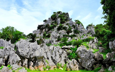
Daisekirinzan in Kunigami District, Okinawa Prefecture This video, "Oishi Forest Mountain|A walk in the sky" (大石林山 空中散歩), was created by "Okinawaworld." Daisekirinzan is a mountain in Okinawa's Kunigami District, about a 3-minute drive from Cape Hedo (辺戸岬, hedo-misaki), the northernmost point of the main island of Okinawa. As seen from 0:15 in the video, the island has a karst landscape created by limestone from 250 million years ago. The many strange rock formations and beautiful scenery is reminiscent of Guilin in China, known for its depictions in ink paintings. Nearby is Ashimui (安須杜), which has been a sacred place since ancient times. From Cape Hedo, the mountains seem steep and forbidding, but once you actually enter the mountains, you'll find a peaceful paradise of subtropical flora and fauna. Most of Daisekirinzan is designated as a specially protected area of Yanbaru National Park. You can enjoy the magnificent nature of Yanbaru while making your way through the two main trekking courses. The History of Daisekirinzan Photo:Daisekirinzan, Okinawa Daisekirinzan is a "quasi-national park" in Okinawa, in accordance with the Natural Parks Act. The park is managed with the aim of protecting the beauty of nature and contributing to the health, recuperation, and knowledge of Japanese citizens. On September 15, 2016, along with the official designation of Yanbaru National Park, a part of the area previously designated as Okinawa Kaigan Quasi-National Park was transferred to Yanbaru National Park. Daisekirinzan is a must-visit sightseeing area in Okinawa, even winning the "Tripadvisor Excellence Award 2018" on TripAdvisor for the fifth consecutive year. The Two Main Trekking Courses of Daisekirinzan Photo:Banyan Tree in Oishi Forest Mountain, Okinawa ① Strange Rock / Churaumi Panorama Course As seen from 0:36 in the video, this is a course where you can experience the tropical karst landscape at the northernmost tip of Okinawa. It takes about 60 minutes to complete the 1,200m course. You can see the strange rocks and massive boulders from 0:45 in the video. In addition to strange rocks and boulders, there are also many places of worship, such as the "Stone Forest Wall," which is said to be full of spiritual power. There is also an observation deck where you can enjoy a panoramic view, and during good weather conditions, you can even see Yoron Island (与論島, yoron-to) and Okinoerabu Island (沖永良部島, okinoerabu-jima) in Kagoshima Prefecture (鹿児島県, kagoshima-ken). There is also a barrier-free course, which is 600 meters long and takes about 20 minutes to complete It's designed for the elderly and people in wheelchairs to enjoy. As seen from 2:00 in the video, there's also Eboshi-iwa Rock (鳥帽子岩) towering into the sky, as well as the mysterious Nabe-ike Pond (鍋池). ② Yanbaru Forest Course The Yanbaru Forest Course can be seen from 2:09 in the video. Even in the midst of Daisekirinzan, this is an area where the subtropical trees grow especially densely. It takes about 30 minutes to traverse the 1,000m-long course, and you can enjoy the magnificent natural scenery, including the huge banyan tree seen from 2:32 in the video. Summary of Daisekirinzan Photo:The Phantom Flower Mucuna Macrocarpa, Okinawa In addition to the two famous trekking courses, there are many other sightseeing spots in Daisekirinzan. The Okinawa Stone Culture Museum (沖縄石の文化博物館, okinawa-ishi no bunka hakubutsukan) is a geological and ethnic museum centered around Okinawan stones. Gajumaru Road (ガジュマルロード), also known as the "Path of the Wind" (風の道, kaze no michi) is a road winding along gorgeous scenery. If you're lucky, you might even get the chance to see the rare "Mucuna Macrocarpa," which grows naturally in the mountains of Yanbaru. Even Okinawans rarely come across this "phantom flower." In recent years, Daisekirinzan has been attracting attention as the largest spiritual area in Okinawa. Consider adding Daisekirinzan to your itinerary when you visit Okinawa! 【Official Homepage】Yanbaru National Park Daisekirinzan https://www.sekirinzan.com/en/ 【Tripadvisor】Daisekirinzan https://www.tripadvisor.com/Attraction_Review-g1025649-d1373544-Reviews-Daisekirinzan-Kunigami_son_Kunigami_gun_Okinawa_Prefecture.html -
 Video article 3:55
Dogashima, Shizuoka Prefecture, Is a Scenic Tourist Spot Formed by Ancient Eruptions. The Powerful Scenery of Its Steep Cliffs Makes It a Must-Visit Spot in Izu!
Nature- 207 plays
- YouTube
Introducing Dogashima in Shizuoka Prefecture! This video, "Dogashima - Shizuoka - 堂ヶ島 - 4K Ultra HD" was produced by “TokyoStreetView- Japan The Beautiful.” It introduces beautiful views of Dogashima in Shizuoka prefecture in 4K resolution. Dogashima, located in Nishizu-cho, Kamo-gun, Shizuoka Prefecture in Japan's Tokai region, is an area famous for the fishing industry. It is also called the "Matsushima of Izu" for its beautiful scenery. (Matsushima is one of the "Three Views of Japan"). You can enjoy marine sports such as diving, as well as tour famous spots by boat in Dogashima. Dogashima faces Suruga Bay and has beautiful scenic views. Trips like this, where you can explore famous local areas, are growing in popularity. What Kind of Place Is Dogashima? Photo:Dogashima Dogashima was formed by underwater debris flow from ancient eruptions, and from the pumice/volcanic ash layer that fell and piled up on top of that. It is thought that the waves carving away at this geological layer created the steep cliffs and strangely shaped rocks that you can see in the video. The towering cliffs can be seen from the beginning of the video. There is a famous spot called Dogashima Tensodo Cave in Dogashima, which was formed by the waves eroding the ceiling of a sea cave, and the ceiling collapsing as a result. You can also enjoy this beautiful sight by going on a cruise, such as the Blue Cave Tour Boat and the Dogashima Cave Excursion Boat, Senganmon Cruise boat. The Islands of Dogashima Photo:Dogashima Tombolo The islands of the Dogashima area are: Zoshima (Denbe Island), Nakanoshima, Okinose Island, and Takashima Island. They are also called Sanshirojima. The name Sanshiro comes from the name of a vassal of Minamoto no Yoritomo, who was called “Izu’s Sanshiro.” At low tide, sandbars appear at Zoshima. This phenomenon is called "Dogashima’s Tombolo," and you can walk across this land formation. On a sunny day, you can also enjoy the beautiful sunset gleaming across the islands. Recommended Spots in the Nishiizu Area Photo:Image of Nishiizu Dogashima promenade In the Dogashima area, try to stop by the Dogashima Promenade, the Instagrammable sights of Namakokabe Street, and the Kayama Yuzo Museum. There’s also Sawada Kouen Rotenburo, Dogashima Garden, Izu Nature School, and the suspension bridge at Ran no Sato, all of which are popular tourist destinations. If you’re looking to grab something to eat, we recommend Seafood Dining Iwaya and Dogashima Shokudo. Onsen hotels, such as New Ginsui, Dogashima Accueil Sanshiro, and Umibe no Kakureyu Seiryu are all great choices where you can enjoy hot springs as well. In the footage, you can see the port town around the Dogashima area at 2:29 in the video. Enjoy the townscape of Dogashima! Summary of Dogashima Photo:Dogashima Cruise Dogashima is popular area in Shizuoka prefecture where you can enjoy the amazing scenery of the ocean. Try going on a cruise in Dogashima and enjoy a beautiful view of the islands. If you are planning to go to the Dogashima area in Izu, check out the information on the Izu Peninsula Geopark information site. ◆Dogashima Area Overview◆ 【Address】Dogashima, Nishna, Nishiizu-cho, Kamo-gun, Shizuoka Prefecture 【Acccess】70 minutes by bus from Shuzenji Station of the Izuhakone Railway, 60 minutes by bus from Izukyu-Shimoda Station 【Parking】 Available(Free Parking) 【Official Website】Nishiizu Tourist Guide | Dogashima – Nishiizu Town Tourism Association https://en.nishiizu-kankou.com/ 【Tripadvisor】Dogashima https://www.tripadvisor.com/Attraction_Review-g1121209-d2167482-Reviews-Dogashima_Island-Nishiizu_cho_Kamo_gun_Shizuoka_Prefecture_Tokai_Chubu.html -
Video article 3:47
The Caldera of Mt. Aso: A Magnificent Landscape Created by Nature. The Natural Wonderland, Full of Mysterious Scenery, Is Said to Have Been Created by the Gods!
Nature- 306 plays
- YouTube
The Caldera of Mt. Aso This PR video, titled "The Heritage of Tomorrow- God, Nature, and Man," is produced by “N.a” to promote Mt. Aso in Kumamoto Prefecture. The beautiful landscape of Kyushu, including Mt. Aso, can be seen throughout this video. Mt. Aso has a caldera produced by an ancient volcanic eruption, and the people have lived their lives here believing in the power of the gods and nature. A Caldera is a large circular depression in a volcano created from the body of the volcano collapsing. You can see a view of the caldera, billowing with volcanic smoke, in the video at 1:54. The Beautiful Scenery of Mt. Aso Photo:Aso Panorama Line Aso Shrine, known as the Ichinomiya of Higo province (肥後国 : Higono Kuni), and located at the foot of Mt. Aso, is a historic location, considered to be the number one shrine in Higo province. Its origins trace back to mountain and volcano worship in the Jomon period. Legend has it that the god of the shrine, Takeiwatatsumi no Mikoto, once kicked out water from the mountain in order to build a rice field around Mt. Aso. The area around Aso Caldera is designated as a Aso UNESCO Global Geopark. It's a beautiful location where you can learn about the natural landscape. At Aso UNESCO Global Geopark, focused on active caldera, you can see large clouds of smoke climbing high up into the sky. You can also enjoy a view of Aso Geopark in this video. Tourist Spots in the Mt. Aso Area! ©阿蘇市 Modifying Daikanbo (大観峰: Daikanbo) is the highest peak at Aso Kitagairin Zan (阿蘇北外輪山:Aso Kitagairin Zan) in Aso city阿蘇市 : Aso-shi). From the Daikanbo observantory, you can enjoy a spectacular view of the "Five Mountains of Aso" (阿蘇五岳: Aso Gogaku). The Aso Milk Road leading to Daikanbo is great for sightseeing. There's a parking lot and it can be easily accessed, so we definitely recommend checking it out if you have the chance. Some other hidden gems where you can explore the natural scenery of Mt. Aso include Shirakawa Suigen and Kusasenrigahama. Relax in the Hot Springs and Feel the Blessings of Nature! Photo:Kurokawa Hot Springs There are a lot of hot spring facilities around Mt. Aso due to the many volcanoes in the area. One that we recommend visiting is Kurokawa Hot Springs. We especially recommend Aso Farm Land, created with the idea of promoting health. You can enjoy delicious local cuisine and natural hot springs to heal your body after exploring Mt. Aso. Summary of Mt. Aso There are many sightseeing spots where you can experience the beautiful landscape of Mt. Aso. In the video, you can enjoy beautiful views of Mt. Aso with calm music playing in the background. Enjoy the mysterious scenery of Mt. Aso, famous as a land created by the gods. There are many volcanoes in Japan besides Mt. Aso. People have lived in reverence for them since ancient times. We hope to see you at Mt. Aso to enjoy the relaxing hot springs, beautiful scenery, and the spiritual shrines! 【Tripadvisor】Asosan (Takadake) https://www.tripadvisor.com/Attraction_Review-g298212-d320703-Reviews-Mt_Aso-Kumamoto_Prefecture_Kyushu.html -
Video article 4:40
The Kawachi Wisteria Garden - One of the Most Popular Tourist Attractions in the World, This Garden Is Decorated With an Overwhelming Amount of Wisteria! Passing Through the Long Wisteria Tunnel Is Sure To Leave You Feeling Refreshed!
Nature- 89 plays
- YouTube
This video is called "Kawachi Wisteria Garden [8KHDR]" by "Japan Explorers." This video introduces the Kawachi Wisteria Garden, which was selected as one of the 31 most beautiful places in Japan by the American CNN. The Kawauchi Wisteria Garden, a tourist attraction that Fukuoka Prefecture is proud of, is decorated with wisteria, and its beauty is recognized by the world. The wisteria trellises and the 110-meter-long wisteria tunnel, as well as the colored leaves in November and December, make this a place with countless breathtaking views. In this video, you can see a lot of beautiful wisteria at the Kawachi Wisteria Garden. Be sure to check it out! -
Video article 4:05
This Place Screams Instagram! The Cobalt Blue Waters of Fukushima's "Goshikinuma" Are Out of This World!
Nature Travel- 165 plays
- YouTube
Sightseeing at "Goshikinuma" This video, titled "Goshikinuma - A Fantastic Colored Pond in Fukushima Japan" (Fantastic Colors Pond in Fukushima Japan 五色沼湖沼群 神秘的な絶景の福島裏磐梯・東北の美しい風景), introduces the beautiful cobalt blue lakes of "Goshikinuma," located on the north side of Mt. Bandai (津磐梯山, Aizu Bandaisan), in Fukushima Prefecture, located in Japan's Tohoku region. "Urabandai" in Fukushima Prefecture has about 30 small and large lakes and swamps, which are characterized by various shades of green, red, and blue. It is also called the "Mysterious Lake" because of its beauty, and has received one Michelin Green Guide star. Please enjoy the scenic beauty of nature during the season when the fresh greenery is at its best. What Is Goshikinuma Like? Photo:Benten-numa at Goshikinuma Goshikinuma consists of Bishamon-numa (毘沙門沼, Bishamon-numa), Aka-numa (赤沼, Aka-numa), Midoro-numa (みどろ沼, Midoro-numa), Benten-numa (弁天沼, Benten-numa), Ruri-numa (るり沼, Ruri-numa), Ao-numa (青沼, Ao-numa), and Yanagi-numa (柳沼, Yanagi-numa), which are introduced from the beginning of the video. In addition to the cobalt blue lakes, the fresh greenery is reflected on the water's surface as shown in the video at 1:56, and the emerald green Ruri-numa is also beautiful. There are also swamps that show different colors depending on the season and weather, such as emerald blue, turquoise blue, and pastel blue. You can rent a rowing boat in Bishamon-numa, so we recommend that you take your time and enjoy the beauty of nature. Sightseeing at Goshikinuma Photo:Bishamon-numa Bandai Asahi National Park (磐梯朝日国立公園内, Bandai Asahi Kokuritsu Koen) in Fukushima Prefecture is a special protected area. The area around the scenic Goshikinuma in April is a hiking course where you can enjoy cycling. Be sure to choose a sunny day to go on a sightseeing trip. It's a good idea to walk along the Goshikinuma Nature Exploration Road when the autumn leaves are at their most colorful. There are gourmet spots where you can enjoy lunch, accommodations such as the Goshikinuma Hotel, campsites, and holiday villages as well. Make sure to book accommodations and tours, to travel around at and enjoy the surrounding sights. Sightseeing Spots Around Goshikinuma Photo:Hibara Lake When you come to Goshikinuma for sightseeing, you should definitely check out the nearby sightseeing spots. Recommendations include Mount Bandai's largest lake "Hibara Lake," which is located in the center of the plateau, "Urabandai Roadside Station" for local gourmet and sweets, the drive course "Bandai Azuma Lake line," and "West Azuma Sky Valley" overlooking the superb view. Goshikinuma Sightseeing Video Summary Goshikinuma in Fukushima Prefecture is a hidden sightseeing spot with a beautiful cobalt-blue lake surface. We hope the beauty was conveyed through the video. The sparkling lake is so attractive that you won't get tired of looking at it even if you spent the rest of your life doing so. If you are going on a sightseeing trip to Goshikinuma in Fukushima Prefecture, please enjoy the miraculous scenery, created by nature, to your heart's content. ◆Goshikinuma Lakes and Marshes Overview◆ 【Address】〒966-0401 Kita-Shiobara-mura, Yama-gun, Fukushima 【Access】25 minutes by bus from Inawashiro Station on the Banetsu West Line 【Parking】 Available 【Telephone No】0241-32-2850 【Tripadvisor】Goshikinuma https://www.tripadvisor.com/Attraction_Review-g1120994-d1222009-Reviews-Goshikinuma_Lake-Kitashiobara_mura_Yama_gun_Fukushima_Prefecture_Tohoku.html -
Video article 2:47
Arashiyama Is One of the Most Beautiful Spots in Kyoto, and a Place to Experience the Natural Beauty of Japan. Take a Trip to the "Arashiyama Bamboo Forest," a 400-Meter-Long Natural Bamboo Forest, to Soothe Your Body and Mind!
Nature Travel- 351 plays
- YouTube
The Arashiyama Bamboo Forest in Arashiyama, Kyoto! This video is titled "Arashiyama Bamboo Forest|the Voices of the Wind and Fresh Greenery Dancing Towards the Heavens|Kyoto・Arashiyama. (Arashiyama Bamboo Forest Kyoto Japan) Sagano|Healing Landscape, Healing, a Sketch of Sounds #16 / Ryuju." It introduces the Arashiyama Bamboo Forest in Sagano (嵯峨野, Sagano), Arashiyama, in Kyoto City (京都市, Kyoto-Shi), Kyoto (京都府,Kyoto-Fu), in the Kansai region (関西地方, Kansai-Chiho) of Japan. The Arashiyama Bamboo Forest is a path from Okochi Sanso Villa in Sagano (嵯峨野, Sagano), in the Ukyo-Ward (右京区, Ukyo-Ku) of Kyoto, to Nonomiya Shrine. As you can see from 0:18 in the video, the Arashiyama Bamboo Forest is roughly 400 meters long, and this refined site is one of the most famous tourist destinations in Arashiyama, Kyoto. You can see the fresh greenery of the bamboo forest, along with soothing music. It's also called "Bamboo Grove." Togetsukyo-Bridge and Katsura River (桂川, Katsura-Gawa) are also within walking distance of the forest. Events at the Arashiyama Bamboo Forest Photo:Kyoto・Arashiyama Hanatouro Every winter at the Arashiyama Bamboo Forest, a special night-time illumination event called "Kyoto Arashiyama Hanatouro" is held. Here, you can enjoy a beautiful night view of the Bamboo Forest lit up at night. For access to the Arashiyama Bamboo Forest, we recommend the route from Tenryuji Temple to the North Gate where Nomiya Shrine is located. Since there is no parking, we recommend going by train. The Sagano Romantic Train Photo:Sagano Romantic Train The Sagano Romantic Train is a sightseeing train in Arashiyama, which was reconstructed from a defunct railroad and was reborn as a new tourist attraction in the area. It runs along the Hozu River (保津川, Hozu-Gawa) from "Torokko Kameoka Station," which is close to Umahori Station on the JR West San'in Main Line, to "Torokko Saga Station via Torokko Arashiyama Station where the bamboo forest is located. The train operates from 9:00 A.M. Check the official Sagano Scenic Railway website for a detailed schedule. Dining in Arashiyama, Kyoto Photo:Arashiyama, Kyoto・Croquette There are many restaurants and places to grab lunch in Arashiyama. We'll introduce a few below. The most popular and classic food are the croquettes from Nakamuraya Shop. The croquettes from Shop Arashiyama Tanaka are also reasonably priced and we recommend them as well. Yuba-suki croquettes are also available at Yoshiya Arashiyama Honten. You won't be able to find them anywhere else. Saga Tofu Ine is a restaurant offering tofu dishes, yuba soup, and yuba donuts. As for dessert, Shinpachi Chaya sells authentic gelato, which won third place in the Gelato World Tour. Besides these, there are a number of delicious treats perfect for your Instagram, and as gifts. For example, the upside-down soft serve ice cream from Kyozuan! Sightseeing in the Arashiyama Area Photo:Rickshaw In addition to the Arashiyama Bamboo Forest, there are many more sightseeing spots in Arashiyama as well. The most famous is Arashiyama Onsen (Hot spring). There is also a footbath near Arashiyama Station, so you can soak your legs and feet in a shallow hot spring bath to rid yourself of the fatigue from your travels. Another activity you can enjoy in Arashiyama is dressing up as a maiko in kimono and going sightseeing! You can dress up as a maiko for 2 hours and experience what Arashiyama was like in the Heian Period (794-1185 AD). The rickshawsin Arashiyama can also take you around the surrounding area, to places such as Togetsukyo-Bridge and Okochi Sanso Villa. The god of marriage and childbirth is enshrined at Nomiya Shrine, and there is also a power spot called Okameishi (Turtle Rock). It is said that if you rub this turtle-shaped stone while praying, your wish will be granted within a year. We also recommend checking out other tourist sites, such as the Kimono Forest, Daikakuji Temple, the "Rinsen Style Garden" (a strolling garden incorporating ponds and hills), Jojakkoji Temple, and Hozugawa River Boat Ride. Summary of the Arashiyama Bamboo Grove Photo:Arashiyama, Kyoto・Bamboo Grove Did you enjoy reading about the Arashiyama Bamboo Grove and other surround points of interest? Aside from the beautiful scenery of the bamboo grove, there are many other sightseeing spots in Arashiyama. Be sure to bring a map when you come and visit the beautiful bamboo groves of Kyoto and experience the history of Japan! 【Tripadvisor】Arashiyama Bamboo Forest https://www.tripadvisor.jp/Attraction_Review-g298564-d1497822-Reviews-Bamboo_Forest_Street-Kyoto_Kyoto_Prefecture_Kinki.html -
Video article 5:08
Akiyoshidai and Akiyoshido Cave, Two of the Most Beautiful Spots In... Is This Actually Japan?! Be Amazed by the Mystery and Grandeur of Japan's Nature!
Nature- 110 plays
- YouTube
This video was shot by "STARstreamer YOSUKE" and is titled "[Best View in Yamaguchi Prefecture] Akiyoshidai Benten Pond in Akiyoshidai 4K." This video introduces Akiyoshidai, one of the largest karst plateaus in Japan, and Akiyoshido Cave, one of the largest natural limestone caves in Japan, located underneath the plateau. Both Akiyoshidai and Akiyoshido Cave have been designated as Special Natural Monuments since 1964. The mystique and grandeur of nature and the complete change between scenery above ground and below ground is truly impressive, making it a place to throw on your bucket list. This video shows actual footage of Akiyoshidai and Akiyoshido Cave, so be sure to check it out! -
Video article 2:15
Virgin Forests and Autumn Leaves at Shirakoma Pond, Nagano
Nature Travel- 89 plays
- YouTube
Autumn Leaves at Shirakoma Pond, Nagano, Japan: Video Introduction Photo:Autumn leaves at Shirakoma Pond, Nagano Prefecture This video, titled "[4K] Mysteriously Spectacular Views|Autumn Leaves at Shirakoma Pond - (shot on BMPCC6K)" ([4K] 神秘の絶景 天空の湖 白駒池の紅葉 - Autumn Leaves at Shirakoma Pond - (shot on BMPCC6K)), was uploaded by "AQUA Geo Graphic." Shirakoma Pond in Nagano Prefecture is known for its beautiful autumn foliage. The reflection of the colorful trees on the surface of the lake is so beautiful you'd only expect to see it in a painting. Shirakoma Pond is blessed with abundant nature, and is a popular location for hiking as well. The pond is a popular tourist spot that attracts many visitors throughout the year because of its wonderful scenery that changes with the seasons, especially during autumn. Enjoy the beautiful contrast of between the green, yellow, and fiery red autumn leaves reflected on the mirror-like surface of the lake in this 2-minute long 4K video. Where is Shirakoma Pond? Location of the Pond in Nagano Famous for Its Autumn Leaves Photo:Shirakoma Pond from Takami-ishi, Nagano Prefecture Shirakoma Pond is located in the eastern part of Nagano Prefecture, on the border between the towns of Koumi and Sakuho. Located on the Yachiho Highland (Yachiho Kogen) at an elevation of 2,115m (~6,900 ft), Shirakoma Pond is the highest and largest natural lake in Japan. The pond is also known for its extremely high transparency, allowing visitors to see as deep as 5.8 meters below the surface. Shirakoma Pond is easily accessible despite its location on the Yachiho Highland. With a well-maintained promenade, it's becoming a popular tourist attraction. When to See Autumn Leaves at Shirakoma Pond – Best Season and Photo Spots Photo:Autumn leaves at Shirakoma Pond, Nagano Prefecture The area surrounding Shirakoma Pond is known as one of Japan's three largest virgin forests, and during autumn, when the leaves change color, the virgin forest, filled with azaleas, birch trees, and maples, changes color to brilliant shades of red and yellow. Every year, the area is crowded with tourists who come to view the autumn foliage. If you're planning to visit Shirakoma Pond, autumn is definitely the best season to come so you can see the beauty of the autumn leaves. In the high elevation areas of Japan's Chubu region, the best time to view the autumn leaves is from late September at the earliest, and from early October on an average year. Since the forecast for autumn leaves at elevations above 2,000m is said to be largely unchanged, the best time to view the autumn foliage at Shirakoma Pond in 2023 is expected to be from late September to mid-October. During autumn, when the leaves are in season, Shirakoma Pond is crowded tourists. If you're looking to take photos, there are two great spots in front of the mountain lodges "Shirakoma-so" (白駒荘) and "Seitai-so" (青苔荘) that overlook the lakeside area. The two lodges, situated on opposite sides of Shirakoma Pond, are well known for their sunrises and sunsets which can be photographed together with the pond in the foreground. Hiking at Shirakoma Pond! Photo:The moss forest around Shirakoma Pond, Nagano Prefecture There are several hiking trails around Shirakoma Pond that can be enjoyed even by beginner hikers. We recommend the route from Shirakoma Pond (白駒池) to Takami-ishi (高見石), which has a minimal elevation change and can be easily hiked. The hike takes about 2 hours and departs from the Shirakoma Pond parking lot. The hike proceeds along a trail on which hikers can admire the beautiful mosses growing in the area. Once you reach a fork in the road, head toward Takami-ishi Lodge (高見石小屋). After hiking up behind Takami-ishi Lodge, you'll arrive at Takami-ishi. From Takami-ishi, you can enjoy a spectacular view of Japan's Northern and Central Alps and Shirakoma Pond. After admiring the view, descend from Takami-ishi toward Shirakoma Pond. Follow the boardwalk circling the mystical Shirakoma Pond before returning to the parking lot to end the hike. Although the trail around Shirakoma Pond is well maintained, it becomes slippery when it rains. When visiting Takami-ishi, a series of rock formations, in particular, extreme care should be taken to avoid injury or accidents. Please be prepared to wear comfortable walking shoes and clothes that are easy to move in, and check the weather before you go out. Additionally, because the area around Shirakoma Pond is mountainous, temperatures can vary greatly. Please bring warm clothes to adjust for the temperature changes. After enjoying hiking in the magnificent nature of Nagano, we recommend taking a breather at one of the hot spring resorts in the area. The Shirakoma Pond area is dotted with facilities where you can enjoy hot springs and take in the beautiful scenery. It's a great way to relax after a nice day of hiking. Camping at Shirakoma Pond Photo:The tent campsite at Takami-ishi Lodge, Nagano Prefecture In addition to hiking and viewing the autumn leaves at Shirakoma Pond, there are also a few locations where you can enjoy camping. Seitai-so Seitai-so, the mountain lodge mentioned earlier, has a tent site located right next to it where you can set up a tent right by the lake. The tent site is available year-round and you can even enjoy a beautiful starry sky with a view of the pond frozen over in the winter. Keep in mind that the tent site is reservation only and all garbage must be taken with you when you leave. Lodge Hours: 7:00 am - 7:00 pm. ※Hours may vary by season. Fee: The tent site is free of charge. General lodging starts at 5,500 yen/person for adults. Takami-ishi Another campsite is the Takami-ishi Tent Site, located beside Takami-ishi Lodge. Unlike the tent site at Seitai-so, Takami-ishi does not accept reservations, and is open to campers on a first-come, first-served basis. Additionally, the owners of the lodge provide commentary about the stars at night on the terrace, and invite guests to join them to listen. While not located directly next to Shirakoma Pond, it's only about 10 minutes from the pond by car. Lodge Hours: 10:00 am - 2:00 pm Fee: Tent site: 600 yen/person. General lodging starts at 5,500 yen/ person. Both of the above facilities also having standard accommodations as well, so if you want to stay the night and enjoy the starry skies and autumn leaves, but don't want to stay in a tent, you can always book a room in the lodges. Parking and Crowding at Shirakoma Pond During the Autumn Foliage Season Photo:Autumn leaves at Shirakoma Pond, Nagano Prefecture To get to Shirakoma Pond, it's best to use the parking lot on Route 299. It takes about 15 minutes to reach the pond on foot from the parking lot. That being said, because it's a famous spot for viewing the autumn leaves, more than 180,000 people visit Shirakoma Pond during the autumn foliage season, and the parking lot becomes incredibly crowded, especially on weekends. At the same time, many cars are entering and exiting the parking lot, resulting in heavy traffic congestion on the surrounding roads. The most crowded hours at Shirakoma Pond are between 10:00 am to 2:00 pm on weekdays, and 9:00 am to 2:00 pm on weekends and holidays. If you visit Shirakoma Pond to see the autumn leaves on a weekday, it may be better to go between 6:00 am and 9:00 am. On weekends and holidays, it might be smoother to go between 6:00 am and 8:00 am. However, in the past, there have been some reports that the parking lots were full as early as 9:00 am, so be sure to check the real-time parking conditions when visiting. For real-time information on congestion around Shirakoma Pond, you'll have the most luck using Twitter. Look up "白駒池" (Shirakoma Pond) in the Twitter search box to check the latest tweets. It's also recommended that you check live cameras installed at the Shirakoma Pond parking lot. Access the official website of the Shirakoma Pond toll parking lot to view the live camera, which is updated every 5 minutes. This is useful for checking the status of the parking lot and the weather in real time. Although it is convenient to drive to Shirakoma Pond during the fall foliage season, you may want to consider using public transportation if you're trying to avoid crowds and traffic jams. Summary of Autumn Leaves at Shirakoma Pond Photo:Autumn leaves at Shirakoma Pond, Nagano Prefecture Shirakoma Pond, located in Nagano Prefecture and famous for its autumn foliage, is the highest natural lake in Japan at 2,115 meters above sea level. During the fall foliage season, the azaleas and birch trees change color beautifully, creating a picturesque landscape. The Shirakoma Pond area is also famous for its "moss forest," which is home to 485 species of moss. The best time to see the mosses is from mid-June to the end of July, after Japan's rainy season, and visitors can enjoy the moss forest until early November every year. We invite you to experience the mysterious beauty of Shirakoma Pond as expressed in the video. 【TripAdvisor】Shirakoma Pond -
Video article 5:26
The Hoshitoge Rice Terraces of Niigata Prefecture! Discover the Beautiful Rice Fields of Japan With This Must-See View!
Nature Travel- 52 plays
- YouTube
Hoshitoge Rice Terraces: Video Introduction This video, titled "[4K] [Original Scenery of Japan] Rice Terraces at Hoshitoge, Tokamachi, Niigata Prefecture" ([4K]【日本の原風景】新潟県十日町星峠の棚田。雲海と光芒。), was uploaded by "KYODO NEWS." In the video, you can see footage of the Hoshitoge Rice Terraces, which were selected by foreign tourists as the #1 bucket list view in Japan. The reflections on the water-filled rice fields and the sea of clouds that looks different throughout the day are captured in this beautiful 4K video. You can't help but be moved by these views. The video is accompanied by closed captions with tourist information, so be sure to turn them on while watching the video! Rice Fields in Japan Cultivation of rice fields in Japan is believed to have started during the Yayoi Period (300 BC - 250 AD). Rice has played an important role in the history of Japan, and has even been used historically as currency by farmers to pay taxes. Today, rice is a staple food in Japan, and while the exact number of rice fields in Japan is not known, according to the Ministry of Agriculture, Forestry and Fisheries, rice paddies account for 5.85 million acres of land. With Japan having a total landmass of 93.4 million acres, this means that more than 6% of Japan is rice paddies. Despite rice fields being made to grow rice, there are many places in Japan where you can see rice field art, such as Saitama and Aomori prefectures. The use of different colors of rice allows farmers to create incredible images inside the fields. Some other famous rice fields in Japan where you can see breathtaking views include the Shiroyone Senmaida Rice Terraces of Ishikawa Prefecture, the Maruyama Senmaida Rice Terraces of Mie Prefecture, and many more. Terraced rice fields prevent erosion, runoff, flooding, and other undesirable conditions, which is why they are often used in rice farming. Furthermore, they help nurture the land by allowing the water in the fields to slowly seep back into the ground, replenishing the groundwater. What Are the Hoshitoge Rice Terraces? Discover the Beautiful Scenery of Tokamachi, Niigata Photo:The Hoshitoge Rice Terraces of Tokamachi, Niigata Located in Tokamachi, Niigata, in Japan's Koshin'etsu region, the Hoshitoge Rice Terraces, numbering some 200 paddies, are spread across the hillside. Among the terraced rice fields scattered throughout the region, the Hoshitoge Rice Terraces are considered exceptionally beautiful. Depending on the weather and time of year, a sea of clouds and mirror-like water can also be seen at the rice terraces, making this a popular tourist spot with a variety of views. The Hoshitoge Rice Terraces have attracted attention both in Japan and overseas, as they were featured in the opening scene of NHK's historical drama "Tenchijin" (Heart of a Samurai) in 2009, and was recognized as a Japanese heritage that transcends borders by the Ministry of Agriculture, Forestry and Fisheries in 2022. The Hoshitoge Rice Terraces, a place where you can view the beautiful landscapes of Japan, are historic terraced rice fields created by the residents of Hoshitoge village more than 300 years ago. The area, including the village, has been selected as one of the "Top 100 Villages in Japan," and is one of Japan's leading scenic attractions. The Best Season to Visit the Hoshitoge Rice Terraces Photo:A sea of clouds over the Hoshitoge Rice Terraces, Tokamachi, Niigata One of the highlights of Hoshitoge Rice Terraces is the breathtakingly beautiful sea of clouds and mirror-like pools of water covering the fields. Unfortunately, the sea of clouds and mirror-like pools can only be seen during certain times of the year and under certain conditions. In addition, in order to capture the beautiful scenery in photographs, it's important to know in advance the best places to take photographs, so be sure to check before you visit. The best seasons for seeing a sea of clouds is during spring (late June) and autumn (mid-September). During these seasons, a sea of clouds is more likely to occur, and photographers from all over Japan flock to the area to enjoy the spectacular view. On the other hand, the best season for viewing the mirror-like pools is spring (around May to June) and autumn (around October to November). If you want to see both a sea of clouds and the mirror-like pools, be sure to visit in June. However, whether or not you can see a sea of clouds and a water mirror depends entirely on luck. The view in front of you will change depending on the conditions of the day. You will need some luck to take a good picture. However, if the conditions are right, you will be able to see a glowing sea of clouds or a scene enveloped in fog, and you will be able to capture a miraculous shot. Spring, Summer, Fall & Winter: Seasonal Views at the Hoshitoge Rice Terraces Photo:The Hoshitoge Rice Terraces covered in snow, Tokamachi, Niigata The Hoshitoge Rice Terraces are a beautiful sight in each of Japan's four seasons. In addition to the popular sea of clouds and mirror-like pools, you can enjoy colorful cherry blossoms in spring. In the summer, the rice terraces turn a deep green color and contrast with the bright blue sky. In autumn, the ears of rice shimmer with a golden glow, and in winter snow takes the place of water, creating a unique scene of pools of white snow. That being said, cars and motorcycles are unable to access the rice terraces when the snow gets too deep, and you may not be able to visit the rice fields during the winter. The Hoshitoge Rice Terraces also offer a different view during the daytime and at night. In particular, at sunrise and sunset, you can enjoy a beauty that is beyond words, no matter what season you visit in. Summary of the Hoshitoge Rice Terraces The Hoshitoge Rice Terraces are one of the most famous scenic views in Japan. It's a bucket list location, so if you're interested in visiting, we highly recommend adding it to your Niigata travel itinerary! To get to the Hoshitoge Rice Terraces in Tokamachi, Niigata, take the train to Matsudai Station and from there, it's about 20 minutes by taxi. For details on parking and directions, please check here. The rice terraces in Tokamachi, Niigata, including the Hoshitoge Rice Terraces, are not designed for the purpose of sightseeing. They are agricultural land that local people have inherited from their ancestors and carefully preserved. They are also private plots of land where farmers still cultivate rice. In addition to not entering the terraces, it's strictly prohibited to interfere with farm vehicles, take unauthorized photographs of farm work, or leave trash in the terraces. Please enjoy the spectacular scenery while observing proper manners and abiding by the rules. 【TripAdvisor】Hoshitoge Rice Terraces -
Video article 2:07
The Mysterious Beauty of the Kakita River in Shizuoka, Japan! Video of the Kakita River Flowing With Melted Snow Water From Mt. Fuji!
Nature Travel- 132 plays
- YouTube
The Kakita River, a Unique Stream Flowing Through Shizuoka, Japan: Video Introduction This video, titled "Explore the Enchanting Crystal Waters of Kakita River with 8KVR!!!" (『静岡県清水町』が制作の『神秘の清流 柿田川 〜8KVRで体験!空中散歩と絶景癒しスポット〜) was uploaded by "Shimizu, Shizuoka" (静岡県清水町). The Kakita River is Japan's shortest Class 1 river, one of the three clearest rivers in Japan along with the Nagara River and the Shimanto River, and is fed by spring water from Mt. Fuji. In 1985, the Kakita River was selected as one of the "100 Famous Bodies of Waters" by the Kakita River Spring Group because of the purity of its water. Be sure to take a look at the beautiful 8K VR video of the clear stream created by the spring water from Mt. Fuji. The Kakita River, a Clear Stream Filled With Spring Water From Mt. Fuji! Photo:Spring water at Kakita River Park The Kakita River is a Class 1 river in the Kano River system located in Shimizu, Shizuoka, in Japan's Tokai Region. It boasts the largest volume of spring water in Japan, and most of the water in the Kakita River is spring water from melting snow and rainwater from Mt. Fuji that seeps into the Mishima lava flow. It is one of the most unique rivers in Japan. It is one of the three clearest rivers in Japan and is also designated as a Natural Monument by the government of Japan in the category of geological minerals. The Kakita River stays at a cool 15°C throughout the year, with a constant volume, allowing the Mishima Baikamo, an underwater plant unique to rivers, to grow in abundance, nurturing a rich natural environment that provides comfort to the local people. At one time, factories moved into the area to exploit the abundant spring water, and the deteriorating quality of the water made it uninhabitable for fish. However, thanks to the efforts of the local people to improve the water quality and protect the habitat for kingfishers and various fish, the Kakita River continues to flow as a clear and transparent stream. What Gives the Kakita River Its Blue Color? Photo:Spring water at Kakita River Park Kakita River Park is located upstream of the Kakita River. Originally the ruins of Izumigashira Castle built by Hojo Ujiyasu, a daimyo known as "The Lion of Sagami," this historic place is home to one of the most photogenic spots on the Kakita River. The "Wakima," is one of the sources of the Kakita River and can be seen from the observation deck of Kakita River Park. This place was originally used as a well by a nearby factory. The blue-colored source seen from the second observation deck is a mysterious beauty and has become quite popular on Japanese social media. The Kakita River spring water appears blue because of the water's ability to absorb red light. The deeper the water gets, the bluer it becomes. The color of the spring water changes slightly depending on the season, weather, and time of day, but the deepest and most beautiful blue can be seen in the mornings during the summer. Highlights of Kakita River Park Photo:Kifune Shrine at Kakita River Park, Shizuoka In addition to the Wakima, you can also enjoy a picnic at Kakita River Park! You can rent a picnic set at the Shimizu Town Tourist Information Center "Wakura Kakita River" and have a picnic without having to bring your own equipment. You can also rent equipment for activities such as badminton, dodgeball, and Othello/Reversi. Kakita River Park is located in the town of Shimizu in Sunto Ward, not Shimizu Ward, so be sure not to mix them up if you plan on visiting! Kifune Shrine, famous for boosting one's luck in love, is located in Kakita River Park. This shrine is a branch of Kibune Shrine in Kyoto and is dedicated to the god of water, but it has become known as a shrine for praying for love. On the approach to the shrine, there is a stone monument, and touching the stone shaped like a rice ball is said to bring good luck. There is also a mizu-mikuji (water fortune) that when placed in water makes the characters appear, making it a popular power spot for couples and those seeking love. Restaurants Near the Kakita River Photo:Tofu cuisine at Kitchen Kawasemi There are a variety of restaurants and cafes near the Kakita River. At the roadside stop Yusui no Michi (湧水の道), adjacent to Kakita River Park, you can find Kitchen Kawasemi (キッチンかわせみ) and Shokuji-dokoro Kawasemi Honkan (食事処かわせみ本館) where you can enjoy tofu dishes using fresh spring water from the Kakita River. At Kitchen Kawasemi, you can enjoy cold tofu and yuba (tofu skin) the freshest wasabi. Coffee brewed with spring water from the Kakita River is also available. Shokuji-dokoro Kawasemi Honkan offers a kominka (traditional Japanese home) experience, with reservations given priority. Here, the serve bento boxed lunches with a choice of either hot tofu or cold tofu made the famous spring water from the area. Also nearby is a store where you can purchase tofu ice cream, firm or soft tofu made spring water, green rice crackers, and coffee beans called Kakitagawa Yusui Blend (柿田川湧水ブレンド). Stop by after a stroll in Kakita River Park! A Brief Overview of Shimizu, Shizuoka Shizuoka Prefecture is the 10th largest prefecture in Japan based on population (3.5 million), and is located 1 hour from Tokyo and Nagoya via shinkansen (bullet train). Shimizu is a small town located in northeastern Shizuoka with a population of just 32,000. It's close to both the sea and mountains and even hot springs. Summary of the Mysteriously Clear Kakita River The Kakita River is one of the smallest rivers in Japan, at approximately 1.2 km long. However, it's so transparent that it is one of the three clearest rivers in Japan. The blue spring water gushing up from the earth, which can be seen from the second observatory in Kakita River Park, is a popular, photogenic spot. Kakita River Park is also a sightseeing spot where families can enjoy picnics and outdoor activities during the spring and fall. Nearby is Sun to Moon Kakitagawa, a large commercial facility that includes a movie theater and a shopping mall. When sightseeing in Shizuoka Prefecture, be sure to stop by Shimizu! 【TripAdvisor】Kakita River Park -
Video article 8:51
Oze National Park Travel Guide: Discover Hiking Trails and the Nature of Oze, Fukushima + Learn How to Get to Oze National Park From Tokyo!
Nature Travel- 121 plays
- YouTube
The Skunk Cabbage of Oze National Park in 2022: Video Introduction This video, titled "The Skunk Cabbage of Oze Marsh, 2022|A Skunk Cabbage Colony in the Shimono Ohori River" (2022 尾瀬の水芭蕉 尾瀬ヶ原 下の大堀川ミズバショウ群生地), was uploaded by "Northen Japanese Alps Nature Video." The bright landscape of Oze National Park, introduced in the nine minutes of video, is as beautiful as an impressionist painting. In the video, taken on May 29th, 2022, you can see there is some snow left on the surface of Mt. Shibutsu (至仏山, Shibutsuzan) and the majestic mountain can be seen towering against the blue sky. Fully bloomed skunk cabbages sway in the wind on the vast marshland at the foot of Mt. Shibutsu. The abundance of water in Oze National Park is also home to frogs and other creatures and you can even hear frogs, a sound you won't hear in the cities. Walking along the boardwalk of Oze Marsh (尾瀬ケ原, Ozegahara) while listening to the bubbling of the Shimono Ohori River (下ノ大堀川 Shimono Ohori River) is therapeutic. Oze, a Place Whose Beauty is Sung About in Traditional Japanese Songs Photo:Oze National Park The beauty of Oze is no secret to the people of Japan, and it has even been featured in traditional Japanese songs dating back to the 1940s. But for those of us not familiar with Oze, here's a quick introduction. Oze is a plateau that straddles the four prefectures of Fukushima, Niigata, Gunma, and Tochigi. Oze is a basin surrounded by 2000-meter-tall mountains, such as Mt.Shibutsu (至仏山, Shibtsusan), Hiuchigatake (燧ヶ岳, Hiuchigatake), Mt. Keizuru (景鶴山, Keizuruyama), and Mt. Nakahara (中原山, Nakaharayama). The marshland centering on Oze Marsh, which is said to have been formed around 10,000 years ago, was designated as Oze National Park (尾瀬国立公園 Oze Kokuritsu Koen) in 2007 and as such, the terms "Oze" and "Oze National Park" are synonymous with one another. Oze National Park is a major scenic spot that has been selected as one of the Top 100 Views of Japan. Other than the marshland of Oze Marsh, many ponds and swamps can be seen on the nearby mountainsides. After the snow melts in May, all the plants and trees bloom at once. There are boardwalks and benches as well, so visitors can enjoy a refreshing walk while taking in all of the natural scenery. The Skunk Cabbage of Oze National Park – A Treat for the Eyes Photo:Skunk cabbage Asian Skunk Cabbage is characterized by its large white petals, but these white petal-like things are not actually petals, rather, they are bracts, which are specialized leaves. Skunk Cabbage is called "Mizubasho" in Japanese (水芭蕉, lit. 'Water Banana'). The name comes from the shape of its leaves, which resemble those of the Japanese banana plant, and from the fact that it grows near water. It's a perennial plant of the arum family that grows in mountainous marshlands, and its flowers are at their best from late May to mid-June in Japan. Although bloom dates are dependent on the amount of snowfall each year, the best time to see skunk cabbage in Oze National Park is the same; late May to early June. In the first week of June especially, Oze National Park is crowded with tourists looking to see the clusters of skunk cabbage in bloom. The Nature of Oze National Park & 2 Popular Hiking Courses in the Area There are many hiking courses in Oze National Park, but the two most popular hiking courses are the Ozegahara Course and the Ozenuma Course. These two courses are recommended for first-time visitors to Oze National Park. Incidentally, the hiking course introduced in the video is the Ozegahara Course. Photo:Ozegahara ●Ozegahara Course This course circles Oze Marsh, the largest marshland on Japan's mainland. The boardwalk is well maintained, so even beginners can walk the course with ease. [Main route] Hatomachi Toge (鳩待峠, Hatomachitoge)→ Yamanohana Visitor Center (山ノ花, Yamanohana)→ Kamino - Ohori River (上ノ大堀川, Kamino Ohori Kawa)→ Ushikubi (牛首, Ushikubi)→ Miharashi (見晴, Miharashi)→ Ryugu Hut (龍宮小屋, Ryugu Goya) (Overnight stay). ※If you're visiting on a day trip, turn back at Kamino - Ohori River or Ushikubi. Ryugu Hut→ Miharashi→ Akatashiro Branch (Akadashiro Bunki)→ Yoppi Suspension Bridge (ヨッピ吊橋 Yoppi Tsuribashi)→ Ushikubi→ Yamanohana Visitor Center→ Hatomachi Toge [Video] 1:28 - Walkers on a Well-Maintained Wooden Path Photo:Oze Marsh and Hiuchigatake ●Ozenuma Course This is a hiking course around Lake Ozenuma and it's the course with the least amount of inclines and declines. Although this course can be hiked on a day trip, it's recommended that you stay overnight at a lodge. Lake Ozenuma at sunset with the stars in the night sky makes for an unforgettable experience. The Numayama Pass Observation Deck (沼山峠展望台, Numayama Toge Tenboudai) is located at the end of a conifer forest uphill from the Oze Numayama Pass bus stop. Here you can enjoy a panoramic view of Lake Ozenuma. On the first day, go to Sanpeishita (三平下) via the east bank of Lake Ozenuma. From Sanpeishita, you can see Hiuchigatake (燧ヶ岳, Hiuchigatake) and Lake Ozenuma, making it a popular vantage point. On the second day, start from the south bank of Lake Ozenuma to Numajiri (沼尻, Numajiri). Numajiri is also a beautiful place with ponds and in spring and summer, you can see pygmy water-lilies and Japanese thistle. After passing through the north bank of Oze Marsh, return to Numayama Pass. [Main route] Numayama Pass→ Ozenuma Villa (Overnight stay) Ozenuma Villa→ Numajiri→ Oze Marsh→ Numayama Pass Hotels, Hot Springs, and Where to Eat Near Oze National Park Photo:The Hatomachi Toge Rest Area The Hatomachi Toge Rest Area is located at Hatomachi Toge, the starting point of Ozegahara in Gunma Prefecture. Many tourists use this spot to prepare before hiking and to eat. The Hanamame Soft Cream ice cream is also popular. For visitors to Oze National Park, we recommend the Sky Terrace (天空テラス, Tenku Terasu) located 2,000 meters above sea level and the free Foot Bath in the Sky (天空の足湯, Tenku no Ashiyu). It takes about 15 minutes by the Nikko Shiranesan Ropeway (日光白根山 Nikko-Shirane San) to reach the summit station. Located on the border with Nikko, Tochigi, you can relax while enjoying a view of Mt. Nikko-Shirane. At Oze Katashina, a roadside station in Tone, Gunma Prefecture, visitors can enjoy direct sales of fresh highland vegetables from Katashina Village (片品村, Katashina Mura), as well as delicious meals prepared using locally grown vegetables at Katashina Diner (かたしな食堂, Katashina Shokudo)" and "Village People's Kitchen (村民キッチン, Sonmin Kicchin)." If you are considering staying near Oze National Park, Oze Hut (尾瀬小屋 Oze Koya) is another great spot we recommend. Despite the name of "hut," it's clean and has excellent facilities, such as the Oze Hut Terrace (尾瀬小屋テラス Oze Koya Terasu), which is open to outside visitors, as well as hot springs. The food is so good that it's hard to believe that it's located in the middle of Oze Marsh. How to Get To Oze National Park From Tokyo From Tokyo there are several ways to get to Oze National Park and there are also several different trailheads to enter the park from. From Tokyo, the easiest entry to the park via public transportation is the Hatomachi Toge trailhead. Tokyo Station to Oze National Park: Hatomachi Toge Trailhead From Tokyo Station, take the Joetsu Shinkansen to Jomokogen Station (1 hr. 10 mins), from Jomokogen Station, take a Kan'etsu Bus to Numata Station (25 mins), from Numata Station, take a Kan'etsu Bus to Togura Station (1 hr. 15 mins), and from Togura, once more take a Kan'etsu Bus to Hatomachi Toge (35 mins). In total it will take approximately 4 hours to reach the Hatomachi Toge trailhead from Tokyo Station. Keep in mind that this is just one route and there are many different trailheads with which to start a hike in Oze National Park. Summary of Oze National Park's Charming Skunk Cabbage Oze National Park is the largest high-altitude marshland on Japan's mainland, and straddles the four prefectures of Fukushima, Niigata, Gunma, and Tochigi. Because of its vast geographical area, you can enjoy the nature of Oze with both hiking and overnight stays. When the short summer comes, various flowers bloom in Oze National Park. From late May to June in particular, when skunk cabbages, the representative flower of Oze National Park, are in bloom, many people visit Oze National Park to see the beautiful scenery. We hope this article can help you enjoy your trip to Oze National Park. Be sure to follow the hiking courses introduced above if you visit! 【Trip Advisor】Oze Marsh -
Video article 6:52
Heisenji Hakusan Shrine – A Guide to the Famous Moss Temple of Fukui, Japan. Learn the History of the Temple, When to Visit, and More While Enjoying Video Footage of the Breathtaking Temple Grounds
Nature Travel Art & Architecture- 189 plays
- YouTube
Heisenji Hakusan Shrine in Fukui: Video Introduction This video, titled "【Fukui/Famous Tourist Attractions】Heisenji Hakusan Shrine - A Temple Covered in Moss - Heisenji Hakusan Shrine in FUKUI, JAPAN -" (【福井/観光名所】平泉寺白山神社/青苔が広がる苔の宮 - Heisenji Hakusan Jinja in FUKUI, JAPAN -), was uploaded by "channel WASABI." This video shows you the charms and history of Heisenji Hakusan Shrine with a video tour through its moss-covered cobblestone paths. Please enjoy the 7-minute video showing the solemn atmosphere of Heisenji Hakusan Shrine. Heisenji Hakusan Shrine: The History of the Shrine & the Deities Worshipped There Photo:Heisenji Hakusan Shrine, Katsuyama, Fukui Heisenji Hakusan Shrine is located in Katsuyama, Fukui, in Japan's Koshinetsu region. Its history dates back to 717 AD, during the Nara Period (710-794 AD). The shrine is the predecessor of Heisenji Temple and was founded by the monk Taicho Taishi. Later, it became a branch temple of Enryakuji Temple on Mt. Hieizan, and as the base of mountain worship in the Echizen Province, it boasted such prosperity that it had 48 shrines, 36 halls, and 6,000 monasteries. However, it was burned down during a civil rebellion in the Sengoku Period (1467-1615 AD). Moreover, Heisenji was banned during the Meiji Period as part of an order to separate Shintoism and Buddhism. Later, Hakusan Shrine was built on the site and became the current "Heisenji Hakusan Shrine." Located within the specially designated Hakusan National Park area, the site is a well-known tourist attraction in Fukui Prefecture, and is designated as a National Historic Site under "Former Precincts of Hakusan Heisenji Temple." Heisenji Hakusan Shrine is dedicated to the oldest goddess of well-being for couples, Izanami no Mikoto. In Japanese mythology, she is the creator of the Japanese continent and other gods in Japan and is considered the greatest god among them. It is believed that she blesses the well-being of couples, families, and future generations. In this vast area, many ruins have been discovered, though only a few have been studied. As researchers dig deeper, they discover more and more artifacts, such as cobbles and items from the schools of monks from medieval Japan. It's believed that there are still many more hidden treasures beneath the ground. The Best Seasons to Visit to See the Beautiful Mossy Temple Photo:Heisenji Hakusan Shrine, Katsuyama, Fukui Heisenji Hakusan Shrine is famous as a moss temple. From the cedar grove, to the boundary stones along the approach to the shrine, to the stone pavement leading to the hall of worship, the spacious shrine grounds are covered in beautiful green moss. The best time to view the approximately 100 varieties of moss is during Japan's rainy season from June to July. During this season, when the mosses are even more beautiful, it can feel as if you've wandered into another world. Spring brings fresh greenery, while in early summer the heavenly water-laden mosses shine even brighter. Autumn brings colorful foliage, and winter brings snowy landscapes. The contrast of the four seasons at Heisenji Hakusan Shrine is so incredible that it's hard to believe such beauty was created by nature. Heisenji Hakusan Shrine is the northern center of worship for Mt. Hakusan and is a popular power spot. If someone is available at the shrine office, have a goshuin stamp put directly into your stamp book if you're collecting them. Beautiful Echizen washi (Japanese paper) is used for the goshuin stamps. Attractions at Heisenji Hakusan Shrine Photo:Heisenji Hakusan Shrine, Katsuyama, Fukui There is much more to see at Heisenji Hakusan Shrine than just moss, and while the time required for a visit varies depending on how you choose to tour the grounds, it generally takes between 30 minutes and 2 hours. You can request a guide up to 7 days in advance, so you can plan your visit in accordance with your travel itinerary. Here are some of the highlights of the shrine. The Cobblestone Paths Leading to the Garden The cobblestone paths at Heisenji Hakusan Shrine are included in the list of Top 100 Roads in Japan. It's said that about 1,000 years ago, ascetic monks carried stones from the Kuzuryu River to make them. [Video] 0:30 - The Cobblestone Path Leading to the First Torii Gate The Second Torii Gate The second torii gate of Heisenji Hakusan Shrine has quietly watched years of history unfold before its eyes, with visitors such as Minamoto no Yoshinaka praying for victory in battle, or Minamoto no Yoshitsune and Benkei passing through the gates. The second torii gate also has an unusual shape with a roof over it. Mitarashi Pond This spring was discovered by the great Buddhist monk Taicho Daishi on his way to Mt. Hakusan. Legend says that a goddess appeared before him and instructed him to ascend to Mt Hakusan. [Video] 1:48 - Mitarashi Pond Surrounded by Dense Greenery The Giant Cedar of Wakamiya Hachiman Near Wakamiya Hachiman is a massive, majestic 450-year-old cedar tree. It is one of the seven cedars that survived the burning of Heisenji Hakusan Shrine during the Sengoku Period. The Main Shrine Pavilion of Heisenji Hakusan Shrine In 1795 AD during the Edo Period (1603-1868), Shigetomi Matsudaira, the samurai in charge of the Echizen province (today known as northern Fukui Prefecture), rebuilt the main pavilion of Heisenji Hakusan Shrine. The door of this shrine opens only once every 33 years, and the next time the door is scheduled to open is in 2025. On the door, there are spectacular sculptures of mythical creatures, including Kirin and Dragons. The best way to get to Heisenji Hakusan Shrine is by car. It has a parking lot that can accommodate 30 standard vehicles and it costs 300 yen to park, in order to fund maintenance of the historical landmark. Things to Do Near Heisenji Hakusan Shrine Heisenji Hakusan Shrine is located a short distance from the city of Katsuyama, where there are a number of things to see and do. Below we'll introduce a few of them. Echizen Daibutsu A 17-meter-tall Buddha statue. Taller than the Great Buddha of Nara at Todaiji Temple, it features 2 smaller Buddhist statues on each side of it, and Seidaiji Temple, where the Echizen Daibutsu is located, houses 1,281 Buddha statues. The temple is also home to a 5-story pagoda. Hours: 8:00 am - 5:00 pm (9:00 am - 4:00 pm during winter) Admission Fee: Adults: 500 yen, Elementary, middle, and high school students: 300 yen. Discounts are available for groups of 15 or more. Katsuyama Castle Museum Katsuyama Castle was built during the Warring States Period (1467-1615 AD) in present-day Katsuyama, Fukui. During the Edo period (1603-1867), it was used as the headquarters of the Katsuyama Clan. The castle museum features swords, guns, armor, etc., with hundreds of years of history to explore. Hours: 9:30 am - 4:30 pm (Admission until 4:00 pm). Closed on Wednesdays Admission Fee: Adults: 700 yen, Children (Elementary, middle, and high school students): 280 yen. Discounts available for groups of 20 or more. Yume Ole Katsuyama Textile Factory Memorial Hall Once a textile factory, the building was repurposed into a museum and now acts as a place where visitors can learn about spinning and weaving machines and techniques used in the past. There are also hands-on experiences available where visitors can make their own coasters, etc. from silkworm cocoons. Hours: 9 :00 am - 5:00 pm. Closed on Wednesdays (If Wednesday is a holiday, closed the following day). Admission Fee: General admission: Free. Hand weaving coaster experience: 600 yen. Hand-woven hemp yarn coaster experience: 800 yen. Mayu dama (cocoon ball) craft experience: 600 yen. High loom weaving experience: 1,500 yen Fukui Prefectural Dinosaur Museum As one of the leading dinosaur museums in the world, the Fukui Prefectural Dinosaur Museum is filled with a variety of dinosaur skeletons and fossils of plants and animals, and also features animatronic robots showing how the dinosaurs would have moved. Hours: 9:00 am - 5:00 pm (Admission until 4:30 pm) Admission Fee: Adults: 730 yen, High school and college students: 420 yen, Elementary school and middle school students: 260 yen, Young children and seniors: Free. Discounts are available for groups of 30 or more. Summary of Heisenji Hakusan Shrine The dense trees, carpets of moss, and cobblestone approaches steeped in history make Heisenji Hakusan Shrine a one-of-a-kind tourist attraction. Enjoy a trip to the mystical shrine and experience the slow flow of time. There are many nearby tourist attractions in the surrounding area to check out as well. Stay at a hotel and enjoy the charms of Fukui to your heart's content! 【TripAdvisor】Heisenji Hakusan Shrine -
Video article 1:01
An Impressive View of the First Sunrise of the Year at Mt. Fuji – Helicopter Footage From 4,000 Meters + 5 Spots for Watching the First Sunrise of the Year Over Mt. Fuji
Nature Travel- 71 plays
- YouTube
Mt. Fuji – Hatsuhinode: Video Introduction This video, titled "An Aerial View of Mt. Fuji | The First Sunrise of 2022【Shizuoka Shimbun / Your Shizuoka Newspaper】" (富士山上空 2022年初日の出【静岡新聞/あなたの静岡新聞】) was uploaded by "Shizuoka Shimbun【TEAM NEXT】." Jelico No.1, a helicopter owned by Shizuoka Newspaper Inc., filmed Mt. Fuji and the first sunrise of 2022 at approximately 4,000 meters above Fujinomiya, Shizuoka, in Japan's Tokai region. Hatsuhinode is the Japanese tradition of viewing the first sunrise of the New Year. Enjoy the breathtaking sunrise over Mt. Fuji! A Divine View of Mt. Fuji and a Sunrise That Will Take Your Breath Away! Photo:The first sunrise of the year, Mt. Fuji If you're superstitious, then there's nothing more auspicious than Mt. Fuji and hatsuhinode to greet the new year. Moreover, this combination is filmed at the height of 4,000 meters. It's going to take your breath away. [Video] 0:18 - Snow Whirling in the Wind on Mt. Fuji as the Sun Rises In this video, you can also see the rare Kage-Fuji, a phenomenon which can only be seen for a few hours before sunrise and sunset, when only oblique light shines on Mt. Fuji. The shadow of Mt. Fuji can be seen on the surface of the earth or on a sea of clouds. The first sunrise of the year coupled with the Kage-Fuji phenomenon makes for an incredible experience. [Video] 0:30 - The Magnificent Scale of Kage-Fuji Seen From the Sky The photogenic Kage-Fuji in the crisp air is a different experience from what climbers can see, creating a fantastic sight that can only be captured from 4,000 meters in the air. Recommended Spots for Viewing Mt. Fuji and the First Sunrise of the Year Photo:Sunrise and Mt. Fuji from Lake Motosu Mt. Fuji is also called "Reiho" (霊峰), or "sacred mountain" in Japanese, and is loved by the people of Japan. No matter the season, this place is always a popular attraction. Now you're probably thinking "It must be crowded during Hatsuhinode then." Crowding conditions vary from year to year, but here we'll introduce some popular spots and hidden gems where you can view Mt. Fuji. Be sure to take a camera for some awesome photos as well! ●Lake Kawaguchi (河口湖, Kawaguchiko) (Popular) On the side of the lake, there are so many places where you can enjoy views of Mt. Fuji, like Oishi Park (大石公園, Oishi Koen) or Ubuyagasaki (産屋ヶ崎, Ubuyagasaki). The first sunrise of the year rising over the majestic Mt. Fuji illuminates the surface of the lake with a beautiful light. Fuji Sengen Shrine (about 20 minutes away by car) is located nearby and is recommended for hatsumode (the first shrine visit of the New Year). Sunrise: 6:54 a.m., January 1, 2022 ●Lake Motosu (本栖湖, Motosuko) (Popular) The famous Sakasa-Fuji (the upside-down reflection of Mt. Fuji on the surface of a lake) printed on 1,000-yen notes came from the view from this lake. This spot is popular as a top photo spot to witness Diamond Fuji, a beautiful phenomenon where the sunrise hits the peak of Mt. Fuji and shines like a diamond. Unfortunately, whether or not you can see this will depends on the day's weather, so there's no guarantee you'll be able to see it. Sunrise: 6:49 a.m., January 1st, 2022 ●Roadside Station Asagirikogen (道の駅 朝霧高原, Michinoeki Asagirikogen) (Popular) Here, visitors can enjoy restaurants and a variety of local products. Only on January 1st, this area opens at 7:00 AM to warmly welcome people who come there to take photos or enjoy the first sunrise of the year. It's located along Shio no Michi (Salt Road), Route 139, which links Shizuoka with Yamanashi. Sunrise: 6:55 a.m., January 1st, 2022 ●Jukkoku Toge Summit (十国峠山頂, Jukkoku Toge Sancho) (Hidden Gem) The Hakone Jukkoku Toge Cable Car starts running from 5:00 a.m. as a "Hatsuhinode Special Service." On a bright and clear New Year's Day, you can catch Mt. Fuji colored red by the sunrise. Sunrise: 6:52 a.m., January 1st, 2022 ●Senbonhama Beach (千本浜海岸, Senbonhama Kaigan) (Hidden Gem) This beach is approximately 10 km long and is full of pine trees. It's a nice spot where you can avoid the crowds in the area surrounding Mt. Fuji and enjoy the beautiful pine trees with a distant view of Mt. Fuji. Sunrise: 6:52 a.m., January 1st, 2022 Each spot has special New Year's tours. If you're in Japan for the new year, consider staying at a hotel or ryokan and watching the beautiful sunrise over Mt. Fuji. Climbing Mt. Fuji to See the First Sunrise of the Year? Photo:Sunrise, Mt. Fuji There are many people that want to witness the sunrise from the peak of Mt. Fuji. However, the climbing season on Mt. Fuji doesn't start until early July and ends in late September. In general, the climbing season is during the period when the trails are open to the public. Since the opening period differs by trail, please refer to the Official Website for Climbing Mt. Fuji. New Year's means winter on Mt. Fuji, and weather conditions can be harsh, leading to an increased risk of accidents. Therefore, if you're planning on climbing Mt. Fuji, be sure to keep this in mind and be extra careful. Summary of the First Sunrise of the Year at Mt. Fuji This article introduced information about the first sunrise of the year at Mt. Fuji, a sight that many people wish to see. There are tons of good places to watch the sunrise, including popular spots and hidden gems. There are also risks to be aware of if you're planning on climbing Mt. Fuji to watch the first sunrise of the year. Having a good New Year's Day is the key to having a good year. Watching the sunrise at Mt. Fuji is one of the best ways to start your year off right. Be sure to dress warm and enjoy the amazing view! 【TripAdvisor】Mt. Fuji -
Video article 3:36
'Diamond Fuji' at Lake Yamanaka! – A Brilliant Sunrise Shining From the Top of Mt. Fuji
Nature Travel- 403 plays
- YouTube
Diamond Fuji at Lake Yamanaka: Video Introduction This video, titled "Diamond Fuji at sunrise on New Year's Day 2020" (初日の出ダイヤモンド富士 令和二年元日), was uploaded by "Hideto Sugiyama" (杉山日出都). Mt. Fuji sitting in the darkness amid flowing clouds… The morning sun gradually rising from its peak... This phenomenon is called "Diamond Fuji." The video shows this spectacular view that can be seen only a few times each year. Especially on New Year's Day, Diamond Fuji seen at sunrise on the first day of the new year is considered auspicious and very popular among tourists, as well as Mt. Fuji fans across Japan. Be sure to check out the beautiful video taken in 2020 before reading along! Diamond Fuji – Blessings of Luck and Prosperity Photo:Diamond Fuji from Lake Yamanaka Diamond Fuji is a natural phenomenon that can be seen when the sun rises or sets over the summit of Mt. Fuji. The mountain has a long and sacred history and is considered an auspicious mountain due to its wide shape which is said to represent prosperity. Mt. Fuji can only be seen when various conditions are met, which is said to make it even more auspicious. For example, Aka Fuji (Red Fuji) is believed to bring good fortune, protect against bad luck, bring prosperity in business, and fulfill wishes. On the other hand, Diamond Fuji is said to bring prosperity when used as the lock screen on one's smartphone. If you find yourself needing a bit of luck, maybe consider viewing the beautiful Red Fuji or Diamond Fuji. The Conditions for Seeing Diamond Fuji Photo:Sunrise and a sea of clouds at Mt. Fuji Diamond Fuji is known as a miraculous view that can be seen only a few times a year. There are various conditions that must be met in order to see it, but the main ones are as follows: ・Fuji is visible to the East or West ・The weather must be stable and clear ・Time of day: Sunrise or sunset The best time is thought to be from mid-October to the end of February, especially around the winter solstice. Diamond Fuji is a rare and unique sight that can only be seen a few times a year. If you'd like to see it in person, be sure to keep the above conditions in mind before you go. Where to Photograph Diamond Fuji – Recommended Spots Besides Lake Yamanaka Photo:Mt. Fuji reflected on Lake Tanuki Here are some recommended locations for those looking to see and take photos of Diamond Fuji. ・Hirano Lakeside (平野湖畔, Hirano Kohan) Lake Yamanaka is famous for its "Sakasa Fuji" (upside-down Fuji), and Hirano Lakeside is one of the most popular spots to photograph this. During the viewing season, photographers come here in droves to photograph it. When there's no wind and surface of the lake is calm, you can see Diamond Fuji both on land and reflected on the surface of the lake. This phenomenon is referred to as "Double Diamond Fuji." ・Hana no Miyako Park Hana no Miyako Park is one of the most popular spots on Lake Yamanaka. Although the flowers in the park are not in bloom during this season, visitors can enjoy the beautiful scenery of sunflowers and Mt. Fuji. ・Lake Tanuki (田貫湖, Tanukiko) Lake Tanuki, located in Fujinomiya, Shizuoka, offers a good chance to see Diamond Fuji around April 20th and August 20th. If the weather is favorable, you can see the "Double Diamond Fuji" at this spectacular viewpoint. ・Mt. Ryugadake (竜ヶ岳, Ryugadake) This spot is located on the South side of Lake Motosu. It's located on the east side of Mt. Fuji and you can see Diamond Fuji here at sunrise. The low elevation and wide, flat summit make it an ideal place for photography and observation. ・Mt. Minobu (身延山, Minobu-san) Mt. Minobu, selected as one of the Top 100 Mountains of Yamanashi, is a spot where you can view Mt. Fuji and Suruga Bay to the Southeast. Visitors can also take the cable car, which begins running early in the morning, to the top of the mountain. On days when Diamond Fuji is visible, viewing parties are held here. Since many people visit during the Diamond Fuji viewing season, the car park may be full. It's recommended to go with a group or as a family to the summit. Parking on the street is prohibited, so be sure to abide by the regulations to avoid inconveniencing the local residents, other photographers, or tourists. Summary of Diamond Fuji Diamond Fuji can be seen at sunrise and sunset. Both the sight of sunlight coming in at sunrise and the glowing red sun at sunset are divine. It is without doubt a spectacular view that should be on anyone's bucket list. Fuji's majestic appearance, intertwined with nature, is surely a sight that only those who see it in person can truly appreciate. Depending on where you view Mt. Fuji from, you might even be able to enjoy a view of the rare Double Diamond Fuji. Come to Yamanashi and enjoy these breathtaking views of nature! 【TripAdvisor】Mt. Fuji -
Video article 5:38
Savor the Beauty of Nature at "Japan Alps Kamikochi" in Japan's Scenic Shinshu Region! Enjoy a Relaxing Time Surrounded by Greenery and Negative Ions!
Nature- 65 plays
- YouTube
Sightseeing in the Japanese Alps in Kamikochi This video, titled "LEAP | Kamikochi (上高地) - Japan - UHD 4K," was released by Jonathan Teo. It shows an aerial view of Kamikochi, a tourist resort area overflowing with natural beauty in Nagano Prefecture. Kamikochi, located in Matsumoto City in western Shinshu, is a scenic, mountainous area situated at an elevation of approximately 1,500 meters above sea level. The entire area makes up Chubu Sangaku National Park (中部山岳国立公園), and is a base for climbing the Hotaka Mountain Range (穂高連峰) and Mt. Yari (槍ヶ岳). If you want to enjoy the beautiful scenery, plan a trip to Kamikochi and explore the mountain route! Recommended Sightseeing Spots in Kamikochi Photo:Kamikochi, Nagano Prefecture After the opening of the mountain, many tourists flock to Kamikochi, which has a series of peaks that are coveted by alpinists, for the purpose of mountain climbing. When climbing in Kamikochi, be sure to get your fill of the unique mountain scenery. Kappa Bridge (河童橋), the symbol of Kamikochi, is a popular spot where you can enjoy a great view. Be sure to also check out Taisho Pond, Myojin Pond, and Tashiro Pond, which are known for their natural beauty. At 0:53 in the video, you can see the Azusa River glowing a cobalt blue. Key Points to Remember When Visiting Kamikochi Photo:Kamikochi, Nagano Prefecture Kamikochi is a fun mountain for both beginners and advanced climbers. If you're looking for a casual hike, consider planning a day trip. The climate in the mountains can change easily, so be sure to suitable clothing when climbing in the Kamikochi area. Also, be sure to bring maps, drinks, and emergency food in your luggage just in case. Inns and Souvenir Shops at Kamikochi in Shinshu, Nagano Photo:A hot spring at an inn There are a number of hot spring inns and tourist hotels in the area around Kamikochi. After a day of hiking, we recommend staying at an accommodation with a hot spring to relax and rejuvenate. There are also many tourist attractions nearby, including restaurants serving local gourmet food and souvenir shops. Summary of Kamikochi, Located in Shinshu, Nagano Photo:The scenery of Kamikochi, Nagano Prefecture There are many scenic spots like the ones shown in this article's video, in Kamikochi. Walking around while enjoying the unique mountain scenery is sure to leave you feeling refreshed. To protect the environment around Kamikochi, personal vehicles are prohibited in and around the area. Park your car at the parking lot in Sawatari before Kamikochi and use the shuttle bus to get there. 【Official Website】Kamikochi Official Website|Area Introduction https://www.kamikochi.or.jp/learn/spots 【Tripadvisor】Kamikochi https://www.tripadvisor.com/Tourism-g12830931-Kamikochi_Matsumoto_Nagano_Prefecture_Koshinetsu_Chubu-Vacations.html -
Video article 4:00
The Autumn Leaves of Tsutanuma Lake - Experience the Fantastic Beauty of Mother Nature in This Secluded Area in Towada, Aomori via Video
Nature Travel- 77 plays
- YouTube
Autumn Leaves at Tsutanuma Lake in Towada, Aomori: Video Introduction This video, titled "Perfect Fall Foliage Reflections at Tsuta Numa Lake - (shot on BMPCC6K)" ([4K] 紅色の絶景 美しすぎる蔦沼の紅葉 - Perfect Fall Foliage Reflections at Tsuta Numa Lake - (shot on BMPCC6K)), was uploaded by "AQUA Geo Graphic." The video, which is less than four minutes long, introduces the breathtaking views of nature in Aomori, Japan. Tsutanuma is a secluded area at the foot of the Hakkoda Mountains in Japan's Aomori Prefecture. The trees are dyed a fiery red in the morning sun, and the still surface of the lake becomes a mirror, reflecting the magnificent red and orange foliage. The contrast with the clear blue sky is also wonderful, and the video allows viewers to experience something not often found in nature. [Video] 0:30 - Autumn Leaves Reflecting on the Surface of Tsutanuma Lake Characteristics and Highlights of Tsutanuma Lake, a Place Surrounded by Magnificent Natural Scenery Photo:Akanuma Pond, Hakkoda, Aomori Tsutanuma Lake is a secluded area deep in the Hakkoda Mountains of Aomori Prefecture, located 460 meters above sea level. The lake has a circumference of 1 km and an area of about 15 acres. It is one of seven marshes, lakes, and ponds (Tsutanuma, Kagaminuma, Tsukinuma, Naganuma, Suganuma, Hyotan-numa, and Akanuma) scattered throughout the prefecture, and is popular as a place for viewing the autumn leaves. The area around Towada-Hachimantai, including Tsutanuma Lake, was designated as Towada-Hachimantai National Park in 1936, and is an area where virgin forests of beech trees and other pristine natural features remain. The area is also a wildlife protection area for birds and animals, as it's home to a variety of wild birds, making bird-watching very enjoyable here. The "Marsh Tour" (沼めぐりの小路, Numa-meguri no Koji) is a 2.9 km circuit of six marshes (excluding Akanuma), which takes visitors counterclockwise from the Visitor Center to Tsutanuma, Kagaminuma, Tsukinuma, Naganuma, Suganuma, and Hyotan-numa, in that order, through beautiful beech forests. The course takes about one and a half hours to complete, depending on how fast you walk. You can enjoy the breathtaking seasonal scenery as you stroll along. The Autumn Foliage Season at Tsutanuma Lake – When to Visit and How to Make Reservations Photo:Tsutanuma Lake, Aomori The autumn leaves at Tsutanuma usually appear from mid-October to early November. The best time to visit is early in the morning from 6:00 to 6:30 a.m. The spectacular view of the crimson autumn leaves illuminated by the early morning sun, as shown in the video, is a sight that can only be seen before the sun has fully risen. However, please note that prior reservations and a "cooperation fee" are collected when touring Tsutanuma. The purpose of this is to prevent congestion and protect the environment so that the beautiful Tsutanuma can be enjoyed by future generations. Advance reservations are required to access the observation deck in the early morning. Also, daytime sightseeing does not require advance reservations, but a "cooperation fee" system is in place for both early morning and daytime viewing. Please keep this in mind when planning your visit, and enjoy sightseeing while respecting proper etiquette. [Video] 0:10 - Autumn Leaves Blazing Crimson in the Morning Sun The Four Seasons of Tsutanuma Lake and the Secluded Hot Springs of Tsuta Onsen Photo:Tsuta Onsen If you visit Tsutanuma, be sure to stop by Tsuta Onsen Ryokan. It's a hot spring inn located near the entrance to Oirase Gorge, surrounded by a forest of beech trees and abundant greenery. Tsuta Onsen has a long history, and is a hidden hot spring that has been flowing for 1,000 years, which is very rare, even in Japan. Tsuta Onsen is also conveniently located approximately 5 minutes on foot from "Numa-meguri no Koji," a course for exploring the seven lakes. It's also only a 20-minute drive to the Oirase Gorge and a 40-minute drive to the Hakkoda Ropeway, making it easy to access nearby tourist attractions. Embraced by pristine nature, Tsutanuma is a popular spot not only for tourists, but also for photographers, as it offers a different look in each of the four seasons, leading to many repeat visitors who visit every season. Outside of autumn, the area offers a variety of seasonal landscapes, including fresh greenery in the spring, fog and fireflies in the summer, and snowy landscapes in the winter. Summary of Sightseeing at Tsutanuma Lake Tsutanuma isn't a place mentioned by many travel guides, but most people in Japan are familiar with the Hakkoda Mountains. In addition to strolling around Tsutanuma Lake, you can also visit the surrounding tourist spots such as Oirase Gorge, Lake Towada, and the Hakkoda Mountains in about 40 minutes by car. Also, the Hachimantai area, including Tsutanuma, is one of the most prominent volcanic areas in Japan, and there are many hot spring resorts scattered around Towada-Hachimantai National Park. You can see magnificent scenes of nature all around that will help you forget your everyday life, and you can also take many photos that will look great on Instagram. Take a trip to Towada-Hachimantai in Michinoku and immerse yourself in the great nature of Aomori in north-eastern Japan. 【TripAdvsior】Tsutanuma Lake https://www.tripadvisor.com/Attraction_Review-g1059454-d1367829-Reviews-Tsutanuma_Pond-Towada_Aomori_Prefecture_Tohoku.html -
Video article 5:28
Experience the Beauty of Autumn at Jogakura Bridge in Aomori, Japan via Aerial Footage Taken by Drone. Let the Sweeping Autumn Colors Take You on a Journey!
Nature Travel- 91 plays
- YouTube
Jogakura Bridge: Video Introduction This video, titled "[Drone] Jogakura Bridge, Aomori / Aerial Drone Shots of Jougakura Bridge [4K]" (【Drone】青森 城ヶ倉大橋 / Aerial Drone Shots of Jougakura Bridge【4K】), was uploaded by "TinyBetter Drone Works 4K." The video showcases magnificent views of autumn foliage against the backdrop of the Jogakura Bridge in Aomori, Japan. We hope you enjoy the magnificent views captured via drone accompanied by wonderful music. Jogakura Bridge – Facts About the Beautiful Bridge in Aomori, Japan Photo:Jogakura Bridge, Aomori, Japan Jogakura Bridge is located in Towada-Hachimantai National Park in Aomori, in Japan's Tohoku region. National Route 394 connects the Tsugaru and Nanbu regions of Aomori Prefecture, and in October 1995, Jogakura Bridge was built over Jogakura Gorge, which had been a major obstacle previously. Needless to say, a great deal of effort was put into building the bridge, and many people worked hard to make it possible. Jogakura Bridge is 360 meters long, with an arch span length measuring 255 meters. It is the longest deck arch bridge in Japan, which have their deck is completely above the arch. The arch span length is the length of the bridge between the piers (the main span). The height from the valley floor is 122 meters! The view of the Hakkoda Mountains from the bridge is truly spectacular. The Best Time to View Autumn Leaves at Jogakura Bridge Photo:Autumn leaves from Jogakura Bridge, Aomori, Japan From Jogakura Bridge, visitors can enjoy views of the Hakkoda Mountains throughout Japan's four seasons, but autumn is especially popular, when the autumn leaves change to beautiful shades of red and orange. The best time to view the autumn leaves is in mid-October, and the picturesque scenery of the autumn leaves stretching far into the distance is a must-see. Mt. Iwaki, one of the 100 Famous Japanese Mountains, can be seen on the west side of the mountain. The view of Mt. Iwaki beyond the autumn leaves is one of the highlights of Jogakura Bridge, and will surely make for some great shots for any instagrammers or photographers out there. There are parking lots and restrooms at both ends of the bridge. From the observation space on the Kuroiwa side of the parking lot, visitors can take pictures of the arch bridge against the backdrop of autumn leaves. You can walk across the bridge's walkway and take your time snapping photos while viewing the autumn leaves. You can see tourists doing this throughout the video as well. Because it's filmed via drone, you can also see just how large and tall the bridge actually is. [Video] 1:25 - Tourists Walking Across the Bridge, Enjoying the Autumn Leaves Peering into Jogakura Gorge below, can be a bit daunting if you're afraid of heights. There used to be a walking trail that led down to Jogakura Gorge below the bridge, but it's now closed due to hazardous sections. Although you can't get up close to Jogakura Canyon, you can enjoy the panoramic view from 122 meters in the air. Hot Springs, Ropeways, and Other Popular Attractions Around Jogakura Bridge Photo:The Hakkoda Ropeway ●Sukayu Onsen This hot spring has been known as a therapeutic bath since the Edo period (1603-1868 A.D.). "Hiba Senninburo," a large, 290 square meter mixed bathing area constructed entirely of hiba (cypress), is what makes this hot spring so special. The retro atmosphere is also popular. ●The Hakkoda Ropeway Located in the northern part of Towada-Hachimantai National Park, the ropeway connects the base station and the summit park station via a 10-minute gondola ride, offering spectacular seasonal views, such as autumn leaves in the fall and ice-covered trees in winter. From the ropeway station, a walking trail is available where visitors can enjoy a 30-60-minute stroll. ●Jigoku-numa Pond A swamp created as a result of the former volcanic activity of the Hakkoda Mountains, located not far from Sukayu Onsen Hot Spring. Even today, sulfur-containing gases spew forth from the surrounding fumaroles, and highly acidic, 90-degree Celsius water gushes into the pond. Summary of Jogakura Bridge Jogakura Bridge, built in a harsh natural environment high in the air, features a spectacular panoramic view. Did you get a chance to check out the beautiful autumn leaves in the video? In addition to the autumn foliage, winter, spring, and summer are also beautiful, so if you get the chance, we definitely recommend visiting during these seasons as well. There is also a well-known soba restaurant near Jogakura Bridge. Some serve tempura made with vegetables grown in the surrounding mountains with soba, while others even have tempura apples, a specialty of Aomori Prefecture, and others even have soba pudding! Enjoy the vast nature of Towada-Hachimantai National Park while also enjoying some delicious local food! 【TripAdvisor】Jogakura Bridge https://www.tripadvisor.com/Attraction_Review-g298241-d2471814-Reviews-Jogakura_Bridge-Aomori_Aomori_Prefecture_Tohoku.html -
Video article 2:28
Enjoy the Majestic Natural Scenery of Mt. Chokai and Tobishima Geopark in Akita Prefecture! Discover the Beauty of Shirataki Falls and the Mototaki Underflow!
Nature- 94 plays
- YouTube
Introducing Mt. Chokai and Tobishima Geopark in Nikaho City, Akita Prefecture This video, titled “[4K UHD ] Mt. Chokai/Tobishima Geopark: Fresh Greenery and Mototaki Falls (Shot on GH5 With Gimbal)” ([ 4K UHD ]鳥海山・飛島ジオパーク: 新緑の元滝伏流水 Moto-taki Waterfall ( shot on GH5 with Gimbal)), was released by “AQUA Geo Graphic.” Mt. Chokai & Tobishima Geopark is the name of Akita Fuji (秋田富士), Dewa Fuji (出羽富士), and Shonai Fuji (庄内富士), which have been selected as some of the 100 Famous Mountains and 100 Famous Geographical Features of Japan. Furthermore, it is also the name of the "Mysterious Island Tobishima" and "Chokai National Park," which is located about 30 km west of Mt. Chokai, and was recognized as a Japan Geopark in 2016. Nowadays it's called Mt. Chokai, but in ancient times it was known as "Torimiyama" and you could see a 360-degree view of the horizon from the top. Due to volcanic eruptions and other volcanic activities, this view is no longer visible and it is now called Mt. Chokai. The overall theme is "The cycle of water and life created by the Japan Sea and the plateau," and the sub-theme is "Nature and life created by warm currents, active volcanoes, and spring water." In this article, we'll introduce the "Mototaki Underflow," an ethereal waterfall flowing down a rock face at the foot of Mt. Chokai in the Mt. Chokai & Tobishima Geopark area. What Exactly is a “Geopark”? Photo:Mototaki Underflow, Akita Prefecture The word "geopark" (“ジオパーク” jiopaaku in Japanese) is a combination of the words “geo” and “park.” It was selected for the purpose of learning about the natural environment and ecosystems that spread across the land, as well as the culture and industries that people have created. At present, there are 43 areas selected as Japan Geoparks, and 9 of them are also recognized as UNESCO Global Geoparks. As they are sometimes called "大地の公園" (Daichi no Kouen, lit. "Earth Parks") in Japanese, they are famous for the various scenery they offer throughout the year, and are especially popular during the fall with the autumn leaves change to beautiful shades of red and yellow. There is also a sake brewery in the area that uses clean spring water, so if you like sake, be sure to take a tour of the brewery. The Mototaki Underflow Located at the Foot of Mt. Chokai Photo:Mototaki Underflow, Akita Prefecture The Mototaki Underflow is located at Mt. Chokai in Nikaho City, Akita Prefecture. Although it is called "Mototaki" (元滝, lit. "source waterfall"), the original source of the subterranean waterfall is currently closed to traffic, and the Mototaki Underflow is located about 200 meters downstream. As you can see from 0:42 in the video, the waterfall is relatively small, only 5 meters tall and about 30 meters wide, yet 50,000 tons of water flow from it each day. The fantastic scenery created by the moss and the subterranean stream flowing out of the gaps in the green rocks is fascinating, and surely allows for some beautiful photos to share on Instagram. Recommended Sightseeing Destinations Around the Mt. Chokai & Tobishima Geopark Area Photo:Scenery from Hokotate Observatory, Akita Prefecture 1. Mt. Chokai Omonoimi Shrine/Fukura Kuchinomiya (Chokaisan Omonoimi Jinja Fukura Kuchinomiya) An old shrine, said to be the oldest shrine in the Shonai region, with origins dating back to 1963. It sits on the summit of Mt. Chokai, and there are two satomiya (shrines built in a village for the convenience of worshippers) called "Kuchinomiya" (口ノ宮, lit. "entrance shrines") at the foot of the mountain, one at Fukuura and the other at Warabioka. 2. The Shirai Rice Fields and Weirs This farmland was developed in 1800 based on the concept of rice fields for the Han-School of Shonai Chido-kan by Yadayu Shirai, the county representative of the Shonai domain. There are many innovative ways to heat and utilize the cool spring water of Mt. Chokai, and you can see the fruits of the wisdom of the area's ancestors here. It's a 10-minute drive east from Yuza Station. 3. Hokotate Observatory Mt. Chokai & Tobishima Geopark is also famous for its mountain climbing, and the Hokotate Observatory is a popular tourist spot where you can enjoy the magnificent view of Mt. Chokai. The observatory is located at the fifth station of the mountain, which can be reached by car, so it's possible to stop by during your drive, and there are a number of mountain lodges on the way to the summit, so you can take breaks as you go. When climbing the mountain, we recommend asking for a mountain guide or participate in a geotour so that you can learn more about Mt. Chokai. 4. Chokai Blue Line Chokai Blue Line is a mountainous road that rises from zero to 1,100 meters above sea level, and during the fall, amongst the autumn foliage, it offers a spectacular view worthy of any bucket list. Summary of Mt. Chokai & Tobishima Geopark Photo:Mototaki Underflow, Akita Prefecture Mt. Chokai and Tobishima Geopark has become a nature-rich spot called "緑のダム" (The Green Dam) due to the planting of beech trees by the townspeople to preserve water quality and purify the water source. In addition to sightseeing, be sure to try some gourmet foods like delicious Akita Iwagaki Oysters, which contain many minerals from the spring water! 【Tripadvisor】Mt. Chokai https://www.tripadvisor.com/Attraction_Review-g298237-d1397297-Reviews-Mt_Chokai-Tohoku.html -
Video article 7:51
Spend the Holidays in a Resort Atmosphere With the Crystal Clear Waters of Iheya Island, Okinawa! The Beautiful Blue Sea Is Called "Iheya Blue"!
Nature- 162 plays
- YouTube
Iheya Island, a Remote Island of Okinawa This video, titled "Beautiful Beach of Iheya Island! OKINAWA, JAPAN" (伊平屋島(沖縄離島)の絶景ビーチ前篇!OKINAWA,JAPAN), was uploaded by "K Japan Traveler." It shows spectacular views of Iheya Island (伊平屋島, Iheyajima), Noho Island (野甫島, Nohojima), and Izena Island (伊是名島, Izenajima), which are in northern Okinawa. As you can see in the video, Iheya Island has a beautiful cobalt blue ocean that you would never expect to find in Japan. A Look at Iheya Island Photo:Brown sugar, Okinawa Iheya Island is a long, narrow island located approximately 41 km north of the main island of Motobu, with a population of about 1,400 people including those on Noho Island. The island has specialties, such as dried fish, hitokuchi brown sugar, Terushi Rice, and Kachiwari brown sugar. There's also Kitase Rock, Yahe Rock, and a skerry called Erabu Rock around Iheya Island. "Torazu Rock" is a landmark of the island. You should visit Koshino Hiramatsu, Nento Hiramatsu and Mt. Kuba too. Things To Do on Iheya Island Photo:The ocean at Sugahama, Okinawa We recommend going sightseeing via rental car. The clear beaches, such as Kumaya Coast, Yonezaki Beach, Shioshitahama, and Kubayama Beach are the best place for sea bathing and fishing. From 0:37 in the video, you can see Kouri Island and Kouri Bridge, and from 1:40 in the video, you can see Noho Bridge, Noho Port, and a beautiful view. For sightseeing, there's Kumaya Cave, Iheya Tower, the Iheyason Board of Education History Ethnic Museum, Kubayama Light House, and Kami Ashagi. You can enjoy activities like the salt cruise at the World Salt Exploration Museum. For snorkeling to see coral reefs, book with Diving service North Island or Diving Shop JIN. Access to Iheya Island Photo:The ocean at Iheya Island, Okinawa Unfortunately, it's somewhat difficult to reach Iheya Island. You have to go from Naha Airport, on the main island of Okinawa, to Nakijin, and then take a ferry for 80 minutes. Because of that, there are not so many tourists, which means you can enjoy the natural scenery all to yourself! As you can see from 1:17 in the video, you can enjoy "Iheya Blue," a clear, blue sea, different from the main island of Okinawa. There are several hotels and restaurants on the island, so you can stay overnight as well as take a day trip, and there are buses running around the island, so as long as you check the bus schedules it's not so bad. Summary of Iheya Island Photo:The ocean at Iheya Island, Okinawa Iheya Island has beautiful beaches where you can feel the refreshing sea breeze. Check out the time schedule for the ferry, as well as prices and information about tides when you visit the amazing resort, Iheya Island! 【Tripadvisor】Iheya Island https://www.tripadvisor.com/Attraction_Review-g1121620-d1373491-Reviews-Iheyajima_Island-Iheya_son_Shimajiri_gun_Okinawa_Prefecture.html -
Video article 3:49
Discover More Than 5 Million Spider Lilies at the "Red Spider Lily Festival" at Kinchakuda in Hidaka, Saitama, One of the Largest Blooming Areas in Japan! The Sea of Red Will Take Your Breath Away
Nature Festivals & Events- 79 plays
- YouTube
Introducing the Red Spider Lily Festival of Saitama Prefecture This video, titled "[4k] Lycoris (red spider lily) at Kinchakuda, Saitama|Red Spider Lily Festival (Higanbana) Japan Flower garden" ([4k]巾着田の曼珠沙華(彼岸花)埼玉、Lycoris(red spider lily) in Kinchakuda 曼珠沙華まつり ヒガンバナJapan Flower garden), was released by "Discover Nippon." The video introduces the "Red Spider Lily Festival" (曼珠沙華まつり, Manju-shage Matsuri) held in Hidaka, Saitama, when red spider lilies are in bloom. The Red Spider Lily Festival, held every year from mid-September to early October at Kinchakuda Manjushage Park in Hidaka, Saitama, is an event to admire the beautifully blooming spider lilies in Kinchakuda Manjushage Park. In this article, we'll introduce tourist information, such as transportation access and the best time to see the Red Spider Lily Festival. From 0:46 in the video, you can see the greatest display of red spider lilies in Japan. The sight of so many beautiful spider lilies blooming in one location is truly breathtaking. Kinchakuda, A Famous Sightseeing Location for Flowers in Saitama Prefecture Photo:Red spider lilies at Kinchakuda, Saitama Prefecture Kinchakuda, located in Hidaka, Saitama, in Japan's Kanto region, is a flat land spanning roughly 54 acres, the equivalent of about 4.7 Tokyo Domes. The Komagawa River also crosses through this area. Kinchakuda is also popular as a tourist destination where visitors can observe rape blossoms in spring and spider lilies and cosmos in autumn. The red spider lilies of Kinchakuda creates one of the largest blooming areas in Japan with approximately 5 million flowers, and around 300,000 visitors when the flowers are in bloom. Access to Kinchakuda Manjushage Park are, if coming by train, about a 15-minute walk from Koma Station on the Seibu Ikebukuro Line. There is a paid parking lot available as well, but the surrounding roads can be quite crowded when the spider lilies are in bloom, so we highly recommend visiting the park by train. The Red Spider Lily Festival of Hidaka, Saitama, One of the Largest Red Spider Lily Displays in Japan Photo:Red spider lilies at Kinchakuda, Saitama Prefecture Dates for the Red Spider Lily Festival vary depending on the bloom each year, but it is generally held from mid-September to early October. During this period, stalls, including food vendors, will also be set up around the area. Admission to Kinchakuda Manjushage Park is 300 yen. You can see spider lilies blooming as far as the eye can see from 0:27 in the video. The number one spider lily location in Japan awaits you! Summary of the Red Spider Lily Festival at Kinchakuda in Hidaka, Saitama Photo:Red spider lilies at Kinchakuda, Saitama Prefecture This video introduces the best spider lily blooming area in Japan. The images in the video are incredibly beautiful, so please enjoy the scenery of Kinchakuda, a famous place of flowers in Japan. In this article, we introduced tourist information, including transportation access and dates for the Red Spider Lily Festival of Saitama Prefecture. We hope this article has you interested in seeing the beautiful natural scenery of Saitama! 【Tripadvisor】Kinchakuda Manjushage Park https://www.tripadvisor.com/Attraction_Review-g1021408-d1367853-Reviews-Kinchakuda_Manjushage_Park-Hidaka_Saitama_Prefecture_Kanto.html -
Video article 3:34
Spend a Blissful Time in Atera Valley in Nagano Prefecture's Kiso District, a Place of Fresh, Greenery! The Murmuring of the River, Full of Negative Ions, Will Soothe Your Soul!
Nature- 121 plays
- YouTube
長野県の美しき景観「阿寺渓谷」紹介動画について こちらの動画は「haruyuki onoue」が公開した「新緑とエメラルドグリーンの阿寺渓谷・4K」です。 長野県木曽郡大桑村には現代日本で失われつつある雄大な景色・自然が楽しめる地があります。 こちらの動画で紹介する阿寺渓谷です。 こちらの記事では阿寺渓谷の魅力からその周辺情報に至るまでチェックしておくべき情報をまとめました。 長野県木曽郡大桑村の阿寺渓谷とは 阿寺渓谷は厳密に言うと、長野県と岐阜県にまたがっている阿寺山地を源流とし それを皮切りに支流の阿寺川は長野県が誇る一級河川の木曽川に流れ着くまでのほぼ全域を指します。 源流から木曽川に流れ着く過程で吉報の滝や犬帰りの淵などの名所・絶景スポットが点在しています。 またこの流域には学術面から文化的な一面を覗かせており、日本でもココ一帯だけにしか存在しないような希少種の生物や植物があるのです。 全長約20kmの阿寺渓谷のうち管理区間が約2/3となっています。 管理区間のうち阿寺渓谷入口からキャンプ場までをウォーキングで景色を見ながら散策することが一般的となっています。 さらに釣りの名所として阿寺渓谷は知られています。 阿寺渓谷へのアクセスおよび周辺情報 マイカーで向かう場合は阿寺渓谷入口付近に駐車場があります。 阿寺渓谷入口からすでにヒノキや岩などが見え、そこからでも雄大な自然を感じ取ることができます。 特に夏季は観光客が増加するシーズンですので、交通規制がかかってしまい不便な思いをしてしまうかもしれません。 鉄道を利用する人はJR野尻駅で降りて、そこからシャトルバスを利用しましょう。 長野県の美しき景観「阿寺渓谷」の楽しみ方 阿寺渓谷と言えばやっぱりエメラルドグリーンの清流とその周りにある新緑のヒノキ美林でしょう。 川のせせらぎと水しぶきがマイナスイオンを与え、癒されますね。 さすが長野県の信州が誇る人気スポット! さらに上流へ行くと『美顔水』という湧き水が流れていてそこで顔を洗うと色白美人になると噂されているので、それを求めてやってくる人もいます。 また自然を満喫する目的と合わせハイキングにもなります。 気候が変わる秋に訪れるとエメラルドグリーンの清流はそのままに周りの美林が紅葉へ姿を変えているので、夏とは違う景色が楽しめます。 長野県の美しき景観「阿寺渓谷」紹介まとめ 長野県が全国に誇る新緑とエメラルドグリーンが特徴的な阿寺渓谷について紹介しました。 長野県に訪れるなら阿寺渓谷は外せません! 美しい絶景を写真に収めてあなたの歴史の1ページに! -
Video article 1:32
Mt. Adatara, Fukushima – Autumn Leaves, Ropeways, and Hiking
Nature Travel- 67 plays
- YouTube
Autumn Leaves on Mt. Adatara, Fukushima: Video Introduction Photo:Kurogane Lodge and autumn leaves on Mt. Adatara, Fukushima Prefecture This video, titled "World's First|Autumn Leaves on Mt. Adatara|6K Video" (世界初 紅葉の安達太良山 6K撮影), was uploaded by "International Drone Association" (国際ドローン協会). This 6K video captures the beauty of the autumn leaves of Mt. Adatara as seen from the sky using a drone. Enjoy the incredible views of Mt. Adatara that you simply cannot see from the ground. [Video] 0:32 - The Colorful Autumn Leaves on Mt. Adatara Mt. Adatara Overview Photo:Mt. Adatara, Fukushima Prefecture Located in central Fukushima Prefecture, Mt. Adatara is an active volcano with an elevation of approximately 1,700 meters and has been selected as one of the 100 Famous Japanese Mountains. The beautiful Mt. Adatara, which appears in ancient texts and classic Japanese movies, is well known both inside and outside of the prefecture. The ropeway makes it easy for beginner hikers to reach the summit, while intermediate and advanced courses are also available. From spring to fall, the mountain is crowded with hikers enjoying the beautiful scenery. Mt. Adatara Ropeway & Parking Information Photo:Mt. Adatara Ropeway, Fukushima Prefecture Adatara Kogen Ski Resort is located at the foot of Mt. Adatara, and there is a ropeway station at the foot of the mountain near the ski resort and a free parking lot that can accommodate up to 1,500 vehicles. A 10-minute ropeway ride will take you to the summit station of Mt. Yakushi (1,350 meters above sea level). From there, it takes about 1 hour and 20 minutes on foot to reach the summit of Mt. Adatara. During autumn, when the leaves change color, there are days when there are lines to board the ropeway, and depending on how crowded it is, you may also have to pay for parking. Because of this, we recommend doing some research before visiting. The ropeway costs 1,200 yen (one-way) and 2,000 yen (round-trip) for adults, and 900 yen (one-way) and 1,500 yen (round-trip) for children. In addition to group discounts and discounts for persons with disabilities, there are also special discount tickets available exclusively on the ropeway's website and discount packages for hot springs and Tohoku Safari Park, so be sure to check the Adatara Ropeway website for details. When to Visit to See the Autumn Leaves on Mt. Adatara Photo:The view from Yakushidake Panorama Park, Fukushima Prefecture Mt. Adatara, famous for its autumn foliage, usually attracts many tourists and climbers, as well as many photographers who come to take pictures of the spectacular scenery. The best time to view the autumn leaves is from late September through October. The best place to take pictures of the spectacular autumn foliage is Yakushidake Panorama Park, located just beyond the ropeway summit station. The park has a 300-meter promenade where visitors can relax and enjoy the spectacular panoramic view of the autumn leaves. Hiking On Mt. Adatara – Trails, Hiking Time, Etc. Photo:The summit of Mt. Adatara, Fukushima Prefecture Mt. Adatara is a popular mountain for hiking and trekking with even beginner hikers due to its relative ease. The recommended hiking course is the approximately 9-km long, 4-hour course that starts from the ropeway summit station. Mt. Adatara Ropeway Summit Station (ロープウェイ山頂駅) → Senjo-daira Trail (仙女平分岐) → Adatara Summit (安達太良山頂上) → Mine no Tsuji (峰の辻) → Kurogane Lodge (くろがね小屋) → Seshitaira Trail (勢至平分岐) → Okudake Trailhead (奥岳登山口). There is a walking trail near Mt. Adatara Ropeway Station, but it has been closed for the time being due to heavy rainfall during the summer of 2022. Mt. Adatara is great for hiking during the fall, but also during the summer and spring as well, so consider visiting during different seasons to enjoy the various scenery! Hot Springs Near Mt. Adatara Photo:Kurogane Lodge and winter on Mt. Adatara, Fukushima Prefecture Kurogane Lodge, a mountain lodge on Mt. Adatara, has a hot spring bath with free-flowing hot-spring water, which is popular among climbers. It's available for day-trip bathing, but as of 2023 Kurogane Lodge is under reconstruction and is therefore unavailable; it's scheduled to be reopened in 2025, so be sure to visit when it's completed. There is also a day-trip hot spring facility called "Adatarayama Okudake no Yu" near the ropeway station at the foot of the mountain, which is used by many hikers in the summer and skiers in the winter. Both Kurogane Lodge and Adatarayama Okudake no Yu have unique acidic springs that are said to be good for relieving fatigue, fighting against nerve and muscle pain, and also help beautify the skin. It's a good place to relax and heal your body after a day of hiking to see the autumn foliage. Admission is 700 yen for adults (junior high school students and older) and 500 yen for children (ages 4 to elementary school students). Skiing on Mt. Adatara Photo:Ski tracks in the snow on Mt. Adatara, Fukushima Prefecture During the winter (December - March), the Mt. Adatara Ropeway transforms into Adatara Kogen Ski Resort. Adatara Kogen Ski Resort features 8 courses and relatively cheap lift tickets. Pricing (1-day Pass/Weekdays): Adults (Junior-high school students and older): 3,500 yen, Seniors (60+): 3,100 yen, Children (Elementary school students and younger): 2,200 yen. Pricing (1-day Pass/Weekends): Adults (Junior-high school students and older): 4,300 yen, Seniors (60+): 3,800 yen, Children (Elementary school students and younger): 2,600 yen. Besides the passes listed above, there are a number of other tickets available to help fit your itinerary, plans, and budget. Summary of Mt. Adatara Photo:Winter on Mt. Adatara, Fukushima Prefecture Mt. Adatara is a mountain that attracts climbers not only during the fall when the leaves change color, but throughout the entire year. In summer, an illumination event is held at Adatara Kogen Ski Resort, making it a popular summer spot. ※In 2022, the illumination was held from July 30 to September 19, from 7:00 pm to 9:00 pm each day. A chain of mountains and beautiful blue skies... Mt. Adatara is a place you'll want to visit again and again to discover the breathtaking scenery in each season. 【TripAdvisor】Mt. Adatara -
Video article 11:32
The Yaeyama Islands: Scuba Diving, Snorkeling, and Other Things to Do on the Islands of Okinawa, Japan!
Nature Travel- 31 plays
- YouTube
The Yaeyama Islands, the Pride of Okinawa: Video Introduction This video, titled "[4K] Spectacular Aerial Views: Yaeyama Islands, Okinawa (Ishigaki Island, Hatoma Island, Aragusuku Island, Kuroshima Island, Iriomote Island)" (【沖縄/石垣島/竹富島/浜島/幻の島】石垣島観光スポット 絶対行くべき幻の島(浜島)), was uploaded by "AQUA GeoGraphic," a channel that mainly uploads underwater videos of Japan, as well as nature videos and other clips of Japan and abroad. In this video, you will see the spectacular view of the sea of the Yaeyama Islands. Where Are the Yaeyama Islands? The Yaeyama Islands are a group of 12 islands, including Ishigaki Island, Taketomi Island, Kohama Island, Kuroshima Island, Aragusuku Island, Iriomote Island, Hateruma Island, and Yonaguni Island. They occupy one fourth of the total area of Okinawa Prefecture. Check out the aerial and underwater footage of the beautiful sea of the Yaeyama Islands in the video! Kabira Bay – A Scenic Location 40 Minutes From New Ishigaki Airport Photo:Kabira Bay, Ishigaki Island Kabira Bay is located about 40 minutes away from New Ishigaki Airport, the gateway to the Yaeyama Islands, by car. The color of the sea changes depending on the time of day you view it from, and the scenery afforded by the uninhabited islands scattered throughout the bay is simply breathtaking. The view of the bay has been selected as one of the "Top 100 Landscapes of Japan." The Beauty of Kabira Bay has earned it three stars in the Michelin Green Guide Japan. Popular Scuba Diving Spots on Ishigaki Island! Photo:Scuba diving on Ishigaki Island, Okinawa There are many beautiful scuba diving spots and must-see locations around Ishigaki Island. Here are a few places we recommend checking out: ・Kabira-Ishizaka Manta Scramble (川平石崎マンタスクランブル) - A place scuba diving spot where you can dive with manta rays ・Yoshiwara Arch (吉原アーチ) - A fantastical underwater scuba diving spot where the light shines beautifully through the exit of the arch ・Jukabijin (樹下美人) - A tree-shaped root with schools of fish dancing around it ・Arakawa Double Arch (荒川Wアーチ) - An arch with two tunnels, crevasses, and other terrain ・Yonehara Double Reef (米原Wリーフ) - A scuba diving spot that can be enjoyed by beginners and expert divers alike These are only some of the scuba diving spots you can find on Ishigaki Island, but there are many more. Things to Do on Hatoma Island – A Lesser-Known Destination in Okinawa Hatoma Island is a small island with a population of just 50 people. Although the island does not attract as many people as other tourist sites, it's a place where humans and animals coexist in harmony. With beautiful sandy beaches and coral reefs there's plenty to enjoy here. You can even see wild goats in town. Both children and adults can enjoy snorkeling on the sandy white beaches. Legends of Mermaids on Aragusuku Island Photo:Aragusuku Island, Taketomi, Okinawa Aragusuku Island is said to have once been inhabited by dugongs, and you can even find Ningyo Shrine (人魚神社, lit. 'Mermaid Shrine') on the island that only islanders are allowed to enter. It's a mysterious island with many other forbidden areas. Aragusuku Island consists of two islands, Kamiji Island and Shimoji Island, which are not accessible by regular boats and can only be reached via tours departing from Ishigaki Island or Iriomote Island with local guides. The islands are known as snorkeling spots where you can enjoy nature. Things to Do on Kuroshima Island – A Unique, Heart-Shaped Island With Fresh Air, Sea Turtles, and More! Photo:Kuroshima Island, Okinawa Kuroshima Island is known as "Heart Island" because of its heart-like shape. It is also known as a nesting ground for sea turtles, and the island is home to the Kuroshima Research Institute, which researches sea turtles and other marine life. Interestingly, the cow population on Kuroshima is 10 times that of the human population, so visitors can enjoy a magnificent view of cows dotting the landscape. Visitors also can enjoy swimming and snorkeling at Nakamoto Beach, located on the west side of the island. Jungle Tours and Cave Exploration on Iriomote Island, the Last Unexplored Island in Japan Photo:A jungle tour on Iriomote Island, Okinawa Iriomote Island is referred to as "the last unexplored island in Japan" and is covered with pristine subtropical virgin forests and mangrove forests at many river mouths. Iriomote Island offers many activities to enjoy its great nature, including scuba diving, kayaking, spelunking, and jungle trekking tours. Other Things to Do on the Yaeyama Islands! Photo:A starry sky from the Yaeyama Islands In addition to the islands mentioned above, there are several other remote islands in the Yaeyama Islands which have their own charms. Hateruma Island, the southernmost inhabited island in Japan, is home to the beautiful sea dubbed Hateruma Blue and starry skies, which are a prime location for stargazing. To get to Hateruma Island, you'll have to take a high-speed boat (ferry) from Ishigaki Island. Taketomi Island, a small island southwest of Ishigaki Island, is a popular remote island where you can fully experience the tropical atmosphere of Okinawa. The buffalo cart tour, which takes you to traditional Okinawan houses with red-tile roofs, banyan trees, coral trees, and other seasonal flowers, all while listening to Okinawan folk songs played by the guide, is extremely popular. Kohama Island, located on the east side of Iriomote Island, is one of the leading resort areas in the Yaeyama Islands. Although Kohama Island is home to famous resort hotels, much of the nature on the island remains untouched, and there is even a famous road called Sugar Road that passes through the middle of sugar cane fields. It's a popular location that has been used in many Japanese television dramas. Yonaguni Island, Japan's westernmost island, is full of attractions, such as Tategami Rock (Standing God Rock) and Gunkan Rock (Battleship Rock). Yonaguni Island is also home to a hill where you can view the last sunset in Japan each day, as well as spots that are thought to be underwater ruins. In addition to scuba diving, you can enjoy glass boat and snorkeling tours as well. In addition, tourists to Yonaguni Island can purchase souvenirs in the souvenir store at Yonaguni Airport to commemorate their trip to the island. For example, you can buy hanasake (a special type of spirit, made only on Yonaguni island, with 60% alcohol content), as well as straps and drawstrings made of Yonaguni ori (Yonaguni brocade), a vivid fabric with 500 years of history. How to Get to the Yaeyama Islands & Visiting Other Islands: Ferry Schedules + Prices As we mentioned above, New Ishigaki Airport is the gateway to the Yaeyama Islands. As such, visitors to the island will need to travel to the island by plane. Flights are available from all major airports in Japan, including Tokyo, Osaka, Kyoto, and Okinawa. Flight prices and times will vary by location. In the past, there was a ferry from Naha that took visitors directly to the Yaeyama Islands, but the service was discontinued in 2008. After you've arrived on Ishigaki Island, you can visit the other islands via ferry. Most islands have regularly scheduled ferries, but some islands have just 1-2 ferries scheduled each day, so we recommend looking up ferry timetables before visiting. Please also keep in mind that because travel time to each islands varies, so to do ferry ticket prices. Round trip tickets can cost anywhere from 1,500 yen (~10 USD) to 6,000 yen (~42 USD). Summary of the Yaeyama Islands, Okinawa If you haven't already watched the video, be sure to take a look at it, as you can see incredible aerial views of the islands in Okianwa, Japan. The Yaeyama Islands are a place where you can enjoy untouched nature, as well as scuba diving and snorkeling in crystal clear waters. The Yaeyama Islands also offer a unique cultural experience, different than you'll find on mainlaind Okinawa. With all this in mind, what are you waiting for?! Plan your trip to the Yaeyama Islands! 【Trip Advisor】Okinawa, Japan -
Video article 3:13
4K Video of Hitachi Seaside Park's Tulip Garden Will Make You Feel Like You're Actually There! Introducing the Seasonal Flowers at the Beautiful Park in Ibaraki, Japan
Nature Travel- 42 plays
- YouTube
Tulips at Hitachi Seaside Park: Video Introduction This video, titled "[4K Ultra HD] Tulip Garden in Hitachi Seaside Park" ([ 4K Ultra HD ] ひたち海浜公園のチューリップ - Tulip Garden in Hitachi Seaside Park -), was uploaded by "AQUA Geo Graphic." Hitachi Seaside Park (国営ひたち海兵公園, kokuei hitachi kaihei koen)—located in Hitachinaka, Ibaraki, in Japan's Kanto region—is known for its nemophila (baby blue eyes) flowers which grow there in the spring. Miharashi Hill (みはらしの丘, miharashi no oka) is the park's most famous attraction, but, blooming during almost exactly the same period, the colorful Tulip Garden is also an impressive sight! Check out the video to see the colorful tulips that decorate the garden. [Video] 0:01 - The Tulip Garden at Hitachi Seaside Park Hitachi Seaside Park's Iconic Spring Flower: Nemophila Photo:Hitachi Seaside Park, Ibaraki Located on the Pacific coast of Hitachinaka in Ibaraki Prefecture, Hitachi Seaside Park is a city park that makes the most of its surroundings, which include dunes, grasslands, and springs. The huge 530-acre park is split into seven areas. In addition to the flower gardens, which remain gorgeous throughout the four seasons, the park has a wide range of leisure facilities that can be enjoyed outdoors, including an adventure playground where kids can play. Hitachi Seaside Park's biggest attraction is the flowers that bloom throughout each season, of which the nemophila are by far the most prominent. Approximately 5.3 million blue nemophila can be seen blooming across Miharashi Hill. On a clear day, it can feel as if you've stumbled into a world of fantasy as the blue sky stretches down to meet the overwhelming scene of millions of baby blue eyes. This scenery was so beautiful it became famous and Hitachi Seaside Park turned into a popular tourist destination amongst Instagrammers for its photogenic views. Tulips at Hitachi Seaside Park + When to Visit & More! Photo:Tulips at Hitachi Seaside Park, Hitachinaka, Ibaraki From mid to late April—almost the same time as Hitachi Seaside Park's famous hill of nemophila is in full bloom—the Tulip Garden is also in season. Hitachi Seaside Park's Tulip Garden is covered by 260,000 tulips from around 230 species. "Happy Generations" contrast beautifully in white and red, while bright red "Aladdins" with their pointed tips catch one's eye, and "Antoinettes" add a touch of pizazz with their yellow petals with pink tips. You can enjoy a wide variety of beautiful tulips here, and the greenery of the trees combined with the flowers is sure to be a hit on Instagram, too. See if you can pick a favorite from the tulips blooming in the park. [Video] 1:12 - An Assortment of Tulips [Video] 1:43 - Tulips Blooming Under the Sun [Video] 2:13 - Individual Tulips What Flowers Are Currently Blooming at Hitachi Seaside Park? Photo:Kochia at Hitachi Seaside Park, Hitachinaka, Ibaraki You can enjoy flowers throughout all four seasons at Hitachi Seaside Park, with the obvious inclusion of nemophila and tulips. Here, we'll introduce all the flowers you can see at Hitachi Seaside Park, season by season. • Spring (March - May) Rape blossoms, Japanese plum blossoms, daffodils, Christmas roses, peach blossoms, tulips, nemophila, poppies, linaria, roses. • Summer (June - August) Roses, chimaphila, lavender, lilies, kochia (green), zinnia, titanbicus, sunflowers, pampas grass. • Fall (September - November) Pampas grass, zinnia, buckwheat, yellow cosmos, cosmos, kochia (red), lespedeza, roses, chrysanthemum japonicum, Japanese silverberries, chrysanthemum pacificum. • Winter (December - February) Metasequoia (red leaves), ice tulips, wintersweets, adonis ramosa, plum blossoms. Depending on the climate in any given year, there may be discrepancies in the species of flower and when they are in bloom. Be sure to look up the latest information to see the seasonal flowers at their best. Hitachi Seaside Park Admission Fees & Parking Information Photo:Hitachi Seaside Park, Hitachinaka, Ibaraki Hitachi Seaside Park's admission fees are as follows: • Adults (high school age+) Standard: 450 yen (290 yen for groups of 20 or more) • Adults (high school age+) Two day: 500 yen (350 yen for groups of 20 or more) • Seniors (65+) Regular: 210 yen (210 yen for groups of 20 or more) • Seniors (65+) Two day: 250 yen (250 yen for groups of 20 or more) • Children (middle school age and below): Free Admission fees must be paid in cash. Credit cards and electronic money are not accepted, be sure to bring cash so you don't get stuck outside the park! Each year, there are days when entry to Hitachi Seaside Park is free (not including parking fees etc.). Be sure to check the official website for the 2023 free-entry schedule. Parking fees for a day at Hitachi Seaside Park are as follows: • Heavy vehicles: 1580 yen • Standard vehicles: 520 yen * Standard vehicles (with yearly pass): 420 yen • Motorcycles: 260 yen * Motorcycles (with yearly pass): 210 yen Yearly pass prices are as follows: • Adults (high school age+) - entry only: 4500 yen • Adults (high school age+) - with parking: 6600 yen • Seniors (65+) - entry only: 2100 yen • Seniors (65+) - with parking: 4200 yen Showing your yearly pass when parking at the toll booth will allow you to park one regular car free of charge. Be sure to confirm the prices before you visit and get your money's worth at Hitachi Seaside Park. Access to Hitachi Seaside Park From Tokyo Access to Hitachi Seaside Park from Tokyo is as follows: Bus: Approximately 2 hours by Ibraraki Kotsu expressway bus bound for Katsuta/Tokai from the Yaesu South Exit of Tokyo Station. Train: Approximately 2 hrs. by train. From Tokyo station to Katsuta Station 1 hr. 15 mins. From Katsuta Station, bus stop #2, take the regular bus to Hitachi Seaside Park's West Exit (Approximately 15 mins), or to the South Exit (Approximately 20 mins). Car: Take the Joban Expressway to the Kita-Kanto Expressway, and then the Hitachinaka Toll Road. Exit at the Hitachi Seaside Park IC (Approximately 1 hr. 30 mins). Summary of Tulips at Hitachi Seaside Park During nemophila season at Hitachi Seaside Park, the tulip garden has become a favorite of those who know about it. That there are around 230 species of tulip is a surprise in and of itself! Be sure to take photos of singular tulips as well as tulips in groups. Because of the sheer size of the park, as well as the various attractions, you can expect to spend anywhere from 2-5 hours at the park, depending on who you come with, your pace, and your plans. Enjoy a warm spring day at Hitachi Seaside Park! ◆Hitachi Seaside Park◆ 【Address】605-4 Onuma-aza, Mawatari, Hitachinaka, Ibaraki 【Hours】9:30 am - 5:00 pm (※Closing time varies by season) 【Admission Fee】Adults (high school age+): 450 yen *Middle schoolers and younger free 【Closures】Every Tuesday (if Tuesday is a national holiday, the following Wednesday), December 31, January 1, the first Monday in February through Friday of that week ※During certain periods the park opens every day. For more details, please visit the official website. 【Official Website】Hitachi Seaside Park 【TripAdvisor】Hitachi Seaside Park