-
Article
-
Nature
-
Region
-
Season
-
Tag
Articles
-
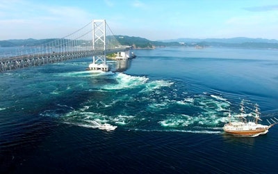 Video article 1:53
An Aerial View of the Powerful Whirlpools of the Seto Inland Sea! What Causes These Whirlpools, and Where Is the Best Place to View Them? Let’s Find Out!
Nature Travel- 508 plays
- YouTube
Drone Footage of the Whirlpools of the Seto Inland Sea and the Onaruto Bridge! The video that we'll introduce today is called "[Aerial View] Seto Inland Sea Whirlpools|Drone Footage of Onaruto Bridge [4K]|Tokushima to Awaji Island, Hyogo" (【絶景空撮】瀬戸内海・渦潮 ドローン空撮 大鳴門橋【4K】(四国徳島〜兵庫淡路島)). The video was created by "winteroptix." It shows beautiful drone footage of the whirlpools of the Seto Inland Sea and the Onaruto Bridge. You can enjoy a beautiful view of the Seto Inland Sea, the Naruto whirlpools, and the magnificent scenery of the Onaruto Bridge, all in one video! The Onaruto Bridge and Whirlpools of the Seto Inland Sea Photo:Onaruto Bridge Onaruto Bridge (大鳴門橋,Onarutokyo) is a suspension bridge that connects Fukurahei, Minamiawaji City, Hyogo Prefecture and Tosadomariura, Naruto Town, Naruto City, Tokushima Prefecture. The bridge is 1,629 meters long and 25 meters wide, and its main tower is 144.3 meters tall. Honshu-Shikoku Bridge (本州四国連絡船橋, Honshushikokurenrakukyo), Onaruto Bridge, and Akashi Kaikyo Bridge (明石海峡大橋, Akashikaikyoohashi) are 3 of the most crucial traffic routes connecting Honshu (本州) and the Shikoku Region (四国地方,Shikokuchiho). Since the bridges span the sea, they are often closed to traffic due to wind speeds, so be careful when passing through. Onaruto Bridge is a motorway so you cannot cross it by foot, bicycle, or scooter. There used to be a ferry company called Naruto Ferry that ran between the Shikoku Region and Awaji Island (淡路島, Awajishima), but it is now out of business. There is a plan to add a railroad to Onaruto Bridge and enable the Shikoku Shinkansen to cross the Seto Inland Sea in the future, so you may one day be able to go to the Shikoku Region by bullet train! The Amazing Naruto Whirlpools Near Onaruto Bridge Photo:Naruto Strait The Naruto whirlpools are whirling tides of water that appear in the Naruto Strait (鳴門海峡, Narutokaikyo). You can observe them at around 0:07 in the video. Some of these whirlpools have a diameter of 20 meters, making them the largest whirlpools in the world. The Naruto whirlpools appear due to currents from the Seto Inland Sea and the Kii Channel (紀伊水道, Kiisuido) violently colliding with one another near Naruto. The area around Naruto has a wide tidal range, with the difference between the high tide and low tide going up 1.5 meters during the spring, and its current is said to be the fastest in Japan. The Naruto Strait is said to be one of the world’s three major currents, along with Italy's Strait of Messina and Canada’s Seymour Narrows. Famous Tourist Spots to View the Whirpools Photo:Naruto whirlpools There's a sidewalk called "Uzu no Michi (渦の道) on Onaruto Bridge, which hangs over the Seto Inland Sea. From here, you can look down at the Naruto whirlpools from the bridge. The area gets many tourists and is famous for being instagrammable! The entry fee is 510 yen for adults, 410 yen for junior high and high school students, and 260 yen for young children. There's also the Onaruto Bridge Museum Eddy (大鳴門橋架橋記念館エディ, Onarutokyo kakyo kinenkan eddy) nearby, so consider dropping by during your visit. The bridge is lit up at night, providing a a beautiful view that you won't be able to see during the day. If you want to observe the Naruto whirlpools up close, we highly recommend taking a cruise on the whirlpool sightseeing boats run by Uzushio-kisen. The cruise ships go near the whirlpools, so you can experience the thrilling natural phenomenon! If you're prone to seasickness, be sure to take some seasickness medicine beforehand! Roadside Station Uzushio (道の駅うずしお, Michinoekiuzushio) and Naruto Park (鳴門公園, Narutokoen) on Awaji Island are great places to stop and rest. Tokushima Prefecture is full of tourist attractions, such as the Awa Odori Festival (Awa Dance Festival), Tokushima Ramen, and temples included in the "88 Shikoku Temples"! Summary of the Naruto Whirlpools of the Seto Inland Sea Source :YouTube screenshot Today, we introduced drone footage of the whirlpools of the Seto Inland Sea and Onaruto Bridge. If this article/video have you interested in the Naruto whirpools, be sure to visit Tokushima prefecture! 【Tripadvisor】Seto Inland Sea https://www.tripadvisor.com/ShowUserReviews-g298561-d554137-r138282192-Setonaikai-Hiroshima_Hiroshima_Prefecture_Chugoku.html 【Tripadvisor】Onaruto Bridge https://www.tripadvisor.com/Attraction_Review-g678355-d1384640-Reviews-Onaruto_Bridge-Naruto_Tokushima_Prefecture_Shikoku.html -
 Video article 1:49
The Dynamic Eruption of Shinmoedake on Mt. Kirishima. The Invaluable Footage of this Volcanic Eruption in Kagoshima Prefecture Shows the Fury of Nature That Stretches Far Beyond the Human Imagination
Nature- 1.2K plays
- YouTube
The Eruption of Shinmoedake, Mt. Kirishima Before we begin, please watch the video "The moment of a volcanic eruption! Shinmoedake “Spouting Volcanic Bombs” Kirishima Mountain Range(火山噴火の瞬間!新燃岳「噴出す火山弾」霧島連山)". This is a video of the powerful eruption of Shinmoedake, Mt. Kirishima in Kagoshima Prefecture(鹿児島県,Kagoshimaken). You can feel the fury of nature that stretches far beyond the human imagination by watching the video of the dynamic eruption. We will introduce Shinmoedake, Mt. Kirishima through the video with this article, so be sure to follow along. What Kind of Place Is Shinmoedake? Photo:Kirishima Geopark Kirishima Mountain Range is a group of volcanoes that stretches from Miyazaki Prefecture (宮崎県,Miyazakiken) to Kagoshima Prefecture in Southern Kyushu (南九州,Minami-kyushu). Shinmoedake, which is introduced in the video, is 1,421 meters above sea and is located almost halfway between Karakunidake (韓国岳,Karakunidake), the highest mountain in Mt. Kirishima, and the sacred Mount Takachiho (高千穂峰,Takachihonomine) in the east. The area surrounding the peak of Shinmoedake consists of craters and calderas, which are hollows in the ground created by volcanic activity, and it stretches over Kirishima City, Kagoshima Prefecture, while the area surrounding the ridge line stretches over Kobayashi City (小林市,Kobayashishi), Miyazaki Prefecture. As you can see in the video, volcanic activity still continues actively in Shinmoedake. The History of Volcanic Activity in Shinmoedake Photo:Shinmoedake The history of Shinmoedake’s volcanic activity is thought to stretch back about 150,000 years. Shinmoedake is a volcano that has violent eruptions called "Plinian eruptions," which produce enormous amounts of volcanic products and energy, and it has been responsible for massive disasters such as the Kyoho Eruption and the Bunsei Eruption in the Edo period (1603-1868), as well as the Showa Eruption of 1959. From existing research, we know that the volcanic eruption during the Showa period was caused by an explosion of water vapor, not magma. The Current State of Shinmoedake Source :YouTube screenshot Shinmoedake’s volcanic alert level is currently level 3 out of 5, and the damage from the falling ash is also immense. Mountaineering on the volcano is also restricted, so the effect on tourism is quite large as well. There are also volcanoes other than Shinmoedake in Kyushu such as Sakurajima (桜島,Sakurajima) and volcanic eruption alerts come frequently, so it is important to check the newest information as often as possible. This video is of Shinmoedake, Mt. Kirishima in January 2011. You can see bright red lava bursting out and rocks flying through the sky from 0:15. You can also see lightning called “volcanic thunder” flash across the rising pitch-black ashes from 1:03. Summary of the Video on Shinmoedake's Volcanic Eruption This video of the volcanic eruption that we introduced is barely 2 minutes long, yet it is a powerful piece of footage that conveys the fury of nature. The volcanic alert level of Shinmoedake, Mt. Kirishima is still extremely high and its activities are being observed carefully. If you are ever to travel close to Mt. Kirishima in Kagoshima, be careful and be prepared! 【Tripadvisor】Shinmoedake https://www.tripadvisor.com/Attraction_Review-g1022935-d1384894-Reviews-Mt_Shinmoe-Kirishima_Kagoshima_Prefecture_Kyushu.html -
Video article 6:57
Beautiful autumn color animation of "Koankyo hot spring" in Yuzawa, Akita, which is famous as the most scenic spot in Tohoku! A mysterious sightseeing spot with precipitous cliffs and the sight of hot springs bubbling up from the riverbank!
Nature- 313 plays
- YouTube
Autumn color video introduction of "Koankyo Onsen" in Yuzawa City, Akita Prefecture This video, titled "JG☆☆☆8K HDR Akita Oyasu Onsen Gorge in Autumn," shows footage of Oyasu Gorge, a spectacular place to enjoy the autumn colors in Yuzawa City, Akita Prefecture. Oyasukyo Daifunto, located within Kurikoma Quasi-National Park (栗駒国定公園, Kurikoma Kokuteikoen), is a scenic spot that provides beautiful seasonal scenery. Coming into sight at 0:14 in the video, is a breathtaking scene of the fiery autumnal foliage. During the peak of the autumn foliage, there are events that light up the area, and so many tourists visit, filling up the nearby parking lots. Enjoy the entrancing scenery and the mystical views of hot springs shown in the video. Oyasukyo Onsen, Akita Photo:Akita Prefecture・Oyasu Gorge Oyasukyo Onsen, which offers a spectacular view of steam rising from the gorge, is a popular tourist spot in the Tohoku region. has a long history and prospered as a therapeutic bath in the Edo period (1603-1868). It takes about 50 minutes to get to by bus from Yuzawa Station on the Ou Main Line by use of the local Ugo Transport Bus. At 2:20 in the video, you can hear the sound of the hot springs bubbling up from the Minase River (皆瀬川, Minasegawa). Oyasu Gorge Geyser (小安峡大噴湯, Oyasukyo Daifunto), where boiling water and steam are ejected, is the most famous hot spring in the Oyasu Gorge area. There is a promenade around the 60-meter-high V-shaped valley in Oyasu Gorge, where you can enjoy hiking while admiring the autumn colors. You can also see the beautiful red and yellow mountains in this video. Be sure to step out of the hot spring town and visit Fudo Falls (不動滝, Fudotaki) and Yakushi Falls (薬師滝, Yakushitaki) as well. Where to Stay at Oyasukyo Onsen Photo:Hot springs If you're looking for a great way to spend your time, try staying at one of the inns or hotels at Oyasukyo Onsen, Akita, when the autumn leaves are about. Hotels such as Motoyu Kurabu, where you can enjoy excellent food and relaxing hot springs, and the warm and inviting Oyado Yamanosuna, are perfect for those looking to make their trip special. Ryokan Tarobee, Hotel Matsubakan, Abe Ryokan, Komakusa, and Yadoya Sanpei are all popular Japanese ryokan in the area. Oyasukyo Onsen is a sodium-chloride, sulfuric acid, alkaline hot spring. There are many inns and hotels in the vicinity where you can take a day trip to the hot spring. The day after your stay, you may want to venture out and check out Ishinomaki Seafood Market (石巻海の市, Ishinomaki Uminoichi) and other popular tourist destinations after a good night’s sleep. Tourist Center (観光物産館, Kankobussankan), Oyasu Gorge Icicles (小安峡大つらら, Oyasukyo Daitsurara), Tokotonyama Campsite, Kawarayu Bridge (河原湯橋, Kawarayuhashi), Mt. Magusa (秣岳, Magusadake), Oyasu Gobansho Remains (小安御番所跡, Oyasu Gobanshoato), and Kijiyama Plateau (木地山高原, Kijiyamakogen) are some of the many popular sightseeing spots nearby. If you're interested in Japan's public baths, try visiting Oyasukyo Onsen. You can enjoy the beautiful autumnal foliage here as well. Summary of Oyasu Gorge Photo:Akita Prefecture・Oyasu Gorge Oyasukyo Onsen in Akita Prefecture, is a popular out-of-the-way place with breathtaking scenery and colorful autumn leaves. Check out the beautiful autumnal foliage at 0:14 in the video. You can enjoy the beautiful scenery of Japan first, and get into the mood for traveling! 【Official Website】Kurikoma Quasi-National Park – Miyagi Prefecture https://www.pref.miyagi.jp/soshiki/kohou/foreign.html 【Official Website】Oyasukyo Onsen, Minase, Yuzaka City, Akita Prefecture https://www.oyasukyo.jp/ -
Video article 0:53
Mt. Norikura: At an Altitude of Nearly 10,000 Feet, Boasting 60-Foot-Tall Snow Walls and Autumnal Leaves, Its a Great Place to Enjoy Nature in Every Season in Nagano and Gifu Prefectures!
Nature Travel- 230 plays
- Vimeo
Norikura-dake" in Nagano and Gifu Prefectures, Introduction of mountain climbing video This video, titled “Mt. Norikura in one minute” (乗鞍岳登山を一分でまとめてみました。), was created by “odenkuuuuuuun.” It introduces Mt. Norikura, a part of the Hida Mountains, or Northern Alps. Mt. Norikura is one of "Japan’s Top 100 Famous Mountains," and stretches through Nagano Prefecture’s Matsumoto City to Gifu Prefecture’s Takayama City. The video summarizes "odenkuuuuuuun's" climb of Mt. Norikura in September. Although the video is only 54 seconds long, it’s brimming with the allure of Mt. Norikura. Matsumoto Prefecture・Gifu Prefecture’s Mt. Norikura Photo:Summit of Mt. Norikura Mt. Norikura is a complex volcano encompassing 7 lakes and 8 plains. The highest of its 23 peaks is Kengamine Peak, at a height of 10,000 feet. The mountain was chosen as one of "Japan’s Top 100 Famous Mountains," and its popularity extends to foreign visitors as well. Its most recent eruption is said to be the Mt. Ebisu eruption over 2000 years ago. The mountain lies in the Hida Mountains. At the top of the mountain is the Norikura Shrine (乗鞍神宮, Norikura jingu), which has been a place of worship since long ago. This can be seen from 0:47 in the video. In the Shinshu Province, the mountain is also known as “Asahidake,” due to it being the first mountain touched by the light of the morning sun. (朝日, Asahi "Morning sun," 岳, dake "Mountain/Peak"). The starting point of the trail is Tatami-daira, which is 8,800 feet above sea level, and it takes about 1.5 hours to reach the summit, depending on which trail you take, making it an easy climb even for beginners. However, at an altitude of 10,000 feet, the weather can be quite unpredictable, and the temperature is low year round, so you'll need to wear warm clothes. Mt. Norikura’s popular trekking courses include the route from Tatamidaira to Kodamadake to Kengamine (approximately one and a half hours), and the route from the Norikura Kogen highlands to the peak of Mt. Norikura (approximately five hours and forty minutes). There are hiking courses available as well. Behind Tatamidaira is a national park where alpine flora and fauna are blooming, and visitors can enjoy the beautiful sight of the flower gardens while strolling around the lake or through the promenade. Autumn at Mt. Norikura provides stunning views of autumn leaves. The peak viewing period is from mid-September to early October. During the summer season, July to September, buses begin operating early in the morning, enabling visitors to be able to enjoy the sunrise from the 10,000 ft. tall mountain peak. It's great for taking pictures. Be sure to post them on your Instagram! On Mt. Norikura, there are a few mountain huts, so climbs with overnight stays are also possible. Many of these huts are fully-equipped with facilities such as baths, so visitors can feel as if they're resting at a hotel or ryokan. For the sake of nature preservation, access to Mt. Norikura by personal vehicles is limited, so you will need to use a tourist bus, shuttle bus, or taxi to get there. As the entrance of private cars is prohibited, of course, the usage of the Tsurugaike Parking Lot is not permitted. Visitors can head to Mt. Norikura from the Honokidaira Bus Terminal or the Hirayu Onsen Bus Terminal. The bus terminals can be found at Hirayu Onsen of the Okuhida Onsen Village. Roads leading to Mt. Norikura include the Norikura Skyline (乗鞍スカイライン, Norikura sukairain) from Gifu Prefecture, as well as the Norikura Eco Line from Nagano Prefecture. Travelling on road bikes or bicycles is also possible. Cycling events are held as well, such as the “Mountain Cycling in Norikura,” and the “Norikura Skyline・Cycling Hill Climb. Sightseeing Around Mt. Norikura Photo:Mt. Norikura Snow Wall Norikura Kogen highland’s Norikura Skyline is open from mid-May to mid-June, visitors can view the snow wall "Yuki no Kairo" (雪の回廊, yuki no kairo) as well. At its highest, the snow wall can reach up to 60 feet, towering over the Norikura Skyline. Visitors can even walk amongst this magnificent sight. As seen from 0:17, snow remains on Mt. Norikura even in September, and summer skiing, where visitors climb the mountain on their own and ski at the peak, is also possible. Of course, in winter, ski resorts are opened as well, and visitors can enjoy winter sports such as skiing and snowboarding. Mt. Norikura also boasts the 50-meter “Sanbon Falls (三本滝, Sanbon-daki), which is counted among "Japan’s top 100 waterfalls." It has been a place of worship since olden times, and it is said that ascetics come to practice discipline at this waterfall. The “Starry Sky Observation Event” at Tatamidaira is also popular. Visitors can gaze up at the night sky full of stars while listening to the guide’s explanation of the sights. Summary of Mt. Norikura What'd you think of this article about Mt. Norikura? From the video, you can see the mountain from the view of a mountain climber, but you don't need to be a mountain climber to enjoy the natural beauty of Mt. Norikura. Although only 54 seconds long, the video is full of the sights and sounds of Mt. Norikura, so definitely check it out! 【Official Website】Mt. Norikura, Norikura Skyline Official Site https://norikuradake.jp/en.html 【Tripadvisor】Mt. Norikura https://www.tripadvisor.com/Attraction_Review-g298102-d2318270-Reviews-Mt_Norikura-Chubu.html -
Video article 1:10
Spectacular Views for Only Two Weeks of the Year! A Dragon's Eye on the Surface of the Lake in Kagami-Numa, Akita Prefecture
Nature- 44 plays
- YouTube
This video, titled "A Dragon's Eye That Appears at Hachimantai in Early Summer: Akita-Iwate Border [nippon.com]" (初夏の八幡平に現れる「ドラゴンアイ」:秋田・岩手県境 | nippon.com), was released by "nippon.com" Hachimantai, which lies near the border of Akita and Iwate prefectures, is a mountain range in the northern part of the Ou Mountains dotted with rolling lakes and swamps at 1,600 meters above sea level. One of the lakes, Kagami-numa in Senboku City, Akita Prefecture, is called "Hachimantai Dragon Eye" because the snow on the surface of the lake melts into a doughnut shape, making it look like the eye of a dragon. The dragon's eye is only visible for two weeks, and heavy equipment is required to climb the mountain during the snowy season. Seeing a scene like the one in this video is extremely rare, so it's a must-see! -
Video article 4:31
Genbikei Gorge, a Historically Famous Valley in the Midst of Nature! Feel the Excitement in a Land Full of Natural Beauty!
Nature- 48 plays
- YouTube
This video, titled "Drone Footage|Ichinoseki City, Iwate Prefecture|Genbikei Gorge" (ドローン撮影 岩手県一関市 厳美渓), was released by "Iwate Drone Movies" (岩手ドローンムービー). This video introduces Genbikei Gorge, which has been designated a place of scenic beauty and a natural monument. Genbikei Gorge in Ichinoseki City, Iwate Prefecture is the name of a section of ravine in the Iwai River and has long been a popular scenic spot. It is said that Date Masamune, a famous military commander in the Warring States period of Japan, would have praised the valley, and many tourists visit the valley to feel the history of Japan. In this video, you can see the overwhelming grandeur of nature in Genbikei Gorge from the sky, so be sure to check it out. -
Video article 5:08
Akiyoshidai and Akiyoshido Cave, Two of the Most Beautiful Spots In... Is This Actually Japan?! Be Amazed by the Mystery and Grandeur of Japan's Nature!
Nature- 140 plays
- YouTube
This video was shot by "STARstreamer YOSUKE" and is titled "[Best View in Yamaguchi Prefecture] Akiyoshidai Benten Pond in Akiyoshidai 4K." This video introduces Akiyoshidai, one of the largest karst plateaus in Japan, and Akiyoshido Cave, one of the largest natural limestone caves in Japan, located underneath the plateau. Both Akiyoshidai and Akiyoshido Cave have been designated as Special Natural Monuments since 1964. The mystique and grandeur of nature and the complete change between scenery above ground and below ground is truly impressive, making it a place to throw on your bucket list. This video shows actual footage of Akiyoshidai and Akiyoshido Cave, so be sure to check it out! -
Video article 6:34
Unkai Terrace - Experience a Sea of Clouds Flowing Like the Ocean! Powerful Views You Won't Find in Everyday Life. It's Truly a Sight to Behold!
Nature- 88 plays
- YouTube
This video, titled "[Hoshino Resort Tomamu] Unkai Terrace - Sea of clouds flowing into the sea of clouds (Unkai Terrace)" (【星野リゾート トマム】雲海テラス 流れ込む雲海<絶景> Unkai Terrace), was released by Hoshino Resort Tomamu (official). This video introduces Unkai Terrace at the luxury resort "Hoshino Resort Tomamu" in Hokkaido. Unkai Terrace is a superb spot at the Hoshino Resort Tomamu in Hokkaido where you can see the sea of clouds from above, and the overwhelming view of the grandeur of nature is nothing short of breathtaking. The probability of seeing the sea of clouds itself is low, but it is a view that makes you want to see it at least once in person. This video shows the actual view of the sea of clouds from Unkai Terrace, so if you're interested, be sure to check it out. -
Video article 4:52
Introducing the Popular Family-Friendly Takenohama Beach! Enjoy the Crystal Clear Waters of Toyooka, and Spectaculars Views of the Ocean and Mountains!
Nature- 74 plays
- YouTube
This video, titled "Japan - Aerial Shot - Takeno Beach ・ 日本 - 竹野浜ビーチ," was released by "Taru Farias - Japan Travel." In the video, you can see Takenohama Beach at the sea in Toyooka in Hyogo Prefecture. The sea at Toyooka is clear and blue even from the sky, and it is crowded with many swimmers. The view from the nearby mountains is also superb. Be sure to check it out in the video! -
Video article 10:18
The Autumn Leaves Reflected in the Water of Mishakaike Pond in Nagano Prefecture Are Out of This World! Watch the Video to See a Spectacular View of Japan That's Sure to Blow You Away!
Nature- 436 plays
- YouTube
長野県茅野市・御射鹿池とは? こちらの動画は「Yatsugatake21_4K_Japan」が公開した「4K 絶景紅葉「晩秋の御射鹿池」癒し自然風景映像 G線上のアリア/ Japan Autumn Nature Relaxation Video / Air on the G String」だ。 御射鹿池は、長野県茅野市の蓼科高原・標高1,500メートルにあるため池だ。 大自然の中に突如として現れるこの池は、四季折々に美しく姿を変える観光地だ。 御射鹿池周辺の八ヶ岳中信高原国定公園は、長野県と山梨県にまたがる国立公園に指定されている。 この動画は、御射鹿池の秋の紅葉の様子を4K画質で撮影したものである。 楽曲「G線上のアリア」に共にご覧になれる美しい紅葉したカラマツ林は、時間を忘れる癒しの時間を過ごせる。 新緑に紅葉など!四季折々の絶景が魅力 長野県茅野市・御射鹿池は、日本画家である東山魁夷の作品「緑響く」のモチーフになっていることで知られている。 新緑の季節に天気が良ければ、東山魁夷が見た風景と同じ景色が観光できるかもしれない。 新緑の景観を見るハイキングは、御射鹿池の楽しみ方のひとつだ。 また、その他にも「死ぬまでに行きたい!世界の絶景 日本編」で紹介されたり、農林水産省が選定する「ため池百選」に指定されたりと、観光地として人気が上がっている。 御射鹿池の最大の魅力は、紅葉の時期の景勝である。 例年10月中旬から下旬にかけて御射鹿池を含む蓼科高原エリアは紅葉の見頃を迎える。 インスタ映えスポットの隠れた名所なため、紅葉時期の撮影を狙って観光してみるのもよいだろう。 御射鹿池の歴史と背景 長野県茅野市・御射鹿池を含む蓼科高原は、冷害の影響が激しく農作物が育ちにくい気候である。 御射鹿池は、流れてくる冷たい水を農作物に使えるほどの水温にするため、作られた池だ。 一時的にため池で水を溜めることで適温まで水が温まる。 このような背景で作られた御射鹿池だが、その名の由来は、長野県にある諏訪大社の神事「御射山御狩神事」からきていると云われている。 長野県茅野市・御射鹿池の魅力まとめ 長野県茅野市・御射鹿池は、東京都心からでも電車やバスなどで3時間弱ほどで観光に行くことができる。 また日帰りの観光ツアーなども存在している。 御射鹿池を観光するおすすめの季節は紅葉の時期だ。 動画で撮影されている美しく紅葉した木々が御射鹿池の水面に映るさまを直接見る事ができる。 御射鹿池以外でも蓼科高原は紅葉が美しいので、車で回って観光してみるのもよいだろう。 -
Video article 11:19
Enjoy a Cup of Pure Bliss in the Great Outdoors! Enjoy an Out-of-the-Ordinary Experience With Coffee Brewed From the Spring Water of Oike Spring in Oita Prefecture
Nature- 35 plays
- YouTube
This video, titled "[Hiking] Coffee From a Spring - A Walk in the Woods and a Quiet Time" (【ハイキング】湧き水でコーヒー - 森林散策と静かな時間), was released by "Morinone Channel" (モリノネチャンネル). Wouldn't it be wonderful to make coffee from a clean spring in the mountains and take in the magnificent scenery? The Oike Spring Group in Yufu City, Oita Prefecture, introduced in the video, is an area at the source of the Aso River. The rainfall on Mt. Kurodake is filtered underground over a long period of time to produce clean spring water. It's very comfortable and cool even in summer as it is located 850 meters above sea level. Sitting under a tree, boiling water from the spring with a portable stove, and drinking coffee will refresh your body and mind. -
Video article 11:06
What to Do in Tomakomai in a Day, 30 Minutes from the Airport
Travel Nature Local PR- 34 plays
- YouTube
■Contents Introduction Why Tomakomai Is Chosen as a Base for a Hokkaido Trip A Port Town Where the Gateways of Air and Sea Overlap Major Spots Divided Between the Airport Side and the City Center Why Tomakomai Has So Many Places You Can Enter for Free A One-Day Model Itinerary for Tomakomai Start the Morning With the Lake and the Observation Deck Head for the Space Station and the Port Photo Spot in the Afternoon Travel Times Until Evening and How to Rearrange the Plan The Lake and Airplane Views at Michi-no-Eki Utonai-ko An Observation Deck With a 360-Degree View From the Rooftop Walking the Nature Trail Along the Shore Local Seafood and Regional Goods Inside the Building Michi-no-Eki Utonai-ko Basic Information Inside a Space Station at the Mir Exhibition Hall Why There Is a Backup Unit of Mir in Tomakomai What You Can See Inside, From Control Panels to Living Quarters Enjoying the Planetarium and the Main Exhibition Room Too Tomakomai Science Center Basic Information Tomakomai Seen From Two Heights, the Port and the Hill The PORT OF TOMAKOMAI Monument at Kirakira Park Mount Tarumae and the Sea From the Midorigaoka Park Observation Deck The Factory Lights That Emerge After Dark Basic Information for the Two Parks Port Town Flavors and Souvenirs to Try in Tomakomai A Plate of Hokki Clam, the Taste of a Port Town The Soft Serve That Placed at a Grand Prix Choosing Yoitomake and Haskap Sweets at the Mitsuboshi Main Store Basic Information for Each Shop How to Pick a Season When You Cannot Decide When to Go When Can You See Swans Mount Tarumae and the Lakeshore at Their Best in the Green Season Temperature Differences by Season and What to Wear Wider Sightseeing With Tomakomai as Your Base A Half-Day Plan Out to Lake Shikotsu The Route Toward Shiraoi and Noboribetsu Short Plans That Fit Into a Layover at the Airport Getting to Tomakomai and Around the City Traveling From New Chitose Airport by Car, JR or Bus Getting Around After Arriving by Ferry Points to Watch When Getting Around by Public Transportation Frequently Asked Questions About Visiting Tomakomai Can You Visit Tomakomai From New Chitose Airport as a Day Trip Can You Get Around the Sights in Tomakomai Without a Car Are There Places to Enjoy on Rainy or Cloudy Days Can You Fill a Whole Day With Children Along When Can You See Swans at Lake Utonai Ways to Spend a Day in Tomakomai, Chosen by What You Want もっと見る Introduction Hokkaido is the island at the northern end of the Japanese archipelago. Tomakomai, in its southwestern part, sits about 30 minutes by car from New Chitose Airport, and it is also a port town that serves as a gateway by sea, with ferries arriving and departing. Here you will find Lake Utonai, registered under the Ramsar Convention, a real backup unit of the space station Mir, and the view of Mount Tarumae and the ocean from a hill. This article gathers a model itinerary for Tomakomai and the highlights of each spot, based on a route actually covered in a single day. Photo: Tomakomai, Hokkaido / A Pacific port town where greenery, factories and harbor sit side by side Why Tomakomai Is Chosen as a Base for a Hokkaido Trip You may have seen the name Tomakomai on expressway signs or on ferry destination boards without ever getting off and walking around. Tomakomai is a transport hub, easy to reach from New Chitose Airport and served by ferry routes linking ports across Honshu. Photo: Tomakomai West Port Ferry Terminal / Hokkaido's sea gateway, linked by ferry to ports across Honshu A Port Town Where the Gateways of Air and Sea Overlap New Chitose Airport is Hokkaido's gateway by air. From there to central Tomakomai is 22.7 km on ordinary roads, roughly 30 minutes by car. You get there without ever using the expressway, so the afternoon of your arrival day, or the morning of your departure day, turns straight into sightseeing time. The other gateway is the Tomakomai West Port Ferry Terminal. Four routes serve it, running to Hachinohe, Sendai, Nagoya and Oarai, and this is the port where travelers who have crossed from Honshu with their cars first set foot. Few cities in Hokkaido act as an entrance both by air and by sea. If you are coming from overseas, the usual route is to connect to a domestic flight at a major airport such as Tokyo, Osaka or Nagoya and fly into New Chitose Airport. Travel time varies with your point of departure and your flight, so check connection times in the airline timetables. Major Spots Divided Between the Airport Side and the City Center The sights of Tomakomai fall into two broad clusters. The Uenae district, nearer the airport, has Lake Utonai and the roadside station on its shore, while the city center side lines up the Tomakomai Science Center, Kirakira Park by the port, and Midorigaoka Park up on the hill. Because the sights are split between the airport side and the city center side, you can head for the lake first with the airport still fresh behind you, then work your way down into town, and build a day that never doubles back. On a day when you arrive at the port by ferry, follow the same route in reverse and you come out at the airport. Why Tomakomai Has So Many Places You Can Enter for Free Sightseeing in Tomakomai is easy on the wallet. At the Tomakomai Science Center, the main exhibition room, the Mir Exhibition Hall and the planetarium are all free to enter, and the Midorigaoka Park observation deck is free as well. Neither Kirakira Park nor Michi-no-Eki Utonai-ko charges admission. Most of the main spots introduced here are free to enter. A One-Day Model Itinerary for Tomakomai Before going into what each spot holds, here is the shape of the day as a whole. Each sight is explored one by one from the next section onward. Start the Morning With the Lake and the Observation Deck The first stop of the day is Michi-no-Eki Utonai-ko, on National Route 36. A michi-no-eki is a roadside rest facility you can drop into partway through a journey, where local produce, souvenirs and light meals are also on offer. It opens at 9:00, so if you pick up a rental car at New Chitose Airport and drive straight south, you arrive right around opening time. Here you go up to the rooftop deck to look out over the lake, then walk a short stretch of the trail along the shore. Allowing about an hour for the view and the walk together gives you a pace that never feels rushed. 【Video】2:37〜 The lake and a passenger plane seen from the observation deck at Michi-no-Eki Utonai-ko If you want to browse local products at the shop or grab something light at the food court, add another 30 minutes or so. Head for the Space Station and the Port Photo Spot in the Afternoon After leaving the lake, drive toward the city center and go into the Tomakomai Science Center. It is open from 9:30 to 17:00, so arriving early in the afternoon leaves you time for both the Mir Exhibition Hall and the planetarium. Figure on one hour to an hour and a half for the visit. From there, drop down toward the sea to Kirakira Park. Photograph the monument with the moored ferries behind it and spend around 30 minutes. Finish by going up to the Midorigaoka Park observation deck on the hill, where Mount Tarumae, the city and the ocean all come into view at once. Travel Times Until Evening and How to Rearrange the Plan Travel times within the city change with the route and the time of day. Checking the day's travel times on a map app before you set out keeps the second half of the plan from falling apart. On a day when you only have half a day, narrow it down to two places, the lake and the science center. If photography is your aim, rearranging the day around the port and the hill works well. Time your climb to the Midorigaoka Park observation deck to sunset and you can stay on after the sun has gone down, since it is open until 21:00 from April 20 through October 31. The Lake and Airplane Views at Michi-no-Eki Utonai-ko Many people probably think of Lake Utonai as a place for birdwatching. Stand there, though, and you notice a combination you cannot see anywhere else, created by the closeness of the lake and the airport. Photo: Lake Utonai / A Ramsar-listed wetland for birdwatching, with New Chitose Airport flights crossing overhead An Observation Deck With a 360-Degree View From the Rooftop The building at Michi-no-Eki Utonai-ko has three floors, with an elevator up to the outdoor space on the third. The second floor is an indoor observation room, a place to view the lake through glass. Step outside on the third floor and climb one more flight of stairs to the rooftop deck, and the view opens up a full 360 degrees. What you see, in order, is the parking lot and National Route 36 in the foreground, grassy lakeshore beyond that, and the surface of the lake spreading out at the very back of your line of sight. New Chitose Airport is close by, so you may catch sight of an airliner crossing the far side of the lake as it loses altitude. Flight paths change with the time of day and the wind direction, so there is no guarantee you will see one. Walking the Nature Trail Along the Shore If you want to get down to the water's edge, there is the nature trail of the Wild Bird Society of Japan's Utonai-ko Sanctuary. Observation points are set out along the way, including the Common Sandpiper terrace, the alder terrace, the Greater White-fronted Goose terrace, the grassland observation hut and the barrier-free course, on a route that takes you through woodland, grassland and waterside. Some facilities are currently out of use, so check the latest status before you set out. The path is surfaced with wood chips, so even a short walk leaves you feeling you have been out in the forest. The sanctuary's nature center is open Saturdays, Sundays and public holidays from 9:30 to 16:30. If you visit on a weekday, the neighboring Utonai-ko Wildlife Protection Center serves as the point of contact. It closes every Monday and is open from 9:00 to 17:00. Local Seafood and Regional Goods Inside the Building Inside there is a local products corner and a direct sales counter for farm, forest and marine products, alongside takeout windows where you can eat on the spot. There is a food court too, so on a day when you set out without breakfast, one option is to simply have a meal here. The toilets and the car park are open 24 hours, and inside the building there is a tourist information and luggage counter, a kids' corner where small children can play, and a nursing room. On a day of long-distance driving with small children, this roadside station makes the first rest stop. Michi-no-Eki Utonai-ko Basic Information Michi-no-Eki Utonai-ko 【Address】156-30 Aza-Uenae, Tomakomai, Hokkaido 【Phone】0144-58-4137 【Hours】9:00-18:00 (March-October), 9:00-17:00 (November-February) 【Closed】New Year period (December 31-January 2) 【Admission】Free 【Time needed】1 hour to 1 hour 30 minutes 【Parking】93 standard cars, 10 large vehicles, 2 accessible spaces 【Official Website】Tomakomai City tourist information, "Michi-no-Eki Utonai-ko" ※Prices and opening hours are as of September 2026. Please check the official website for the latest details. Inside a Space Station at the Mir Exhibition Hall A real space station, sitting in a city better known as an industrial town. That fact alone is surprising enough, but what follows is more so. The exhibit is not something you only view from the outside, because you can go inside and look around. COOLJAPANVIDEOS Why There Is a Backup Unit of Mir in Tomakomai Mir was a space station launched by the former Soviet Union. Its core module was launched on February 19, 1986, and observation and experiment modules were added to it one after another. In April 1996 it became the largest space station in history up to that time, and on March 23, 2001 it came down off the coast of New Zealand in the South Pacific, ending 15 years of operation. What stands in Tomakomai is the actual backup unit. Tomakomai received it as a donation from Iwakura Corporation in 1998, and the Mir Exhibition Hall opened the following December, in 1999. It is not the craft that actually went into space, but it is a genuine article built to the same design, so the interior remains exactly as it was. 【Video】5:36〜 Walking through the inside of the Mir Exhibition Hall What You Can See Inside, From Control Panels to Living Quarters Two modules are on display, the core module Mir and the astrophysics observation module Kvant. Mir means peace in Russian, and Kvant means quantum. The core module weighs 20.4 tons and is 13.13 m long, with a pressurized section of 90 cubic meters where people could live, holding the life support system and the power system driven by solar panels. Kvant weighs 11.5 tons and is 5.8 m long, and it carried telescopes, various observation instruments, gyroscopes and an oxygen generator. There are six docking ports on the outside of the craft, where other modules and supply vessels could connect. Go inside and you find a control room lined with automatic control panels, with the living quarters continuing behind it. The private cabin where a cosmonaut slept is about the size of half a tatami mat, and the sleeping bag was fixed to the wall. A toilet and faucet adapted to zero gravity, a shower designed so the water does not fall away, an oven and a refrigerator, and even a treadmill for preventing muscle loss all remain. Standing in front of the real thing, you understand why the same daily life as on the ground had to be provided in a form so unlike it. Enjoying the Planetarium and the Main Exhibition Room Too The same building also holds a planetarium with a dome 10 m across. It has 84 seats, and a projector made by Goto Optical Manufacturing projects about 6,500 fixed stars down to magnitude 6.25. The main exhibition room, the Mir Exhibition Hall and the planetarium are all free. When rain or strong wind wrecks your plans, this facility, which works entirely indoors, is the first place to head for. Tomakomai Science Center Basic Information Tomakomai Science Center (Mir Exhibition Hall) 【Address】3-1-12 Asahicho, Tomakomai, Hokkaido 【Phone】0144-33-9158 【Hours】9:30-17:00 【Closed】Every Monday (the next weekday if Monday is a public holiday), New Year period (December 29-January 3) 【Planetarium screenings】Twice a day on weekdays, at 14:00 and 15:30; three times a day on Saturdays, Sundays, public holidays and the spring, summer and winter school holidays, at 11:30, 14:00 and 15:30. Each screening seats 40, with priority given to advance bookings. Reservations open the month before the screening date, and same-day booking is also possible 【Admission】Free (main exhibition room, Mir Exhibition Hall and planetarium all included) 【Time needed】1 hour to 1 hour 30 minutes 【Parking】Free. 20 cars, 4 large buses (large buses must contact the center in advance) 【Official Website】Tomakomai Science Center ※Admission and opening hours are as of September 2026. Screenings are suspended on some days for maintenance, so please check the official website for the current schedule. Tomakomai Seen From Two Heights, the Port and the Hill So far we have looked at the lake and at indoor exhibits, but Tomakomai offers one more pleasure, that of looking at the city itself. A quay close to sea level, and a hill overlooking the built-up area. Even in the same city, what you see changes with where you stand. Photo: Kirakira Park / A photo spot backed by the port, its base inscribed PORT OF TOMAKOMAI The PORT OF TOMAKOMAI Monument at Kirakira Park Kirakira Park is the popular name for a green space on the north wharf of Tomakomai Port. It appears in the city's list of parks under the name Kitafuto Ryokuchi, or North Wharf Green Space, and it was laid out as part of the redevelopment of the port. In 2011 it received national certification as a "Minato Oasis." If you are visiting to take photographs, the target is the PORT OF TOMAKOMAI monument, installed to mark the 60th anniversary of the opening of Tomakomai Port. The lineup runs from a lawn in the foreground to the quay beyond it, with moored ferries and the factories on the far shore at the back of the view. 【Video】7:31〜 The monument and a large ferry berthed at the port The park also has combination play equipment, a wading pool and a zip line, so families with children can pass the time on the playground. Mount Tarumae and the Sea From the Midorigaoka Park Observation Deck Midorigaoka Park, spreading across the north side of the city center, is a sports park covering 87.0 ha. The observation deck standing in one corner of it was built in 1998 to mark the 50th anniversary of Tomakomai's founding as a city. An elevator takes you up to the viewing level. What you see from here is the park's trees and the rooftops of the city in the foreground, the chimneys of the Oji Paper Tomakomai mill and the port beyond them, and the foothills of Mount Tarumae and Mount Fuppushi stretching out on the opposite side. Mountains, city and sea line up in a single field of view. 【Video】9:59〜 Mount Fuppushi and the mill chimneys seen from the viewing level Opening hours switch with the season, running from 9:00 to 21:00 between April 20 and October 31, and from 10:00 to 18:00 between November 1 and April 19. Days are long in summer, so even if you go up in the evening you can enjoy the scenery while it is still light. The Factory Lights That Emerge After Dark Tomakomai is also a city of paper manufacturing and petrochemicals, and after sunset the plants along the coast light up. The Midorigaoka Park observation deck closes at 21:00 in summer, so you can go up in the hours after the sun has set. If night views are your goal, build your plan by lining up that day's sunset time with the deck's closing time. In winter it closes at 18:00, so from November through April the short window just after sunset is the one to aim for. Basic Information for the Two Parks Kirakira Park (Kitafuto Ryokuchi) 【Address】3-1 Irifunecho, Tomakomai, Hokkaido 【Phone】0144-34-5551 (Tomakomai Port Authority) 【Open】Always open 【Closed】None 【Admission】Free 【Time needed】30 minutes 【Parking】About 70 standard cars 【Official Website】Tomakomai Port Authority, "Kirakira Park" Midorigaoka Park Observation Deck 【Address】1 and 3 Chome Shimizucho and Aza-Takaoka, Tomakomai, Hokkaido 【Phone】0144-33-6933 (Midorigaoka Park management) 【Open】9:00-21:00 (April 20-October 31), 10:00-18:00 (November 1-April 19) 【Closed】First Monday of the month (April 20-October 31), every Monday (November 1-April 19). New Year period (December 31-January 2) 【Admission】Free 【Time needed】30 minutes 【Parking】8 lots across the whole park, 931 spaces in total 【Official Website】Tomakomai City, "Midorigaoka Park" ※Admission and opening hours are as of September 2026. Please check the official websites for the latest details. Port Town Flavors and Souvenirs to Try in Tomakomai Once you have made the rounds of the scenery, food and souvenirs are the next thing on your mind. Tomakomai has flavors that could only come together in this city. Photo: Yoitomake, a Tomakomai specialty / Mitsuboshi's signature cake, haskap jam swirled inside and coating the outside A Plate of Hokki Clam, the Taste of a Port Town No account of Tomakomai is complete without hokki clam, the Sakhalin surf clam. In Japan it is a familiar type of bivalve, eaten either raw or cooked. According to materials from the city of Tomakomai, the annual catch is around 800 tons, said to be the largest of any municipality in Japan. The figure for 2024 (Reiwa 6) was about 750 tons. On Marine Day, July 20, 2002, it was also designated the city's official shellfish. Behind those numbers lies years of resource management. Only large clams with a shell length of 9 cm or more are landed, and the spawning season from May to June is a closed period for fishing. Restaurants around the city use hokki clam in a wide range of dishes, from sushi to curry to ramen, and comparing how each place serves it is a pleasure in itself. The Soft Serve That Placed at a Grand Prix Shiawase no Nama Soft Petit Lapin, in Misonocho, took second place at the first Hokkaido Soft Serve Grand Prix. It has moved from Shirakabacho and is takeout only, with no seating inside. Its signature item, the "shiawase no nama soft," is made with select fresh cream from pasture-raised cows in eastern Hokkaido. In summer, seasonal items using haskap, which grows wild on the Yufutsu Plain, join the menu. Slotting a stop in between your time in the city center and the observation deck makes for a well-timed break. Choosing Yoitomake and Haskap Sweets at the Mitsuboshi Main Store For souvenirs, head to the main store of Mitsuboshi in Itoi. This confectionery maker was founded in 1898, in the 31st year of the Meiji era. Its signature product, Yoitomake, is a rolled castella that went on sale in 1953, castella being a sponge-style baked cake. This sweet is wrapped on the outside in haskap jam. Alongside the standard haskap version, the store also carries a lemon flavor, a related product called Nanakamado, and cakes. The name comes from the call workers used when raising and lowering logs at the timber yard of the paper mill. Haskap is a shrub of the honeysuckle family that grows wild on the Yufutsu Plain and bears dark purple berries in summer. The name comes from the Ainu word "hasikap," meaning something that grows in abundance on the branches. The Ainu are the Indigenous people who have lived in Hokkaido and northern Japan since ancient times. The main store is open from 8:00 to 19:00 with no closing days, so you can fit it in before a ferry departure or during an early morning drive. 【Video】0:31〜 Tasting Yoitomake and Nanakamado side by side Basic Information for Each Shop Mitsuboshi Main Store 【Address】141 Itoi, Tomakomai, Hokkaido 【Phone】0144-74-5221 【Hours】8:00-19:00 【Closed】Open year-round 【Prices】Vary by product 【Time needed】20 to 30 minutes 【Parking】Available 【Official Website】Mitsuboshi (Yoitomake) Shiawase no Nama Soft Petit Lapin 【Address】2-3-22 Misonocho, Tomakomai, Hokkaido 【Phone】080-3537-5025 【Hours】11:00-20:00 (closes at 18:00 on machine maintenance days) 【Closed】Irregular 【Prices】Please check with the shop 【Time needed】20 minutes 【Parking】Available on site 【Official Website】Shiawase no Nama Soft Petit Lapin ※Prices and opening hours are as confirmed in September 2026. Petit Lapin has only just moved to Misonocho, so please check its official social media for opening hours, closing days and prices. How to Pick a Season When You Cannot Decide When to Go Tomakomai is a city where what you see changes dramatically with the season. What you are coming for decides which time of year to choose. Photo: Lake Utonai in winter / A birdwatching site in Tomakomai where whooper swans appear even when the lake freezes When Can You See Swans Lake Utonai became a nationally designated wildlife protection area in 1982, and in 1991 it became Japan's fourth wetland registered under the Ramsar Convention, an international treaty aimed at conserving wetlands. The number of bird species recorded is given as about 270 both in the city of Tomakomai's nature information and on the official website of Michi-no-Eki Utonai-ko, and as more than 260 in Ministry of the Environment materials. Swans are easiest to see during the migration seasons. According to observation records kept by the city of Tomakomai, Whooper Swans are frequently seen from December through March, and Tundra Swans in November and from February through April. Greater White-fronted Geese center on September through November and February through April. In spring, the period up until they fly north in early April is when the lake is at its busiest. Arrival timing shifts earlier or later depending on the year's weather, so check the current situation in the nature updates for that year from the Utonai-ko Wildlife Protection Center or the Wild Bird Society of Japan sanctuary before you set out. Mount Tarumae and the Lakeshore at Their Best in the Green Season From summer into early autumn, the species you can spot differ from those of the spring and autumn migrations, and the greenery around you deepens. The foot of Mount Tarumae as seen from the Midorigaoka Park observation deck also looks sharpest at this time of year. Long days, plus a deck that stays open until 21:00, make up another reason to choose summer. Temperature Differences by Season and What to Wear According to Japan Meteorological Agency normals for 1991 to 2020, the monthly average temperature in Tomakomai is minus 3.6°C in January and 20.4°C in August, with an annual average of 7.9°C. May averages 10.0°C and October 11.5°C, so for spring and autumn, plan on one more layer than you would in Honshu. On the day of the visit in early May, the sky was overcast and the temperature was around 15°C, cool enough to want a jacket. Even in summer it stays around 20°C, so bring a light layer to throw on even for an August visit. In winter it drops to around minus 3°C, and there is nothing to block the wind at the port or on the observation deck. Along with warm outerwear, you will need gloves and shoes with good grip. Wider Sightseeing With Tomakomai as Your Base You have spent a day in Tomakomai, and you have another half day to spare. On days like that, the destinations are waiting in this city. Photo: Shiraoi, Hokkaido / The National Ainu Museum at Upopoy, its walls set with Ainu patterns A Half-Day Plan Out to Lake Shikotsu Head north from central Tomakomai on National Route 276 and you reach Lake Shikotsu after about 25 km, roughly 30 minutes by car. The lake is known for the clarity of its water, and the shore is equipped with walking paths and a visitor center. Public transportation is the thing to watch. According to information from the Lake Shikotsu Visitor Center, there are no scheduled bus routes to Lake Shikotsu from Sapporo or Tomakomai. To get there by bus, use the Hokkaido Chuo Bus "Sora 4 Lake Shikotsu Line." It runs from New Chitose Airport with no transfer and takes about an hour, calling at Minami-Chitose Station and Chitose Station on the way. The Route Toward Shiraoi and Noboribetsu Follow the coast west and you come to Upopoy, the National Ainu Museum and Park, in the town of Shiraoi. From the Tomakomai West Port Ferry Terminal it is 26 km via National Route 36. This national facility deals with Ainu culture, and between the museum and the traditional kotan outdoors it takes about half a day to see. A kotan is the Ainu word for a settlement or village. Continue west and you reach Noboribetsu Onsen. Onsen, bathing in naturally heated hot spring water, is a distinctly Japanese bathing culture. Note that many hot spring facilities decline entry to people with tattoos. Please check with each facility. From Tomakomai it is about 25 minutes by JR limited express and about 45 minutes by local train, so it fits into an itinerary without a car as well. Leaving Tomakomai in the morning and spending the afternoon in Noboribetsu is a realistic plan. Short Plans That Fit Into a Layover at the Airport If you have a few hours to spare at New Chitose Airport, there are options that do not involve going far. Northern Horse Park, 15 minutes from the airport by car, has 500 free parking spaces and a free shuttle bus running to and from the airport. Michi-no-Eki Utonai-ko is also in Uenae, on the airport side, so another way to use the time is to stop by before returning your rental car, take in the lake from the rooftop deck, and then head back to the airport. Getting to Tomakomai and Around the City Now that we have gone through the sights, here is a summary of how to get there. This city has two gateways, so which one you enter by decides your first move. Traveling From New Chitose Airport by Car, JR or Bus By car it is 22.7 km on ordinary roads such as National Route 36, roughly 30 minutes. You arrive without using any toll roads, so you can drive into the city as soon as you pick up a rental car. If you use JR (Japan Railways), Japan's main railway operator, there is no direct train from the airport to Tomakomai. From New Chitose Airport Station you transfer at Minami-Chitose Station and take the Chitose Line to Tomakomai Station. It takes about 30 minutes, costing 700 yen on a local train. A limited express carries an additional charge, so please check the latest fares on the JR Hokkaido official website. For those who would rather avoid a transfer, there is the Donan Bus Chitose Airport Line. It links New Chitose Airport with the area in front of Tomakomai Station in 1 hour 5 minutes, and the fare is 630 yen one way. There are 13 services on weekdays. Getting Around After Arriving by Ferry The Tomakomai West Port Ferry Terminal is in Irifunecho, the same district as Kirakira Park. The Hachinohe route is operated by Kawasaki Kinkai Kisen with four sailings a day, taking 7 hours 30 minutes to 8 hours 30 minutes. The Sendai route is run daily by Taiheiyo Ferry and takes about 15 hours, while the Nagoya route, also Taiheiyo Ferry, runs every other day, taking about 39 hours 30 minutes from Tomakomai to Nagoya and about 40 hours from Nagoya to Tomakomai. The Oarai route is operated by MOL Sunflower six days a week and takes 18 hours to 19 hours 15 minutes. If you have brought your car with you, you can move straight into sightseeing in the city after disembarking. Foot passengers should check in advance how to get from the terminal to the city center, matching the times of their arriving sailing. Points to Watch When Getting Around by Public Transportation The Tomakomai Science Center is a 20-minute walk from JR Tomakomai Station. Using the Donan Bus it is a 4-minute ride plus a 3 to 5 minute walk, and the nearest stops are "Hoken Center" and "Shiyakusho-mae." Michi-no-Eki Utonai-ko, on the other hand, is some way from Tomakomai Station. The Midorigaoka Park observation deck is about a 30-minute walk from the north exit of Tomakomai Station according to its official guide. If you are getting around by public transportation alone, build a half-day plan around the science center and the restaurants in the city center. Visitors from overseas who want to rent a car need an International Driving Permit. Japan uses left-hand traffic, so anyone coming from a country that drives on the right should take particular care. From around November to March there is snow and ice on the roads, so choose a car fitted with studless tires, or confirm with the rental company whether winter equipment is included. Frequently Asked Questions About Visiting Tomakomai Here are the questions that tend to come up just as you are finalizing an itinerary, gathered in one place. Can You Visit Tomakomai From New Chitose Airport as a Day Trip? Yes. It is about 30 minutes from the airport on ordinary roads, so on an itinerary that leaves the airport in the morning and returns in the evening you can cover all four places, the lake, the science center, the port and the observation deck. It is also possible to build a half-day plan using only the afternoon of your arrival day or the morning of your departure day. Can You Get Around the Sights in Tomakomai Without a Car? Some of them, yes. The Tomakomai Science Center is a 20-minute walk from JR Tomakomai Station, or a 4-minute ride on the Donan Bus plus a few minutes on foot. Michi-no-Eki Utonai-ko has the Utonai-ko stop on the Donan Bus Chitose Airport Line 30, and Midorigaoka Park has the Sogo Undo Koen and Shiritsu Byoin stops on the Donan Bus. Services are not frequent, though, so allow extra time when you plan. Are There Places to Enjoy on Rainy or Cloudy Days? At the Tomakomai Science Center, the main exhibition room, the Mir Exhibition Hall and the planetarium are all indoors, and admission is free on top of that. The second floor of Michi-no-Eki Utonai-ko is an indoor observation room as well, so you can look out over the lake through the glass. When the weather turns, rebuild the day around these two places. Can You Fill a Whole Day With Children Along? Kirakira Park has combination play equipment, a wading pool and a zip line, so you can work in time for running around. Michi-no-Eki Utonai-ko has a kids' space and a nursing room, and the science center's planetarium has 84 seats, making it a place to sit down regardless of the weather. Another point in its favor is that many facilities are free, so costs do not balloon as the group grows. When Can You See Swans at Lake Utonai? According to observation records kept by the city of Tomakomai, Whooper Swans are frequently seen from December through March, and Tundra Swans in November and from February through April. In spring, the season runs until they migrate north in early April. The timing shifts from year to year, so check the nature updates from the Utonai-ko Wildlife Protection Center or the Wild Bird Society of Japan sanctuary for that year's situation before you head out. Ways to Spend a Day in Tomakomai, Chosen by What You Want Even within the same single day in Tomakomai, what you are after changes how you put it together. If you want a day centered on nature, give the morning generously to Michi-no-Eki Utonai-ko and the trail along the shore, then spend the afternoon looking at Mount Tarumae from the Midorigaoka Park observation deck. Time it to the migration seasons and the number of birds on the lake is on another level entirely. With children along, the two anchors are the science center and Kirakira Park. Allow an hour and a half for the Mir Exhibition Hall and the planetarium, and an hour at the park with the play equipment. Neither costs anything, and being able to cut things short when everyone tires out helps. If you want photographs, work backward from sunset. Shoot the monument and the ferries at Kirakira Park, then go straight up to the Midorigaoka Park observation deck and wait for the hour when the city lights and the glow of the factories come into the frame. Admission and opening hours can change. Checking the day's operating status on the Tomakomai Tourist Association site or the official sites of each facility before you visit also makes it easier to rearrange things on the day. If your Hokkaido itinerary still has half a day open in it, why not give that time to Tomakomai. 【Official Website】https://www.tomakomai-kanko.jp/ .text-bold { font-weight: bold; } .caption-heading-2 { font-weight: bold; font-size: 1.7rem; margin-bottom: 15px; max-width: 800px; margin-left: auto; margin-right: auto; } .mod-article-caption .caption-text { margin-bottom: 40px; } .caption-information-table { background-color: #efefef; margin-top: -20px; margin-bottom: 50px; padding: 20px; border-radius: 8px; width: 90%; margin-left: auto; margin-right: auto; } .caption-information-table.blue { background-color: #fffaef; } .caption-information-table .title { font-weight: bold; font-size: 1.7rem; } @media screen and (max-width: 1024px) { .caption-information-table { width: 95%; padding: 30px 15px 30px 15px; } } .caption-heading-table .caption-text li { line-height: 2.5rem; margin-top: 1.3rem; } .mod-article-caption .caption-heading { position: relative; border-left: 5px solid #ff1300; padding-left: 10px; margin-top: 60px; } .mod-article-caption .caption-text { margin-bottom: 50px; } .mod-article-caption .caption-heading-table { width: 95%; padding: 30px 15px 1px 15px; margin-left: auto; margin-right: auto; } .caption-heading-table ul { counter-reset: listnum; list-style: none; font-size: 1.5rem !important; margin-bottom: 15px; } .caption-heading-table ul.list-style-number-jp>li { margin-left: 1.1em; text-indent: -1.1em; font-weight: bold; } .caption-heading-table ul.list-style-number-jp>li::before { counter-increment: listnum; content: counter(listnum) ". "; } .list-style-dot>li::before { content:"↓ "; } .list-style-dot>li { padding-left: 1.8rem; margin-left: 1.1em; text-indent: -1.1em; line-height: 2rem !important; margin-top: 1rem !important; } .separation_line { border-width: 0 0 8px; border-style: solid; border-image: url('data:image/svg+xml,') 0 0 100% repeat; width: 216px; margin: auto; margin-bottom: 50px; } .line-height-text { line-height: 3.7rem !important; } .readMoreContainer { position: relative; height: auto; max-height: 300px; overflow: hidden; transition: max-height 0.6s; } .readMoreContainer::after { content: ""; position: absolute; top: 0; left: 0; z-index: 0; display: block; width: 100%; height: 100%; transition: 1s; background: linear-gradient(to bottom, transparent 40%, #efefef 100%); pointer-events: none; } .readMoreContainer.show:after { z-index: -1; opacity: 0; } .readMoreBtn { display: block; margin: 0 auto; padding: 8px 40px; border: 0; color: #ffffff; background-color: #ff1300; cursor: pointer; border-radius: 5px; margin-bottom: 20px; } .readMoreBtn:hover { opacity: 0.7; } const readmore = document.querySelectorAll('.readMoreInner'); Array.from(readmore).forEach(function(more){ const btn = more.querySelector('.readMoreBtn'); const content = more.querySelector('.readMoreContainer'); btn.addEventListener('click', () => { if(!content.classList.contains('show')){ content.style.maxHeight = content.scrollHeight + 'px'; content.classList.add('show'); btn.innerText = '閉じる'; } else { content.style.maxHeight = '300px'; content.classList.remove('show'); btn.innerText = 'もっと見る'; window.location.href = "#readMoreBlock"; } }); }); { "@context": "http://schema.org", "@type": "WebPage" } -
Video article 4:24
Zao Ropeway Autumn Leaves in Yamagata, 800m Shifts the Peak
Travel Nature Local PR- 83 plays
- YouTube
■Contents Introduction Why Zao's Autumn Colour Changes With an 800-Metre Difference in Elevation Juhyo Kogen Station Sits at 1,331 m, Jizo Sancho Station at 1,661 m An Autumn Where the Colour at Your Feet and the Colour Overhead Are Out of Step When Zao Ropeway's Autumn Leaves Reach Their Peak The Colour Moves From the Summit Down to the Hot Spring Village A Gradient of Yellow, Orange, Red and Brick Typical Peak Timing by Elevation How to Check This Year's Colour Before You Go Riding to the Summit on Two Connected Sections The Sanroku Line and the Sancho Line Make Up the Two Sections Juhyo Kogen Station, the Transfer Point The Gondolas Used on the Sancho Line Autumn Slopes Filling the Window Hyakumannin Terrace, a Short Walk From Juhyo Kogen Station Hyakumannin Terrace, Just Steps From Juhyo Kogen Station What You Actually See From Hyakumannin Terrace You Cannot Drive to Zao Terrace, So the Ropeway Is How You Get There Zao Jizo and the Summit Views at Jizo Sancho Station Jizo Sancho Station at 1,661 m Why There Is a Jizo Statue at the Summit The Weather Decides What You See Walking the Official Courses at Iroha Numa and Kanshodaira Trekking Courses for Beginners and General Walkers Iroha Numa, a Wetland Dotted With Dozens of Ponds What to Bring Before You Walk Guided Custom Trekking Fares, Operating Hours and Ticket Rules Fares by Section and Fare Categories Operating Hours and the Last Ride Up Luggage and Pets Discounts and Group Travel Ticket Refunds The Three Ropeway Systems at Zao Onsen and How They Differ Choosing Among the Three Systems by Where You Want to Go What to Wear and What the Weather Does Up the Mountain The Higher You Go, the Colder It Gets Dress in Layers You Can Adjust Service Can Be Suspended by Weather. Bring Rain Gear Too Getting to Zao Ropeway, and Where to Park By Bus From Yamagata Station Driving There, and Parking Coming From the Sendai Area A One-Day Model Course for Zao's Autumn Colour From Morning to Evening A Soak in Zao Onsen on the Way Back Where Okama Is, and How to Reach It Frequently Asked Questions About Zao Ropeway's Autumn Leaves Q1. How long does it take to reach the summit? Q2. Is the foliage still worth seeing in rain or fog? Q3. Can you see the autumn leaves and the juhyo at the same time? Q4. Is a round trip only as far as Juhyo Kogen Station worth it for the foliage? In Summary, Going to See the Gap an 800-Metre Climb Creates Show more Introduction At the Zao Ropeway in Yamagata City, the autumn colour begins high on the summit and takes about a month to work its way down to the hot spring village. The Tohoku region occupies the northern part of Honshu, Japan's main island, and Yamagata Prefecture sits near its centre. Zao Onsen lies in the mountains on the edge of Yamagata City, the prefectural capital. The Zao Ropeway climbs from there towards the summit, spanning about 800 metres between base and top, and the autumn colour works its way down from the summit in late September to the hot spring village around late October, reaching the highest elevations first. This guide covers when each elevation band peaks, fares and operating hours, the trekking courses on the mountain, the differences between the three ropeway systems at Zao Onsen, and how to get there from Yamagata Station. By the end, you may well find yourself wanting to see Zao's autumn colour for yourself. Why Zao's Autumn Colour Changes With an 800-Metre Difference in Elevation When people plan a trip to see autumn leaves, most start by searching the name of the spot alongside the words "best time to see". At Zao, though, that search returns more than one answer. Visit the same mountain on the same day, and the colour is at a different stage above your head than it is at your feet. Photo: Yamagata City, Yamagata / A Zao Ropeway gondola spanning a climb of about 800 metres Juhyo Kogen Station Sits at 1,331 m, Jizo Sancho Station at 1,661 m The Zao Ropeway runs from Zao Sanroku Station via Juhyo Kogen Station up to Jizo Sancho Station. Juhyo Kogen Station, the transfer point, stands at 1,331 metres, and Jizo Sancho Station, the upper terminus, at 1,661 metres. In terms of vertical rise, the Sanroku Line climbs 464 metres and the Sancho Line 329 metres, which comes to roughly 800 metres for the two sections combined. That is more height than the 634-metre Tokyo Skytree, covered by changing gondolas once. An Autumn Where the Colour at Your Feet and the Colour Overhead Are Out of Step An 800-metre difference in elevation brings a substantial difference in temperature. That is why Zao's foliage does not turn all at once, but descends in order from the summit to the hot spring village. Arrive on the right day in October and you can see bare branches at the summit, peak colour on the middle slopes, and green still holding on down in the village. Three layers at once. Seeing the beginning and the end of autumn on a single mountain is the most interesting thing about a Zao autumn. When Zao Ropeway's Autumn Leaves Reach Their Peak So which elevation will be at its best on the day you go? Here is the order in which the colour comes down, from Jizo Sancho Station to the Zao Onsen village, with dates attached. Photo: Zao mountain range / Slopes that turn colour from the summit downwards The Colour Moves From the Summit Down to the Hot Spring Village Colour appears first around Jizo Sancho Station. It starts there in late September, works its way slowly down the mountain, and reaches the area around Zao Sanroku Station by late October. At the lower elevations it varies by year, and some colour can linger into early November. The whole journey down takes about a month, with the higher ground peaking first from late September through late October. How quickly it moves, however, shifts considerably with the weather that year. In 2025, for instance, the area around the summit of Mt. Jizo had already lost its leaves by 21 October. Once your dates are set, check this year's conditions using the methods below. A Gradient of Yellow, Orange, Red and Brick Zao's autumn colour is described as yellow and orange, red and brick, because several colours mix together across the slope rather than the hillside turning a single shade. Japanese beech and a range of other trees each change at their own pace, which leaves the slope mottled. And you get to look down on that gradient from directly above. The way the colours layer and spread is nothing like looking up at foliage from the ground. That single fact is why the ropeway is inseparable from autumn at Zao. Typical Peak Timing by Elevation Usual timings are as follows. Around Jizo Sancho Station 【Elevation】1,661 m 【Usual peak】Colour starts in late September, peaking around early October Around Juhyo Kogen Station, Iroha Numa and Kanshodaira 【Elevation】1,331 m 【Usual peak】Early to mid October Zao Onsen village and around Zao Sanroku Station 【Elevation】The base area, where the hot spring village sits 【Usual peak】Around late October Please treat the above as typical timings. They shift by location and by year, so check the official website before you set out. 【Reference】Yamagata City Tourism Association How to Check This Year's Colour Before You Go Colour comes earlier or later depending on the weather that year. That is where the live camera near the summit comes in. You can see the colour and the sky on screen, so try opening it on the morning you leave. The Yamagata City Tourism Association's "Web Yamagata Juni Kagetsu" also updates its foliage information regularly. Zao Ropeway's official Facebook and Instagram accounts post updates on alpine flowers in bloom, so you can find out what is flowering up on the mountain as well. One more thing to look forward to on the day. Riding to the Summit on Two Connected Sections Once you have settled on when to go, the next question is the ride itself. The Zao Ropeway looks like a single line but is actually made up of two sections, and that distinction matters when you are choosing your destination at the ticket machine. Photo: Juhyo Kogen Station / The sign at the mid-mountain station where the two sections connect The Sanroku Line and the Sancho Line Make Up the Two Sections Zao Sanroku Station to Juhyo Kogen Station is the Sanroku Line; Juhyo Kogen Station to Jizo Sancho Station is the Sancho Line. The ride takes 7 minutes on the Sanroku Line and 10 minutes on the Sancho Line. Together, that is 17 minutes one way for a whole mountain's worth of height. Juhyo Kogen Station, the Transfer Point Take the Sanroku Line and you arrive first at Juhyo Kogen Station. From there you change to the Sancho Line for Jizo Sancho Station. You can also get off at Juhyo Kogen Station and go no further. Fares are listed separately for each station, so how high you go is yours to decide based on the time and energy you have that day. The Gondolas Used on the Sancho Line The Sancho Line uses a type of gondola called a Funitel, whose defining feature is that the two ropes are set further apart than the width of the cabin. The name is a French coinage combining Funiculaire, meaning funicular railway, and Téléphérique, meaning aerial ropeway. Very few installations in Japan use this system, and Zao was the second in the country, after Hakone Ropeway. Because the ropes sit further apart, there is less sway when passing towers and in strong wind, and you can take in the view from your seat. There is also no step or gap between the platform and the cabin, so boarding takes no particular care. Autumn Slopes Filling the Window The doors close, the gondola starts moving, and the slope opens up right outside the window. A band of yellow shading into orange runs on below your eye line, filling the view with foliage. Plenty of passengers keep a camera raised the whole way, and the 17-minute ride turns into viewing time in its own right.(0:52) On the way down, the same window shows something else. Where the slope breaks, the roofs of the hot spring village appear. Going up you watch the mountainside come towards you; coming down you look out over a town falling away behind. The same 17 minutes leave two quite different impressions.(3:13) And partway up, there is a place to sit down and take it all in. Hyakumannin Terrace, a Short Walk From Juhyo Kogen Station Step off at Juhyo Kogen Station, walk a short way, and you come out somewhere with benches and chairs lined up facing the slope. This is Hyakumannin Terrace. Photo: Hyakumannin Terrace / Benches and chairs arranged to face the slope Hyakumannin Terrace, Just Steps From Juhyo Kogen Station Hyakumannin Terrace is one of the Zao Terrace facilities maintained by Zao Ropeway. It sits just a short walk from Juhyo Kogen Station, the upper end of the Sanroku Line, close enough that you can head straight there from the platform without changing into hiking boots. Covered benches sit alongside chairs angled towards the slope, so you can pick your spot to suit the day: under the roof when the sun is strong, out on the chairs when there is no wind.(1:59) What You Actually See From Hyakumannin Terrace The terrace faces downhill. Closest to you are the trees in colour; beyond them the ski slopes fall away in a gentle sweep; and furthest out, the buildings of Zao Onsen sit small in the distance. Because you are looking down from 1,331 metres, the whole slope fits into a single view. The scenery that streamed past the gondola window is now yours to follow end to end from a seat. Foliage at this height usually peaks between early and mid October. It is the band that turns just as the colour at the summit is finishing, so if you are visiting in the middle of the month, spending your time here gives you a denser display than riding straight through to the top. All it asks is that you sit down and look ahead, which means families with small children and anyone who finds long walks difficult get exactly the same view as everyone else. The slope also makes an easy backdrop for portraits, and if you are after an Instagram-worthy shot, these front-row chairs are the place to take it. You Cannot Drive to Zao Terrace, So the Ropeway Is How You Get There Zao Terrace cannot be reached directly by car. Visitors take the Zao Ropeway instead, which means the view from here is something only gondola passengers get to receive. Even if you drive as far as Zao Onsen, you park at the base station and continue by gondola. Parking is covered in the access section later in this guide. Zao Jizo and the Summit Views at Jizo Sancho Station From Juhyo Kogen Station, one more section. Change to the Sancho Line and you arrive at the upper terminus, Jizo Sancho Station. The moment the doors open, the cold on your face tells you the height has changed. Photo: Jizo Sancho Station / Zao Jizo, visible in full outside the snow season Jizo Sancho Station at 1,661 m The highlights listed for this station are the Zao Natural Botanical Garden on Sanpo Kojin Yama, the Zao Jizo statue, and the trailheads for Mt. Jizo, Mt. Kumano and Mt. Karita. In other words, this station is both a place to look at the view and the entrance to the Zao mountain range on foot. Climbers with full gear and visitors out for a gentle stroll around the station step out of the same door. It is a mountain station through and through. Why There Is a Jizo Statue at the Summit Zao Jizo is enshrined about 100 metres from Jizo Sancho Station. Jizo is a figure of Buddhist devotion, enshrined across Japan as a protector of travellers and children. This particular statue was created in 1775. It is a seated figure 2.34 metres tall, carved from andesite, and is said to have taken 37 years to complete. Zao was long a centre of mountain worship, and the statue was placed at the summit as part of that tradition. After it was built, fewer people were lost on the mountain, and it came to be known as the Jizo that wards off misfortune. Kannon and Fudo Myoo stand to either side, and festivals are still held every year on 24 May and 24 September for protection from calamity and the granting of wishes. In winter the body disappears beneath the snow, and photographs from that season show only the upper half rising above the snowfield. During the autumn season you can take it in from the base to the crown of the head. For anyone who has only seen the winter pictures, the full height comes as a surprise. The Weather Decides What You See At 1,661 metres, you are at the height where clouds pass through. It can be clear at the base and misty at the summit, with the distant peaks softening until only the outline of the ridge remains. On the same day, what you see here and what you see from Hyakumannin Terrace can differ sharply. Jizo Sancho Station stands above the treeline, so nothing blocks the view, but when cloud moves in the whole scene turns white. Hyakumannin Terrace, surrounded by trees, keeps the foliage in front of you visible even in mist. For distant views, head for the summit; to be sure of seeing colour, stop at Juhyo Kogen Station. There is also a summit terrace at Jizo Sancho Station, with views across the Zao mountain range on a clear day. Plan to swap which station you linger at depending on the weather, and you will have somewhere worth being either way. Walking the Official Courses at Iroha Numa and Kanshodaira There are also proper paths to walk up on the mountain. They start from two places: Jizo Sancho Station, and the top of the Utopia Summer Lift, which you reach by transferring at Juhyo Kogen Station. Distances and times are published, so you can pick one that suits how you feel that day. Photo: Iroha Numa / A wooden boardwalk crossing the wetland Trekking Courses for Beginners and General Walkers The official trekking pages list the following six courses for beginners and general walkers, alongside others aimed at strong walkers. Beginner 【Iroha Numa Course】1.0 km on foot, about 1.0 hour 【Zao Natural Botanical Garden Loop】0.4 km on foot, about 0.5 hour 【Shigi no Yachi Numa Loop】2.0 km on foot, about 1.0 hour 【Mt. Jizo Loop】2.0 km on foot, about 1.5 hours General 【Zao Natural Botanical Garden and Mt. Jizo Loop】2.4 km on foot, about 2.0 hours 【Kanshodaira Loop】2.5 km on foot, about 1.5 hours The times are averages for an adult male. The Zao Natural Botanical Garden and Mt. Jizo courses start from Jizo Sancho Station. The Iroha Numa and Kanshodaira courses begin at the top of the Utopia Summer Lift, reached by transferring at Juhyo Kogen Station. Shigi no Yachi Numa lies on the Zao Onsen village side. Iroha Numa, a Wetland Dotted With Dozens of Ponds The easiest of them to walk is the Iroha Numa course. To get there, stay off the Sancho Line at Juhyo Kogen Station and head for the Utopia Summer Lift beside it instead. The top of the lift is the entrance to Kanshodaira, and following the signs from there brings you to Iroha Numa. Iroha Numa is a subalpine wetland scattered with several dozen ponds of varying size. The walk covers 1.0 kilometre and takes about 1.0 hour. A wooden boardwalk and a rest area cross the marsh, letting you walk out over the water. Beech woods spread out on either side of the path, and once the leaves are down, it is all pale trunks and open sky. The same path hands the lead role to something different depending on when you come.(2:20) What to Bring Before You Walk What you want is footwear and clothing suited to trekking, plus rain gear, since mountain weather changes easily even on courses that are mostly boardwalk. Crossing the mountain is treated differently. Visitors doing so are asked to fill in a climbing registration card at the summit station, which means riding up on a one-way ticket and walking back down is something to prepare for as a climb rather than a stroll. Guided Custom Trekking Walking an unfamiliar mountain with a guide is another option. Custom trekking starts at 15,000 yen for one guide, is available year-round, and must be booked at least five days in advance. Bookings go through the Zao Trekking Desk within the Zao Onsen Tourism Association. Learning the names of the flowers and trees as you go changes how much you notice in the same hour. Fares, Operating Hours and Ticket Rules Ride all the way to the summit, or stop partway? What decides it is the fare for each section and the time of the last service. The numbers you will need on the day are gathered here. All prices in this article are in Japanese yen. Photo: Zao Sanroku Station / The base-side gateway, where tickets are sold Fares by Section and Fare Categories Fares depend on how high you go. To Jizo Sancho Station (1,661 m) 【Adult】One way 2,200 yen / Round trip 4,400 yen 【Child】One way 1,100 yen / Round trip 2,200 yen To Juhyo Kogen Station (1,331 m) 【Adult】One way 1,200 yen / Round trip 2,200 yen 【Child】One way 600 yen / Round trip 1,100 yen Utopia Summer Lift 【Adult】One way 400 yen / Round trip 800 yen 【Child】One way 200 yen / Round trip 400 yen Fares are subject to change, so please check the official website before you set out. 【Reference】Zao Ropeway fares and operating information The categories are adult for junior high school age and above, child for elementary school age, and infant for pre-school age. If you plan to ride with a pre-school child, staff at the Zao Sanroku Station window can confirm how it is handled on the day. Operating Hours and the Last Ride Up Operating hours are 8:30 to 17:00 on the Sanroku Line and 8:45 to 16:45 on the Sancho Line, and the last upward departure for a return trip to Jizo Sancho Station leaves Zao Sanroku Station at 16:00. If you are heading to the summit, that 16:00 becomes the turning point of your day. The last downward times are posted at the station too, so a glance before you board means you can stop watching the clock up on the mountain. Extra runs operate at busy times. Luggage and Pets There are set rates for travelling with large items too. Luggage costs 400 yen per section for items up to 30 kilograms. Anything that will not sit on your lap is treated as a hand-carried item at 300 yen per section, with one set of skis or a snowboard carried free. If you leave items at the station, short-term storage costs 400 yen per item per day, rising to 600 yen a day from the sixth day. Pets may ride at the child fare during the period treated as the summer season, provided small breeds are placed entirely inside a hard case or similar carrier. Pets cannot ride during the winter season. Which period the autumn foliage season falls into varies by year, so if you want to bring one up with you, check the current arrangement on the official website. Assistance dogs, including guide dogs, hearing dogs and service dogs, ride free under Japan's Act on Assistance Dogs for Physically Disabled Persons. Discounts and Group Travel A 50 percent discount applies to holders of a physical disability certificate. Holders of a rehabilitation certificate and their carers also receive 50 percent off, with the carer discount applying where the company recognises that assistance is required. If you hold a certificate issued outside Japan, an enquiry before you travel will clarify how it is treated on the day. Group travel requires a reservation for parties of 20 or more, made by phone to Zao Sanroku Station (the number is listed in the facility information at the end of this article). The group discount applies to four sections for 20 people or more: 400 yen off the standard fare, 600 yen off the student fare, and 400 yen off the child fare for kindergarten children, with accompanying teachers riding free. Ticket Refunds The refund fee is 100 yen per ticket. Reservations are described only for group travel; individual visitors buy tickets at the window on the day. The Three Ropeway Systems at Zao Onsen and How They Differ Search for "ropeway" at Zao Onsen and three similarly named services come up. An aerial ropeway, or sakudo in Japanese, is the general term for a vehicle that carries cabins suspended from cables strung through the air, and it covers both ropeways and gondola lifts. All three have their own boarding points and their own destinations, so working backwards from where you want to go is the quickest way to sort them out. Note that the Zao Chuo Ropeway and the Zao Sky Cable are both operated by Zao Kanko Kaihatsu Co., Ltd. Photo: Zao Onsen / A hot spring village where bathhouses and inns line the slope Choosing Among the Three Systems by Where You Want to Go The first is the Zao Ropeway covered in this guide. Operated by Zao Ropeway Co., Ltd., it runs from Zao Sanroku Station via Juhyo Kogen Station to Jizo Sancho Station. This is the one to take for Hyakumannin Terrace, Zao Jizo, Iroha Numa and Kanshodaira. The second is the Zao Chuo Ropeway, which links Onsen Station and Torikabuto Station in 7 minutes 30 seconds. A large 101-passenger gondola covers a vertical rise of 524 metres, with the Zao Onsen townscape and the Yamagata Basin in view on the way up. A one-minute walk from Torikabuto Station brings you to Torikabuto Observatory, where Zao Daikokuten is enshrined. The third is the Zao Sky Cable. Four-passenger gondolas connect Uenodai Station and Chuo Kogen Station in about 8 minutes. Dokko Numa, the pond known for its emerald-green water, lies in this Chuo Kogen area, and Zao Daigongen stands in front of the station. Three deities have long been enshrined at Zao: Zao Jizo, Zao Daikokuten and Zao Daigongen. Each of the three ropeway systems leads to one of them, and some visitors ride all three specifically to complete the Zao Sandaijin pilgrimage. Zao Ropeway 【Boarding point】Zao Sanroku Station 【Main highlights】Hyakumannin Terrace, Zao Jizo, Zao Natural Botanical Garden, Iroha Numa, Kanshodaira 【Fare】Adult round trip 4,400 yen to Jizo Sancho Station / 2,200 yen to Juhyo Kogen Station Zao Chuo Ropeway 【Boarding point】Onsen Station 【Main highlights】Torikabuto Observatory, Zao Daikokuten, views over the Yamagata Basin 【Fare】Adult round trip 2,400 yen / Child round trip 1,200 yen Zao Sky Cable 【Boarding point】Uenodai Station 【Main highlights】Chuo Kogen, Dokko Numa, Zao Daigongen 【Fare】Adult round trip 2,400 yen / Child round trip 1,200 yen The Zao Chuo Ropeway and the Zao Sky Cable share a fare table, with one-way tickets at 1,300 yen for adults and 650 yen for children. These two can be closed for parts of the year, so if you are building an autumn plan around them, look up whether they are running that day. Fares and operating status are subject to change, so please check the official website before you set out. 【Reference】Zao Chuo Ropeway and Zao Sky Cable What to Wear and What the Weather Does Up the Mountain The summit, and the hot spring village down at the base. Even on the same day, the two feel notably different, and whether you bring an extra layer decides how long you can comfortably stay up there. The Higher You Go, the Colder It Gets Air temperature is generally said to fall by about 0.6°C for every 100 metres of elevation gained. On elevation alone, 800 metres works out to a difference of roughly 5°C, which is the background to why the Zao Onsen bus terminal and Jizo Sancho Station feel so unlike each other. Actual temperatures and how they feel also shift considerably with the weather, the wind and the sunshine on any given day. Checking the forecast for the summit area of Mt. Zao, rather than for central Yamagata City, makes it easier to settle on what to wear. Dress in Layers You Can Adjust If the temperature differs between top and bottom, clothing you can add and remove becomes a real ally. A mid-layer over a shirt, plus a windproof outer layer. Those two pieces handle the swing between a cool summit and a warm base. On the mountain in October, gloves and a knit hat make a noticeable difference to your hands and ears. If you plan to walk a trekking course, comfortable walking shoes are worth bringing too. Service Can Be Suspended by Weather. Bring Rain Gear Too Zao Ropeway sometimes suspends operations depending on weather conditions. You can check the status for the day on the operating information page of the official website before you leave. The official trekking information lists rain gear among the things to bring, and mountain weather does change easily. Pack a folding rain jacket or poncho and a sudden shower stops being a problem. Getting to Zao Ropeway, and Where to Park Zao Onsen is reachable from Yamagata Station on a single bus. With no transfers to make, the journey stays easy even on days when you are carrying a lot. Photo: Zao Onsen Bus Terminal / The hub where buses from Yamagata Station arrive By Bus From Yamagata Station The starting point is Yamagata Station, a stop on the Yamagata Shinkansen. The Shinkansen is Japan's high-speed rail network, and the ride from Tokyo Station to Yamagata Station takes roughly two and a half to three hours. Visitors arriving from overseas usually travel from a Tokyo airport to Tokyo Station or Ueno Station and transfer to the Shinkansen there. From Yamagata Station, Yamako Bus route Z90 runs from bus stop 1 in front of the station to the Zao Onsen bus terminal in about 37 minutes. From the bus terminal to Zao Sanroku Station is a walk of roughly 10 to 15 minutes, up a slope lined with public bathhouses and souvenir shops, through steam that carries the smell of sulphur. It makes the distance feel about right. Route Z91 to the Zao Karita summit leaves from the same stop and also calls at Zao Ropeway Mae, beyond the bus terminal, which is worth timing your day around if you are carrying a lot. Fares and the timetable for the day are available on the Yamako Bus website, and it is worth checking how fares are paid and whether IC transit cards are accepted at the same time, so that all you have to do on the day is get on. Driving There, and Parking By car, allow about 35 minutes from the Yamagata Zao interchange on the Yamagata Expressway, or about 25 minutes from the Yamagata Kaminoyama interchange on the Tohoku Chuo Expressway. Parking is on the Yokokura ski slope side, where Zao Ropeway Car Parks 1, 2 and 3 provide 200 spaces. How charges are handled varies by season, so looking up what is open and what it costs on the official Zao Onsen website before you leave tells you what to expect on arrival. Visitors from overseas who plan to rent a car need a driving licence that is valid in Japan. In most countries and regions that means an International Driving Permit issued under the Geneva Convention, while Switzerland, Germany, France, Belgium, Monaco and Taiwan, among others, are covered by a system in which a Japanese translation is attached to the home-country licence. Which applies to your licence can be confirmed with the National Police Agency's guidance or with the rental company before you travel. Note also that Japan drives on the left. In early November, at the tail end of the foliage season, snow and icy road surfaces are possible up the mountain, so check at the booking stage whether you can choose a car fitted with winter tyres. Coming From the Sendai Area The Sendai to Yamagata Zao express bus is reservation-only and runs in winter only. Travelling from the Sendai area in autumn therefore means going via Yamagata Station and changing to route Z90. A One-Day Model Course for Zao's Autumn Colour Here is everything above laid out across a single day, morning to evening. The journey there is covered in the previous section, so this is about how to structure your time once you arrive. Photo: Zao Onsen / A public bathhouse known for its strongly acidic waters From Morning to Evening Arrive at Zao Sanroku Station early in the morning and ride straight through to the summit. The Sancho Line starts running at 8:45. At Jizo Sancho Station, visit Zao Jizo and walk the paths around the station, and if the weather holds, continue to the Zao Natural Botanical Garden. Around midday, come back down to Juhyo Kogen Station and sit at Hyakumannin Terrace to take in the slope. If you still have energy, transfer to the Utopia Summer Lift and loop the Iroha Numa course, which takes about an hour. With the last ride up at 16:00, leave yourself room in the afternoon for the descent. Once you are back at Zao Sanroku Station, walk down to the hot spring village. The days are short at this time of year, so finishing your moving around while it is still light keeps the last stretch enjoyable. A Soak in Zao Onsen on the Way Back What waits at the end of a day on foot is Zao Onsen. An onsen is a bathing facility using hot water or mineral water that rises from the ground. Zao Onsen is said to have been discovered some 1,900 years ago, and in the Edo period the village thrived as the western trailhead for the Zao Gongen pilgrimage. People walking the mountain and then soaking in the water is a pattern that goes back centuries. The water is a strongly acidic sulphur spring with a pH of 1.25 to 1.6. Source temperatures run from 45°C to 66°C, and the flow reaches roughly 5,700 litres a minute. It has long been known as the water that makes you beautiful. The Zao Onsen village has three public bathhouses, three foot baths and five day-use hot spring facilities, so a round of bathing is open to visitors who are not staying overnight. Public bathhouses are shared baths used by local residents as well, and a foot bath is an outdoor facility where you soak only your feet. After a day of walking, a foot bath does a lot of good. The three public bathhouses, Kami-yu, Shimo-yu and Kawara-yu, are open from 6:00 to 22:00 year-round. The Zao Onsen Tourism Association lists admission at 300 yen for adults and 100 yen for children. All three are unstaffed, and you pay into a box at the entrance before going in. Because the water is strongly acidic, visitors are advised to remove metal jewellery before bathing. Please also note that many hot spring facilities in Japan do not admit bathers with tattoos. Check with each facility about their policy. Opening hours and prices are subject to change, so please check the Zao Onsen Tourism Association website before you set out. Where Okama Is, and How to Reach It The other name that often comes up alongside Zao is Okama, a crater lake formed by water collecting in a volcanic crater and one of the landscapes Zao is known for. The Zao mountain range straddles Yamagata and Miyagi prefectures, and Okama lies on the Miyagi side. It is not directly connected to any of the Zao Ropeway stations. The walking route described on Zao Ropeway's official website is the Mt. Kumano Komakusa Viewing Course, covering the Mt. Kumano and Okama area, at 5.0 kilometres and 4.0 hours one way for strong walkers. That is a generous distance to fold into a single day of leaf viewing. To reach Okama, the usual approach is from the Zao Karita summit side. Yamako Bus route Z91, mentioned in the previous section, connects Yamagata Station and the Zao Karita summit daily from 1 August to 25 October. Services are limited, so confirm the timetable for the day before building your plan around it. Frequently Asked Questions About Zao Ropeway's Autumn Leaves Finally, here are the questions most likely to remain before you travel. Q1. How long does it take to reach the summit? The ride is about 17 minutes each way in total. To that you add the transfer at Juhyo Kogen Station and however long you spend at the summit. If you are taking photographs and walking to the Jizo statue and back, allowing 30 minutes to an hour up there leaves room to enjoy it. Counting the return journey, around two hours from leaving the base station to getting back is a reasonable estimate. Q2. Is the foliage still worth seeing in rain or fog? On a foggy day, the colour of the nearby trees reads deeper and richer. Leaves wet with rain reflect less light, so reds and oranges settle into darker, denser tones. If the distant view is what you are after, checking the operating information and the weather on the official website before you set out makes it easier to switch plans. Q3. Can you see the autumn leaves and the juhyo at the same time? They belong to different seasons. Juhyo, sometimes called snow monsters in English, are trees encased in thick layers of snow and ice, and they are one of the things Zao is famous for. Since severe winter conditions are what create them, they are a winter sight rather than an autumn one. The name Juhyo Kogen Station leads some visitors to expect a winter scene, but what waits there in autumn is foliage and wetland. Q4. Is a round trip only as far as Juhyo Kogen Station worth it for the foliage? A round trip to Juhyo Kogen Station gives you plenty of autumn colour. The fare is 2,200 yen for an adult return, exactly half the 4,400 yen to Jizo Sancho Station, and Hyakumannin Terrace is a short walk from the station, so you can keep costs down and still spend the day looking out over the slope from a seat. Going all the way to the summit adds places to visit, including Zao Jizo and the Zao Natural Botanical Garden, so choose according to your time, your energy and your budget. In Summary, Going to See the Gap an 800-Metre Climb Creates With Zao Ropeway's autumn leaves, the plan is decided not by "when is the peak" but by "whose peak do I want to see". A difference of roughly 800 metres in elevation carries the autumn front from the summit down to the hot spring village over about a month. For colour at the summit, aim for late September to early October. To walk the wetlands and forest at Iroha Numa and Kanshodaira, early to mid October. To see the hot spring village itself turn colour, around late October. And if you want all three, the ropeway, a vehicle that moves you between elevation bands, is the answer in itself. Once you know which view you are after, all that is left is to check how far the colour has come this year. Open the live camera and the Yamagata City Tourism Association's foliage updates, and take a look at where Zao stands right now. Zao Ropeway (Zao Sanroku Station) Basic information 【Address】229-3 Zao Onsen, Yamagata City, Yamagata Prefecture 【Telephone】023-694-9518 【Operating hours】 Sanroku Line 8:30-17:00 Sancho Line 8:45-16:45 ※As of August 2026 【Last ride up】 16:00 from Zao Sanroku Station (return trip to Jizo Sancho Station) 【Other】 Service may be suspended due to weather; extra runs operate at busy times Group travel requires a reservation for 20 or more (call Zao Sanroku Station) Ticket refund fee is 100 yen per ticket Access 【Train and bus】 Yamagata Shinkansen to Yamagata Station ↓ Yamako Bus route Z90 (bus stop 1 in front of the station), about 37 minutes Zao Onsen Bus Terminal ↓ About a 10 to 15 minute walk Zao Ropeway, Zao Sanroku Station 【Car】 Yamagata Expressway about 35 minutes from Yamagata Zao IC Tohoku Chuo Expressway about 25 minutes from Yamagata Kaminoyama IC 【Parking】 Zao Ropeway Car Parks 1, 2 and 3 on the Yokokura ski slope side 200 spaces 【Bus enquiries】 Yamagata Kotsu Bus Information Centre 023-632-7272 【Trekking enquiries】 Custom trekking From 15,000 yen for one guide / year-round / book at least five days ahead Bookings Zao Trekking Desk, Zao Onsen Tourism Association 023-694-9328 Journey times, fares, parking capacity and charges are all subject to change, so please check the official website before you set out. 【Official Website】https://zaoropeway.co.jp/summer/en.php .text-bold { font-weight: bold; } .caption-heading-2 { font-weight: bold; font-size: 1.7rem; margin-bottom: 15px; max-width: 800px; margin-left: auto; margin-right: auto; } .mod-article-caption .caption-text { margin-bottom: 50px; } .caption-information-table { background-color: #efefef; margin-top: -20px; margin-bottom: 50px; padding: 20px; border-radius: 8px; width: 90%; margin-left: auto; margin-right: auto; } .caption-information-table .title { font-weight: bold; font-size: 1.7rem; } @media screen and (max-width: 1024px) { .caption-information-table { width: 95%; padding: 30px 15px 30px 15px; } } .caption-heading-table .caption-text li { line-height: 2.5rem; margin-top: 1.3rem; } .mod-article-caption .caption-heading { position: relative; border-left: 5px solid #ff1300; padding-left: 10px; margin-top: 60px; } .mod-article-caption .caption-heading-table { width: 95%; padding: 30px 15px 1px 15px; margin-left: auto; margin-right: auto; } .caption-heading-table ul { counter-reset: listnum; list-style: none; font-size: 1.5rem !important; margin-bottom: 15px; } .caption-heading-table ul.list-style-number-jp>li { margin-left: 1.1em; text-indent: -1.1em; font-weight: bold; } .caption-heading-table ul.list-style-number-jp>li::before { counter-increment: listnum; content: counter(listnum) ". "; } .list-style-dot>li::before { content:"\2193 "; } .list-style-dot>li { padding-left: 1.8rem; margin-left: 1.1em; text-indent: -1.1em; line-height: 2rem !important; margin-top: 1rem !important; } .readMoreContainer { position: relative; height: auto; max-height: 300px; overflow: hidden; transition: all 0.5s; } .readMoreContainer.show { max-height: none; } .readMoreBtn { display: block; margin: 10px auto 20px; padding: 8px 24px; border: 1px solid #999; border-radius: 20px; background: #fff; cursor: pointer; font-size: 1.4rem; } const readmore = document.querySelectorAll('.readMoreInner'); Array.from(readmore).forEach(function(more){ const btn = more.querySelector('.readMoreBtn'); const content = more.querySelector('.readMoreContainer'); btn.addEventListener('click', () => { if(!content.classList.contains('show')){ content.style.maxHeight = content.scrollHeight + 'px'; content.classList.add('show'); btn.innerText = 'Close'; } else { content.style.maxHeight = '300px'; content.classList.remove('show'); btn.innerText = 'Show more'; window.location.href = "#readMoreBlock"; } }); }); -
Video article 6:44
[2026 Guide] Mt. Takao Beer Garden (Beer Mount): Dates, Prices & Access – Tokyo's Best Outdoor Beer Garden at 488m Above Sea Level
Food & Drink Nature Travel- 252 plays
- YouTube
```html Video Introduction of "Mt. Takao Beer Mount" in Hachioji City, Tokyo This video, titled "Solo Drinks at a Beer Garden - Mt. Takao Beer Mount" (おひとりさまでもビアガーデン・高尾山「ビアマウント」で呑む), was uploaded by "furo1010." In the video, furo1010 is shown heading to Mt. Takao Beer Mount. With its breathtaking scenery, delicious food, and ice-cold beer, Mt. Takao Beer Mount — one of Tokyo's most beloved beer gardens — is a place you'd want to visit even if you're not a mountaineer or hiking enthusiast. Be sure to check out the video to see how the buffet-style food and beer, as well as local sake and other beverages, are enjoyed. What Is Mt. Takao Beer Mount? Discover Over 70 Years of History at 488 Meters Above Sea Level! Photo:Mt. Takao Beer Mount (beer garden), Mt. Takao Located in Hachioji, Tokyo, in Japan's Kanto region, Mt. Takao boasts the largest number of climbers in the world. In the summer, the observation deck restaurant adjacent to the Mt. Takao cable car station transforms into Mt. Takao Beer Mount, hosting a spectacular beer garden. Mt. Takao Beer Mount traces its roots back to 1954, when a film festival and summer evening karaoke contest were held to encourage use of the Mt. Takao cable car — giving this beloved beer garden a history spanning over 70 years. The view from the top terrace of the observation deck restaurant — located 488 meters above sea level — is truly spectacular. On a clear day, the panorama stretches from the Tokyo skyline all the way to Yokohama and even Tokyo Skytree. After dark, the venue becomes a stunning night view spot that's hugely popular on social media. Just one hour from central Tokyo, Mt. Takao Beer Mount offers a rare chance to enjoy delicious food and drinks surrounded entirely by nature. When Does the 2026 Mt. Takao Beer Garden (Beer Mount) Open? Dates, Hours, and Prices Explained! Photo:Mt. Takao Beer Mount (beer garden), Hachioji, Tokyo In 2026, Mt. Takao Beer Mount runs across three seasons — spring, summer, and autumn — giving visitors more opportunities than ever to enjoy this iconic beer garden. The Spring Beer Mount kicks things off from Thursday, March 19 to Wednesday, May 27, 2026, open from 11:00 am to 5:00 pm. This edition offers a refreshing alternative to the summer event, with fresh greenery and a cool breeze adding to the atmosphere. The main Summer Beer Garden runs from Saturday, May 30 to Monday, November 30, 2026, open from 1:00 pm to 9:00 pm. Pricing for the all-you-can-eat and all-you-can-drink buffet (120-minute session) is as follows: 5,000 yen for adults, 4,700 yen for seniors (age 65 and older), 2,800 yen for junior high school students, 1,800 yen for elementary school students, and 500 yen for infants (ages 3 and up to elementary school age; one child admitted free per accompanying adult). With an enormous spread of food and unlimited drinks all included in one price, it's an incredible value. Come and make memories with family and friends at the Mt. Takao Beer Garden! What Food Is Served at Mt. Takao Beer Garden? A Full Guide to the Buffet Menu! Photo:The buffet at Mt. Takao Beer Mount (beer garden) The buffet features a constantly rotating selection of over 30 dishes spanning Japanese, Western, and Chinese cuisine. [Video] 2:55 - Buffet-Style Dishes Among the must-tries are local Hachioji specialties: fresh salads made with vegetables grown right in Hachioji, the famous Hachioji Ramen, and the mountain's iconic "Tengu Dog" — a 30cm hot dog you won't find anywhere else. [Video] 4:00 - Local Specialties of Hachioji, Tokyo Perfectly paired with the food, the beer selection features draft beers from all four of Japan's major breweries — Asahi, Kirin, Suntory, and Sapporo — inviting you to compare and savor each one. [Video] 4:13 - Beers From 4 Major Breweries Beyond beer, the drinks menu is impressively broad, covering sake, sours, highballs, shochu, wine, and more. Non-alcoholic cocktails and soft drinks are also available, so younger guests and designated drivers won't miss out. [Video] 4:52 - A Wide Selection of Alcoholic Beverages Whether you're visiting with family, a group of friends, or flying solo, Mt. Takao Beer Garden has something for everyone. How Crowded Does Mt. Takao Beer Garden Get? Wait Times, Best Seats, Rainy Day Options, and How to Make a Reservation! Mt. Takao Beer Mount has approximately 500 seats, with each session running 120 minutes. While the venue is spacious, it does get quite crowded on weekends and during the Bon Festival. On weekends and holidays, the busiest time is right at opening around 1:00 pm; on weekdays, the crowds build from around 7:00 pm as after-work groups arrive. For a more relaxed visit, arriving between 3:00 pm and 6:00 pm is recommended. If you'd like to secure your preferred spot, advance reservations are highly recommended. Reservations are available for groups of 4 or more on weekdays, and 10 or more on weekends and holidays. Bookings can be made either online or by phone via the automated AI reservation system. The most coveted seats are on the top floor, known as the "Slab" — the highest point in the venue — where you'll be treated to breathtaking night views. Nature lovers will enjoy the garden area, nestled among the trees, where you can dine with birdsong and fresh mountain air all around. On rainy or windy days, the indoor hall is a cozy option, and covered and tent seating is also available outdoors — so a little rain is no reason to cancel your plans. How Do You Get to Mt. Takao Beer Garden? A Guide to Getting There by Cable Car! Photo:Mt. Takao cable car To reach Mt. Takao, take the Keio Line from Shinjuku Station for approximately 53 minutes and alight at Takaosanguchi Station. From there, it's a 5-minute walk to Kiyotaki Station, where you board the cable car for a 6-minute ride up to Mt. Takao Station — and the beer garden is right there as you step off. During the Beer Mount season, the cable car operates until 9:15 pm, so you can linger over the night views and still make it back with ease. Of course, you can also hike up to Mt. Takao Beer Garden without the cable car. After the climb, that first sip of cold beer will taste all the more rewarding! Can Beginners Hike Mt. Takao? How Long Does It Take to Reach the Beer Garden via Trail 1? Source :Hachinavi Mt. Takao Feature Mt. Takao draws approximately 3 million visitors a year, making it one of the most popular mountains in the world. For those who want to hike up to the beer garden, here is the recommended route. Trail 1 is the best choice for reaching Mt. Takao Beer Garden on foot. Of the seven trails on Mt. Takao — Trails 1 through 6 plus the Inariyama Course — Trail 1 is the most beginner-friendly: most of the path is paved and rest areas are available along the way. It takes around 100 minutes to reach the summit, and approximately 60 minutes to reach the beer garden. After working up an appetite on the trails, why not reward yourself with a well-earned beer and feast in the open mountain air with friends? Things to Do Near Mt. Takao There are a number of things to do near Mt. Takao. Below we'll introduce some places we recommend checking out when visiting the area. Takaosan Yakuoin Temple Takaosan Yakuoin Temple is a temple located on Mt. Takao. They have many seasonal events, such as New Years events and Setsubun, and they even have a fire walking event that's held during March each year. The temple is a 20-minute walk from the same cable car used to access the beer garden. Hours: 9:00 am - 4:00 pm Admission Fee: Free Takao 599 Museum A museum with a relax atmosphere that features exhibits relating to the unique ecosystem on Mt. Takao. The museum is located just 4 minutes from Takaosanguchi Station by foot. Hours: April to November: 8:00 am - 5:00 pm (Last admission 4:30 pm), December to March: 8:00 am - 4:00 pm (Last admission 3:30). ※Hours are subject to change due to events. Admission Fee: Free ※Some events/exhibits may have an admission fee Keio Takaosan Onsen Gokurakuyu Keio Takaosan Onsen Gokurakuyu is a natural hot spring located at the foot of Mt. Takao. The facility offers hot springs and massages, as well as restaurants where you can enjoy delicious soba and sashimi after relaxing in the hot springs. The facility is a quick 2-minute walk from Takaosanguchi Station. Hours: 8:00 am - 10:45 pm (Last admission 10:00 pm) Admission Fee (Weekdays): Adults: 1,100 yen, Children: 550 yen (Weekends/Public holidays/Peak season): Adults: 1,300 yen, Children: 650 yen ※Peak season fees apply during the following periods: December 29 - January 3, Golden Week, mid-August, November 1 - November 30, and other dates ※Free admission for children under 3 Mt. Takao Monkey Park & Wild Plant Garden A monkey park on Mt. Takao home to some 70 monkeys. The park also features a garden with walkways made from tree cookies and beautiful autumn leaves in the fall. The park is a 3-minute walk along Trail 1 after taking the cable car to Takaosan Station. Hours: December - February: 9:30 am - 4:00 pm, March - April: 10:00 am - 4:30 pm, May - November: 9:30 am - 4:30 pm Admission Fee: Adults (Junior high school students and older): 430 yen, Children (Ages 3 and older): 210 yen Takao Trick Art Museum A museum full of mind-bending, Egyptian-themed optical illusion art where you can enjoy taking funny photos. The museum receives support from the Egyptian Embassy, and so the souvenir store has popular souvenirs imported directly from Egypt. The museum is a 2-minute walk from Takaosanguchi Station. Hours: April - November: 10:00 am - 6:00 pm, December - March: 10:00 am - 6:00 pm Closed: Thursdays Admission Fee (General): Adults: 1,300 yen, Junior high and high school students: 1,000 yen, Elementary school students: 700 yen, Young children (ages 4 and under): 500 yen (People with disabilities): Adults: 1,100 yen, Junior high and high school students: 800 yen, Elementary school students: 500 yen, Young children (ages 4 and under): 300 yen ※Discounts available for groups. Please see the official website for more information Mt. Takao Beer Garden 2026 – Key Highlights and Tips to Make the Most of Your Visit Mt. Takao Beer Mount now runs across spring, summer, and autumn. In 2026, the Spring Beer Mount runs from March 19 to May 27, while the main Summer & Autumn Beer Garden runs from May 30 all the way through November 30 — an extended season that gives you more chances than ever to visit. Each season brings its own unique ambiance, from fresh spring greenery to golden autumn foliage, so why not experience the mountain in a different light each time? During the spring session, guests can also add on a BBQ option featuring premium Noto beef, Noto pork, and seasonal vegetables, grilled right at your table on a lava stone plate — a perfect complement to the all-you-can-eat buffet. Mt. Takao is a destination where mountain climbing and gourmet dining go hand in hand. Whether it's the height of summer or the cool days of autumn, Mt. Takao Beer Garden is the ultimate spot to unwind, raise a glass, and let the stresses of everyday life drift away into the mountain breeze. Come and enjoy nature, great food, and great drinks at Mt. Takao Beer Garden 2026! 【TripAdvisor】Mt. Takao Beer Mount ``` -
Video article 6:26
[2025] When is the Best Time to View Autumn Leaves at Mt. Takao in Hachioji, Tokyo? Complete Guide Including Crowd Information, Recommended Routes, and Bear Sighting Updates [Latest Information]
Travel Nature Local PR- 74 plays
- YouTube
Mt. Takao – A Mountain Surrounded by Nature, Just an Hour From the Heart of Tokyo Photo:Mt. Takao, Hachioji, Tokyo Mt. Takao is a 599-meter-tall mountain located in Hachioji, Tokyo. It was designated as Meiji no Mori Takao Quasi-National Park and in 2020 became the first mountain in Tokyo to be recognized by the Agency for Cultural Affairs as a "Japan Heritage Site" as "Mt. Takao – A Mountain Full of Spirituality ~The Tale of the Mulberry Capital, Spun From People's Prayers~." Takao Yakuoin Temple, one of the three main temples of the Chizan sect of Shingon Buddhism, is located halfway up Mt. Takao, and various events are held at the temple throughout the year, including a Setsubun Festival, Spring Festival, Autumn Festival, festivals with bonfires, and more. You can view the autumn leaves at Yakuo-in from 1:54 in the video. Photo:Yakuoin Temple, Mt. Takao Near Mt. Takao Cable Car Station, there is a monkey garden, a wildflower garden, and the Mt. Takao Beer Garden, where visitors can enjoy a refreshing beer in the summer. The beautiful autumn scenery visible from the cable car can be seen from 0:54 in the video. As it's located just one hour from central Tokyo, visitors can easily enjoy mountain climbing and hiking in the area throughout the year. In 2007, Mt. Takao was awarded the highest ranking of three stars in the Michelin Guide, along with Mt. Fuji, making it well known worldwide, and it is currently the most climbed mountain in the world, attracting approximately 3 million climbers annually. When Is the Best Time to View the Autumn Leaves on Mt. Takao? [Updated Information for 2025] Photo:Autumn leaves on Mt. Takao, Hachioji, Tokyo Surrounded by abundant nature, the autumn leaves of Mt. Takao begin to change color from around the end of October, and are usually at their best from mid-November to early December. This is slightly later than in central Tokyo. The autumn colors of the maple and beech trees turn Mt. Takao brilliant shades of red and yellow, but the best time to see the leaves is usually near the foot of the mountain in mid-November, and near the summit in late November. The autumn foliage near the summit can be seen from 5:27 in the video. Source :Hachioji's local information portal site, Hachinavi During the peak foliage viewing season, the cable cars and lifts are often crowded, and you may have to wait an hour or more for a ride. The trail leading to the summit is also congested with climbers, and it's sometimes difficult to advance. The 2025 "Mt. Takao Maple Festival" will be held from October 25 to December 14. At the event plaza, performances by students from Hachioji City and other events will be held. Also, on weekdays during the festival, visitors can get a raffle ticket when they spend 1,000 yen or more at member stores of the Takao-san Shopping Association. 599 people will win prizes. What Are the Recommended Courses and Tips for Viewing the Autumn Leaves on Mt. Takao? [Updated Information for 2025] Source :Hachioji's local information portal site, Hachinavi There are several trails on Mt. Takao that lead to the summit. The main trails and routes on Mt. Takao are as follows: ・Trail 1 (Omotesando Trail): Total length: 3.8 km ・Trail 2 (Kasumidai Loop Trail): Total length: 900 m ・Trail 3 (Katsura Forest Trail): Total length: 2.4 km ・Trail 4 (Suspension Bridge Trail): Total length: 1.5 km ・Trail 5 (Summit Loop Trail): Total length: 900 m ・Trail 6 (Biwa Waterfall Trail): Total length: 3.3 km ・Inariyama Trail (Ridgeline Trail): Total length: 3.1 km Below, we'll introduce the features of each course and recommended points of interest for viewing the autumn leaves. Source :Hachioji's local information portal site, Hachinavi Trail 1 (Omotesando Trail) This is the most popular route for climbing Mt. It is also paved, making it a friendly route for beginners. Kasumidai Observatory, the Buddhist Stupa, Yakuoin Temple, and the summit of Mt. Takao are points of interest for viewing the autumn leaves. Trail 2 (Kasumidai Loop Trail) It takes about 30 minutes to go around the area near Mt. Takao Cable Car Station on the cable car. The wildflower garden is a point of interest for viewing the autumn leaves. Trail 3 (Katsura Forest Trail) This course is located on the south side of Trail 1 and has relatively fewer hikers than other trails, allowing visitors to take their time and enjoy the natural surroundings. It's not recommended for viewing the autumn leaves, as there are many evergreen trees. Photo:The suspension bridge on Mt. Takao, Hachioji Tokyo Trail 4 (Suspension Bridge Trail) Located on the north side of Trail 1, Trail 4 is popular for its suspension bridge (Miyama Bridge), the only suspension bridge on Mt. Takao. Many deciduous trees lose their leaves during the winter season, and the yellowing of dogtooth vines and beech trees can be enjoyed during autumn. The autumn leaves at the suspension bridge on Trail 4 can be viewed from 3:10 in the video. Trail 5 (Summit Loop Trail) This course circles the area just below the summit of Mount Takao and takes about 30 minutes to complete. Almost all trails, including Trails 1, 3, 4, 6, and the Inariyama Trail, are connected to Trail 5. The course has few changes in elevation, allowing visitors to enjoy the autumn leaves at a leisurely pace. Trail 6 (Biwa Waterfall Trail) This trail is also called the "water trail" because of the waterfalls and rivers along its creeks. Biwa Falls has long been used for water ablutions by Shugendo practitioners. The trail is not very well maintained, and footing is poor in some places, so we do not recommend hiking with light equipment. Because this trail takes you through an overgrown forest, you will not be able to see the autumn leaves. Inariyama Trail (Ridgeline Trail) This course passes through the south side of Mt. Takao and includes some steep ascents, making it a genuine mountain climbing experience. It takes only 90 minutes to reach the summit, and you can enjoy viewing the various autumn colors from the foot of the mountain to the summit. How to Avoid Crowds When Climbing Mt. Takao Mt. Takao is very popular and can get especially crowded on weekends and during the autumn foliage season. To avoid the crowds, we recommend starting your hike early on a weekday. The number of climbers increases significantly after 10 a.m., so it's best to arrive at the station or trailhead by around 8 a.m. Also, instead of the crowded Trail No. 1 or using the cable car, try taking less congested routes such as Trail No. 4 or the Inariyama Trail. If you're driving, note that parking lots often fill up by the morning, so using public transportation or arriving early is a safer choice. Plan ahead and enjoy the nature of Mt. Takao in peace. How to Access Mt. Takao? Photo:Takaosanguchi Station, Hachioji Tokyo [Access via Train] Keio Line: From Shinjuku Station to Takao-yamaguchi Station, approx. 50 min. JR Chuo Line: From Shinjuku Station to Takao Station: 44 min (special rapid), 58 min (rapid); from JR Takao Station, transfer to Keio Line to reach Takao-yamaguchi Station, approx. 3 min. [Access via Car] Take the Chuo Expressway via Hachioji Junction, get off at the Mt. Takao Interchange on the Ken-O Expressway, and drive approximately 5 minutes towards Shinjuku. There are several pay parking lots around the foot of Mt. Takao, but please note that they become very crowded during the high season for viewing the autumn leaves. What Are the Points of Interest Near Mt. Takao During Autumn Foliage Season? [Updated Information for 2025] Mt. Takao features a variety of popular tourist attractions in addition to hiking, so consider stopping by some of them on your way home after a day of mountain climbing. [Hot Spring Facilities Near Mount Takao] Keio Takaosan Onsen Gokurakuyu is a recommended day spa located next to Keio Takao-yamaguchi Station on Mt. Takao. Opened in 2015, this relatively new spa facility offers seven different types of baths, including an outdoor bath with natural hot spring water, as well as a sauna and a micro-bubbling cypress bath. Source :Hachioji's local information portal site, Hachinavi Address: 2229-7 Takao-machi, Hachioji City, Tokyo, 193-0844 Admission Fee: Weekdays - Adults ¥1,100, Children ¥550 / Weekends & Peak Season - Adults ¥1,300, Children ¥650 (Peak Season: December 29 - January 3, Golden Week, Obon, November 1-30, etc.) Spring Quality: Simple alkaline hot spring Hours: 8 AM - 10:45 PM (Open year-round) Telephone: 042-663-4126 Parking: Available (Up to 110 standard vehicles. Free parking for 3 hours for hot spring users) Official Website: Keio Takaosan Onsen Gokurakuyu Official Website Access: Located near Takao-yamaguchi Station on the Keio Line [Soba Restaurants Near Mt. Takao] More than 20 soba noodle shops line the streets from the foot of Mt. Takao to the summit of the mountain. To relieve the fatigue of worshippers visiting Takao Yakuoin Temple, one store began serving soba noodles topped with grated yam, which is believed to nourish and strengthen the body, about 100 years ago in 1924. Gonsuke Source :Hachioji's local information portal site, Hachinavi With private rooms, large and medium-sized halls, Gonsuke is a restaurant that can be used for a variety of occasions. Gonsuke's specialty is its authentic Irori-yaki course featuring carefully selected ingredients grilled over an irori (a traditional Japanese open hearth). A shuttle bus service is available from Takao-yamaguchi Station, so definitely consider dropping in for a delicious meal on your way home from mountain climbing. Address: 4068 Minami Asakawa-cho, Hachioji-shi, Tokyo Access: A 5-minute drive from Takao-yamaguchi Station on the Keio Takao Line Parking: Available (70 vehicles) Hours: 11:00 AM 10:00 PM Closures: None Official Website: Gonsuke Official Website [Ukai Toriyama] Source :Hachioji's local information portal site, Hachinavi Source :Hachioji's local information portal site, Hachinavi At Ukai Toriyama, located in inner Takao, a 10-minute drive from Takao-Yamaguchi Station, you can enjoy authentic food charcoal-grilled over an irori. Visitors can enjoy a meal in an atmosphere not often found in Tokyo, with buildings in the Gassho-zukuri style relocated from Gokayama, and an 8,000 sq m Japanese garden. This restaurant has also been featured in a variety of popular Japanese TV shows. Address: 3426 Minami-asakawa-machi Hachioji City, Tokyo 193-0846 Access: A 10-minute drive from Takao-yamaguchi Station on the Keio-Takao Line Parking: Available Hours: Weekdays 11:30 AM - 3:00 PM / 5:00 PM - 9:30 PM Weekends 11:00 AM - 9:00 PM Closures: Tuesdays (varies by season), Year-end and New Years holidays Official Website: Ukai Toriyama Official Website TAKAO 599 MUSEUM Source :Hachioji's local information portal site, Hachinavi A facility where visitors can learn about the history of Mt. Takao and the ecosystems of its flora and fauna. Visitors can learn about Mt. Takao through specimens of insects and animals that live in the mountain, as well as through fossilized animal specimens. Admission is free, so definitely stop in for a visit. Address: 2435-3 Takao, Hachioji, Tokyo 193-0844 Telephone: 042-665-6688 Business Days: Open year-round ※Possible closures due to maintenance Hours: [April - November] 8:00 AM - 5:00 PM / [December - March] 8:00 AM - 4:00 PM Admission Fee: Free Access: An approximately 4-minute walk from Takao-yamaguchi Station on the Keio Electric Railway (Keio Line) Official Website: TAKAO 599 MUSEUM Official Website Summary of Autumn Foliage Information for Mt. Takao ~Don't Forget Bear Safety Precautions~ Mount Takao, which can be reached in less than an hour from Tokyo, offers a colorful landscape of red and yellow leaves during autumn. Enjoy a pleasant dose of negative ions in this popular spot surrounded by nature that you wouldn't expect to find in Tokyo. [Bear Sighting Information and Safety Measures on Mt. Takao] In recent years, sightings of Asian black bears (Tsuki-no-wa-guma) have been reported around Mt. Takao. According to "TOKYO Kuma-ppu" (Tokyo Bear Map) provided by the Tokyo Metropolitan Government Bureau of Environment, sightings have been confirmed in the Mt. Takao area. The autumn foliage season (October to November) is also when bears are most active before hibernation. Please observe the following safety measures when hiking: ・Carry bear bells or radios to make noise and signal your presence to wildlife ・Avoid hiking alone during early morning or dusk; travel in groups whenever possible ・Check the latest sighting information on "TOKYO Kuma-ppu" before your visit ・Exercise extra caution on less crowded routes (Trail 6, Oku-Takao areas) ・Always take your trash with you to avoid attracting bears While there have been no reported bear attacks on humans at Mt. Takao in the past three years, proper preparation is essential for a safe visit. By taking appropriate precautions, you can fully enjoy the beautiful autumn foliage and rich natural environment. -
Video article 4:18
Explore the National Treasure Obsidian Stone Tools in Engaru, Hokkaido, and Enjoy a Journey Through Shirataki Geopark and Nature Spots!
Travel Nature Local PR- 252 plays
- YouTube
■ Table of Contents A Miraculous Story You Can Only Encounter in Engaru, Hokkaido The National Treasure: The Obsidian Stone Tool Assemblage of Shirataki What Is Obsidian? The “Volcanic Glass” That Enchanted Ancient Peoples What sort of place is the Shirataki Geopark Visitor Center? Learn about the natural beauty and enduring history of Engaru, Hokkaido Discover the Engaru Town Buried Cultural Heritage Center, Where National Treasure Obisidian Tools from Shirataki Are On Display How to Best Explore Geosites That Tell the Story of the Earth No. 8 Stream Outcrop (Obsidian Outcrop) Summit of Akaishiyama Ganbō Rock (Inkarushi) Tengudaira Observation Point Taihei Plateau Yamabiko Falls Muri Wind Cave Tourist Spots to Enjoy in Engaru | Must-See Highlights in Each Area ■ Engaru District|Spectacular Flower & Nature Spots Cosmos Garden Taiyō no Oka Engaru Park Roadside Station “Engaru Forest of Okhotsk”|A Station Full of Activities ■ Maruseppu District|Forest Railways & Insect Paradise Maruseppu Forest Park Ikoi no Mori|Ride the “Amemiya 21” Maruseppu Insect Ecology Museum|Insects Donated by SHO Aikawa ■ Ikutahara District|Hands On Museums & Art World Chacha World|A Dreamful World of Toys & Shadow Play Seiji Fujishiro Koropokkuru Shadow Play Museum|A Fantasy of Light & Shadow Hidden Tourist Spots Recommended by Engaru Locals Miharashi Farm|Idyllic Pastoral Scene Typical of Hokkaido Engaru Station|Switchback That Enthralls Railway Fans A Side of a Self Defense Forces Town Engaru Town Gourmet & Local Products|Taste the Blessings of the Land Gourmet Inspired by Obsidian Shirataki Potatoes|Brand Potatoes Renowned for Sweetness & Texture Engaru’s Asparagus|Green Gift Heralding Spring Engaru Town Event Calendar|Festivals & Events Coloring the Seasons Taiyō no Oka Cosmos Festa Engaru Ganbō Summer Festival Recommended Lodging and Hot Springs in Engaru | How to Enjoy the Ultimate in Relaxation “Mauresan sō” Maruseppu Hot Spring in a Forest Resort Day Use Hot Spring “Pokke no Yu” “Maruseppu Forest Park Ikoi no Mori Campground” Surrounded by Nature Distinctive Lodgings by District Accessing Engaru and How to Best Sightsee Around Town 【By Air】 【By JR】 【By Car】 【In Town Sightseeing】 Summary of Engaru Town’s Attractions|A Call to a Special Hokkaido Experience Show More A Miraculous Story You Can Only Encounter in Engaru, Hokkaido Here lies the obsidian that became the stone tools that are Japan’s oldest National Treasure. This is also the only town in all of Hokkaido where a National Treasure and a Geopark come together. Formed through the merger of the three towns of Engaru, Maruseppu, Ikutahara and the village of Shirataki, Engaru is a destination where flowers and forests, railways and hotsprings, and timeless history all come alive. On this wide northern expanse, where Ezo deer and red foxes run free, you can experience both the romance of the ancient past and the living breath of nature. In this article, we’ll dive into Engaru’s unique charms, from information about obsidian and geoparks to an introduction of the local hot springs, sightseeing spots, and gourmet dining beloved by locals. Seasonal landscapes, such as Taiyō no Oka with its fields of flowers, forest railways weaving through the trees, frozen waterfalls glistening in winter and star-filled night skies, leave unforgettable impressions on visitors. Come to Engaru, and discover the “miraculous stories” that can only be found here, admist the warmth and insight of those who live here in harmony with the land. The National Treasure: The Obsidian Stone Tool Assemblage of Shirataki The Shirataki area of Engaru Town in Hokkaido is best known for possessing Japan’s oldest National Treasure, the Obsidian Stone Tools Excavated from the Shirataki Archaeological Sites. In Hokkaido, only two items are designated as National Treasures: the “Hollow Clay Figurine (Chūkū Dogū)” in Hakodate City and this Shirataki assemblage. Its rarity underscores the significant cultural value that Engaru Town proudly holds. Image source :Engaru Town Tourism Association The excavated stone tools date from the Paleolithic era, long before the Jomon period, approximately 30,000 to 12,000 years ago. That people of the time crafted sharp blades and hunting tools by skillfully processing obsidian testifies to their advanced techniques and wisdom. These items are not merely tools but precious cultural heritage that still convey human ingenuity and the breath of antiquity to us today. What Is Obsidian? The “Volcanic Glass” That Enchanted Ancient Peoples Obsidian is a natural glass formed when magma ejected from a volcano cools rapidly. Because obsidian breaks with fracture points as sharp as a knife, it was an ideal material for tools in ancient times. You can see this obsidian in the video from 0:40. Image source :Engaru Town Tourism Association The Shirataki sourced obsidian is especially high in quality, distinguished by its jet black luster and a translucent aesthetic. During the Paleolithic era, it was fashioned into knives and arrowheads. Archaeological evidence confirms that it was transported not just across Hokkaido but also to Honshu and Sakhalin, suggesting Shirataki’s role as a hub in ancient wide area trade networks. Even today, its beauty continues to captivate. At Engaru’s Shirataki Geopark Exchange Center, obsidian is on permanently display, allowing visitors to examine it up close, and enjoy its mysterious, distinctive glow as light passes through it. Truly, obsidian is not just stone, but a jewel born from the earth. What sort of place is the Shirataki Geopark Visitor Center? Learn about the natural beauty and enduring history of Engaru, Hokkaido In 2010, the “Shirataki Geopark” was certified by the Japan Geopark Network. A geopark is akin to an “outdoor museum”, a place where you can enjoy learning how the earth was formed, and how life and human culture emerged from it. Image source :Engaru Town Tourism Association At the heart of it is the “Shirataki Geopark Exchange Center”. Inside, exhibitions showcase the allure of Shirataki obsidian and the formation of the land through volcanic activity. Displays show how obsidian emerges from magma, and how people in the Paleolithic era crafted it into tools through interactive videos and models. The Geotour is held annually from July to October, and allows you to go inside actual geosites accompanied by expert guides to get an intimate look at the Earth's magnificent natural forces firsthand. A must for anyone interested in visiting geosites! The mountaineering tour to Mt. Akaishi, the obsidian’s birthplace, is especially popular. Shirataki Geopark Exchange Center Basic Information 【Address】〒099 0111 Hokkaido, Mombetsu District, Engaru Town, Shirataki 138 1 【Hours】9:00–17:00 (last admission 16:30) 【Closed】Year end & New Year’s holidays 【Admission】Free 【Access】About 15 minutes on foot from JR Shirataki Station, about 5 minutes by car from Shirataki IC 【Official Site】Shirataki Geopark Exchange Center Discover the Engaru Town Buried Cultural Heritage Center, Where National Treasure Obisidian Tools from Shirataki Are On Display The Obsidian Stone Tools Excavated from the Shirataki Archaeological Sites were designated a National Treasure on June 27, 2023 (Reiwa 5). A total of 1,965 items were collectively designated: 1,514 stone tools and 451 sets of fragments for assembly. These artifacts are outstanding in both content and quantity among Japan’s Paleolithic relics, and are considered invaluable and significant even on a global scale. Image source :Engaru Town Tourism Association At the “Engaru Archaeological Heritage Center,” you can view the display of the National Treasure Obsidian Stone Tools from the Shirataki Archaeological Sites and learn about the process of tool making. The center also offers hands on experiences such as obsidian crafting, making it a perfect place to engage directly with the ancient past. Engaru Town Buried Cultural Heritage Center Basic Information 【Address】〒099 0111 Hokkaido, Mombetsu District, Engaru Town, Shirataki 138 1 (2nd floor of Shirataki Geopark Exchange Center) 【Hours】9:00–17:00 (last admission) 【Closed】Year end & New Year’s holidays 【Admission】Adults: ¥320 (Groups: ¥260) High school students and younger: ¥160 (Groups: ¥130) * For participatory programs, additional learning fees apply: Adults ¥110, High school & younger (including preschoolers) ¥60 【Access】About 15 minutes walk from JR Shirataki Station, about 5 minutes by car from Shirataki IC 【Official Website】Shirataki Geopark Exchange Center How to Best Explore Geosites That Tell the Story of the Earth Within Shirataki Geopark, there are many “geosites”, points of interest where you can experience the landscapes, rocks, and human history shaped by the earth itself. From waterfalls and cliffs to obsidian outcrops and sweeping highland vistas, these are places where nature speaks its story. Shirataki’s geosites aren’t just for sightseeing; they are places where we are invited to wonder how rocks formed, or what life was like for people in ancient times. There are many spots that let you expand your imagination. Be sure to visit as many as you can! No. 8 Stream Outcrop (Obsidian Outcrop) One of Shirataki’s signature geosites, this outcrop represents one of the world’s largest obsidian deposits. The towering clif face, more than 15 meters high, clearly shows layers of obsidian lava, revealing traces of volcanic activity from about 2 million years ago. In Paleolithic times, obsidian was mined here and crafted into knives and arrowheads used in daily life. Visiting the site offers a striking understanding of the connection between humanity and earth, making it an inspiring spot not only for archaeology enthusiasts but also nature lovers. This geosite can be viewed in the video from 1:51. Image source :Engaru Town Tourism Association Basic Information 【Address】〒099 0126 Hokkaido, Mombetsu District, Engaru Town, Shirataki Oku Shirataki 【Viewing Method】Because it lies within national forest, free exploration is not permitted; you must join a tour held by the “Shirataki Geopark Promotion Association.” Summit of Akaishiyama The summit is strewn with large and small pieces of obsidian on its surface, which sparkle under sunlight. It resembles a galaxy spread across the sky. The hue and gleam shift with the angle of light, and each step reveals a different perspective. Geologically unique, tours along the Mt. Akaishi summit route are consistently popular. Image source :Engaru Town Tourism Association Viewing method: Because it lies within national forest, free exploration is not permitted; you must join a tour held by the “Shirataki Geopark Promotion Association.” Ganbō Rock (Inkarushi) Rising about 78 meters above ground, Ganbō Rock, called Inkarushi in Ainu, meaning “place with a good view”, is a symbol of Engaru. The town’s name is derived from this word. Visible from nearly every corner of the town, the rock offers ever-changing perspectives depending on where you view it. According to legend, it was once an Ainu battlefield, lending a dramatic historic dimension to its natural beauty. A climb from base to summit takes only minutes, and the view is breathtaking. Ganbō rock has been recognized as one of Hokkaido’s Top 100 Natural Sites. Ganbō Rock (Inkarushi) is viewable from the video at 2:53. Image source :Engaru Town Tourism Association Basic Information 【Address】Hokkaido, Mombetsu District, Engaru Town, Nishimachi 1 chōme 【Access】Approximately 5 min by car from JR Engaru Station Tengudaira Observation Point This gentle grassland was formed by a volcanic phenomenon known as “pyroclastic flow.” Behind it stand Tengudake and Hirayama, volcanoes of the Northern Daisetsu range, making for a majestic view. In early morning, a sea of clouds may spread, creating a dreamlike panorama. The observation point is showcased in the video from 2:33. Image source :Engaru Town Tourism Association Basic Information 【Address】Hokkaido, Mombetsu District, Engaru Town, Shirataki Tengudaira 【Access】Approximately 5 min by car from Roadside Station “Shirataki” Taihei Plateau At the Taihei Plateau, a 360-degree view stretches as far as the eye can see. While the daytime scenery is great, the highlight is the summer night sky, free from any obstructions or artificial lights. Under the full starry sky, many stars appear rapidly, creating an atmosphere that is perfect for couples looking for a romantic outing. Between late May and early October, hay bales dot the fields, adding a quaint rustic charm. It is selected as part of the “Taihei Geopark Road” and included among “Hokkaido’s 100 Roads.” Image source :Engaru Town Tourism Association Basic Information 【Address】Hokkaido, Mombetsu District, Engaru Town, Maruseppu Taihei 【Access】About 40 minutes by car from Maruseppu IC Yamabiko Falls Standing about 28 meters tall, Yamabiko falls is notable in that you can view the water from behind, a feature that has earned it the nickname “Back-view falls”. In spring and summer, visitors can enjoy the refreshing spray set against vibrant greenery, while autumn brings a stunning contrast between the colorful foliage and the cascading water. In winter, the fall may freeze entirely, lending a magical ambiance as it transforms into a curtain of ice. With distinct charms for every season, Yamabiko Falls is a spot you’ll never tire of visiting. Yamabiko Falls appears in the video starting at 3:48. Photo: Yamabiko Falls, Engaru, Hokkaido Basic Information 【Address】Hokkaido, Mombetsu District, Engaru Town, Maruseppu Kamimuri In winter, vehicle traffic is blocked at a gate about 2 km before the falls’ parking lot. From January through March, a “Yamabiko Falls Night Tour (illumination)” and daytime “Yamabiko Falls Observation Event” are held, during which the gate is temporarily opened. Muri Wind Cave (Murifūketsu) A mysterious geologic formation where cold air blows even in summer. Cold air accumulated underground escapes from cracks, making the surroundings cool even in midsummer. This unique environment allows alpine plants to grow naturally, making it like a “natural refrigerator.” It is a place to experience a minor miracle created by nature, and is recommended as an oasis from the summer heat. Image source :Engaru Town Tourism Association Basic Information 【Location】Maruseppu District, Engaru Town Tourist Spots to Enjoy in Engaru | Must-See Highlights in Each Area After experiencing the earth’s history at Shirataki Geopark, why not venture out into the other areas of Engaru? The four districts, Engaru, Shirataki, Maruseppu, and Ikutahara each offer unique attractions, from natural panoramas to cultural experiences. Based on popularity in local tourist association and travel sites, here are recommended must-sees for use in planning your trip. ■ Engaru District|Spectacular Flower & Nature Spots Even in the town’s central area, nature thrives, and is brightened by seasonal flowers year-round. Home to one of Japan’s largest cosmos gardens and a new roadside station, along with many sights that truly reflect the spirit of Engaru. Cosmos Garden The symbol of tourism in Engaru is the cosmos garden at Taiyō no Oka Engaru Park. Covering a vast 10-hectare area, one of the largest in Japan, around ten million cosmos flowers bloom in the Cosmos Garden, entering their peak between late August and late September, creating a true “carpet of flowers.” About 20 varieties of cosmos are planted in the garden, and pink, white, orange blossoms sway in the wind to make for a natural masterpiece. The flower-picking experience is popular with families, while photographers and social media enthusiasts flock to the gardens for its perfect photo opportunities, especially at sunset when the fields glow. From the garden’s observation deck you can not only view the cosmos field but also gaze at distant mountain ranges. Image source :Engaru Town Tourism Association Taiyō no Oka Engaru Park Taiyō no Oka Engaru Park spans 65 hectares and offers seasonal floral views from spring through autumn. Within, the “Shibazakura Park” area features moss phlox blooms (known as Shibazakura in Japanese), from mid to late May a pink carpet spread across the hill. In early bloom, Ezo cherry blossoms appear, and at peak season combine with simultaneously blooming tulips for a spectacular seasonal display. Basic Information 【Address】〒099-0407 Hokkaido, Mombetsu District, Engaru Town, Marudai 70 1 【Admission】Adults ¥600, Elementary School Students ¥300 (only during cosmos bloom period) 【Hours】9:00–17:00 【Open Season】Late April to early October Taiyō no Oka Engaru Park (Cosmos Garden) Official Site Roadside Station “Engaru Mori-no-Okhotsk”|A Station Overflowing with Activities Opened in December of Reiwa 1 (2019), Mori-no-Okhotsk attracted attention as Hokkaido’s first roadside station with an integrated ski resort. Adjacent to the Engaru IC on the Asahikawa–Mombetsu Expressway, it serves as the gateway to the Okhotsk region. From spring to autumn, visitors can enjoy a wide range of activities, the longest zipline in Japan with a 25% slope, as well as a treetop adventure course. The treetop adventure follows wires and ladders between trees across about 400 m and includes 29 attractions, allowing guests to walk from tree to tree high above the ground. In winter, skiing is available, making Mori-no-Okhotsk a year round tourist destination. Image source :Engaru Town Tourism Association The high concentration artificial carbonated footbath “Mori-no-Okhotsk Ashiyu” is also popular. The roadside station’s restaurant uses local asparagus and Shirataki potatoes in many dishes. The standout is a black “Geo Curry” inspired by obsidian: a rich black curry containing chunks of meat shaped like obsidian that is as unusual-looking as it is delicious. Basic Information 【Address】〒099-0344 Hokkaido, Mombetsu District, Engaru Town, Nogami 150 1 【Hours】9:00–18:00 【Closed】None Roadside Station Engaru Mori-mo-Okhotsk Official Site ■ Maruseppu District|Forest Railways & Insect Paradise Deep in the heart of the forest, you’ll find a unique area where Hokkaido’s only forest railway still runs, alongside exhibits of fascinating insects. This is a hands-on destination where both children and adults can enjoy learning and playing together, making it perfect for a family trip! Maruseppu Forest Park Ikoi no Mori|Ride the “Amemiya 21” Maruseppu Forest Park Ikoi no Mori is home to Hokkaido’s last operating forest railway. The steam locomotive, affectionately called “Amemiya 21”, was built in the Taishō era (1912-1926) and is an authentic forest railway engine. The two-kilometer journey through the park takes you slowly into the depths of the woodlands, an exciting experience even for those who aren’t train enthusiasts. From your seat you can enjoy vibrant natural scenery, especially in the autumn. The insect ecology museum also has rare insects that can be observed, and along with enjoying nature at the campsite provides a variety of experiences for all ages. Image source :Engaru Town Tourism Association Basic Information 【Address】〒099-0213 Hokkaido, Mombetsu District, Engaru Town, Maruseppu Kamimuri 80 【Open Season】April 29 – late October Engaru Town Official: Maruseppu Forest Park Ikoi no Mori • Steam locomotive “Amemiya 21” runs within the park from late April to late October (check official site for operating days) • Fare: Adults ¥800, ages 4+ ¥400 Engaru Town Official: Forest Railway Steam Locomotive Amemiya 21 Maruseppu Insect Ecology Museum|Featuring Insects Donated by Actor Sho Aikawa A museum exhibiting live insects in ecological displays throughout the year. Highlights include the “Butterfly Plaza”, which features tropical butterflies flying freely year-round, and the “Entrance Hall”, where visitors can see live beetles and stag beetles from around the world. The star of the show is the Hercules beetle, the world’s largest beetle species. In the “Aniki no Mori” (Big Brother’s Forest), donated by actor Sho Aikawa, visitors can encounter rare specimens such as the massive Acteon elephant beetle and the dazzling rainbow stag beetle, widely regarded to be the most beautiful beetle in the world. Children and adults alike can become engrossed in the wide variety of fascinating displays. Photo: Hercules beetle Basic Information 【Address】〒099-0213 Hokkaido, Mombetsu District, Engaru Town, Maruseppu Kamimuri 68 【Closed】Tuesdays, Year end & New Year Engaru Town Official: Maruseppu Insect Ecology Museum ■ Ikutahara District|Hands On Museums & the World of Art Ikutahara is a place where culture and creativity come alive. From wooden toys to shadow theater, this is the perfect place to relax, explore, and engage with art that sparks your imagination. Chacha World|A Dreamland of Toys & Shadow Play Step into a museum showcasing wooden toys from around 40 countries! More than 10,000 pieces can be found, from intricate automata to puppets and classic nutcrackers. Toys are more than just displayed. There are numerous areas where visitors can build or play with toys, from puzzles like Cuboro or Capala to mechanical toys or blocks. Children love it, and adults often find themselves charmed as well. Finally, at the woodworking studio “Zevetto”, you can even craft your own toy from natural wood, for a unique personalized keepsake to remember your trip. Photo: Chacha World, Engaru Town Basic Information 【Address】〒099-0701 Hokkaido, Mombetsu District, Engaru Town, Ikutahara 143 4 【Hours】 April–October: 9:30–18:00 November–March: 10:00–17:00 【Closed】 April–October: None November–March: Mondays (if holiday, closed next day) Year end & New Year holidays The woodworking studio “Zevetto” is closed Mondays & Thursdays Chacha World Official Site Seiji Fujishiro Koropokkuru Shadow Play Museum|A Fantastical World of Shadow & Light This museum permanently exhibits works by the renowned Japanese shadow play artist Seiji Fujishiro. Step inside to immerse yourself in an enchanting world light and shadow bring his creations to life. Around 30 of his works are on permanent display, including the masterwork Kosai Rikuri, “Brilliant Colors”, which encompasses the entire wall of an elevator hall at 9 meters high and 18 meters wide, making it one of the largest shadow works in the world. Photography is prohibited inside, so the only way to experience the magic is to see it with your own eyes. Image source :Engaru Town Tourism Association Basic Information 【Address】〒099-0701 Hokkaido, Mombetsu District, Engaru Town, Ikutahara 143 4 (co located with Chacha World) Seiji Fujishiro Koropokkuru Shadow Play Museum Hidden Tourist Spots Recommended by Engaru Locals Famous spots are nice, but it’s also worth experiencing the lesser-known charms of Engaru that only locals might know. From tranquil pastures with grazing cows to a railway treasures beloved by railway enthusiasts, and even unique events reflecting the town’s strong ties to the Japan’s Self Defense Force, these offbeat and unique experiences can make your trip especially memorable. Miharashi Farm|Idyllic Pastoral Scene Typical of Hokkaido On the outskirts of Engaru, Miharashi Farm offers the quintessential Hokkaido landscape of open fields, grazing cattle, and endless blue skies. Especially in summer, the contrast between the vivid green meadows set against the horizon offers a sense of freedom openness that simply cannot be found in the city. Image source :Engaru Town Tourism Association Basic Information 【Address】〒099-0407 Engaru Town, Marudai Engaru Station|A Switchback That Enthralls Railway Fans Engaru Station on the JR Sekihoku Main Line is a special station for railway enthusiasts, as it is one of the few stations in Japan that uses a switchback system, where trains must reverse before continuing in a new direction. The station platform offers a close look at this unusual maneuver, attracting observers from across the country. Photo: JR Sekihoku Main Line Engaru Station Basic Information 【Address】〒099-0415 Hokkaido, Mombetsu District, Engaru Town, Iwamidōri Minami 1 3 3 A Self Defense Forces Town Engaru Town hosts the Land Self Defense Force Engaru Garrison and is known as a Self Defense Forces town. Every August, the garrison opens its gates for a festival featuring equipment displays, training exercises and mock battles, offering a rare close-up look at JSDF activities. The warm interaction between the townspeople and service members of the garrison highlights the close relationship between the base and local community, contributing to a unique community atmosphere. Engaru Gourmet & Local Specialties|Taste the Bounty of the Land No trip is complete without sampling the local cuisine. Engaru’s food culture, rooted in its vast nature and history, offers plenty of distinctive dishes. From creative obsidian themed cuisine to the sweet, hearty “Shirataki Potatoes” grown in volcanic soil, to the crisp asparagus that proclaims the arrival of spring and summmer, each bite captures the essence of Engaru. Be sure to enjoy these special local flavors alongside your sightseeing! Gourmet Inspired by Obsidian Obsidian is a symbol of Engaru, and is celebrated in many creative obsidian-themed dishes. The most popular is the striking black curry at Roadside Station “Engaru Okhotsk-no-Mori.” With the deep black obsidian color of its roux and its chunks of meat shaped to look like obsidian shards, it leaves both a visual and culinary impression. Image source :Engaru Town Tourism Association Shirataki Potatoes|Brand Potatoes Renowned for Sweetness & Texture Grown in the Shirataki area, “Shirataki Potatoes” benefit from the local climate’s dramatic temperature shifts and rich volcanic soil, resulting in natural sweetness and excellent texture. Particularly the three varieties “Danshaku,” “May Queen,” and “Kita Akari” are famous for their fluffy texture. Around October each year, local restaurants hold the “Engaru Love Fair,” offering a variety of original dishes using Shirataki Potatoes. Image source :Engaru Town Tourism Association Engaru Asparagus|Green Gift Heralding Spring Asparagus is a signature flavor of Engaru in spring and summer. Nurtured by snowmelt and abundant sunlight, Engaru’s asparagus grows thick, juicy, and sweet. Engaru Asparagus is also commercially known under the brand “Engaru Nyokkīs”. Engaru is notable in that asparagus has not one but two harvest seasons, and the summer harvest, also known as Komorebi Asparagus, meaning “sun-dappled Asparagus”, is especially prized. From July to August, local restaurants host the “Artisanal Summer Harvest Asparagus Fair,” offering original dishes featuring summer asparagus. Image source :Engaru Town Tourism Association Engaru Town Event Calendar|Festivals for Every Season Throughout the year, Engaru comes alive with seasonal events that showcase the best of the region. From fireworks illuminating summer nights to cosmos festivals with live musical performances and more, these events seamlessly combine nature’s beauty with the warmth and energy of the local community to make memorable moments. Wrapped in a community’s warm atmosphere, these events are sure to add color and excitement to your trip. Taiyō no Oka Cosmos Festa On the first Sunday of September, the “Cosmos Festa” is held at the town’s vast blooming cosmos gardens. Visitors can admire fields of colorful flowers while enjoying various stage performances and entertainment. February 14 is Valentine’s Day, and in Japan, March 14 is “White Day”, while exactly six months later, September 14 is known as “Cosmos Day.” Every year seeds are carefully sown to ensure the flowers will be in full bloom for this special date. Image source :Engaru Town Tourism Association Engaru Ganbō Summer Festival Held in July, this summer tradition features music parades, the impressive “1,000 Person Dance, and various other performances. vHeld in July, this summer tradition features music parades, the impressive “1,000 Person Dance, and various other performances. Many food stalls with local specialties open, and the streets are filled with energy, giving you a chance to feel the town’s vibrancy and festive atmosphere. Image source :Engaru Town Tourism Association Recommended Lodging and Hot Springs in Engaru | How to Enjoy the Ultimate in Relaxation Engaru offers a range of lodging options such as Mauresan sō and North King, that run the gamut from forest resorts to cozy onsen inns. Many feature distinctive facilities such as alkaline hot springs, prized for their skin-softening qualities. After a long day of sightseeing or outdoor excursions, they soothe fatigue, help you recharge, and make your stay even more memorable. Forest Resort “Mauresan sō” at Maruseppu Onsen Nestled in the forest of Maruseppu, this resort hotel with its striking triangular roofs and white walls offers hot springs that are both gentle on skin and retain warmth well. The resort has a chic “Ezo Modern,” atmosphere, featuring warm wooden interiors with reading spaces brimming with books and relaxation lounges throughout. Lodging plans vary greatly, with six types of rooms including both Japanese and Western styles and special rooms with private baths, with a total of 25 rooms available. Nearby, three cottages made of Finnish pine offer their own private hot spring, giving the visitors the feeling of staying in a secluded villa. Meals feature fusion courses that make use of seasonal local ingredients such as fresh sashimi, beef from near Okhotsk, handmade soba, allowing visitors to fully savor Hokkaido’s bounty. Image source :Engaru Town Tourism Association Basic Information 【Address】099-0213 Hokkaido, Mombetsu District, Engaru Town, Maruseppu Kamimuri 172 Day Use Hot Spring “Pokke no Yu” Opened in September 2019, this day use hot spring features a soothing alkaline spring that warms easily and is known for leaving skin feeling soft and silky. Particularly noteworthy is the wood-fired Finnish sauna, a rare sight even in Hokkaido. Many visitors come just to experience it. Image source :Engaru Town Tourism Association Basic Information 【Address】〒099-0213 Engaru Town, Maruseppu Kamimuri 177 “Maruseppu Forest Park Ikoi no Mori Campground” Surrounded by Nature Equipped with auto sites, bungalows, and free camping areas, this campground is perfect for combining river activities with forest exploration. Suitable for families or solo campers, it offers a more rustic, immersive way method of experiencing Engaru’s natural beauty Under a blanket of stars, gather around a campfire then awaken to fresh air and birdsong, for a unique alternative to hotel or onsen stays with its own type of luxury. Image source :Engaru Town Tourism Association Basic Information 【Address】〒099-0213 Hokkaido, Mombetsu District, Engaru Town, Maruseppu Kamimuri 80 Distinctive Lodgings by District Lodgings near Engaru Station Several hotels within walking distance of the station make ideal bases for tourists and business travelers alike. Shirataki District “Makiba Hokkaido Taro chan House” A pet friendly entire house rental. With a spacious dog run, sauna, and even horseback riding, it’s a rare facility. It’s popular with families and dog lovers wanting to enjoy Hokkaido travel with pets. Ikutahara District “Ikutahara Onsen Hotel North King” A lodging with flowing natural hot springs, day-use bathing, a bedrock sauna, and its own restaurant. Surrounded by tranquility, it’s perfect for relaxed bathing in a peaceful atmosphere. Image source :Engaru Town Tourism Association Access to Engaru Town & How to Tour the Town Engaru, where you can immerse yourself in the great outdoors of Hokkaido, is accessible by air, train, or car. Flights from Memanbetsu, Asahikawa, or Okhotsk Mombetsu airports, taking the JR Sekihoku Main Line, or driving along scenic car routes are all viable options. Because the town’s attractions are spread over a wide area, renting a car is recommended for efficient sightseeing. Below is a quick guide to reaching Engaru and getting around. Access Methods to Engaru Town 【By Air】 The air gateways to Engaru Town are Memanbetsu Airport, Asahikawa Airport, and Okhotsk Mombetsu Airport. • From Memanbetsu: approximately 1h30m to 2h by car • From Asahikawa: about 2h to 2h30m by car • From Okhotsk Mombetsu: about 40–50 minutes by car While Kitami Bus links from Memanbetsu exist, buses are limited, so renting a car is more convenient for sightseeing. 【By JR】 Engaru is served by the JR Sekihoku Main Line, plus stations at Shirataki, Maruseppu, and Ikutahara. Use express or local trains. (At JR Engaru Station) • From Sapporo: ~3h30m via the “Okhotsk” limited express • From Asahikawa: about 2h • From Kitami: about 1h30m by local train 【By Car】 Driving gives you freedom and is ideal for sightseeing. Engaru lies along National Route 39, with good access from major cities. • From Sapporo: ~280 km (about 4h) • From Asahikawa: ~100 km (about 1h30m) • From Kitami: ~40 km (about 45 min) Many roadside stations and scenic spots lie along the route, turning the drive itself into part of the journey. 【In Town Sightseeing】 Because Engaru’s attractions are widely dispersed, a rental car is the most efficient way to tour. Approximate travel times between districts: • Engaru district ⇔ Shirataki district: ~30 km (about 40 min by car) • Engaru district ⇔ Maruseppu district: ~20 km (about 30 min by car) • Engaru district ⇔ Ikutahara district: ~15 km (about 20 min by car) Summary of Engaru Town’s Attractions|A Call to a Special Hokkaido Experience Engaru Town is a special place in Hokkaido where Japan’s oldest National Treasure whispers ancient memories, Shirataki Geopark tells the earth’s story, and majestic nature shifts through the seasons in harmonious procession. Once formed by merging three towns and a village, this vast town encompasses four unique districts: Engaru, Shirataki, Maruseppu, and Ikutahara each offering different emotional experiences. Ten million cosmos blooms, obsidian tools of the late Paleolithic era, the nostalgic whistle of a forest railway winding through the trees, serene hot springs and camping under pure blue skies, and the heartfelt smiles of the people you will meet are all treasures awaiting your visit. Feel the timeless romance exerted by obsidian’s jet black luster. Walk geosites and listen to the earth’s pulse. At night, immerse yourself in the starlit sky, all in Engaru. Let this special experience leave a lasting imprint on your next Hokkaido journey. Japan’s oldest National Treasure and miraculous natural landscapes await you in Engaru. See you there! Official Sites Engaru Town Official Engaru Town Tourism Association Information in this article was current as of September 2025, prepared under the supervision of the Engaru Town Tourism Association. A social media site focused on information about Japan .caption-heading-2 { font-weight: bold; font-size: 1.7rem; margin-bottom: 15px; max-width: 800px; margin-left: auto; margin-right: auto; margin-top: 60px; } .mod-article-caption .caption-text { margin-bottom: 40px; } .caption-information-table { background-color: #efefef; margin-top: -20px; margin-bottom: 50px; padding: 20px; border-radius: 8px; width: 90%; margin-left: auto; margin-right: auto; } .caption-information-table.blue { background-color: #fffaef; } .caption-information-table .title { font-weight: bold; font-size: 1.7rem; } @media screen and (max-width: 1024px) { .caption-information-table { width: 95%; padding: 30px 15px 30px 15px; } } .caption-heading-table .caption-text li { line-height: 2.5rem; margin-top: 1.3rem; } .mod-article-caption .caption-heading { position: relative; border-left: 5px solid #ff1300; padding-left: 10px; margin-top: 60px; } .mod-article-caption .caption-text { margin-bottom: 50px; } .mod-article-caption .caption-heading-table { width: 95%; padding: 30px 15px 1px 15px; margin-left: auto; margin-right: auto; } .caption-heading-table ul { counter-reset: listnum; list-style: none; font-size: 1.5rem !important; margin-bottom: 15px; } .caption-heading-table ul.list-style-number-jp>li { margin-left: 1.1em; text-indent: -1.1em; font-weight: bold; } .caption-heading-table ul.list-style-number-jp>li::before { counter-increment: listnum; content: counter(listnum); content: counter(listnum) ". "; } .list-style-dot>li::before { content:"↓ "; } .list-style-dot>li { padding-left: 1.8rem; margin-left: 1.1em; text-indent: -1.1em; line-height: 2rem !important; margin-top: 1rem !important; } .separation_line { border-width: 0 0 8px; border-style: solid; border-image: url('data:image/svg+xml,') 0 0 100% repeat; width: 216px; margin:auto; margin-bottom: 50px; } .line-height-text { line-height: 3.7rem !important; } .readMoreContainer { position: relative; height: auto; max-height: 300px; overflow: hidden; transition: max-height 0.6s; } .readMoreContainer::after { content: ""; position: absolute; top: 0; left: 0; z-index: 0; display: block; width: 100%; height: 100%; transition: 1s; background: linear-gradient(to bottom, transparent 40%, #efefef 100%); pointer-events: none; } .readMoreContainer.show:after { z-index: -1; opacity: 0; } .readMoreBtn { display: block; margin: 0 auto; padding: 8px 40px; border: 0; color: #ffffff; background-color: #ff1300; cursor: pointer; border-radius: 5px; margin-bottom: 20px; } .readMoreBtn:hover { opacity:0.7; } const readmore = document.querySelectorAll('.readMoreInner'); Array.from(readmore).forEach(function(more){ const btn = more.querySelector('.readMoreBtn'); const content = more.querySelector('.readMoreContainer'); // On button click btn.addEventListener('click', () => { if(!content.classList.contains('show')){ content.style.maxHeight = content.scrollHeight + 'px'; content.classList.add('show'); btn.innerText = 'Close'; } else { const posY = 0; content.style.maxHeight = '300px'; content.classList.remove('show'); btn.innerText = 'Show More'; window.location.href = "#readMoreBlock"; } }); }); -
Video article 4:38
Aerial Views of Autumn Leaves on Mt. Daisen! Experience One of the Top Sightseeing Spots in Western Japan in Tottori Prefecture!
Travel Nature- 217 plays
- YouTube
Aerial Views of Mt. Daisen in Tottori, Japan via Drone: Video Introduction This video, titled "Autumn Leaves of Mt.Daisen JAPAN【Scenery Of JAPAN 4K】," was uploaded by "SCENERY OF JAPAN." It introduces the breathtaking autumn leaves around Mt. Daisen in Tottori, Japan. Enjoy the beautiful panoramic scenery as far as the eye can see, in this magnificent 4.5-minute video of Mt. Daisen blanketed in autumn leaves. Daisenji Temple, a Must-See Tourist Attraction on Mt. Daisen Photo:Daisenji Temple, Tottori, Japan Mt. Daisen in Tottori Prefecture is located roughly in the center of Japan's San'in region. Its official name is "Hoki Daisen." The majestic mountain even appears in the Izumo Fudoki, a record of the history of Japan's former Izumo Region, which is said to have been written in 733 AD, making it one of the most historical mountains in the history of Japan. Daisenji Temple is one of the prominent tourist attractions on Mt. Daisen. To get there by car, take Prefectural Route 24 (commonly known as "Daisen Sightseeing Road" (大山観光道路, Daisen Kanko Douro)) from the Yonago Interchange on the Yonago Expressway to the Bakuroza parking lot (about 15 minutes), or by train or bus from JR Yonago Station to Daisenji Temple by Nikko Bus (about 50 minutes). Both routes offer a great view of the stunning autumn leaves. Daisenji Temple has a history of flourishing as a training center for Shugendo (mountain asceticism). At its peak, the temple had more than 100 temples and over 3,000 monks. Following the Heian period (794-1185 A.D.), the number of temples increased as mountain worship became increasingly Buddhist. It's said that at one time, the temple was as prosperous as Mt. Hiei, Mt. Yoshino, and Koyasan, 3 of the most prominent places for Buddhism in Japan. Beautiful Views, Autumn Leaves, and Mountain Climbing on Mt. Daisen Photo:Autumn leaves on Mt. Daisen The autumn leaves overlooking the rugged southern cliff of Mt. Daisen is truly a photogenic spot. Although there have been some changes over the past few years due to climate change, the leaves usually begin to change color in early October and are at their peak from late October to early November. The white snow on the top of the mountain and red autumn leaves blend harmoniously with each other, adding even more color to the already spectacular view. You can view this in the video. [Video] 0:11 - Spectacular Autumn Leaves on the South Face of Mt. Daisen in the Snow, Captured via Drone The forests are mainly broadleaf forests renowned for their beautiful autumn leaves, with beech, oak, maple, rowans, and mizunara oak being the main species. Mt. Daisen is the largest mountain in Japan's Chugoku and San'in regions and also one of the 100 Famous Japanese Mountains. It is popular among climbers, tourists, and travelers year-round. Although it sits at an elevation of 1,709 meters, its beautiful conical shape seen from the northwestern side has earned it the nickname "Mt. Fuji in the East." Mt. Daisen's 2022 Autumn Illumination Event – Autumn Leaves & Traditional Japanese Umbrellas Photo:Mt. Daisen's illumination event, Tottori, Japan The autumn illumination event started as part of the 1,300th anniversary of the founding of Mt. Daisen in 2018, and is now a tradition of Mt. Daisen. Only because Tottori Prefecture has a large number of craftsmen is it possible to organize the autumn illumination displaying more than 100 wagasa (traditional Japanese umbrellas). The festival is held during the Obon Festival every year, but in 2022, it was held in October for the first time in two years. The event welcomed visitors with 120 wagasa and a variety of lanterns. In addition, there was a system for taking beautiful photos with the use of a smartphone, and a commemorative photo spot as well. It's a remarkable event, great for taking photos. Tickets for the 2022 event were sold exclusively online. No tickets were sold on the day of the event. We recommend checking ticket and other information as soon as possible in advance if you're planning to attend the next event. [Video] 2:44 - The Beautiful 'Mt. Fuji in the East' Summary of Autumn Leaves on Mt. Daisen During autumn on Mt. Daisen, a famous mountain in Tottori, Japan, the entire area is covered in beautiful autumn leaves. One of the most popular driving courses is the tunnel of autumn leaves leading to Kagikake Pass (鍵掛峠, Kagikake Toge). [Video] 1:32 - A Tunnel of Beautiful Beech Trees Leading To Kagikake Pass On weekends and other occasions, you can expect traffic on Prefectural Route 24. Even still, Mt. Daisen's autumn leaves are worth the time and effort to see. The autumn colors paint a magnificent canvas of autumn on Mt. Daisen, and we hope that you will enjoy the unique autumn leaves of Mt. Daisen with your own eyes. 【TripAdvisor】Mt. Daisen https://www.tripadvisor.com/Attraction_Review-g1121369-d1373369-Reviews-Mt_Daisen-Daisen_cho_Saihaku_gun_Tottori_Prefecture_Chugoku.html -
Video article 4:23
Enjoy the beautiful autumn leaves of the Toyohirakyo Dam, a sightseeing spot in Sapporo, Hokkaido, in this video! Competition of autumn leaves and water discharge from the dam protecting Lake Jozan
Travel Nature- 232 plays
- YouTube
Autumn Leaves at the Hoheikyo Dam in Sapporo, Hokkaido: Video Introduction This video, titled "A Place to View the Autumn Leaves|Hoheikyo Dam|Jozankei, Sapporo, Hokkaido|4K" (紅葉スポット 豊平峡ダム 北海道札幌市定山渓 Hoheikyo Dam 4K), was uploaded by "M Channel." There are many prominent tourist attractions in Sapporo, Hokkaido, but one famous for its autumn leaves is the Hoheikyo Dam, located on Lake Jozan. This video features the beautiful colors of nature at Hoheikyo Dam in autumn. Be sure to check it out to see the breathtaking autumn leaves of Hokkaido, Japan! Characteristics and Attractions of the Hoheikyo Dam, Where Lake Jozan Is Located Photo:Hoheikyo Dam, Sapporo, Hokkaido Hoheikyo Dam, located in Shikotsu-Toya National Park, is a 102.5-meter-tall arched concrete dam that has been selected as one of the Top 100 Water Resources and Top 100 Dammed Lakes in Japan. Since general vehicles are not allowed to enter, hybrid electric buses operate from the entrance of the dam to Hoheikyo Park. [Video] 0:33 - Hybrid Electric Buses at Hoheikyo Dam The observation deck is a viewpoint that offers breathtaking scenery and spectacular views throughout Japan's four seasons. If the weather is good, you can see a rainbow form in the water released from the dam. The dam discharge times are as follows. [June - Oct.] Saturdays, Sundays, and holidays: 9:00 AM - 4:00 PM [June, Sept., Oct.] Weekdays: 10:00 AM - 3:00 PM [July, Aug.] Weekdays: 10:00 AM - 4:00 PM Hours may vary by season, so please check the website of the Ministry of Land, Infrastructure, Transport and Tourism in advance. [Video] 2:33 - Water Being Discharged from Hoheikyo Dam When to See the Autumn Leaves at the Hoheikyo Dam Photo:Late autumn at Hoheikyo Dam, Sapporo, Hokkaido The leaves at Hoheikyo Dam usually begin to change color in late September, and the best time to view the autumn foliage is from early to mid-October. However, during peak season, the surrounding roads become congested, parking lots fill up, and one-hour waits become very common. Some places have time limits, so it is recommended to visit first thing in the morning when the autumn leaves are in season. [Video] 1:14 - Autumn Leaves at Hoheikyo Dam A Hoheikyo Onsen Specialty! Delicious Indian Curry! At Hoheikyo Onsen, a 13-minute drive from Hoheikyo Dam, there are day-trip hot springs and campgrounds, as well as canoeing experiences and barbecue facilities. One of the must-try foods at Hoheikyo Onsen is Indian curry. It has a nice texture and delicious flavor! The Indian curry, made with carefully selected naan, dozens of spices, and onions, is a superb dish that once eaten is unforgettable, and many repeat customers come back for more. There are five levels of spiciness to choose from, so you can select the spiciness that suits you best. If you're a fan of spicy foods, maybe try the hottest level? It takes about 80 minutes to reach Hoheikyo Onsen from the Sapporo Station bus terminal, and a free shuttle bus is available from Makomanai Subway Station, making it easily accessible. If you visit Hoheikyo Dam for sightseeing, definitely sit down for some lunch in the area! Summary of Sightseeing at the Hoheikyo Dam Photo:The observation deck at Hoheikyo Dam, Sapporo, Hokkaido Hoheikyo Dam is not only famous for its colorful autumn leaves, but also for the picturesque reflections that can be seen on the lake. They're super photogenic and look great on Instagram as well. The water being discharged from the dam also makes for great photos as well. In addition, there's a free lift car to the rest house, which takes you to the lookout point in just a minute! That being said, it's not that far, so you can go there on foot as well. There's also a well-maintained promenade and a viewing platform, making it possible to enjoy the scenery with a nice hike. Autumn here is spectacular, but consider visiting in other seasons as well! 【TripAdvisor】Hoheikyo Dam https://www.tripadvisor.com/Attraction_Review-g298560-d14802021-Reviews-Houheikyou_Dam-Sapporo_Hokkaido.html -
Video article 3:01
In the Hokkaido city of Nayoro, the Nayoro Sunflower Festival is a summer tradition! Enjoy the beauty of fields of sunflowers that stretch as far as the eye can see!
Travel Nature Local PR- 586 plays
- YouTube
■Table of Contents The Nayoro Sunflower Festival, the most famous summer event in Nayoro (名寄市, Nayoro-shi), Hokkaido Introducing the Hokkaido Sun Pillar Park, the venue for the Nayoro Sunflower Festival 2025 Nayoro Sunflower Festival event information Recommended Event #1: Sunflower Goods Market Recommended Event #2: Sunflower picking & wrapping Recommended Event #3: Photo spots in the sunflower field! About Nayoro, where the Nayoro Sunflower Festival is held Recommended spots to enjoy along with the Nayoro Sunflower Festival Introducing spots for fun activities in Nayoro Airsoft Survival Game Canoe Cycling Introducing sightseeing spots in Nayoro Nayoro Munincipal Observatory Kitasubaru Sun Pillar Community Center Nayoro Health Forest (なよろ健康の森, Nayoro Kenkou no Mori) Nayoro Museum of the North (名寄市北国博物館 , Nayoro-shi Kitaguni Hakubutsukan) Roadside Station "Mochi Rice Village ☆Nayoro" Recommended Specialty Products for Nayoro Souvenirs Sunflower Oil Kita no Kagayaki Sunflower Oil Dressing Sunflower Oil Kita no Kagayaki Edible Chili Oil (Rayu) (Medium Spiciness) Local gourmet foods you should be sure not to miss when sightseeing in Nayoro Restaurants where you can eat sunflower oil pork, a local gourmet dish of Nayoro Soba Restaurant Benihana The Soul Food loved by Nayoro Residents! What is Nayoro Stewed Jingisukan? Introducing restaurants where you can eat Nayoro Stewed Jingisukan Restaurant Akagera Ajidokoro Toricho Western Izakaya Bistro Shoraku Kitchen Nagominiwa Nayoro Restaurant Minefuku 4season Recommended places to stay when visiting for the Nayoro Sunflower Festival Mori no Kyukamura Auto Camp Site Nayoro Onsen Sun Pillar Grand Hotel Fujika Hotel Bird Inn Hotel Mystays Nayoro New Fujiya Hotel Hotel Sunflower Sengiya Ryokan A list of articles introducing the Nayoro Sunflower Festival and recommended spots for sightseeing in Nayoro VIEW MORE The Nayoro Sunflower Festival, the most famous summer event in Nayoro, Hokkaido In Nayoro, where many sunflowers are grown, the entire city is covered in sunflowers! Every August, Nayoro's big summer event, the Nayoro Sunflower Festival is held at Hokkaido Sun Pillar Park, and many people come to enjoy the wonderful scenery. This article will focus on information about the "Nayoro Sunflower Festival", a summer event held in Nayoro! In addition, various spots for activities, sightseeing spots, and local gourmet food throughout Nayoro city that you can enjoy when visiting for the Nayoro Sunflower Festival will also be introduced. This article will introduce the charms of Hokkaido's Nayoro city you may not have heard of, from its spectacular natural beauty to its popular tourist attractions! Please enjoy it until the end. Photo: "Sunflower field at Sun Pillar Park", Nayoro, Hokkaido Introducing the Hokkaido Sun Pillar Park, the venue for the Nayoro Sunflower Festival At Hokkaido Sun Pillar Park, around 300,00 sunflowers bloom over an area of about 3 hectares (around 0.6 the size of the Tokyo Dome). This park became famous nationally as the filming location for the movie "Stargazing Dog (星守る犬, Hoshi Mamoru Inu) "starring Toshiyuki Nishida, which was released in 2011. The film "The Destiny" starring Mickey Curtis was also filmed there in 2023. The highlight of Hokkaido Sunflower Park is "Sunflower Hill". You can see the city of Nayoro beyond a vast carpet of flowers! This beautiful scenery can be seen from 0:55 in the video. The sowing of the seeds is timed to ensure that the flowers are at their best for being seen around Mountain Day (August 11th). Hokkaido Sun Pillar Park Photo: Sunflower Field at Hokkaido Sun Pillar Park General Information 【Address】147 Nisshin, Nayoro City, Hokkaido 096-0066 【Access】10 minutes by car from Nayoro station 【Blooming information】 The time of full bloom depends on the weather, but is usually around Mountain Day (August 11th). 【Parking】Available Event Information (Subject to change depending on the year) The Nayoro Sunflower Festival held at Hokkaido Sun Pillar Park is usually held from the first Saturday in August to the third Sunday after Obon, although it may change depending on the weather conditions of the year. The 2025 event will be held from Saturday, August 2 to Sunday, August 17, 2025. The Nayoro Sunflower Festival is a major summer event in Nayoro that attracts many tourists from outside Hokkaido! During the festival a variety of events are held, and along with the sight of many sunflowers blooming to face the open sky, you can see the smiling faces of many visitors! Photo: "Sunflower Tourist Information Center", Nayoro, Hokkaido Recommended Event #1: Sunflower Goods Market Sunflower goods are on sale at the Sunflower Tourist Information Center. At the Sunflower Tourist Information Center, which will be set up in the sunflower field for the duration of the event, Nayoro specialties such as sunflower oil and other agricultural products, and original goods such as limited edition T-shirts, will be on sale! Other popular items include "Shaved Strawberries", a sweet made from shaved frozen strawberries, shaved ice and grilled corn available at food stalls. Business hours are from 9:00 AM to 6:00 PM for the duration of the event. Photo: Goods for sale at the Sunflower Tourist Information Center Recommended Event #2: Sunflower picking & wrapping You can pick sunflowers blooming at the festival, wrap them at the Sunflower Tourist Information Center, and take them home with you! Available for sale from 9:00 AM to 18:00 PM for the duration of the event. Photo: Nayoro Sunflower Festival Sunflower picking and wrapping Recommended Event #3: Photo spots in the sunflower field! In the middle of the sunflower field, a yellow door that matches the sunflowers and a monument with the word "NAYORO" in large letters suddenly appears. Why not take out your camera and take a picture that will look great on Instagram or other social media? A photo that captures a moment of beauty is sure to become a wonderful memory. The yellow door can be seen at 1:48 and 2:17 of the video. Photo: Monument with the letters "NAYORO" Recommended Event 4: A New Café Opens in the Sunflower Field! In 2025, the "Sunflower Field Café" will open right in front of the sunflower field. We’ve prepared a relaxing menu that everyone—from children to adults—can enjoy. Additionally, on Saturday, August 9; Sunday, August 10; and Monday, August 11, 2025, you can enjoy a special experience of making your own original uchiwa (traditional Japanese fan). The Nayoro Sunflower Festival is an event beloved not only by locals, but by tourists from outside Hokkaido! Visitors can experience Hokkaido's nature, food and culture, all in a spectacular setting surrounded by beautiful sunflowers in full bloom! About Nayoro, where the Nayoro Sunflower Festival is held Nayoro, Hokkaido is a city located in the northern part of Hokkaido, with a population of around 25,000 people (as of October 31, 2023.) The name Nayoro comes from the Ainu language "Nai Oro Puto", meaning "The place where rivers meet." This is due to the fact that Nayoro is the meeting point of the Teshio river (天塩川, Teshiogawa) and Nayoro river (名寄川, Nayorogawa). Despite being surrounded by nature, Nayoro is well provided for with large commercial facilities, general hospitals, and a public transportation system, with Nayoro continuously placing highly in "Best Places to Live" rankings for Hokkaido. In recent years an increasing number of people from other prefectures have moved to Nayoro, and Nayoro has been making efforts to provide job and housing opportunities for those moving into the area. Access to Nayoro is as follows. ◆ Asahikawa Airport → Nayoro City (Around 94 minutes) Take a bus from Asahikawa Airport to Asahikawa Station (35 minutes), then take a limited express train from Asahikawa Station to Nayoro Station (59 minutes) ◆ Sapporo City → Nayoro City By car: Around 2 hours and 45 minutes from Sapporo city By train (limited express): Around two and a half hours Agriculture is a key economic activity in Nayoro, which produces a variety of specialties, from the largest production of sticky rice in Japan by both production volume and area, as well as green asparagus, pumpkins, potatoes, and sweet corn. In Nayoro, the temperature drops to around -20°C in February, visitors can see "diamond dust", a phenomenon where the water vapor in the air freezes to form small ice crystals that sparkle in the light of the sun. The "Sun Pillar", a phenomenon where diamond dust reflecting sunlight appears as a pillar of light, is a winter specialty of Nayoro. Photo: Diamond Dust Sun Pillar Recommended spots to enjoy along with the Nayoro Sunflower Festival When visiting Nayoro to see the Nayoro Sunflower Festival, why not take a tour of the city? Here is an introduction of popular spots in Nayoro, such as spots for activities, sightseeing spots, and accomodations to recover from the fatigue of your journey! Along with the Nayoro Sunflower Festival, here are other activities to make your trip even more memorable! Introducing spots for fun activities in Nayoro Airsoft Survival Game A survival game played using airsoft guns that fire BB bullets can be enjoyed in Nayoro exclusively in the summer. The completely grass-covered field is located in the parking lot of the Pyashiri Ski Resort, and plywood panels, drum cans, scrap tires, etc. are scattered around the field to add excitement to the game. You can rent a complete set including an airsoft gun and necessary equipment, so you don't have to bring anything! Infrared guns and water guns are also available, so even small children can have fun. The field is also available for one-day private reservation by parties of up to 20 people! Photo: Airsoft Survival Game General Information 【Address】096-0066, Nisshin, Nayoro City, Hokkaido, Nayoro Pyashiri Ski Resort 【Access】10 minutes by car from Nayoro station, or about 6 minutes by car from Hokkaido Sun Pillar Park, the venue for the Nayoro Sunflower Festival 【Ages 】3 years and up 【Period】July to August (period may vary) 【Hours】Morning 9:00-12:00, Afternoon: 1:00-4:00 【Rental Contents】 Pack for empty-handed visitors: Airsoft gun, infrared gun, magazine, battery, clothing (poncho or jacket), goggles, face mask, gloves, BB bullets (around 2,000 rounds) Airsoft Survival Game (half-day experience) reservation page Airsoft Survival Game (1 day private reservation) reservation page Canoe Cycling "Canoe Cycling" is an activity featuring both bicycling and canoeing along the Teshio river. The Teshio river is the second longest river in Hokkaido (after the Ishikari river, 石狩川, Ishikarigawa), and the fourth largest in Japan. Canoe Cycling can be enjoyed during the summer period from early June to the middle of October, and the entire journey takes around three hours from 10:00 AM to 1:00 PM. While riding to the starting point for canoeing, cyclists can feel the beautiful breeze of Hokkaido's natural beauty. The canoe journey begins at the riverbank right after the cycling ends. Because 70% of the Teshio river basin is covered by forest, visitors are afforded a view of nature that cannot normally be seen. Local canoe guides will accompany visitors, so both beginners and families can participate with peace of mind. Photo: Canoe cycling General Information 【Ages】Elementary Students and up 【Period】Early June to Mid-October 【Meeting Area】 The 1st floor of Station Exchange Plaza Yorona Tourist Information Center Around 6 minutes by car from the Nayoro Sunflower venue Hokkaido Sun Pillar Park 1-10 Higashi 1-jo Minami 7-chome, Nayoro, Hokkaido 096-0001 【Time requires】From 10:00 AM to 1:00 PM, around 180 minutes Canoe Cycling Reservation Page 【Meeting Location Map】 Introducing sightseeing spots in Nayoro Here are some of the must-see spots in Nayoro. If you enjoy these along with the Nayoro Sunflower Festival, you are sure to double the memories of your trip! Nayoro Munincipal Observatory Kitasubaru The Nayoro Munincipal Observatory Kitasubaru is an observatory with an attached planetarium, and is the second largest telescope in Japan that is available to the public. The planetarium features the latest digital planetarium equipment projected on a dome screen 8 meters in diameter! Since the planetarium also has a piano, concerts are sometimes held. Photo: Nayoro City Observatory Kitasubaru, Nayoro, Hokkaido General Information 【Address】157-1 Nisshin, Nayoro, Hokkaido 096-0066 【Access】15 minutes by car from Nayoro Station 【Hours】 April-October: 1:00 PM to 9:30 PM November-March: 1:00 PM to 8:00 PM Sun Pillar Community Center The central space of the Sun Pillar Community Center is a multipurpose hall, used as a curling hall in the winter and as a playground for light sports like ball pool and ping pong in the summer! Beginners must be accompanied by someone with experience to use the curling hall. Children's play equipment, including large equipment, is located near the main entrance and is available for use throughout the year. Photo: Sun Pillar community Center, Nayoro, Hokkaido General Information 【Address】147 Nisshin, Nayoro, Hokkaido 090-0066 【Access】10 minutes by car from Nayoro Station 【Hours】 April to October: 9:00 AM to 5:00 PM May to September: 9:00 AM to 6:00 PM November to March: 10:00 AM to 10:00 PM Nayoro Health Forest Nayoro Health Forest is a vast park with a total area of around 200 hectares, roughly 42 times the size of the Tokyo Dome. It is a facility designed to improve both health and motivation through sports and cultural exchange! In addition to sports facilities such as a 400-meter track for track and field events, a soccer field, and a 36-hole golf course park, walking trails are also available to be enjoyed by both children and adults! In winter, it offers one of the best cross-country ski courses in Hokkaido, and the area is crowded with officially recognized competitions and training camps. Photo: Nayoro Health Forest, Nayoro, Hokkaido General Information 【Address】Aza Nisshin, Nayoro, Hokkaido, 096-0066 【Access】10 minutes by car from Nayoro Station Nayoro Museum of the North The Nayoro Museum of the North is a facility where visitors can learn about the northern winter lifestyle and natural phenomena particular to the north, under the themes of "Winter, Snow and Cold". Visitors can experience the wisdom of our ancestors born from the harsh natural climate of the north. The "Kamuy Forest Corner" introduces the natural environment and culture of the Ainu. The Nayoro Museum of the North is surrounded by greenery, and from the gallery hall visitors can obsere nature and wild birds in each of the four seasons! There are also hands-on activities such as making shika-fue (traditional japanese bamboo flutes) and baking your own rice crackers, so why not make a reservation in advance and give it a try yourself? Photo: SL Snowplow at "Nayoro Museum of the North", Nayoro, Hokkaido General Information 【Address】222 Midorigaoka, Nayoro, Hokkaido 096-0063 【Access】Six minutes by car from Nayoro station 【Official Website】Nayoro Museum of the North Roadside Station "Mochi Rice Village ☆Nayoro" Mochi Rice Village ☆Nayoro is a roadside station located at the southern entrance to Nayoro. The store is full of dependable, reliable agricultural products from Nayoro, products made using Nayoro's famous glutinous rice, special products such as sweets and soba made in Nayoro. At the restaurant "Kaze Yorimichi" visitors can enjoy dishes made with local ingredients, such as 100% soba noodles or dishes made with local mochi. Photo: Roadside Station "Mochi Rice Village ☆Nayoro" Nayoro, Hokkaido General Information 【Address】334-2 Nishimachi, furencho, nayoro, Hokkaido 098-0507 【Access】Ten minutes on foot from Furen Station Recommended Specialty Products for Nayoro Souvenirs Products made from sunflowers grown in Nayoro are especially recommended as special local product souvenirs for sightseers. These unique products are sure to please as souvenirs! If you bring them home for your own dining table, you may enjoy a meal that is a little different than usual. Sunflower Oil Kita no Kagayaki Photo: Sunflower Oil Kita no Kagayaki The sunflower oil "Kita no Kagayaki" is made from 100% non-genetically modified sunflower seeds grown in Nayoro. It is a raw, first-pressed sunflower oil made without the use of food additives and using only the first oil to be pressed, letting the flavor, richness and minerals of of sunflower seeds be enjoyed to the fullest. Sunflower Oil Dressing Photo: Sunflower Oil Dressing This dressing utilizes the characteristics of Nayoro sunflower oil to the fullest and has no peculiar or unpleasant aroma. It is a versatile dressing that goes with a variety of dishes, such as salads or as a sauce for cold shabu-shabu. Sunflower Oil Kita no Kagayaki Edible Chili Oil (Rayu) (Medium Spiciness) Photo: Sunflower Oil Kita no Kagayaki Edible Chili Oil (Rayu) (Medium Spiciness) Fried garlic and fried onions are added to "Kita no Kagyaki" sunflower oil to give this rayu a savory aroma and texture. It goes well with rice and a variety of Japanese, Western and Chinese dishes, and its rarity makes it a popular souvenir. The products that have been introduced here are available for purchase at the Sunflower Tourist Information Center at the Nayoro Sunflower Festival venue. They are also available throughout the year at the roadside station "Mochi Rice Village ☆Nayoro", 「 the Nayoro branch of the Aeon shopping mall」and the gift shop Clim, which can be found on the first floor of Station Exchange Plaza Yorona. These products are also available as hometown tax return gifts. Local gourmet foods you should be sure not to miss when sightseeing in Nayoro Restaurants where you can eat Sunflower Field Pork, a local gourmet dish of Nayoro. "Sunflower Field Pork" is pork from pigs raised on a diet of the leftovers from locally grown sunflower seeds after their oil has been extracted. Sunflower Field Pork is characterized by its mild, refreshing taste and lack of oiliness. Photo: "Sunflower Field Pork", a local gourmet dish from Nayoro, Hokkaido Soba Restaurant Benihana The most popular item on the menu is the Cutlet and Rice (カツめし Katsumeshi), Meal Set, which includes "Sunflower Field Pork" covered in the restaurant's original sauce. Photo: "Cutlet and Rice Meal Set" at Soba Restaurant Benihana in Nayoro, Hokkaido General Information 【Address】Nishi 4-jo Minami 4-chome, Nayori, Hokkaido, 096-0014 【Telephone】01654-3-3553 【Hours】11:AM to 3:00 PM, 5:00 PM to 8:00 PM 【Access】14 Minutes on foot from Nayoro station When visiting Nayoro, a local gourmet dish you should be sure not to miss is "Nayoro Stewed Jingisukan". Here the characteristics and history of Nayoro Stewed Jingisukan will be introduced, as well as restaurants where you can eat Nayoro Stewed Jingisukan. The Soul Food loved by Nayoro Residents! What is Nayoro Stewed Jingisukan? Nayoro Stewed Jingisukan is a home-cooked dish eaten in Nayoro that has been passed down as part of Nayoro's unique food culture since the early Showa era, and is the soul food of Nayoro. Photo: "Nayoro Stewed Jingisukan", a local delicacy of Nayoro, Hokkaido While regular Jingisukan is grilled, Nayoro is stewed in a butcher shop's secret signature sauce. Along with vegetables such as onions and Nayoro bean sprouts, other ingredients including rice cake, udon noodles, and fried tofu are used to soak up the flavor of the sauce. Jingisukan has long history in the Nayoro area. Sheep were valued for their wool's use as raw materials for military uniforms during the Taisho era, and bred in the Chiebun district of Nayoro, with the sheep tending including some 3,000 sheep at its height. Mutton had a strong odor and was initially thrown away without being used as food, but dipping the meat in sauce to remove the odor became popular in the Nayoro area in the early Showa era, and mutton began to be consumed, initially mainly among wool producers. Although sheep farming has ended in Nayoro since the latter half of 1955, Nayoro Stewed Jingisukan remains popular among Nayoro residents as a home-style dish throughout the year. There are six restauraunts in Nayoro that serve the town's original Nayoro Stewed Jingisukan! Introducing restaurants where you can eat Nayoro Stewed Jingisukan Restauraunt Akagera This restauraunt is located on the 1st floor of the Nayoro Onsen Sun Pillar Lodging. The single-person pot "Stewed Jingisukan Set Meal" is very popular. Photo: "Stewed Jingisukan Set Meal" at "Restauraunt Akagera" in Nayoro, Hokkaido General Information 【Address】Nisshin, Nayoro, Hokkaido 096-0066 【Telephone】01654-2-2131 【Hours】 Lunch 11:30 AM to 2:00 PM Dinner 5:00 PM to 8:30 PM 【Access】15 minutes by car from Nayoro Station 【Official Website】 Restaurant Akagera Ajidokoro Toricho This long-established store has been in business for 75 years. Besides Nayoro Stewed Jingisukan, there are over 100 items on the menu, with yakitori and kamameshi (A type of rice cooked together with various ignredients) also being particularly popular. Photo: "Nayoro Stewed Jingisukan" from "Ajidokoro Toricho" in Nayoro, Hokkaido General Information 【Address】Nishi 2-jo Minami 6-chome, Nayoro, Hokkaido 096-0012 【Telephone】01654-2-2379 【Hours】5:00 PM to 11:00PM 【Access】10 minutes on foot from Nayoro Station Western Izakaya Bistro Relax in a restaurant with a relaxed atmosphere based on a wood-grain interior, where all dishes are handmade without the use of any ready-made products. Photo: "Nayoro Stewed Jingisukan" from "Bistro" in Nayoro, Hokkaido General Information 【Address】Ogawa Building, 1F, 4-23-1 Nishi 4-jo Minami, Nayoro, Hokkaido, 096-0014, Japan 【Telephone】01654-2-0080 【Hours】5:30 PM to 10:00PM 【Access】10 minutes on foot from Nayoro Station Shoraku Kitchen Nagominiwa Nayoro Enjoy a menu that focuses on Hokkaido-sourced ingredients, such as seafood directly delivered from Wakkanai. Photo: "Nayoro Stewed Jingisukan" from "Shoraku Kitchen Nagominiwa Nayoro" in Nayoro, Hokkaido General Information 【Address】Nishi 4-jo Minami 4-chome, Nayoro, Hokkaido 096-0014 【Telephone】01654-9-5055 【Hours】5:00 PM to 12:00AM 【Access】10 minutes on foot from Nayoro Station 【Official Instagram】 Shoraku Kitchen Nagominiwa Nayoro Restaurant Minefuku A long-established restaurant where sushi and eel can also be enjoyed. Photo: "Nayoro Stewed Jingisukan" from "Restaurant Minefuku" in Nayoro, Hokkaido General Information 【Address】3 Minami-cho, Furencho, Nayoro, Hokkaido 098-0505 【Telephone】01655-3-2308 【Access】4 minutes on foot from Furen Station 4season A snack bar with 12 counter seats and 16 box seats. Photo: "Nayoro Stewed Jingisukan" from "4season" in Nayoro, Hokkaido General Information 【Address】Nishi 4-jo Minami 5-chome, Nayoro, Hokkaido 096-0014 【Telephon】01654-3-4564 【Hours】8:00 PM to 1:00 AM 【Access】10 minutes on foot from Nayoro Station Recommended places to stay when visiting for the Nayoro Sunflower Festival Here is a list of recommended accommodations for those visiting Nayoro for the Nayoro Sunflower Festival! Please contact each separate lodging facility for reservations or room rates. Mori no Kyukamura Auto Camp Site The Mori no Kyukamura Auto Camp Site is located within Hokkaido Sun Pillar Park, the venue for the Nayoro Sunflower Festival. Besides the center house, there are also five cottages and twenty expansive lawn tent sites. The indoor play garden in the Sun Pillar Community Center contains a large playground where children can play free of charge. In the evening, visitors may also enjoy stargazing at night at the Nayoro Astronomical Observatory Kitasubaru, located within the park. There is a bathing facility called "Nayoro Onsen Sun Pillar" just 10 minutes by car from Mori no Kyukamura, so you can recover from the fatigue of your journey with a sauna or bath. Photo: "Mori no Kyukamura Auto Camp Site", Nayoro, Hokkaido General Information 【Address】Nisshin, Nayoro, Hokkaido 096-0066 【Access】10 minutes by car from Nayoro Station, within Hokkaido Sun Pillar Park 【Business Periods】 Summer Period: from April 29th/ October 31st Tent sites and cottages are available Winter Period: From November 1st to April 28th only cottages are available Nayoro Onsen Sun Pillar "Nayoro Onsen Sun Pillar" is the only hot spring facility in Nayoro, and the large public bath also includes a sauna. Visitors can stay there overnight, or just visit during the day to enjoy the hot springs. Photo: Nayoro Onsen Sun Pillar, Hokkaido General Information 【Address】Nisshin, Nayoro, Hokkaido 096-0066 【Telephone】01654-2-2131 【Access】15 minutes by car from Nayoro Station 【Official Website】Nayoro Onsen Sun Pillar Grand Hotel Fujika The Grand Hotel Fujika has the largest number of guest rooms in all of Nayoro with 165 rooms in total, and is also located in the center of the city, making it a recommended lodging to use as a base for your travels. Photo: "Grand Hotel Fujika" in Nayoro, Hokkaido General Information 【Address】Nishi 5-jo Minami 4-chome, Nayoro, Hokkaido, 096-0015, Japan 【Telephone】01654-3-2323 【Access】5 minutes by car from Nayoro Station Hotel Bird Inn The Hotel Bird Inn, with its impressive, spacious entrance, is a hotel where all rooms are barrier-free. All twenty-one guest rooms are spaciously designed, and each room has its own separate bathroom and toilet space. Photo: "Hotel Bird Inn" in Nayoro, Hokkaido General Information 【Address】Nishi 2-jo Minami 4-chome, Nayori, Hokkaido, 096-0012 【Telephon】01654-9-4567 【Access】10 minutes on foot from Nayoro Station Hotel Mystays Nayoro Hotel Mystays Nayoro, located right next to Nayoro shopping arcade, is a convenient hotel for both shopping and dining. Besides the large public bath, there is also a laundry area to provide peace of mind for long-term guests. Photo: "Hotel Mystays Nayoro" in Nayoro, Hokkaido General Information 【Address】5-11 Nishi 3-jo Minami, Nayoro, Hokkaido, 096-0013 【Telephone】01654-8-8100 【Access】10 minutes on foot from Nayoro Station 【Official Website】Hotel Mystays Nayoro New Fujiya Hotel New Fujiya Hotel is conveniently located just a short two minute walk from Nayoro Station on the JR Soya main line. A complementary light breakfast service including bread, coffee and eggs is provided at no additional charge. Photo: New Fujiya Hotel, Nayoro, Hokkaido General Information 【Address】5-chome Odori Minami, Nayoro, Hokkaido 096-0010 【Telephone】01654-2-2167 【Access】2 minutes on foot from Nayoro Station Hotel Sunflower Hotel Sunflower has a distinctive yellow exterior, appropriate for a hotel in Nayoro, the city of sunflowers. Both Japanese-style and Western-style rooms are available, so please choose according to your preference. Photo: Hotel Sunflower, Nayoro, Hokkaido General Information 【Address】8-13-2 Odori Minami 8-chome, Nayoro, Hokkaido 090-0010 【Telephone】01654-3-2929 【Access】3 minutes on foot from Nayoro Station Sengiya Ryokan Photo: "Sengiya Ryokan" in Nayoro, Hokkaido General Information 【Address】9-1-1 Odori Minami, Nayoro, Hokkaido, 096-0010 【Telephone】01654-2-3254 【Access】5 minutes on foot from Nayoro Station A list of articles introducing the Nayoro Sunflower Festival and recommended spots for sightseeing in Nayoro Can you imagine the sight of 300,000 sunflowers in full bloom? Visitors can enjoy the unimaginably beautiful sight of a carpet of yellow sunflowers blooming under the big open sky and wide landscape at the Nayoro Sunflower Festival. The sights you see at the Nayoro Sunflower Festival, a cherished summer tradition of Nayoro, will surely remain in your heart for the rest of your life as a precious memory of your sightseeing in Hokkaido. Nayoro in Hokkaido has many spots for activities that you should be sure to try at least once, as well as a number of recommended sightseeing spots you should be sure to visit. Be sure to visit these other places as well as the Nayoro Sunflower Festival. Make great summer memories in Nayoro! If you are interested in sightseeing in Nayoro, be sure to check out the official website listed below as well as the "Cool Japan Video" account, which are both full of the latest information about Nayoro. 【Official Website】Official Nayoro Tourism and Town Development Association COOL JAPAN VIDEOS, a Social Networking Site Dedicated to the Beauty of Japan .caption-heading-2 { font-weight: bold; font-size: 1.7rem; margin-bottom: 15px; max-width: 800px; margin-left: auto; margin-right: auto; margin-top: 60px; } .mod-article-caption .caption-text { margin-bottom: 40px; } .caption-information-table { background-color: #efefef; margin-top: -20px; margin-bottom: 50px; padding: 20px; border-radius: 8px; width: 90%; margin-left: auto; margin-right: auto; } .caption-information-table.blue { background-color: #fffaef; } .caption-information-table .title { font-weight: bold; font-size: 1.7rem; } @media screen and (max-width: 1024px) { .caption-information-table { width: 95%; padding: 30px 15px 30px 15px; } } .caption-heading-table .caption-text li { line-height: 2.5rem; margin-top: 1.3rem; } .mod-article-caption .caption-heading { position: relative; border-left: 5px solid #ff1300; padding-left: 10px; margin-top: 60px; } .mod-article-caption .caption-text { margin-bottom: 50px; } .mod-article-caption .caption-heading-table { width: 95%; padding: 30px 15px 1px 15px; margin-left: auto; margin-right: auto; } .caption-heading-table ul{ counter-reset: listnum; /* カウンターをリセット */ list-style: none; /* 標準のスタイルは消す */ font-size: 1.5rem !important; margin-bottom: 15px; } .caption-heading-table ul.list-style-number-jp>li{ margin-left: 1.1em; text-indent: -1.1em; font-weight: bold; } .caption-heading-table ul.list-style-number-jp>li::before{ counter-increment: listnum; /* counter-resetと同じ文字列 */ content: counter(listnum); /* カウントした数に応じて番号を表示 */ content: counter(listnum) ". "; } /*.list-style-dot { list-style: "↓"; }*/ .list-style-dot>li::before{ content:"↓ "; } .list-style-dot>li { padding-left: 1.8rem; margin-left: 1.1em; text-indent: -1.1em; line-height: 2rem !important; margin-top: 1rem !important; } .separation_line { border-width: 0 0 8px; border-style: solid; border-image: url('data:image/svg+xml,') 0 0 100% repeat; width: 216px; margin:auto; margin-bottom: 50px; } .line-height-text { line-height: 3.7rem !important; } .readMoreContainer { position: relative; height: auto; max-height: 300px; overflow: hidden; transition: max-height 0.6s; } .readMoreContainer::after { content: ""; position: absolute; top: 0; left: 0; z-index: 0; display: block; width: 100%; height: 100%; transition: 1s; background: linear-gradient(to bottom, transparent 40%, #efefef 100%); pointer-events: none; } .readMoreContainer.show:after { z-index: -1; opacity: 0; } .readMoreBtn { display: block; margin: 0 auto; padding: 8px 40px; border: 0; color: #ffffff; background-color: #ff1300; cursor: pointer; border-radius: 5px; margin-bottom: 20px; } .readMoreBtn:hover { opacity:0.7; } const readmore = document.querySelectorAll('.readMoreInner'); Array.from(readmore).forEach(function(more){ const btn = more.querySelector('.readMoreBtn'); const content = more.querySelector('.readMoreContainer'); // ボタンクリックでイベント処理 btn.addEventListener('click', () => { if(!content.classList.contains('show')){ content.style.maxHeight = content.scrollHeight + 'px'; content.classList.add('show'); btn.innerText = 'Close'; } else { const posY = 0; content.style.maxHeight = '300px'; content.classList.remove('show'); btn.innerText = 'もっと見る'; window.location.href = "#readMoreBlock"; } }); }); -
Video article 2:34
Dive into Tokyo’s Hidden Gem at Miyakejima’s Okubohama|Spectacular Underwater Views Born of a Volcanic Island
Things to Do Nature Travel- 49 plays
- YouTube
A Healing Journey to the Nature of Miyakejima, Tokyo | About Okubohama Miyakejima, a southern paradise just a few hours from central Tokyo, is part of the Izu Islands and known for its active volcano. The island is home to untouched nature and a rich marine environment. Located in the northern part of the island, Okubohama is one of Miyakejima’s most popular diving spots. Its clear waters and diverse marine life attract divers from all over. Photo: Miyakejima, a remote island of Tokyo Miyakejima has experienced multiple volcanic eruptions, with the eruption in 2000 being particularly devastating, leading to a full evacuation of the island’s residents. However, the island has since made a strong recovery and evolved into a destination that promotes harmony with nature. Today, it welcomes many tourists who come for diving, birdwatching, hot springs, and more. Okubohama is especially popular among beginner divers thanks to its accessible beach entry. The seabed, a mix of rocky and sandy areas, is home to sea slugs, crabs, and small fish, offering an underwater experience that feels like a treasure hunt. The Stunning Clarity of the Sea — Highlights from the Diving Video The YouTube video “2020/06/11 Miyakejima Diving Okubohama” showcases actual footage of diving at Okubohama. Photo: Underwater scene in the ocean around Miyakejima, Tokyo (00:00) The video begins with a diver slowly entering the water at Okubohama. Surrounded by gentle waves, they descend into the crystal-clear underwater world, a moment that truly feels like becoming one with nature. (00:18) The seabed, dotted with white gravel and rugged rocks, comes into view. The visibility is remarkably clear, allowing viewers to spot small marine creatures hiding in the sand and shadows of rocks. (01:42) A sea slug slowly crawling along the seabed is a popular subject for divers. Their vivid colors and unique appearance make them ideal for underwater photography. (02:15) From the gravel-covered seabed, a small crab peeks out. Encounters with these creatures hiding among the rocks feel like playing hide-and-seek beneath the sea. (02:22) The video ends with the diver surfacing and returning to the beach. Surrounded by the serene sea and sounds of nature, the diving experience offers a deeply soothing moment. With easy beach access and calm currents, Okubohama is beginner-friendly. If you have the equipment, bringing an underwater camera is a great way to capture your personal underwater adventure. Enjoying Miyakejima — Attractions Beyond Diving Miyakejima offers more than just diving. A must-visit spot is the Akakokko-kan, where you can observe the island’s endemic bird, the Akakokko. The entire island is a birdwatcher’s paradise, promoting eco-friendly tourism in harmony with nature. Photo: Akakokko, a wild bird native to Miyakejima, Tokyo At the Volcano Trail, you can explore the remnants of past lava flows and experience the island’s volcanic history firsthand. Don’t miss the scenic views from observation decks — on clear days, you can even see Izu Oshima and Niijima. After diving, unwind at Miyakejima Onsen Furusato-no-Yu. The open-air bath with views of the Pacific Ocean is especially relaxing, and local gourmet dishes using regional ingredients enhance the travel experience. For Instagram-worthy photos, check out the coastal rock formation “Megane Iwa” and “Satado Cape,” popular sunrise and sunset spots. The coastline around Okubohama also offers many scenic, photogenic locations. Photo: Megane Iwa on Miyakejima, Tokyo By joining a diving tour package offered by travel agencies, you can conveniently book transportation, accommodation, and diving sessions all in one. Try searching “Miyakejima Diving Tour” online to find seasonal packages. Okubohama and Miyakejima — Summary and Access The diving experience at Okubohama lets you fully enjoy the nature and sea of Miyakejima, and you can truly sense its charm through video footage. Meeting underwater creatures and discovering hidden wonders offer both leisure and adventure, making it a satisfying experience whether for sightseeing or diving. For beginners, Okubohama is a safe and welcoming diving point with easy beach access. With nearby hot springs and tourist facilities, the entire island feels like a theme park of nature and relaxation. [Access Information] From Tokyo to Miyakejima: └ About 6.5 hours by overnight ferry (Tokai Kisen) from Takeshiba Pier in Minato City, Tokyo └ About 45 minutes by plane from Chofu Airport to Miyakejima Airport Transportation on Miyakejima: └ Local buses and rental cars are convenient for getting around └ Okubohama is about 10 minutes by car from the airport or port [Official Info & Reference Links] Miyakejima Tourism Association Official Website Tokai Kisen (Ferry Info to Miyakejima) -
Video article 2:40
Japan's highest mountain! This video shows the highlights of "Narusawa Village" in Minamitsuru-gun, Yamanashi Prefecture, which is rich in nature at the foot of Mt! Numerous spectacular natural views made it a must-visit tourist spot for everyone.
Local PR Nature- 260 plays
- YouTube
Video introduction of sightseeing information of "Narusawa Village" in Minamitsuru-gun, Yamanashi Prefecture This video introduces Narusawa, Narumitsuru county, Yamanashi in Japan's Kanto region, using time lapse and an air footage from a drone. It was produced by “Narusawa Sightseeing Site.” The title of the video is “Narusawa tour PR movie(鳴沢村観光PRムービー)”. Narusawa, Minamitsuru in Yamanashi is located at the bottom of Mt. Fuji, surrounded by nature. Narusawa, Minamitsuru, Yamanashi, in Fuji Hakone Izu national park, has an elevation of ~3,300 ft. Be sure to watch the video as you follow along with this article to learn more about Narusawa, a place where many tourists come to visit and enjoy the view of the beautiful, World Cultural Heritage site, Mt.Fuji. Sightseeing at Narusawa, Yamanashi Photo:Narusawa Ice Cave Aokigahara Forest is a very dense and wide sea of trees. "Narusawa Ice Cave," which you can see in the video at 0:19, is a sacred place created by nature. We recommend walking around Fujigoko, Sankodai, Gokodai as well as one of the hiking routes of Mt. Fuji to experience the magnificent Japanese nature. Enjoy the Beautiful View of Mt. Fuji in Narusawa, Yamanashi Photo:Mt. Fuji Fuji, which takes on different appearances depending on the season and time of day, is great for taking Instagram photos. Watch the video at 0:31 to see how the shadow of Mt Fuji appears over Susono city. The shadow of Mt. Fuji floating in a sea of clouds is a very rare view only available from a viewpoint close to the top of another mountain. Pearl Fuji, which can be seen at 0:37 in the video, shows a full moon seemingly resting on the top of Mount Fuji. It's a spectacular view that can only be seen if the weather is just right. One of the appeals of climbing Mount Fuji is that you can enjoy the magnificent nature. (Also the bragging rights that come with it). There are several different ways to enjoy sightseeing at Mt. Fuji. If you are climbing Mt Fuji, look up the stars from the 5th station. Enjoy the cherry blossom views of Tongenji Temple when the temperatures warm up in the spring, watch the maple leaves turn a magnificent red in the fall, admire the scenery of the nearby villages, or enjoy the views around Mt. Fuji. Activities and Gourmet Food in Narusawa, Yamanashi Photo:Hoto noodle Try different activities in the nature of Narusawa, Yamanashi. Fujiten Snow resort, Forest Adventure Fuji, Narusawa Ikiki park, and Okuniwa nature park (which you can see in the video at 2:02) are all great places you can visit. Unsurprisingly, several golf courses are also available in the magnificent nature of Narusawa, Yamanashi, so if you enjoy playing golf be sure to check it out. For gourmet food, we recommend you visit Koyodai Tenbo Rest house and Roadside Station Narusawa in the Fuji Goko area. The local specialty cuisine includes “Hoto noodles” and “Yoshida Udon.” Roadside Station Narusawa also has the “Narusawa Museum of Mt Fuji” where you can learn about the history and nature of Mt. Fuji and the surrounding area. There is a life-sized model of dinosaur, a natural walking path in a lava tube, and an observatory to enjoy a whole view of Mt. Fuji. Fun events that occur throughout the year in Narusawa include: “Narusawa Tsutsuji Festival,” “Narusawa Harvest Festival,” “Narusawa Agriculture Festival,” “Fuji Narusawa Koyo Roadrace,” and the “Blueberry Festival.” We also recommend booking a hotel or ryokan near Kyuka village and enjoying the natural hot springs. Summary of Narusawa, Yamanashi As you can see in the video, there is so much to see and enjoy in the nature around Mt. Fuji. Which sightseeing spot captured your attention? There are many more popular tourist attractions such as “Blueberry picking,” “Hot springs Yurari,” where you can relax in an onsen with the spectacular Mt. Fuji right in front of your eyes, the “Paddy field,” “Narusawa indoor tennis court,” and more. Be sure to visit Narusawa and discover your favorite tourist spot! If you want to enjoy the fascinating natural scenery to your heart's content, please visit these popular locations in Narusawa, Yamanashi 【Official Website】Narusawa, Narumitsuru, Yamanashi, Town Hall Website https://www.vill.narusawa.yamanashi.jp/forms/top/top.aspx 【Official Website】Home page, Narusawa Official Sightseeing site Narusawa Sansaku Guide https://www.narusawa-kanko.jp/ -
Video article 4:31
Mishima Skywalk" in Mishima City, Shizuoka Prefecture, Japan! Full of fun things to do, including zip lines and athletic activities!
Travel Nature Things to Do- 329 plays
- YouTube
Mishima Skywalk, Mishima City, Shizuoka Prefecture: Video Introduction Photo:Mishima Skywalk, Shizuoka Prefecture This video, titled "Mishima Skywalk Facility Introduction" (三島スカイウォーク 施設紹介), was uploaded by "[Official] Mishima Skywalk" (【公式】三島スカイウォーク). The video introduces various facilities and attractions at Mishima Skywalk in Mishima, Shizuoka. If you're looking to get active, take a break and enjoy the scenery, or just see what kind of souvenirs you can find when visiting, be sure to check out this video before you go! Home to the Longest Walkable Suspension Bridge in Japan Photo:Mishima Skywalk, Shizuoka Prefecture Located in Mishima, Shizuoka, in Japan's Tokai Region, Mishima Skywalk (officially named Hakone Seiroku Mishima Suspension Bridge) opened in December 2015. Located along Japan National Route 1 leading to Hakone Pass, it's known as a spot with spectacular views of Mt. Fuji and Suruga Bay on clear days. With easy access to Hakone, Izu, Atami, and other tourist spots, it's one of the best sightseeing courses around Mount Fuji. Ziplines, Outdoor Activities and More! Everything to Do at Mishima Skywalk! Photo:Mori no Kitchen at Mishima Skywalk, Shizuoka Prefecture Mishima Skywalk is located beyond the South Gate. The south area is from the parking lot to the suspension bridge (Mishima Skywalk), and the north area is after crossing the bridge. Here, we'll introduce places where you can enjoy the scenery, delicious food, and souvenirs so you can have fun at at your own pace. At Sky Garden in the south area, you can enjoy a light meal while admiring the flowers blooming all over the ceiling. The original Mishima croquettes from Mori no Kitchen are a popular menu item. [Video] 0:06 - Sky Garden (South Area) [Video] 1:09 - Mori no Kitchen (South Area) From the observation deck in the north area, you can enjoy a panoramic view of the suspension bridge and the majestic Mt. Fuji. In addition, Tree Tree Tree in the north area has a café, a store where you can buy souvenirs, an exhibit about the suspension bridge, and a reception desk where you can sign up for various activities. [Video] 2:04 - Observation Deck (North Area) [Video] 3:22 - Tree Tree Tree (North Area) For those looking to get active and have fun with friends and family, we recommend the Long Zipline. This is a thrilling 560-meter round-trip zipline that takes you downhill in a single bound while enjoying views of the cityscape and Mt. Fuji. [Video] 2:37 - Long Zipline (North Area) In addition, Forest Adventure (North Area), an athletic facility in the forest, offers three courses with varying difficulty levels. Moreover, Cliff Challenger features a 10-meter-tall climbing wall that beginners and advanced climbers can enjoy. [Video] 2:56 - Forest Adventure (North Area) [Video] 3:13 - Cliff Challenger (North Area) Other facilities and activities include Dinosaur Adventure, E-bike trail tours, and more. [Video] 1:54 - Dog Run [Video] 2:27 - Flower Drop [Video] 1:44 - Segway Guided Tours Mishima Skywalk: Hours, Tickets, Parking, and Other Information Photo:Kicoro, the mascot of Mishima Skywalk, Shizuoka Prefecture The Mishima Skywalk suspension bridge takes less than 10 minutes to cross each way, accounting for time spent admiring the scenery and taking photos. In the north area, there's also a walking path called Kicoro Forest, an observation deck, and a number of stores, so it can take more than an hour if you take your time and fully explore the area. [Video] 2:13 - Kicoro Forest If you plan to participate in any of the activities, be sure to plan your schedule to allow for the time required for each activity. The facility also offers discounts for those with disabilities, and package tickets for the suspension bridge and activities in the area, so be sure to check out the official website for details on how to save money. You can also get a discount by showing your Hakone Freepass. A free parking lot is located at the south gate side and can accommodate up to 400 vehicles. Tickets for Mishima Skywalk: Adults - 1,100 yen Junior high school students - 500 yen Elementary school students - 200 yen ※Infants are free of charge ※Prices may change due to events and time of year. ※Other activities in the facility are charged separately. Mishima Skywalk is open from 9:00 am - 5:00 pm daily, and is open all year round. ※Hours may change due to events and/or weather. Other Services Available at Mishima Skywalk: Strollers - 500 yen Dog Carts - 500 yen ※Dog rental carts are only available for dogs under 25 kg and of a size that will fit in the cart. You may bring your own cart if it is less than 70 cm wide. Cages, bags, and carrying pets are not allowed. Raincoats - Free Things to Do Near Mishima Skywalk Photo:Mishima Taisha Shrine, Shizuoka Prefecture Here, we'll introduce some things to do near Mishima Skywalk. ※The travel time by car from Mishima Skywalk is listed in parentheses. [Sightseeing spots on the Shizuoka Prefecture side] Yamanaka Castle Ruins (6 minutes) The nearest historical site from Mishima Skywalk. Nearby is the cobblestone path of the old Hakone Highway, where you can enjoy the atmosphere of the Edo period (1603-1868). Mishima Taisha Shrine (20 minutes) This shrine is famous as the shrine where Minamoto no Yoritomo prayed for the revival of the Minamoto clan. Kakita River (25 minutes) The Kakita River is one of the three clearest streams in Japan and was selected as one of the 100 Famous Bodies of Waters. It's well worth a visit to see its cobalt-blue water! [Sightseeing spots on the Kanagawa Prefecture side] The Hakone Barrier (15 min.) This is a reconstruction of the Edo period (1603-1867) barrier station, which provides visitors with a glimpse of what travel would have looked like back in the day. Hakone Shrine (20-25 minutes) This shrine was revered by Tokugawa Ieyasu. It's visited by many worshippers every year as a power spot in Hakone. Summary of Mishima Skywalk, Shizuoka Prefecture Photo:Mishima Skywalk, Shizuoka Prefecture We hope you enjoyed this introduction to Mishima Skywalk in Shizuoka Prefecture. Although people tend to focus on the views and activities from the suspension bridge, the park also offers a wide range of facilities to enjoy. Consider taking a leisurely stroll through the park. In 2023, the "Hydrangea Festival" will be held from June 10 to July 14, and there will be night lighting on weekends and Saturdays. Be sure to check the official website for more details. 【Official Website】Mishima Skywalk – Enjoy a View of Mt. Fuji From the Longest Suspension Bridge in Japan 【TripAdvisor】Mishima Skywalk (Mishima Suspension Bridge) -
Video article 3:41
Like a paradise! The sight of lotus flowers blooming on Shinobazuno Pond in Ueno Park, Taito Ward, Tokyo, and the Ridenten Hall is like a painting. The lantern floating on the pond is mysterious.
Travel Nature- 499 plays
- YouTube
Lotus and Lantern Floating in Shinobazuno Pond in Ueno Park, Taito Ward, Tokyo The video “TOKYO JAPAN Lotus Flowers in Tokyo Ueno park, lantern floating event at Shinobazu pond” (TOKYO JAPAN Lotus Flowers in Tokyo 上野公園・不忍池のハスと灯ろう流し 東京観光 花の名所案内), was created by “Discover Nippon.” Lotuses blooming on Shinobazu pond at Ueno park in Taito, Tokyo is a popular summer sight. We'll talk about the beautiful lotuses at Shinobazu pond as well as sightseeing information around the area. In the video, you can see the beautiful lotuses on Shinobazu pond and the lantern floating event along with relaxing music. Beautiful lotus flowers bloom at Shinobazunoike Pond! When is the best time to see them? Photo:Shinobazu pond at Ueno park Shinobazu Pond in Ueno Park is famous for its lotuses, which create a fantastic scene in the summer. It has a long history, and the lotuses in Ueno Park were once depicted in ukiyoe during the Edo period (1603-1868). Lotus flowers at Shinobazunoike Pond begin blooming in late June and can be enjoyed until late August. The best time to see them is usually in mid-July. Looking at Instagram posts and other sites, some flowers were still open in early July 2023, and many lotus flowers were at their best in late July. Lotus flowers close during the day. If you want to see beautiful open lotus flowers, the best time to visit is around 7:00 to 8:00 in the morning. Why not take pictures of the lotus flowers opening at sunrise? You can take a closer look at the flowers from the "Lotus observation zone." Every lotus is unique, and it's fun to take a close look at the differences between each flower. You can see the beautiful lotuses in the beginning of the video. The turtles swimming elegantly in the pond will help you forget your everyday troubles. Highlights, benefits, and red seal information for the octagonal building "Shinobazunoike Benten Hall There is a distinctive octagonal building at Shinobazunoike Pond. It is the Shinobazunoike Pond Oratory, with its green roof, vermilion-lacquered pillars, and white walls. The highlight of Shinobazunoike Rantendo is when the lotus flowers are in full bloom. The octagonal building standing in front of the lotus flowers is a mystical scene reminiscent of the Pure Land of Ultimate Bliss. The temple enshrines the god Benzaten, who is said to bring good luck for money. The enshrined Benten-sama is a hidden Buddha, so the temple is only open once a year. The temple is usually open only once a year, on the day of the "Mi-narune Grand Festival" held in September. In 2023, the Minarikane Grand Festival was held on September 20, and the opening of the temple was scheduled to last until September 24. Please check the official website of Shinobazunoike Oratorium for information on the 2024 festival. When is the "Nagare-toukai" (floating lantern festival) at Shinobazunoike Benten Hall? Photo:Toro Nagashi When the lotuses are in full bloom, the "Ueno Summer Festival" is held at Ueno park. Toro nagashi (paper lantern floating) produces an amazing atmosphere. The purpose of Toro nagashi in summer, is to send off the spirits of one's ancestors. The "Nagatono-e" lantern floating ceremony at Shinobazunoike Pond is usually held on July 17. Applications for the lanterns are accepted on the day of the event in front of the Benten-do Hall. The Floating Lantern Festival is introduced from 2:31 of the video. Everyone will be fascinated by the beauty of the lanterns floating on Shinobazunoike Pond at night. Recommended Route for Ueno Park Photo:Shinobazu pond, Ueno Park The lotuses blooming on the surface of Shinobazu pond is the epitome of the summer season. You can also use a paddle boat to explore the pond. It's nice to see the different seasons at Shinobazu pond as there are a variety of different features, including cherry blossoms and autumn leaves. Ueno park features several different museums with plenty to see. Ueno zoo is the oldest zoo in Japan, with over 3,000 animals, including the very popular pandas. There are also many hidden gems, such as museums and art galleries scattered throughout the city. Visit the Hanazono Inari Shrine or the Gojoten Shrine, 2 "Power Shrines" in the area. Summary of Lotuses and Lanterns at Shinobazu Pond In Ueno Park, there are many sightseeing spots where you can enjoy the unique Japanese atmosphere. Observe the beautiful flowers and visit the temples. Enjoy the video and see the beauty of Ueno Park, which is located right in the middle of the big city, Tokyo. ◆Ueno Park◆ 【Address】 Ikenohata 3-chome, Ueno Park, Taito-ku, Tokyo 【Access】A 2 minute walk from Ueno station on the JR, Tokyo Metro Ginza and Hibiya lines, and a 1 minute walk from Keisei Ueno station on the Keisei line. 【Hours】 5 am to 11 pm 【Telephone No.】03-3828-5644 【Tripadvisor】Shinobazu Pond https://www.tripadvisor.com/Attraction_Review-g1066461-d3747622-Reviews-Shinobazu_Pond-Taito_Tokyo_Tokyo_Prefecture_Kanto.html -
Video article 2:12
The Beautiful Hamanoura Terraced Rice Fields – Enjoy the Breathtaking Spring and Summer Scenery in Saga, Japan!
Travel Nature- 152 plays
- YouTube
Hamanoura Terraced Rice Fields - Video Introduction This video, titled Hamanoura Rice Fields (浜野浦の棚田 [Hi-res/4K SAGA] Hamanoura Rice Fields), was uploaded by Saga Prefectural Tourism Federation (佐賀県観光連盟《公式》Saga Prefectural Tourism Federation). In the video, you can see the sunset over the Genkai Sea and the Hamanoura Terraced Rice Fields dyed beautifully by the setting sun. The best time to see the spectacular scenery is when the rice fields are filled with water during April and early May. During the daytime, the rice fields are lush with sparkling water, and atsunset, the rice fields change to a lovely shade of orange. As the time passes, you can enjoy a variety of breathtaking views. Be sure to check out the video to see the Hamanoura Terraced Rice Fields. The Rice Fields of Japan Rice fields, called "tanbo" (田んぼ) in Japanese, are a common sight in Japan, due to rice being the staple food. There are also many different rice fields that are known for their beautiful scenery. Whether it be the Shiroyone Senmaida Rice Fields in Chiba, or the famous rice fields of Aomori and Saitama known for their rice field art, each one has its own unique beauty. When to Visit the Hamanoura Terraced Rice Fields + Sunset Views Photo:The Hamanoura Terraced Rice Fields at sunset, Saga Prefecture The Hamanoura Terraced Rice Fields are located in the northwestern part of the town of Genkai, in Saga Prefecture, in Japan's Kyushu Region, in the lower reaches of the Hamanoura River. Facing the Genkai Sea, the rice fields rise like stairsteps from the shore. The view of the sunset dying the rice fields orange as the surrounding greenery fades into darkness is truly spectacular. The best time to view the sunset and the rice fields is from spring to early summer (April to May). At this time of year, the rice fields are flooded with water for planting. As the setting sun approaches the horizon, the surface of the terraced rice fields and the Genkai Sea reflect its orange glow like a mirror. Where to Take Photos at the Hamanoura Terraced Rice Fields Photo:The Hamanoura Terraced Rice observation deck So then, where's the best place to take photos of the Hamanoura Terraced Rice Fields as they turn orange at sunset? The best place to take photos is the observation deck nearby, which offers a panoramic view of the Hamanoura Terraced Rice Fields. It's well maintained so that visitors can relax and admire the scenery. The Hamanoura Terraced Rice Fields are considered one of the best views in Japan. Around 5:00 pm, photographers begin to gather and prepare to capture the spectacular view. There are desks and benches so you can sit and wait until dusk. The viewing platform, which is also a great spot for dates, there is a monument called the "Eternal Rock," and it's a popular place for couples to visit. You can take a photo together with the monument, the rice fields, and your significant other! The viewing platform is accessible by bus from JR Karatsu Station, and is a 5-minute walk from the nearest bus stop. Illuminations & Other Seasonal Events at the Hamanoura Terraced Rice Fields! Photo:Fireworks at the Hamanoura Terraced Rice Fields The Hamanoura Terraced Rice Fields are known for their spectacular sunsets, but here are some seasonal highlights to check out. In early spring, around March, the rice fields are covered with rapeseed, turning the area into a beautiful carpet of yellow. At the end of summer, around the time of the Bon Festival in August, the rice is harvested as the ears glow a beautiful gold color. In autumn, the rice fields change to a lovely shade of red, and in mid-September, visitors can enjoy the bright red spider lilies, which is a different beauty from that of the setting sun. In the cold winter, daffodils bloom and you can see snow-covered terraced rice paddies, and during the December-February period, an illumination event "Musubu, Tsunagu Akari" (結ぶ繋ぐあかり),using LED lights will also be held.A fantastic illuminated terraced landscape unfolds. In May, during Golden Week, there is also a fireworks display event.It was canceled due to corona, but in May 2022 and 2023, surprise fireworks colored the night sky."It seems that no advance notice has been given to "Surprise Fireworks Uchiage" in Hamanoura, which is a surprise event." Things to do Near the Hamanoura Terraced Rice Fields! Photo:Genkai Energy Park There are various tourist attractions around the Hamanoura Terraced Rice Fields. For families, we recommend Genkai Energy Park, which has a large parking lot. In addition to a variety of playground equipment, there is a 13-meter-tall full-scale model of a nuclear reactor where visitors can learn about nuclear power plants. Genkaicho Next Generation Energy Park, Asupia also has unique playground equipment for children to enjoy. After watching the beautiful sunset over the rice fields, you can relax at Genkai Kaijo Onsen PAREA, a hot spring facility with an open-air natural hot spring bath where you can enjoy the beautiful nature of Genkai. If you stay at a ryokan or hotel in Karatsu, you can also enjoy sampling the local cuisine. If you're coming by car, you can also consider checking out Karatsu Castle and Karatsu Shrine, which are about a 30-minute drive from the Hamanoura Terraced Rice Fields, but definitely worth it. Summary of the Hamanoura Terraced Rice Fields The footpaths between the rice fields were built with stones from Japan's Warring States Period (~1467-1615 A.D.) to the Edo Period (1603-1868 A.D.). The spectacular view of the rice fields that have inherited this history and the nature of Genkai is well worth a visit! The Hamanoura Terraced Rice Fields are one of the most spectacular views in Japan. It's sure to be a lasting memory of your trip to Saga. Be sure to bring a camera to capture the incredible scenery of Genkai, Saga. 【TripAdvisor】Hamanoura Terraced Rice Fields