![[Image1]Tracing the grand caldera of volcanoes, forests, and lakes: the Mashu–Kussharo Trail (MKT)The Mashu–](https://img.cooljapan-videos.com/files/member_posts/image/17edf53ef2b1b5ef2167083fdd59be50dea43979.jpg)
![[Image2]Tracing the grand caldera of volcanoes, forests, and lakes: the Mashu–Kussharo Trail (MKT)The Mashu–](https://img.cooljapan-videos.com/files/member_posts/image/9c2009d355a03b3944665f666b5d950c94b393b0.jpg)
![[Image3]Tracing the grand caldera of volcanoes, forests, and lakes: the Mashu–Kussharo Trail (MKT)The Mashu–](https://img.cooljapan-videos.com/files/member_posts/image/e202319f812b9a8826daf043b840dcf318d379b3.jpg)
![[Image4]Tracing the grand caldera of volcanoes, forests, and lakes: the Mashu–Kussharo Trail (MKT)The Mashu–](https://img.cooljapan-videos.com/files/member_posts/image/8d6d4296e598c3c499ab8ef66ce5d2b583f34d90.jpg)
![[Image5]Tracing the grand caldera of volcanoes, forests, and lakes: the Mashu–Kussharo Trail (MKT)The Mashu–](https://img.cooljapan-videos.com/files/member_posts/image/578ffb49f01f5dbfde42bc653f60366b5d24a8a2.jpg)
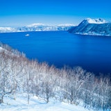
Tracing the grand caldera of volcanoes, forests, and lakes: the Mashu–Kussharo Trail (MKT)
The Mashu–Kussharo Trail (MKT) is a walking route roughly 62 km long that links the first Mashu Lake observation deck to Bihoro Pass.
MKT divides into three sections, so you can either through-hike it over three days or tackle the sections separately across several trips. Enjoy it in whatever style suits you.
https://masyuko.or.jp/enjoy/mkt/...
This text has been automatically translated.
Show original text
Show original text