![[Image1]🚶♀️🏔️〈Hokkaido East Trail〉The Hokkaido East Trail, a long-distance route linking three national par](https://img.cooljapan-videos.com/files/member_posts/image/d4df522846eb92d94de1601b4328628e0246060b.jpg)
![[Image2]🚶♀️🏔️〈Hokkaido East Trail〉The Hokkaido East Trail, a long-distance route linking three national par](https://img.cooljapan-videos.com/files/member_posts/image/3ebf913821e178200061e3d9fcedb9d5baf24a46.jpg)
![[Image3]🚶♀️🏔️〈Hokkaido East Trail〉The Hokkaido East Trail, a long-distance route linking three national par](https://img.cooljapan-videos.com/files/member_posts/image/cf8d17a68ce870ffa5b5d5062d3e10ef91f94070.jpg)
![[Image4]🚶♀️🏔️〈Hokkaido East Trail〉The Hokkaido East Trail, a long-distance route linking three national par](https://img.cooljapan-videos.com/files/member_posts/image/e411fff48d84d52f23f4959cea7babc0928454c4.jpg)
![[Image5]🚶♀️🏔️〈Hokkaido East Trail〉The Hokkaido East Trail, a long-distance route linking three national par](https://img.cooljapan-videos.com/files/member_posts/image/bd46d947c3fc58e37550c4bc4fcf1b31e95646a3.jpg)
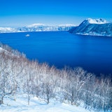
🚶♀️🏔️
〈Hokkaido East Trail〉
The Hokkaido East Trail, a long-distance route linking three national parks and towns, opened in October 2024 and runs roughly 410 km north to south across eastern Hokkaido from Kushiro City to Rausucho.
This trail is highly recommended for the coming season, so here is a brief introduction. For more details, see Teshikaga Navi.
※When undertaking the trail, be sure to complete proper preparations in advance.
Correction)
On the first page, part of the wording has been corrected
https://masyuko.or.jp/enjoy/dototrail/...
This text has been automatically translated.
Show original text
Show original text