-
Article
-
Channel
-
Region
-
Season
-
Tag
Articles
-
 Video article 3:07
Seabirds have taken up residence on a new island born in Japan? Check out the latest rare footage of Nishinoshima Island in Ogasawara Village, Tokyo, which has grown to the size of 60 Tokyo Domes due to active volcanic activity on the ocean floor!
News- 64 plays
- YouTube
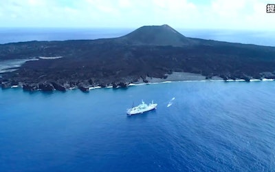
Video introduction of "Nishinoshima" in Ogasawara Village, Tokyo Check out the news video “New footage of research in Nishinoshima. Nishinoshima growing to the size of 60 Tokyo Domes!(西之島調査の最新映像 東京ドーム約60倍に成長中!)” publicized by FNN.jp Prime Online. Nishinoshima is a newborn desert island that was born in the 2013 undersea volcano eruption, swallowing up preexisting islands. In the area around Nishinoshima, which was previously an isolated island far off in the sea, seabirds and fish have settled down and created a new ecosystem. Please enjoy this amazing footage of the new, growing Japanese island. How Big Is Nishinoshima? Source : YouTube screenshot Nishinoshima is a desert island located in the Ogasawara Islands (小笠原諸島, Ogasawarashoto),and is located about 1000 kilometers from Tokyo and about 130 kilometers from Chichijima Island (父島, Chichijima). Currently, as you can see in the video from 2:08, its land mass is about 2.9 square kilometers (1.1 sq. mi.), 1000 times the size of the original island. Nishinoshima, created by a volcano in Japan, is expanding little by little due to cinder from the mouth of the volcano building up and then hardening due to the flow of magma. Nishinoshima's New Ecosystem Source :YouTube screenshot Nishinoshima, the newly formed island in Japan, is made of black rough walls of cooled, hardened lava. The ground surface is covered with andesitic lava flow, creating the landscape of a precipitous cliff. The Geographical Survey Institute (国土地理院, Kokudochiriin) has been visiting the island to research its mantle and magma composition. According to this research, the island has expanded since it was born in 2013, and its ecosystem is changing as well. The masked booby (アオツラカツオドリ, Aotsurakatsuodori), shown from 0:23 in the video, is thought to have inhabited Nishinoshima very recently. As you can see from 1:38, the boobies have been spotted laying eggs inside of the island. A new life, that of a baby bird, is being born on this island. Summary of Nishinoshima, Japan's Newest Island Source :YouTube screenshot On Japan’s seafloor, active volcanic activity still continues and the continent is set to slowly grow bigger. When you see new islands appear and change the size of the continents, it reminds you that the shape of the continents shifts each and every year. Many experts are continuing research in Nishinoshima, so keep an eye out for any new information! Please enjoy this amazing footage of Nishinoshima, an island where very few have set foot. 【Official Website】Nishinoshima|Marine Volcano Database|Japan Coast Guard Marine Information Department https://www1.kaiho.mlit.go.jp/GIJUTSUKOKUSAI/kaiikiDB/kaiyo18-e1.htm -
 Video article 1:49
The Dynamic Eruption of Shinmoedake on Mt. Kirishima. The Invaluable Footage of this Volcanic Eruption in Kagoshima Prefecture Shows the Fury of Nature That Stretches Far Beyond the Human Imagination
Nature- 191 plays
- YouTube
The Eruption of Shinmoedake, Mt. Kirishima Before we begin, please watch the video "The moment of a volcanic eruption! Shinmoedake “Spouting Volcanic Bombs” Kirishima Mountain Range(火山噴火の瞬間!新燃岳「噴出す火山弾」霧島連山)". This is a video of the powerful eruption of Shinmoedake, Mt. Kirishima in Kagoshima Prefecture(鹿児島県,Kagoshimaken). You can feel the fury of nature that stretches far beyond the human imagination by watching the video of the dynamic eruption. We will introduce Shinmoedake, Mt. Kirishima through the video with this article, so be sure to follow along. What Kind of Place Is Shinmoedake? Photo:Kirishima Geopark Kirishima Mountain Range is a group of volcanoes that stretches from Miyazaki Prefecture (宮崎県,Miyazakiken) to Kagoshima Prefecture in Southern Kyushu (南九州,Minami-kyushu). Shinmoedake, which is introduced in the video, is 1,421 meters above sea and is located almost halfway between Karakunidake (韓国岳,Karakunidake), the highest mountain in Mt. Kirishima, and the sacred Mount Takachiho (高千穂峰,Takachihonomine) in the east. The area surrounding the peak of Shinmoedake consists of craters and calderas, which are hollows in the ground created by volcanic activity, and it stretches over Kirishima City, Kagoshima Prefecture, while the area surrounding the ridge line stretches over Kobayashi City (小林市,Kobayashishi), Miyazaki Prefecture. As you can see in the video, volcanic activity still continues actively in Shinmoedake. The History of Volcanic Activity in Shinmoedake Photo:Shinmoedake The history of Shinmoedake’s volcanic activity is thought to stretch back about 150,000 years. Shinmoedake is a volcano that has violent eruptions called "Plinian eruptions," which produce enormous amounts of volcanic products and energy, and it has been responsible for massive disasters such as the Kyoho Eruption and the Bunsei Eruption in the Edo period (1603-1868), as well as the Showa Eruption of 1959. From existing research, we know that the volcanic eruption during the Showa period was caused by an explosion of water vapor, not magma. The Current State of Shinmoedake Source :YouTube screenshot Shinmoedake’s volcanic alert level is currently level 3 out of 5, and the damage from the falling ash is also immense. Mountaineering on the volcano is also restricted, so the effect on tourism is quite large as well. There are also volcanoes other than Shinmoedake in Kyushu such as Sakurajima (桜島,Sakurajima) and volcanic eruption alerts come frequently, so it is important to check the newest information as often as possible. This video is of Shinmoedake, Mt. Kirishima in January 2011. You can see bright red lava bursting out and rocks flying through the sky from 0:15. You can also see lightning called “volcanic thunder” flash across the rising pitch-black ashes from 1:03. Summary of the Video on Shinmoedake's Volcanic Eruption This video of the volcanic eruption that we introduced is barely 2 minutes long, yet it is a powerful piece of footage that conveys the fury of nature. The volcanic alert level of Shinmoedake, Mt. Kirishima is still extremely high and its activities are being observed carefully. If you are ever to travel close to Mt. Kirishima in Kagoshima, be careful and be prepared! 【Tripadvisor】Shinmoedake https://www.tripadvisor.com/Attraction_Review-g1022935-d1384894-Reviews-Mt_Shinmoe-Kirishima_Kagoshima_Prefecture_Kyushu.html -
Video article 3:05
The Omuroyama Yamayaki (burning of Mt. Omuro) in Ito City, Shizuoka Prefecture, is a traditional event that heralds the spring season!
Travel Traditional Culture Nature- 95 plays
- YouTube
Video Introduction of "Omuroyama Yamayaki" in Ito City, Shizuoka Prefecture This video, titled "2018 4K Mt. Omuro Mountain Burning" (2018 4K大室山・山焼き), was uploaded by "ATELIER ROCKY KALEIDOSCOPES GALLERY." The Mt. Omuro Mountain Burning is an exciting event where an entire mountain is engulfed in flames. The Mt. Omuro Mountain Burning, the symbol of Ito, Shizuoka, is not only a popular tourist attraction, but also a traditional winter event that heralds the arrival of spring in Izu. Please take a look at the aerial footage of showing the magnificent Mt. Omuro Mountain Burning via drone. Mt. Omuro and the Popular Anime Movie 'Your Name' Photo:Mt. Omuro, Ito, Shizuoka Mt.Omuro is a dormant volcano sitting at an elevation of 580m in Ito, Shizuoka, in Japan's Tokai region. At the top of the mountain is a 300-meter-wide, mortar-shaped crater left over from an eruption 4,000 years ago. Because of its unique shape, the mountain attracted a lot of attention among fans of the move Your Name, who speculated that it might have been the model for the mountain in Itomori, where Taki and Mitsuba, the main characters in the movie, met. Mt. Omuro Sengen Shrine is located halfway up the crater and is dedicated to the god of easy childbirth and matchmaking, and enshrines the Five Dhyani Buddhas. The entirety of Mt. Omuro is known as a power spot. Mt. Omuro is a popular tourist spot for climbers. For environmental conservation, climbers use the Mt. Omuro lift to climb to the top of the mountain. There is also a popular tour where you can walk around the mortar-shaped mountaintop while enjoying the spectacular view. You can also enjoy archery and delicious food on the summit as well, and there are also steamed buns with cherry blossom leaves being sold there, as well as a variety of other local specialties and souvenirs. Mt. Omuro is not only famous for its mountain burning, but is also known for its cherry blossoms in spring and foliage in autumn, so you can enjoy the beauty of Japan's four seasons year-round. Why Is Mt. Omuro Burned? The History of the Fiery Tradition Photo:Mt. Omuro mountain burning, Ito, Shizuoka The origin of the Mt. Omuro Mountain Burning dates back approximately 700 years. Initially, it was done for the purpose of improving the growth of high-quality thatch, which was essential for people's lives, and for the purpose of pest control. There are 2 types of thatch: Kogaya and Tawaragaya. Kogaya was used for thatched roofs, as fertilizer for growing wheat, and as feed for cows and horses. It is said that Tawaragaya was used to make charcoal bales for packing charcoal, as charcoal production thrived on Mt. Omuro. The Mt. Omuro Mountain Burning has remained as a traditional event throughout its history, thanks to the efforts of the local people. In order to preserve the tradition of the mountain burning as a sightseeing event, as well as to pass on the skills of mountain burning, the local people formed the Mt. Omuro Mountain Burning Preservation Society, which has continued to protect the event to this day while paying close attention to safety. Mt. Omuro Mountain Burning Festival 2023 Schedule Photo:Mt. Omuro mountain burning, Ito, Shizuoka Mt. Omuro Mountain Burning will be held on Sunday, February 12, 2023. Mt. Omuro Mountain Burning is held on the second Sunday in February every year, and will be held with the same schedule this year. However, the Mt. Omuro Mountain Burning may be postponed due to weather conditions on the day of the event for safety and other concerns. For safety reasons, the event is postponed on windy days as well, so please check the official Ito Tourist Association website before visiting for sightseeing purposes. The 2022 festival was postponed until March 13. The fires on Mt. Omuro are lit from 9:30 a.m. at the bowl and from 12:00 p.m. for the rest of the mountain. Since it's expected to be crowded on the day of the event, it's recommended that you get there early. Also, if you want to participate in the lighting of the whole mountain burning with torches, participants are chosen on a first come, first served basis every year. However, no dates, numbers or prices have been announced at this time. If you would like to participate, please check the information in advance. The Best Spots to Watch the Mt. Omuro Mountain Burning! Photo:The Mt. Omuro lift, Ito, Shizuoka Mt. Omuro Mountain Burning is a grand-scale event in which the entire mountain is engulfed in fire, so you can pretty much watch it from anywhere in the area. If you want to experience the flames up close, we recommend going near the Mt. Omuro lift. This is also the place where torches are lit for the all-mountain burning, so you can directly feel the heat and hot air from the burning mountain, making it a powerful spot. If you want to enjoy a panoramic view of the Mt. Omuro Mountain Burning, we recommend Sakura no Sato. The parking lot is nearby, and it's only moderately crowded, so it's suitable for those who want to see the whole mountain. Also, if you have children with you, they may get bored while waiting for the mountain burning. In such a case, we recommend visiting Izu Shaboten Zoo. In the large park, you can enjoy not only the panoramic view of the mountain burning, but also 1,500 kinds of cacti, feeding animals, and petting capybaras. Your kids are sure to have a great time here! Summary of the Mt. Omuro Mountain Burning Mt. Omuro is a symbol of Izu, Ito, and Izu Kogen. From the top of the mountain, you can enjoy a superb view of Mt. Fuji that's great for taking photos. Mt. Omuro Mountain Burning is a spring tradition known as one of the 8 Views of Ito. Ito Onsen is also nearby, so consider stopping by after watching the Mt. Omuro Mountain Burning. We hope you enjoy this traditional event on the Izu Peninsula! 【Official Website】Mt. Omuro 【TripAdvisor】Mt. Omuro -
Video article 8:19
Enjoy the autumn leaves of "Mt. Nasu (Chausu-dake)" in Nasu-gun, Tochigi Prefecture in 4K video! What are the autumn foliage hiking course and the best view points?
Nature Travel- 82 plays
- YouTube
Autumn color video introduction of "Mt. Nasu (Chausu-dake)" in Nikko National Park located in Nasu-gun, Tochigi Prefecture, Japan. Photo:Autumn on Mt. Nasu (Mt. Chausu), Tochigi Prefecture This video, titled "[4K]【Nikko National Park】 Autumn leaves of Mt. Nasu Kanto No. 1 autumn leaves spot 2020," was uploaded by "Superb view of Japan." Mt. Nasu, which boasts some of the best autumn leaves in the Kanto region, is located in Nikko National Park in Tochigi Prefecture. What makes Mt. Nasu so great in autumn is that visitors can enjoy hiking while viewing the beautiful autumn leaves. The combination of the majestic Mt. Nasu and the blazing red autumn leaves, as shown in the video, will make you want to see it in person! Be sure to check out the incredibly scenery in the video in 4K! When to See Autumn Leaves on Mt. Nasu Photo:Mt. Nasu (Mt. Chausu), Tochigi Prefecture Mt. Nasu, the main peak of the Nasu Mountain Range, a volcanic group centering on the five peaks of Nasu, is also called Mt. Chausu, and has been selected as one of the 100 Famous Japanese Mountains. Located in the northwestern part of Nasu, Tochigi, in Japan's Kanto region, Mt. Nasu is 1,915 meters (~6,283 ft.) above sea level. Together with Mt. Asahi to the north, it's a great place to enjoy the autumn colors of mountain maples and azaleas in the fall. Because Mt. Nasu is an active volcano even today, you can smell sulfur in the air around it. The best time to view the autumn leaves is usually from late September to early October, and since there is a ropeway, both beginners and advanced hikers can enjoy them. The area is crowded with hikers who come to see the autumn colors every year. Highlights & Where to See the Autumn Leaves on Mt. Nasu Photo:Autumn leaves at Ubagadaira, Mt. Nasu (Mt. Chausu), Tochigi Prefecture The highlight of the autumn leaves on Mt. Nasu is the collaboration between the active volcano, Mt Nasu, and the fiery red autumn leaves that can be seen all the way up to the top of the mountain. [Video] 1:33 - Beautiful Autumn Leaves on Mt. Nasu While the view from the top of the mountain is, of course, spectacular, the panoramic view of the town below and the colorful autumn leaves will take your breath away. There is also a well-maintained hiking trail at the top of the mountain, so you can make a round trip around the caldera. If you go when the leaves are changing colors, the spectacular view from Ubagadaira is something you don't want to miss. The volcanic gasses and autumn leaves atop the majestic Mt. Nasu are sure to leave a lasting impression! Don't forget to bring a camera, because this is an excellent spot for taking photos. [Video] 5:57 - Ubagadaira at the Foot of Mt. Nasu Hiking Trails and What to Wear When Hiking Mt. Nasu in Autumn Photo:The Mt. Nasu Ropeway, Tochigi Prefecture Mt. Nasu is a great mountain for both beginners and experienced hikers alike. There are several hiking trails on Mt. Nasu with varying levels of difficulty, but the course using a ropeway is recommended for beginners. For those interested in hiking Mt. Nasu but feel that they are not ready for the challenge of a full-scale hiking adventure, we recommend using the ropeway. It takes about 50 minutes to reach the top of Mt. Nasu from Nasu Ropeway Station. This is a hiking course where you can casually enjoy climbing the mountain while viewing the autumn leaves. For those looking to hike Mt. Nasu, here are some tips on what to wear and what temperatures to expect when hiking during autumn. From late September to late October, the best time to view the autumn leaves, the temperature is usually around 10°C (50°F). Mornings and evenings are cold and there can be strong winds when you reach the summit, so be sure to wear clothing that is easy to put on and take off, as well as layers of clothing to regulate your body temperature. For shoes, wear hiking boots or other suitable footwear for hiking, and don't forget rain gear as the weather in the mountains can be unpredictable. Climbing Mt. Nasu for Beginners – Ropeway Fees, How to Get There, Etc. Photo:Mt. Nasu and the Mt. Nasu Ropeway, Tochigi Prefecture When accessing the trailhead by car, there are three parking lots. Nasu Ropeway parking lot: 175 cars Nasu Toge no Chaya Parking Lot 1 & 2: 167 spaces Daimaru Parking Lot: 160 spaces The round-trip ropeway fee is 1,800 yen for adults (junior high school students and older) and 900 yen for children (Ages 3 to elementary school students). The ropeway recommended for those who are just looking to see the autumn leaves, as they can be seen from the ropeway when they're in season. It takes about 4 minutes to reach the station at the top from Nasu Ropeway Sanroku Station. You'll reach the 9th station of Mt. Nasu in no time. Things To Do Near Mt. Nasu Photo:Tsutsuji Suspension Bridge, Nasu Kogen, Tochigi Prefecture Here are some places of interest that we recommend checking out when visiting Mt. Nasu. Nasu Onsen Mt. Nasu is located right next to Nasu Onsen, and in the nearby onsen town, visitors can enjoy a variety of different hot springs to relax after a day of sightseeing or hiking. The oldest hot spring at Nasu Onsen is Shika no Yu, meaning "Deer Hot Spring." This hot spring is 1,300 years old and is the origin of Nasu Onsen. Its name comes from a legend that the local villagers saw an injured deer limping around, but after falling into the hot spring it miraculously recovered. Tsutsuji Suspension Bridge Tsutsuji Suspension Bridge is a beautiful bridge that stretches across a low valley. In the fall, the surrounding trees change to beautiful shades of yellow and orange and delight the eyes of visitors. The bridge itself is aesthetically pleasing as well, so be sure to take a photo with it when visiting. Besides the two places mentioned above, there are a number of other attractions in the area, including the famous "Killing Stone" located across the bridge. According to legends, the stone was said to hold the spirit of a nine-tailed fox demon that turned into such after being vanquished after attempting to assassinate Emperor Toba (1103-1156). In recent years, the stone suddenly split in half, and can still be seen by visitors. Also in the area are numerous waterfalls, museums, and many more exciting things to see and do. There are also some lovely azalea fields nearby that can be seen blooming in the spring. During autumn, they're known for their wonderful foliage. Summary of Autumn Leaves on Mt. Nasu Photo:Autumn leaves on Mt. Nasu (Mt. Chausu), Tochigi Prefecture The beautiful autumn leaves against the white smoke and black surface of the mountain make Mt. Nasu a sight that should be on anyone's bucket list. Mt. Nasu is expected to see heavy traffic during the autumn months. When visiting, it's recommended that you check not only the weather forecast, but also how far along the leaves are and how crowded the parking lots are with live cameras. After climbing the mountain, you can stop by an onsen (hot spring) to relax after a long day of hiking. Hot springs can be enjoyed by visitors on even one-day trips at Holiday Village Nasu. In addition to Mt. Nasu, Nikko National Park is home to a variety of scenic locations. If you're visiting Tochigi, be sure to take a moment to appreciate its natural beauty as well! [TripAdvisor] Mt. Nasu