-
Article
-
Channel
-
Region
-
Season
-
Tag
Articles
-
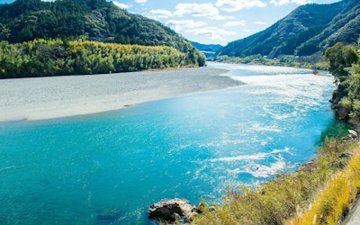 Video article 3:03
The Niyodo River in Shikoku Is Famous for Having the Clearest Waters of All Rivers in Japan! Enjoy the Mystical World of the Crystal Clear Waters Coined "Niyodo Blue"!
Nature- 145 plays
- YouTube
Niyodo River: The Best Water Quality in Japan! This video, titled "[4K] 仁淀ブルー:奇跡の清流 仁淀川(高知県 仁淀川水系)Niyodo River,the best water quality river in Japan.," was created by "AQUA Geo Graphic." When asked about famous rivers in the Shikoku region, most people picture the Shimanto River (四万十川, shimantogawa), but did you know there is an even prettier river in the area? I'm of course referring to the Niyodo River. As the third largest river in Shikoku, after the Shimanto River and Yoshino River (吉野川, yoshinogawa), it ranks number one year after year as the river with the best water quality in Japan. As you can see in the video, the crystal clear water of the Niyodo River is absolutely stunning and has been given the name "Niyodo Blue" after its mystical blue color. In the video, you can enjoy viewing the river from both above and below the surface of the water! Serpent Sanctuaries and Instagrammable Spots Near the Niyodo River Photo:Niko Deep, Kochi Prefecture Mt. Ishizuchi's (石鎚山, ishizuchisan) Omogo River in Ehime Prefecture (愛媛県, ehimeken) is the main water source for the Niyodo River and the streams that run through the valleys of Kochi Prefecture (高知県, kouchiken). Niyodo River is 124 kilometers long and has a surface area of 1,560 square kilometers. The river runs through mainly mountainous regions and the combination of both the beautiful natural surroundings and stunning blue color of the river makes the area very picturesque. From 1:50 in the video, you can see the basin of "Nikobuchi" (にこ淵), which is thought to be the home of the legendary eight-headed serpent Yamata no Orochi. On a sunny day during the hours of 11 am and 3 pm, the light shines directly into the pool and the blue color of the river is even more prominent. We highly recommend visiting Nakatsu Gorge (中津渓谷, nakatsukeikoku) and Yasui Gorge (安居渓谷, yasuikeikoku) during the fall to see the beautiful scenery. There are many beautiful spots along Nakatsu Gorge, such as Uryu Falls (雨竜の滝, uryuunotaki), Momiji Falls (もみじだき) and Ryugubuchi (竜宮淵). The special rocks called "Ishibashira" (石柱) are another great sightseeing spot. The pool of water known as "Suishobuchi" (水晶淵) along Yasui Gorge changes color from blue to green depending on the season and time of day. The contrasting colors of the fall foliage and the river attracts many visitors and the area has become a very popular tourist destination. In the second half of the video, from 2:09, you can see some of the low-water crossings found along Niyodo River. A distinguishing feature of these types of bridges is that they have no sides or guard rails, which allows them to blend easily into the surrounding nature creating a beautiful landscape. The Niyodo River Is Popular Among Both Locals and Tourists! Photo:Niyodo River, Kochi Prefecture In recent years the number of tourists visiting the Niyodo River has increased dramatically, but the river is still just as popular among the locals. The Niyodo River area has a population of approximately 110,000. In the middle reaches of the river, there's the multi-purpose Odo Dam (大渡ダム) and facilities for flood control and power supply development, which support the lives of people living in harmony with the Niyodo River. There are also several campsites in the area for those who'd like to spend the night in the beautiful outdoors. There are many fun activities to take part in, such as canoeing and rafting or you can simply go for a swim. There is also a stone skipping competition held here each year. The locals can often be seen playing in the river. In 2002, the Niyodo River was the most visited river in Japan. Not only is it the most beautiful river in Japan, it's also the most loved river by its locals. Summary of the Niyodo River Photo:The Niyodo River and a low-water crossing, Kochi Prefecture The mystical blue water of the Niyodo River captivates all who look upon it. The majority of the river is surrounded by mountains making it fairly difficult to access via public transportation. We recommend renting a car or taking a trip to the river by bike! There is a roadside station near the river with hot spring facilities where you can also spend the night, a perfect place to relax after a long day of sightseeing. For those who don't have a valid driver's license in Japan but still wish to visit the Niyodo River, please check out the Niyodo River Tourist Association (仁淀川観光協会, niyodogawa kankou kyoukai) website for more information on how to access the river via public transport (※Unfortunately the website is only in Japanese). Some of the roads from the car park to the spots introduced in the video can be slippery so please be careful when walking. If you still haven't yet, be sure to enjoy the mystical world of the beautiful, blue Niyodo River in the video. 【Tripadvisor】Niyodo River https://www.tripadvisor.com/Attraction_Review-g298233-d10383500-Reviews-Niyodo_River-Kochi_Prefecture_Shikoku.html -
 Video article 3:27
The World of the Ghibli Film "Castle in the Sky" Has Spread To Aso, Kumamoto Prefecture! With Its Rich, Unexplored Landscape and Spectacular Scenery, Aso Is a Popular Spot for Drives!
Nature- 129 plays
- YouTube
Introducing Aso in Kumamoto Prefecture! This video, titled “Best Views of Japan – Unexplored|Searching for Laputa in Aso, Only To Find That Aso Is Laputa!” (日本一の絶景 秘境 ラピュタの道を阿蘇に探しに行ったら、阿蘇の全てがラピュタだった), was released by “Drone RangerMiura.” It introduces the beautiful summer scenery of Aso, Kumamoto Prefecture, in Japan’s Kyushu region. The scenery of Aso Gogaku (阿蘇五岳, The Five Peaks of Mt. Aso), shot via drone, looks just like the world of the Studio Ghibli movie "Laputa: Castle in the Sky." In the Aso area, there are sightseeing spots called "Laputa Road" (ラピュタの道) and "Laputa Modoki" (ラピュタもどき), which have been attracting attention from people who enjoy going on casual drives to enjoy scenic locations. A Look at Laputa Road, Shown in the Video Photo:Aso, Kumamoto Prefecture The official name of “Laputa Road” is “Aso City Road Kario Main Line” (阿蘇市道狩尾幹線). From Prefectural Road 149 to Prefectural Road 339 (a.k.a. Milk Road), which runs over the outer rim of the mountain, a mysterious phenomenon creates a sea of clouds, allowing for breathtaking views. At 0:33 in the video, cows and horses are shown, and at 1:05, a beautiful waterfall can be seen. In the Aso area, you can go for a walk and discover the unexplored natural scenery, as well as enjoy activities, such as horseback riding and stargazing. Popular Spots in the Aso Area Introduced in the Video Photo:Daikanbo Lookout on Mt. Aso, Kumamoto Prefecture There are many spots in the Aso area where you can enjoy superb scenery, such as the Laputa Road Observatory and the Daikanbo Lookout (大観峰展望台) on Daikanbo, one of the peaks of the Northern Outer Rim of Mt. Aso. If you visit the Aso area to view the scenery, be sure to stop by the observatory! There are also many park facilities, such as the Oku-Aso Fruit Garden (奥あそフルーツガーデン), Rakunoh Mother's Aso Milk Ranch (阿蘇ミルク牧場), and Aso Farmland (阿蘇ファームランド). Be sure to check out Aso Shrine (阿蘇神社) as well! Points To Note When Sightseeing in the Aso Area Photo:The Nanatsugama Caves, Kumamoto Prefecture In the Aso area, there are many places of interest, such as the Nanatsugama Caves in Saga Prefecture's Karatsu, which is designated as a national natural monument, and Kusasenrigahama. However, due to risk of eruption, the area around the crater has been placed on alert and entry is now restricted. The 2016 Kumamoto earthquakes also caused some road closures in the Aso area. When visiting Aso, be sure to pay attention to observation information and alerts/warnings. Summary of the Aso Area Photo:Mt. Aso, Kumamoto Prefecture Aso is one of the most popular tourist spots in the Kyushu area thanks to the natural beauty of the mountains and sea. If you're looking to experience what it's like to be in the world of "Castle in the Sky," then you should definitely drop by Aso for a visit! 【Tripadvisor】Mt. Aso https://www.tripadvisor.com/ShowUserReviews-g298212-d320703-r710938456-Mt_Aso-Kumamoto_Prefecture_Kyushu.html -
Video article 3:35
Shirasaki Coast in Wakayama Prefecture, Called the "Aegean Sea of Japan," Is Just Like a Painting! Introducing the Charms and Activities of Shirasaki Coast!
Nature- 114 plays
- YouTube
Introducing Shirasaki Coast in Wakayama Prefecture! This video, titled "Shirasaki Coast (Wakayama) A Beautiful Scenic Location Called the Aegean Sea of Japan" (白崎海岸(和歌山)日本のエーゲ海と称される絶景スポット), was released by "K Japan Traveler." Shirasaki Coast in Wakayama prefecture, which has a magnificent view on Instagram, was selected as one of the Top 100 Beaches of Japan, and in 2009, it was also selected as one of the Top 100 Landscapes of the Yomiuri Shimbun. Many tourists visit the beach throughout the year, where the contrast between the blue of the sea and sky and the pure white of limestone and sandy beaches is attractive. The History and Highlights of Shirasaki Coast Photo:Shirasaki Coast, Wakayama Prefecture Shirasaki Coast is the sea of the Shirasaki Coast Prefectural Natural Park in Yura, Hidaka District, Wakayama Prefecture, and, as you can see at 0:33 in the video, is characterized by the white limestone surrounding it. Geologically, limestone is said to have come from the Permian Period in the latter half of the Paleozoic Era, more than 200 million years ago. From spring to summer, a large group of black-tailed gulls fly to Shirasaki Coast in Wakayama prefecture, which is rich in nature, as you can see from 3:03 in the video. The marine park is also known for its daffodils. Things To Do at Shirasaki Coast in Wakayama Prefecture Photo:Shirasaki Coast, Wakayama Prefecture We recommend enjoying swimming, fishing, and Shirasaki cruise activities around Shirasaki Coast in Wakayama prefecture. There are also diving spots and diving pools nearby. From Shirasaki Manyo Park, we recommend enjoying the view of the strange rocks "Tatego" and "Oobae," which are the symbols of Shirasaki Coast. Also, stop by Koukokuji Temple, the Shellfish Exhibition Hall, the Park Center, Shirasaki Marine Park Observatory, and Totsui Limestone Cave. Dining and Lodging at Shirasaki Coast Photo:The Starry Skies of Shirasaki Marine Park, Wakayama Prefecture Around Shirasaki Coast, there are many restaurants and cafes where you can eat seafood dishes such as Shirasu-don on a low budget as well as the famous Shirasaki curry. In addition, there's Roadside Station Shirasaki Ocean Park where you can buy souvenirs, and hotels that are ideal for accommodation, so plan your trip carefully! Summary of Wakayama Prefecture's Shirasaki Coast As you can see in the video, the charm of Shirasaki Coast is that you can enjoy the spectacular blue and white scenery. When the sun sets, you can see a soothing view that you won't find during the day. Be sure to check out the business information and regular holidays for the Shirasaki Marine Park campsite and the surrounding facilities before visiting for sightseeing. ◆ Introduction to Shirasaki Coast ◆ 【Address】Take a bus from JR Kii-Yura Station and get off at Shirasaki Nishi, and walk 1.5 km. 【Parking】Free Parking Available 【Tripadvisor】Shirasaki Marine Park https://www.tripadvisor.com/Attraction_Review-g1121347-d1385202-Reviews-Shirasaki_Ocean_Park-Yura_cho_Hidaka_gun_Wakayama_Prefecture_Kinki.html -
Video article 1:56
Suishohama Seaside Resort in Fukui Prefecture Is Regarded as One of the Top Beaches in Japan! It's Hard To Believe This Cobalt Blue, Crystal Clear Water Is in Fact the Sea of Japan!
Nature- 146 plays
- YouTube
Suishohama Seaside Resort in Mihama This video, titled "Suishohama" was created by "Wakasa Mihama Tourist Association" (一般社団法人若狭美浜観光協会). It contains footage of the beautiful scenery of Suishohama Seaside Resort taken via drone photography. The seaside resort was named Suishohama (水晶, "suisho," means "crystal" in Japanese) after the glistening white sand the beach is famous for. Suishohama was selected as one of the top 88 beaches and top 55 swimming spots in Japan. In this article, we'll introduce the hidden gem that is the Suishohama Seaside Resort. You can take a look at the sandy white beach that stretches as far as the eye can see and the sea floor covered with crystal clear water via aerial photography. It's hard to believe such beautiful scenery can be found near the Sea of Japan! What Kind of Tourist Spot Is Suishohama Seaside Resort? Photo:Suisuihama Beach, Fukui Prefecture Suishohama Seaside Resort, which is located along the west side of Tsuruga peninsula (敦賀半島) in Fukui prefecture, is a picturesque location looking out onto Wakasa Bay (若狭湾) with a great view of Tsunegami peninsula (常神半島) in the distance. The crystal clear, cobalt waters of Suishohama Seaside Resort are also famous for surfing, swimming, and other marine sports, with people visiting early in the morning to enjoy them. Suishohama Seaside Resort is also known as "Sunset Beach" and is a popular spot for couples who come to enjoy star-gazing together. The beach takes on various beautiful forms throughout the day. You are guaranteed to leave with some great photos to share on Instagram! You can check out the sunset at Suishohama Seaside Resort from 1:42 in the video. Suishohama Seaside Resort Tourist Information Photo:Suisuihama Beach parking lot in Fukui Prefecture Suishohama Seaside Resort is easily accessible, taking approximately 15 minutes to reach by car from Wakasa Mihama Interchange (若狭美浜IC) on the Maizuru Wakasa Expressway (舞鶴若狭自動車道). Parking is available next to the beach. For those traveling by train, take the bus headed for "Shiraki" (白木) from JR Tsuruga station (JR 敦賀駅) and get off at "Suishohama." The summer swimming season is from mid-July to late August and is often very crowded with tourists at this time. There are guesthouses, campsites, and barbecue spots in the area as well. If you're planning on staying the night, consider trying some of the delicious local seafood. Near Tsuruga station is the fish market "Nihonkai Sakana Machi" (日本海さかな町) where you can enjoy shopping and also grab a bite to eat! Also, along Tsuruga peninsula you'll find Daiyahama beach (ダイヤ浜) and Takenami Seaside Resort (竹波海水浴場) located adjacent to one another, meaning you can easily spend the whole day enjoying the area without having to travel long distances. Summary of Suishohama Seaside Resort Photo:Suisuihama Beach, Fukui Prefecture The video introduces the beautiful scenery of Suishohama Seaside Resort. Enjoy the sandy white beaches, cobalt blue waters, and large rock formations from the sky. In this article, we introduced tourist information for Suishohama Seaside Resort. We hope after watching the video you're tempted to take a trip to Fukui prefecture! Mihama is easily accessible from Tokyo and the Kansai region of Japan. You can take a look at Suishohama Seaside Resort online 24 hours a day via live camera as well. 【Official Website】Suishohama Seaside Resort|Tourist Destination|Fukui Prefecture Tourist Information https://www.fuku-e.com/lang/english/ 【Tripadvisor】Suishohama Seaside Resort https://www.tripadvisor.com/ShowUserReviews-g1121171-d1423763-r557541585-Takenami_Beach-Mihama_cho_Mikata_gun_Fukui_Prefecture_Hokuriku_Chubu.html -
Video article 5:17
Osaka's Iconic Umeda Sky Building Gets a Renovation for Its 25th Birthday! Experience Something Out of the Ordinary at the Kuchu Teien Observatory Where You Can See the Whole City of Osaka!
Art & Architecture- 24 plays
- YouTube
This video, titled "Renovation of the Umeda Sky Building to Celebrate Its 25th Anniversary" (梅田スカイビル開業25周年リニューアル), was released by "SankeiNews." The Umeda Sky Building is a landmark building in the Umeda area of Osaka. It is a super skyscraper with 40 floors above ground, 2 floors below, and stands 173 meters tall. The observatory was renovated in 2018 to coincide with the 25th anniversary of the building since it first opened in 1993. The Kuchu Teien Observatory at the top of the Umeda Sky Building offers a stunning view of the metropolis of Osaka. The observation deck is located on the rooftop, so you can enjoy the scenery while feeling the breeze. The exhilarating view shown in the video is worth checking out, but it can be a bit scary if you're not fond of heights! -
Video article 3:09
A Fantastic Spot Where You Can Have Kobe's Million Dollar Night View All To Yourself! The Sparkling Night View From the Observatory on Hyogo's Mt. Maya Will Leave You Speechless!
Travel- 57 plays
- YouTube
The Night View of Kikuseidai This video, titled "Kobe's 10 Million Dollar Night View|Time Lapse|Kikuseidai|Mt. Maya|Timelapse|One of Japan's Three Great Night Views" (神戸1000万ドル夜景 タイムラプス 掬星台 摩耶山 timelapse 日本三大夜景), was released by "STAR streamer YOSUKE." It introduces a superb view from the view point "Kikuseidai" in Kobe, Hyogo. The night view from Kikuseidai in Kobe, located in Japan's Kansai region, along with Mt. Hakodate in Hakodate City, Hokkaido, and Mt. Inasa in Nagasaki City, Nagasaki Prefecture, is one of the three major night views in Japan. More About Kikuseidai Photo:Glittering path at Kikuseidai・Kobe, Hyogo Prefecture Kikuseidai, introduced in the video, is a view point located near the summit of Mt. Maya in Kobe, Hyogo Prefecture. Kikuseidai is located at an altitude of 700m and there are attractions such as the Maya Nature Observation Garden, Hôtel de Maya, Mayasan Tenjoji Temple, and Lake Hodaka. In the promenade "Kirakira Komichi" at Kikuseidai, phosphorescent stones that can be recharged with ultraviolet rays from natural light and emit light, creating a fantastical atmosphere reminiscent of the Milky Way. There is also a restaurant on the mountain, so be sure to stop by for a bite to eat of you're hungry. Access to Kikuseidai Photo:Mt. Maya nightview・Kobe, Hyogo Prefecture Using the Maya Viewline is a convenient way to reach Kikuseidai. The ride from Maya Cable Station to Rainbow Station (虹の駅, Niji no Eki) takes about 5 minutes, and from there you transfer to the Maya Ropeway to reach Maya View Terrace 702, the "station of the stars." Kikuseidai is open 24 hours a day and is free of charge, so some people go out to see the sunrise as well as the night view. There's a parking lot on Mt. Maya as well, but be careful as the roads can get quite congested. Also, the road to Kikuseidai is closed to vehicles after a certain point, so you'll have to walk. Recommended Destinations in Kobe Photo:Night view of Kikuseidai・Kobe, Hyogo Prefecture Kobe is close to Kansai International Airport, and you can easily go sightseeing around the area via train or bus, making it a popular destination. In Kobe, you'll want to stop by not only Mt. Maya, where Kikuseidai is located, but also the Mt. Rokko Observatory and Rokko Island, where Emperor Hirohito visited. In addition, Sannomiya's Port Island is great for both sightseeing and shopping. You can see the beautiful night view of Port Island from 1:17 in the video. If you purchase a "Rokko / Maya 1-day ticket" at the "Kobe Information Center" you can enjoy sightseeing in Kobe even more. Summary of Kikuseidai in Kobe, Hyogo Prefecture Photo:Night view of Kikuseidai・Kobe, Hyogo Prefecture As the name suggests, you can enjoy the spectacular view at Kikuseidai, as if you were scooping the stars into your own hands (掬星台, lit. "star scooping pedastal"). The night view of Kikuseidai, which overlooks the city of Kobe when facing Osaka, is also called a "10 million dollar night view." Head over to Kobe to enjoy one of Japan's many beautiful night views! 【Tripadvisor】Mt. Maya https://www.tripadvisor.com/ShowUserReviews-g298562-d1384609-r500562432-Mt_Maya-Kobe_Hyogo_Prefecture_Kinki.html -
Text only
Hokkaido in COOL JAPAN VIDEOS Photo Contests: From Popular Sightseeing Spots to Exotic Animals, Discover the Beauty of Japan's Northernmost Prefecture!
Travel Nature- 324 views
capture the grandeur of Hokkaido, Japan's northernmost prefecture. We'll introduce photos that capture popular sightseeing spots, the unique wildlife of Hokkaido, and more. We hope this will help you get an idea of what Hokkaido is all about! COOL JAPAN VIDEOS is a social, video curation site that introduces the charms of Japan to people around the world who are interested in Japan. Our photo contests allow you to participate and even win with photos taken via your smartphone! Stick around to learn more! ■Table of Contents - Hokkaido in Past Photo Contests Shirogane Blue Pond Hill of the Buddha Lake Nukabira Daisetsuzan National Park Abashiri Prison Museum Flowerland Kamifurano Lake Shikotsu Ice Festival The Ezo Red Fox of Hokkaido Mt. Asahi Notsuke Peninsula - Features of COOL JAPAN VIDEOS Photo Contests - Current Photo Contest - Summary of Hokkaido in COOL JAPAN VIDEOS Photo Contests Hokkaido in Past Photo Contests We have picked out some amazing photos of Hokkaido from among the many wonderful entries that convey the charms of Japan. We'll also introduce some popular photo spots as well! COOLJAPANVIDEOS Photographer: 林 優 Location: Shirogane Blue Pond (Hokkaido) Sightseeing at Shirogane Blue Pond Shirogane Blue Pond is a popular sightseeing spot where the surface of the water appears various shades of blue during different seasons, at different times of the day, and in different weather conditions. The surface of the water appears blue when light reflects off the aluminum and sulfur in the water flowing into the pond from the Biei River. The blue water and withered larch trees create a fantastic scene. At night in fall and winter, the area is lit up and visitors can enjoy a very different scenery from that during the daytime. A Video Article About Shirogane Blue Pond in Biei, Hokkaido Video article 2:10 This Blue Pond in Biei, Hokkaido Is a Natural Miracle Created by Nature. The Beautiful Scenery of This Popular Sightseeing Spot Fascinates All Who See It! YouTube COOLJAPANVIDEOS Photographer: umestagram Location: Hill of the Buddha (Hokkaido) Highlights of the Hill of the Buddha, a Popular Tourist Attraction in Sapporo, Hokkaido From the outside of the Hill of the Buddha, only the head of the Great Buddha can be seen poking out from the top of the lavender-covered hill. Designed by world-renowned architect Tadao Ando, the Daibutsuden (Great Buddha Hall) was built so that a concrete approach leads to the basement of the lavender hill. Looking up through the dimly lit space, visitors can see the Great Buddha surrounded by natural light filtering in through the open ceiling. A Video Article About the Hill of the Buddha in Sapporo, Hokkaido Video article 5:58 Hill of the Buddha - A New Attraction in Sapporo, Hokkaido Designed by a World-Famous Architect. Come Check Out the Buddha as He Pokes His Head Out From a Hill Surrounded by Lavenders! YouTube COOLJAPANVIDEOS Photographer: 三浦奈津美 Location: Lake Nukabira (Kato, Hokkaido) Highlights of Lake Nukabira, a Popular Tourist Attraction in Kato, Hokkaido Lake Nukabira is a man-made lake surrounded by dense virgin forests. At the bottom of the lake is a large human-shaped rock called 'Nukabira.' Taushubetsu Bridge on the east bank of the dam is a concrete arch bridge of the former Japan National Railways' Shihoro Line. It is also called the "phantom bridge" because it appears in winter when the water level is low and sinks to the bottom of the lake and disappears when the water level increases. A Video Article About Lake Nukabira in Kato, Hokkaido Video article 2:40 Discover the Amazing Ice Bubbles at Lake Nukabira! Sightseeing Information for the Fantastical Lake in Hokkaido, Japan! YouTube COOLJAPANVIDEOS Photographer: 古谷久樹 Location: Daisetsuzan National Park (Hokkaido) The Cute Northern Pika of Japan The northern pika is found only in some high-altitude areas of Hokkaido. It can fit in the palm of your hand, is 10 to 20 centimeters long, and weighs 60 to 160 grams. Its ears are round and small, and it's characterized by its frequent squeaking. In 2012, it was listed as a near-threatened species on the Red List of endangered species by the Ministry of the Environment. A Video Article About the Northern Pika Video article 3:01 The Northern Pika of Japan: Learn About the Cute Critter Known as the "God of Rocky Lands" and Found in the Outdoors of Hokkaido. Also See Its Characteristic High-Pitched Cry! YouTube COOLJAPANVIDEOS Photographer: HAYATO/日本の風景写真・絶景スポット Location: Abashiri Prison Museum (Abashiri, Hokkaido) Highlights of the Abashiri Prison Museum, a Popular Sightseeing Attraction in Abashiri, Hokkaido The Abashiri Prison Museum is an open-air history museum that preserves and exhibits the former buildings of Abashiri Prison. The wooden prison buildings that were used during the Meiji Era (1868-1912) have been relocated and reconstructed on a vast site. Eight of the buildings have been designated as Important Cultural Properties of Japan. There are also six registered Tangible Cultural Properties at the museum, including a building made of bricks made in the prison. Visitors can learn about the history of Abashiri Prison, which was instrumental in the development of Hokkaido, from the many exhibits. A Video Article About Tourist Attractions in Hokkaido Video article 3:30 Hokkaido - Endlessly Sweeping Horizons and Magnificent Scenery! Set off on a Trip to Hokkaido's Scenic Locations to Enjoy Spectacular Views of Japan's Natural Landscape! YouTube COOLJAPANVIDEOS Photographer: 長野恵莉佳 Location: Flowerland Kamifurano Highlights of Flowerland Kamifurano, a Popular Tourist Attraction in Kamifurano, Hokkaido Flowerland Kamifurano is a vast flower garden where colorful flowers bloom from June to the end of September. It's a popular tourist attraction with magnificent views of the Tokachi Mountain range and Mt. Asahi. Admission is free, and visitors can ride a tractor bus that circles the 100,000-square-meter flower garden and enjoy the fresh Hokkaido breeze and the fragrance of the flowers in a relaxing atmosphere. A Video Article About Sightseeing in Biei and Furano, Hokkaido Video article 3:18 Outstanding Views of Flowers and Nature in Biei and Furano, Hokkaido. The Scenic View of Lavenders and Poppies, Together With the Natural Scenery of the Surrounding Area, Will Make Your Trip Unforgettable! YouTube COOLJAPANVIDEOS Photographer: koichi hakuchuu Location: Lake Shikotsu Ice Festival (Chitose, Hokkaido) The Lake Shikotsu Ice Festival of Chitose, Hokkaido One of the top winter festivals in Hokkaido. The Lake Shikotsu Ice Festival, started by local volunteers, has a history of more than 40 years. Ice sculptures of various sizes are made by pumping up water from Lake Shikotsu and spraying it onto structures. The ice sculptures line the shores of Lake Shikotsu in the extreme cold, glowing with the blue color of Lake Shikotsu during the day and illuminated with colorful lights at night, creating a fantastic atmosphere. A Video Article About the Sapporo Snow Festival Video article 2:12 The Sapporo Snow Festival Popular Among Overseas Tourists! The Pure White Snow of Nature and Colorful Projection Mapping in the City of Sapporo, Hokkaido, in a Brilliant Competition! YouTube COOLJAPANVIDEOS Photographer: ぬこであります(´ー`) Location: Kushiro, Hokkaido The Ezo Red Fox of Hokkaido, Japan The Ezo red fox is a widespread inhabitant of the plains and alpine zones of Hokkaido. In recent years, there have been reports of sightings in Aomori Prefecture as well. The Ezo red fox is slightly larger than the Japanese red foxes that inhabit Honshu (Japan's main island), measuring 60 to 80 centimeters in length. The backs of its ears and ankles are black, and their lifespan in the wild is about 6 to 7 years. A Video Article About the Ezo Red Fox Video article 3:15 Cute Ezo Red Foxes Playing in Hokkaido. Learn About the Wildlife of Japan! YouTube COOLJAPANVIDEOS Photographer: しま Location: Mt. Asahi (Kamikawa, Hokkaido) Highlights of Mt. Asahi, the Tallest Peak in Hokkaido Mt. Asahi, one of the One Hundred Famous Mountains of Japan, is the tallest peak in Hokkaido, located in the northern part of Daisetsuzan National Park. It is a 2,291-meter-high volcano, and the ropeway takes you to the fifth station at an altitude of 1,600 meters. Various alpine plants and magnificent mountain scenery can be enjoyed on Mt. Asahi. Trekking and cross-country skiing courses are available, so visitors can enjoy activities in all four seasons in the great outdoors of Hokkaido. A Video Article About Sightseeing in Hokkaido Video article 3:00 The Town of Wassamu, Hokkaido Is a Place Where You Can Enjoy All Four Seasons of Japan! Check Out the Attractions of Wassamu Town in Hokkaido, a Place You Won't Want to Miss! YouTube COOLJAPANVIDEOS Photographer: HAYATO/日本の風景写真・絶景スポット Location: Notsuke Peninsula (Hokkaido) Highlights of the Notsuke Peninsula The Notsuke Peninsula is a spit in the eastern part of Hokkaido, between the Shiretoko and Nemuro Peninsulas. The spit is approximately 26 kilometers long, and was created by sediment carried by ocean currents and deposited over many years. From spring to fall, the spit is covered with fields of Kamchatka lilies, zenteika, and beach roses. In winter, the entire area freezes over, creating ice as far as the eyes can see. The scenery of dead forests caused by the erosion from seawater is also very popular. A Video Article About the Yezo Sika Deer Inhabiting Hokkaido Video article 2:06 Yezo Sika Deer: Learn About the Magnificent Deer of Hokkaido's Snowy Notsuke Peninsula! All About Yezo Sika Deer and Their Problem as a Disruptive Species YouTube Features of COOL JAPAN VIDEOS Photo Contests COOL JAPAN VIDEOS is a social, video curation site that showcases the charms of Japan to people around the world who are interested in Japan. Click here for more information about COOLJAPANVIDEOS Anyone can enter COOL JAPAN VIDEOS' photo contests! Below are some of the features of our contests. ・On top of single-lens reflex cameras and digital cameras, photos taken with smartphones and other devices can also be submitted. ・Each person can submit as many photos as they like during the contest period. ・Editing of images, such as cropping and color changes, is also allowed! Here you can find all of the past photo contest winners in one place. You can also see the prizes for each contest, as well as the locations where the photos were taken and the judges' critiques. Click here to see past photo contest winners Text only Photo Contest Results - COOL JAPAN VIDEOS Winning Photos - Discover the Charms of Japan! Current Photo Contest The following is information about the current photo contest. [Ongoing From March2024] The 22th COOL JAPAN VIDEOS Photo Contest Theme: Spring in Japan Submission period: March 1, 2024 12:00 AM – April 30, 2024 11:59 PM (JST) Prizes: ■Grand Prize: 30,000 yen Amazon gift card (1 Winner) ■Honorable Mentions: 10,000 yen Amazon gift card (5 Winners) Spring in Japan Photo Contest Landscape Photography Summary Did you enjoy these landscape photos from past photo contest entries? Some of these landscapes can only be seen in specific conditions. Japan is full of rich nature, historical locations, and seasonal events! Share your photos with the world and help showcase the beauty of Japan through COOL JAPAN VIDEOS! Related Articles Text only Children of COOL JAPAN VIDEOS Photo Contests: 10 Heartwarming Photos That Will Put a Smile on Your Face! Text only Autumn in COOL JAPAN VIDEOS Photo Contests: 10 Beautiful Photos of Autumn in Japan Text only Mt. Fuji in COOL JAPAN VIDEOS Photo Contests: 10 Photos Showcasing the Different Views of Mt. Fuji Text only Hokkaido in COOL JAPAN VIDEOS Photo Contests: From Popular Sightseeing Spots to Exotic Animals, Discover the Beauty of Japan's Northernmost Prefecture! Text only Tohoku in COOL JAPAN VIDEOS Photo Contests: Hot Springs, Festivals, Snowscapes, and More – 10 Beautiful Photos of Japan's Tohoku Region! Text only Kyoto in COOL JAPAN VIDEOS Photo Contests: 10 Beautiful Photos of Kyoto, the Ancient Capital of Japan, and Its Most Popular Tourist Attractions! Text only Tokyo in COOL JAPAN VIDEOS Photo Contests: 10 Photos Featuring the Charms of Tokyo, the Capital of Japan + Popular Tourist Attractions! Text only Winter in COOL JAPAN VIDEOS Photo Contests: 10 Photos Capturing the Beauty of Winter in Japan. Snowy Landscapes, Glittering Illuminations + More! Text only Kansai in COOL JAPAN VIDEOS Photo Contests: 10 Spectacular Views of Japan's Kansai Region. From Night Views to Traditional Events, Discover the Best Photo Spots in Kansai! Text only Cherry Blossoms in COOL JAPAN VIDEOS Photo Contests: 10 Amazing Views of Cherry Blossoms, from Castles and Temples to Rows of Cherry Blossom! .separation_line { border-width: 0 0 8px; border-style: solid; border-image: url('data:image/svg+xml,') 0 0 100% repeat; width: 216px; margin:auto; margin-bottom: 50px; } -
Video article 5:19
The Surface of Hokkaido's Lake Saroma Dyed a Beautiful Bright Red by Sea Asparagus. Discover the Natural Beauty of Hokkaido in This 4K Video!
Nature Travel- 44 plays
- YouTube
Glasswort, the Bright Red Plant Covering Lake Saroma in Hokkaido This video, titled " JG 4K Hokkaido|Glasswort Around Lake Saroma|Hokkaido Sea Asparagus" (JG 4K 北海道 サロマ湖周辺のアッケシソウ(サンゴソウ) Hokkaido Sea Asparagus), was uploaded by " JAPAN GEOGRAPHIC." Hokkaido is one of the most popular tourist destinations in Japan, attracting many foreign tourists every year thanks to its natural beauty. "In this 4K video, you can see the rare carpet of sea asparagus at Lake Saroma in Hokkaido, which is known as "Japan's best red carpet." Glasswort is a saltwater plant that grows in salt marshes that are subject to the ebb and flow of the tides. It is a salt-tolerant, edible plant that grows into a cylindrical shape 10 to 35 cm tall. As glasswort, an annual plant, grows, its flesh stores a large amount of salt, giving it a firm texture and salty taste. The leaves and stems are edible, and it is called sea asparagus because of its resemblance to asparagus, and is used in cooking in parts of Europe. Lake Saroma is the largest brackish lake in Japan and faces the sea, making it ideal the ideal environment for sea asparagus to grow. The Sea Asparagus at Lake Saroma in Hokkaido Photo:Sea asparagus Salicornia Europaea, this variety of sea asparagus, has been registered as an endangered species. Lake Noto in Abashiri, Hokkaido, is home to one of the largest colonies of sea asparagus in Japan, which is artificially cultivated with a tractor to suppress the growth of other halophytes (salt-tolerant plants). Lake Saroma, shown in the video, is one of the few areas where sea asparagus is cultivated. In Japanese the plant is often called "Sango-so" (サンゴ草: lit. "Coral grass") because its tips are red and resemble coral. You can see a close-up shot of the coral-like glasswort at 3:13 in the video. Tasting the Sea Asparagus Grown in Hokkaido's Lake Saroma Photo:Sea asparagus Sea asparagus is a plant that tastes salty when eaten raw, so it is commonly boiled and eaten as is. It is also delicious when added to pasta, stews, and other boiled dishes. In recent years, it has been distributed in supermarkets across Japan, so be sure to try it if you have the chance. It is rich in minerals and amino acids such as magnesium, which Japanese people tend to deficient in, and the extract of sea asparagus is so nutritious that it is used as an ingredient in many supplements. Summary of Sea Asparagus at Lake Saroma in Hokkaido Source :YouTube screenshot Lake Saroma in Hokkaido is part of the Abashiri Quasi-National Park, and is famous as an area that cranes fly over every year in early September when the autumn leaves begin to change color. You can see one of these cranes at 3:17 in the video. Sango-so Matsuri (能取湖さんご草祭り) a sea asparagus festival at Lake Saroma is held from early to mid-September, and a sightseeing bus called "Dollymint Okhotsk-go" (ドリーミントオホーツク号) operates there. As it is not a place with convenient access, many tourists visit by rental car, so be sure to research details on parking and other events in the area. 【TripAdvisor】Lake Saroma https://www.tripadvisor.com/Attraction_Review-g1120894-d1384194-Reviews-Lake_Saroma-Saroma_cho_Tokoro_gun_Hokkaido.html -
Video article 2:10
17END - A Beautiful Attraction on Miyakojima Only Seen at Low Tide! A Guide to the White Sandy Beaches and Clear Waters in Okinawa
Travel Nature Things to Do- 99 plays
- YouTube
Miyakojima '17END': Video Introduction This video, titled "[8K 60P] 17END - A Beautiful Beach on Miyakojima, Okinawa, Japan" ([8K60P] 17END 宮古島の絶景ビーチ Beautiful Beach Miyako,Okinawa,Japan), was uploaded by "Saha Entertainment TV." Miyakojima (Miyako Island), the pride of Okinawa, has many beautiful beaches. Among them, Yonaha Beach (Yonaha Maehama Beach) is famous as one of the most beautiful beaches on the island. However, these actually a beach that is even more beautiful than Yonaha Beach... That is '17END.' The name 17END comes from the fact that the runway is angled at 170 degrees from north (0 degrees), and the runway identification number is 17. The 'END' portion comes from the aviation term "Runway End" where the beach is located. 17END is a fantastic beach that can be seen only when certain conditions are met. Before going any further though, be sure to check out the beauty of the beach in this 8K video. 17END - A Phantom Beach With White Sand and Clear Blue Waters! Photo:17END, a phantom beach Next, we'll go over some of the charms of 17END, a fantastic beach that can only be seen when the weather and tides are in harmony. [17END Attraction #1] White Sandy Beaches and Clear Blue Waters The beautiful white sand and the clear turquoise blue sea make this beach one of the most beautiful spots on Miyakojima. [17END Attraction #2] Awesome Airplanes Overhead! The island is located directly behind Shimojishima Airport, so if you time it right, you can watch airplanes take off and land up close. It is also the only place in Japan where visitors can watch touch-and-go landing drills. [17END Attraction #3] Breathtaking Sunsets Although famous for its white sandy beaches and clear blue waters, 17END is also known for its beautiful sunsets, with the sky and sea turning to vibrant shades of orange. 17END is a photogenic spot, as it offers an unobstructed view of the ocean. Things to Do at 17END Photo:People enjoying the beach at 17END At 17END you can do more than just walk along the beach and admire the spectacular views. Swimming is also allowed in the clear blue waters. If you make reservations at one of the marine shops nearby, you can even try SUP (Stand-up Paddleboarding) and have a blast while enjoying the water. In addition, you can take a jet ski tour to a mysterious cave at 17END while enjoying the beautiful beach to your heart's content. When the weather is nice, we also recommend renting a bicycle to cross Irabu Ohashi Bridge and exploring the area from Irabu Island to Shimoji Island. Location and Access Information for 17END, Miyakojima Photo:Shimojishima Airport, Miyakojima, Okinawa If you're considering visiting 17END, please keep in mind that you have to visit at low tide. At low tide, the pure white beach is revealed, but at high tide, the beach is submerged, and cannot be seen. Located on Shimoji Island, a remote island on Miyakojima, access is a 10-minute drive from Shimojishima Airport. Vehicles are not allowed on the beach, so please use a nearby parking lot. There are no lifeguards on duty at the beach either, and because there are places where rip currents occur, be sure to check dangerous places in advance and avoid them during your visit. Be sure to take care of your belongings as well. Summary of 17END If you still haven't watched the video yet, we definitely recommend checking it out as you can see hear the sound of the wind and waves while viewing the beautiful waters of the beach. 17END is a fantastic beach located on Shimoji Island, a remote island of Miyakojima, which only appears at low tide. By carefully monitoring the weather conditions and tides, you'll have a higher chance of seeing this fantastic beach. It's a spectacular spot that Miyakojima takes pride in, and you should definitely see it of you have the chance. For lodging, there are hotels available on Shimoji Island as well as on the neighboring Irabu Island. Some people say that of all the beaches on Miyako Island, 17END is by far the most beautiful. Come and see the sandy white beaches and clear blue waters with your own eyes! The amazing scenery will surely make for a memorable part of any trip to Okinawa. 【Official Website】Shimoji Island | Miyakojima | Official Okinawa Travel Guide https://visitokinawajapan.com/destinations/miyako-islands/shimoji-island/ 【TripAdvisor】Shimoji Island https://www.tripadvisor.com/ShowUserReviews-g680765-d1373557-r426945332-Shimojishima_Island-Miyakojima_Okinawa_Prefecture.html -
Video article 3:47
The Caldera of Mt. Aso: A Magnificent Landscape Created by Nature. The Natural Wonderland, Full of Mysterious Scenery, Is Said to Have Been Created by the Gods!
Nature- 300 plays
- YouTube
The Caldera of Mt. Aso This PR video, titled "The Heritage of Tomorrow- God, Nature, and Man," is produced by “N.a” to promote Mt. Aso in Kumamoto Prefecture. The beautiful landscape of Kyushu, including Mt. Aso, can be seen throughout this video. Mt. Aso has a caldera produced by an ancient volcanic eruption, and the people have lived their lives here believing in the power of the gods and nature. A Caldera is a large circular depression in a volcano created from the body of the volcano collapsing. You can see a view of the caldera, billowing with volcanic smoke, in the video at 1:54. The Beautiful Scenery of Mt. Aso Photo:Aso Panorama Line Aso Shrine, known as the Ichinomiya of Higo province (肥後国 : Higono Kuni), and located at the foot of Mt. Aso, is a historic location, considered to be the number one shrine in Higo province. Its origins trace back to mountain and volcano worship in the Jomon period. Legend has it that the god of the shrine, Takeiwatatsumi no Mikoto, once kicked out water from the mountain in order to build a rice field around Mt. Aso. The area around Aso Caldera is designated as a Aso UNESCO Global Geopark. It's a beautiful location where you can learn about the natural landscape. At Aso UNESCO Global Geopark, focused on active caldera, you can see large clouds of smoke climbing high up into the sky. You can also enjoy a view of Aso Geopark in this video. Tourist Spots in the Mt. Aso Area! ©阿蘇市 Modifying Daikanbo (大観峰: Daikanbo) is the highest peak at Aso Kitagairin Zan (阿蘇北外輪山:Aso Kitagairin Zan) in Aso city阿蘇市 : Aso-shi). From the Daikanbo observantory, you can enjoy a spectacular view of the "Five Mountains of Aso" (阿蘇五岳: Aso Gogaku). The Aso Milk Road leading to Daikanbo is great for sightseeing. There's a parking lot and it can be easily accessed, so we definitely recommend checking it out if you have the chance. Some other hidden gems where you can explore the natural scenery of Mt. Aso include Shirakawa Suigen and Kusasenrigahama. Relax in the Hot Springs and Feel the Blessings of Nature! Photo:Kurokawa Hot Springs There are a lot of hot spring facilities around Mt. Aso due to the many volcanoes in the area. One that we recommend visiting is Kurokawa Hot Springs. We especially recommend Aso Farm Land, created with the idea of promoting health. You can enjoy delicious local cuisine and natural hot springs to heal your body after exploring Mt. Aso. Summary of Mt. Aso There are many sightseeing spots where you can experience the beautiful landscape of Mt. Aso. In the video, you can enjoy beautiful views of Mt. Aso with calm music playing in the background. Enjoy the mysterious scenery of Mt. Aso, famous as a land created by the gods. There are many volcanoes in Japan besides Mt. Aso. People have lived in reverence for them since ancient times. We hope to see you at Mt. Aso to enjoy the relaxing hot springs, beautiful scenery, and the spiritual shrines! 【Tripadvisor】Asosan (Takadake) https://www.tripadvisor.com/Attraction_Review-g298212-d320703-Reviews-Mt_Aso-Kumamoto_Prefecture_Kyushu.html -
Video article 2:47
Arashiyama Is One of the Most Beautiful Spots in Kyoto, and a Place to Experience the Natural Beauty of Japan. Take a Trip to the "Arashiyama Bamboo Forest," a 400-Meter-Long Natural Bamboo Forest, to Soothe Your Body and Mind!
Nature Travel- 344 plays
- YouTube
The Arashiyama Bamboo Forest in Arashiyama, Kyoto! This video is titled "Arashiyama Bamboo Forest|the Voices of the Wind and Fresh Greenery Dancing Towards the Heavens|Kyoto・Arashiyama. (Arashiyama Bamboo Forest Kyoto Japan) Sagano|Healing Landscape, Healing, a Sketch of Sounds #16 / Ryuju." It introduces the Arashiyama Bamboo Forest in Sagano (嵯峨野, Sagano), Arashiyama, in Kyoto City (京都市, Kyoto-Shi), Kyoto (京都府,Kyoto-Fu), in the Kansai region (関西地方, Kansai-Chiho) of Japan. The Arashiyama Bamboo Forest is a path from Okochi Sanso Villa in Sagano (嵯峨野, Sagano), in the Ukyo-Ward (右京区, Ukyo-Ku) of Kyoto, to Nonomiya Shrine. As you can see from 0:18 in the video, the Arashiyama Bamboo Forest is roughly 400 meters long, and this refined site is one of the most famous tourist destinations in Arashiyama, Kyoto. You can see the fresh greenery of the bamboo forest, along with soothing music. It's also called "Bamboo Grove." Togetsukyo-Bridge and Katsura River (桂川, Katsura-Gawa) are also within walking distance of the forest. Events at the Arashiyama Bamboo Forest Photo:Kyoto・Arashiyama Hanatouro Every winter at the Arashiyama Bamboo Forest, a special night-time illumination event called "Kyoto Arashiyama Hanatouro" is held. Here, you can enjoy a beautiful night view of the Bamboo Forest lit up at night. For access to the Arashiyama Bamboo Forest, we recommend the route from Tenryuji Temple to the North Gate where Nomiya Shrine is located. Since there is no parking, we recommend going by train. The Sagano Romantic Train Photo:Sagano Romantic Train The Sagano Romantic Train is a sightseeing train in Arashiyama, which was reconstructed from a defunct railroad and was reborn as a new tourist attraction in the area. It runs along the Hozu River (保津川, Hozu-Gawa) from "Torokko Kameoka Station," which is close to Umahori Station on the JR West San'in Main Line, to "Torokko Saga Station via Torokko Arashiyama Station where the bamboo forest is located. The train operates from 9:00 A.M. Check the official Sagano Scenic Railway website for a detailed schedule. Dining in Arashiyama, Kyoto Photo:Arashiyama, Kyoto・Croquette There are many restaurants and places to grab lunch in Arashiyama. We'll introduce a few below. The most popular and classic food are the croquettes from Nakamuraya Shop. The croquettes from Shop Arashiyama Tanaka are also reasonably priced and we recommend them as well. Yuba-suki croquettes are also available at Yoshiya Arashiyama Honten. You won't be able to find them anywhere else. Saga Tofu Ine is a restaurant offering tofu dishes, yuba soup, and yuba donuts. As for dessert, Shinpachi Chaya sells authentic gelato, which won third place in the Gelato World Tour. Besides these, there are a number of delicious treats perfect for your Instagram, and as gifts. For example, the upside-down soft serve ice cream from Kyozuan! Sightseeing in the Arashiyama Area Photo:Rickshaw In addition to the Arashiyama Bamboo Forest, there are many more sightseeing spots in Arashiyama as well. The most famous is Arashiyama Onsen (Hot spring). There is also a footbath near Arashiyama Station, so you can soak your legs and feet in a shallow hot spring bath to rid yourself of the fatigue from your travels. Another activity you can enjoy in Arashiyama is dressing up as a maiko in kimono and going sightseeing! You can dress up as a maiko for 2 hours and experience what Arashiyama was like in the Heian Period (794-1185 AD). The rickshawsin Arashiyama can also take you around the surrounding area, to places such as Togetsukyo-Bridge and Okochi Sanso Villa. The god of marriage and childbirth is enshrined at Nomiya Shrine, and there is also a power spot called Okameishi (Turtle Rock). It is said that if you rub this turtle-shaped stone while praying, your wish will be granted within a year. We also recommend checking out other tourist sites, such as the Kimono Forest, Daikakuji Temple, the "Rinsen Style Garden" (a strolling garden incorporating ponds and hills), Jojakkoji Temple, and Hozugawa River Boat Ride. Summary of the Arashiyama Bamboo Grove Photo:Arashiyama, Kyoto・Bamboo Grove Did you enjoy reading about the Arashiyama Bamboo Grove and other surround points of interest? Aside from the beautiful scenery of the bamboo grove, there are many other sightseeing spots in Arashiyama. Be sure to bring a map when you come and visit the beautiful bamboo groves of Kyoto and experience the history of Japan! 【Tripadvisor】Arashiyama Bamboo Forest https://www.tripadvisor.jp/Attraction_Review-g298564-d1497822-Reviews-Bamboo_Forest_Street-Kyoto_Kyoto_Prefecture_Kinki.html -
Video article 1:39
Koji Yamami - The #1 Japanese Kaleidoscope Artist. His Beautiful Works, Made With Light and Mirrors, Will Take Your Breath Away!
Art & Architecture- 406 plays
- YouTube
Kaleidoscope Artist Koji Yamami The video shown here is a solo exhibition of Koji Yamami, the leading kaleidoscope artist in Japan, titled "A Microcosm of Kaleidoscopes: The Beautiful World of Mirrors," published by "oricon." The kaleidoscope introduced in the video is a toy that contains two or more mirrors, in which beads and colored paper are placed, and when you turn the device while looking into it from behind, you can enjoy seeing the beautiful patterns that it creates. In Japanese, the kaleidoscope is known as "mangekyo" (万華鏡, roughly meaning "Ten Thousand Shining Mirrors"). The History of the Kaleidoscope Photo:A Child playing with a kaleidoscope The kaleidoscope was accidentally discovered by a physicist named David Brewster during his experiments with polarized light, and it was patented in 1817. Initially used as a scientific tool, the kaleidoscope rapidly developed into a plaything, and many kaleidoscope artists were born. They began to be imported to Japan in 1819 and were also called "hundred-color spectacles" (百色眼鏡, hyaku-shiki megane) or "brocade spectacles" (錦眼鏡, nishiki megane). In the beginning, kaleidoscopes were mainly popular as souvenirs, but as talented kaleidoscope artists began to emerge, the artistic value of the kaleidoscope increased in Japan as well. Introduced in the video, is Koji Yamami, one of the most talented kaleidoscope artists in the world. There is the privately run Japan Kaleidoscope Museum in Kawaguchi City, Saitama, in Japan's Kanto region (関東地方・埼玉県の川口市, kanto chiho・saitama-ken no kawaguchi-shi), as well as "Otarugan," the world’s largest kaleidoscope gallery, located in Otaru, Hokkaido (北海道の小樽市, Hokkaido no otaru-shi). Kaleidoscopes can be made easily with just mirrors, tubes, colored paper and beads, and workshops to do so are held all over Japan. kaleidoscope production kits are also sold online, making kaleidoscopes very popular. They are especially popular among women. Who is Koji Yamami? Source :YouTube screenshot What kind of person is kaleidoscope artist Koji Yamami? Let’s take a look at his resume. Koji Yamami was born in Tokyo in 1961, studied in the United States in 1984, and returned to Japan to open a stained glass studio. In 1994, he opened the kaleidoscope specialty store "Little Bear" in Shibuya Ward, Tokyo, and began his career as a full-fledged kaleidoscope artist. Koji Yamami's works are characterized by their overwhelming visual beauty and unpredictable design using glass and jewelry. His works are called "kareido," a play on words based on the Japanese pronunciation of "(kaleido)scope" and using the Kanji "華麗動," meaning "華麗: Magnificent/Splendid, 動: Motion/Change/Confusion. He even has numerous fans overseas, and is nicknamed "The KAREIDO Artist" in English. He has appeared on many media outlets such as NHK, and in 2018 he appeared on the popular TBS program "The World Unknown to Matsuko" (マツコの知らない世界, matsuko no shiranai sekai), catapulting him to fame. The video introduces Koji Yamami's solo exhibition, "A Microcosm of Kaleidoscopes: The Beautiful World of Mirrors" (万華鏡小宇宙~鏡の中の美の世界~, mangekyo sho-uchu~kagami no naka no bi no sekai~) which was held in 2015. His masterpiece, based on Tokyo Tower, can be seen at 0:52, and his rendition of The Golden Pavilion (金閣寺, kinkaku-ji) can be seen at 0:17. His work based on Venus is also well-known. In the video, you can see many beautiful, glittering kaleidoscopes. Summary of Koji Yamami's "A Microcosm of Kaleidoscopes: The Beautiful World of Mirrors" Source :YouTube screenshot This video showcases Koji Yamami's solo exhibition, held in Nakano Broadway’s "GALLERY Little High," in 2015. Besides kaleidoscopes, Koji Yamami also creates teleidscopes, which incorporate the colors and shapes of one's surroundings to form beautiful images. Koji Yamami's exquisite kaleidoscopes are available for purchase on his official website and other online retailers. Definitely check them out. The ever-changing images formed by light and mirrors are sure to take your breath away! -
Video article 1:05
Experience the Stunning Winter Scenery of Amanohashidate With a Bird's Eye View via Aerial Photography! Discover the Crisp, Fresh Winter Air of Amanohashidate, Kyoto!
Nature Travel- 508 plays
- YouTube
A Snowy Amanohashidate View Land: Video Introduction This video, titled "A Snowy Amanohashidate Viewland" (天橋立ビューランド 雪景色) was uploaded by "Amanohashidate Viewland" (天橋立ビューランド). This video captures the peaceful and serene atmosphere of Amanohashidate, as if viewed from the perspective of a flying bird. The clear, crisp winter air adds to the beauty of the scenery. Amanohashidate is a charming destination in every season, and this video showcases the special allure of winter. We hope you enjoy it. Amanohashidate One of the Three Views of Japan, and Hiryukan Photo:Mata-nozoki Amanohashidate, located in Miyazu, Kyoto, in the Kanto region of Japan, is known as one of the Japan's "Three Views of Japan," along with Matsushima (Miyagi Prefecture) and Miyajima (Hiroshima Prefecture). Amanohashidate is a sandbar created by the accumulation of sand on a spit, and it's approximately 3.6km long and 20-170m wide. It’s covered with a whopping 8,000 pine trees, which thrive due to the repeated ebb and flow of the tides. The natural beauty of Amanohashidate is truly breathtaking and is often compared to works of art. Although there are many sandbars in Japan, none are as impressive as Amanohashidate. [Video] 0:45 - Amanohashidate in Winter as Seen From the Sky (The Aso Inland Sea and Miyazu Bay) Amanohashidate became popular for its unique viewing method. Called "Mata-nozoki," if you bend over and look back at the land bridge between your legs at Amanohashidate Viewland it's as though the sky and sea are flipped. The sandbar is said to resemble a dragon dancing in the sky, hence its nickname "Hiryu-kan" (飛龍観, lit "View of the Flying Dragon"). Amanohashidate Viewland is an amusement park located at the top of Mt. Monju, with a viewing platform that allows visitors to see Amanohashidate from the South. The park has various attractions such as a Ferris Wheel and a cycle monorail, and is popular with people of all ages. It's also a popular spot for tourists to take Instagram photos. Amanohashidate Winter Sightseeing Spots Photo:Hiryukan at Amanohashidate, Kyoto One of the top winter attractions at Amanohashidate is "Gensetsu no Hiryu-kan." [Video] 0:52 - Aerial Footage of Gensetsu no Hiryu-kan The upside-down viewing at Amanohashidate, which appears as if the sky and earth have reversed and a dragon is rising to the heavens, is referred to as Hiryu-kan. During the winter when it snows, this phenomenon is called "Gensetsu no Hiryu-kan" (幻雪の飛龍観, lit. Magical Snow View of the Flying Dragon). When Amanohashidate is covered in snow, Hiryu-kan takes on an even more fantastical appearance, resembling a white dragon. However, this breathtaking view can only be seen when it's snowing as even the sun's rays melt the snow. One winter tourist attraction in the Amanohashidate area is the Kyoto Tango Railway. "Ke-arashi," another popular winter phenomenon, is a natural phenomenon that occurs when the air near the water's surface rapidly cools during the cold early morning. Therefore, if the conditions are not perfect, it cannot be seen. However, the sight of mist rising up from the surface of the water from the Kyoto Tango Railway is breathtaking. This line crosses the bridge over the Yura River, which is approximately 550m wide. It's definitely worth waking up early to see it, so if you visit Miyazu definitely consider setting your alarm, as it's also great for taking Instagram photos. Things to Keep in Mind When Traveling to Amanohashidate in Winter To access Amanohashidate by public transportation, you can take the Sanyo Main Line from Osaka Station and arrive in about 2-3 hours. On the other hand, if you're driving to Amanohashidate in the winter, it's necessary to use winter tires even if it is not snowing at the time of your departure. One thing to be particularly careful of when driving in the winter is icy road conditions. Even if the surface melts and becomes wet as the temperature and sun rise, there can still be ice underneath, which can cause you to lose control of your vehicle. When driving in low temperatures and when snow is falling during the winter months, drivers should take extra precautions, such as keeping a safe distance from other vehicles. It may also be a good idea to carry tire chains and shovels in the case of an emergency. When Is the Best Season to Visit Amanohashidate? Photo:Spring at Amanohashidate Amanohashidate has different attractions in each of Japan's 4 seasons. ・Spring Cherry blossoms are a hallmark of Japanese spring, and Amanohashidate is no exception. From Amanohashidate Viewland on top of Mt. Monju (130 meters high), the unique views of Hiryu-kan, combined with cherry blossoms, the sea, and pine forests, create a view that is beyond words. ・Summer Looking up at the beautiful Amanohashidate while enjoying a seaside swim is the ultimate summer activity. Tango Yura Beach (丹後由良海水浴場, Tango Yura Kaisui Yokujo) at Amanohashidate is a popular beach for families. The water is also clean, and after enjoying the calm waves, you can relax in the shade of the pine trees. On the way back from the beach, it's also worth visiting the hot spring "Chie no Yu" in Amanohashidate. ・Autumn The autumn leaves around Amanohashidate start to change color in late October, and the best time to view them is from late November to early December. It's expected to be quite crowded when the autumn leaves are in season. One recommended activity is "Park & Cruise" in Miyazu Bay. It's a convenient sightseeing boat that is a 3-minute walk from the Roadside Station's multi-level car parking lot to Miyazu Pier. The sightseeing boat is convenient for those arriving by car and goes via Amanohashidate to Ichinomiya, where Kasamatsu Park (overlooking Amanohashidate) is located. The boat is available during the autumn foliage season and can also be used to avoid the crowds. ・Winter As previously mentioned, Amanohashidate becomes even more charming during winter. You can enjoy the ethereal snowy scenery and fantastic views. Amanohashidate and the surrounding spots and activities have different charms in spring, summer, fall, and winter. Discover your favorite season by visiting Amanohashidate for yourself! Summary of Winter Sightseeing at Amanohashidate The scenic Amanohashidate is a popular tourist attraction with many famous temples in the surrounding area. There are regular hotels and hot spring hotels that offer seasonal plans to suit your needs. The region is also known for its delicious food. Visitors are advised to make reservations early for their preferred season to fully enjoy their trip to Amanohashidate in Miyazu, Kyoto. 【TripAdvisor】Amanohashidate -
Video article 3:05
Amami Oshima, in Kagoshima Prefecture, Has a Beautiful Underwater World Where Daily Fatigue Is Washed Away. Enjoy Scuba Diving in the Beautiful Tropical Sea That Will Have You Wondering if You're Still in Japan!
Things to Do- 101 plays
- YouTube
Introducing the Underwater World of Amami Oshima! This time, we'll introduce the video "[ 4K Ultra HD ] 奄美の海中世界 Underwater World in Amami Islands (Shot on RED EPIC)" with which you can enjoy the beautiful underwater scenery of Amami Oshima in the Amami Islands, Kagoshima Prefecture. The video was released by "AQUA Geo Graphic." The approximately 3-minute long video is packed with beautiful images of underwater coral reefs and the tropical fish of Amami Oshima, a subtropical climate. Amami Oshima in Kagoshima Prefecture Photo:A village in Amami Oshima, Kagoshima Prefecture Amami Oshima, introduced in the video, is the main island of the Amami Islands located at the southern tip of Kagoshima Prefecture. There is also Amami Oshima Airport in Amami Oshima, and there are also flights from Kagoshima as well as Tokyo and Osaka. Skymark Airlines, LCC peaches, and JAL offer flights, and in recent years it has become popular as a remote island that can be visited easily. Car rental is convenient for traveling from the airport! For those who are not confident in driving or don't have a license to do so, we recommend visiting on a tour. Staying in Naze, Amami City, in the center of the island, is great as it allows you to be right in the middle of everything the island has to offer. For those who want to enjoy a private space, we recommend staying at a resort hotel that is a little more tucked away. Diving in Amami Oshima! Photo:Amami oshima The Amami Islands consist of eight inhabited islands: Kikaijima, Kakeromajima, Kakejima, Yoroshima, Tokunoshima, Okinoerabujima, and Yoronshima, and Amami Oshima which is the largest of these. Since it is located in the middle of Okinawa Island, which is about 380 km south of Kagoshima, the waters are incredibly clear and are called "Amami Blue." You can also see coral reefs and colorful tropical fish in the sea around here. It's also possible to encounter groups of clownfish, moray eels, and sea turtles like in the popular Disney movie "Finding Nemo." Many coral reefs inhabit the sea of Amami Oshima, and you can also see coral, such as "Hama coral" and "branch coral" up close. You can see the beautiful coral reefs from 1:39 in the video. In addition to diving, you can also enjoy several experience-based activities, such as whale watching and snorkeling in the sea of Amami Oshima! Attractions and Sightseeing on Amami Oshima! Photo:Exploring mangroves by canoe The charm of Amami Oshima is the beautiful sea, but that's not all it has to offer. On the island of Amami Oshima, Kinsakubaru Forest and the Amami Mangrove Forest are famous. The two of these make up the Amami Gunto National Park, a place abundant with nature. It is also home to animals so rich in character that it is called the Galapagos of the Orient, and if you're lucky, you'll be able to see the nationally protected species of the island, such as the "Amami rabbit," "Lidith's jay," and the "White-backed woodpecker" or Kagoshima prefecture's protected species, the "Amami Oshima Frog." In addition, "Ayamaru Misaki", "Tomori Beach" and "Mt. Yuwan" on the island are also great places to visit. Summary of Amami Oshima in Kagoshima Prefecture Photo:Amami Oshima Island, Kagoshima Prefecture In this article we introduced a video showing diving on Amami Oshima. Hopefully this article and video have sparked your interest in the popular Island. Amami Oshima is a place where you can enjoy gourmet food as well as scuba diving. If you still haven't yet, be sure to check out the video to see the beautiful scenery of Amami Oshima! 【Official Website】Amami Oshima Tourist Guide|Operated by the Amami Oshima Tourism and Products Federation | Relax in Amami https://www.amami-tourism.org/en/ 【Tripadvisor】Amami Oshima https://www.tripadvisor.com/Tourism-g14769233-Amami_Oshima_Kagoshima_Prefecture_Kyushu-Vacations.html -
Video article 4:31
Autumn Leaves at the Tokugawa Garden via Video! Experience a Breathtaking Illumination at a Japanese Garden in Autumn, in Aichi, Japan
Travel Nature Traditional Culture- 141 plays
- YouTube
Autumn Leaves at the Tokugawa Garden: Video Introduction This video, titled "Tokugawa Garden Autumn Season|Autumn Leaves" (Tokugawa Garden Autumn Season | 徳川園 紅葉), was uploaded by "idoebs." It introduces Tokugawa Garden, a popular tourist attraction for enjoying the autumn leaves in Nagoya, Aichi. Viewers can experience the beautifully illuminated autumn leaves from a variety of different perspectives. Take your time to enjoy autumn in Japan with some gentle background music. A Closer Look at the Tokugawa Garden, a Famous Place for Autumn Leaves in Nagoya Photo:Tokugawa Garden, Nagoya, Aichi Tokugawa Garden is a popular destination for viewing the autumn leaves in Nagoya. Tokugawa Garden, which attracts many visitors, is located in Nagoya City in Aichi Prefecture in Japan's Tokai Region. It's a vast strolling garden that surrounds a pond and covers more than 100 acres, and is characterized by trees distributed on uneven terrain. Tokugawa Garden is a cultural legacy of the Owari Tokugawa family, a branch of the powerful Tokugawa daimyo family. It was originally the site of Ozone Oshitayashiki, a building constructed in 1695 as a retirement villa for Tokugawa Mitsutomo, the second lord of the Owari domain, one of the three Tokugawa families. The trees reflected on the surface of Ryusen Lake (龍仙湖, Ryusenko) in the park are a breathtaking sight to behold. [Video] 2:06 - Autumn leaves on the surface of Ryusen Lake Admission is 300 yen for adults, high school, and college students, 100 yen for senior citizens (65 years and older) living in the city, and free for junior high school students and younger. ※Please check the official website for details. The Tokugawa Garden Illumination and Autumn Leaves Festival Photo:Tokugawa Garden, Nagoya, Aichi The best time to view the autumn leaves is usually from late November to early December, when approximately 300 Japanese maples and other trees colorfully illuminate the garden. During this period, opening hours are extended, and the Japanese garden, lit up with faint lighting, has a very unique appearance that attracts visitors from all over Japan. The autumn foliage festival at Tokugawaen is usually held from mid-November to early December, with the lighting up and night opening around November 25. Various events such as concerts, flower arrangement exhibitions, and sales of Japanese sweets will be held during the festival, so please check the website and visit the event. Cherry Blossoms and Other Seasonal Flowers at Tokugawa Garden Photo:Peonies at Tokugawa Garden, Nagoya, Aichi The pleasure of enjoying the seasonal flowers in the Japanese garden is the reason why Tokugawa Garden is famous among tourists to Nagoya. In early spring, from late February to early April, the plum blossoms are in full bloom; from late March to early April, weeping cherry blossoms and Tokai cherry blossoms can be seen; and from mid to late April, as many as 1,000 peonies can be seen blooming in the garden. During summer visitors can enjoy irises; in autumn, spider lilies and balloon flowers; and in winter, a variety of camellias can be seen throughout the garden. French Cuisine With a Japanese Flair at Garden Restaurant Tokugawaen Garden Restaurant Tokugawaen overlooks lush greenery and the clear waters of Ryusen Lake. During the day, the restaurant is bathed in dazzling sunlight, and at sunset, the atmospheric garden, subtly illuminated, invites guests into a world of fantasy. Guests dining at the restaurant can enjoy a fusion of Japanese and Western cuisine, where traditional French dishes are harmoniously blended with Japanese flavors. The dishes, reminiscent of Tokugawa's masterpieces, are great for taking photos and will look great on Instagram as well. The restaurant is also popular for wedding receptions, so you may even see a couple wearing beautiful white kimono and hakama. [Video] 2:19 - Garden Restaurant Tokugawaen Overlooking Ryusen Lake The Tokugawa Art Museum – Encounter Exquisite Masterpieces Cultivated by Japanese Traditions The Tokugawa Art Museum is located next to Tokugawa Garden. The museum exhibits a collection of over 10,000 items, including historical masterpieces that were handed down from Tokugawa Ieyasu to his ninth son, Yoshinao Tokugawa, the first head of the Owari Tokugawa house throughout the Edo period (1603-1868). The overwhelming array of masterpieces includes nine national treasures, such as picture scrolls depicting the Tale of Genji, 59 paintings and ceramics designated as Important Cultural Properties, and as many as 1,000 swords, one of which was even made by the master swordsmith Yoshimitsu. The Tokugawa Art Museum is the pride of Nagoya, and a must-visit destination when visiting Tokugawa Garden. Summary of the Tokugawa Garden in Aichi, Japan Photo:Tokugawa Art Museum, Nagoya, Aichi Learn about history at the Tokugawa Art Museum and enjoy the autumn leaves at the Tokugawa Garden after dark. This is a great way to enjoy autumn in Japan. The most crowded time at Tokugawa Garden is before sunset on weekends. To avoid crowds and traffic in the area, we recommend visiting the park a bit earlier. If you're planning to visit Tokugawa Garden by car, parking at a station one stop away and coming by train seems to be the best way to avoid crowds and traffic jams. However, since Tokugawa Garden is located in a very accessible area, it may be better to use public transportation during the autumn foliage season. Enjoying the autumn leaves at Tokugawa Garden will surely be an unforgettable experience ◆Tokugawa Garden◆ 【Address】1001 Tokugawa-cho, Higashi-Ku, Nagoya, Aichi 461-0023 【Telephone】052-935-8988 【Hourse】9:30 AM - 5:30 PM (Admission until 5:00 PM) 【Admission】General: ¥300, Senior citizens living in the city (65+): ¥100 【Access】※Please check the official website 【Parking】Available (Paid) 【Official Website】Tokugawa Garden|A Japanese Garden in Nagoya, Aichi https://www.tokugawaen.aichi.jp/ 【TripAdvisor】Tokugawa Garden https://www.tripadvisor.jp/Attraction_Review-g298106-d2067947-Reviews-Tokugawa_Garden-Nagoya_Aichi_Prefecture_Tokai_Chubu.html -
Video article 3:25
Tashirotai Marsh – Fantastical Cottongrass and Breathtaking Views of the Milky Way in Aomori Prefecture! Explore the Oldest Marshland in the Hakkoda Mountain Range!
Nature Travel- 51 plays
- YouTube
Tashirotai Marsh: Video Introduction This video, titled "Time Lapse #129|Mt. Hakkoda|Tashirotai Marsh|A Marsh of Rhododendrons and Cottongrass|4K" (Time Lapse #129 Mt.Hakkoda Tashirotai ツツジとワタスゲの湿原 八甲田・田代平 4K), was uploaded by "aomorigonta." Tashirotai Marsh is a high-elevation marsh located in Aomori City, Aomori Prefecture, in Japan's Tohoku region. The video shows the beautifully blooming cottongrass and azaleas in early summer, as well as the beautiful Milky Way in the night sky, and other breathtaking views that are sure to captivate. Be sure to check it out before reading along. Tashirotai Marsh – Discover the Beautiful, Natural Scenery of Aomori, Japan Photo:Ryujin-numa at Tashirotai Onsen Tashirotai Marsh is located at the northern end of Towada-Hachimantai National Park in Aomori City, Aomori Prefecture, and is a high-elevation marsh designated as a Natural Monument. Tashirotai Marsh was formed from a caldera lake that was created by volcanic activity in the Hakkoda Mountain Range approximately 2 million years ago, and is located at a relatively low elevation at 560 meters above sea level. Furthermore, Tashirotai Marsh is the largest and oldest of all the marshlands in the Hakkoda mountain range. Ryujin-numa (Ryujin Marsh), located at the entrance to Tashirotai Marsh, is filled with emerald green water, and its mysterious scenery has made it a popular spot among both tourists and the people of Aomori Prefecture. Tashirotai Marsh – Autumn Leaves & Other Seasonal Views Photo:Rhododendrons in the Hakkoda Mountains, Aomori A variety of alpine plants can be seen in Tashirotai Marsh, and from June to July, cottongrass and azaleas bloom, providing beautiful scenery. In summer, zenteika and eleorchis bloom, and the yellow flowers of kinkoka are especially popular. The yellow flowers bloom all over the area and are a must-see, especially if you're a photographer or instagrammer. From late September to mid-October, it's a popular spot for tourists to view the colorful autumn leaves, and the entire marshland changes to a golden hue, fascinating visitors. Tashirotai Marsh has a 1,600-meter-long walking trail that takes about one hour to complete. Visitors can enjoy the beautiful nature and fresh air in the summer and fall. The Tashirotai Marshland Course – Journey Through Nature in the Hakkoda Mountains Photo:Autumn leaves at Tashirotai Onsen, Hakkoda Mountains The Tashirotai Marshland Course is a recommended way to enjoy the nature of the Hakkoda Mountain Range, and starts from Aomori City. Driving along the driving route through the foot of the majestic Hakkoda Mountains, visitors can enjoy viewing the marshlands scattered throughout the Hakkoda Mountain Range. During the summer, visitors can enjoy the blooming flowers and the greenery of the Hakkoda Mountain Range, and in the fall, the autumn leaves add color and beauty to the natural scenery. It's a course we definitely recommend trying if you have the chance. The highlight of the Tashirotai Marshland Course is the natural beauty of the marshland, which changes with the seasons. Tashirotai Marsh is a diverse wetland with a variety of aquatic plants and offers a wide range of natural attractions, from alpine flora to the mysterious marshes created by the melting snow of the Hakkoda Mountains. There are also a number of delicious restaurants and footbaths along the driving route. The course is 88.2 km long and takes 3 hours and 38 minutes to complete. We urge you to visit Aomori and take your time to enjoy the seasonal natural beauty of the Hakkoda Mountains. Summary of Tashirotai Marsh Around Tashirotai Marsh, you'll find Hakkoda Onsen, where you can relax in hot springs after a long day of hiking/walking. There's also lodging facilities, such as the Hakkoda Hotel, so if you like the outdoors, consider planning a trip to enjoy the natural beauty of the Hakkoda Mountain Range. Before visiting, you can also check live cameras that provide video of Aomori Prefecture Route 40 (青森県道40号線, Aomori Kendo Yon-juu Go-sen) to see the weather and traffic conditions. Parking is available for those coming by car. When sightseeing in Aomori, consider stopping by Tashirotai Marsh to experience the natural attractions of the Hakkoda Mountain Range. 【TripAdvisor】Tashirotai Marsh https://www.tripadvisor.com/Attraction_Review-g298241-d1721841-Reviews-Tashirotai_Wetland-Aomori_Aomori_Prefecture_Tohoku.html -
Video article 3:47
Wakanoura in Wakayama Prefecture Is One of the Most Beautiful Spots in Japan and Has Even Been Selected As a Japan Heritage! Be Amazed by the Natural Scenery That Even the Greatest Figures in Japanese History Have Written About!
Local PR Travel- 48 plays
- YouTube
Introducing the Charm of Wakanoura in Wakayama City, Wakayama Prefecture This video, titled "Wakayama City Japan Heritage PR Video 'Wakanoura, a Treasure Trove of Spectacular Views,'" was released by "Wakayama City Official Channel" (和歌山市公式チャンネル). Wakanoura is a place with magnificent views and is a general term for scenic places located in the southwestern part of Wakayama City in the northern part of Wakayama Prefecture in Japan's Kansai region. It is a nationally designated scenic spot known for its spectacular views, applied for jointly by Wakayama Prefecture and Kainan City. It was registered with the Agency for Cultural Affairs as a Japanese asset in 2017. The official name is Wakanoura, but since it can be read as "Wakaura" in Kanji, local residents sometimes call it "Wakaura." In this article, we'll introduce Wakanoura alongside the video. Origin of the Name of Wakanoura Photo:Tamatsushima Shrine, Wakayama Prefecture Wakanoura (和歌の浦) was originally spelled "若の浦" (same pronunciation, but different kanji), and when Emperor Shomu came on an imperial visit, Yamabe no Akahito, who accompanied him, wrote in the 919th poem of the Manyoshu Vol.6, "When the tide rolls in at Wakanoura, the mud flats disappear, and the cranes cross to where the reeds grow, all the while singing." Also, according to the Shoku Nihongi, the area was called "Wakanohama" (弱浜), but it is also stated that Emperor Shomu changed it to "Akanoura" (明光浦) because of the beauty of the landscape in the sun. Spectacular Sightseeing Locations in Wakanoura Photo:Tamatsushima Shrine, Wakayama Prefecture 1. Wakanoura Wakanoura, seen from 0:31 in the video, is a scenic spot surrounding Wakanoura Bay in Saikazaki, which centers around the tidal flats that spread out at the mouth of the Waka River and has Kumano Kodo's Fujishirozaka to its south, and the Kii Channel to its west. The beauty of the scenery has been recited in many poems since ancient times, and it has become a place where many cultural arts are nurtured. It was also loved by Toyotomi Hideyoshi and successive feudal lords of Kishu. During the Nara period (710-794 AD), Emperor Shomu was impressed by the scenery changing every moment due to the ebb and flow of the tide, and it's also a famous fact that he ordered the landscape to be preserved for a long time. The sandbar that stretches across the tidal flat of Wakanoura, separating it from the outside world, is called "Katao Nami" after a famous Waka poem. 2. Tamatsushima Shrine In the video from 1:37, you can see Tamatsushima Shrine on Tamatsushima, which sits facing the tidal flats of Waka. The god of Waka is enshrined here and is the object of people's worship. 3. Imoseyama Imoseyama is the first of the six rocky mountains that line Tamatsushima, and can be seen from 1:50 in the video. Yorinobu Tokugawa, the first feudal lord of the Kishu clan, built his legacy on it and built Sandankyo Bridge and Kankaikaku and opened them to the public Photo:Wakanoura Temmangu Shrine, Wakayama Prefecture 4. Wakanoura Tenmangu Shrine Wakanoura Temmangu Shrine, sits atop Mt. Tenjin, which is the innermost part of the cove, and can be seen from 2:12 in the video. Mbr< It enshrines the god of literature as the guardian of Wakanoura. 5. Kishu Toshogu Shrine Next to Temmangu sits Kishu Toshogu Shrine, which enshrines the warlord Tokugawa Ieyasu, the father of Tokugawa Yorinobu. This can be seen at 2:26 in the video. Kishu Toshogu Shrine holds a Waka festival every year on the second Sunday of May, which you can see from 2:46 in the video. It is a distinguished festival with a history dating back approximately 400 years. 6. Takanosu / Saikazaki You can see a view that displays both ruggedness and beauty. It changes with the ebb and flow of the tide, and you'll be able to enjoy a constantly changing view. Summary of Wakanoura in Wakayama City, Wakayama Prefecture Photo:Sunset at Wakanoura, Wakayama Prefecture Wakanoura has majestic and beautiful natural scenery that has also been selected as a Japan Heritage. Many Japanese people and foreign travelers come to visit this place, as it is also a well-known sightseeing location outside of Japan. be sure to book a hotel or ryokan (Japanese inn) when planning your sightseeing or trip. We recommend staying for 1 to 3 days and exploring the area at a leisurely pace. There are hot springs, cafes, and other facilities around the area where you can rest, and also spots where you can enjoy a variety of activities, so you can enjoy sightseeing in whichever way suits you best. 【Official Website】Wakayama City, Wakayama Prefecture City Hall Website http://www.city.wakayama.wakayama.com/shisetsu/simadoguchi/1005300.html 【Official Website】Wakayama City Tourist Association https://www.mysecretwakayama.com/ -
Video article 2:29
Behold the Mesmerizing Scenery of Takeda Castle, Hidden in a Sea of Clouds in Asago, Hyogo! Called the "Machu Picchu of Japan" and "Castle in the Sky," Takeda Castle Attracts Thousands of Tourists From All Over the World!
History- 451 plays
- YouTube
Takeda Castle - A Castle in the Sky! The video introduced here is titled "Castle in the Sky|An Aerial View of the Takeda Castle Ruins." It was produced by "e-picture production.com," and showcases beautiful images of Takeda castle in Hyogo prefecture taken by drone. Takeda Castle is located in Asago, Hyogo Prefecture, and is a famous tourist attraction known as the "Machu Picchu of Japan" and "Castle in the Sky." As you can see from 0:04 in the video, early in the morning, you can enjoy the fantastic scenery of the castle shrouded in mist. Tourists who come to visit the site cheer at and admire the spectacular view. About Takeda Castle - A Castle in the Sky Source :YouTube screenshot The Takeda Castle Ruins, a mountain castle located at the top of the 353.7-meter-tall Mt. Kojo to the west of Ritsunkyou, is a stone walled fortress with a central tower, with the inner and outer citadels, the outer section of the castle, and the southern outer citadel arranged in a renkaku style. You can see a full view of the Takeda Castle Ruins at 0:51 in the video. It is also called "Torafusu Castle" as it looks like a tiger waiting in ambush (虎, "tora" means tiger, and 伏す "fusu" means to wait in ambush). Takeda Castle is a national historic site, an Important Cultural Property of Japan, and one of the "Top 100 castles of Japan." In 2012, the castle was recognized as a sacred place for lovers because of its fantastic scenery, suitable for marriage proposals. In Japan, there is a ruin called Bungo Takeda Castle in Kyushu, Oita prefecture as well. The History of Takeda Castle - A Castle in the Sky Photo:Hyogo Prefecture・Takeda Castle Ruins It is said that Takeda Castle was built during the Muromachi period (1336 to 1573 AD) and the first castle owner was Otagakishi, but the history remains unclear to this day. The castle was the scene of many battles during the during the Warring States period (c. 1467 to 1615) and the Azuchi-Momoyama periods (1573 to 1598). Particularly famous are the Onin War, which started with the battle between Hosokawa Katsumoto and Yamana Sozen, and the Battle of Takeda Castle, in which Oda Nobunaga dispatched Hideyoshi Hashiba (Toyotomi Hideyoshi) to the area and later attacked Kozuki Castle and Tajima. Takeda Castle was later destroyed in the Battle of Sekigahara and was abandoned by the Edo Shogunate. Summary of Takeda Castle Photo:Hyogo Prefecture・Takeda Castle Ruins The beautiful sea of clouds at Takeda Castle is nothing short of breathtaking and would definitely look great on your Instagram! Be aware that the view will greatly depend on the weather, so be sure to check out the forecast before your visit. We recommend visiting with a feeling of "if you're lucky you'll see it, if not, it's still beautiful." In addition to the sea of clouds, you can also enjoy the beautiful cherry blossoms in the spring and the autumn colors in the fall at Takeda Castle. We also recommend stopping at the nearby Takeda-jimachi-dori, taking a bus tour, or staying at a guest house or hotel. ◆Outline information of Takeda Castle◆ 【Address】169 Takeda Kojoyama, Wadayama Town, Asago City, Hyogo Prefecture 【Access】10 minutes by Sky Bus from JR Takeda Station, 15 minutes by car from JR Wadayama Station 【Hours】Varies by season 【Admission fee】Adults 500 yen, free for junior high school students and younger 【Parking】Available 【Official Website】National Historic Site "Takeda Castle Ruins" Official Homepage | Asago City http://www.city.asago.hyogo.jp/takeda/ 【TripAdvisor】 Takeda Castle Ruins https://www.tripadvisor.com/ShowUserReviews-g1022837-d1239443-r23802865-Takeda_Castle_Ruins-Asago_Hyogo_Prefecture_Kinki.html -
Video article 3:55
Dogashima, Shizuoka Prefecture, Is a Scenic Tourist Spot Formed by Ancient Eruptions. The Powerful Scenery of Its Steep Cliffs Makes It a Must-Visit Spot in Izu!
Nature- 204 plays
- YouTube
Introducing Dogashima in Shizuoka Prefecture! This video, "Dogashima - Shizuoka - 堂ヶ島 - 4K Ultra HD" was produced by “TokyoStreetView- Japan The Beautiful.” It introduces beautiful views of Dogashima in Shizuoka prefecture in 4K resolution. Dogashima, located in Nishizu-cho, Kamo-gun, Shizuoka Prefecture in Japan's Tokai region, is an area famous for the fishing industry. It is also called the "Matsushima of Izu" for its beautiful scenery. (Matsushima is one of the "Three Views of Japan"). You can enjoy marine sports such as diving, as well as tour famous spots by boat in Dogashima. Dogashima faces Suruga Bay and has beautiful scenic views. Trips like this, where you can explore famous local areas, are growing in popularity. What Kind of Place Is Dogashima? Photo:Dogashima Dogashima was formed by underwater debris flow from ancient eruptions, and from the pumice/volcanic ash layer that fell and piled up on top of that. It is thought that the waves carving away at this geological layer created the steep cliffs and strangely shaped rocks that you can see in the video. The towering cliffs can be seen from the beginning of the video. There is a famous spot called Dogashima Tensodo Cave in Dogashima, which was formed by the waves eroding the ceiling of a sea cave, and the ceiling collapsing as a result. You can also enjoy this beautiful sight by going on a cruise, such as the Blue Cave Tour Boat and the Dogashima Cave Excursion Boat, Senganmon Cruise boat. The Islands of Dogashima Photo:Dogashima Tombolo The islands of the Dogashima area are: Zoshima (Denbe Island), Nakanoshima, Okinose Island, and Takashima Island. They are also called Sanshirojima. The name Sanshiro comes from the name of a vassal of Minamoto no Yoritomo, who was called “Izu’s Sanshiro.” At low tide, sandbars appear at Zoshima. This phenomenon is called "Dogashima’s Tombolo," and you can walk across this land formation. On a sunny day, you can also enjoy the beautiful sunset gleaming across the islands. Recommended Spots in the Nishiizu Area Photo:Image of Nishiizu Dogashima promenade In the Dogashima area, try to stop by the Dogashima Promenade, the Instagrammable sights of Namakokabe Street, and the Kayama Yuzo Museum. There’s also Sawada Kouen Rotenburo, Dogashima Garden, Izu Nature School, and the suspension bridge at Ran no Sato, all of which are popular tourist destinations. If you’re looking to grab something to eat, we recommend Seafood Dining Iwaya and Dogashima Shokudo. Onsen hotels, such as New Ginsui, Dogashima Accueil Sanshiro, and Umibe no Kakureyu Seiryu are all great choices where you can enjoy hot springs as well. In the footage, you can see the port town around the Dogashima area at 2:29 in the video. Enjoy the townscape of Dogashima! Summary of Dogashima Photo:Dogashima Cruise Dogashima is popular area in Shizuoka prefecture where you can enjoy the amazing scenery of the ocean. Try going on a cruise in Dogashima and enjoy a beautiful view of the islands. If you are planning to go to the Dogashima area in Izu, check out the information on the Izu Peninsula Geopark information site. ◆Dogashima Area Overview◆ 【Address】Dogashima, Nishna, Nishiizu-cho, Kamo-gun, Shizuoka Prefecture 【Acccess】70 minutes by bus from Shuzenji Station of the Izuhakone Railway, 60 minutes by bus from Izukyu-Shimoda Station 【Parking】 Available(Free Parking) 【Official Website】Nishiizu Tourist Guide | Dogashima – Nishiizu Town Tourism Association https://en.nishiizu-kankou.com/ 【Tripadvisor】Dogashima https://www.tripadvisor.com/Attraction_Review-g1121209-d2167482-Reviews-Dogashima_Island-Nishiizu_cho_Kamo_gun_Shizuoka_Prefecture_Tokai_Chubu.html -
Video article 4:05
This Place Screams Instagram! The Cobalt Blue Waters of Fukushima's "Goshikinuma" Are Out of This World!
Nature Travel- 164 plays
- YouTube
Sightseeing at "Goshikinuma" This video, titled "Goshikinuma - A Fantastic Colored Pond in Fukushima Japan" (Fantastic Colors Pond in Fukushima Japan 五色沼湖沼群 神秘的な絶景の福島裏磐梯・東北の美しい風景), introduces the beautiful cobalt blue lakes of "Goshikinuma," located on the north side of Mt. Bandai (津磐梯山, Aizu Bandaisan), in Fukushima Prefecture, located in Japan's Tohoku region. "Urabandai" in Fukushima Prefecture has about 30 small and large lakes and swamps, which are characterized by various shades of green, red, and blue. It is also called the "Mysterious Lake" because of its beauty, and has received one Michelin Green Guide star. Please enjoy the scenic beauty of nature during the season when the fresh greenery is at its best. What Is Goshikinuma Like? Photo:Benten-numa at Goshikinuma Goshikinuma consists of Bishamon-numa (毘沙門沼, Bishamon-numa), Aka-numa (赤沼, Aka-numa), Midoro-numa (みどろ沼, Midoro-numa), Benten-numa (弁天沼, Benten-numa), Ruri-numa (るり沼, Ruri-numa), Ao-numa (青沼, Ao-numa), and Yanagi-numa (柳沼, Yanagi-numa), which are introduced from the beginning of the video. In addition to the cobalt blue lakes, the fresh greenery is reflected on the water's surface as shown in the video at 1:56, and the emerald green Ruri-numa is also beautiful. There are also swamps that show different colors depending on the season and weather, such as emerald blue, turquoise blue, and pastel blue. You can rent a rowing boat in Bishamon-numa, so we recommend that you take your time and enjoy the beauty of nature. Sightseeing at Goshikinuma Photo:Bishamon-numa Bandai Asahi National Park (磐梯朝日国立公園内, Bandai Asahi Kokuritsu Koen) in Fukushima Prefecture is a special protected area. The area around the scenic Goshikinuma in April is a hiking course where you can enjoy cycling. Be sure to choose a sunny day to go on a sightseeing trip. It's a good idea to walk along the Goshikinuma Nature Exploration Road when the autumn leaves are at their most colorful. There are gourmet spots where you can enjoy lunch, accommodations such as the Goshikinuma Hotel, campsites, and holiday villages as well. Make sure to book accommodations and tours, to travel around at and enjoy the surrounding sights. Sightseeing Spots Around Goshikinuma Photo:Hibara Lake When you come to Goshikinuma for sightseeing, you should definitely check out the nearby sightseeing spots. Recommendations include Mount Bandai's largest lake "Hibara Lake," which is located in the center of the plateau, "Urabandai Roadside Station" for local gourmet and sweets, the drive course "Bandai Azuma Lake line," and "West Azuma Sky Valley" overlooking the superb view. Goshikinuma Sightseeing Video Summary Goshikinuma in Fukushima Prefecture is a hidden sightseeing spot with a beautiful cobalt-blue lake surface. We hope the beauty was conveyed through the video. The sparkling lake is so attractive that you won't get tired of looking at it even if you spent the rest of your life doing so. If you are going on a sightseeing trip to Goshikinuma in Fukushima Prefecture, please enjoy the miraculous scenery, created by nature, to your heart's content. ◆Goshikinuma Lakes and Marshes Overview◆ 【Address】〒966-0401 Kita-Shiobara-mura, Yama-gun, Fukushima 【Access】25 minutes by bus from Inawashiro Station on the Banetsu West Line 【Parking】 Available 【Telephone No】0241-32-2850 【Tripadvisor】Goshikinuma https://www.tripadvisor.com/Attraction_Review-g1120994-d1222009-Reviews-Goshikinuma_Lake-Kitashiobara_mura_Yama_gun_Fukushima_Prefecture_Tohoku.html -
Video article 1:26
The Romantic Rainbow-Colored Sea of Clouds in the Chichibu Area of Saitama Prefecture. Here's What To Look for in Chichibu, Plus Some of the Best Sea-Cloud Spots in Japan!
Nature Travel- 374 plays
- YouTube
Chichibu Sea of Clouds Timelapse (10/31/2019) by Aoi Anzai This video, titled "Chichibu Sea of Clouds/Time Lapse Video(4K-ProRes)2016.11.21" (秩父雲海 / Sea of Clouds - JAPNA タイムラプス動画 (4K-ProRes) 2016.11.21), was released by HASHIZUKA DESIGN STUDIO. The sea of clouds is a mysterious phenomenon in which a thick fog is generated near the surface of the earth, creating what looks like a sea of clouds when viewed from a high altitude. In Japan, Takeda Castle in Hyogo prefecture and Hoshino Resorts Tomamu in Hokkaido are famous for this, but did you know that this phenomenon also occurs in Chichibu, Saitama, a place close to Tokyo? This video introduces a colorful night view and the wondrous scenery of the sea of clouds in Chichibu city in 1 minute and 26 seconds. The beauty of Chichibu's sea of clouds is beyond imagination! Get ready to have everything you thought you knew about the beauty of nature thrown out the window! The Chichibu Sea of Clouds - Popularity, Forecasts, and the Conditions To See It Photo:Chichibu sea of clouds The Chichibu sea of clouds, which can be seen in Saitama Prefecture, is rapidly increasing in its popularity online. It's in a good location, about 90 minutes from Tokyo, and has become widely talked about for its amazing night views popular among instagrammers. It's so popular that, in recent years, tours with the theme "Sea of Clouds" are being held as well. As you can see from 0:32 in the video, what makes Chichibu's Sea of Clouds special is that the fog fills the Chichibu basin, covering the city. The lights of the factories and residential areas in the city of Chichibu, gives a faint color to the sea of clouds, creating a fantastic view. The conditions for seeing the Chichibu sea of clouds are as follows. ◇Season: Spring and Autumn - High probability in April and November ◇Time: Dawn-Early morning ◇Weather: If it was raining (or snowing) the day before, and sunny on the day of ◇Wind speed: If wind speed is 1m (~2.2 mph) or less and very weak ◇Humidity: If the humidity is very high, around 100% With these conditions in mind, it's extremely difficult to stare at the weather forecast and information sites of Saitama Prefecture hoping for the day to finally come. If you still want to witness some of the best moments of the Chichibu Sea of Clouds, we recommend the sea of clouds forecast on Twitter. They transmit the probability of the sea of clouds occurring in Chichibu and are proud of their reliable accuracy rate. In addition, you can check the current state of the sea of clouds with the "Chichibu Sea of Clouds Live Camera" on the Chichibu Official Website, so you see the beautiful sea of clouds whenever it occurs. That being said, nothing beats actually experiencing the Chichibu Sea of Clouds in person. In the next paragraph, we'll introduce some recommended viewing locations. Chichibu Muse Park - Stay Overnight and Enjoy the Sea of Clouds! Photo:Chichibu Muse Park Chichibu Muse Park is the best place for those looking to see the Chichibu Sea of Clouds. Chichibu Muse Park is a park managed by Saitama Prefecture and the Chichibu Municipal Government and is a popular tourist destination that is also known for firefly viewing. There are two observatories in the park, the "Observatory" and "The Hill of Departure." The video was taken from the observatory in Chichibu Muse Park at an altitude of 363m. The H-shaped structure that can be seen from 0:52 is Chichibu Bridge. Chichibu Muse Park is a park operated by Saitama Prefecture and Chichibu City, and is a popular tourist attraction known for its fireflies. The fantastic sea of clouds can be seen from the park's two observatories, Tabidachi no Oka (The Hill of Adventures) and the 363-meter-tall observation deck. The early morning hours in November, when the sea of clouds is at its peak, can be crowded, but if you stay at the PICA Chichibu lodging facility in the park, you should have no problem seeing it. Here, you can enjoy the Chichibu Sea of Clouds while camping under the starry sky. There's free parking and it's only 20 minutes from Seibu Chichibu Station. Transportation access is also very convenient. Summary of the Chichibu Sea of Clouds Photo:Chichibu Sea of Clouds Here we introduced the Chichibu Sea of Clouds, the conditions for it to occur, recommended viewing locations, and more! In the city of Chichibu, you can also see the Chichibu Sea of Clouds at Minoyama Park, which is one of the best night views in Japan, as well as Hitsujiyama Park, from which you can enjoy the view from the same height as the sea of clouds. You can also see the sea of clouds from Mitsumine Shrine, a known power spot. Every place for viewing the Chichibu Sea of Clouds has its own charm, but night view of Chichibu Muse Park, shown in the video, is absolutely breathtaking. Be sure to check out the video to see a serene view of Chichibu's sea of clouds. -
Video article 24:24
Rock Climbing on Mt. Oku-Hotaka! The Breathtaking View From the Peak of the Mountain in Nagano and Gifu Prefectures Will Change How You View the World!
Nature- 171 plays
- YouTube
Climbing Round Trip From Mt. Oku-Hotaka to Uma no Se: Video Introduction This video, titled "Mt. Oku-Hotaka to Gendarmes|Route Change After a Rockslide|Video of a Detailed Round Trip of Uma no Se" (奥穂高からジャンダルム 滑落みて馬の背ピストンへ変更 馬の背詳細往復動画), was uploaded by "Biryu Jr." Mt. Oku-Hotaka Photo:The Hotaka mountain range from Mt. Norikura Mt. Oku-Hotaka is the main mountain of the Hotaka Mountain Range, which straddles Nagano and Gifu prefectures in the Hida Mountain Range of Chubu-Sangaku National Park in the southern part of Japan's Northern Alps. At 3,190 meters above sea level, it is the highest peak in the Northern Alps and the third highest in Japan after Mt. Fuji and Mt. Kita. Mt. Oku-Hotaka (奥穂高岳), Mt. Karasawa (涸沢岳), Kita-Hotaka (北穂高岳), Mae-Hotaka (前穂高岳), Nishi-Hotaka (西穂高岳), and Mt. Myojin (明神岳), are collectively referred to as Mt. Hotaka. It is said that the origin of the mountain's name comes from a legend that a god named Hotakami-no-Mikoto descended to the summit of Mt. Oku-Hotaka. Even today, the mountain is revered as a sacred mountain by local people, who visit and climb it to pray. The first person to summit Mt. Oku-Hotaka was surveyor Gunji Abe in 1906. With its challenging routes, powerful rocky ridges, and panoramic views from the ridge, Mt. Hotaka continues to attract many climbers to this day. The Geological Features of Mt. Oku-Hotaka Here, we'll take a look at the geological features of Mt. Oku-Hotaka ・Volcanic Terrain Mt. Hotaka, including Mt. Oku-Hotaka, is formed mainly of dacitic ignimbrite called "Hotaka andesite." This rock was formed by pyroclastic flows during an eruption approximately 1.75 million years ago, and was uplifted 2,000m over a period of 1 million years after a large-scale eruption. ・Glacial Landforms Many glacial landforms have been observed on Mount Hotaka. Glacial landforms are landforms created by glaciers that have accumulated soil, sand, rocks, etc., while carving away the land below. Mt. Oku-Hotaka – Uma no Se Photo:Uma no Se on Mt. Oku-Hotaka Mt. Okuhotaka, a famous mountain climbing spot, has a narrow ridge called "Uma no Se" (horse's back), which is steep and features cliffs on both sides. Because of how steep it is, it's also a dangerous place where falling accidents occur frequently. The slopes, which look like a combination of rubble, require extreme caution in order to prevent accidents. In the video, you can see how they decide not go to Gendarme (a rocky summit between Mt. Oku-Hotaka and Mt. Nishi-Hotaka), and instead decide to descend via Uma no Se. It's as realistic as if you were there yourself. The sound of the wind, the hands gripping the rocks, the shadows of climbers moving toward the spectacular views... the power of these scenes draws you in. [Video] 5:44 - Advancing Along Uma no Se Mt. Oku-Hotaka – Routes and Difficulties Here are the routes of Mt. Oku-Hotaka according to difficulty level: ・Kamikochi Course (上高地コース) - The recommended route for beginners Starting from Kamikochi Bus Center, the most common route is [Myojin (明神) - Tokusawa (徳沢) - Yoko (横尾) - Hontanibashi (本谷橋) - Karasawa (涸沢) - Mt. Hotaka Hut (穂高岳山荘, Hotakadake Sanso), Mt. Oku-Hotaka]. Your itinerary should be arranged according to your physical fitness. It is common to stay overnight during the climb. ・Kenkyakusha-Muke Course (健脚者向けコース) The rough route is [Shin Hotaka Onsen (新穂高温泉) - Shirade Hut Ruins (白出小屋跡) - Mt. Hotaka Hut (穂高岳山荘), Mt. Oku-Hotaka]. The trailhead is at Shin Hotaka Onsen. Since there are some points on the ascent where it's easy to make a mistake on the route, it's recommended that you be accompanied by an experienced climber. Furthermore, since route conditions change according to lingering snowfall, it's necessary to check trail conditions ahead of time. ・Advanced Climbing Course (熟練・上級者向けコース) The rough route is [Kamikochi Bus Terminal (上高地バスターミナル) - Yoko (横尾) - Yarisawa Lodge (槍沢ロッジ) - Kakusei Hutte (殺生ヒュッテ) - Yarigatake Hut (槍ヶ岳山荘) - Minamidake Hut (南岳小屋) - Kitahotaka Hut - Mt. Kitahotaka Hut (北穂高小屋) - Karasawa Hut (涸沢岳) - Mt. Hotaka Hut (穂高岳山荘)]. The ridge course from Yarigatake continues through rocky terrain with considerable height differences. Normally, three nights are required for this route, and extreme caution is needed as there are many steep sections. Summary of Mt. Oku-Hotaka Photo:Mt. Oku-Hotaka In this article. we introduced one of the three tallest peaks in Japan, Mt. Oku-Hotaka, and Uma no Se. Although there are dangers, such as slips and falling rocks, Mt. Oku-Hotaka is a thrilling mountaineering experience that features spectacular views of nature that attracts many climbers. Although the climb is not without its dangers, the view from the summit and the thrill of climbing over Uma no Se is said to be exceptional. If you wish to take on this challenge, please do your research and go fully prepared. That being said, if you're just here to enjoy some of the views, hopefully the video is enough for you. 【TripAdvisor】Mt. Oku-Hotaka https://www.tripadvisor.com/Attraction_Review-g298102-d7242442-Reviews-Mt_Okuhotaka-Chubu.html -
Video article 2:00
Eikando Temple - Beautiful Autumn Foliage at a Famous Japanese Temple in Kyoto
Art & Architecture- 217 plays
- YouTube
Eikando Sightseeing Video Introduction This video, titled "Eikan-do Zenrin-ji" (もみじの永観堂(禅林寺)Eikan-do Zenrin-ji / 京都いいとこ動画), was released by "KyotoiitokoVideo." The popular Eikando Zenrinji Temple introduced in the video, located in Sakyo ward, Kyoto City, Kyoto Prefecture in Japan's Kansai Region, is regarded as one of the top temples to visit in Kyoto. If you're visiting Kyoto during fall, Eikando is the perfect place to take some photos of the beautiful autumn foliage to share on Instagram! The Origins and History of Eikando Photo:Fall Colors at Eikando Zenrinji Temple, Kyoto Eikando is the head temple of the Seizanrinjiha branch of Jodo buddhism (浄土宗西山禅林寺派) and was founded in the early Heian Period (794 AD - 1185 AD) by the Japanese Buddhist monk Shinsho (真招), a disciple of the great Buddhist teacher Kukai (Kobo Daishi). The temple is formally known as "Zenrinji," with the honorific mountain name "Shojuraigosan" (聖衆来迎山), however, in the middle of the Heian Period it came to be known as Eikando after the head Buddhist monk "Yokan" (永観) who trained there. The statue of Amida (Amitabha) is said to have come to life, turned its head and called out to Yokan while he was practicing in Zenrinji temple. You can see the famous statue of Amida, known as Mikaeriamida, in the temple even to this day. Treasures of Eikando temple Photo:Eikando Zenrinji Temple, Kyoto Eikando Zenrinji Temple was once considered one of Kyoto's Kangakuin (Academic Halls) and has long been a center of learning. Many treasures and cultural assets can be found here, such as the "The Descent of Amida Over the Mountain" (絹本著色山越阿弥陀図); a colored silk painting, "Kondorengemonkei" (金銅蓮華文磬); a gilt bronze gong with lotus flower design, as well as the temple hall, stone garden, temple gates, bell, and mausoleum which have been designated Important Cultural Properties of Japan. Eikando Video Highlights Photo:Eikando Zenrinji Temple , Illuminated Autumn Leaves Eikando is one of the most popular spots for viewing the autumn foliage in Kyoto, with over 3,000 maple trees standing on its grounds. From 1:38 in the video, you can see Iwakaki Momiji (岩垣もみじ), a spot which is popular for its amazing scenery. In fall, the spiral staircase "Garyuro" (臥龍廊) takes on a different appearance as it's lit up at night. You can also enjoy the equally stunning scenery of the green-leaved maple trees in summer. Eikando Introductory Video Summary Photo:Eikando, Kyoto The colored leaves of the maple trees at Eikando Zenrinji are a must-see on your trip to Kyoto! After taking a look around the grounds, make sure to receive a "go-shuin" seal stamp from the temple! You can also for for a walk along the famous walking path "Tetsugaku no michi" (哲学の道, The Philosopher's Path) which is located near the temple. Other popular spots within walking distance from Eikando include Honenin Temple (法然院), Shinnyodo Temple (真如堂), Konkai-komyoji Temple (金戒光明寺), and Kawaramachi (河原町). ◆Eikando Zenrinji General Information◆ 【Address】48 Eikandocho, Sakyo Ward, Kyoto, 606-8445 【Access】A 3-minute walk from the Nanzenji Eikandomichi (南禅寺永観堂道) bus stop (bus departs from JR Kyoto station (JR京都駅) 【Admission Fee】Adults - 600 yen, Elementary/Junior-High/High school students - 400 yen 【Hours】9am - 5pm 【Closures】Open year round 【Parking】None 【Telephone】075-761-0007 【Official Website】Eikando Temple http://www.eikando.or.jp/English/index_eng.html 【Tripadvisor】Eikando Zenrinji Temple https://www.tripadvisor.com/Attraction_Review-g298564-d479881-Reviews-Eikando_Zenrinji_Temple-Kyoto_Kyoto_Prefecture_Kinki.html -
Video article 13:28
The Sakata Fireworks Show of Yamagata Prefecture - One of the Largest Fireworks Shows in Tohoku, With a Total of More Than 12,000 Fireworks! The Grand Finale Is a Sight To Behold!
Festivals & Events- 177 plays
- YouTube
A Look at the 2018 Sakata Fireworks Show This video, titled "[4K] Sakata Fireworks Show 2018|Ultra-Wide Starmines Launched in Succession|Sakata Fireworks Show - (Shot on Samsung nx1)" ([4K] 酒田の花火ショー 2018 2尺玉3発同時打ち上げ+展開幅2kmの超ワイドスターマイン), was released by "AQUA Geo Graphic." It introduces the 2018 Sakata Fireworks Show held by the Mogami river (最上川) in Sakata city, Yamagata prefecture (山形県酒田市) in Japan's Tohoku region. The Sakata Fireworks Show is held on the first Saturday of August each year and is one of the most popular fireworks events in Yamagata prefecture. With an incredible 12,000 fireworks launched every year it's one of the biggest fireworks events in Tohoku. The event dates back more than 90 years to 1929 when it was held in celebration of Sakata Port being designated a major port known as a "Class 2 Critical Port" (第二種重要港湾) in Japan. It is one of the most recognized events in Yamagata prefecture. Highlights of the 2018 Sakata Fireworks Show Photo:Yamagata Prefecture, Sakata Fireworks Show The Sakata Fireworks Show is full of excitement! From the large-scale Shakudama fireworks (尺玉) to the simultaneous over-water and mid-air Starmine fireworks, there are a variety of fireworks for you to enjoy. From 11:55 in the video, you can also see the Wide Starmine fireworks which cover the same distance (approximately 2km) as the "Phoenix" fireworks of the Nagaoka Fireworks Display (長岡花火), which is famous as one of the three largest fireworks displays in Japan. Another popular type of firework, "Niagaras," can be seen from 12:57 in the video. From the opening to the grand finale, you won't be able to take your eyes off of this amazing fireworks performance even for a moment! In 2018, the Sakata Fireworks Show was especially entertaining, as it featured even larger fireworks launched together with wide starmines! Access To Mogami River, Where the Sakata Fireworks Show Is Held On the day of the fireworks show, there is a shuttle bus (bus fare required) from JR Uetsu Line Sakata station (JR羽越本線酒田駅) that will take you straight to the venue in around 10 minutes. For those travelling by car, take Japan National Route 7 (国道7号) from the Nihonkai Tohoku Expressway Sakata Interchange (日本海東北自動車道酒田IC) and head for Sakata City. It's an approximately 8 km drive. There's parking available near the venue as well. However, please keep in mind that it can get very crowded on the day of the fireworks show. Sightseeing Near the Mogami River Photo:Yamai Soko, Sakata City, Yamagata Prefecture There are many sightseeing spots for you to enjoy around Sakata, Yamagata! One of the most popular spots is "Sankyo Soko" (山居倉庫); which is an area with historic rice storehouses that have been the filming location for several tv dramas and movies. There's also Japan first photography museum "Domon Ken Kinenkan" (土門拳記念館), and the filming location for the 2008 film "Departures," so consider enjoying some sightseeing before the fireworks show begins! Other popular spots include Iimoriyama Park (飯森山公園), Homma Museum (本間美術館), and the Oranda Senbei Factory (オランダせんべいFACTORY). A guidebook will help you find your way around all of the tourist spots in Sakata city! Summary of the Sakata Fireworks Show Photo:Woman in a Yukata In this article we introduced Tohoku's famous Sakata Fireworks Show. There are special viewing seats available that can be purchased online or you could always try to find your own special viewing spot with a great view of the fireworks! If you enjoyed watching the video, we highly recommend going to see the Sakata Fireworks Show in person where you can enjoy the entertaining performance of music and fireworks! 【Tripadvisor】Sakata Fireworks Show https://www.tripadvisor.com/Attraction_Review-g1023683-d10019650-Reviews-Sakata_Fireworks_Show-Sakata_Yamagata_Prefecture_Tohoku.html